


1. Introduction
On the Pacific margin of Graham Land, Antarctic Peninsula, a large variety of tectonic and dcpositional environments are present. The present-day margin structure is the result of the progressive collision from southwest (45-50 Ma) to northeast (3-5 Ma) of the Antarctic-Phoenix ridge with a trench at the margin (Reference Larter, Barker and MacdonaldLarter and Barker, 1991). However, the post-subduction history of the outer shelf resembles that of a young passive margin (Larter and Barker, 1991). Progradation of the shelf edge is generally focused into lobate extensions opposite the mouths of broad Glaciol troughs (Reference Larter and CunninghamLarter and Cunningham, 1993; Reference Pudsey, Barker and LarterPudsey and others, 1994). Seismic correlation with continental rise sediments overlying young oceanic crust in the younger collision zones Suggests that the progradirig sequences there have formed since 6 Ma (Reference Larter and BarkerLarter and Barker, 1989,1991).
On the Pacific continental rise off Graham Land, long-range side-scan sonar (GLORIA) data showed a complex pattern of channels (Tbmlinson and others, 1992). Multichannel seismic (MCS) reflection profiles also showed eight very large sediment mounds developed between the channel systems. According to Reference Rebesco, Larter, Camerlenghi and BarkerRebesco and others (1996), the sediment mounds are typically asymmetric in cross-section, and the gentler flanks are underlain by sediments which show fine acoustic stratification, with planar, parallel or subparallel, laterally continuous reflectors conformable to the sea floor.
The sediment mounds have been interpreted as sediment drifts (Reference McGinnis, Hayes, Cooper, Barker and BrancoliniMcGinnis and Hayes, 1995; Rebesco and others, 1996) which would have a largely terrigenous (non-biogenic, hemipelagic) composition, containing a high-resolution expanded record of the Antarctic Peninsula Glaciol history. They have been formed in three stages (McGinnis and Hayes, 1995; Rebesco and others, 1996): (1) pre-drift stage, in which mainly terrigenous material is transported downslope by turbidity currents; (2) drift growth, in which southwest-flowing thermohalinc bottom currents entrained the fine-grained component of turbidity flows derived from the continental slope; (3) drift maintenance, in which the sediment mounds continue to be fed by the fine-grained components of turbidity currents travelling along the channels that dra in the continental slope, but the influence of bottom currents on sediment distribution is reduced.
2. Methods
A very high-resolution, systematic survey of the sediment drifts (64-67° W, 62.30-65° S) has been carried out using the hull-mounted Bottom Parametric Source (BPS) system on board the Spanish R/V Hespérides. The data consist of 3180km of mainly northeast southwest oriented profiles (Fig. 1). The operating frequency of the BPS is in the range 4 2 kHz, and during The cruise a maximum penetration of 150 ras was achieved. The system was operated at 10 knots (18.5 km h−1) and triggered in multipulse mode at a frequency of 1-3 s, in water depths of2500-4000 m.This resulted in a horizontal resolution of about 5 m, while the vertical resolution was better than 1 m. Acoustic facies interpretation was made according to the classification by Reference DamuthDamuth (1980).
3. Results
At the base of the slope of the Graham Land margin, the BPS records show five sedimentary mounds that correspond to the area of the four northernmost ones identified by Rebesco and others (1996). These are bounded by channels whose floors range from flat to V-shaped.
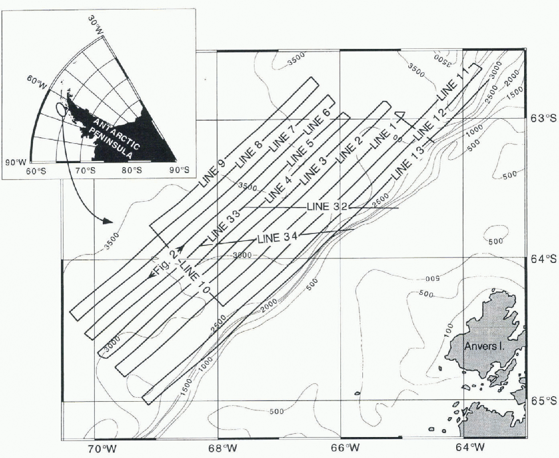
Fig. 1. Location of the study area and profile illustrated in Figure 2. Intervalfor the bathymetrie contours is 500 m. Bathymetrie contours are from a preliminary map by the SEDANO working group.
Three types of morphologies can be recognised in the sediment mounds: symmetric and strongly asymmetric with the steeper side facing northeast or southwest (Fig. 2). The crests of the drifts are 500 m to 1 km above the nearest channel axis. These channels are incised 80-170 m with respect to the surrounding uneroded sea floor. Thus, we consider that the sediment mounds have been only slightly modified by incision of the channels. in BPS records the seismic facies of the sediment mounds are mainly parallel-stratified. Chaotic, transparent and semi-transparent facies appear interbedded with in the stratified ones or form lenticular morphologies (Fig. 2). in the channel thalwegs chaotic and semi-transparent facies appear, while divergent-stratified and sigmoidal are locally present in the channel margins, forming levee-like deposits.
The BPS profiles show that the dominant process in the study area is hemipelagic sedimentation, as this process is commonly associated with uniform parallel-stratified facies. However, instability processes are important with in the sediment mounds covered by this survey. Evidence of instability is provided by the chaotic, transparent and semi-transparent facies, which we interpret as having been generated by the different degrees of disintegration of the original sediment mass. The thickness of the individual deposits related to instability is highly variable, and ranges from a few ms to a maximum of 40 ms. Laterally such deposits can extend up to 100 km, and individual events can reach 150 km3.
Scars on top of the sediment mounds and on their flanks can also be observed truncating the stratified facies. This evidence suggests that instability processes originate near the crests of the sediment mounds, although other sources, such as the channel margins, have also been identified.
Several bodies corresponding to single-event instabilities can be observed in the BPS profiles. These bodies can be grouped in six main levels that appear to correlate well between the different mounds, probably indicating that such processes are cyclic and driven by regional factors. Gravity cores taken in the study area have shown that the upper 6 m (about 8 ms) correspond to the transition between the Last Glaciol and the present-day interglaciol (Reference Camerlenghi, Rebesco, Pudsey and RicciCamerlenghi and others, 1997).Thus our data probably represent several Glaciol-interglaciol cycles, and each of the different levels at which instability-related deposits have been observed may correspond to a different cycle.
4. Discussion and Conclusions
The overall system of mounds and channels seems to be stable and, with in the interval represented on our BPS profiles, the channels have not migrated, allowing a relatively stable sediment-mound morphology to be main-tained. However, flow this morphology is affected by the channels and to what extent the sediment mounds control the channels pathway, are still unresolved questions.
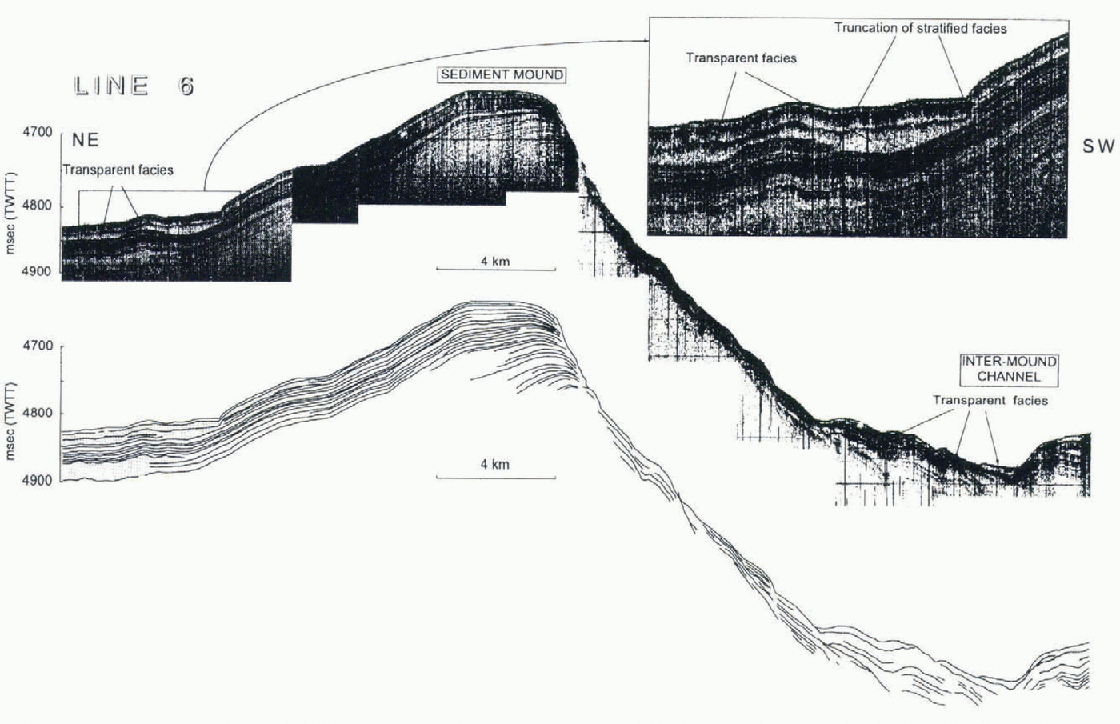
Fig. 2. High-resolution RPS profile and interpretation, showing one of the sediment mounds (mound 3 of Rebesco and others, 1906). Note the presence of transparent facies, interpreted as debris flows, on the northeastern flank and in the channel to the southwest. Note also the presence of slumps on the southwestern flank of the sediment mound.
From our BPS data we infer that in recent times (150-0 ms) bottom currents have not played an important role in shaping the sediment mounds. Only in the most distal part and in the uppermost part of one of the sediment mounds does the configuration of the reflectors allow us to infer slight bottom-current interaction. Hence, hemipelagic sedimentation should have draped and preserved the mound morphology formed during the drift-growth stage.
After hemipelagic sedimentation, mass-wasting seems to be the second most important process taking place on the sediment mounds. Thus, from evaluation of our BPS data, we consider that the palaeoenvironmental potential of the four northernmost sediment drifts along the continental rise off Graham Land is not as great as has previously been suggested (Rebesco and others, 1996), since large amounts of rcmobilised material exist.
Various triggering mechanisms able to generate the different mass-wasting events can be invoked in terms of the cyclic pattern and widespread distribution of transparent masses: (1) sediment pore-pressure fall and rise coinciding with changes of sea level; (2) periods of high sediment input coinciding with advance of grounding ice and sea-level fall (reinforced by item 1); (3) earthquakes.
Acknowledgements
This work was supported by the project ANT95-0889-C02-01, funded by the Spanish National Agency for Science and Technology (CICYT), and the Comissionat per a Universitats i Recerca (CUR) of the Generalitat de Catalunya project GRQ94-1026. R. Urgeles held a Fellowship of the CUR. We would particularly like to thank the master and crew of the R/V Hespërides for their efficiency and cooperation at sea. Constructive reviews from R. D. Larter and L De Santis are also acknowledged.


