


1. INTRODUCTION
Navigation is the process of object motion control (Specht, Reference Specht2007), thus determination of position is its essence. One type of navigation is maritime navigation, which for several thousand years has used terrestrial, and for dozens of years radio-navigation systems, including methods of determining position by satellite. It is believed that the beginning of the development of radio-navigation is the discovery of radio waves and the invention of the radio in 1895 by Alexander Popov (Urbański and Posiła, Reference Urbański and Posiła1966), which resulted in the emergence and development of equipment and radio-navigation systems. In 1897 Guglielmo Marconi established radio contact for the first time with a ship located approximately 20 km away, and four years later he sent a message across the Atlantic (from England to Canada) (Hofmann-Wellenhof et al., Reference Hofmann-Wellenhof, Legat and Wieser2003). The first radio-navigation systems were non-directional (circular) beacons rendering it possible to determine radio location by means of a (physically or electronically) rotating antenna. They were constructed in around 1897 in England (Urbański and Posiła, Reference Urbański and Posiła1966) and used for navigation at sea in 1921 (Januszewski, Reference Januszewski2009), although the first radio ship-finding attempts took place in 1903.
During World War II solutions were developed enabling the measurement of: radio location, distances, or their differences. These were the following systems: GEE (United Kingdom, 1942–1970, accuracy of 0·15–1·6 km); CONSOL (Germany, 1940–1991, radio location accuracy of 0·6–7·5°); LORAN A (USA, 1943–2000, accuracy of 2–3 km); LORAN C (USA, 1957-today, accuracy of 0·25–0·46 km) (Groves, Reference Groves2008; Proc, Reference Proc2014), so that it was possible to draw items on a chart directly. The invention of the transistor in 1948 and its versatile application in radio-navigation in the 1970s led to the emergence of the first radio-navigation systems with a global reach, such as: OMEGA (1971–1997, accuracy of 2–4 km); TRANSIT (1964–1996, accuracy of 0·2–0·4 km); TSIKADA (1978–2003, accuracy of 0·1 km) (Groves, Reference Groves2008; Januszewski, Reference Januszewski2009). Subsequent years brought solutions from satellite positioning (GPS, GLONASS, BEIDOU, GALILEO) that determined the shape of modern radio-navigation in the world. Throughout the last 100 years radio-navigation systems have evolved from support systems for determining the radio direction, through measuring the distances or their differences enabling accurate positioning within a few hundred metres, to the precise positioning solutions of Global Navigation Satellite Systems (GNSS) (Nitner and Specht, Reference Nitner and Specht2012).
In Poland the beginnings of radio-navigation date back to the 1950s when the network of non-directional coast RCs was set up, covering the Polish economic zone. This radiobeacon arrangement provided the possibility to determine the position (to deliver at least two radio measurements simultaneously) at any place. The complex process of calculation and application of the results on the map was significantly improved after the installation (in 1970) off the Swedish coast of the 0A chain of the Decca Navigator System (DNS) (Proc, Reference Proc2014). It became the primary positioning system for ships (Mark 5 series receivers) and navy ships (Russian Pirs receivers), until the beginning of the 1990s, when the first Global Positioning System (GPS) receivers appeared.
Particularly interesting from a technical point of view, local area radio systems operating on the Polish coast were: the phase location system AD-2 - developed in the 1970s on the waters of the Bay of Gdańsk intended for positioning tankers entering the North Port (Winogradow, Reference Winogradow1978) and SYLEDIS - designed for piloting and hydrography of the port complex of Szczecin - Świnoujście (Kopacz et al., Reference Kopacz, Morgaś and Pawłowski2001). This paper describes those various systems while using a uniform criterion space: a general description, architecture and principle of operation, positioning accuracy, and use of a system in the sea basin of the Republic of Poland (RP).
2. MARITIME CIRCULAR RADIOBEACONS (RC)
2.1. General description
Maritime Circular Radiobeacons (RC) were the first method of positioning using radio waves, which provides the possibility of implementing positioning systems with a range of up to 200 NM. The first non-directional RC for maritime navigation was set up in New Jersey, USA in 1921 (Januszewski, Reference Januszewski2009), starting as early as the 1920s, with the installation of radio direction finders on ships for measuring the radio bearing in the direction of the radiobeacon commenced (Urbański and Posiła, Reference Urbański and Posiła1966). Radiobeacons were usually located near lighthouses or installed on beacons, light vessels or ocean weather ships (Hydrographic Office of the Polish Navy, 1971). In 1991 there were approximately 1300 maritime RC that worked within the band 283·5–315 kHz and had a range of 20 to 200 NM (International Telecommunication Union, 1986; Januszewski, Reference Januszewski1997). At the end of the twentieth century radio direction finding was abandoned as a method of determining the position of vessels as it has rather low accuracy. Part of the existing infrastructure was used for the transmission of Differential GPS (DGPS) corrections. For example the radiobeacons in Dziwnów and Rozewie currently transmit DGPS corrections (Dziewicki and Specht, Reference Dziewicki and Specht1996).
2.2. Architecture and principle of operation
Radiobeacons emitted non-directional signals, which were then picked up by the directional receiving antenna mounted on the vessel (Jagodziński, Reference Jagodziński1961). In this way it was possible to determine the vessel observed position that in terrestrial navigation is the intersection of at least two position lines. Such lines could be a radio bearing, i.e. the sum of the actual heading of the ship and the radio course angle included between the axis of symmetry of the fore part of the vessel and the direction from which the radio wave emitted by a given broadcasting radio station reaches the direction-finding antenna. In order to facilitate and speed up the bearing performance, the beacons were often grouped in a so-called “chain”. These included from two to six broadcasting radio stations and worked on the same carrier frequencies. Each of them had a separate and distinct modulation frequency and a separate hallmark also referred to as a beacon code (Łucznik and Sochacki, Reference Łucznik and Sochacki1981).
RCs broadcast at regular intervals signals corresponding to the so-called “program” of radiobeacons. Using Morse code they emitted an identification signal and a continuous signal. The former allowed the user to identify the radiobeacon code, while the latter allowed them to determine bearing. Until 1992 this program was identical for all radiobeacons and can be seen in Figure 1.

Figure 1. 1-minute program of maritime RC applied before 1 April 1992 (Januszewski, Reference Januszewski1997).
Because the then radio direction finding stations could not correctly determine radio direction in all circumstances, it was decided to modify the maritime radiobeacons program so that the duration of a continuous signal was extended, and the duration of identification signals was reduced (Figure 2).
Figure 2. 1-minute program of maritime RC applied from 1 April 1992 (Januszewski, Reference Januszewski1997).
2.3. Positioning accuracy
The error with which the observed position of the vessel was found depended on: the accuracy of the radio bearing, the angle of intersection of these radio bearings, and the distances between the intersection of these radio direction findings from individual radiobeacons (Górski et al., Reference Górski, Jackowski and Urbański1990; Weintrit and Specht, Reference Weintrit and Specht2014). It should be noted that under optimal conditions a radio bearing may be determined with an accuracy of no less than 2° (Hydrographic Office of the Polish Navy, 1971; National Geospatial-Intelligence Agency, 2005). Also important is the fact that each position line of a bearing, including a radio direction finding bearing, is an orthodromic line, hence the problems with the accuracy in determining the position on a chart in the Mercator projection.
2.4. Maritime radiobeacons (RCs) in RP sea basins
In 1970 in the territory of Poland there were seven maritime RC that formed three chains. The first chain, numbered 0003, included radiobeacons in Krynica Morska (f = 310·3 kHz, ϕ = 54·23°N, λ = 019·27°E, d = 50 NM) and Hel (f = 310·3 kHz, ϕ = 54·36°N, λ = 018·49°E, d = 50 NM). The second, numbered 0006, was formed by radiobeacons in Rozewie (f = 287·3 kHz, ϕ = 54·50°N, λ = 018·20°E, d = 50 NM), Łeba (f = 287·3 kHz, ϕ = 54·46°N, λ = 017·33°E, d = 50 NM) and Ustka (f = 287·3 kHz, ϕ = 54·35°N, λ = 016·51°E, d = 50 NM). The last chain, numbered 0009, included radiobeacons in Kołobrzeg (f = 312·6 kHz, ϕ = 54·11°N, λ = 015·33°E, d = 60 NM), Świnoujście (f = 312·6 kHz, ϕ = 53·55°N, λ = 014·17°E, d = 60 NM) and Stubbenkammer (f = 312·6 kHz, ϕ = 54·34°N, λ = 013·40°E, d = 70 NM) (Hydrographic Office of the Polish Navy, 1971). See Figure 3.
Figure 3. Coverage of individual chains (Hydrographic Office of the Polish Navy, 1971; Łysejko, Reference Łysejko2012).
3. DECCA-NAVIGATOR SYSTEM (DNS)
3.1. General description
DNS was a mid-range hyperbolic radio-navigation system, developed by William O'Brien in the years 1936–1939 in the USA. Later, the concept was developed jointly with Harvey Schwarz (Januszewski, Reference Januszewski1997; Proc, Reference Proc2014) in the UK by the Decca Record Company (Blanchard, Reference Blanchard2015). Tests, carried out in the Irish Sea 1942–1943, helped to develop technical solutions facilitating the launch of the first chain on the day before the landing of Allied forces in Normandy in 1944 (a chain of three stations: Chichester - Master A station, Swanage - Slave B station, and Beachy Head - Slave C station) provided the ability to precisely position the Allied fleet (Blanchard, Reference Blanchard2015; Proc, Reference Proc2014).
After World War II Decca Navigator Ltd. was founded, which established the first commercial chain of the system in 1946 in Southern England. Until the 1990s the DNS system was the primary positioning radio-navigation system used in coastal shipping worldwide (Weintrit, Reference Weintrit1992). Operational areas included: Eastern Europe, Canada, Japan, South Africa, United Arab Emirates, Bangladesh, Nigeria, India and Australia. At its peak there were 55 chains (Groves, Reference Groves2008), but by 1996 this had reduced to 30. The number of receivers used in 1991 was estimated at 225,000 units (Januszewski, Reference Januszewski1997). Major Baltic chains were switched off at the end of 1999. The last of the chains (9C, Japan, Hokkaido) worked until March 2001 (Proc, Reference Proc2014).
3.2. Architecture and principle of operation
The basic element of the system architecture was a chain, consisting of a master station and two or three subordinate stations (usually located at a distance of 80–120 km from the main station). The principle of operation of the DNS consisted of measuring the phase difference of signals between the master station and the subordinate stations, which in the form of differences in distance were presented on charts in the form of a grid of hyperbolae (Januszewski, Reference Januszewski1997; Proc, Reference Proc2014). The system used broadcast radio signals emitted at frequencies from five ranges: 70·087–70·583 kHz, 84·105–85·900 kHz, 112·400–114·533 kHz, 114·943–117·397 kHz, 126·157–128·850 kHz with a frequency multiple access (Frequency Division Multiple Access) (Proc, Reference Proc2014). A ship receiver, moving in the zone of an operating system, performed phase difference measurements of radio signals coming from pairs of stations: master and red, and master and green etc. (Figure 4). At position (1) the receiver is on a line perpendicular to the base line (distances to both stations are identical), and the measured phases difference is 0. At point (2) the phase difference increases by the value of Δϕ = 2π, hence the difference in distance will increase by the value of the length of a radio wave corresponding to the wavelength comparator, in which the measurement of phases difference is performed (λ p). Similarly, at point (3), where Δϕ = 4π, and the distance difference will be Δd = 2λ p, hence the relationship between the measured phases difference Δϕ, and the difference in the distance (d 1 − d 2) between a pair of stations (master and red, and master and green) can be written down as (Urbański and Posiła, Reference Urbański and Posiła1966):
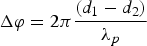 $$\Delta \varphi = 2\pi \displaystyle{{(d_1 - d_2)} \over {{\lambda}_p}}$$
Figure 4. Principle of operation of DNS (Urbański and Posiła, Reference Urbański and Posiła1966).
The ship receiver performed the phase difference measurement with an accuracy of 1°. As the distance from the master base line increased the width of position band grew (d), the accuracy of the measurement decreased as the distance to the master base line increased (between the master and slave stations) (Urbański and Posiła, Reference Urbański and Posiła1966):
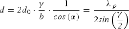 $${d = {\it 2}d}_{0} \cdot \displaystyle{{\gamma} \over {b}} \cdot \displaystyle{{1} \over {{\it cos}\left( {\alpha} \right)}} = \displaystyle{{{\lambda} _{\,p}} \over {{2\it sin}\left( {\displaystyle{{\gamma} \over {\it 2}}} \right)}}$$
Where d is the width of a position band, d 0 is the width of a position band at the master base line, α is the angle between a symmetric master base line and a direction defined from its intersection on a master base line indicated towards the ship receiver (marked on Figure 4 for point No. 3) and γ is the reference angle between rays connecting the ship with master and slave stations (marked at Figure 4 for point No. 3).
3.3. Positioning accuracy
Determination of the position was acceptable in the context of a single chain, because it provided time synchronization of the broadcast, for which the master station was responsible. The primary factors determining the accuracy were: an angle of intersection of the position lines (hyperbolas) used to determine the position, a distance from the station and a time of day affecting the signal propagation conditions (i.e. the troposphere effect). Accordingly, the positioning accuracy ranged from 50 m during the day to 200 m at night. For maximum ranges (300–400 NM) it reached a value of up to 800 m.
3.4. Decca-Navigator system in RP sea basins
The Polish economic zone area was covered entirely by the Swedish chain operations 0A - South Baltic (launched in 1970, switched off in 1999) with stations located in Holmsjö (Sweden, master, f = 84·100 kHz, ϕ = 56·450°N, λ = 015·667°E), in Sandhammaren (Sweden, slave red, f = 112·133 kHz, ϕ = 55·400°N, λ = 014·183°E) and in Burgsvik (Sweden, slave green, f = 126·150 kHz, ϕ = 57·017°N, λ = 018·250°E) (Proc, Reference Proc2014). In the Baltic straits the closest of the available chains was a Swedish chain (4B - North Baltic) and a Danish one (7B - Danish).
Figure 5. Chains of DNS available in RP sea basins in years 1948–1999 (Proc, Reference Proc2014).
4. AD-2 SYSTEM
4.1. General description
The AD-2 was a radio-navigation phase location positioning system, which was built by the Institute of Telecommunications of Gdańsk University of Technology (PG). Its main task was to provide navigation cover on the waters of the Bay of Gdańsk, and in particular providing positioning security for ships arriving in the newly constructed North Port in Gdańsk (Kopacz and Urbański, Reference Kopacz and Urbański1989). In 1976 the Maritime Office in Gdynia made its first attempt at implementing the AD-2 system. Over the two years of initial operation the system met technical and operational assumptions posed by the Polish Government Institute of Telecommunications, and then it was designated for use (Winogradow, Reference Winogradow1978). The AD-2 system worked until 1999, when its broadcasting stations were disassembled (Tomczak-Janowski, Reference Tomczak-Janowski2011). The basic element of the system architecture was a chain, consisting of a master station and three subordinate stations. During the operation of the AD-2 system there was only one chain located on the Bay of Gdańsk.
4.2. Architecture and principle of operation
The system consisted of broadcasting stations that emitted synchronous signals at regular intervals at two frequencies f 1 and f 2 (f 1 – measurement frequency; f 2 – identification frequency of the hyperbolic band) being, respectively: 1920 kHz and 1728 kHz (Januszewski, Reference Januszewski1984). On the basis of the measured phase difference of signals of the station on the ship receiver indicator there was displayed the number of the hyperbolic belt. The selected two pairs of broadcasting stations (Figure 6) (D-B, D-C and D-A, D-B) were drawn on navigation charts as corresponding hyperbolic grids. By reading the relevant hyperbolic belts the navigator could determine the observed position of the vessel, at the intersection of the two selected hyperboles (position lines). It should be noted that the AD-2 system receivers were able to connect to a minicomputer which could then convert the hyperbolic coordinates into geographical ones (Tomczak-Janowski, Reference Tomczak-Janowski2011).
Figure 6. Accuracy zones for two variants of pairs of stations for AD-2 system (Winogradow, Reference Winogradow1978).
4.3. Positioning accuracy
The selection of frequencies f 1 and f 2 increased the width of the hyperbolic belt compared with the width corresponding to the frequency f 1 in relation f 1/(f 1 − f 2) = 10. This allowed broadcasting stations to provide the opportunity to determine the position at a range up to 100 NM. The instrumental accuracy for determination of a positional line was equal to 0·01 of the width of the position (reference) belt. In the vicinity of the reference base line connecting the various stations, the accuracy of the system was less than 1 m (Januszewski, Reference Januszewski1984; Januszewski and Szymoński, Reference Januszewski and Szymoński1982). Figure 6 presents the accuracy zones for two pairs of broadcasting stations (D-B, D-C and D-A, D-B) of the AD-2 system.
4.4. AD-2 system in RP sea basins
The AD-2 consisted of a master station (D) located in Górki Zachodnie and subordinate stations: a dolphin or artificial islet “F” located on the waters of the Bay of Gdańsk (station A), in Krynica Morska (station B) and Władysławowo (station C). In 1985 floe and ice caused flexion of the base of dolphin “F”. Station A was so damaged that the authorities decided to blow it up. From that moment the AD-2 chain in the Bay of Gdańsk worked with three broadcasting stations, until 1999 (Tomczak-Janowski, Reference Tomczak-Janowski2011).
5. SYLEDIS SYSTEM
5.1. General description
The SYLEDIS system (SYstem LEger por mesure la DIStance) was a terrestrial, radio-navigation positioning system operating in the Ultra High Frequency (UHF) frequency range including: 408–434 MHz and 420–450 MHz. SYLEDIS was a medium-range system, and its operational zone covered 80–120 km from the reference station. It was implemented for use in the early 1980s. The manufacturer was the French company Sercel S.A. It was intended for positioning oil extraction activities in the North Sea, where several chains of this system were set up (Loweth, Reference Loweth1997). In 1999, it was activated on the waters of the Pomeranian Bay as a back-up (to the DGPS system) with an objective to ensure precise positioning of piloting activities of the port complex of Szczecin - Świnoujście and to deliver hydrographic work.
5.2. Architecture and principle of operation
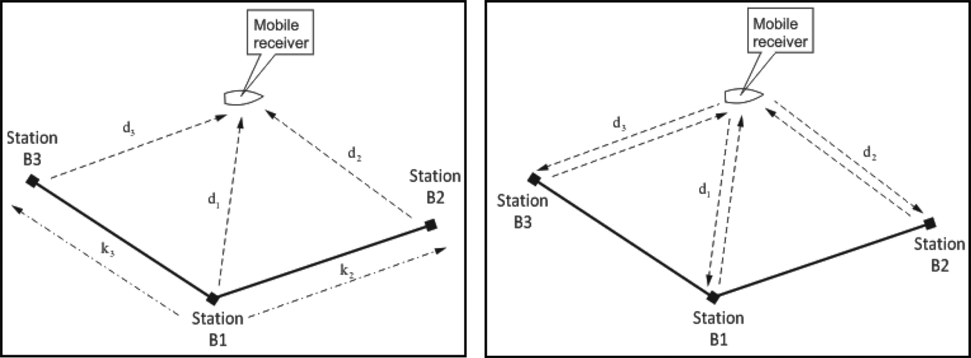
The SYLEDIS system works on the basis of chains consisting of several stations. Depending on need the chain can be configured in a passive mode (control of the operation is carried out from one of the stations - called the master station) or an active mode in which the ship's receiver controls the work. The system uses measurement of the distances between the receiver and stations, or their differences. For this purpose, pseudo-random binary codes of 127 bits are used, that are generated using 7 bit shift registers with feedback. The broadcasting time of a single bit is 0·52 μs, and a code period is 66·6 μs. The system operates in chains whose central frequency is selected from the range 408–448 MHz in steps of 2·5 kHz or 5 kHz, with a 2·5 MHz bandwidth (99% power). The distance measurement accuracy is higher than 0·5 m, ensuring the accuracy in position determination from 1 to 10 m beyond the range border (the radio horizon). In a passive mode (pseudorange) the broadcasting stations are temporally synchronized. One of them is the master station (Figure 7, station B1) transmitting signals to other stations and the receiver. The subordinate stations - slaves (Figure 7, stations B2 and B3) retransmit the received signals from the master station to the user (Sercel S. A., Reference Sercel1981).
 $$d_1 = D_1 + D_0 = \sqrt{(X - X_1)^2 + (Y - Y_1)^2} + D_0$$
 $$d_2 = D_2 +D_0 +d_12 =\sqrt{(X - X_2)^2 + (Y - Y_2)^2} + D_0 + k_1$$
 $$d_3 = D_3 + D_0 + d_13 = \sqrt{(X - X_3)^2 +(Y - Y_3)^2} + D_0 + k_2$$
where d 1, d 2, d 3 are the measured distances between a receiver and a broadcasting station, (X 1, Y 1), (X 2, Y 2), (X 3, Y 3) are the coordinates of the SYLEDIS system stations, (X, Y) are the coordinates of the SYLEDIS system receiver, D 0 is the clock fault towards the master station, D 1, D 2, D 3 – real distances between stations and a receiver and k 1, k 2 are the length of reference lines between the master and slave stations.
Figure 7. Principle of operation of the SYLEDIS system: in a passive (left) and in an active mode (right) (Sercel S. A., Reference Sercel1981).
In active mode the ship's station performs system control by sending radio signals to (shore) stations to determine the distances to more accurately determine position (Sercel S. A., Reference Sercel1981).
5.3. Positioning accuracy
The system worked at a very short wavelength of 70 cm. For this reason, the positional line designation error was 0·5 m (RMS) and up, while ensuring a good station geometry (Bakker et al., Reference Bakker, De Munck and Strang van Hees1989). Beyond the reach of the radio horizon the error grew within the range of 5–10 m. The manufacturer of the system offered antennae whose directivity characteristics could be arbitrarily adjusted, hence it was possible to obtain a range of up to more than 100 km from the station. But with this solution the precision of the position determination already reached tens of metres.
5.4. SYLEDIS system in RP sea basins
In 1999 in the waters of the Pomeranian Bay the SYLEDIS radio-navigation system was implemented. The architecture of this system consisted of shore stations which were located so as to be able to efficiently change the chain operation variant (passive or active). The chain of the SYLEDIS system operating in an active mode consisted of stations located on: lighthouses in Niechorze, Świnoujście and Greifswalder Oie, the tower of the harbour master's office in Świnoujście and the hydrographic survey ship “Planet” (a mobile station). The chain operating in a passive mode used almost identical stations as in the active mode (instead of the mobile station they used the border leading light in Świnoujście). In 2001 dynamic measurements were carried out, which helped to determine the accuracy of the SYLEDIS system. The differences between the positions measured by the SYLEDIS system and the positions adopted as model ones (geodesically measured) amounted to 5·7 m (p = 0·95) (Kopacz et al., Reference Kopacz, Morgaś and Pawłowski2001).
The SYLEDIS system, due to the lack of ship's receivers and because of the DGPS system already working on the waters of the Pomeranian Bay operating on the basis of the reference station Dziwnów was not practically applied by users at sea. The dismantled broadcasting stations of the system along with the receivers are at the disposal of the Maritime Office in Szczecin. It is interesting that in 2014 the maritime administration listed the SYLEDIS system as a system being a part of the infrastructure providing access to the Ports of Świnoujście and Szczecin.
6. DIFFERENTIAL GPS (DGPS)
6.1. General description
Differential GPS (DGPS) is a positioning system that transmits positional pseudorange GPS fixes/corrections (determined at the reference DGPS station) to maritime users, allowing positioning with accuracies significantly exceeding autonomous GPS positioning. It is designed to protect coastal waters navigation, entrances to ports and hydrography. In terms of radio use it applies a frequency range of 283.5–325 kHz and Minimum Shift Keying (MSK) technique modulated signals. In 1989 the first test of the DGPS system based on the Low Frequency/Medium Frequency (LF/MF) band and a maritime radiobeacon Montauk Point located on Long Island (USA) was conducted, and on 15 August 1990 it began its continuous operation as the world's first public access DGPS. In the 1990s it was common to locate such stations in most coastal waters of the world. Until 2013 there were 283 DGPS reference stations erected, including two Polish ones: Rozewie and Dziwnów (1994) (Kopacz and Specht, Reference Kopacz and Specht2014; Specht, Reference Specht2007).
6.2. Architecture and principle of operation
The Polish DGPS system consists of two DGPS reference stations located in Rozewie and Dziwnów, the central station in Gdynia whose task is to remotely control the reference stations and to supervise the entire system. Until 2009 the Polish DGPS system also included monitoring stations (Kopacz and Specht, Reference Kopacz and Specht2014) (located in the same place as the reference stations), whose task was to control the system operation parameters in real time. The idea of the system is to determine the measurement error of the measured pseudorange to the GPS satellites, and to compare it with the actual distance calculated based on the GPS coordinates of the reference station antennas and the satellite coordinates. Their difference, called the pseudorange correction/fix, is transmitted in the frequency range of 283·5–325 kHz to maritime users, who by using the DGPS receiver take it into account in the process of determing position. The reference station consists of a computer, two GPS receivers, two modulators, two amplifiers and a broadcasting antenna. Doubling of devices provides the ability to achieve high availability of signals (Specht, Reference Specht2007).
6.3. Positioning accuracy
The main factor that decided the accuracy of position was selective availability, namely the technique of intentionally lowering the accuracy of GPS applied by the US government until 2 May 2000 (Specht, Reference Specht2007). After it had been disabled, the positioning accuracy of the DGPS system increased from the level of 5–10 m to 1–2 m (Śniegocki et al., Reference Śniegocki, Specht and Specht2014). Currently, the positioning accuracy is essentially dependent on the age of pseudorange corrections received by the user of the system. Age of corrections is the time that has elapsed since their establishment on a DGPS reference station until they were included in the receiver in the process of determining the position. DGPS systems use transmission speeds of 100 and 200 bauds. The average age of corrections is approximately 7 s and for the latter around 3 s respectively. Another factor affecting the accuracy is the distance between the reference station and the user.
6.4. DGPS system in RP sea basins
In February 1994, initiated by the Polish Hydrographic Office there was developed “The Concept of Maritime Radiobeacons Location on the Polish Coast”, primarily concerning the modernisation of the Polish system of maritime radiobeacons, which also presents the five distribution variants for DGPS reference stations on the Polish coast. It was implemented by the Else Technical and Research Service Co. Ltd., from Gdańsk (Else Technical and Research Service Co. Ltd., 1994). Simultaneously, the Polish Hydrographic Office commissioned the Polish Naval Academy to draw on scientific expertise including assumptions for the implementation of this project. A study entitled “Criteria for the Selection of DGPS Reference Station on the Polish Coast” was carried out in the Institute of Navigation and Sea Hydrography of the Polish Naval Academy (Kopacz et al., Reference Kopacz, Dziewicki, Fic and Specht1994) on the basis of a commission from the Polish Hydrographic Office No. BHRP-1058/94 of 19.10.1994. In the years 1994–1995 the system was subjected to thorough testing of position accuracy, availability, reliability and credibility, to finally start the operating mode in 1996. Over the years both stations had transmitting antennae exchanged, as well as their other equipment (2009). The range of both stations is around 200 km. Figure 8 illustrates the coverage of Polish reference stations (Rozewie and Dziwnów) defined by measurement in 2014 (Śniegocki et al., Reference Śniegocki, Specht and Specht2014).
Figure 8. Coverage of Polish DGPS reference stations in 2014 (Śniegocki et al., Reference Śniegocki, Specht and Specht2014).
7. CONCLUSIONS
In this paper the authors describe the history of maritime radio-navigation positioning systems used in Poland. The authors confined themselves to the description of the main systems used in the sea areas of the Republic of Poland in the years 1948–2015. Due to the volume of the publication they omitted systems used by the Polish Navy.
When analysing the development of maritime positioning techniques applying radio waves it should be noted that, over the years, not only were the latest worldwide solutions available used, but also a proprietary and generic system of positional radio-location has been developed (AD-2); also, the SYLEDIS precise navigation system was implemented to work in the Pomeranian Bay; moreover, Poland was one of the first countries in the world to launch a national DGPS network, which is still operating today.


 Open access