Taking on Tornadoes: Twitter and Dual-pol radar join forces
11 February 2014
Last update: 11/02/14 10:59
An article published in Disaster Medicine and Public Health Preparedness has revealed that the combined use of Dual-Pol radar and Twitter has the potential to significantly improve outcomes in communities faced with tornadic activity.
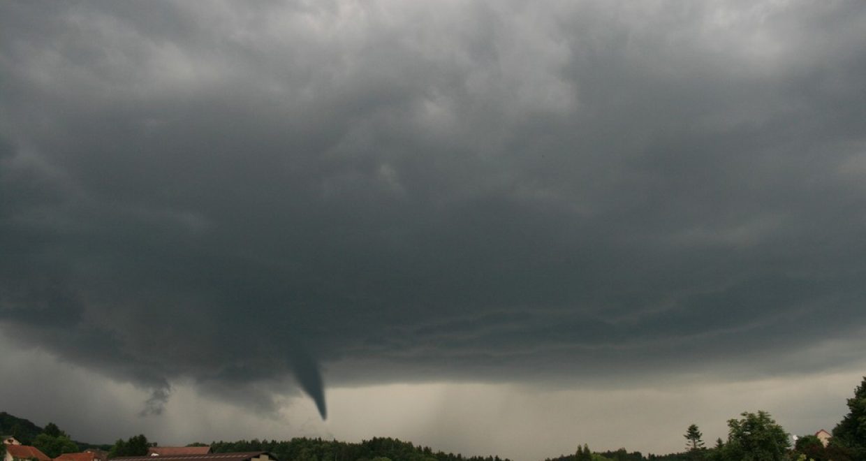
On February 10, 2013, at approximately 5:00 PM, an EF-4 tornado* with sustained maximum winds of 170 mph struck Hattiesburg, Mississippi, a small city with a population of approximately 45 000 residents. The tornado traversed densely inhabited areas including residential homes, businesses, and a large state university, causing $40 million in damage and resulting in 50 reported injuries and no fatalities.
For the first time in the Hattiesburg area, new weather technologies, such as the dual-polarization radar+, combined with the social media entity Twitter were used in a concerted effort to mitigate morbidity and mortality. The article analyzed the combined use of these technologies in preventing injury and death during a violent storm.
Several notable organizations used Twitter during the tornadic events in February. These organizations included the NWS in Jackson, Mississippi (@NWSJacksonMS), the Weather Channel (@weatherchannel), the Sun Herald newspaper (@SunHerald), and WDAM News, Talk and Radio, a local organization (@WDAM).
Twitter users followed weather-related handles for up-to-the-minute information regarding current weather conditions in areas where they maintain community ties. While not always current, the information is disseminated to the public quickly, especially in the event of severe weather in an area that may experience loss of power and Internet service. In this instance, smart phones with high-speed networks, which are owned by more than half of all adults in the United States, may still be able to receive texts and tweets regarding the severe weather.
Twitter users and storm chasers used the terminology from the NWS warnings to inform the public about the severity of this tornado. Along with the strong wording in the tornado warnings issued, the Weather Channel used tweets to describe the specific direction of the tornado, as indicated by radar and storm spotters on the ground. Twitter users in the Hattiesburg community were alerted to the specific location of the tornado and were then able to judge the safety of their current location. The use of the phrase tornado emergency as part of the NWS alerts and tweets also likely raised the alert in communities. Tornado emergency is a phrase that was instated by the NWS in 2005 to alert highly populated areas of a tornado on the ground that is expected to continue to produce a high magnitude of damage along its path coupled with the high likelihood of numerous fatalities.
The danger associated with the tornadic storms in the Hattiesburg area was highlighted with the issued tornado emergency. This type of alert has only been issued a total of 13 times in Mississippi since 2005. These notifications were frequently tweeted by the NWS handles, and were subsequently retweeted. These transmissions enabled the communique to go viral, or to be transmitted exponentially. One of those tweets that mentioned the phrase tornado emergency was retweeted 19 times.
This study revealed that the combined use of Dual-Pol radar and Twitter has the potential to significantly improve outcomes in communities faced with tornadic activity.
The average warning time preceding a tornado is 13 minutes. With the use of Dual-Pol radar, the tornado warning time was 30 minutes in advance of the storm that occurred on February 10, 2013. The dramatic increase in warning time provided local citizens ample time to reach a safe location, and likely was a major factor in the absence of fatalities and critical injuries.
Italo Subbarao DO, MBA, one of the authors of the paper commented, “While we recognize that other forms of risk communication such as television, radio, and other social media outlets were used during the tornado, we believe that Twitter was the most efficiently designed method for communication, particularly with the ubiquitous use of smart phones. This method of risk communication was useful for the public, emergency management, and health care providers to identify the severity of the impending tornado.
“Given the scope of damage sustained, it is no small wonder that fatalities were avoided altogether. The advent of more accurate weather-sensing technologies coupled with the adoption of more recent social media communication channels such as Twitter may serve as an effective early warning system in regions routinely experiencing high frequency of tornadic activity and should be further explored.”
* Tornadoes are severe wind storms that are characterized by a violently rotating column of air that reaches the ground. Tornadoes are classified using the enhanced Fujita (EF) scale, which rates the intensity based on resultant structural damage. A rating of EF-0 is the weakest, with estimated wind speeds of 65 to 85 mph; and EF-5 is the strongest, with sustained winds exceeding 200 mph. During an average year, only 2% of tornadoes are categorized as violent, with ratings of EF-3 and above. Nearly 1000 tornadoes occur in the United States every year and account for an average of 87 fatalities and 1500 injuries.
Mississippi experiences an average of 2 EF-3 or stronger tornadoes per year, with an average of 3 tornadoes of any strength occurring in February.
+ In January, 2013, the NWS (National Weather Service) in Jackson, Mississippi, completed a $225 000 radar upgrade from the traditional Doppler radar to the new dual-polarization radar (Dual-Pol radar).
Related Posts

Wisconsin’s Response to the Coronavirus Pandemic – Now updated
From time to time, until the crisis has passed, the HEPL blog series authors will be given the opportunity to provide short updates on their country/region’s continuing response to this worldwide catastrophe and their further reflections on those responses. Each update will be labelled accordingly with the original response at the bottom of each post. […]

Where Physical and Digital Worlds Collide
In this blog for Data-Centric Engineering, Paul Clarke (Chief Technology Officer at Ocado) documents Ocado’s journey with building synthetic models of its business, its platforms and its underlying technologies, including the use of simulations, emulations, visualisations and digital twins. He explores the potential benefits of digital twins, including the opportunities for creating digital twins at […]

International Women’s Day 2020: Influential women in STEM
International Women’s Day 2020 falls on Sunday, 8th March this year. In the run up to this date, each week day we’ll be highlighting one woman whose accomplishments in science, technology, engineering and/or mathematics not only elevated their fields but also took us one step closer to a gender-equal world. We hope you’ll join us […]
New York’s Response to the Coronavirus Pandemic – Now updated
From time to time, until the crisis has passed, the HEPL blog series authors will be given the opportunity to provide short updates on their country/region’s continuing response to this worldwide catastrophe and their further reflections on those responses. Each update will be labelled accordingly with the original response at the bottom of each post. […]