

Five Coasts and Harbors of the Bronze Age Aegean Characteristics, Discovery, and Reconstruction
For all the indications that sea travel was fundamental to the Mycenaean political economy, we have little evidence for their coastal anchorages, let alone developed harbors or port towns, in the Aegean. We must ask why this is; what, if anything, we can do to recover and investigate them; and why we should want to do so in the first place. These questions form the focus of this chapter.
To tackle the last question first, the importance of identifying specific landing sites instead of merely characterizing the types that would have existed on Bronze Age Aegean coasts (e.g., Morton Reference Morton2001: 6–7) must be established. Many anchorages will have been small, susceptible to alteration over time, and not necessarily accompanied by a settlement or a conspicuous artifact scatter. Is it worth the time and effort to search for them? Surely it is if we are serious about understanding the networks of interactions by land and sea that amounted to the connectivity of daily life, particularly if, following Horden and Purcell (2000: 123), our aim is to reveal “…the various ways in which microregions cohere, both internally and also one with another – in aggregates that may range in size from small clusters to something approaching the entire Mediterranean.” Only by knowing the locations of the coastal nodes in these networks can we fully make use (and sense) of archaeological data bearing on interaction at all scales.
Dedicated harbors as well as anchorages used only intermittently or opportunistically must have been abundant in many regions during Mycenaean times, both because of the morphology of the Greek coastline and because they were needed. As communication by sea expanded, a multitude of anchorages, large and small, was required to ensure that voyaging was as safe as possible, and to facilitate economic and social relationships. Ship captains needed access to safe anchorages to shelter from winds and storms, to procure provisions, and to enter into various kinds of transactions, including trading and raiding. Running out to sea to escape a storm was a maneuver of last resort; to seek a coastal haven was much preferred. At times, ships and their crews were forced to wait for favorable winds, and this could occupy days or weeks during which their needs for sustenance would have to be met. The potential hostility of the local population was a complicating factor that must often have forced crews to seek alternative landing sites. Another function of small, scattered anchorages might have been as convenient pickup points for agropastoral products to be transported by sea in local and regional trade networks (Rothaus et al. Reference Rothaus, Reinhardt, Tartaron, Noller, Foster and Laffineur2003: 40).
Too often, however, the existence of safe, suitable anchorage is taken to be self-evident or based on guesswork that is quite possibly wrong. Often, it seems, the problem of long-term coastal change is simply left unexamined. A common mistake is to assume, implicitly or explicitly, that Bronze Age and modern coastal morphology are essentially the same. Even when some attempt is made to infer changes based on observations of modern coastal landscapes, in the absence of geomorphological analysis the conclusions reached can be misleading or wrong, and are at best limited in their ability to lead to a genuine understanding of ancient coastal environments. The actual changes to Aegean coastlines over time vary widely, but they tend to have localized causes that can only be charted with geoarchaeological techniques. In this chapter, I describe the process of working back to Bronze Age coastlines, and stress the importance of doing so in a systematic way.1
Conditions of Discovery
There are few places on the modern coastline to search for Bronze Age anchorages and harbors that can truly be called “obvious.” Locations that boast fine harbor basins today, or that preserve harbor works from historical periods of the past, are no sure indicators of high potential for harbors of the Bronze Age. One reason for this is changes in maritime practice – mainly ship technology – over time. It is undoubtedly true that small, shallow anchorages perfectly suitable for Mycenaean shipping could not accommodate the large, heavily laden military and commercial fleets of later Greek and Roman antiquity. Thus, to limit the search to prominent historical and modern harbors would be to miss most of the Mycenaean maritime landscape.
A more important reason is pervasive change over time in the physical topography of the coastline, caused by short- and long-term geomorphological processes. The most prominent of these are sea-level change, sedimentation, marine erosion, and tectonics. Eustatic sea-level change, caused by the cycling of ocean waters into and out of the polar ice caps, has had a profound effect on the world's coastlines since the end of the last Ice Age. Following the last glacial maximum circa 18,000 years ago, at which time eustatic sea level lay at 90 to 150 meters below present sea level, global warming induced rapid sea-level rise, interrupted only by the cool Younger Dryas event of 10,000 to 11,000 years ago, until circa 6000 BP (van Andel Reference van Andel1989; Wells Reference Wells, Stein and Farrand2001: 151). In the Mediterranean, maximum sea transgression into coastal areas was reached circa 6000 BP, followed by a stabilization of eustatic sea level. Since that time, global eustatic sea level has slowly risen by no more than five meters or so. Since the LBA, eustatic sea-level rise is only a few meters, a figure that can account neither for observed vertical changes in relative sea level caused by tectonic uplift and subsidence, nor the lateral and vertical changes effected by coastal sedimentation and erosion.
Moreover, the discovery potential for Mycenaean harbors is not the same for all parts of Greece and the Aegean, because regional-scale geomorphological histories may make detection of ancient harbors relatively easier or more difficult. As a result of regional tectonics, some coastlines abound in natural coves and inlets, while others can be characterized as virtually harborless coasts. Faulting of the Greek land mass into mountains and intervening valleys in a general northwest–southeast alignment, followed by inundation of the coasts by the sea, has produced the characteristic pattern on Greece's Aegean (east-facing) shores of promontories separated by deep gulfs, with numerous smaller inlets on a generally rocky coast (Morton Reference Morton2001: 15–16). The Aegean coast of Asia Minor developed deep inlets reaching tens of kilometers inland at places like Miletos, Ephesus, and Troy. These great estuary and delta systems hosted superb Bronze Age harbors, but have silted in completely in historical times, leaving once-great harbors stranded many kilometers inland.
There are other distinctive patterns. Some coastlines are formed by major faults that separate a mountain ridge from an adjacent collapsed and submerged block; these coasts are steep and linear, with few inlets or offshore islands, and thus little safe anchorage (Morton Reference Morton2001: 137). Examples of such “harborless” coasts occur in Epirus and Thessaly (the two flanks of the northern Greek mainland), and on the long northeastern coast of Euboea. They tend to be cliffbound and very deep – difficult places to find holding ground for an anchor or to come ashore for provisions. In a few places, perennial rivers have broken through to the coast, forming broad estuaries and deltas. In Epirus north of the Ambracian Gulf, marine embayments or estuaries at the mouths of the Acheron and Kalamas (Thyamis) Rivers provided safe haven and access to fertile hinterlands. If it can be established that the separation of the two blocks forming such coastlines occurred before the Bronze Age, the candidates for harbor locations are few and the search is simplified.
By contrast, the long, west-facing coastline of Elis in the western Peloponnese has witnessed several sequences of accretional barrier and lagoon formation since the end of the Mesolithic period, with the result that most evidence of Bronze Age coastal landforms and archaeological sites is now buried under meters of sand and wetland deposits. There, investigation of Bronze Age coastal environments requires long-term programs of geological coring, and results remain tentative even after years of study (Kraft et al. Reference Kraft, Rapp, Gifford and Aschenbrenner2005).
The lack of knowledge about Aegean Bronze Age coastlines is also partly a symptom of the general historical trajectory of maritime archaeology in the Mediterranean, which in the twentieth century was dominated by studies of ships and shipwrecks, at the expense of harbors and coastal landscapes (Marriner and Morhange Reference Marriner and Morhange2007: 137–44). The emphasis on ships continues today in both the Old and New Worlds (e.g., Bass Reference Bass2005a; Blue et al. Reference Blue, Hocker and Englert2006; Gould Reference Gould2000). The shipwrecks at Uluburun, Gelidonya, and Point Iria have generated extraordinary information about LBA seafaring and maritime trade, but as restricted spatial and temporal events, they constitute a small part of a much larger picture (Marriner and Morhange Reference Marriner and Morhange2007: 180). When harbors were the object of study, they tended to be the largest and best-known artificial harbors of the Greco-Roman world. Prehistoric and small, natural anchorages and harbors were rarely investigated, nor were there frequent efforts to reconstruct entire “maritime cultural landscapes” formed by networks of landing sites, coastal settlements, and their ties with other communities by land and sea (Westerdahl Reference Westerdahl1992). In this respect, Mediterranean maritime archaeology is less advanced than in northwestern Europe or the Baltic area (e.g., Chapman and Chapman Reference Chapman and Chapman2005; Cunliffe Reference Cunliffe2001; Ilves Reference Ilves2009). Moreover, until recently, maritime archaeology in Greek waters lagged behind other areas in the Mediterranean, such as the Levantine and Turkish Aegean coasts. This can be attributed in part to highly restrictive controls placed on underwater archaeology by the Greek underwater archaeological authority (known as Enalion), particularly with respect to foreign teams. As a result, most of the major projects and innovations in underwater technique were developed on the coasts of countries like Israel and Turkey, where permitting was more liberal (Bass Reference Bass and Bass2005c; Raban Reference Raban, Laffineur and Basch1991). In a policy shift that occurred after 2000, Enalion has invited collaborations with foreign teams, and many are now underway alongside an expanded agenda for Enalion's own projects.
It must be pointed out that a long tradition of coastal geomorphology has existed in the Aegean, targeting coastal change over time in both local and regional settings, for example Franchthi Cave (van Andel and Sutton Reference van Andel and Sutton1988), Asine (Zangger Reference Zangger1994b), Tiryns and the Argive Plain (Niemi and Finke Reference Niemi, Finke and Raban1988; Zangger Reference Zangger1991, Reference Zangger1994a), Pylos (Kraft et al. Reference Kraft, Rapp and Aschenbrenner1980), Dimini (Zangger Reference Zangger1991), Troy (Kraft, Kayan et al. Reference Kraft, Kayan, Brückner, Rapp, Wagner, Pernicka and Uerpmann2003; Kraft, Rapp et al. Reference Kraft, Kayan, Brückner, Rapp, Wagner, Pernicka and Uerpmann2003; Rapp and Gifford Reference Rapp and Gifford1982), Ephesus (Kraft et al. Reference Kraft, Kayan, Brückner and Rapp2000), Miletos (Brückner Reference Brückner, Wagner, Pernicka and Uerpmann2003), and the deltas of the Alpheios (Kraft et al. Reference Kraft, Rapp, Gifford and Aschenbrenner2005) and Acheron (Besonen et al. Reference Besonen, Rapp, Jing, Wiseman and Zachos2003) Rivers. In Greece, this work could generally be accomplished under more easily acquired permits granted by the geological service (IGME). Yet the specific areas in need of development in the Aegean are two: first, there is a lack of systematic programs of research that identify and investigate local and regional maritime cultural landscapes in a holistic way; and second, programs of coastal reconstruction have often not been closely coordinated with terrestrial surveys and excavations, in terms of research design and planning, shared fieldwork and resources, and joint publication. For example, although all the programs of coastal paleogeography cited above sought to address specific archaeological questions, most were not integrated closely with a particular excavation or survey on land. Meanwhile, excavations and regional archaeological surveys on islands and in coastal areas have rarely extended their focus beyond the shoreline, with the result that the potential of integrative concepts, such as the maritime cultural landscape, which situate coastal regions within interactive networks that unite inland, coast, and sea, has scarcely been tapped (Berg Reference Berg2010). Some vestiges of the former restrictions remain as mandated by national legislation covering all archaeological activity, including a limited number of available permits for foreign researchers and a clear distinction between terrestrial and underwater permits (these come under separate authorities, and a project can rarely expect to hold both land and underwater permits in a single year). Yet there are many ways to make collaborative research work within the present regulations: much paleocoastal fieldwork can still be accomplished on land under geological (IGME) permits, and it is possible to bring together mixed Greek and foreign nationals to work in a given locality under separate projects and permits. Nevertheless, moving toward a truly holistic coastal archaeology of maritime cultural landscapes will require fully integrated programs of archaeological and geomorphological investigation of sea and land in coastal regions.
Geomorphology of Coastal Zones
Coastlines are among the Earth's most dynamic geomorphological settings. George Rapp and John Kraft (1994: 71–72) list the characteristic and interrelated processes: “local tectonism; eustatic sea level change; climatic change; ocean currents and wave regimes; the nature and frequency of catastrophic events; sources, types, and quantities of sediments available and the resultant aggradation and progradation of deltaic floodplains into erosional and tectonically derived embayments; and the nature and intensity of human activity.” Over time, even the most stable coastal environments evolve as sediments accumulate or shorelines erode. Local relative sea level moves up or down in response to changes in the absolute level of the land (tectonics, isostasy2), sea (eustasy), or both. Climate and topography control the flow of energy (tides, waves, currents, sediment flux) in a coastal system. The tectonic environment (faults, tectonic events) impacts topography and relative sea level, and sometimes introduces changes to coastal topography that are catastrophic from a human perspective. Finally, human impacts on coastal environments, notably in the form of increased sedimentation, have been detected since the Neolithic period in the Mediterranean. The following discussion summarizes briefly the most important processes and materials involved in long-term coastal evolution, following the thorough treatments of the topic by Lisa Wells (Reference Wells, Stein and Farrand2001) and Michael Summerfield (Reference Summerfield1991: 313–42).
Broadly speaking, a first-order distinction can be made between open coasts and protected coastlines (Wells Reference Wells, Stein and Farrand2001: 150). Many coastlines cannot be characterized as completely open or completely sheltered, but for a coastal location to have been viable as a harbor, it must have been sheltered to at least a considerable degree from winds and waves. Often, because of shifts in wind direction and intensity during the course of the year, the viability of a harbor may respond to seasonal or even day-to-day conditions.
Open coasts are exposed to the full impact of winds and wind-driven waves, creating high-energy environments and landforms dominated by beaches or rocky shorelines. Coastal erosion is common on open coasts, and sediments tend to be relatively coarse with abundant organic material including woody debris or carbonate particles. By contrast, on protected coastlines, wave energy is attenuated by refraction, creating low-energy environments exemplified by estuaries and tidal marshes in which sedimentation dominates coastal evolution and landform development. Sediments are relatively fine grained and may contain highly organic deposits such as peat. Protected coastlines are ideal locations for sheltered harbors.
Long-Term Coastal Evolution
Coastal evolution can be characterized in terms of the relative motion of the shoreline over time in response to the processes outlined by Rapp and Kraft above, and by the resulting landforms, which can appear and disappear with successive periods of coastal change. Joseph Curray (Reference Curray and Miller1964; see also Wells Reference Wells, Stein and Farrand2001: 154–55) proposed a classification of coasts based on their relative motion over a discrete period of time: (1) progradational coasts grow seaward (prograde) as a result of sedimentation; (2) transgressive coasts are submerged as a result of relative sea-level rise; (3) recessive coasts erode landward (marine erosion); (4) regressive coasts emerge as relative sea level falls; and (5) aggradational coasts grow vertically (aggrade) when the rates of sea-level rise and sedimentation are roughly equal (Fig. 5.1). The early Holocene record of the Mediterranean, outlined above, provides a good example of rapid and widespread transgression as global sea levels rose. The maximum transgression is often marked by wave-cut notches in a former sea cliff, or other signs of a paleoshoreline stranded far inland from the modern shoreline. After eustatic levels stabilized circa 6000 BP, these transgressive coasts shifted to progradational, recessive, or aggradational, depending on the rate and dynamics of sedimentation and erosion in a given location. The Aegean coasts of Turkey provide dramatic examples of deep embayments created by the late Pleistocene to early Holocene marine transgression, followed after circa 6000 BP by a gradual but inexorable progradation of tens of kilometers in the major river deltas. The relationship of sea and land created by the interplay of erosion and sedimentation can be altered locally by tectonic movements.
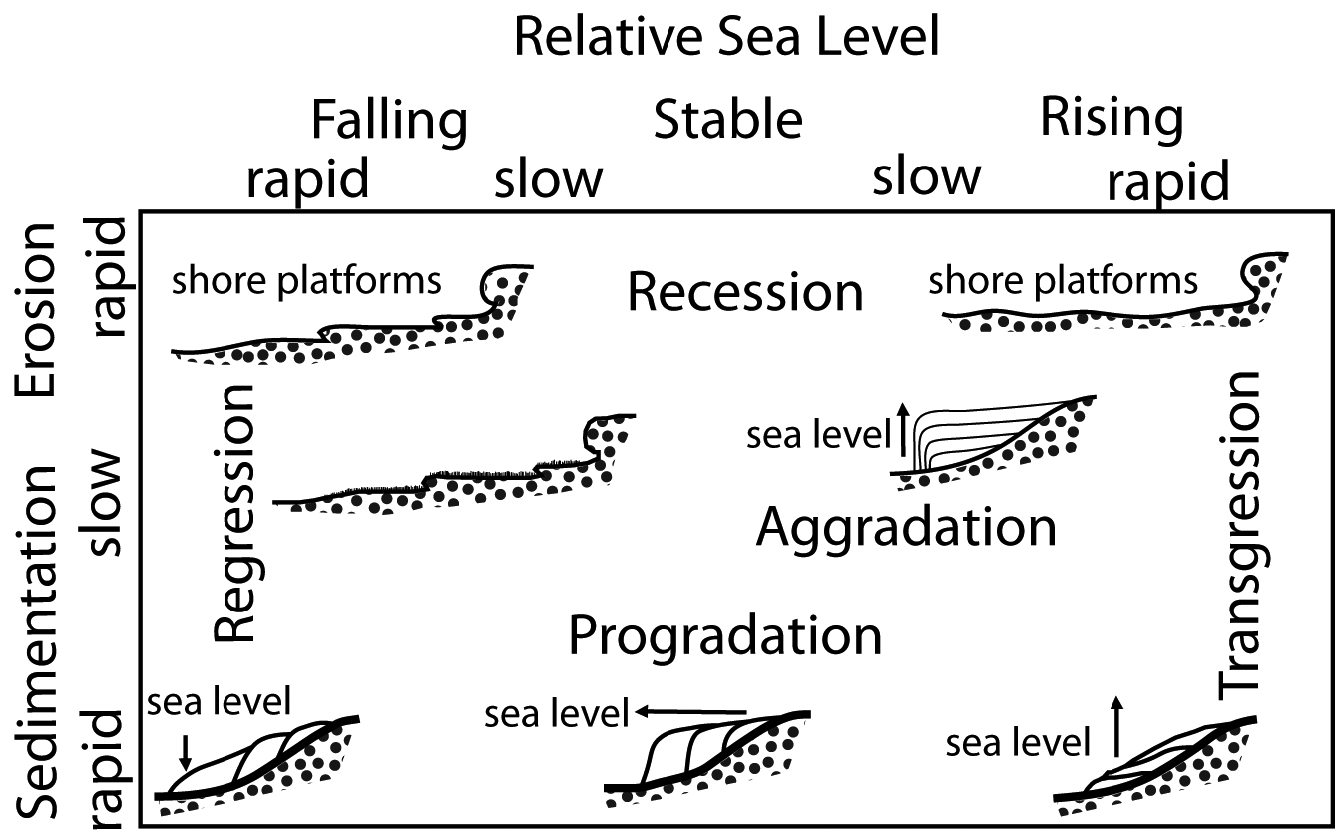
5.1 Classification of coasts by relative motion of the shoreline. After Wells Reference Wells, Stein and Farrand2001: 154, fig. 6.2. Courtesy of University of Utah Press.
Sediment Supply to Coastal Zones
There are three main sources of sediment supply to the coastal zone: (1) the coastal landforms themselves, notably sea cliffs; (2) the land inland from the coast; and (3) material transported from offshore (Summerfield Reference Summerfield1991: 324–25). The volume and nature of the sediments are controlled by geology, tectonics, climate, oceanography, and the topography of the sediment source area (Wells Reference Wells, Stein and Farrand2001: 155). On open coastlines, high wave energy can erode coastal landforms, causing recession and liberating sediment to be transported and reworked. The amount of sediment thus produced depends on wave energy and the degree of consolidation of the cliffs or other landforms suffering erosion.
By far the greatest sediment load, however, is brought to the coast from inland by rivers. On average, mid-latitude coastlines receive more than 90% of their sediment from fluvial sources. Where drainage systems are long and broad (e.g., the Nile, Tigris, Euphrates, Maeander), the material transported to the shore will be predominantly fine grained as coarser clasts are deposited well upstream. By contrast, short, steep drainages carry coarser materials to the coast. In Greece, there are relatively few large, perennial rivers with broad drainage basins (to name two, the Peneios and the Spercheios). Most rivers have a seasonal flow that is heaviest in the winter months as a result of rains that trigger high-energy, swift-flowing torrents capable of transporting much coarse material. As a result, a typical stony beach will consist of a mix of coarser and finer material.
Free sediment is transported in the interface of coast and inshore waters in several ways (Summerfield Reference Summerfield1991: 325; Wells Reference Wells, Stein and Farrand2001: 155–57). Tides and wave action move sediment continuously and more or less perpendicularly into and away from shore. Wind-driven waves can be significant agents of erosion and sediment transport on open coastlines, but because the Mediterranean is a virtually tideless sea, the effect of tides on coastal processes is minimal. Where offshore winds are strong and persistent, substantial amounts of airborne sand-sized and smaller grains can be deposited onshore (aeolian transport). Yet the dominant movement of sediments along Mediterranean coasts is due to oceanic currents (Fig. 5.2). Generally, the fine clay- to silt-sized sediments escape offshore in suspension and are carried away by oceanic currents. The coarser (sand-sized and greater) material ordinarily remains in the littoral zone, to be entrained in longshore currents, which transport material parallel to shore through a process called longshore drift (also known as littoral drift). The most important contributor to this material is alluvial sediment, but sediments from the erosion of coastal landforms as well as material previously entrained in ocean currents can also be present. The rate and volume of longshore transport along a coastline are controlled by current velocity and wave energy, as well as the angle at which waves strike the coast. The impact of longshore drift on coastal configuration depends on the presence or absence of features of coastal topography and inshore bathymetry that act to impede or facilitate sediment movement. Sediment remains in transit until a sediment sink drains it offshore or an impediment causes deposits to form against it and build up over time. Thus, on linear coasts, longshore drift may proceed with little interruption or effect on coastal configuration. Where coasts have irregular configurations, however, as is so often the case in Greece, longshore sediments become trapped against headlands, offshore islands, delta formations, and other prominent features (Fig. 5.2). These deposits contribute to the development of landforms such as barrier islands, spits, and sandbars, behind which lagoons form. The elongated form of these deposits reflects the prevailing direction and strength of the longshore currents. The long and complex history of longshore-derived landforms of coastal Elis shows these interactions quite clearly (Kraft et al. Reference Kraft, Rapp, Gifford and Aschenbrenner2005). Coastal locations downcurrent from significant sediment traps are characteristically starved of sediment, and these features will be absent. Littoral sediments can also be drained offshore by deep-sea canyons.
The overall contribution of sedimentation to coastline configuration can be measured in terms of a sediment budget: if the rate of sediment delivery exceeds the capacity for sediment transport away from the coastal zone, accretion will occur; if not, sediment will remain in transit until it reaches a sediment trap that captures it or conducts it out to sea. It is important to note that even at the local scale, erosion and sedimentation can co-occur. In the region of the lower Acheron River valley of southwestern Epirus, the tectonic structure of the linear Ionian coastline promotes coastal erosion and efficient longshore transport, while within the once-broad embayment at the mouth of the Acheron River, a sharply progradational sequence since the Neolithic period has been documented (Besonen et al. Reference Besonen, Rapp, Jing, Wiseman and Zachos2003).
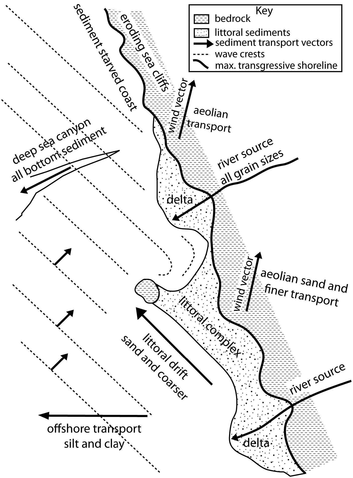
5.2 Movement of sediments along Mediterranean coasts. After Wells Reference Wells, Stein and Farrand2001: 156, fig. 6.3. Courtesy of University of Utah Press.
Coastal Landforms
The interaction of land, sea, and sky generates a wide array of coastal landforms, which in general terms can be categorized as destructional or constructional (Summerfield Reference Summerfield1991: 325–41). The destructional group is smaller, comprising mainly wave-cut cliffs and shore platforms. The constructional landforms are many and varied, including beaches, barrier islands and lagoons, estuaries and tidal features, deltas, coastal dunes, and reefs.
Coastal Cliffs and Shore Platforms
Coastal cliffs are steep, often vertical, slopes that rise above the shoreline. Fault-derived cliffs may plunge precipitously into deep water, suffering little erosion since wave energy against them is minimized by reflection of swell waves. In shallower waters, cliffs are susceptible to basal erosion by the action of breaking waves. Particularly on open coasts, wave action undercuts sea cliffs, cutting a notch around mean sea level. Over time, an overhang forms that becomes increasing unstable and eventually collapses into the sea. This material, along with other gravity-entrained colluvium from the slope, is available for reworking and transport in the littoral zone. This erosional process forms recessive shorelines: as the coastal cliffs retreat, horizontal shore platforms are left behind at the basal level where wave cutting occurred. These wave-cut or intertidal platforms are common in Greece where high wave energies combine with easily eroded limestone strata. Once formed, they are subject to weathering and abrasion. The rate of cliff erosion varies over time: in particularly stormy years, wave energy and weather can accelerate coastal erosion. If the process continues, however, eventually the cliff will be protected because wave energy is expended crossing the platform.
The sequence of shore platforms and sea cliffs may leave physical traces on land or underwater, particularly where coasts are uplifted or submerged, respectively. The Corinthia in southern Greece preserves examples of both (Hayward Reference Hayward, Williams and Bookidis2003: 16–17; Pirazzoli et al. Reference Pirazzoli, Stiros, Arnold, Laborel, Laborel-Deguen and Papageorgiou1994; Wells 2001: 173–75, fig. 6.7). The northern Corinthian plain, bordering the Gulf of Corinth, comprises a stair-stepping sequence of risers and treads that represent Pleistocene coastal cliffs and shore platforms, subsequently uplifted and subjected to faulting and erosion. Beginning in the Neolithic period, these uplifted features were attractive locations for repeated human habitation because they afforded expansive views and defensive possibilities (Tartaron et al. Reference Tartaron, Pullen and Noller2006: 496). To the east, the Corinthian port at Kenchreai on the Saronic Gulf is partially submerged as a result of approximately 2.3 meters of tectonic subsidence over the last two millennia. As many as five submerged notches, cut by wave action, dissolution, and bioerosion, have been documented in and around Kenchreai, each representing a paleoshoreline formed during a period of relative sea-level stability (Noller et al. Reference Noller, Wells, Reinhardt and Rothaus1997).
Beaches
A beach is a shore built of unconsolidated sediment (Hamblin and Christiansen Reference Hamblin and Christiansen1998: 398). Beach sediments form at the dynamic interface of land and sea, where the shoreline is constantly exposed to wave action and littoral currents. Most beaches consist of sand- or pebble-sized clasts (thus, sand or pebble beaches) because wave energy is usually sufficient to remove silt and clay from the littoral zone. Waves and currents sort beach sediments both vertically and laterally, and round and polish the clasts. These well-known processes produce a predictable set of sedimentary structures that allow the identification of fossil beach deposits (Wells Reference Wells, Stein and Farrand2001: 158, table 6.1).
Beaches are composed of both organic and inorganic material, but in Greece, carbonate pebble beaches are especially common because of the pervasive carbonate geology (limestone and other biogenic carbonates). Beachrock, intertidal sediment indurated by calcite or aragonite cement, forms readily because of the abundance of carbonate in solution in near-shore waters (Wells Reference Wells, Stein and Farrand2001: 158). Submerged or uplifted beachrock can indicate the approximate lateral positions of former shorelines, particularly in the nearly tideless Mediterranean.
The progradation of sediment seaward is sometimes manifest as sets of sandy, shore-parallel beach ridges and intervening swales. William Tanner (Reference Tanner1995) identifies four types, based on their origin. The most common are swash-built ridges, which occur where there is a constant source of sandy sediments, but longshore currents are insufficient to remove them. The sediment is instead reworked by modest storm waves (swash) into narrow mounds with low relief along the shoreline. The lower-lying surface between the new ridge and the adjacent landward ridge floods seasonally, filling with sandy near-shore sediment (e.g., backswamp or marshy deposits), thus forming the ridge-swale set.3 This is a process of gradual accretion, with each ridge representing an old beach and the ridge system marking the advance of the shoreline seaward over time. Formation can be relatively rapid, however: Tanner (Reference Tanner1995: 159–60) suggests an average interval of around 50 years for sandy swash-built ridges on ocean coasts. A striking example can be found in Greece at the mouth of the Acheron River in Epirus (Besonen et al. Reference Besonen, Rapp, Jing, Wiseman and Zachos2003: 216), where concentric accretionary beach ridges and swales have formed in historical times in an embayment well sheltered from longshore currents (Fig. 5.3).
Beach deposits can also grow outward to join with an offshore island by a narrow neck known as a tombolo. This typically occurs because the offshore island behaves as a natural breakwater, creating a wave shadow along the coast behind it, where sediment begins to build outward from the shore. Subsequently, longshore drift moves sediments onto and around the tombolo (Hamblin and Christiansen Reference Hamblin and Christiansen1998: 399; Fig. 5.4). Tombolos can enhance the natural qualities of an anchorage by creating a double-harbor configuration, and in historical times they were emulated by built causeways. The island of Mochlos off Crete's northern coast is believed to have been connected to the mainland by a tombolo in the Bronze Age (Branigan 1991: 97), and the same may have been true of the southern Cretan harbor at Kommos (Shaw Reference Shaw2006: 55).
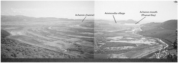
5.3 View of the sequence of ridges and swales at the mouth of the Acheron River, Epirus. Courtesy of Nikopolis Project archives.
Estuaries and Tidal Landforms
An estuary is a partially enclosed coastal body of water that communicates with the open sea, but is protected from the action of open ocean waves by its topography or some form of barrier that absorbs and refracts wave energy (e.g., sand bars or barrier islands). Usually the term is applied to inlets into which rivers or streams flow, causing fresh and marine waters to intermingle (Fig. 5.5). These transitional zones between river and ocean environments experience both marine processes (tides, waves, saline water influx) and fluvial processes (freshwater influx, sedimentation), contributing diverse nutrients that make estuaries among the world's most productive natural habitats.
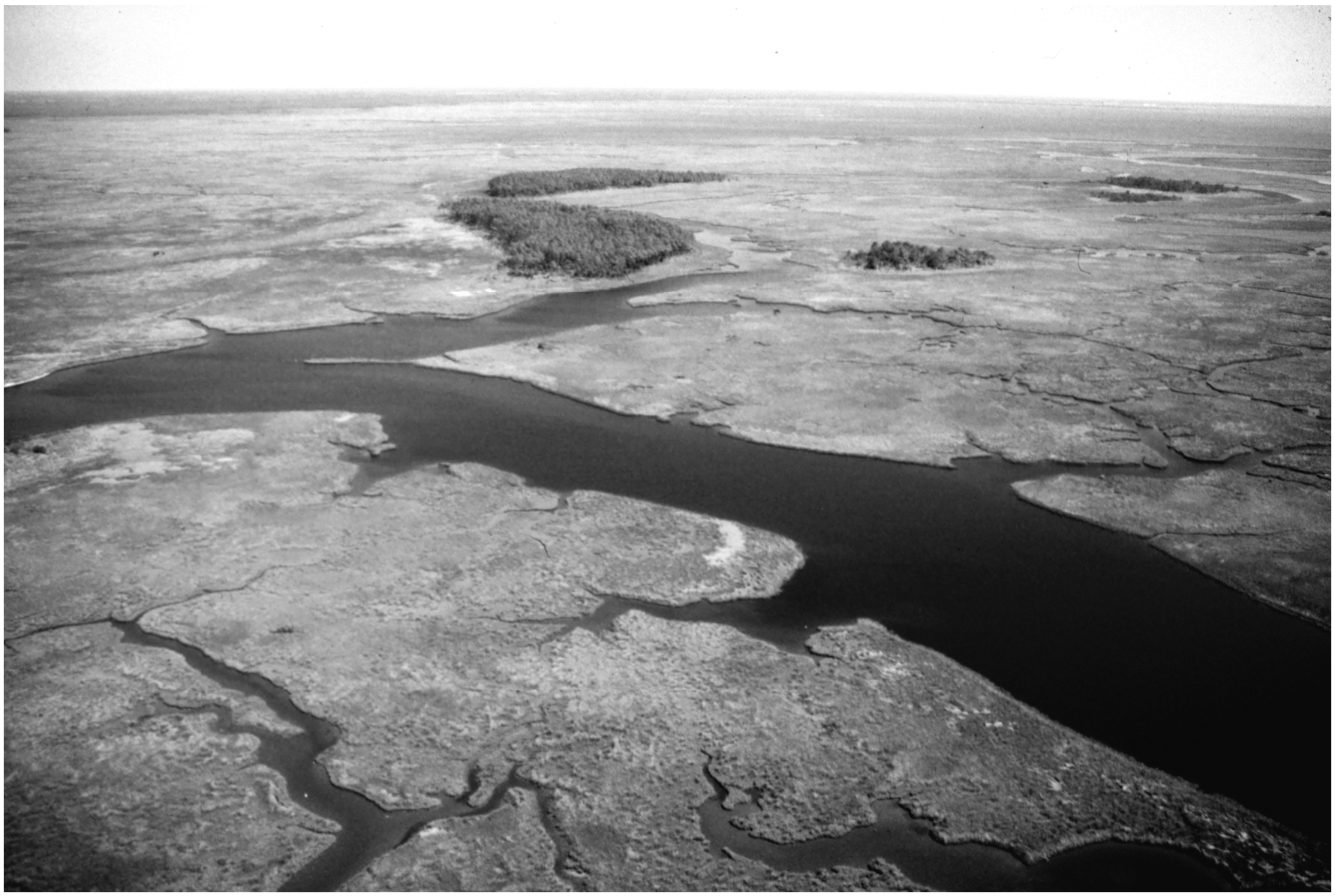
5.5 View of an estuary in South Carolina, USA. Courtesy of the National Oceanic and Atmospheric Administration.
Estuaries trap fine-grained sediments, leading to the formation of a variety of landforms such as tidal mudflats, tidal marshes and swamps, and tidal inlets. In the Aegean, where tidal currents are weak, mud and clay are deposited on shallow mudflats in the lower intertidal zone. In the upper (landward) intertidal zone, continued deposition of mud can cause vertical accretion and eventually the formation of a brackish marsh above the normal high tide level. These different landforms exhibit characteristic sedimentary structures and contents (Wells Reference Wells, Stein and Farrand2001: 158–59, 162). Mudflat sediments typically consist of a mix of silt and clay with a high iron content and in situ molluscan fauna. Tidal marshes are rich in peat, comprising very fine-grained clay and silt with a high organic content. In tectonically stable contexts, marshes build up and out, gradually infilling the estuarial basin.
Estuaries and their associated landforms are highly significant to the study of ancient coastlines. Because of their micro- and macrofossil content, as well as datable organic material, they provide key evidence for coastal evolution. Equally important is the fact that estuaries were a far more prominent feature of coastal landscapes in the Bronze Age than they are today, offering quiet environments ideal for anchorage; these would have been desirable harbor locations throughout the Mediterranean (Raban Reference Raban, Laffineur and Basch1991). Great estuaries at major river mouths are obvious targets for Bronze Age harbors, but because of the tendency of estuaries to fill in over time, smaller estuarial harbors might only be revealed by systematic geomorphological prospection.
Barrier Islands and Lagoons
Lagoons are tidal inlets of shallow marine or brackish water that are separated from the sea by a barrier. Mediterranean lagoons are typically sheltered by barrier islands, which are elongated offshore sand ridges extending parallel to the shoreline and separated from it by the lagoon (Summerfield Reference Summerfield1991: 330). Barrier islands range from a few meters in width and a few hundred meters in length to long islands a few kilometers in width and hundreds of kilometers in length. Lagoon waters are replenished by tidal inlets that perforate the barrier at irregular and migrating intervals. In response to changes in sediment supply, relative sea level, and climate, barriers may form, retreat landward, or disappear.
Lagoons fill with coarser sediment predominantly supplied by longshore drift. Because lagoons are shallow, they are susceptible to infilling and are strongly influenced by precipitation and evaporation. When evaporation rates are high, salinity in a lagoon can exceed that of the sea, and stranded lagoons can form salt pans or salt lakes. The Akrotiri Salt Lake on the southern tip of Cyprus was probably part of a lagoonal system in the Bronze Age that was later isolated from the sea (Blue 1997: 35–38). Salt deposits were surely exploited in the Bronze Age for subsistence and trade.
The western coast of the Peloponnese is a prominent example of lagoon and barrier formation. On the coast of Elis, coastal landform change has been dominated for the last 8,000 years by longshore redistribution of sediments from the Alpheios and Peneus rivers into an extensive Holocene barrier accretion and lagoonal system (Kraft et al. Reference Kraft, Rapp, Gifford and Aschenbrenner2005: 4; Fig. 5.6). In these settings, both sedimentation from fluvial inputs and erosion and littoral transport from high wave energy have shaped Elean and Messenian shorelines into long, sandy beach strands (hence, Homer's “sandy Pylos”). Hans-Jeorg Streif (1964, cited in Kraft et al. Reference Kraft, Rapp, Gifford and Aschenbrenner2005: 5) identifies three major alluvial terraces in the Alpheios River system and correlates them with three episodes of coastal barrier accretion at the delta. These are roughly dated to EBA, LBA, and Classical to modern (in several subphases).
Deltas
Deltas form where rivers deposit sediment directly into a standing body of water, such as a lake or the ocean, more rapidly than it can be redistributed by coastal processes. The sediment load deposited by deltas into seas and estuaries creates progradational complexes of river sediments reworked by littoral or estuarine processes. There are two essential components of a river delta: (1) the delta front, comprising the shoreline and the gently sloping, submerged offshore zone; and (2) the delta plain, an extensive lowland area landward of the delta front, made up of active and abandoned distributary channels fanning out over the plain (Summerfield Reference Summerfield1991: 333–36). The terrain between the channels is occupied by floodplains, levees, tidal flats, marshes, and lakes. All of these features can be recovered in a geological core, and organic material is usually available to establish a chronometric framework for the sequence.
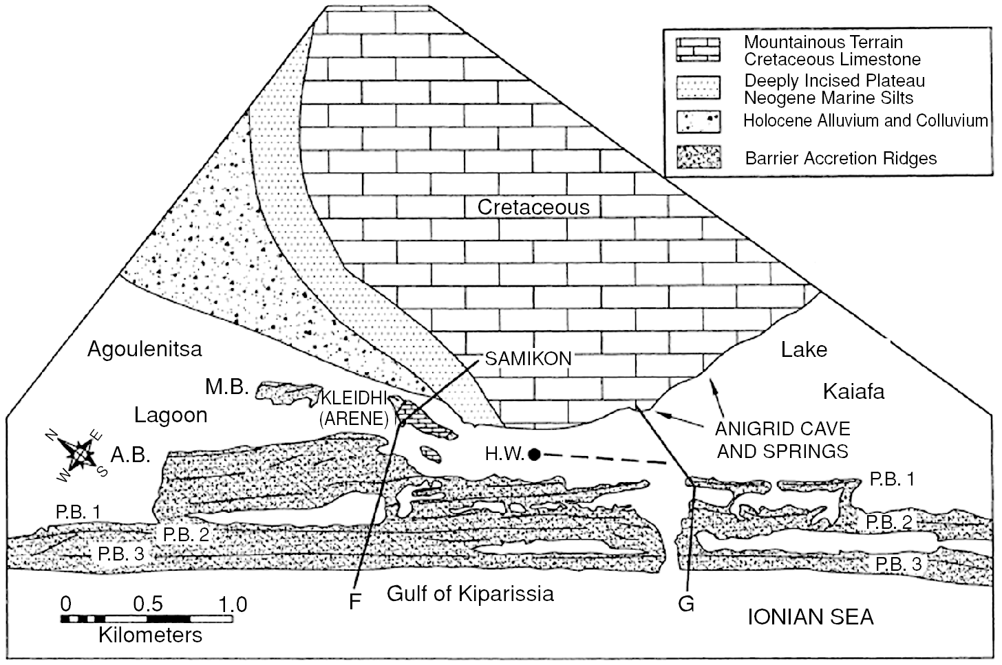
5.6 Example of a lagoon and barrier system on coastal Elis. Kraft et al. Reference Kraft, Rapp, Gifford and Aschenbrenner2005: 14, fig. 5. Courtesy of the Trustees of the American School of Classical Studies at Athens.
The structure and associated landforms of a delta depend on the interaction of the sediment-carrying stream with ocean currents and waves. Because in Mediterranean embayments, fetch – the distance wind can travel unimpeded by landforms – is limited and tidal effects are minimal, deltas are subject to limited modification by coastal processes (Summerfield Reference Summerfield1991: 333). Thus, on a continuum of delta types dominated by tides, waves, and rivers, most Mediterranean deltas are fluvially dominated (Summerfield Reference Summerfield1991: 334–35, table 13.4, fig. 13.22). Tectonic and climatic factors also play an important role in delta morphology (Summerfield Reference Summerfield1991: table 13.5). If a delta region is tectonically stable, the delta plain will aggrade as it progrades; if subsiding, it will form overlapping sedimentary lobes as it progrades; and if rising, river distributaries will cut down into and rework previously deposited sediments. Precipitation and temperature control the type and amount of the vegetation cover. Once rooted, plants trap sediments and contribute to the formation of peat.
The evolution of Mediterranean river deltas since the mid-Holocene deceleration of marine transgression has been the work of both natural and human agents. As sea-level rise slowed, river sediments began to aggrade (build vertically) and prograde (build laterally seaward) in sheltered and shallow marine embayments. Wave energy was low, and thus erosion and littoral transport were not prominent mechanisms. Instead, the deltaic material prograded gradually toward the open sea in a landscape of multiple active and abandoned river channels, distributary levees and swamps, brackish to saline lagoons, and isolated ponds or lakes ranging from saline through freshwater (Fig. 5.7). At Troy, it was only as the delta coast approached the Dardanelles that littoral currents and increased wave action deposited sands in nearshore shoals and beaches (Kraft, Rapp et al. Reference Kraft, Kayan, Brückner, Rapp, Wagner, Pernicka and Uerpmann2003: 164), and the same is true of the Maeander River, across the mouth of which a long, arcuate barrier ridge has developed in recent times (Brückner Reference Brückner, Wagner, Pernicka and Uerpmann2003). Kraft and colleagues (Kraft, Kayan et al. Reference Kraft, Kayan, Brückner, Rapp, Wagner, Pernicka and Uerpmann2003: 367, fig. 4) cite the delta of the Spercheios River, emptying into the Gulf of Malia on Greece's eastern coast, as a modern analogue where similar landforms produced by the progradation of the river delta can be observed. There, a complex landscape of meandering levees and backswamps, distributional channels, and pervasive coastal marshes has formed as the delta gradually progrades into the deep, sheltered Gulf of Malia. Because of the absence of high wave energy and littoral drift at the current delta shoreline, no coastal barriers have formed.
Coastal Sand Dunes
Coastal sand dunes can form in a range of settings, including deltas, coastal plains, and embayments. They are aeolian landforms that develop where certain conditions exist: coastlines where waves and currents interact with abundant loose, sand-sized sediments available for transport; persistent onshore or alongshore winds blowing for at least part of the year at 16 kilometers per hour or more; and flat or low-relief terrain immediately inland of the coastline (Bauer and Davidson-Arnott Reference Bauer and Davidson-Arnott2002; Martínez et al. Reference Martínez, Psuty, Lubke, Martínez and Psuty2004; Pye Reference Pye1983). Dune formation occurs when winds blow dry sand particles landward from the beach; the main sources of the sand are exposed offshore sandbars and river-mouth and other backshore sediments. Objects inland from the coast, such as plants, logs, or human constructions, interrupt the wind flow, causing sand to be deposited in drifts around them. These drifts act as barriers to sand movement, and grow over time to landforms ranging from small hillocks to vast dune systems tens of meters in elevation.
Sediment supply is the key limiting factor to dune formation. Fluvial systems are noteworthy for the large amount of sediment that they can contribute to dune formation: the Nile River has supplied sufficient sands to result in the formation of vast belts of dune ridges (El Banna and Frihy Reference El Banna and Frihy2009). In Greece, coastal dunes are common, but because of the prevalence of rocky (as opposed to sandy) shorelines and mountainous coastal topography, long, continuous costal dune systems such as are found on French or Dutch coastlines are rare. Instead, coastal dunes tend to occur in isolated embayments between promontories and cliffs, or as more extensive but discontinuous coastal dune systems, for example in the western Peloponnese or on Euboea's eastern coast (Heslenfeld et al. Reference Heslenfeld, Jungerius, Klijn, Martínez and Psuty2004: 338; Spanou et al. Reference Spanou, Verroios, Dimitrellos, Tiniakou and Georgiadis2006: 235–37, fig. 1). They tend to exist where barrier islands or wave-dominated depositional landforms occur, often as integral elements of barrier and lagoon systems (Kraft et al. Reference Kraft, Rapp, Gifford and Aschenbrenner2005).
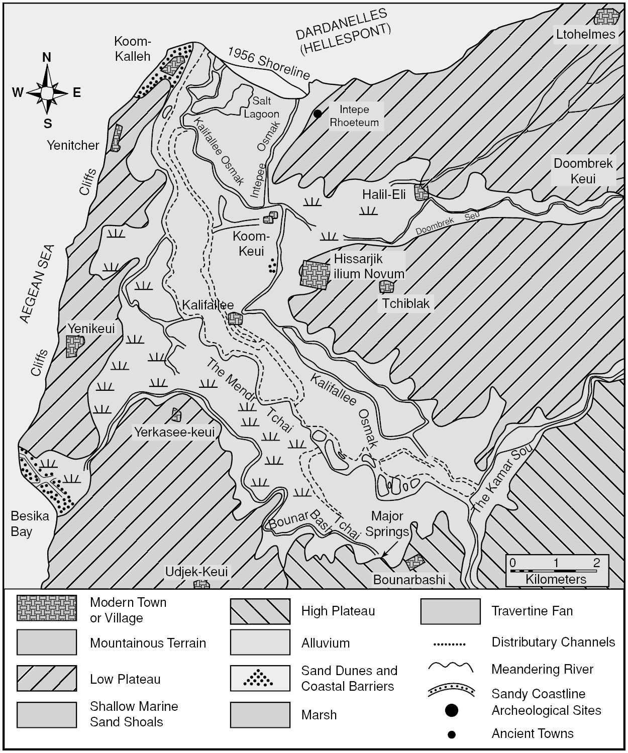
5.7 Formation of the Scamander plain, Troy. Kraft, Kayan et al. Reference Kraft, Kayan, Brückner, Rapp, Wagner, Pernicka and Uerpmann2003: 365, fig. 2. Courtesy of Springer Science+Business Media.
Coastal dunes perform several functions beneficial to the stability of coastlines and potentially to humans as well. They shield low-lying coastlines from violent storm winds and waves, and inhibit coastal erosion. They protect against saltwater intrusion into wetlands and dry lands behind them, and they support a diverse flora and fauna (Spanou et al. Reference Spanou, Verroios, Dimitrellos, Tiniakou and Georgiadis2006; Sýkora et al. Reference Sýkora, Babalonas and Papastergiadou2003). Thus, they form an integral part of coastal ecology and the resources to be found there.
The Anthropogenic Contribution
The human role in coastline formation has been conspicuous in two processes: the acceleration of sedimentation to prograding river deltas, and the creation of artificial harbors. It has long been noted that the shift to settlement in sedentary agropastoral communities in the Mediterranean coincided with mid-Holocene delta formation and shoreline progradation in the estuaries that had resulted from the late Pleistocene–early Holocene marine transgression. Human agency in soil loss – caused by stripping vegetation cover through forest clearing, agriculture, and grazing – has been implicated in increased sediment load to streams and the resulting expansion of deltas and related coastal landforms. But it is not easy to demonstrate a primary human role in this process, particularly for periods as remote as the Neolithic and Bronze Ages. There are three related problems: contemporaneity, causality, and degree of impact (Halstead Reference Halstead, Halstead and Frederick2000). The palynological, geoarchaeological, and archaeological data used to assess human impact on sediment load to coastal areas can often be dated only approximately, with the result that the contemporaneity of the impacts seen in these data sets is highly uncertain. Even when the chronological correlation is fairly secure, human causality, as opposed to a variety of climatic and other environmental changes, can be difficult to establish. Finally, the magnitude of the human impact, given the level of population and the specific activities in which communities were engaged, must be evaluated. Can it be demonstrated that Bronze Age population levels in and around coastal drainage systems were sufficiently large and their subsistence practices sufficiently destructive to account for significantly accelerated delta formation and coastline progradation?
In Greece, the most detailed documentation of putative human agency in landscape destabilization resulting in erosion and catastrophic soil loss comes from the southern Argolid. The regional surveys of the Argolid Exploration Project in the 1970s to the 1990s amassed a large body of geological and archaeological data that seemed to indicate human agency in certain episodes of massive Holocene soil erosion (Runnels Reference Runnels1995, 2000; van Andel et al. Reference van Andel, Runnels and Pope1986, 1990; Zangger Reference Zangger1994a). One of these (the Pikrodafni alluvium) was dated broadly by pottery sherds to the end of EH II, and was concentrated in valleys where FN–EH II settlement was extensive (van Andel et al. Reference van Andel, Runnels and Pope1986: 113). The Pikrodafni alluvium is dominated by debris flows: “…chaotic beds of ill-sorted, largely angular boulders, cobbles, and pebbles, surrounded and supported by a matrix of finer material” (van Andel et al. Reference van Andel, Runnels and Pope1986: 111), likely the result of sheet erosion of slopes made vulnerable to soil loss when vegetation cover was devastated by drought, fire, or clearing. Although a change of climate to drier conditions that reduce vegetation may instigate sheet erosion and result in debris flows, the investigators attributed the Pikrodafni alluvium to careless slope clearance and the “…eventual failure of EH agriculture to contain the loss of soil” (van Andel et al. Reference van Andel, Runnels and Pope1986: 117). This conclusion has been questioned on the grounds of chronological and causal ambiguity as outlined above (e.g., Bintliff Reference Bintliff, Bell and Boardman1992; Butzer Reference Butzer2005; Endfield Reference Endfield, Sinclair, Slater and Gowlett1997; Moody Reference Moody, Kardulias and Shutes1997, 2000; Whitelaw Reference Whitelaw, Halstead and Frederick2000). This debate highlights the problems and underscores the need to assess each event on its own merits before wider inferences about regional land–human relationships can be made.
In general, it is unlikely that the effect of human subsistence activities was such that large natural harbors were strongly affected in the Bronze Age, and particularly it is doubtful that humans made a greater contribution to sedimentation than the combination of climatic oscillations and natural sediment transport after the mid-Holocene stabilization of eustatic sea level. This conclusion is supported by much geomorphological research that shows that rapid infilling of major natural embayments and estuaries in the eastern Mediterranean has been a phenomenon of much more recent times (Brückner Reference Brückner, Wagner, Pernicka and Uerpmann2003: 122–25; Kraft, Kayan et al. Reference Kraft, Rapp, Kayan and Luce2003; Raban Reference Raban, Laffineur and Basch1991). On the other hand, small natural inlets and harbors based on barrier and lagoon systems must always have been more susceptible to both anthropogenically and naturally induced sedimentation (Kraft et al. Reference Kraft, Rapp, Gifford and Aschenbrenner2005), migrating and going in and out of practical use with much greater frequency.
The creation of artificial harbors in the Bronze Age Aegean is unlikely, but cannot be ruled out entirely. This kind of harbor is an artificial estuary or lagoon, where breakwaters have been constructed to reduce wave energy, creating a quiet and sheltered environment in which vessels may operate. At the same time, by minimizing the normal forces of waves and littoral currents, artificial harbors promote the net accumulation of sediment. A universal feature of artificial harbors is that they must be maintained by dredging or by some means of flushing sediment from the harbor basin. All of the processes that occur in natural estuaries also occur in artificial harbors, but they may be accelerated due to intensive human presence. Because the maintenance of harbors responds to the ebb and flow of political and economic conditions, the eventual infilling and abandonment of artificial harbors are all but inevitable (Wells Reference Wells, Stein and Farrand2001: 171).
Artificial harbors leave distinctive signatures in the geoarchaeological record, which allow them to be distinguished from natural harbors. Nick Marriner and Christophe Morhange (2007: 175–77) have identified a fairly consistent geomorphological sequence repeated throughout the eastern Mediterranean, which they term the “Ancient Harbour Parasequence” (AHP). The AHP comprises the depositional history of the harbor basin, from the natural pre-harbor state to postabandonment, with the following surfaces (boundaries) and deposits (facies):
(1) The Maximum Flooding Surface (MFS) marks the maximum marine transgression circa 6000 BP. It forms the lower boundary of the sediment archive, and laterally the farthest landward position of the coast. The deposit is characterized by coarse sand and pebbles.
(2) After 6000 BP, beach sands began to aggrade naturally, overlaying the MFS with little or no human contribution. Net sediment supply increased as the coastline prograded and the basin began to fill.
(3) The Harbour Foundation Surface (HFS) marks the incipient human modification of the basin, in the form of built harborworks, to create a sheltered harbor basin. A sharp transition from coarse beach sands to fine-grained silts and clays characterizes the sedimentology of the harbor basin. In most of the Mediterranean, this surface postdates the Bronze Age. Human exploitation of natural low-energy basins in the Bronze Age is rarely measurable on the basis of granulometry, but can sometimes be detected in subtle patterns of molluscan micro- and macrofossil assemblages (Marriner and Morhange Reference Marriner and Morhange2007: 176).
(4) The Ancient Harbour Facies (AHF) refers to the stratigraphic sequence of deposits during active use of an artificial harbor. Enhanced harbor engineering through time is evident in increasingly fine deposits (silts and plastic clays) through the Roman period, and remnants of harbor architecture (moles, breakwaters, quays, etc.), artifacts, and other anthropogenic debris are often present. The AHF may generate a diagnostic assemblage of macro- and microfauna, as well as a strong geochemical signature from human pollutants.
(5) The Harbour Abandonment Surface (HAS) records the initial (semi-)abandonment of the harbor basin, often after the Late Roman period. It corresponds to the deterioration or abandonment of maintenance of harbor infrastructure, and is marked by a transition from fine-grained harbor silts and clays to coarse sands and gravels.
(6) The Harbour Abandonment Facies (HAF) registers a return to “natural” conditions after the harborworks have deteriorated to the point that the basin is exposed to higher-energy wave action and the formation of coarse-grained sand and gravel beaches.
The Ancient Harbour Parasequence framework has been applied by this investigative group to ancient harbors including Beirut (Marriner et al. Reference Marriner, Morhange and Saghieh-Beydoun2008), Sidon and Tyre (Marriner and Morhange Reference Marriner and Morhange2006), and Marseille (Morhange et al. Reference Morhange, Blanc, Bourcier, Carbonel, Prone, Schmitt-Mercury, Vivent and Hesnard2003), and they have also fitted the geostratigraphy of other harbors, such as Caesarea Maritima (Reinhardt and Raban Reference Reinhardt and Raban1999), into this scheme (Marriner and Morhange Reference Marriner and Morhange2007: 172–74, fig. 29).
Natural versus Artificial Harbors in the Mycenaean World
As observed above, it is widely assumed that neither artificial harbor basins nor durable built harbor infrastructure existed in the Aegean Bronze Age. Centuries later, Homer and Hesiod were barely aware of artificial harbors (Morton Reference Morton2001: 106), and the image of Odysseus’ crews dragging their ships onto sandy beaches has been held up as representing standard practice in the Bronze Age. But is this really the case? Blind acceptance of the notion that all Bronze Age harbors were natural, and that ships were simply pulled up onto sandy beaches in the Homeric style (e.g., Iliad 1.485–86), has been justly criticized by Avner Raban (Reference Raban, Laffineur and Basch1991: 136) on the grounds that it has prevented investigators from looking for artificial harbor works or from accepting evidence for them. Nevertheless, to date there remains little evidence for built harbor infrastructure in the Mycenaean world. The Minoans, perhaps because of their earlier contact with Egyptian and Near Eastern seafaring societies, seem to have been more advanced in this respect. At a small number of Cretan coastal sites, large buildings divided into long, narrow galleries have been interpreted as ship sheds, used for storage of ships and nautical equipment during the winter months.4 The clearest case is the excavated Building P at Kommos (J. Shaw Reference Shaw, Hardy, Doumas, Sakellarakis and Warren1990; M. Shaw Reference Shaw, Shaw and Shaw1985; Shaw and Shaw Reference Shaw, Shaw and Tzalas1999; Fig. 5.8); at more than 37 meters long and 5.6 meters wide, the galleries of Building P could accommodate the largest of the ships depicted in the Akrotiri Flotilla Fresco (see Table 3.1). Other candidates for ship sheds include the “Shore Building” or “Shore House” at Gournia (Fotou Reference Fotou1993; Shaw and Shaw Reference Shaw, Hardy, Doumas, Sakellarakis and Warren1990: 852, n. 16; Watrous Reference Watrous2010), as well as unexcavated foundations and cuttings at Malia and Nirou Chani (Marinatos Reference Marinatos1926: 146; Raban Reference Raban, Laffineur and Basch1991: 139–40; Shaw Reference Shaw, Hardy, Doumas, Sakellarakis and Warren1990: 425–28). Elsewhere, cuttings and ruins of built features have been proposed as channels, moles, and tombolos associated with Minoan harbors (Chryssoulaki 2005; Hadjidaki 2004: 54–56). These features cannot at present be dated directly; typically, they are considered to be Minoan based on close spatial, but not stratigraphic, association with remains of Minoan buildings or artifacts. Nothing comparable has been identified on the Greek mainland.
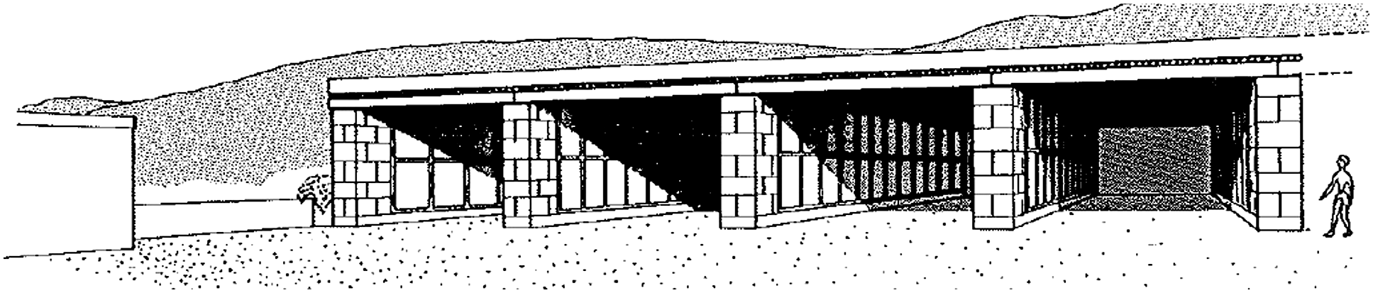
5.8 Reconstruction of ship sheds at Kommos. Shaw Reference Shaw, Hardy, Doumas, Sakellarakis and Warren1990: 425, fig. 9, drawing by Giuliana Bianco. Courtesy of the Trustees of the American School of Classical Studies at Athens.
Even the well-dated Building P is beset by interpretive issues that are crucial for the present discussion. Building P was constructed over the ruins of LM I Building J/T during pottery phase LM IIIA2, corresponding to the later fourteenth century BC. This was a time of new beginnings in the Mesara region; at nearby Ayia Triada, a megaron-style building was constructed, similar to contemporary Mycenaean megara on the mainland. A spirited debate continues on whether the Mycenaeans exercised political control over large parts of Crete during this time. If so, Building P could be a Mycenaean construction, as it has sometimes been called (Haggis Reference Haggis2003; Yasur-Landau Reference Yasur-Landau2010: 50). The excavators do not share this view, however (Shaw and Shaw Reference Shaw, Shaw, Driessen and Farnoux1997). They find no close parallel for Building P on the Mycenaean mainland, and they continue to believe that the Mycenaeans exercised neither direct political control nor extensive cultural influence over the Mesara in the Late Bronze Age. Instead, they point to iconographic evidence for the non-Mycenaean origin of the Cretan ship shed (J. Shaw Reference Shaw and Shaw1990: 429–32; M. Shaw Reference Shaw, Shaw and Shaw1985). At Akrotiri, a portion of the Flotilla Fresco on the north wall of Room 5 depicts soldiers marching to the right of a large building partitioned into narrow, open galleries facing the shore, very similar in form to Building P. The fresco at Ayia Irini on Kea depicting a seaside scene may also preserve the corner of such a building (Shaw Reference Shaw and Shaw1990: 430–31).5 The idea of an earlier Minoan tradition finds support at Gournia: on the putative ship shed there, Vance Watrous (Reference Watrous2010: 13) comments, “Similar in material, masonry, and monumental scale to the palace at Gournia, the ship-shed galleries seem to have been built at roughly the same time as the palace, probably in MM IIIA.” Thus, the Cretan ship sheds bring us no closer to definitive proof of Mycenaean built harbor infrastructure.
If the Mycenaeans did not erect built structures to enhance coastal topography, in one case at least they seem to have created an artificial harbor basin at a remove from the coastline. At Romanou near Pylos, according to Eberhard Zangger and associates, the Mycenaeans created an artificial harbor basin by means of a sophisticated hydraulic engineering project (Zangger et al. Reference Zangger, Timpson, Yazvenko, Kuhnke and Knauss1997: 619–23; Fig. 5.9). A natural depression comprising soft fossil dunes some 500 meters from the Bronze Age shoreline was widened and deepened to serve as the harbor basin. A channel approximately 40 to 50 meters wide was dug to connect this basin to a small natural cove at the coast that had probably been the original anchorage. To prevent longshore sediments from silting up the harbor basin, the perennial Selas River was diverted upstream to provide a steady flow of clean water to flush the basin. The Selas was first diverted into a lake, and from there an outlet controlled the outflow of clean overspill water, which was conducted by an artificial canal to the harbor basin. The diversion of the Selas River has been dated to the LBA by establishing the radiocarbon chronology of a sharp drop in terrestrial sediments in cores from the Osmanaga Lagoon, the natural outlet for the river prior to the diversion (Zangger et al. Reference Zangger, Timpson, Yazvenko, Kuhnke and Knauss1997: 622). The result was a sheltered and readily defensible inner harbor.
The components of this harbor virtually disappeared from the landscape once the authority that maintained it was gone; it was only recognized through a careful and expert geomorphological analysis, and to date remains the only known Mycenaean artificial harbor. Nevertheless, this approach to harbor construction is entirely in keeping with the ambitious hydraulic engineering projects at which the Mycenaeans excelled, the most prominent being the drainage and water management of the Kopais Basin in Boeotia (Knauss Reference Knauss2001), and the Kofini Dam near Tiryns (Zangger Reference Zangger1994a). The work of geomorphologists reminds us that Bronze Age coastal features, whether natural or artificial, are difficult to detect, yet it is possible to read them from the modern landscape if one is attuned to the traces they leave behind and adept in the techniques for recovering them. Although it is unlikely that many harbors as elaborate as the one at Romanou existed in Mycenaean times, this discovery does provide an example of the kind of harbor engineering of which the Mycenaeans were capable, and offers impetus to continued search for other engineered harbors.

5.9 Hypothetical reconstruction of an artificial harbor at Pylos. Drawing by Felice Ford after Zangger et al. Reference Zangger, Timpson, Yazvenko, Kuhnke and Knauss1997: 619, fig. 46.
Apart from natural harbors that were used during the Bronze Age, a variety of coastal wetlands could be exploited for diverse uses and resources. Deltas, estuaries, and lagoons are merely part of a broader series of coastal landscapes characterized by high biomass and biodiversity, which may also include lakes, bogs, river floodplains, spring-fed wetlands, and seasonally inundated dolines and poljes (Van de Noort and O’Sullivan Reference Van de Noort and O’Sullivan2006: 36–64). From such coastal settings in the Mediterranean, resources were readily available such as reeds and rushes for architectural construction; clay for pottery, mudbrick, and other architectural applications; and fish, waterfowl, amphibians, and mollusks.6 Wetlands are underappreciated as a resource for Bronze Age communities partly because in the modern world their settings are peripheral and they are rapidly disappearing through reclamation and other forms of human interference.
Geoarchaeological Methods for Reconstructing Coastal Landscapes
The investigation of ancient coastal landscapes by geoarchaeological means is a well-established tradition with a rich literature, but one that continues to evolve with technological advances and new perspectives influenced in part by recent trends in landscape archaeology, giving rise to a “theoretically informed landscape approach” (Breen and Lane Reference Breen and Lane2003: 469–70; Marriner and Morhange Reference Marriner and Morhange2007: 180). The methodology of coastal geoarchaeology involves extensive work in both the field and laboratory, and a wide range of materials as proxies for past conditions and processes. The basic principles and techniques are widely published and demonstrated by case studies (e.g., Marriner and Morhange Reference Marriner and Morhange2007; Rapp and Hill Reference Rapp and Hill1998: 75–81; Summerfield Reference Summerfield1991: 313–42, 433–55; Wells Reference Wells, Stein and Farrand2001). To be truly effective, these techniques must be performed in combination, and to realize their potential to illuminate the human past, they must be integrated with archaeological investigation.
The purpose of this section is to summarize the elements of a robust geoarchaeological investigation of a coastal landscape, following the framework outlined by Marriner and Morhange (2007; see also Brückner Reference Brückner, Wagner, Pernicka and Uerpmann2003: 125–26; Goiran and Morhange Reference Goiran and Morhange2003) that broadly divides the work between field and laboratory techniques.
Field Techniques
Geomorphological survey involves the initial mapping of coastal landforms, typically starting from maps (geological, topographic, soils), images (satellite, aerial photographs), and archaeological information (chronological, distributional) on sites and features in the coastal zone. These documents may reveal a wealth of information, and form a baseline for the research design. High-resolution satellite images and low-altitude aerial photographs often yield visual evidence for coastal landforms, such as barrier and lagoon systems, or evidence for ancient harbors, such as uplifted harbor basins or submerged harbor installations (Fig. 5.10).
Subsequent ground truthing, both on land and under water, allows natural and anthropogenic features to be studied firsthand in order to form provisional hypotheses about the morphology, genesis and developmental sequences, and chronology of coastal landforms. In many cases, landforms may be visible, for example, dune ridges, infilled lagoons, estuaries, river and stream features, beach ridges, and fossil sea cliffs, but they must be constrained chronologically and present morphologies should not be extrapolated to the past without detailed analysis. Indications of sea-level change may be apparent in submerged buildings, stranded harbor basins, wave-cut notches on fossil sea cliffs, erosion benches (platforms), and other terrestrial and underwater features. Road cuts, irrigation ditches, foundation trenches, and eroded coastal cliffs are common targets of opportunity providing windows onto past depositional and erosional sequences. There are two essential principles that must guide observations about sea-level change, however. First, the critical consideration is relative sea level; that is, the relationship between land and sea at any location is affected by erosional, depositional, and tectonic processes, and not merely by the absolute changes suggested by global or regional eustatic sea-level curves. Consequently, the second principle is that each coastal location has its own relative sea-level curve, determined by local tectonic controls as well as distinct erosional and depositional characteristics. Rapp and Kraft (1994: 73) emphasize that composite regional sea-level curves, or those borrowed from “nearby” localities, usually lead to errors in interpretation.

5.10 Aerial photograph of submerged harbor remains near Naples. Reprinted from Marriner and Morhange Reference Marriner and Morhange2007: 151, fig. 13, with permission of Elsevier.
Observations of visible coastal landforms and archaeological features often form the basis for speculation regarding the layout and date of ancient harbors. This tradition is particularly strong with respect to purported Minoan harbors on Crete (Chryssoulaki 2005; Hadjidaki 2004; Marinatos Reference Marinatos1926; Raban Reference Raban, Laffineur and Basch1991; Shaw Reference Shaw, Hardy, Doumas, Sakellarakis and Warren1990). Typically, the evidence might include artifact concentrations, foundations of Minoan-style walls extending into the sea, anchors found in the nearby sea bed, or cuttings in bedrock that cannot be dated. The arguments for the existence of these harbors often cite the prominence of Minoan seafaring in the Bronze Age (Chryssoulaki 2005; Hadjidaki 2004), an important consideration but not a directly relevant form of evidence. Thus, although reasonable hypotheses may be derived from archaeological observations and general historical arguments, little can be said with real conviction, and little detailed information can be obtained, in the absence of a full geoarchaeological assessment. Marriner and Morhange (2007: 162) cite the cautionary tale of the harbor at Kition-Bamboula on Cyprus, which two researchers depicted as a cothon based on modern engravings and field observations, before a geoarchaeological investigation revealed this to be erroneous (Morhange et al. Reference Morhange, Goiran, Bourcier, Carbonel, Le Campion, Rouchy and Yon2000).
Geophysical survey employs nondestructive techniques to detect remotely subsurface features on land and under water. In terrestrial archaeological contexts, extensive use has been made of ground-penetrating radar, magnetometry, electromagnetics, and resistivity (Kvamme Reference Kvamme2003; Sarris and Jones Reference Sarris and Jones2000). Each instrument and technique has its optimal use conditions and detection characteristics. Because harbors and other coastal features are often buried in sediment, geophysical surveys can frequently reveal the outlines of buried features, provided that their properties (magnetism, conductivity, density, etc.) contrast sufficiently with the surrounding matrix, and that they are located vertically within the detection limits of the geophysical instrument. An excellent example is the buried harbor and urban area of Portus, where Simon Keay and colleagues integrated the results of magnetometry, resistance survey, ground-penetrating radar, and electrical resistivity tomography to reveal much of the plan of Rome's principal imperial port (Keay et al. Reference Keay, Earl, Hay, Kay, Ogden and Strutt2009). These results were confirmed and expanded with programs of coring and excavation.
Comparable techniques can be used to detect features on the sea floor and buried in marine sediments beneath it, typically by towing geophysical equipment on a rig attached to a small boat. Side-scan sonar and sub-bottom profiler surveys are used to create bathymetric maps that measure depths of sediment and bedrock, giving indications of the shape and orientation of ancient harbor basins over time (Lafferty et al. Reference Lafferty, Quinn and Breen2006; Papatheodorou et al. Reference Papatheodorou, Hasiotis, Geraga, Lyberis, Ferentinos, Bassiakos, Aloupi and Facorellis2001). Marine magnetic surveys are well established and have often yielded spectacular results where underwater features with strong magnetic signals are present. A magnetic survey off the coast of Caesarea Maritima in Israel – Herod's Roman harbor – has clarified a number of questions concerning its construction and use. The magnetic data revealed the hydraulic concrete foundations for the ruined harbor moles by detecting the volcanic ash (pozzolana) in the concrete as a strong magnetic anomaly (Boyce et al. Reference Boyce, Reinhardt, Raban and Pozza2004; Fig. 5.11). These results allowed new interpretations of the shape and construction of the now-submerged outer harbor, defined by the moles and additional breakwater structures. Detected in the same survey were numerous low-relief mounds with elevated magnetic signals, on the sea bed beyond the outer harbor. These features, subsequently investigated by jet probing and excavation, turned out to be ships’ ballast piles, identified by a mixture of igneous and metamorphic boulders and fired pottery exhibiting strong magnetic properties (Boyce et al. Reference Boyce, Reinhardt and Goodman2009). It was even possible, through careful mapping and examination, to hypothesize the formation process of the ballast piles by ships anchored around a designated anchorage point (Boyce et al. Reference Boyce, Reinhardt and Goodman2009: 1524). Ballast piles associated with Bronze Age pottery have recently been discovered off the Saronic Gulf coast at Kalamianos (Tartaron et al. 2011; see Chapter 7).
5.11 Plan of submerged remains at Caesarea Maritima. From Boyce et al. Reference Boyce, Reinhardt, Raban and Pozza2004: 132, fig. 8. Reproduced with permission of Blackwell Publishing Ltd.
Geophysical techniques are nondestructive and non-intrusive, yet they can often supply rapid and reliable information about the location, depth, and nature of buried or submerged features without excavation. They may play the key role of guiding subsequent coring and excavation strategies, and more generally helping to form hypotheses and research questions. A geophysical project will more than pay for itself if it saves the investigator from a misguided research design. There are also disadvantages to geophysical surveys. There is no chronological control on the stratigraphy and archaeological features they detect, and the interpretation of anomalies often involves a high degree of subjectivity if their forms and signals are not transparently characteristic of known features. Ground truthing, in the form of excavation, coring, or other means of direct examination, is usually required to verify the identity of potential archaeological features. The entire enterprise of archaeological geophysics relies on a high level of expertise and expensive equipment that may not be easily available or affordable. Nevertheless, geophysical surveys are indispensable for the investigation of buried harbors and submarine features.
Coastal stratigraphy is the central concept of the geoarchaeological method, which entails direct observation of the geological record to locate, characterize, and reconstruct physical evidence of natural and anthropogenic processes that contribute to the long-term evolution of coastal environments. As we have seen, observations of the modern surface can be misleading or ambiguous in their relationship to the past, but all major processes that generate change (cited above) leave a record in local sediments that can be decoded by careful analysis. Ideally, one would excavate a number of sections of the vertical and horizontal dimensions of coastal and underwater sediments, but this approach is rarely feasible in terms of resources (including time and money) and permissions. Thus, geological core drilling7 is the method of choice to obtain sediment samples for analysis. The decision about where to sample and how many cores to take is a critical aspect of the research design. Although it is obvious that enhancing the resolution of the study, that is, by increasing the number of cores and decreasing the spatial interval at which they are taken, should lead to higher confidence in the results, given the usual constraints a well-rationalized sampling design is of the utmost importance. Moreover, no coring program, no matter how large or well designed, will provide all the answers hoped for, but will generate new questions that can only be addressed with further research. A perfect illustration is the decades of coring work dedicated to reconstructing the marine embayment and coastal paleogeographies of ancient Troy (Kraft, Kayan et al. Reference Kraft, Kayan, Brückner, Rapp, Wagner, Pernicka and Uerpmann2003; Kayan et al. Reference Kraft, Kayan, Brückner, Rapp, Wagner, Pernicka and Uerpmann2003). Hundreds of cores have now been taken and analyzed from the plain around Hisarlik, yet although the general outlines of the evolution of this coastal landscape are reasonably well understood, the details of interpretation continue to be debated and new questions remain to be addressed.
Many macroscopic attributes of the core sample are described in the field, using one of a number of recording systems (e.g., Folk Reference Folk1980). In the lower Acheron River valley of southern Epirus, Mark Besonen and colleagues recorded lithology, grain-size distribution, color when wet using the Munsell soil color chart, sediment consistency, plant and animal macrofossils, pedogenic characteristics (structure, sesquisoxide/reduction mottling, and calcium carbonate filaments or nodules), and chance finds such as pottery fragments (Besonen et al. Reference Besonen, Rapp, Jing, Wiseman and Zachos2003: 209). The depth of the core varies with the equipment used and the nature of subsurface layers encountered. Hand-augering is the conventional technique, because the instrument is portable and widely owned by earth science departments and private geological firms. With hand-operated equipment, it is not uncommon to reach impenetrable stony layers well before the maximum length of the auger. More elaborate power corers generally do not have this limitation (Kayan et al. Reference Kayan, Öner, Uncu, Hocaoǧlu, Vardar, Wagner, Pernicka and Uerpmann2003: 382–84), but their use is far more expensive and they may not be readily available in country. Once the attributes of the core are described, all or part of each sediment column is packed in aluminum foil or some other protective material for transport to the laboratory.
Laboratory Techniques
The core that reaches the laboratory preserves a stratified, and thus diachronic, record of the sedimentary sequence at a specific location. It is a storehouse of information, but decisions must be made about the tests that will be performed and the materials that will be tested, as well as the resolution at which the examinations are to be made. The tighter the sampling interval, the higher the resolution of the data and the better the reconstruction of coastal stratigraphy and coastal history (including chronology); Marriner and Morhange (2007: 165) recommend five centimeters or less. Time, money, and expertise for analysis are costs that should be resolved before coring begins.
After initial description of sedimentary structures, the cores are separated into subsamples to be used for analyses of different proxy materials. These analyses broadly involve sedimentology, biostratigraphy, and geochemistry.
Sedimentological analysis allows the investigator to characterize the sedimentary structures of a core sample and to identify the environmental facies that are represented in the stratified deposit.
The structural characteristics of the sediment provide important clues to the depositional environment and the source of the material that formed the deposit. Typically, subsamples are analyzed for color, grain size, microfossils, organic matter, and calcium carbonate content; organic material is extracted for radiocarbon (usually AMS) dating and sherds or other cultural material are noted (Jing and Rapp Reference Jing, Rapp, Wiseman and Zachos2003: 159, fn. 4).
Granulometry – the analysis of grain size, shape, sphericity, roundness, and sorting of clastic particles in a sediment – can indicate the mechanisms of transport and deposition and distinguish between high- and low-energy formational environments in a coastal area. Sediment texture refers in part to the range of particle sizes present; these are determined by a process of wet and dry sieving to separate the gravel-, sand-, silt-, and clay-sized fractions (Rapp and Hill Reference Rapp and Hill1998: 22–23, figs. 2.2, 2.3). These fractions are then weighed and their relative proportions are plotted graphically and statistically. The resulting ratios can indicate different kinds of coastal environments; for example, predominance of gravel and sand may indicate a fossil beach; predominant sand may indicate littoral deposits such as sandbars, barrier reefs, and islands; and predominant silts and clays may indicate an artificial harbor basin. The association between grain size distribution and paleolandform is not always straightforward, however. Rapp and Hill (1998: 38–39) identify five factors influencing grain size distribution: (1) the type of source rock and the original size of grains; (2) the type of transporting medium; (3) abrasion and solution during transportation; (4) sorting of size fractions before deposition; and (5) the depositional environment. Thus, the sources of sediment (e.g., fluvial, aeolian, longshore), the distance of transport, and the reworking of sediments in the coastal environment are some of the variables in working back to coastal paleoenvironments. Artifacts that may be present as clasts in the sand- and gravel-sized fractions are of great interest when recovered from cores.
Cores are also sampled for biogenic material, which can provide conclusive evidence for the depositional environments in which particular species lived. Biostratigraphy entails the identification of fossil organisms and the study of their temporal and spatial distribution in order to record the changing abundance and species composition, and thereby to reconstruct the depositional environments (biofacies) that these organisms characterize. The main fossil types are marine mollusks, ostracods, and foraminifera, each being both abundant in coastal waters and specific in its environmental tolerances to depth, salinity, and temperature.8 For this reason, they are excellent indicators of depositional environment and accordingly are used widely in paleoenvironmental reconstruction of coastal regions.
There are different advantages and disadvantages to these fossil types. Marine mollusks tend to be abundant, with known environmental tolerances by species. In situ shells are useful for radiocarbon dating. Mollusk shells are often the primary component of coastal middens that may be detected during archaeological or geomorphological survey. Ostracods are microcrustaceans that leave a calcite bivalve carapace, the morphological characteristics of which can provide taxonomic and phylogenetic information (Marriner and Morhange Reference Marriner and Morhange2007: 170). They tend to be ubiquitous in both fresh and marine waters, their carapaces preserve well, and because of their small size a great number can often be extracted from a core subsample. They are excellent indicators of paleoenvironment because their composition, population density, and population diversity vary as a function of water temperature, water salinity, water depth, and anthropogenic impacts (Marriner and Morhange Reference Marriner and Morhange2007: 170). As a result, ostracod species are strongly correlated with very specific depositional environments.
Foraminifera are single-celled organisms with tests divided into chambers that accumulate during growth. They are among the most ubiquitous shelled organisms, often yielding more than one million living specimens per cubic meter, and they live in all marine habitats from intertidal to deepest ocean, from tropics to poles. Their mineralized tests preserve well, so a small sediment sample is likely to provide a large and statistically valid assemblage. They do not, however, live in freshwater environments, and only a few species live in brackish contexts. Further, individual species are highly specific to environment and are quick to respond to environmental change. Thus, foraminifera are highly useful for determining a range of paleoenvironmental characteristics, including sea-level change, paleoclimate, temperature, salinity, carbonate chemistry, diet, and nutrient conditions (Marriner and Morhange Reference Marriner and Morhange2007: 170).
In the laboratory, fossil organisms are extracted and assigned to general ecological assemblages or biofacies, such as freshwater, brackish lagoon, marine lagoon, coastal, and marine. These categories are determined, as explained above, on the basis of the environmental tolerances of the species present, but also by geochemical analysis to determine the stable isotope ratios of oxygen and carbon in the shells of ostracods and foraminifera. The ratio of the two stable isotopes of oxygen, 16O and 18O, in ocean waters is a function of global evaporation rates, which in turn are proxy measures for long-term climate fluctuations as well as water temperature and salinity (for principles, see Rapp and Hill Reference Rapp and Hill1998: 104–105). This ratio is also recorded in the shells of fossil marine and freshwater organisms because the shell is formed by the precipitation of carbonates from the surrounding water. The 18O/16O ratio, expressed as variance from present mean sea water (δ18O in parts per thousand [‰]), is determined mainly by the temperature and salinity of water; negative values record progressively depleted 18O and consequently warmer and less saline water, while positive values reflect enriched 18O and colder, more saline water (Deith Reference Deith, Bailey and Parkington1988). Similarly, the ratio of the two stable isotopes of carbon, 13C and 12C, imparts information about temperature and salinity as well as the presence of carbon from decomposed plants. When stable isotope ratios are combined with the species’ ecological preferences and tolerances, the depositional environment can often be determined conclusively (e.g., Goodman et al. Reference Goodman, Reinhardt, Dey, Boyce, Schwarcz, Sahoğlu, Erkanal and Artzy2009).
The ultimate aim of geoarchaeological analysis of paleocoastal environments is to identify the changing coastal environments of deposition, or facies, over time. Facies are defined as the characteristics of a rock unit (in this case, a sedimentary deposit) that reflect the condition of its origins and differentiate it from adjacent units. Each sedimentary facies identified in the core has an essentially uniform character that reflects its origin and distinguishes it from adjacent units laterally and vertically (Rapp and Kraft Reference Rapp, Kraft and Kardulias1994: 72). Biofacies derived from microfaunal analysis are correlated with sedimentary facies resulting from the granulometric analysis (Fig. 5.12). The chronometric framework for the sedimentary sequence is usually provided by radiocarbon determinations on organic material present in the core, including shells, charcoal, wood fragments, peat, charred roots, and other plant remains. Datable sherds can also provide chronological information. When a number of sediment cores are taken across a coastal landscape, the sedimentary units can be correlated to construct a broad record of changing coastal landforms over time.
The work of Besonen and colleagues in the lower Acheron River valley provides an example of facies designations (Besonen et al. Reference Besonen, Rapp, Jing, Wiseman and Zachos2003). On the basis of geoarchaeological fieldwork using the techniques described above and others (Besonen et al. Reference Besonen, Rapp, Jing, Wiseman and Zachos2003: 209), they identified 14 distinct sedimentary facies on the modern landscape, which correlate to paleoenvironments that existed at one time or another in the Holocene (Table 5.1). They divide the facies into two broad depositional systems: the fluvial depositional system, consisting of the sedimentary environments landward of the shoreline, and the deltaic nearshore system, comprising those seaward of the shoreline but within the marine embayment (Besonen et al. Reference Besonen, Rapp, Jing, Wiseman and Zachos2003: 212–16). These data, combined with an array of radiocarbon dates from core material, allowed for the reconstruction of coastline configuration and coastal environments over time (Besonen et al. Reference Besonen, Rapp, Jing, Wiseman and Zachos2003: figs. 6.13–6.15). Because the terminology used to name these facies is not standard across the Mediterranean, it can take some effort to work out the correlations from one site to another.
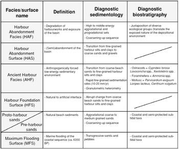
5.12 Correlation of biofacies and sedimentary facies in the Ancient Harbour Parasequence. Reprinted from Marriner and Morhange Reference Marriner and Morhange2007: 177, fig. 31, with permission of Elsevier.
Table 5.1. Sedimentary facies in the lower Acheron valley (Besonen et al. Reference Besonen, Rapp, Jing, Wiseman and Zachos2003: 213–16)
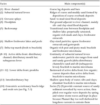
Classification of Bronze Age Harbors
Several typological schemes have been developed to classify ancient anchorages and harbors. Generally, archaeologists have offered typologies based on idealized coastal topography projected to the time of use in antiquity (e.g., Blue 1997; Chryssoulaki 2005; Raban Reference Raban, Laffineur and Basch1991; Shaw Reference Shaw, Hardy, Doumas, Sakellarakis and Warren1990), while geologists use geomorphological formation and history as the main criteria (e.g., Marriner and Morhange Reference Marriner and Morhange2007).
Lucy Blue (1997: 31–34: figs. 1, 2), basing her typology on previous work by N. C. Flemming, distinguishes two categories of Bronze Age anchorages: those on high-energy, cliff-lined coasts, and those on low-energy, low-lying coasts. Anchorages on the former occur in (1) natural bays; (2) almost enclosed bays; (3) bays on either side of an anvil-shaped headland; (4) lee of a promontory; (5) sheltered valleys; and (6) lee of offshore islands or reefs (Fig. 5.13). On the latter, anchorages are found (1) on the banks of navigable rivers that empty into the sea; (2) in inland lakes upriver; (3) in natural embayments; (4) in river deltas; and (5) in lagoons or estuaries (Fig. 5.14). Blue's typology takes into consideration not only coastal configuration and landforms but also systemic energy; her distinction between high- and low-energy environments correlates fairly well with Wells’ (2001: 150) first-order division of open versus protected coastlines. Other published descriptions of the range of Aegean or eastern Mediterranean anchorages are less detailed or are not typologies per se. Stella Chryssoulaki's (2005: 82–83, fig. V) typology is much simplified relative to Blue's and focused more narrowly on landforms rather than processes, but she does explicitly address certain features, such as sunken peninsulas and tombolos, which are particularly relevant to Minoan Crete. Using Blue's topographical typology, it is possible to assign a number of Aegean anchorages to one of her types (Table 5.2).
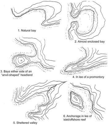
5.13 Topographic typology of Bronze Age anchorages: high-energy coasts. Drawing by Felice Ford after Blue 1997: 33, fig. 1.

5.14 Topographic typology of Bronze Age anchorages: low-energy coasts. Drawing by Felice Ford after Blue 1997: 34, fig. 2.
Table 5.2. Mediterranean anchorages associated with topographical types
Geomorphologists Marriner and Morhange (2007: 146–62, figs. 7–9) propose a complex harbor classification based on four variables: (1) proximity to the modern coastline; (2) position relative to sea level; (3) sedimentary environments; and (4) taphonomy (how a harbor came to be fossilized in the sedimentary record). According to this typology, there are buried urban, buried land-locked, buried lagoonal, buried fluvial, submerged, uplifted, and eroded harbors (Marriner and Morhange Reference Marriner and Morhange2007: fig. 7). These can further be organized as lying on unstable coasts (those exhibiting tectonic subsidence or uplift) or stable coasts (all others, not affected by tectonic activity; Marriner and Morhange Reference Marriner and Morhange2007: fig. 8). Another geomorphological perspective is preservation potential: buried harbors have good preservation potential by virtue of being buried; uplifted and submerged harbors have medium preservation potential; and eroded harbors have poor preservation potential (Marriner and Morhange Reference Marriner and Morhange2007: fig. 9).
The advantage of geomorphological typologies is that they are ostensibly based on fieldwork that has established the diachronic history of deposition, erosion, and movement of the shoreline. This is not to say that these geomorphological reconstructions cannot be misleading or wrong, as the case of Kition-Bamboula (Morhange et al. Reference Morhange, Goiran, Bourcier, Carbonel, Le Campion, Rouchy and Yon2000) demonstrates. As mentioned above, archaeological discussions of ancient coastlines that retroject modern topography into the distant past without careful consideration of geomorphological history, or that fail to present explicit evidence for proposed configurations, must be treated with caution. Blue's topographic typology is based on an understanding and application of geomorphological principles, but in the wrong hands the typology can make it seductively easy to simply match modern satellite images of coastal areas, which are so easily accessible online, with these idealized types. The topographic and geomorphological typologies are complementary data sets that should be used in combination.
A Systematic Approach to Detecting Bronze Age Harbors
The investigation of ancient harbors is by definition both a geoarchaeological problem of coastal landforms and processes, and one that requires more traditional means of terrestrial and underwater archaeology. In view of the rich geomorphological scholarship on the Mediterranean and the availability of interested coastal geomorphologists, there is no justifiable philosophical impediment to systematic, joint archaeological–geomorphological programs to detect ancient anchorages in a narrow sense, and more broadly to investigate Bronze Age coastal worlds. These investigations are interdisciplinary as is all good archaeology, and they involve terrestrial and maritime fieldwork proceeding hand in hand. There are abundant models for the implementation of pedestrian survey (e.g., Banning Reference Banning2002; Cherry et al. Reference Cherry, Davis, Mantzourani, Whitelaw, Cherry, Davis and Mantzourani1991; Tartaron et al. Reference Tartaron, Gregory, Pullen, Noller, Rothaus, Rife, Diacopoulos, Schon, Caraher, Pettegrew and Nakassis2006), terrestrial excavation (e.g., Drewett Reference Drewett1999; Hodder Reference Hodder1998), and underwater survey and excavation focused particularly on shipwrecks (e.g., Gould Reference Gould2000: 21–64; Muckelroy Reference Muckelroy1978: 24–58), but the real need going forward is for the design of programs of close collaboration between archaeologists and geoarchaeologists from inception to interpretation.
Models of integrative research, relying on constant collaboration across disciplines in the field and “intensive exchange of information, ideas, and procedures from the planning stage through final publication” (van Andel Reference van Andel and Kardulias1994: 28), are at hand in the eastern Mediterranean. The renewed excavations at Çatalhöyük by Ian Hodder and colleagues practiced a “reflexive archaeology” that assembled specialists from diverse disciplines to observe the recovery of material “at the trowel's edge” (Farid Reference Farid and Hodder2000; Hodder Reference Hodder1997, 2000). The Eastern Korinthia Archaeological Survey (EKAS) applied a comparable philosophy to pedestrian surface survey by integrating experts from all participating disciplines in each stage and in every aspect of the project (Tartaron et al. Reference Tartaron, Gregory, Pullen, Noller, Rothaus, Rife, Diacopoulos, Schon, Caraher, Pettegrew and Nakassis2006: 463–64). The fieldwork application of this philosophy entailed the “embedding” of geomorphologists in archaeological survey teams, and archaeologists with teams engaged in geomorphological mapping and soil description. The atmosphere of mutual enlightenment engendered by shared research allows collaborators to gain a realistic understanding of the opportunities, limitations, and reasonable outcomes of each others’ fields. The goal as applied to coastal research is to pool the acquired knowledge in order to learn about the human and natural interface of land and sea, in the service of a broader, more holistic study of maritime cultural landscapes; in the words of Ina Berg (Reference Berg2010: 21), “…an inclusive archaeology of islands, sea and coasts.” But, as Berg cogently emphasizes, this is not merely a matter of cross-disciplinary communication, but instead requires a commitment to breaking down the conceptual divide between land and sea that has characterized Mediterranean maritime archaeology (see Chapter 6).
Like any archaeological investigation, a joint archaeological–geomorpho-logical program of coastal research should proceed by a sequence of coherent, logical steps (Fig. 5.15). One might begin, as the present study did, with a vexing problem (where are the Mycenaean-era anchorages?), or any set of compelling, carefully defined archaeological or anthropological questions that can be applied to a geographical and chronological horizon of interest. The precise study area can be refined based on the research questions and tempered by constraints of time, money, and permit restrictions. The research questions should be formulated in an explicit theoretical framework (as we know, all archaeological research has a theoretical orientation, whether acknowledged or not), from which a series of testable hypotheses can be generated. From these preliminary deliberations, appropriate search strategies and field methods can be developed. For coastal projects, archaeological and geomorphological fieldwork may occur both on land and in/on the sea.
Strategies for the initial discovery of Bronze Age anchorages in a survey universe (a long coastline, for example) of relatively unknown site potential can make use of a host of distinctive approaches, such as the following:
(1) Investigation of known historical harbors; many have earlier histories as natural anchorages of the Bronze Age or Early Iron Age (e.g., Sidon, Tyre, Liman Tepe).
(2) Examination of modern natural anchorages to test, through geoarchaeological means, whether they existed as suitable anchorages in the Bronze Age.
(3) Focus on deltas and river mouths. Because these were favored as natural harbors in the Bronze Age, programs of geological coring may recover evidence of buried deltaic and estuarine systems of that age.
(4) Collection of information from local inhabitants, who often know of coastal and underwater archaeological sites. In addition, oral histories and archival data giving evidence of human activities in historical and modern times can provide analogies and insights into emic perceptions of maritime cultural landscapes (see Chapter 7).
(5) Intensive geomorphological and archaeological surface survey along the entire littoral zone of the study area to assess evidence for coastal landforms and to recover traces, however abundant or sparse, of human activity (with selective excavation, where possible, occurring at a later phase).
(6) Systematic search based on models of coastal exploitation. The Coasts and Harbors Survey, a subproject of EKAS, developed a GIS-driven probabilistic model for prehistoric harbor locations based on environmental and cultural variables (Rothaus et al. Reference Rothaus, Reinhardt, Tartaron, Noller, Foster and Laffineur2003; Tartaron et al. Reference Tartaron, Rothaus and Pullen2003). Ground-truthing the model resulted in the discovery of two major Bronze Age anchorages at Vayia and Kalamianos on the Corinthia's Saronic coast, and subsequent geoarchaeological investigation and archaeological prospection over the years has generally validated the principles and results of the model. In a different way, geoarchaeological analysis of the coast of Elis led to predictive statements about the locations of buried Bronze Age sites and coastal landforms (Kraft et al. Reference Kraft, Rapp, Gifford and Aschenbrenner2005). In both cases, a Bronze Age coastline has been partially reconstructed from a modern littoral virtually devoid of recognizable anchorages, a first step to reconstituting humanized coastal worlds.
Other discovery strategies, not generally practiced in the search for Mediterranean Bronze Age anchorages, are prominent elsewhere. In Scandinavia, the preferred methodological tools are phosphate analysis and place-name studies(Ilves Reference Ilves2009; Westerdahl Reference Westerdahl1992: 9–11). The method of identifying coastal settlements by detecting dark soils with high phosphate content, followed by test pitting, was established already in the early decades of the twentieth century by Olof Arrhenius (Ilves Reference Ilves2009: 154), but has been little attempted in the Mediterranean (the so-called stables at Gla are an exception: Iakovidis Reference Iakovidis1989, 2001). Similarly, the use of the many place names with transparent or plausible associations with maritime activity, as well as old maps and charters, to find harbors, is a significant element in Scandinavian maritime archaeology because of the primary focus on historical (Viking Age and later) periods. As we have seen, the names of relatively few Aegean Bronze Age settlements are known, and none has a transparent linguistic association with the coast or sea.
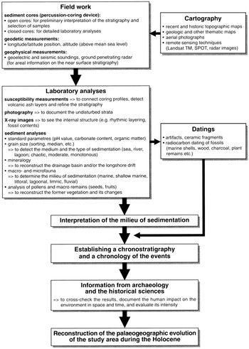
5.15 Flow chart of methods in geoarchaeology and paleogeography. Brückner Reference Brückner, Wagner, Pernicka and Uerpmann2003: 126, fig. 2. Courtesy of Springer Science+Business Media.
Liman Tepe, Aegean Turkey: A Brief Example
Recent research in the Bay of Izmir region of Aegean Turkey provides a compelling example of integrative research and a striking demonstration of the need for comprehensive geoarchaeological investigation to properly reconstruct ancient coastlines and harbors. The coastal settlement at Liman Tepe was a significant Bronze Age center, and in later times the site of the Ionian city of Klazomenai. Liman Tepe was particularly important in the EBA, when a fortified citadel was built. Finds from the limited excavations to date within the settlement have revealed a vigorous local culture with strong ties to other areas in the Aegean Islands and the Greek mainland, as shown by imported pottery as well as an architectural complex that may have functional affinities with the “corridor houses” of the EH II Aegean (Şahoǧlou 2005).
From the archaeological and historical information, it was assumed that a major harbor was located at Liman Tepe, but until the late 1990s, paleocoastal reconstructions were limited to interpretations of modern topography and the distribution of archaeological materials from surface survey. Based on information from these two sources, it was believed that in the EBA, a large part of the enclosure wall, now submerged, extended to the north and in the northwest formed a large pier with an attached built breakwater, preserved as a ruined underwater structure (Şahoǧlou 2005: 98; Fig. 5.16). It was also thought that the later Archaic-period harbor occupied a large embayment delineated by the distribution of surface and near-surface architecture and artifacts (Ersoy Reference Ersoy1993).
Because these reconstructions relied on tenuous data, a new archaeological and geoarchaeological program was begun in 1999 and continued in years following, featuring underwater excavations and a multiproxy geoarchaeological study (Goodman et al. Reference Goodman, Reinhardt, Dey, Boyce, Schwarcz, Sahoğlu, Erkanal and Artzy2008, 2009). The geoarchaeological data set was derived from terrestrial cores, sea-bed cores, and grab samples from the walls of the underwater excavation trenches. These materials were subjected to microfaunal analysis of shells, foraminifera, and other microfossils to determine presence/absence, ubiquity, and species and their environmental tolerances; grain size analysis; determination of δ18O and δ13C values relative to local sea water; presence/absence of archaeological materials; radiocarbon dating; and chronological and stratigraphic association of deposits (Goodman et al. Reference Goodman, Reinhardt, Dey, Boyce, Schwarcz, Sahoğlu, Erkanal and Artzy2008: 1270–72, 2009: 97–98). Using these proxy measures, the researchers were able to identify the following environmental facies: terrestrial, supratidal, wetland, foreshore, lagoon, upper shoreface, and artificial harbor basin (Goodman et al. Reference Goodman, Reinhardt, Dey, Boyce, Schwarcz, Sahoğlu, Erkanal and Artzy2008: 1272–77, 2009: 98–100).
5.16 Location of Liman Tepe in the Bay of Izmir region. Satellite image © 2011 Google Earth, © 2011 Digital Globe.
The historical interpretations engendered by these results conform in important ways to current understandings of long-term regional processes in the eastern Mediterranean, but explicitly contradict the previous reconstructions of the ancient coastline at Liman Tepe (Goodman et al. Reference Goodman, Reinhardt, Dey, Boyce, Schwarcz, Sahoğlu, Erkanal and Artzy2009: 100–102). The data are in basic agreement with an early Holocene marine transgression, followed by eustatic sea-level-rise deceleration circa 6000 BP. The deceleration resulted in a positive sediment budget, and excess sediments were transported by longshore currents to form sandbars, and ultimately beach barriers with extensive lagoons behind them. It was during the EBA that an ideal combination of nearshore lagoons and a tombolo joining the mainland to an offshore island created several natural, sheltered contexts to anchor or beach seafaring vessels. By the end of the LBA, however, these longshore sediments isolated the lagoons from the sea, as indicated by a change from brackish-marine to fresh water, ending the viability of Liman Tepe's harbors (Fig. 5.17). There is no evidence for a harbor of any kind for centuries thereafter, until artificial harbor constructions were first built circa 800 BC. During this Early Iron Age interim of at least 200 years, archaeological evidence indicates a diminished community with few maritime connections.
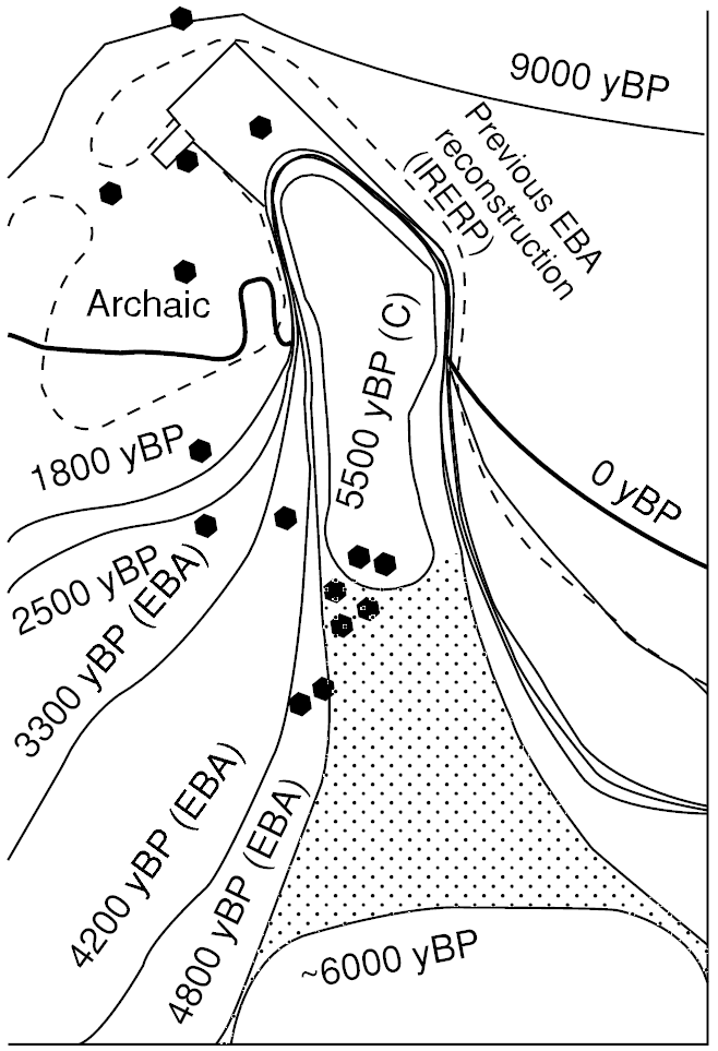
5.17 Reconstruction of the Bronze Age coastline at Liman Tepe. Goodman et al. Reference Goodman, Reinhardt, Dey, Boyce, Schwarcz, Sahoğlu, Erkanal and Artzy2009: 102, fig. 3B. Courtesy of John Wiley & Sons, Inc.
It is of particular importance that the geoarchaeological study allowed the investigators to reject the previous coastal constructions (Goodman et al. Reference Goodman, Reinhardt, Dey, Boyce, Schwarcz, Sahoğlu, Erkanal and Artzy2009: 101–103). The submerged built feature was associated not with the EBA, but with the much later built harbor of the Archaic and Classical period. This finding is significant because, along with the revelation that a number of natural anchorages existed along the EBA coastline, it helps to sustain the notion that built harbor constructions were rare or absent in the Bronze Age Aegean. Earlier reconstructions also showed a broad bay east of Liman Tepe in classical times (Ersoy Reference Ersoy1993; Goodman et al. Reference Goodman, Reinhardt, Dey, Boyce, Schwarcz, Sahoğlu, Erkanal and Artzy2009: fig. 1), but the geomorphological data demonstrate that such a bay existed only in the EBA.
The implications of these results are clear for understanding the history of the site and its maritime connectivity over time. Once again, we see that however meticulous or well intentioned, reliance on modern surface topography or archaeological patterns often leads to flawed reconstructions. Thus, the geoarchaeological study of Liman Tepe's paleocoastline offers a strong argument for the type of interdisciplinary work advocated in this chapter. Additionally, as Beverly Goodman and colleagues (2009: 103) point out, the Liman Tepe study presents a contrast to previous studies in western Anatolia focused on sites at the mouths of large rivers, such as Ephesus or Troy. It illustrates that major coastal change occurs also in less dynamic environments, even in the absence of plentiful sediment supply from an alluvial source. This point of view is especially germane as the scale of analysis moves toward finer-grained, local coastal contexts.
Conclusion
In this chapter, I have attempted to address critically the widely held impression that the land masses of the Greek mainland and Aegean Islands have been essentially stable over the period from the Bronze Age to the present. By necessity, I have emphasized the physical and environmental characteristics of coastal settings. In the next chapter, I present theoretical perspectives that emphasize the social aspects of living in coastal and maritime settings. Thereafter, the physical and social-symbolic background will be firmly in place, and the two distinct approaches can be joined in the case studies of Chapter 7.


