


INTRODUCTION
Archaeologists and architects focusing on ancient Mesoamerica have long been fascinated by the ingenious architectural program that produced the Temple of the Inscriptions at the Classic Maya site of Palenque, Mexico (Figure 1). For decades, scholars have speculated on its construction sequence and the existence of hidden rooms beneath the Temple. These rooms would be adjacent to the iconic funerary chamber where Mexican archaeologist Ruz Lhuillier (Reference Ruz Lhuillier2013) retrieved the remains of Palenque's ruler K'inich Janab Pakal in 1952.
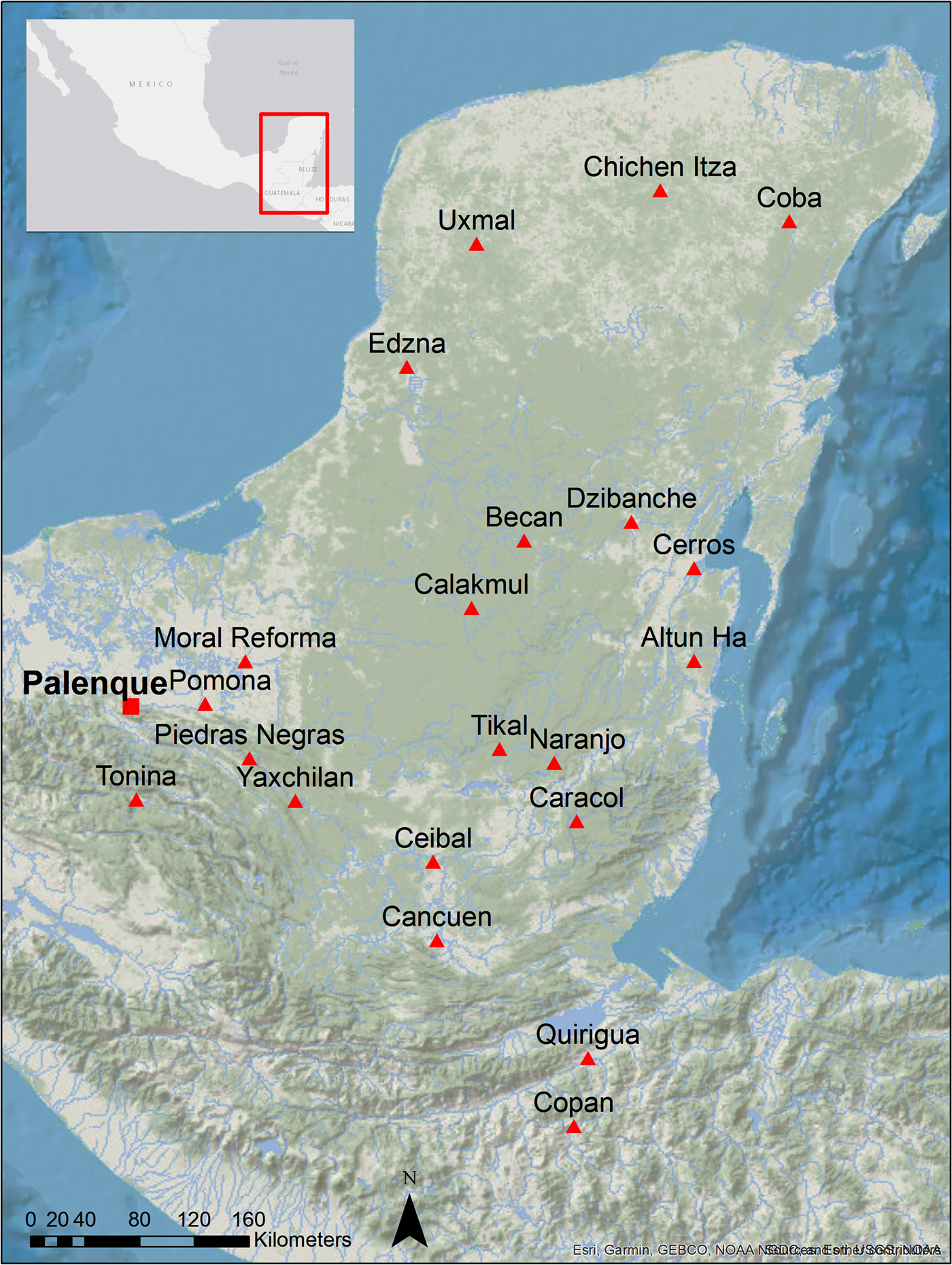
Figure 1. The ancient Maya City of Palenque (red square) and relevant contemporary Classic sites (red triangles) in the Maya Area. Map by Campiani.
Building upon the performing “datafication” approach by Richards-Rissetto and Landau (Reference Richards-Rissetto and Landau2019), this study went beyond the 3D documentation of the Temple of the Inscriptions and integrated multiple levels of archaeological information to find new answers on its construction. Our approach is significant as it combines Palenque's archaeological record and legacy 2D architectural drawings with new 3D photogrammetric and terrestrial Light Detection and Ranging (LiDAR) data to produce new interpretations of the Temple's architectural context.
We argue that the Temple of the Inscriptions was part of a larger mausoleum architectural project planned by Pakal in the seventh century. We concur that this architectural program also involved the adjacent Temple XIII, the burial place for Pakal's consort ruler Ix Tz'akbu Ajaw, the so-called “Red Queen” (González Cruz Reference González Cruz2011; Tiesler et al. Reference Tiesler, Cucina and Romano Pacheco2004), and the stepped platform building connecting the two temples. We also argue that the latter structure was utilized during the construction of the basal platforms of the temples as an entryway into the funerary chambers to perform post mortem rituals.
In the section The Buildings of The Mausoleum Architectural Project, we described all the buildings that comprise Pakal's mausoleum architectural project. In the following section, we reviewed the prior application of the metric surveying and remote sensing methods employed in this study in the Maya area, specifically Terrestrial LiDAR, also known as Terrestrial Laser Scanning (TLS), and close-range photogrammetry, or Structure from Motion (SfM; Garrison et al. Reference Garrison, Richmond, Naughton, Lo, Trinh, Barnes, Lin, Schurgers, Kastner and Newman2016; Golden et al. Reference Golden, Scherer, Houston, Schroder, Morell-Hart, del Pilar Jiménez Álvarez, Van Kollias, Talavera, Matsumoto, Dobereiner and Firpi2020; Merlo et al. Reference Merlo, Vendrell-Vidal, Fantini and Sánchez-Belenguer2012; Murtha et al. Reference Murtha, Broadbent, Golden, Scherer, Schroder, Wilkinson and Zambrano2019; Tokovinine and Estrada-Belli Reference Tokovinine and Belli2017).
We analyze the mausoleum architectural project integrating new geospatial and 3D data collected at Palenque in 2018 with its archaeological record and legacy drawings (Figure 2; Lercari et al. Reference Lercari, Campiani and Liendo Stuardo2018). This approach allowed us to observe new spatial correlations in the building's architectural levels and their substructures. To further explain these correspondences, we have carefully analyzed published literature on Palenque's mortuary practices and the associated elite funerary architecture to propose a new interpretation of the funerary chamber of the Temple of the Inscriptions (González Cruz Reference González Cruz2011; González Cruz and Balcells González Reference González Cruz, Balcells González, Golden, Houston and Skidmore2015; Greene Robertson Reference Greene Robertson2000; Ruz Lhuillier Reference Ruz Lhuillier2005; Schele Reference Schele and Benson1986; Scherer Reference Scherer2012).

Figure 2. 3D rendering of the Temple of the Inscriptions, Temple XIII, and the stepped platform building, showing the location of their substructures. Image by Campiani and Lercari.
This enhanced architectural analysis allowed us to overcome the lack of primary excavation data regarding potential hidden spaces on either side of Pakal's funerary chamber. Based on our findings, we hypothesize that, similar to Temple XX and Temple XIII, the Temple of the Inscription's substructure also follows a tripartite layout consisting of three parallel chambers oriented north-south characterized by corbelled roofs. These parallelisms support our hypothesis that the temples’ basal platforms were erected contemporaneously. Our results confirm that the Temple of the Inscriptions, Temple XIII, and the stepped platform building connecting them were part of a single monumental architectural project planned and initiated by Pakal while still alive.
THE BUILDINGS OF THE MAUSOLEUM ARCHITECTURAL PROJECT
The southwest end of Palenque's site-core is characterized by a series of aligned temples abutting against the Sierra de Chiapas (Figure 3). These include the Temple of the Inscriptions, Temple XIII, the stepped platform building lying between them, Temple XII-A, and Temple XII. Each of these constructions housed a tomb beneath its basal platform (López Jiménez Reference López Jiménez2001:128), excluding the stepped platform buildings between the Temple of the Inscriptions and Temple XIII and Temple XII-A (Figure 4).

Figure 3. The Palace (foreground) and the buildings of Pakal's mausoleum architectural project (background) are seen in a low-altitude aerial photo, abutting against the Sierra de Chiapas. Photograph courtesy of Lercari.
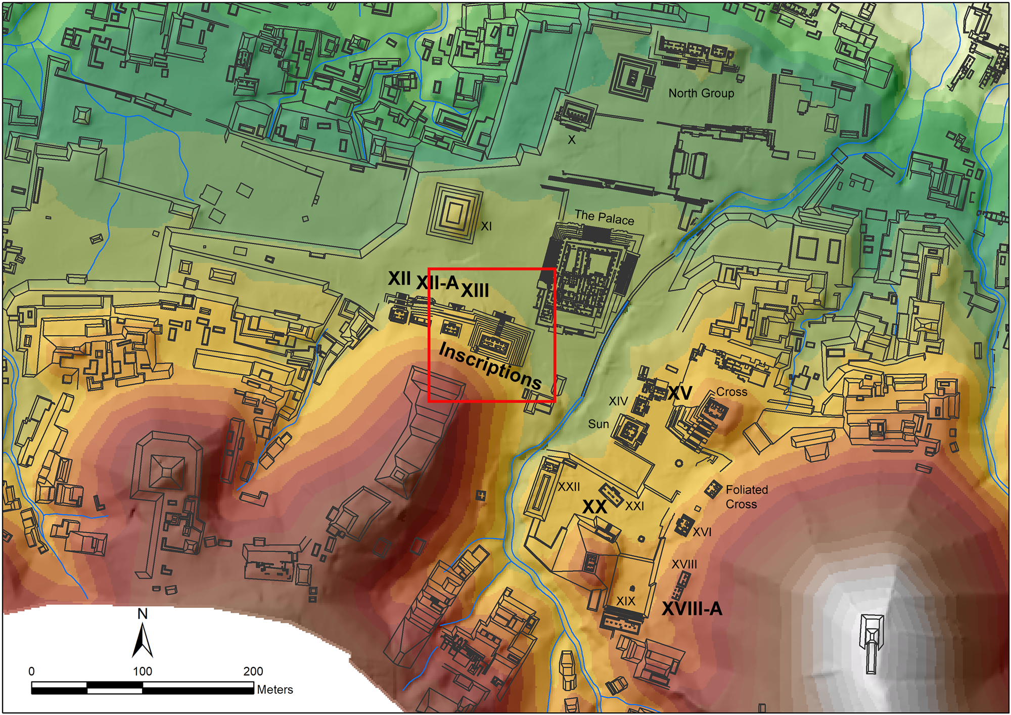
Figure 4. Palenque's site-core is seen on this map. The buildings mentioned in the text are labeled in bold font. The red square encompasses the buildings of the mausoleum architectural project. Image by Campiani, digital elevation model courtesy of Javier López Mejía, modified after Barnhart (Reference Barnhart2001).
The Temple of the Inscriptions
As the easternmost structure, the Temple of the Inscriptions is the most prominent and well-known funerary building within Pakal's mausoleum architectural project. Named after the hieroglyphic tablets found in its front and rear rooms, the Temple is supported by a rectangular, two-stepped platform sitting on top of a truncated pyramid. A north-facing façade characterizes the Temple, with five doorways separated by large piers decorated with stucco reliefs and a central stairway with large sculptured alfardas, or ramps (Andrews Reference Andrews1978:99).
The interior consists of two, parallel, gallery-like rooms oriented east-west, where the outer gallery is longer than similar structures documented at other temples at Palenque (Andrews Reference Andrews1978:107). The rear gallery, whose floor is 15 cm higher than the outer gallery, comprises three independent rooms of different sizes, among which the central one is the largest. From this room, an aperture in the floor covered by a removable monolithic slab gives access to a two-ramp stairway that descends from the Temple to Pakal's burial chamber. This architectural layout allowed the ancient Maya to perform acts of ancestor veneration until the descending shaft was intentionally filled with rubble in antiquity (Scherer Reference Scherer2012:246).
From 1949 to 1958, Ruz Lhuillier excavated the Temple of the Inscriptions. After four field seasons, he uncovered the stairway leading to Pakal's burial chamber (Ruz Lhuillier Reference Ruz Lhuillier2013). The tomb was first accessed from the stairway's end but was later shut down, and the last steps that led to that initial access were covered by a floor at a higher level, creating a corridor. At the end of the corridor, an elevated platform gives access into the chamber through a triangular door imperfectly sealed by a triangular slab (Ruz Lhuillier Reference Ruz Lhuillier2013:67). Four steps descend to an elevated landing composed of a huge slab leaning against the sarcophagus, filling the entire north-south oriented room. The chamber's soffit is remarkably corbelled by two consecutive straight vaults crossed by massive stone vault-beams (Marken Reference Marken2007; Schele Reference Schele and Benson1986). The southern vault covers the entrance, spanning from the door to the first half of the landing slab, while the higher vault represents the proper soffit of the chamber. Two rectangular cross-vaulted recesses characterize the east and west perimeter walls. The cross-vault is an architectural solution used by Maya architects to reduce the weight of the structure's roof that spanned the interior doorways of several temples and buildings (Figure 5; Marken Reference Marken2007:62; Schele Reference Schele and Benson1986:118).
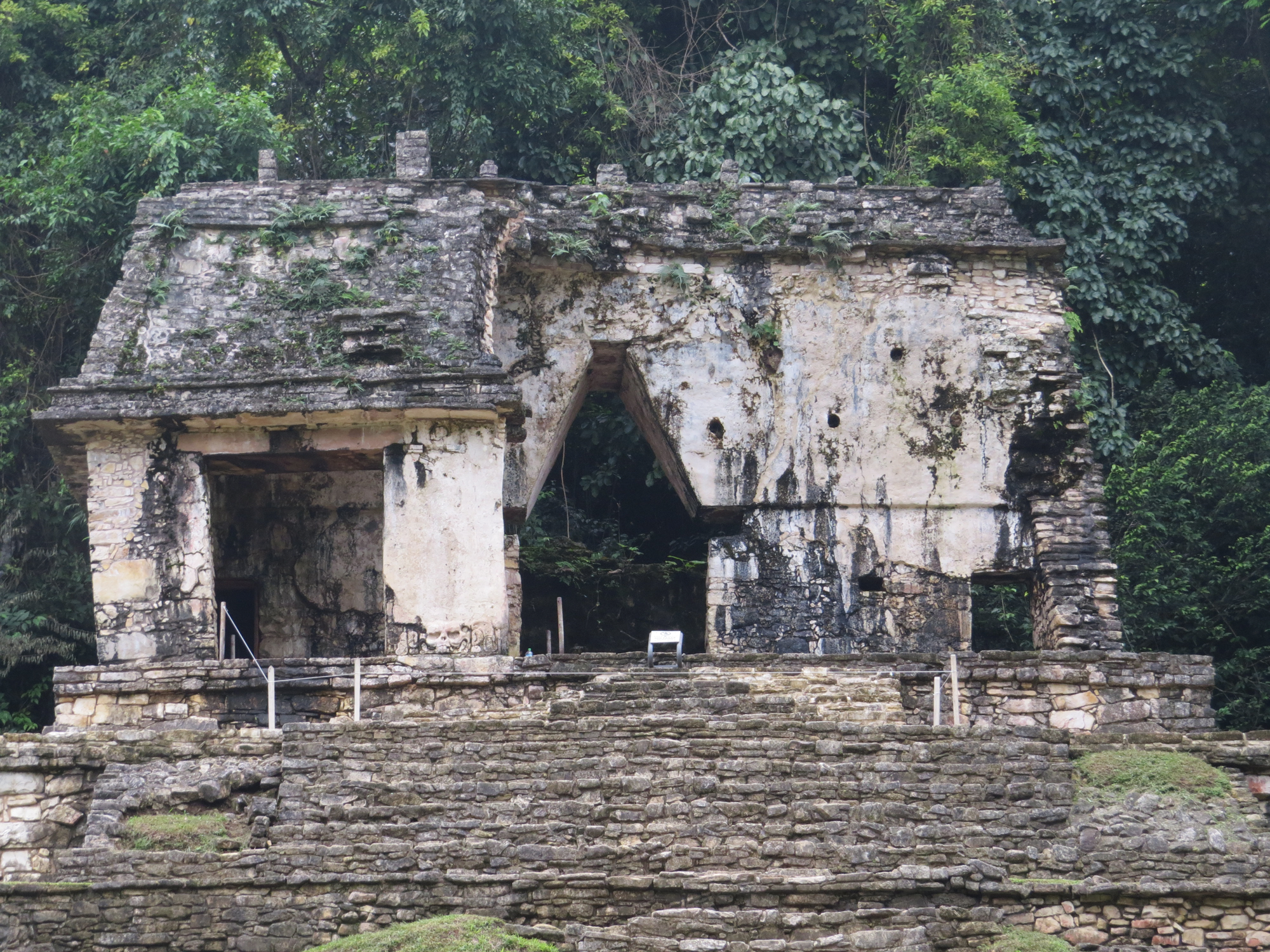
Figure 5. The cross-vault encompasses the central door in Temple XII's central wall. Photograph courtesy of Esteban Mirón Marván.
The chamber's northern wall includes a shallow niche that does not affect the end-vault unit and is interpreted as a sealed door (Loten and Pendergast Reference Loten and Pendergast1984:25). The niches and the entrance walls are decorated with stucco reliefs of nine figures similar to Temple XX's tomb's painted figures (Greene Robertson Reference Greene Robertson2000). The chamber floor, which lies below the plaza level, has a south-north inclination, and it is composed of big limestone slabs. A “psychoduct,” or an open tube-like structure or round cavity that allowed the deceased's soul to travel when called back, connects the chamber with the upper Temple (Schele Reference Schele and Benson1986:123; Stuart and Stuart Reference Stuart and Stuart2008:119). Ruz Lhuillier observed that the psychoduct seems to start from below the sarcophagus in a limestone serpent shape. It then ascends through a hollow stone tube carefully constructed on the side of the stairway, reaching the slab on the Temple's floor that gave access to the shaft (Ruz Lhuillier Reference Ruz Lhuillier2013:269; Schele Reference Schele and Benson1986:121).
The Stepped Platform Building Connecting the Temples
During his first excavation season in 1949, Ruz Lhuillier probed the structure located between the Temple of the Inscriptions and Temple XIII.
Trench 6 was meant to define the shape of the basal platform, which Ruz Lhuillier (Reference Ruz Lhuillier2013:45, authors’ translation) described as “probably attached to the pyramid and that works as the base for a small patio that separates the pyramid from Temple XIII.” The platform building connecting the temples is composed of four segments. Ruz Lhuillier described these parts as a vertical upper section and three lower partitions sloping inward, characterized by upper and basal moldings. Along with Trench 6 (Cala 6), Ruz Lhuillier (Reference Ruz Lhuillier2013:45) dug Trench 7 (Cala 7) to define the aforementioned dimensions of the small patio and uncover the west façade of the Temple of the Inscriptions.
In 1950, Ruz Lhuillier excavated the interior stairway of the Temple during his second field season. He noted two vaulted openings coming from the landing between the two ramps that seemed to extend outward in the direction of Temple XIII. In 1951, when removing the infill from the stairway, Ruz Lhuillier cleared those openings and described them as two 8-m-long narrow vaulted galleries. He interpreted the openings as ventilation windows, or respiraderos (Ruz Lhuillier Reference Ruz Lhuillier2013:62–63). These two passages open toward an earlier patio level of the stepped platform building separating the Temple of the Inscriptions and Temple XIII, almost three meters below the later patio. According to Ruz Lhuillier (Reference Ruz Lhuillier2013:62–63), the respiraderos were sealed with debris when use of the stairway leading to Pakal's tomb terminated (Rands Reference Rands1954:14).
Temple XIII
Like its adjacent buildings, Temple XIII abuts against the Sierra de Chiapas. It is composed of a stepped, truncated pyramid made of five segments, on top of which the temple proper stands on a two-stepped rectangular platform with a central stairway flanked by alfardas. The superstructure of the temple had three doors. It was found almost entirely collapsed. It consisted of two, parallel, east-west vaulted galleries, where the rear one was subdivided into three separate rooms. In 1994, while restoring the stairway at the center of the truncated pyramid basal platform, in correspondence with the second segment, González Cruz (Reference González Cruz2011:102) found a sealed door that provided access to a north-south oriented corridor inside the building. This 6-m long passage leads into another corridor that surrounds a funerary building with three chambers. The substructure stands on a 30 cm low base platform and resembles a temple building: its exterior exhibits medial molding on three sides. The southern façade has not yet been excavated. This medial molding is part of the vault spring for the corridor's roof. As observed at several other Palenque-style temples, the medial molding corners consist of huge square limestone slabs that support the roof's infill (Andrews Reference Andrews1978:13; González Cruz Reference González Cruz2011:104). While the façade of the funerary building has an east-west orientation, the main axis for the three inner chambers is north-south. The central chamber, which was found sealed, hosts the sarcophagus of the Red Queen, a monolithic limestone block painted red on its four sides and closed by a huge limestone slab where the red painting had faded away (González Cruz Reference González Cruz2011:116). The presence of a tiny round cavity (3.5 cm diameter) that goes through this slab has been interpreted as a psychoduct (González Cruz Reference González Cruz2011:117). The chamber's south wall encloses a few steps leading to a central door, sealed from the outside. Even if it is not clear to where this door leads, González Cruz (Reference González Cruz2011:113) argued that it was the chamber's main entrance. Four additional sealed doors leading to the outside are also found in the corridor. This passage is characterized by an inverted C-shape layout, surrounding the substructure. Two doors are located at the end of its east-west section, while the other two are at its southern edges. When the first doors were excavated, it was observed that these were passageways ascending with ramps toward the main plaza (González Cruz Reference González Cruz2011:117, 125). The other two southern doors also appeared to give access to passageways leading toward the surface. During their excavation, González's team tried to find access to these passageways from the outside. The test pits sounding the seventh segment of the basal platform, however, were too dangerous to excavate. Therefore, the archaeologists could not determine whether the passageways reached the basal platform's seventh segment or to where they led (González Cruz Reference González Cruz2011:112).
BACKGROUND ON THE APPLICATION OF 3D DOCUMENTATION METHODS IN THE MAYA AREA
This section reviews the metric surveying and remote sensing methods employed in this study to provide readers with a background on the prior application of these 3D technologies in the Maya area.
In the last decade, the increasing availability of airborne LiDAR technology, also known as Aerial Laser Scanning (ALS), has revolutionized the archaeological investigation of Mesoamerica's densely forested regions. ALS enables remote measurements of the underlying elevation of the Earth's surface and human-made structures on the landscape. This capability produces detailed topographic data for mapping and site reconnaissance purposes or investigating land use and landscape modification in antiquity (Canuto et al. Reference Canuto, Estrada-Belli, Garrison, Houston, Acuña, Kováč, Marken, Nondédéo, Auld-Thomas, Castanet, Chatelain, Chiriboga, Drápela, Lieskovsky, Tokovinine, Velasquez, Fernández-Diaz and Shrestha2018; Chase et al. Reference Chase, Chase, Weishampel, Drake, Shrestha, Clint Slatton, Awe and Carter2011, Reference Chase, Chase, Awe, Weishampel, Iannone, Moyes, Yaeger and Brown2014; Hare et al. Reference Hare, Masson and Russell2014; Inomata et al. Reference Inomata, Pinzón, Ranchos, Haraguchi, Nasu, Fernandez-Diaz, Aoyama and Yonenobu2017, Reference Inomata, Triadan, Pinzón, Burham, Ranchos, Aoyama and Haraguchi2018, Reference Inomata, Triadan, Vázquez López, Fernandez-Diaz, Omori, Bauer, Hernández, Beach, Cagnato, Aoyama and Nasu2020; Opitz Reference Opitz, Forte and Campana2016; Opitz and Cowley Reference Opitz, Cowley, Opitz and Cowley2012; Reese-Taylor et al. Reference Reese-Taylor, Hernández, C, Esquivel, Monteleone, Uriarte, Carr, Acuña, Fernandez-Diaz, Peuramaki-Brown and Dunning2016; von Schwerin et al. Reference von Schwerin, Richards-Rissetto, Remondino, Spera, Auer, Billen, Loos, Stelson and Reindel2016).
Despite its wide adoption in studying the ancient Maya landscape, ALS is not the most suitable metric survey technique for documenting archaeological excavations and buildings at the intrasite level (Boardman and Bryan Reference Boardman and Bryan2018; Lercari Reference Lercari, Forte and Campana2016; Vosselman and Maas Reference Vosselman and Maas2010). Alternative close-range LiDAR techniques, such as TLS, are much more effective in delivering ultra-precise measurements of the morphology of stratigraphic layers (Doneus and Neubauer Reference Doneus, Neubauer, Baltsavias, Gruen, Gool and Pateraki2005b; Galeazzi Reference Galeazzi2016) and high-fidelity 3D point representations of archaeological surfaces and built structures (Forte et al. Reference Forte, Dell'Unto, Issavi, Onsurez and Lercari2012; Lercari Reference Lercari2019). Most significantly for Maya archaeology, TLS is capable of recording building substructures uncovered through tunnel excavations and capturing with millimeter-level accuracy archaeological features retrieved in caves, buildings, and plazas (e.g., stucco masks and friezes, hieroglyphic panels, and stelae; Galeazzi Reference Galeazzi2016; Golden et al. Reference Golden, Scherer, Houston, Schroder, Morell-Hart, del Pilar Jiménez Álvarez, Van Kollias, Talavera, Matsumoto, Dobereiner and Firpi2020; Merlo et al. Reference Merlo, Vendrell-Vidal, Fantini and Sánchez-Belenguer2012, Reference Merlo, Aliperta and Montuori2017; Tokovinine and Estrada-Belli Reference Tokovinine and Belli2017). Besides allowing building monitoring overtime (Kováč et al. Reference Kováč, Desprat, Gayol, Hulínek, Bonatz and Kováč2015; Vidal Lorenzo et al. Reference Vidal Lorenzo, Cosme, Merlo and Ippolito2017), 3D data provide the basis for the virtual reconstruction or reassembling of monuments in GIS and virtual reality (Remondino et al. Reference Remondino, Gruen, von Schwerin, Eisenbeiss, Rizzi, Girardi, Sauerbier and Richards-Rissetto2009; Richards-Rissetto et al. Reference Richards-Rissetto, Jim Robertsson, von Schwerin, Remondino, Girardi, Earl, Sly, Chrysanthi, Murrieta-Flores, Papadopoulos, Romanowska and Wheatley2013).
Since the 2010s, drone-based SfM has proven very effective in documenting entire excavations and enabling low-cost investigation of the archaeological built environment and landscape (Fernández-Hernandez et al. Reference Fernández-Hernandez, González-Aguilera, Rodríguez-Gonzálvez and Mancera-Taboada2015; Fernández-Lozano and Gutiérrez-Alonso Reference Fernández-Lozano and Gutiérrez-Alonso2016; O'Driscoll Reference O'Driscoll2018; Verhoeven Reference Verhoeven2011; Waagen Reference Waagen2019; Wernke et al. Reference Wernke, Adams and Hooten2014). In the Maya area, due to the dense forest canopy covering most archaeological sites, the applicability of drone-based documentation techniques is more efficient in deforested zones (Murtha et al. Reference Murtha, Broadbent, Golden, Scherer, Schroder, Wilkinson and Zambrano2019) or where the vegetation has been partially cleared (Lercari et al. Reference Lercari, Campiani and Liendo Stuardo2018).
Most significantly for this study, LiDAR and SfM data can be successfully combined in the same analytical environment to contextualize ancient buildings and relate them to their immediate surroundings (Holata et al. Reference Holata, Plzák, Světlík and Fonte2018; Lambers et al. Reference Lambers, Eisenbeiss, Sauerbier, Kupferschmidt, Gaisecker, Sotoodeh and Hanusch2007; Nex and Rinaudo Reference Nex and Rinaudo2011; Smith et al. Reference Smith, Passone, al-Said, al-Farhan and E. Levy2014). This data fusion technique also enables a new way to investigate ancient structures from different perspectives, generate drawings extrapolated from the 3D models, and spatially relate archaeological findings (Houston et al. Reference Houston, Newman, Román and Garrison2015; Vidal Lorenzo et al. Reference Vidal Lorenzo, Cosme, Merlo and Ippolito2017).
METHODS
The long history of archaeological research at Palenque has generally focused on the ancient city's central sector. Most of the restored structures visible today are related to civic spaces where many ceremonial activities were performed. The public nature of these spaces suggests that ceremonial activities would have been highly relevant for most people who lived within and beyond the city limits (Liendo Stuardo et al. Reference Liendo Stuardo, López Mejía, Campiani, edited by Tsukamoto and Inomata2014). To enhance interpretation, we have carefully analyzed Palenque's mortuary practices and the associated elite funerary architecture. We focused on the Temple of the Inscriptions, Temple XII, Temple XIII, Temple XVIII-A, and Temple XX, where archaeologists have recovered remarkable mortuary contexts.
Our methodology combines the analysis of legacy data documenting the structures listed above with TLS and SfM data, collected at Palenque in 2018.
The digital methods presented herein allowed us to enhance our architectural analysis of the case study by adding 3D layers of archaeological and architectural information to the plans, elevations, and cross sections made available by previous excavations. We utilized this wealth of information to visually superimpose and inspect their construction phases and substructures (Figure 6).

Figure 6. Composite visualization of the northern façades of the Temple of the Inscriptions, Temple XIII, and the stepped platform building and their substructures. Structure from Motion 3D models (color) are seen superimposed with a Terrestrial Laser Scanning 3D model (solid light gray) and architectural drawings (thin white lines). The elevations of Temple XIII's inner chambers were digitized from González Cruz Reference González Cruz2011. Image by Campiani and Lercari.
Surveying the Temple of the Inscriptions through Terrestrial LiDAR and SfM
Our architectural analysis of the Temple of the Inscriptions is grounded in new remote sensing data collected by TLS and drone-based SfM (Figure 7).

Figure 7. Perspective 3D render displaying Pakal's mausoleum architectural project buildings. Image by Campiani and Lercari.
To produce the hyperprecise 3D point clouds (sets of measurements defined by X, Y, and Z coordinates) of the Temple of the Inscriptions, we needed to compare this building's architectural level and its substructures with those of nearby Temple XIII. We adapted proven TLS surveying and data processing workflows to our case study (Doneus and Neubauer Reference Doneus and Neubauer2005a; Olsen Reference Olsen2015; Olsen et al. Reference Olsen, Kuester, Chang and Hutchinson2009). Accordingly, we laser scanned the building on top of the Temple of the Inscription's basal platform recording its external walls with the sculpted figures on the ramps and the stucco reliefs on the external piers. We have also used TLS to document its interior, including the famous limestone tablets (Maudslay Reference Maudslay1887; Ruz Lhuillier Reference Ruz Lhuillier2013:29–41), shafts, and underground spaces (Figures 8 and 9).

Figure 8. The Temple of the Inscriptions' interior and Pakal's funerary chamber (light gray) and the Temple's exterior and its basal platform (transparent gray) are seen in this perspective 3D render. Image by Lercari and Campiani.

Figure 9. The shaft providing access to Pakal's tomb, the target spheres, and paper targets used as control points in our 3D survey. Photograph by Campiani.
To contextualize the Temple of the Inscriptions within the mausoleum architectural project, we conducted a metric survey of the entire site-core. We utilized low-altitude photographs collected through a DJI Inspire 1/RAW drone equipped with a Zenmuse X5 RGB camera and SfM methods. Using these methods, we overcame the challenges of mapping Palenque's city center from the ground where the tropical vegetation and the numerous visitors flocking the site during the time we were in the field would have made this task more time-consuming and less precise.
To georeference the individual TLS scans and align the Temple's comprehensive point cloud with the site-core's SfM data, we utilized a standard topographic survey workflow based on triangulation by a total station (DiBiase Reference DiBiase1997). Because no permanent control network is available at the site, we followed a conventional method that involves setting the primary project datum point to an arbitrary coordinate (Schneider and Panich Reference Schneider and Panich2008). In this way, we recorded our temporary ground control points for both the TLS and SfM surveys.
To align our grid with the site map, we recorded several known architectural elements of buildings throughout the site-core that are recognizable in Barnhart's (Reference Barnhart2001) plan. Finally, we converted our local coordinates to WGS84 (Figure 10).
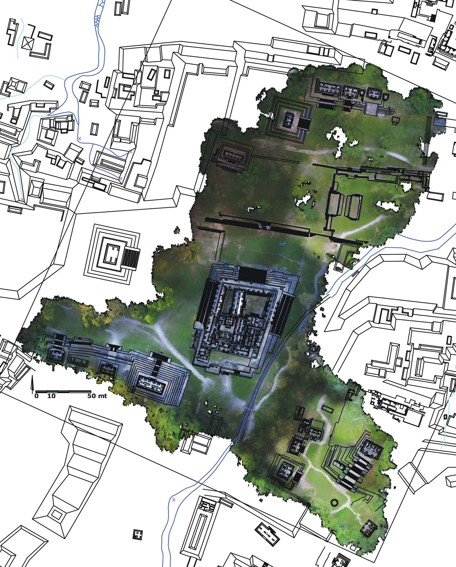
Figure 10. Orthomosaic of Palenque's site-core generated using drone-based Structure from Motion (SfM) overlapped with Palenque's map. Image by Campiani, modified from Barnhart (Reference Barnhart2001).
Enhancing Architectural Analysis through Datafication
To complete our architectural analysis of the Temple of the Inscriptions and Temple XIII, we integrated the heterogeneous corpus of accessible data. This collection includes the buildings' published architectural maps and our team's 3D data (Andrews Reference Andrews1978; Barnhart Reference Barnhart2001; González Cruz Reference González Cruz2011; Ruz Lhuillier Reference Ruz Lhuillier2013).
The data were combined using a computer-aided design (CAD) environment: the ground control points coordinates were precisely plotted on Barnhart's map using the known visible architectural elements and the orthomosaic obtained from digital photogrammetry. Once both the orthomosaic and the chamber's image were situated on Barnhart's map, we digitized the burial chamber's layout and the inner stairs' silhouette showing the respiraderos' location. We then outlined the patio of the stepped building platform lying between the Temple of the Inscriptions and Temple XIII.
To identify the possible correspondence of architectural phases, we needed to consider the buildings in three dimensions and, thus, count on longitudinal and transversal cross sections of the façades of both the Temple of the Inscriptions and Temple XIII. We generated this architectural analysis material directly from the 3D models: the point clouds of the Temple of the Inscription were triangulated in MeshLab (Cignoni et al. Reference Cignoni, Callieri, Corsini, Dellepiane, Ganovelli, Ranzuglia, Scarano, Chiara and Erra2008) then exported as a triangular mesh 3D model. We then imported this 3D dataset and the mesh generated via the SfM into the 3D modeling software Blender. Using this application, we confirmed that the 3D models overlapped completely. By applying transparency effects and Boolean operations in Blender, we sliced the two models, observed the relations between the buildings and their construction levels, and finally imported orthogonal drawings and cross sections into the CAD environment.
To complete the architectural analysis of Temple XIII, we relied on the elevation, plan, and cross section drawings published by González Cruz (Reference González Cruz2011). We also utilized the 3D data of Temple XIII generated through SfM to locate substructures where the Red Queen was buried. Specifically, we overlapped González's elevation drawing with the photogrammetric orthogonal front image of Temple XIII. Then we used the access door as a guide to locate the funerary chamber, both in plan and elevation. We finally digitized architectural drawings from both temples and overlapped them in CAD with an orthomosaic of the south-west end of the site-core generated via SfM (Figure 11).

Figure 11. Digitized architectural drawings (red lines) of the Temple of the Inscriptions’ and Temple XIII's tombs. The drawings are seen in CAD overlapped with a section of the orthophoto of Palenque's site-core. Temple XIII's inner chambers' plans digitized from González Cruz Reference González Cruz2011. 3D models and drawings by the Campiani and Lercari.
RESULTS
Following Richards-Rissetto and Landau (Reference Richards-Rissetto and Landau2019:122), we performed datafication through the following steps: (1) reanalysis of Palenque's archaeological record; (2) digitization of the original drawings of Pakal's mausoleum buildings; (3) integration of these legacy data with the 3D data we collected in 2018; and (4) enhanced architectural analysis.
Specifically, we identified three possible scenarios related to the construction of the Temple of the Inscriptions. Two of the hypotheses presented in the following pages were proposed earlier by other researchers investigating Palenque. In contrast, the third hypothesis originates from the architectural analysis informed by our geospatial and 3D data.
Previous Hypotheses on the Construction of the Temple of the Inscriptions
Ruz Lhuillier (Reference Ruz Lhuillier2013) and Schele (Reference Schele and Benson1986) proposed the first hypothesis regarding the Temple of the Inscriptions' construction. According to their interpretation, the Temple and Pakal's tomb were part of the same architectural program. Because of the size and mass of the Temple's basal platform, this hypothesis suggests that the sarcophagus inside the chamber was positioned and sculpted in situ and protected by walls and sand during the construction of the surrounding room and its corbelled vault.
Schele (Reference Schele and Benson1986:120) went even further and suggested that Pakal would have supervised his tomb's construction and decoration firsthand. She also stated that the tomb's layout would have emulated the Early Classic tomb of Temple XVIII-A. According to the vessels deposited in the cist, Rands situated the burial exposed in Temple XVIII-A in the Early Classic period (a.d. 400–600; Schele Reference Schele and Benson1986:115). She suggested that the male individual buried in this tomb could have been Ahkal Mo' Nahb' I (called in the article Chaacal I), one of Palenque's ruling dynasty's founders (Schele Reference Schele and Benson1986:116). This individual is mentioned in the Temple of the Inscriptions' epigraphic record and represented on the lid of Pakal's sarcophagus.
Nonetheless, recent radiocarbon dating performed by Couoh Hernández and Cuevas García (Reference Couoh Hernández and Cuevas García2015) readjusted the dating for this individual to a.d. 250–420. This new evidence dates the burial to a period predating the foundation of Palenque's dynasty, therefore confuting Rand's initial interpretation. Whoever was buried in Temple XVIII-A, his tomb's layout is evocative of the later funerary chambers unearthed on-site.
Of note for our architectural analysis, the tomb's major axis is north-south, with the burial's head oriented to the north. The vaulted-roof chamber was accessible through a stair from an outside platform, and large, single slabs sealed the door. Previous excavations documented a vertical stone tube emerging from Temple XVIII-A and reaching the tomb's upper sanctuary floor. This tube is undoubtedly an early example of a psychoduct that ancient Maya architects decided to preserve when they erected the Late Classic Temple XVIII-A on top of the earlier structure hosting the tomb, even if the stone tube remains 50 cm below the new floor.
Recent investigations of the Early Classic tomb in Temple XX unveiled another example of funerary architecture denoting a tripartite layout (González Cruz and Balcells González Reference González Cruz, Balcells González, Golden, Houston and Skidmore2015). The corbelled main chamber also follows a north-south orientation. The doors of the two lateral chambers were sealed with large stone slabs. We believe that the similar layout of each tomb supports our claim regarding a preferred tripartite scheme used in elite burials at Palenque during the Classic period.
Cedillo Álvarez and Villalobos Pérez (Reference Cedillo Álvarez, Villalobos Pérez and Cobos2004) formulated the second hypothesis on the construction of the Temple of the Inscriptions. They suggested that the mausoleum was built on top of an earlier temple lying on a low platform. After analyzing the architecture of early temples at Palenque, they suggest that this earlier temple building resembles the Temple of the Count and would have been composed of two parallel, gallery-type rooms oriented east-west. The corridor to the rear, located underneath the central cross-vault, would have been selected to place Pakal's funerary chamber (Cedillo Álvarez and Villalobos Pérez Reference Cedillo Álvarez, Villalobos Pérez and Cobos2004:105, 120, Figure 14). According to Cedillo's and Villalobos’ hypothesis, there should be a hidden room on each side of Pakal's funerary chamber. These lateral rooms should correspond to the proper east-west gallery-type rooms of the earlier temple.
New Findings and Interpretations Informed by 3D Data and Architectural Analysis
As mentioned previously, we utilized architectural analysis informed by new geospatial and 3D data to go beyond the two scenarios discussed above and support our argument regarding the Temple of the Inscriptions being part of Pakal's mausoleum architectural project. Specifically, we used new 3D data describing the Temple of the Inscriptions, Temple XIII, and their substructures, along with the stepped platform building connecting them, to compare their architectural levels.
Our findings emphasize striking spatial correspondences that have not been observed before. For instance, we have detected that the level of the tomb of the Red Queen is the same as the earlier level of the central stairway of the Temple of the Inscriptions, lying 2.75 m above the plaza (Andrews Reference Andrews1978:99; Ruz Lhuillier Reference Ruz Lhuillier2013:99).
Using Ruz Lhuillier's (Reference Ruz Lhuillier2013:102) excavation data locating a containment wall to the east of the Temple's basal platform and Rands’ (Reference Remondino, Gruen, von Schwerin, Eisenbeiss, Rizzi, Girardi, Sauerbier and Richards-Rissetto1954) ceramic analysis that attributes this wall to an earlier construction phase, we inferred that this level corresponds to a natural terrace that extended continuously from the center of the eastern part of Temple of the Inscriptions’ façade through at least the Red Queen's funerary chamber (Figure 12).
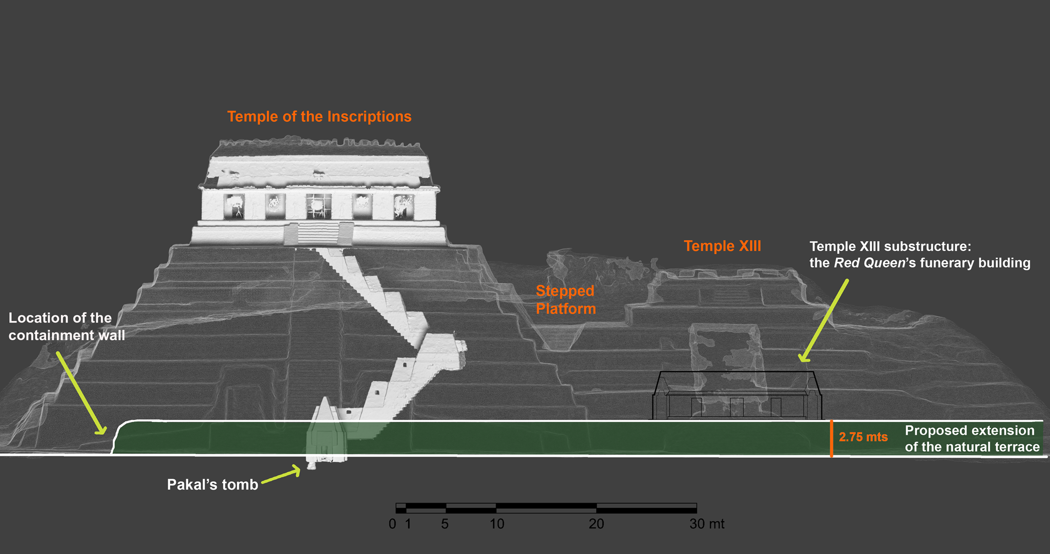
Figure 12. Composite visualization of the northern façades of the Temple of the Inscriptions and surrounding buildings. The integration of 3D renders and digitized drawings highlights the natural terrace (green area) beneath the buildings. Temple XIII's inner chambers' elevation digitized from González Cruz Reference González Cruz2011. 3D models and drawings by Campiani and Lercari.
Following Ruz Lhuillier (Reference Ruz Lhuillier2013) and Schele (Reference Schele and Benson1986), we believe that the Temple of the Inscriptions’ builders would have excavated the terrace and extracted construction material for Pakal's tomb. We attribute the level difference between Pakal's tomb—under the plaza level—and the Red Queen's tomb—on the natural terrace—to the presence of spring water underneath the Temple of the Inscriptions as confirmed by recent investigations (Dirección de Medios de Comunicación, INAH 2016). According to González Cruz, the aqueduct system discovered under the plaza level in front of the Temple of the Inscriptions also runs beneath Pakal's funerary chamber. González Cruz believes that this water infrastructure was built at the beginning of the seventh century before the funerary chamber's construction (Dirección de Medios de Comunicación, INAH 2016). Springwater was an important symbolic element for the ancient Maya that may have motivated Pakal to choose a location above this water source for his tomb.
We further hypothesize that the stairway's first ramp could have been used to access Pakal's funerary chamber from the terrace to perform funerary rituals when the basal platform was being built. As the construction progressed for both the Temple of the Inscriptions and Temple XIII, the lower level of the stepped platform building connecting them would have allowed access to Pakal's chamber through the respiraderos. Similarly, one of the sealed entrances at the rear of Temple XIII's substructure would have provided access to its funerary chambers (Figure 13). Similarly, Temple XII-A could have been a service access point into Temple XIII and Temple XII, confirming our hypothesis that service construction buildings were used to easily allow people to reenter the tombs to perform post mortem rituals. This additional consideration, along with our interpretation of the temples’ construction sequence, confirms that the Temple of the Inscriptions and Temple XIII were part of the same mausoleum architectural project.

Figure 13. Composite visualization of the northern façades of the Temple of the Inscriptions and Temple XIII, including their substructures. The colored lines indicate the architectural levels of each construction phase. Temple XIII substructure’ elevation digitized from González Cruz Reference González Cruz2011. 3D models and drawings by Campiani and Lercari.
DISCUSSION
Our proposal on the existence of a mausoleum architectural project and its analysis were formulated through the new data and interpretations generated through the datafication process discussed above. Without the need for additional excavations, this approach provided new insights on the Temple of the Inscription's construction by considering the characteristics of elite funerary architecture and practices recognized at Palenque.
Palenque's Elite Funerary Architecture and Mortuary Practices
Decades of systematic archaeological excavations at Palenque have revealed that the city's inhabitants shared beliefs regulating important aspects of daily life, including mortuary practices. These funerary traditions and their associated materiality were strongly structured and formalized and permeated different sectors of Palenque's society, particularly its elite classes. For instance, burials recovered from funerary buildings associated with public worship were likely sponsored by Palenque's elites. These funerary contexts display a sophisticated system of beliefs represented in the city's art and iconography. Accordingly, after death, a person undergoes a journey to the underworld, including overcoming numerous dangers and challenges. At the end of the journey, the deceased is reborn through a process that resembles the sprouting of a maize plant or the Sun rising, a symbol connected to Maya rulers (Baudez Reference Baudez1996). Finally, the reborn reaches the sky's higher levels, becoming a communal ancestral deity (Coe Reference Coe1999; Schele and Miller Reference Schele and Miller1992).
The funerary practices shared among the Classic Maya include the systematic removal of bones from the graves, the pervasive reentering of burials, and recurring funerary architectural elements. These funerary practices could be interpreted as an elite discursive strategy geared toward creating a shared notion of history and place among the ruling family and the local population (Marken et al. Reference Marken, Guenter and Freidel2017:193).
Our analysis of Palenque's archaeological record shows that the repetition of architectural features and elite funerary practices can be grouped in one of the following mutually exclusive categories: (1) East-facing shrines hosting simple crypts characterized by a central elongated space where distinguished individuals' remains were deposited and two lateral niches with votive offerings (i.e., the J7 early burial in Group IV); (2) A tripartite layout comprised of funerary substructures made of three adjacent rooms (i.e., Temple XIII and Temple XX) or slab-crypts (i.e., Temple XV and Templo Olvidado).
A common element between these two categories is that the body and its container were laid out using a preferred north-south orientation, with the head facing north (i.e., Pakal's and the Red Queen's burials, or the subfloor burials in the Cross Group). Mausoleum reentry and removal of portions of the skeleton were also widely shared funerary practices. Examples of category 1 funerary practices are the simple crypts with niches on the elongated container's sidewalls, which are associated with the oldest and most recurrent funerary architectural layout at Palenque (Johnson Reference Johnson2018; Scherer Reference Scherer, Garrison and Houston2018; Welsh Reference Welsh1988). According to Ruz's Lhuillier (Reference Ruz Lhuillier1961) description, one of the oldest elite burials at Palenque under Temple XVIII-A follows a similar layout. Two elite individuals were buried in this cruciform vaulted tomb. Because of their burial location in the South Acropolis, a restricted area of the site, Ruz Lhuillier (Reference Ruz Lhuillier1961) suggested these individuals were members of the city's ruling dynasty.
In category 2, the tomb excavated under Temple XX shows a similar tripartite architectural scheme. Two exterior rooms flank the main chamber, one on each side of the central door (González Cruz and Balcells González Reference González Cruz, Balcells González, Golden, Houston and Skidmore2015; Greene Robertson Reference Greene Robertson2000, Reference Greene Robertson2001). Inside the main room that was adorned with early mural paintings, archaeologists uncovered the remains of what might have been a rich offering. The body lying in this space was probably removed in pre-Hispanic times; however, limited contextual information was reported during excavations (González Cruz and Balcells González Reference González Cruz, Balcells González, Golden, Houston and Skidmore2015:96).
Elaborating on the evidence presented above, we identified an evolution in the containers' layout that housed the mortuary remains of selected individuals at Palenque through time. In royal contexts, this design evolved from a north-south oriented tomb with niches on the sides and a vaulted roof (i.e., the tomb of Temple XVIII-A) to a more elaborated tripartite scheme where the tomb with three vaulted rooms often resembles a building (i.e., Temple XX and Temple XIII). Such a design involved the construction of three north-south burial chambers to house the body of prominent individuals.
Pakal's Tomb Tripartite Layout
Our analysis of Palenque's elite funerary practices and architecture indicates that the Temple of the Inscriptions' substructure may follow the tripartite layout we observed in Temple XVIII-A, Temple XX, and Temple XIII. Accordingly, we concur that Pakal's tomb is located in the central chamber of a funerary building composed of three north-south oriented rooms.
To reassess Cedillo's and Villalobos’ interpretation of Pakal's tomb, we followed Marken's (Reference Marken2007) description of Palenque's temples with cross-vaults. We verified that there are no examples where the cross-vault is higher than the longitudinal rooms it connects (Marken Reference Marken2007:62–64).
Our TLS data of the Temple of the Inscriptions confirm that this structure is the building with the highest cross-vaults whose upper parts reach the main galleries' capstone. Besides this structural observation, an additional element that disproves previous hypotheses claiming that the royal tombs within Pakal's mausoleum project were located within earlier temples comes from the observation of Temple XIII's substructure. Even though the façade of this funerary building resembles a temple, there is no evidence of temple buildings where the façade is perpendicular to the inner rooms, as occurs in Temple XIII. It is important, however, to underline that Scherer (Reference Scherer2012:253) suggested that Pakal started a mortuary practice tradition at Palenque that involved three north-south oriented slab-crypts associated with sarcophagi, where the earlier example was the grave of his parents in Templo Olvidado. Although the latter observation highlights similarities between the Templo Olvidado, Temple XV, and the Red Queen's tomb, our interpretation differs from Scherer's, as we stress the resemblance between the tripartite layout tombs uncovered in Pakal's mausoleum and an actual building.
CONCLUSIONS
In the Maya area, TLS and SfM have been mainly used for documenting and conserving highly endangered, buried, and valuable buildings and their artistic features. Several scholars, however, have recently encouraged us to go beyond digital data acquisition by taking advantage of 3D data's potential to answer archaeological questions (Richards-Rissetto and Landau Reference Richards-Rissetto and Landau2019; Roosevelt et al. Reference Roosevelt, Cobb, Moss, Olson and Ünlüsoy2015). Following this recommendation and building on our expertise on drone-based SfM and TLS survey techniques, this article proposed a new interpretation of a group of paramount funerary buildings at Palenque.
We believe our results demonstrate that Pakal sponsored the construction of the Temple of the Inscriptions, Temple XIII, and the stepped platform building connecting them as part of a single monumental architectural project. Following Fitzsimmons's (Reference Fitzsimmons2009:180–181) theory on the symbolic choice of a king's burial place, we conclude that Pakal promoted the construction of this project in the southwest part of Palenque's site-core to enshrine in perpetuity the social and political prestige and power of his ruling dynasty and ancestors.
Building on our 3D data and architectural analyses, we also verified that, during the construction of Pakal's mausoleums, the ritual specialists and ruling class used adjacent service buildings to access the mortuary chambers to perform post mortem rituals. Specifically, they used the stepped platform buildings between the Temple of the Inscriptions and Temple XIII and Temple XII for this purpose.
We complemented this study by carefully analyzing elite funerary practices and architecture at Palenque. We observed that the funerary substructures of several temples were built following a tripartite layout consisting of three parallel chambers oriented north-south featuring corbelled roofs. By deduction, these similarities led us to infer that the Temple of the Inscription's substructure follows the same tripartite layout, therefore overcoming the limited availability of excavation data currently restricted to Pakal's funerary chamber.
To conclude, this article provided a clear example of successfully combining 3D data with legacy archaeological information and anthropological knowledge to tackle unanswered archaeological dilemmas. Future work at Palenque may use the proposed methods to uncover new evidence on previously excavated buildings or facilitate interpretation of newly excavated elite mortuary contexts. Our approach's applicability goes beyond our area of study and can be used at other archaeological sites presenting similar characteristics.
RESUMEN
El Templo de las Inscripciones es probablemente el ejemplo más conocido de un edificio funerario construido para conmemorar a un gobernante maya. Es un excelente muestra de conocimiento arquitectónico, combinado con abundantes y extensos textos jeroglíficos relacionados con aspectos complejos de la religión y la historia. Construido en el siglo siete d.C., guarda en su interior, una magnífica cámara abovedada en donde se encuentra un masivo sarcófago labrado que resguarda los restos de K'inich Janab Pakal.
Tanto su secuencia constructiva, como la probable existencia de habitaciones ocultas en los lados de la cámara han sido objeto de discusión entre los arqueólogos a lo largo de los años. En este artículo queremos contestar a esta interrogante y entender el edificio en su contexto arquitectónico a partir de nuevos datos digitales obtenidos con fotogrametría con drones y LiDAR terrestre. Después de analizar cómo estas técnicas se han utilizado en el área maya, demostramos cómo los datos 3D generados pueden servir junto con datos procedentes de publicaciones y reportes para contestar preguntas arqueológicas. Gracias al análisis arquitectónico que incorpora todos estos tipos de datos hemos observado nuevas correspondencias que nos llevan a proponer que el Templo de las Inscripciones formó parte de un proyecto arquitectónico mayor impulsado por Pakal que involucró también la construcción del Templo XIII, donde yacen los restos de la “Reina Roja,” probablemente su consorte, la señora Tz'akbu Ahau. El basamento escalonado entre el Templo de las Inscripciones y el Templo XIII también formaría parte de este proyecto arquitectónico y se hubiera construido para consentir el acceso a las cámaras mortuorias de Pakal y de la “Reina Roja” mientras los basamentos de los dos edificios se encontraban en construcción. Para encontrar una explicación a las correspondencias observadas entre los mausoleos tuvimos que revisar las prácticas funerarias adoptadas en Palenque. Gracias a la observación de las características arquitectónicas de las tumbas de élite, proponemos la predilección de un esquema tripartido en su diseño, en donde las subestructuras funerarias se organizarían en tres cuartos orientados norte-sur. Siguiendo esta lógica, pensamos que también a los lados de la cámara funeraria de K'inich Janab Pakal habría otros dos cuartos.
ACKNOWLEDGMENTS
We thank Atasta Flores Esquivel for leading our topographic surveying at Palenque, and Manuel Dueñas García for standardizing our data and creating 3D renders in Blender. We are grateful to Rosemary Joyce, Davide Domenici, and Luis Núñez Enríquez for providing invaluable suggestions on this research, and to Gina Palefsky for proof-reading our text. Finally, we would also like to acknowledge Arnoldo González Cruz (Centro INAH–Chiapas), Miguel Angel Vázquez del Mercado (Director del Museo de Sitio, Palenque), and Haydeé Orea Magaña (Centro INAH–Chiapas) for contributing to this work with priceless information. This research is part of a project that has received funding from the European Union's Horizon 2020 research and innovation program under the Marie Skłodowska-Curie grant agreement No. 839602, the National Autonomous University of Mexico (UNAM) Humanities Postdoctoral Fellowship Program 2018-II, and the Hellman Family Fellows Award. Funding sources were not involved in the study design, data collection, analysis, interpretation, or decision to submit the article for publication. The permit for our field investigation at Palenque was granted by the Instituto Nacional de Antropología e Historia to Rodrigo Liendo Stuardo, as the Director of the Project “El Grupo IV de Palenque: Un espacio residencial de élite en la antigua ciudad de Lakamha.” All three co-authors conducted fieldwork at Palenque in 2018. Campiani was responsible for formulating the main hypothesis discussed in this article. Additionally, she contributed to collecting the archaeological data, processed the digital data, and created the architectural drawings and figures. As the first author, Campiani was responsible for co-writing the introduction and conclusions, writing the literature background, methods, and results sections, and completing the revise andresubmit. Liendo Stuardo contributed to formulating the main hypothesis and co-writing the introduction and conclusions. He was responsible for contextualizing the funerary architecture practices at Palenque and wrote the related section. Lercari was responsible for co-developing the data capture and processing methods used in this study and collecting the data on-site. He was also responsible for co-writing the introduction and conclusions and writing the literature background, methods, and results sections. Lercari made major edits to all sections and contributed to the revise and resubmit and figure design.


 Open access