


Introduction
Globally the use of the term footprint to describe the spatial nature of environmental impacts has increased exponentially since it appeared in Rees (Reference Rees1992). This ecological footprint quantified a human population’s resource consumption and waste assimilation requirements into a theoretical land area (e.g. 4.9–5.9 hectares per capita required in the case of Vancouver, Canada, Rees Reference Rees1992). Carbon footprint, which emerged in the mid-2000s, built upon this concept, but this described greenhouse gas output, measured in tonnes (Wiedmann & Minx Reference Wiedmann and Minx2008), drifting from the original use of footprint as a spatial quantification.
Although carbon and ecological footprints are still the dominant forms of footprint in the broader literature, use of the term footprint has developed a different emphasis in Antarctica, with many different meanings. Walton & Shears (Reference Walton and Shears1994) first identified a need to quantify the footprint of human activities on the environment as a major requirement to improve environmental management. This use of the term footprint was a departure from the use of the term elsewhere and described quantifying localized impacts on the environment derived from data. The term footprint has now been in continued use in relation to Antarctica but despite almost 25 years passing and significant environmental progress, most notably with the Protocol on Environmental Protection to the Antarctic Treaty (Madrid Protocol) entering into force in 1998, there is still no clear agreed use of the term. This is despite footprint measurements offering a valuable tool for science and policy to assist parties to the Antarctic Treaty in understanding environmental impacts and protecting the Antarctic environment, as required under the Madrid Protocol.
In an attempt to define the term within policy discussions, two Information Papers provided to the Committee for Environmental Protection (CEP) (established to provide advice and formulate recommendations in connection with the implementation of the Madrid Protocol) compiled 85 references to footprint within CEP documents to 2014 (ASOC 2014, Australia 2010). Within these documents at least eight different types of footprint are referred to, ranging from surface disturbance to carbon emissions, and applying to national programmes through to tourism. Furthermore, footprint has been used as a figurative term to describe a range of environmental impacts. Thus the term has been used frequently within Antarctic policy and literature and to help clarify its future application this paper reviews the range of previous uses of the term footprint in Antarctica and offers some recommendations for standardization of use.
Monitoring baseline or communication tool?
A fundamental consideration in determining what a footprint measures is to ask for what purpose the measurement is to be used. Scientifically footprint is arguably the most direct approach to presenting spatial and temporal baselines of the state of the environment around local human activities in Antarctica, which can then be used as the point from which to monitor environmental impacts. Examples are summarized in Hull & Bergstrom (Reference Hull and Bergstrom2006) and Tin et al. (Reference Tin, Fleming, Hughes, Ainley, Convey, Moreno, Pfeiffer, Scott and Snape2009). A long-term footprint monitoring project at McMurdo Station is also a good example of this, capturing impacts associated with an Antarctic station over 60 years (Klein et al. Reference Klein, Kennicutt, Wolff, Sweet, Bloxom, Gielstra and Cleckley2008, Kennicutt II et al. Reference Kennicutt II, Klein, Montagna, Sweet, Wade, Palmer, Sericano and Denoux2010). It has been argued that the application of a footprint approach to document human impact, such as this, should be the standard for all stations in Antarctica (Hughes Reference Hughes2010).
Although the McMurdo project and the original argument of Walton & Shears (Reference Walton and Shears1994) was for baseline measurement and monitoring, the term footprint has also been used for communicating impacts. Footprint can communicate the scale of impacts combining a range of environmental disturbances (for example see Fig. 1). The value in communicating the scale and spread of the footprint of Antarctic activities to policymakers was a key motive for the footprint measurements of Brooks (Reference Brooks2014), Hughes et al. (Reference Hughes, Fretwell, Rae, Holmes and Fleming2011) and Pertierra et al. (Reference Pertierra, Hughes, Vega and Olalla-Tarraga2017). Understanding the spatial extent of impacts through footprint can assist operators in ensuring their compliance with the Madrid Protocol.
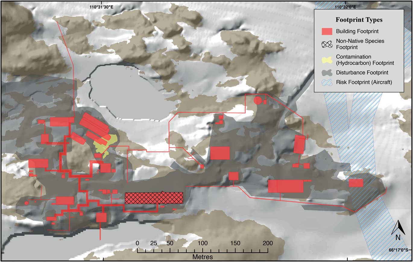
Fig. 1 Example application of five subcategories of footprint mapped around Australia’s Casey Station, Antarctica (note these footprint layers are for illustrative purposes only and may not reflect the actual footprint at this station). Horizontal Datum: WGS84. Projection: UTM Zone 49S. Building, digital elevation model, aircraft approaches, and exposed rock data: Australian Antarctic Division. Hydrocarbon contamination area: McWatters et al. (Reference McWatters, Wilkins, Spedding, Hince, Raymond, Lagerewskij, Terry, Wise and Snape2016) (note this relates to a single spill). Disturbance and non-native species layers are original. Produced by S. Brooks.
The value of establishing a footprint baseline of an operator’s facilities, and communicating that understanding, can go beyond science and policy, to also inform station planners, engineers, environmental managers, regulators and authorities. Although most Antarctic programmes will undoubtedly have a wealth of knowledge about their stations and the environment they inhabit, it is ambitious to expect that an understanding of the full extent of environmental impacts is shared evenly across all operational roles. By quantifying and making available the footprint of Antarctic facilities, operators in different roles could have the means for awareness as well as a ready reference for enquiry.
Footprint and Environmental Impact Assessment
Footprint can also contribute to the implementation and understanding of the term ‘minor or transitory impact’ in the Madrid Protocol (Article 8.1). The vagueness of this crucial component of the Protocol helped give it flexibility to pass the complexities of international negotiations, but left interpretation open to each signatory state (Rothwell Reference Rothwell2000, Fallon & Kriwoken Reference Fallon and Kriwoken2005). When considered in the context of footprint, the term ‘minor’ becomes a measure of scale, and ‘transitory’ a temporal measure of impact.
When considering the term ‘minor’ impact, scale is meaningful only in the context of its location. Whereas one station on a continent of 14 million square kilometres (Hughes Reference Hughes2010) may be insignificant, one in the 0.37% or less of Antarctica that is ice-free (Burton-Johnson et al. Reference Burton-Johnson, Black, Fretwell and Kaluza-Gilbert2016) is more significant. Of even greater significance, the majority of the stations and associated impacts occur in the just c. 0.05% of ice-free Antarctica that is within 2 km of the coast (Hull & Bergstrom Reference Hull and Bergstrom2006). Recognizing that ice-free areas are biogeographically distinct rather than homogeneous (Terauds et al. Reference Terauds, Chown, Morgan, Peat, Watts, Keys, Convey and Bergstrom2012), the scale of a station (considering they can be greater than 250 hectares, see Klein et al. Reference Klein, Kennicutt, Wolff, Sweet, Bloxom, Gielstra and Cleckley2008) can be of significant impact in the context of that environment. Many Antarctic facilities are placed in the relatively small ice-free coastal oases or nunatak ‘habitat islands’ (sensu Hull & Bergstrom Reference Hull and Bergstrom2006) so that the scaling context makes these seemingly minor impacts increase in importance.
For temporal measures of footprint the question arises ‘how long is transitory?’ One CEP Information Paper (New Zealand 2010) proposed that footprint be categorized as greater than, or less than, one year, based upon the associated activities being persistent or transient (acknowledging cumulative transient activities can create persistent impacts). With the exception of truly transitory events (such as tracks in snow), the impacts from non-ongoing activities should possibly be considered permanent until there is sufficient evidence to show that the receiving environment has been or will be restored to a natural state, either through natural processes or human intervention, within a finite period. For example, at Law Base in the Larsemann Hills, Goldsworthy et al. (Reference Goldsworthy, Canning and Riddle2003) found ground that was visibly stained from greywater dumped 10 years previously. Within the Wright Valley and at Marble Point, O’Neill et al. (Reference O’Neill, Balks and López-Martínez2013) found visible impacts from machinery from 50 years earlier. Furthermore, Kennicutt II et al. (Reference Kennicutt II, Klein, Montagna, Sweet, Wade, Palmer, Sericano and Denoux2010) suggested disturbed surfaces at McMurdo could take tens to hundreds of years to recover. Even low intensity activities such as walking on Antarctic soils have been found to result in long-term disturbance (Campbell et al. Reference Campbell, Claridge and Balks1998, Ayres et al. Reference Ayres, Nkem, Wall, Adams, Barrett, Broos, Parsons, Powers, Simmons and Virginia2008). Although many Antarctic environments may have quicker rehabilitation rates than these examples, further research across substrates and climates may be needed to prove this.
Does footprint need to be visible?
The majority of footprint literature is based on measuring visible impacts. Important spatial impacts can, however, be measurable but not visible, such as hydrocarbon contamination (e.g. mapping of elevated hydrocarbons at McMurdo Station, Klein et al. Reference Klein, Sweet, Wade, Sericano and Kennicutt2012). Alternatively, visible impacts may have negligible effects on biota and habitat (and therefore scientific value) yet they may degrade wilderness and aesthetic values (which are also protected under the Madrid Protocol (Article 3)). New Zealand (2010) suggested defining footprint as visible impacts, as they were easily observable and can be an indicator of further non-visible impacts such as compaction, reduced soil biota, and contamination. This is also reflected in the scientific literature, with most terrestrial studies based on visible impacts. This is supported by examples such as the Progress I station in the Larsemann Hills, where hydrocarbon contamination was detected only at sites of visible impacts (Goldsworthy et al. Reference Goldsworthy, Canning and Riddle2003). Conversely, it is expected that the apparent nature of visible impacts is responsible for attracting attention to them. More work is needed here, especially in different Antarctic substrates, to establish the relationship between visible disturbance and actual impacts on biota and natural processes.
Absence of footprint
Locating the full extent of footprint in Antarctica has been suggested as a method to determine inviolate and wilderness areas. New Zealand (2011) proposed that a definition of Antarctic wilderness might be ‘the absence of footprint’. ASOC (2014) also noted that wilderness generally has an ‘inverse relationship to footprint’, but sought to avoid defining wilderness by what it is not. In relation to its scientific value, Hughes et al. (Reference Hughes, Fretwell, Rae, Holmes and Fleming2011) proposed that the absence of visitation could be used to identify areas in need of protection to preserve inviolate areas for the future. This presence or absence of footprint was also used by Belgium et al. (2013) to highlight the importance of long-term conservation of Antarctic microbial habitats and the pressure from an ever increasing visitation footprint, especially in ice-free areas.
Defining footprint
Since the initial mention of footprint in Antarctica there have been repeated calls for developing a conceptual and spatial understanding of Antarctic footprint (Walton & Shears Reference Walton and Shears1994, United States 2003, Summerson & Tin Reference Summerson and Tin2009, Hughes Reference Hughes2010). However, just as there will be differing values placed on the environment across (and within) cultures, the Consultative Parties to the Antarctic Treaty will all have different environmental ethics, and will place varied focus on specific values. These may include differing attitudes to the desirability of impacting wilderness, view shed (the area of visibility of infrastructure and activity), noise, contamination, energy consumption, and conspicuous or discrete facilities. These differing values between cultures may also account for the diversity of definitions of footprint. Despite the definitions provided by ASOC (2014), Jabour (Reference Jabour2009) and New Zealand (2011), all corresponding as a measure of the spatial extent of disturbance, what disturbance is has taken on many meanings. As footprint has gained traction as a term to describe environmental impacts and pressures in Antarctica, clarification to avoid misunderstandings and facilitate discussions should help in improving environmental protection.
Types of footprint
Here are provided three categories of footprint: physical, non-physical, and indirect together with a number of defined subcategories (Table I). Physical footprints are those that can be empirically observed or measured, either visually or through sampling. These may not have easily detectable edges, with gradients dissipating until a background level is reached. Non-physical footprints are those that may not have any biological, mechanical, or chemical disturbance to the natural environment but diminish other values, including wilderness or aesthetics. Risk footprint is included with the non-physical footprints, as it only has the potential to create physical impacts. Indirect footprints are those that have global impacts but may have no detectable effects on the local environment.
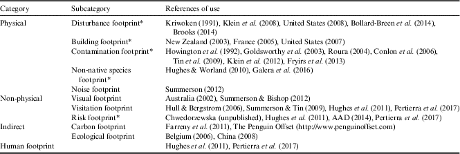
Physical footprints
This category has been the predominant use of footprint in the literature. The original mentions of footprint by Walton and Shears (Reference Walton and Shears1994) and United States (1998) both referred to a spatial measurement of a range of physical impacts. Although a single physical ‘footprint’ dataset would be ideal, it would need to be produced in layers. Combining all facets of physical impacts into one footprint is problematic, as the area polluted by heavy metals measurable in snow around a station, for example, would probably be an order of magnitude greater than that of visible substrate disturbance.
Disturbance footprint
Disturbance footprint is the measure of visible substrate disturbance caused by compaction, clearing, earthworks and other landscape modification from human activities (Fig. 1) and is the dominant use of footprint in the literature and Antarctic Treaty documents. Within CEP documents at least 40% (34) of mentions of footprint were interpreted by the authors as referring to a disturbance footprint. Spatially quantifying the substrate disturbance caused by Antarctic activities predates the first mentions of footprint, such as Kriwoken (Reference Kriwoken1991) highlighting the spatial area impacted by the former and current Casey Stations. Many authors, including Klein et al. (Reference Klein, Kennicutt, Wolff, Sweet, Bloxom, Gielstra and Cleckley2008), Bollard-Breen et al. (Reference Bollard-Breen, Brooks, Jones, Robertson, Betschart, Kung, Craig Cary, Lee and Pointing2014), Brooks (Reference Brooks2014) and Tejedo et al. (Reference Tejedo, Benayas, Cajiao, Albertos, Lara, Pertierra, Andres-Abellan, Wic, Lucianez, Enriquez, Justel and Reck2016), have used footprint to describe areas of physical surface and landscape modification, aligning with this definition. Although visible substrate disturbance may not conclusively affect biota or indicate contamination, it has a direct impact on wilderness and aesthetic values. Work has been done on classifying the degree of substrate disturbance, and how readily it occurs and recovers in some environments (e.g. Campbell et al. Reference Campbell, Claridge and Balks1998, O’Neill et al. Reference O’Neill, Balks and López-Martínez2013), but most approaches have not tackled measuring the gradients of impact that inevitably occur on the outer margins of disturbed areas.
Building footprint
Building footprint is the spatial area covered by a facility’s buildings. This is common terminology in the construction and planning industry globally and is used for the same purpose in Antarctica. Footprint has been used by authors and Treaty Parties to describe the discrete total area covered by a building’s perimeter (e.g. United States 2007, Davis Reference Davis2017). This would be expected to create an underlying disturbance footprint through the need for foundations, disturbance during construction (Brooks Reference Brooks2014), and the effects of light obstruction, wind channelling and snow drifts. Use of this term is usually apparent, but it may need to be referred to as building footprint in documents in which the context is not construction/building specific.
Contamination footprint
Contamination footprint is the area contaminated by a pollutant. This footprint may include a variable depth and concentration aspect. Footprint has been used to describe contamination of the terrestrial, nearshore, and atmospheric local Antarctic environment by organic and inorganic materials, including hydrocarbons, sewage, waste, and other pollution. It could also be used in the context of genetic pollution, where sewage outfalls and microbial contamination from human activities may impact through, for example, lateral gene transfer to native microbes (Cowan et al. Reference Cowan, Chown, Convey, Tuffin, Hughes, Pointing and Vincent2011). This form of footprint has been used in the literature more than in CEP documents, and usually refers to a specific contaminant. Many authors (e.g. Goldsworthy et al. Reference Goldsworthy, Canning and Riddle2003, Roura Reference Roura2004, Tin et al. Reference Tin, Fleming, Hughes, Ainley, Convey, Moreno, Pfeiffer, Scott and Snape2009, Klein et al. Reference Klein, Sweet, Wade, Sericano and Kennicutt2012) have described the area affected by contamination as footprint. Other studies quantify the spatial area and intensity of contamination in Antarctica without referring to it as footprint (e.g. Howington et al. Reference Howington, McFeters, Barry and Smith1992, Fryirs et al. Reference Fryirs, Snape and Babicka2013). Contamination footprint is likely to be associated with (or within) other forms of footprint. When referring to a specific contaminant, the footprint would be best described using the contaminant in question as a prefix (e.g. hydrocarbon contamination footprint).
Non-native species footprint
Non-native species footprint is the localized area of distribution of a non-native species in Antarctica. Although footprint has not yet been used in this context in Antarctica, it may be a useful concept. The spread and density of flora and fauna populations are conventionally termed their ‘distribution’. This is usually tied to species with wide geographical spread, for which it is impractical to provide a figure. However, the distribution of introduced species is more often than not localized, and point sources may be linked directly to the impacts of stations and human activity. Many studies of non-native invertebrate and flora species at sites of human activity in Antarctica have provided the conventional square metre figure (e.g. Pertierra et al. Reference Pertierra, Lara, Benayas and Hughes2013). These figures are useful, but without mapping they do not communicate the spread, intensity or distribution within the natural or built environment. Some studies have mapped non-native species (Hughes & Worland Reference Hughes and Worland2010, Galera et al. Reference Galera, Wódkiewicz, Czyż, Łapiński, Kowalska, Pasik, Rajner, Bylina and Chwedorzewska2016) and these illustrate the distribution, density, and relation of introduced invertebrates and grasses within a station environment, without using the term footprint. Combining the mapping in these examples with considering the distribution of non-native species in the context of being a direct result of human activities demonstrates how a non-native species footprint could provide a useful additional layer to assessing the environment and impacts of an Antarctic station or site.
Noise footprint
Noise footprint is an established term describing the spatial area in which noise from a source, usually above a set decibel reading, can be measured. This is most commonly used by the aeronautical industry. Noise footprint has application in Antarctica as it has a direct impact on wilderness values (Summerson Reference Summerson2012), and there is concern about the effects of noise on wildlife, with some evidence of affected behaviour (Tin et al. Reference Tin, Fleming, Hughes, Ainley, Convey, Moreno, Pfeiffer, Scott and Snape2009). Although scientific and CEP documents have given attention to the terrestrial emission of noise from Antarctic activities, literature relating to the spatial area impacted is less common.
Non-physical footprints
Visual footprint
Visual footprint is the area of visibility of infrastructure and activity, also known as ‘view shed’. Within the Madrid Protocol, the environmental principles include protection of wilderness and aesthetic significance (Article 3), and it is these values that are inherently degraded by visual footprint. Summerson and Bishop (Reference Summerson and Bishop2012) found the visual footprint of Antarctic stations and their infrastructure to have the greatest effect on such values. Most evidence indicates visual footprint affects wildlife in combination with noise and human presence, but there is limited knowledge of its effects in isolation. Visibility footprint was previously included in Australian Antarctic State of the Environment reporting (Australia 2002).
Visitation footprint
Visitation footprint refers to the land area of Antarctica that has had human presence. Although the term visitation footprint was neither explicitly found in Antarctic literature nor expressly referred to in the Madrid Protocol, 19% (16) of mentions of footprint within CEP documents, the second highest occurrence after disturbance, were interpreted by the authors as referring to it. Tourism sites are included in this footprint, although cumulative impacts may lead to additional types of footprints (Roura Reference Roura2011). Summerson & Tin (Reference Summerson and Tin2009) referred to this as the ‘activity’ component of a human footprint. Hull & Bergstrom (Reference Hull and Bergstrom2006) and Hughes et al. (Reference Hughes, Fretwell, Rae, Holmes and Fleming2011) used footprint maps extrapolated from expedition data to indicate the visitation presence of national programmes. Pertierra et al. (Reference Pertierra, Hughes, Vega and Olalla-Tarraga2017) also used this approach, applying global footprint methodology from Sanderson et al. (Reference Sanderson, Jaiteh, Levy, Redford, Wannebo and Woolmer2002) to infer the probable area of human visitation from Antarctic facilities. Although the environmental impacts from the majority of visited areas in Antarctica are probably below currently measurable levels, and are ‘transient’ (Summerson & Tin Reference Summerson and Tin2009), concern has been raised regarding the risk footprint it creates for microbial contamination (Belgium et al. 2013, Hughes et al. Reference Hughes, Cowan and Wilmotte2015), non-native species, and reduction in area of reference-state natural environments (Hughes et al. Reference Hughes, Fretwell, Rae, Holmes and Fleming2011). Despite the value to science and management in knowing where people have been in Antarctica, as well as most contemporary expeditions maintaining global positioning system (GPS) data and transect logs, these data are seldom compiled or published.
Risk footprint
Risk footprint is the area exposed to either potential physical impacts in the event of an incident, or impacts not yet detected. Identifying and understanding threats posed to vulnerable areas through risk footprints is suggested as an avenue to reduce environmental impacts through all stages of an activity. An example of an application of this could be the 2010 emergency jettison of three fuel drums, carried by helicopter, into the catchment of Lake Dingle in the Vestfold Hills (an area frequented by wildlife and of scientific interest, see also Raymond et al. Reference Raymond, King, Raymond, Stark and Snape2016). As jettisoning sling-loaded cargo from a helicopter in the event of loss of flight stability is a foreseeable occurrence, the use of a risk footprint in flight path mapping may suggest flying over less vulnerable areas. Risk footprint may also include areas exposed to impacts that are not yet fully understood or detected (including examples given within Visitation footprint). Although this term is yet to gain traction within Antarctic literature, referring to the risk of environmental impacts from the footprint of activities, especially of vectors of species introduction, is already in use (e.g. Hughes et al. Reference Hughes, Fretwell, Rae, Holmes and Fleming2011, Pertierra et al. Reference Pertierra, Hughes, Vega and Olalla-Tarraga2017 and Chwedorzewska unpublished, 2010). It is believed that risk footprint is already used inherently in planning and logistics for siting infrastructure such as bulk fuel storage and potential areas of contamination in the event of a major spill.
Indirect footprints
Carbon footprint
As in other parts of the world, carbon footprint in Antarctica is a departure from a spatial measurement, and implies the greenhouse gas emission contribution from an activity or facility. The use of the term carbon footprint is usually apparent, and is most often in reference to Antarctic tourism (e.g. Farreny et al. Reference Farreny, Oliver-Solà, Lamers, Amelung, Gabarrell, Rieradevall, Boada and Benayas2011). Despite being raised within policy discussions (CEP 2010), it receives limited attention in the published literature. Although there is little room for confusion regarding the term, its predominant use outside Antarctic literature leads to other applications of footprint being mistaken for it.
Ecological footprint
Ecological footprint, using a definition similar to that of Rees (Reference Rees1992), refers to the resource consumption requirements of an Antarctic station. This has also been referred to as environmental footprint. Although an ecological footprint analysis could be applied to any Antarctic station, its result would be unusual given the unique nature of stations. Because of the need to import nearly all resources, the energy requirements in the extreme conditions, and the small populations, the ecological footprint of an Antarctic research station would probably appear disproportionate to elsewhere in the world. Although reducing a station’s resource consumption would have flow-on effects for other forms of footprint, such as less area for fuel storage, this particular measurement, as suggested by Jabour (Reference Jabour2009), is of limited use. Ecological footprint has been used to refer to the energy efficiency of Antarctic stations, especially new constructions (e.g. Belgium 2006, China 2008).
Human footprint
Human footprint is a combination of all categories of footprints, measuring impacts ranging from areas of influence through to, and including, heavily modified landscapes. It is also used throughout the literature as a figurative term to describe the cumulative area of activity across the continent, encompassing most forms of footprint, without reference to a measurement. Human footprint appears to be derived from the usage by Sanderson et al. (Reference Sanderson, Jaiteh, Levy, Redford, Wannebo and Woolmer2002), presenting a global-scale approach combining disturbance, accessibility, and visitation footprints. What exactly is measured by human footprint varies in the literature. Generally it has been used to measure continent- or region-wide trends and to reveal the scale of area visited by Antarctic programmes. Summerson & Tin (Reference Summerson and Tin2009, p. 178) provided a clear summary of their interpretation, with ‘infrastructure (buildings and structures) and activity (people doing things or in transit)’ being the major components. A similar interpretation (visitation and sites) has been used to map the human footprint of the British Antarctic Survey (Hughes et al. Reference Hughes, Fretwell, Rae, Holmes and Fleming2011), whereas Pertierra et al. (Reference Pertierra, Hughes, Vega and Olalla-Tarraga2017) took a continental approach to human footprint, applying a footprint score at set radiuses of up to 5 km from point locations of Antarctic stations. In other documents, human footprint has also been used to describe disturbance (e.g. Tejedo et al. Reference Tejedo, Benayas, Cajiao, Albertos, Lara, Pertierra, Andres-Abellan, Wic, Lucianez, Enriquez, Justel and Reck2016). The problem with combining disturbance and visitation footprints together as a measurement is that they are useful only if presented as layers or gradients that distinguish the levels of impact. Mapping together rare visitation to an area, with no measurable lasting impacts or with set buffer radiuses from facilities, with permanent landscape disturbance from a station is of limited practical management use.
Discussion
Footprint has become a regularly used description of the impact of activities in Antarctica for quantification and communication. The lack of clarity around the meaning of the term, demonstrated by ongoing policy discussion attempting to define footprint, makes it evident that rationalizing and consolidating terminology is required. The primary usage of footprint to date has been as a measure of the spatial extent of disturbance, but that too requires clarification. The initial application of footprint (Walton & Shears Reference Walton and Shears1994) referred to an example of snow contaminated with heavy metal emissions from a station, whereas the largest project to measure footprint (Klein et al. Reference Klein, Kennicutt, Wolff, Sweet, Bloxom, Gielstra and Cleckley2008) referred to visible terrestrial substrate disturbance. The footprints of transitory activities are also not equal, e.g. subject to the receiving environment, the disturbance footprint of a small ice-free field campsite (e.g. Bollard-Breen et al. Reference Bollard-Breen, Brooks, Jones, Robertson, Betschart, Kung, Craig Cary, Lee and Pointing2014) may be evident much longer than that of a major ice tractor train expedition. More work is needed to establish restoration rates for the different Antarctic environments, as well as to determine techniques to minimize these rates initially, such as whether reusing sacrificial disturbance footprint areas is preferable to disseminating impacts over a wider area.
The reason for the varied interpretation of footprint may be attributed to the variety of motivations or purposes for the work. Combined human footprint measurements provide a useful indication of an Antarctic programme’s regional sphere of influence, of inviolate areas, and of areas exposed to the potential for introduction of species, but are of little use if they do not convey varying intensity of impacts. However, there are many specific forms of footprint that are based on empirical data from measurable impacts. These have been mapped for the facilities of several Antarctic programmes, but scarcely for tourism. Although some forms of footprint are not as evident for the majority of Antarctic tourism as they are for national programmes (e.g. buildings), or are more transient, evidence of cumulative disturbance footprints such as that found by Tejedo et al. (Reference Tejedo, Benayas, Cajiao, Albertos, Lara, Pertierra, Andres-Abellan, Wic, Lucianez, Enriquez, Justel and Reck2016), and external calls for assessment (ASOC 2012), suggest that impacts from tourism should be included in footprint assessments.
Conclusion
Unlike any other continent, Antarctica presents the unique opportunity to quantify human activity and disturbance by where it occurs, as opposed to where it does not. Effectively the inverse of wilderness area, footprint has become the term used to quantify those areas of Antarctica affected by human activity. Using clear terminology for the various types of footprints should eventually lead to the development of consistent footprint datasets that will support management activity and decision making. We propose that footprint prefixes are used hereafter to ensure clarity by describing the context under consideration. The use of the general term human footprint to describe a specific type of impact should be avoided, but may be used as a unifying concept for many types of footprints. Moving towards more consistent applications of the term footprint in Antarctica will help progress the use of footprint measurements and improve awareness and communication of impacts to Antarctic programmes, policymakers, scientists, and on-the-ground operators. Furthermore, a useful working definition and understanding of footprint may help in moving towards a common approach to the terms ‘minor’ and ‘transitory’, which are significant to the Madrid Protocol’s regulation of environmental impacts.
Acknowledgements
Tom Maggs provided support in original concept development. We dedicate this paper to his memory. S.T. Brooks is supported by an Australian Government Research Training Program Scholarship. Tim Spedding and Dan Wilkins provided assistance with hydrocarbon spill information for Casey Station. We also thank Phil Tracey, David Walton, Ricardo Roura, and two anonymous reviewers for their thought-provoking feedback and valuable suggestions.
Author contributions
S.T. Brooks led the conceptual development and writing of the paper. Drs J. Jabour and D.M. Bergstrom contributed to conceptual and content development, expert advice, and drafting and revisions of the manuscript.


