

1. Introduction
The Zagros orogen stands at the tectonic crossroads of the Alpine–Himalayan belts. Its formation results from the long-standing convergence between Eurasia and Gondwanian-derived fragments, as underlined by ophiolite belts or present-day GPS vectors (Fig. 1a). The Zagros orogen hosts considerable oil resources and spectacular, world famous whaleback folds. Yet, despite a wealth of recent data on GPS displacements, active deformation and kinematics (e.g. Vernant et al. Reference Vernant, Nilforoushan, Hatzfeld, Abbassi, Vigny, Masson, Nankali, Martinod, Ashtiani, Bayer, Tavakoli and Chery2004; Walker, Reference Walker2006; Le Dortz et al. Reference Le Dortz, Meyer, Sébrier, Nazari, Braucher, Fattahi, Benedetti, Foroutan, Siame, Bourlès, Talebian, Bateman and Ghoraishi2009; Allen et al. Reference Allen, Kheirkhah, Emami and Jones2011; Reilinger & McClusky, Reference Reilinger and McClusky2010) or on the tectonosedimentary record (e.g. Sherkati, Letouzey & Frizon de Lamotte, Reference Sherkati, Letouzey and Frizon De Lamotte2006; Mouthereau et al. Reference Mouthereau, Tensi, Bellahsen, Lacombe, Boisgrollier and Kargar2007; Homke et al. Reference Homke, Vergés, Serra-Kiel, Bernaola, Sharp, Garcés, Montero-Verdù, Karpuz and Goodarzi2009, Reference Homke, Verges, Van Der Beek, Fernandez, Saura, Barbero, Badics and Labrin2010), the Zagros orogen remains much less documented than its adjacent counterparts (the Himalayas, Turkey or the Alps).
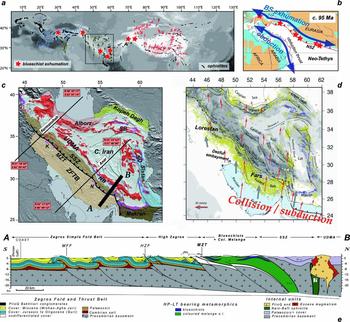
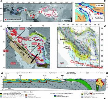
Figure 1. (a) The Zagros orogen: a central segment (at the tectonic crossroads) of the gigantic Alpine convergence zone from the Himalayas to the Western Mediterranean region. Present-day convergence underlined by GPS vectors (after Vernant et al. Reference Vernant, Nilforoushan, Hatzfeld, Abbassi, Vigny, Masson, Nankali, Martinod, Ashtiani, Bayer, Tavakoli and Chery2004). Finite convergence is underlined by ophiolites (in black; after Khan et al. Reference Khan, Flower, Sultan and Sandvol2006) sandwiched between the major tectonic domains and high-pressure, low-temperature rocks (red stars; mostly blueschists) returned from the Neo-Tethyan suture zone. Topography as background greyscale. Frame shows location of (b) and (c). (b) Simplified palaeogeographic reconstruction for the Neo-Tethys during Late Cretaceous time (c. 95 Ma; after Vrielynck & Bouysse, Reference Vrielynck and Bouysse2003; Barrier & Vrielynck, Reference Barrier and Vrielynck2008). The location (and regional extent) of blueschist exhumation in the NSZ (Neo-Tethyan subduction zone) is compared with that of obduction to the south of the Neo-Tethys. (c) Simplified geological map of Iran showing the main tectonic subdivisions and locations discussed in the text. Also shown are the two transects (Kermanshah, Anar) whose lithospheric-scale reconstructions are shown in Figure 10 (corresponding tomographic sections are shown in Fig. 9). Abbreviations: K – Kermanshah; MZT – Main Zagros Thrust; N – Neyriz; NB – Nain–Baft; SB – Sabzevar; SO – Sistan ocean; SSZ – Sanandaj–Sirjan Zone; UDMA – Urumieh–Dokhtar Magmatic Arc; ZFTB – Zagros fold-and-thrust belt. (d) Present-day deformation of Iran, as seen through seismicity (yellow dots) and the location of major active faults (for deformation partitioning, see also Fig. 13a). GPS vectors shown in red. Note the transition from active oceanic subduction to collision across the Hormuz strait. (e) Section across the Zagros orogen (location shown in (c)), showing the spectacular deformation of the ZFTB, the presence of high-pressure, low-temperature rocks in the suture zone, and the main domains found in the upper Eurasian plate (i.e. SSZ, Nain–Baft, UDMA, Central Iran; after Agard et al. Reference Agard, Monie, Gerber, Omrani, Molinaro, Meyer, Labrousse, Vrielynck, Jolivet and Yamato2006). Abbreviations: HZF – High Zagros Fault; MFF – Main Front Fault; MZT – Main Zagros Thrust; SSZ – Sanandaj–Sirjan Zone; Tr–J – Triassic to Jurassic cover of SSZ and Central Iran; UDMA – Urumieh–Dokhtar Magmatic Arc. See text (in particular Section 3) for details.
As for other segments of the Alpine–Himalayan belts, the Zagros collision zone formed as a result of the disappearance of the Neo-Tethys Ocean (e.g. Takin Reference Takin1972; Ricou, Braud & Brunn, Reference Ricou, Braud and Brunn1977; Alavi Reference Alavi1980, Reference Alavi1994; Berberian & King, Reference Berberian and King1981; Dercourt et al. Reference Dercourt, Zonenshain, Ricou, Kazmin, Le Pichon, Knipper, Grandjacquet, Sbortshikov, Geyssant, Lepvrier, Pechersky, Boulin, Sibuet, Savostin, Sorokhtin, Westphal, Bazhenov, Lauer and Biju-Duval1986; Dercourt, Ricou & Vrielynck, Reference Dercourt, Ricou and Vrielynck1993; Sengör et al. Reference Sengör, Altiner, Cin, Ustaömer, Hsü, Audley-Charles and Hallam1988; Stampfli & Borel, Reference Stampfli and Borel2002; Agard et al. Reference Agard, Omrani, Jolivet and Mouthereau2005; Hafkenscheid, Wortel & Spakman, Reference Hafkenscheid, Wortel and Spakman2006) between Arabia and Eurasia (Fig. 1b). The timing of collision, however, has been highly controversial, ranging from Late Cretaceous (Berberian & King, Reference Berberian and King1981) to Miocene (Berberian & Berberian, Reference Berberian, Berberian, Gupta and Delany1981) or uppermost Pliocene (Stöcklin, Reference Stöcklin1968), to only mention cornerstone papers. Although there is a growing body of evidence in support of Late Eocene to Oligocene initial collision (e.g. Jolivet & Faccenna, Reference Jolivet and Faccenna2000; Agard et al. Reference Agard, Omrani, Jolivet and Mouthereau2005; Vincent et al. Reference Vincent, Allen, Ismail-Zadeh, Flecker, Foland and Simmons2005; Ballato et al. Reference Ballato, Mulch, Landgraf, Strecker, Dalconi, Friedrich and Tabatabaei2010 and references therein), very contrasting interpretations are still published (e.g. Ghalamghash et al. Reference Ghalamghash, Bouchez, Vosoughi-Abedini and Nédélec2009; Mazhari et al. Reference Mazhari, Bea, Amini, Ghalamghash, Molina, Montero, Scarrow and Williams2009b). The position of the suture zone itself, regarded by most authors to lie along the Main Zagros Thrust (MZT; Fig. 1c; Stöcklin, Reference Stöcklin1968; Ricou, Braud & Brunn, Reference Ricou, Braud and Brunn1977; Agard et al. Reference Agard, Omrani, Jolivet and Mouthereau2005, Reference Agard, Monie, Gerber, Omrani, Molinaro, Meyer, Labrousse, Vrielynck, Jolivet and Yamato2006; Paul et al. Reference Paul, Kaviani, Hatzfeld, Vergne and Mokhtari2006, Reference Paul, Hatzfeld, Kaviani, Tatar, Pequegnat, Leturmy and Robin2010), is also still discussed (Alavi, Reference Alavi1994; Shafaii Moghadam, Stern & Rahgoshay, Reference Shafaii Moghadam, Stern and Rahgoshay2010). Finally, compared to our understanding of active tectonics and foreland deformation, much less is known about the hinterland, subduction-related arcs trending parallel to the Zagros, namely the Sanandaj–Sirjan Zone (SSZ) and the Urumieh–Dokhtar Magmatic Arc (UDMA; Fig. 1c).
A number of questions therefore remain unanswered or unsettled: when did initial collision and shortening happen, and was it diachronous along strike? How was deformation partitioned in space and time? Did one or several slab break-offs occur (i.e. fragmentation and sinking of a piece of subducting oceanic slab; von Blanckenburg & Davies, Reference Von Blanckenburg and Huw Davies1995)? How can the changing patterns of arc magmatism be explained? And, more fundamentally, can the Zagros be considered a model of immature collision, such as a young Himalayas or Turkey (Fig. 1a; i.e. with a smaller plateau and perhaps a younger collision; Hatzfeld & Molnar, Reference Hatzfeld and Molnar2010)? What are the detailed links between the Zagros build-up and the overall Neo-Tethyan history (Fig. 1b) or with the rest of Iran (Fig. 1c)? What are the respective contributions of subduction and collision stages to the formation of this orogenic belt?
The aims of the present paper are thus to provide (1) a review of our present knowledge of the Zagros orogen and (2) lithospheric-scale reconstructions in 2D along two parallel, SW–NE transects across the Zagros, with emphasis on the constraints derived from the internal zones. We first present a synthetic overview of the geological data available on the Zagros orogen, and then outline the major events that any lithospheric reconstruction of the Zagros orogen should account for. We then present our reconstructions, discuss them and outline specific points of focus (history and geodynamics, upper plate deformation, comparison with Neo-Tethyan orogens). We will attempt to demonstrate that the Zagros orogeny is in fact largely governed by subduction processes.
2. Overview of the Arabia–Eurasia convergence across the Zagros
2.a. Regional extent and tectonic subdivisions
The Zagros orogen extends from the Turkish–Iranian border to the NW, to the Makran area in the SE (where oceanic subduction is still active; Ellouz-Zimmermann et al. Reference Ellouz-Zimmermann, Lallemant, Castilla, Mouchot, Leturmy, Battani, Buret, Cherel, Desaubliaux, Deville, Ferrand, Lügke, Mahieux, Mascle, Mühr, Pierson-Wickmann, Robion, Schmitz, Danish, Hasany, Shahzad, Tabreez, Lacombe, Lavé, Vergès and Roure2007; Smit et al. Reference Smit, Burg, Dolati and Sokoutis2010b; Fig. 1c, d). In an orographic sense, the Zagros orogen comprises the following sub-parallel tectonostratigraphic domains, from SW to NE: the Zagros foreland basin, the Simply Folded Belt, the more mountainous part of the Zagros proper (including the High Zagros and the Crush Zone) as well as domains that can be thought of belonging to the Zagros orogen in a broader sense: the SSZ (or Central Iranian active margin; Berberian & King, Reference Berberian and King1981), the UDMA and the western parts of Central Iran (Fig. 1e).
The interested reader is referred to Stöcklin (Reference Stöcklin1968) for historical tectonic subdivisions of the Zagros orogen. The Zagros was initially considered to lie to the SW of the MZT by Stöcklin (Reference Stöcklin1968), whereas he referred to the part to the NE of the MZT as Central Iran. This latter part was later termed the internal Zagros (Reyre & Mohafez, Reference Reyre and Mohafez1970; J. Braud, unpub. Ph.D. thesis, Univ. Paris-Sud, 1987), emphasizing, as already recognized by Stöcklin, the importance of Tertiary deformation over the whole of Iran. In fact, several other adjacent domains located in the far-field of Zagros deformation should be considered whenever studying the Zagros orogeny (e.g. Jackson, Hains & Holt, Reference Jackson, Hains and Holt1995): these are the Alborz, Kopet Dagh, Central Iran and Sistan regions (Fig. 1 c, d). We will indeed show that the history of the Zagros orogeny largely overlaps with the deformation history of most of Iran since the Jurassic. All these domains are further described in what follows (Section 3).
It is convenient, however, to outline from the start a more fundamental division, between a lower and an upper lithospheric plate. Calc-alkaline, arc-related magmatism found in the SSZ and UDMA (Fig. 2) provide compelling evidence for past convergence and northward subduction of the Neo-Tethys Ocean (now vanished everywhere but in front of the accretionary prism of Makran) below Eurasia (Fig. 1b; Berberian & Berberian, Reference Berberian, Berberian, Gupta and Delany1981).

Figure 2. Compilation of magmatism in Iran through time (upper Eurasian plate) through 250000 scale maps from the Geological Survey of Iran.
This boundary between the upper (Eurasia) and lower (Arabia) plates runs along the MZT (Fig. 2), as supported by the presence of ophiolite fragments (Ricou Reference Ricou1971; Ricou, Braud & Brunn, Reference Ricou, Braud and Brunn1977), high-pressure, low-temperature, mainly blueschist facies rocks (Sabzehei et al. Reference Sabzehei, Berberian, Roshanravan, Azizan, Nazemzadeh, Alavi-Tehrani, Houchmand-Zadeh, Nowgole-Sadat and Madjidi1994; Agard et al. Reference Agard, Monie, Gerber, Omrani, Molinaro, Meyer, Labrousse, Vrielynck, Jolivet and Yamato2006), the style of deformation (Agard et al. Reference Agard, Omrani, Jolivet and Mouthereau2005) and seismic profiles tracing this thrust down to Moho depths (Paul et al. Reference Paul, Kaviani, Hatzfeld, Vergne and Mokhtari2006, Reference Paul, Hatzfeld, Kaviani, Tatar, Pequegnat, Leturmy and Robin2010). It can be useful to recall that Alavi (Reference Alavi1994) proposed an alternative location for the suture zone between the SSZ and the UDMA, because this option was considered in a number of later publications and only recently refuted (Agard et al. Reference Agard, Omrani, Jolivet and Mouthereau2005; Paul et al. Reference Paul, Kaviani, Hatzfeld, Vergne and Mokhtari2006).
The MZT thus defines the boundary between the Arabian, lower plate external zones to the SW and the Eurasian, upper plate internal zones to the NE (cross-section Fig. 1e, Fig. 2). We give below a brief overview of the various domains, for which synthetic stratigraphic columns of the Zagros (Arabia) and Central Iran (Eurasia) are shown in Figure 3 (and for which a wealth of papers are available; for details, see more in-depth publications, e.g. James & Wynd, Reference James and Wynd1965; Motiei, Reference Motiei1993; Homke et al. Reference Homke, Vergés, Serra-Kiel, Bernaola, Sharp, Garcés, Montero-Verdù, Karpuz and Goodarzi2009). Emphasis will be placed here on the internal zones, which provide crucial constraints for the geodynamic evolution of the Zagros orogen. All domains share a common Infracambrian to Middle Triassic ~ 3 km thick sequence of platform deposits, very constant throughout Iran (Stöcklin, Reference Stöcklin1968), overlying a presumably Arabian-type basement structured during late Precambrian ‘Assyntic’ or Pan-African times (Hassanzadeh et al. Reference Hassanzadeh, Stockli, Horton, Axen, Stockli, Grove, Schmitt and Walker2008). Some N–S trends (Oman line and Qatar high; Gansser, Reference Gansser1960), and possibly even early NW–SE trends (e.g. controlling the deposition of the Cambrian Hormuz salt), are thought to be inherited from these deformation episodes. No significant deformation affected Iran during Palaeozoic times, apart from the Permian–Triassic rifting which gave birth to the Neo-Tethys. Major contrasts on either side of what is now the MZT formed from Late Triassic time onwards.

Figure 3. Simplified stratigraphic columns for the ZFTB (see also Alavi, Reference Alavi2007, fig. 8) and for Central Iran. Modified after Aghanabati & Rezai (Reference Aghanabati and Rezai2009).
Before recalling essential characteristics of the various palaeogeographic domains, we start by giving an outline of the present-day deformation patterns as seen by GPS and tracking of active faults.
2.b. Present-day partitioning of the deformation through the Zagros orogen
Present-day kinematics indicates a northward motion of the Arabian plate relative to Eurasia of 22 ± 2 mm yr−1 (Vernant et al. Reference Vernant, Nilforoushan, Hatzfeld, Abbassi, Vigny, Masson, Nankali, Martinod, Ashtiani, Bayer, Tavakoli and Chery2004). GPS vectors reveal that the overall present-day strain field across the Zagros, in response to the Arabia–Eurasia convergence, is directed N–S to N010 on average (Fig. 1b, d; Masson et al. Reference Masson, Anvari, Djamour, Walpersdorf, Tavakoli, Daignières, Nankali and Van Gorp2007), that is, oblique by ~ 20–30° to the principal long-term SW–NE shortening direction across the orogen (Fig. 1d). Northward convergence is accommodated (Jackson, Hains & Holt, Reference Jackson, Hains and Holt1995; Allen et al. Reference Allen, Blanc, Walker, Jackson, Talebian and Ghassemi2006; Hatzfeld & Molnar, Reference Hatzfeld and Molnar2010) through a combination of:
(1) across-range shortening in the Zagros orogen and in far-field domains (Alborz, Kopet Dagh) at rates of 5 ± 2 mm yr−1 (McClusky et al. Reference McClusky, Balassanian, Barka, Demir, Ergintav, Georgiev, Gurkan, Hamburger, Hurst, Kahle, Kastens, Kekelidze, King, Kotzev, Lenk, Mahmoud, Mishin, Nadariya, Ouzounis, Paradissis, Peter, Prilepin, Reilinger, Sanli, Seeger, Tealeb, Toksoz and Veis2000; Vernant et al. Reference Vernant, Nilforoushan, Hatzfeld, Abbassi, Vigny, Masson, Nankali, Martinod, Ashtiani, Bayer, Tavakoli and Chery2004; Walpersdorf et al. Reference Walpersdorf, Hatzfeld, Nankali, Tavakoli, Nilforoushan, Tatar, Vernant, Chéry and Masson2006; Masson et al. Reference Masson, Anvari, Djamour, Walpersdorf, Tavakoli, Daignières, Nankali and Van Gorp2007). Deformation was concentrated in the Zagros and the Alborz since Pliocene time at least (Oveisi et al. Reference Oveisi, Lavé, Van Der Beek, Carcaillet, Benedetti and Aubourg2009; Allen et al. Reference Allen, Kheirkhah, Emami and Jones2011) at a probably constant rate over the last 5 Ma (Lacombe et al. Reference Lacombe, Mouthereau, Kargar and Meyer2006, Reference Lacombe, Amrouch, Mouthereau and Dissez2007). Out of the ~ 2 cm yr−1 of overall orogen-normal shortening component, two thirds are taken up in the Zagros fold-and-thrust belt (ZFTB) and one third in the Alborz, with domains such as the SSZ behaving more rigidly (Masson et al. Reference Masson, Anvari, Djamour, Walpersdorf, Tavakoli, Daignières, Nankali and Van Gorp2007).
(2) dextral strike-slip movements across the Main Recent Fault (MRF; 3–15 mm yr−1; Talebian & Jackson, Reference Talebian and Jackson2002, Reference Talebian and Jackson2004; Authemayou et al. Reference Authemayou, Bellier, Chardon, Benedetti, Malekzade, Claude, Angeletti, Shabanian and Abbassi2009), the Kazerun fault (Authemayou et al. Reference Authemayou, Chardon, Bellier, Malekzadeh, Shabanian and Abbassi2006, Reference Authemayou, Bellier, Chardon, Benedetti, Malekzade, Claude, Angeletti, Shabanian and Abbassi2009) and subordinate faults east of the Kazerun fault proper (Lacombe et al. Reference Lacombe, Mouthereau, Kargar and Meyer2006). Several N–S-trending faults also cut across the Iranian plateau (e.g. from west to east: the Deshir, Anar, Nayband–Gowk and Ney faults; Walker & Jackson, Reference Walker and Jackson2002; Regard et al. Reference Regard, Bellier, Thomas, Abbassi, Mercier, Shabanian, Feghhi and Soleymani2004; Meyer et al. Reference Meyer, Mouthereau, Lacombe and Agard2006; Meyer & Le Dortz, Reference Meyer and Dortz2007; Le Dortz et al. Reference Le Dortz, Meyer, Sébrier, Nazari, Braucher, Fattahi, Benedetti, Foroutan, Siame, Bourlès, Talebian, Bateman and Ghoraishi2009).
Overall, deformation partitioning across Iran can be viewed as shown in Figure 1d. The predominance of N–S dextral strike-slip faults to the east of the Kazerun–Doruneh faults could correspond to Iran moving north with respect to stable Afghanistan and/or to the existence of a somewhat freer boundary in the still subducting Makran region (at least before Pliocene time; Allen et al. Reference Allen, Kheirkhah, Emami and Jones2011; Regard et al. Reference Regard, Hatzfeld, Molinaro, Aubourg, Bayer, Bellier, Yamini-Fard, Peyret, Abbassi, Leturmy and Robin2010; Smit et al. Reference Smit, Burg, Dolati and Sokoutis2010b). Some of these major faults represent long-lived structures, such as the MRF or the Neh fault, which both reactivate suture zones (Talebian & Jackson, Reference Talebian and Jackson2002; Walker et al. Reference Walker, Gans, Allen, Jackson, Khatib, Marsh and Zarrinkoub2009).
3. Geological setting of the main palaeogeographic domains
3.a. The Zagros fold-and-thrust belt
The Zagros fold-and-thrust belt (ZFTB) classically comprises the geographic provinces of Lurestan and Fars separated by the Dezful Embayment (Fig. 1d). The ZFTB can be divided into two distinct domains from the SW to NE (Fig. 4a), with major changes in structural style and topography: (a) the Simply Folded Belt (SFB) is found in the vicinity of the Persian Gulf and shows fairly regular wavelength folds running along hundreds of kilometres (Falcon, Reference Falcon and Spencer1974; Sepehr & Cosgrove, Reference Sepehr and Cosgrove2004; Mouthereau, Lacombe & Meyer, Reference Mouthereau, Lacombe and Meyer2006). The SFB is in fact also cut by several hidden major faults and progressively steps up in elevation towards the NE (Berberian, Reference Berberian1995; Leturmy, Molinaro & Frizon de Lamotte, Reference Leturmy, Molinaro, Frizon De Lamotte, Leturmy and Robin2010); (b) the High Zagros shows higher elevation, a sharp increase in elevation and kilometre-scale throws on major thrusts.

Figure 4. (a) Map of the Zagros orogen. Compilation of shortening estimates (bold numbers, in kilometres) from recently published cross-sections (A: Alavi, Reference Alavi2007; B: Blanc et al. Reference Blanc, Allen, Inger and Hassani2003; M: Mouthereau et al. Reference Mouthereau, Tensi, Bellahsen, Lacombe, Boisgrollier and Kargar2007; Mo: Molinaro et al. Reference Molinaro, Leturmy, Guezou, Frizon De Lamotte and Eshraghi2005; Q: McQuarrie, Reference McQuarrie2004; S: Sherkati, Letouzey & Frizon de Lamotte, Reference Sherkati, Letouzey and Frizon De Lamotte2006). Empty stars with numbers locate available radiometric datings for the SSZ, which are shown in Figure 5c. Other symbols correspond to reference geochemical data given in Figure 5a, b (as in Omrani et al. Reference Omrani, Agard, Whitechurch, Benoit, Prouteau and Jolivet2008): black and white symbols refer to Eocene and Upper Miocene to Plio-quaternary UDMA samples, respectively, whereas diamonds correspond to SSZ samples. Places where adakites are found in the UDMA are shown with an orange rectangle. Grey dotted ellipses recall the age range obtained from apatite fission-track and U–Th–He data (after Gavillot et al. Reference Gavillot, Axen, Stockli, Horton and Fakhari2010; Homke et al. Reference Homke, Verges, Van Der Beek, Fernandez, Saura, Barbero, Badics and Labrin2010; J. Omrani, unpub. Ph.D. thesis, Institut des Sciences de la Terre, Paris, Reference Omrani, Agard, Whitechurch, Benoit, Prouteau and Jolivet2008). Abbreviations: CC – core-complexes ETMD – Early Tertiary Magmatic Domain; SFB – Simply Folded Belt; SSZ, UDMA, ZFTB – as for Fig. 1c. Ophiolitic bodies in purple. (b) Section across the Crush Zone in the Kermanshah region (A–B shown on (a)) and tectonic evolution since Late Cretaceous time. Adapted from Agard et al. (Reference Agard, Omrani, Jolivet and Mouthereau2005) and Omrani et al. (unpub. data), and Wrobel-Daveau et al. (Reference Wrobel-Daveau, Ringenbach, Tavakoli, Ruiz, Masse and Frizon De Lamotte2010) for the Late Cretaceous stage. Abbreviations: ETMD – Early Tertiary Magmatic Domain; H – Hamadan; K – Kermanshah; MZT, SSZ, ZFTB – as for Fig. 1c, e. Note how little is left from the Neo-Tethyan ophiolite: much (if not all) of the peridotites correspond to the basement of the ETMD and to earlier stretched sub-continental mantle from the Arabian margin. Also note that 70 km is a minimum shortening estimate since internal ductile deformation cannot be constrained precisely. Plutons in the SSZ are already largely exhumed at 20 Ma, as shown by fission-track data (Fig. 4a).
The ZFTB essentially corresponds to the Eo-Cambrian to Quaternary cover of the Arabian plate deformed above the Arabian basement, with a maximum thickness of 12–13 km (James & Wynd, Reference James and Wynd1965; Motiei, Reference Motiei1993; Alavi, Reference Alavi2007) and a deeper Zagros distal basin individualized since Late Triassic time. This sedimentary cover dominantly comprises shelf carbonates, together with several evaporitic low viscosity layers (i.e. Cambrian Hormuz salt and the Early–Middle Miocene Gachsaran Formation; Sherkati et al. Reference Sherkati, Molinaro, Frizon De Lamotte and Letouzey2005; Fig. 3), which acted as major mechanical decollement horizons, thickened fold hinges and favoured spectacular thin-skinned deformation (Blanc et al. Reference Blanc, Allen, Inger and Hassani2003; McQuarrie, Reference McQuarrie2004; Sherkati et al. Reference Sherkati, Molinaro, Frizon De Lamotte and Letouzey2005). Thin-skinned deformation produced regular fold wavelengths (i.e. ~ 15 km), yet only accounts for a subordinate amount of the overall deformation (Agard et al. Reference Agard, Monie, Gerber, Omrani, Molinaro, Meyer, Labrousse, Vrielynck, Jolivet and Yamato2006; Fig. 1e). Numerous salt diapirs from the Cambrian Hormuz salt formation, found to the SE of a N–S line coincident with the Qatar High, also strongly influenced heat advection in the ZFTB (and the extent of oil preservation; Haynes & McQuillan, Reference Haynes and McQuillan1974; Jahani et al. Reference Jahani, Callot, Letouzey and Frizon De Lamotte2009), and halokinesis mechanisms and duration are still debated (Koyi et al. Reference Koyi, Ghasemi, Hessami and Dietl2008; Jahani et al. Reference Jahani, Callot, Letouzey and Frizon De Lamotte2009).
From bottom to top, other important time markers are (Fig. 3):
(i) The Paleocene Amiran flysch (James & Wynd, Reference James and Wynd1965; J. Braud, unpub. Ph.D. thesis, Univ. Paris-Sud, 1987; Homke et al. Reference Homke, Vergés, Serra-Kiel, Bernaola, Sharp, Garcés, Montero-Verdù, Karpuz and Goodarzi2009), which contains ophiolitic fragments including clasts of serpentinite, radiolarite and mafic rocks in the Amiran anticline (James & Wynd, Reference James and Wynd1965), but mainly radiolarites further to the NE (J. Braud, unpub. Ph.D. thesis, Univ. Paris-Sud, 1987). It is thought to represent the frontal foredeep of the Late Cretaceous obduction nappes, whose remnants can be found in Kermanshah, Neyriz and in Oman (Ricou, Reference Ricou1971; Coleman, Reference Coleman1971). This early syntectonic basin is found only in Lurestan and in Iraq, however, and is somewhat younger than its counterpart in Oman (Maastrichtian Muti Formation, Oman; Robertson, Reference Robertson1987).
(ii) A hiatus in sedimentation from the Lower Eocene to the Oligocene (Homke et al. Reference Homke, Vergés, Serra-Kiel, Bernaola, Sharp, Garcés, Montero-Verdù, Karpuz and Goodarzi2009), which could result from forebulge flexural deformation (Mouthereau et al. Reference Mouthereau, Tensi, Bellahsen, Lacombe, Boisgrollier and Kargar2007).
(iii) Shallow water platform carbonates of the Lower Miocene Asmari Formation (Motiei, Reference Motiei1993), showing a large extension (even into Central Iran, where its equivalent is known as the Qom Fm). This Lower Miocene formation is associated with high sea level and worldwide marine transgressions (Haq, Hardenbol & Vail, Reference Haq, Hardenbol and Vail1987).
(iv) Syn-orogenic deposits with growth strata, from the upper Agha Jari onwards (from ~ 10 Ma onwards).
(v) Coarse-grained basin fill known as Bakhtyari conglomerates, classically assumed to be Upper Pliocene to Quaternary along the Zagros (James & Wynd, Reference James and Wynd1965; Homke et al. Reference Homke, Vergès, Garcés, Emami and Karpuz2004).
Revised age constraints, however, point to significant diachronism for the Bakhtyari conglomerates, as well as for the Agha Jari Formation (Fakhari et al. Reference Fakhari, Axen, Horton, Hassanzadeh and Amini2008; Khadivi et al. Reference Khadivi, Mouthereau, Larrasoaña, Vergés, Lacombe, Khademi, Beamud, Melinte-Dobrinescu and Suc2010). These syn-orogenic deposits are thus probably more diachronous along and across strike than acknowledged or demonstrated at present (in line with the fact that, for example, collision started earlier in Turkey than in the NW Zagros or that subduction is still active in Makran).
Renewed fieldwork and exploration since the 1990s have provided a number of shortening estimates for the ZFTB (Fig. 4a). Overall estimates are about 60 ± 20 km, without clear evidence for any gradient along strike (Fig. 4a; Sherkati, Letouzey & Frizon de Lamotte, Reference Sherkati, Letouzey and Frizon De Lamotte2006), despite quite distinct widths on either side of the Dezful Embayment. This observation suggests that these contrasting widths rather relate to variations in the stratigraphic column (such as the presence of deep salt to the SE of the Kazerun fault; Koop et al. Reference Koop, Stoneley, Ridd, Murphy, Osmaston and Kholief1982; Bahroudi & Koyi, Reference Bahroudi and Koyi2003; Sherkati, Letouzey & Frizon de Lamotte, Reference Sherkati, Letouzey and Frizon De Lamotte2006) than to distinct overall shortening estimates. Several authors have also underlined, based on restoration models, that much of the distal part of the Arabian continental margin is missing (Molinaro et al. Reference Molinaro, Leturmy, Guezou, Frizon De Lamotte and Eshraghi2005; Mouthereau et al. Reference Mouthereau, Tensi, Bellahsen, Lacombe, Boisgrollier and Kargar2007). Whether deformation evolved from thin-skinned to thick-skinned after the Mio-Pliocene (Molinaro et al. Reference Molinaro, Leturmy, Guezou, Frizon De Lamotte and Eshraghi2005) or whether both were already more or less coevally superimposed (Mouthereau et al. Reference Mouthereau, Tensi, Bellahsen, Lacombe, Boisgrollier and Kargar2007; Ahmadhadi, Lacombe & Daniel, Reference Ahmadhadi, Lacombe, Daniel, Lacombe, Lavé, Vergès and Roure2007) is still a matter of debate.
Younger SW-directed folds and thrusts are recognized in the ZFTB when moving from NE to SW (e.g. Stocklin, Reference Stöcklin1968; Hessami et al. Reference Hessami, Koyi, Talbot, Tabasi and Shabanian2001; Molinaro et al. Reference Molinaro, Leturmy, Guezou, Frizon De Lamotte and Eshraghi2005). The High Zagros is distinct from the SFB in terms of structural style: it is characterized by earlier deformation, larger offsets on basement faults, steep contacts and more ductile deformation (Ricou, Braud & Brunn, Reference Ricou, Braud and Brunn1977). Shortening is also concentrated mostly in frontal folds on Pleistocene time scales (Navabpour, Angelier & Barrier, Reference Navabpour, Angelier and Barrier2007; Oveisi et al. Reference Oveisi, Lavé, Van Der Beek, Carcaillet, Benedetti and Aubourg2009). This contrast between the ZFTB and the SFB is confirmed by recent apatite fission-track and U–Th–He constraints obtained on the timing of uplift (Homke et al. Reference Homke, Vergés, Serra-Kiel, Bernaola, Sharp, Garcés, Montero-Verdù, Karpuz and Goodarzi2009; Gavillot et al. Reference Gavillot, Axen, Stockli, Horton and Fakhari2010; Axen et al. Reference Axen, Fakhari, Guest, Gavillot, Stockli and Horton2010; Fig. 4a), indicating that the High Zagros was uplifted since c. 10 Ma (Gavillot et al. Reference Gavillot, Axen, Stockli, Horton and Fakhari2010). The SFB, by contrast, may have suffered 2–4 km of uplift on average from balanced cross-sections (Mouthereau, Lacombe & Meyer, Reference Mouthereau, Lacombe and Meyer2006; Leturmy, Molinaro & Frizon de Lamotte, Reference Leturmy, Molinaro, Frizon De Lamotte, Leturmy and Robin2010, fig. 11), but apatite fission-track ages were not reset (Fig. 4a), suggesting that T did not exceed ~ 100°C (hence burial < 2–3 km) since onset of the current deformation stage.
3.b. The Crush Zone: the Zagros suture zone
The Crush Zone (Fig. 4a; Wells, Reference Wells1969; Alavi, Reference Alavi1994; J. Omrani, unpub. Ph.D. thesis, Institut des Sciences de la Terre, Paris, Reference Omrani, Agard, Whitechurch, Benoit, Prouteau and Jolivet2008; also known as the Thrust Zone by Stöcklin, Reference Stöcklin1968 or Imbricated Zone by Falcon, Reference Falcon1967) shows extensive thrusts with steep fault contacts and is partly similar to the High Zagros in terms of topography and deformation style. The Crush Zone, however, comprises distinctive geological units which do not belong to the Arabian platform proper and are bounded by the MZT to the NE. The MZT was already considered a major boundary between Arabia and Iran by Stöcklin (Reference Stöcklin1968), prior to the recognition of plate tectonics in the area, and regarded as the suture zone since Berberian & King (Reference Berberian and King1981).
In the Crush Zone near Kermanshah (Fig. 1c), several units are thus stacked on top of the ZFTB and in turn overlain by the SSZ. From bottom to top (Braud, Reference Braud1978, unpub. Ph.D. thesis, Univ. Paris-Sud, 1987; Fig. 4b, present section), one finds: (a) Liassic to Cretaceous radiolarite basins (Gharib & de Wever, Reference Gharib and De Wever2010; as for their Pichakun equivalents in Neyriz; Robin et al. Reference Robin, Gorican, Guillocheau, Razin, Dromart, Mosaffa, Leturmy and Robin2010), (b) thick Mesozoic platform carbonates (e.g. Bisotun limestone, considered an equivalent of the Oman ‘Exotics’; J. Braud, unpub. Ph.D. thesis, Univ. Paris-Sud, 1987; Pillevuit et al. Reference Pillevuit, Marcoux, Stampfli and Baud1997), (c) presumably ophiolitic remnants (both in Kermanshah and Neyriz), and (d) an Early Tertiary Magmatic Domain (ETMD, hereafter).
Structural style, timing of deformation, rough balancing and shortening rates across the Crush Zone were given, for the Lurestan region, by Agard et al. (Reference Agard, Omrani, Jolivet and Mouthereau2005). Together with recent findings on the Crush Zone (Wrobel-Daveau et al. Reference Wrobel-Daveau, Ringenbach, Tavakoli, Ruiz, Masse and Frizon De Lamotte2010), they are recalled in Figure 4b. A crucial observation is that major contacts, including the ophiolite/ETMD, are sealed by the Lower Miocene Qom Formation. This indicates that Arabia–Eurasia collision, marked by the juxtaposition of domains previously situated on both sides of the Neo-Tethys (i.e. plates in contact), must have started prior to the deposition of the Qom Fm (Agard et al. Reference Agard, Omrani, Jolivet and Mouthereau2005), and thus pre-dates the lowermost Miocene. On the other hand, gabbroic intrusions emplaced in the (upper plate) ETMD only (i.e. Tah intrusion in the Kamyaran region dated at 34 ± 1 Ma with whole-rock Rb–Sr; Leterrier, Reference Leterrier1985), bracket collision to be uppermost Eocene to Oligocene. This observation is consistent with recent findings by Fakhari et al. (Reference Fakhari, Axen, Horton, Hassanzadeh and Amini2008) and Homke et al. (Reference Homke, Vergés, Serra-Kiel, Bernaola, Sharp, Garcés, Montero-Verdù, Karpuz and Goodarzi2009; see also discussions by Allen & Armstrong, Reference Allen and Armstrong2008 and Ballato et al. Reference Ballato, Mulch, Landgraf, Strecker, Dalconi, Friedrich and Tabatabaei2010). Pre-Miocene deformation patterns in the Crush Zone also suggest the existence of early dextral strike-slip movements (Agard et al. Reference Agard, Omrani, Jolivet and Mouthereau2005).
Ophiolitic remnants from the Crush Zone are considered equivalent to the Oman ophiolite and to have been emplaced onto Arabia (Ricou, Reference Ricou1971) as a result of obduction processes over the period 95–70 Ma. Only limited radiometric K–Ar or Ar–Ar age constraints are available for the Kermanshah and Neyriz ophiolites, yet cluster at 85 ± 5 Ma (Delaloye & Desmons, Reference Delaloye and Desmons1980; J. Braud, unpub. Ph.D. thesis, Univ. Paris-Sud, 1987) and 90 ± 15 Ma (Lanphere & Pamic, Reference Lanphere and Pamic1983; M. R. Jannessary, unpub. Ph.D. thesis, Univ. Louis Pasteur de Strasbourg, 2003; 92.1 ± 1.7 Ma and 93.2 ± 2.5 Ma, Babaei et al. Reference Babaei, Babaei, Ghazi and Arvin2006). Kermanshah and Neyriz ophiolites significantly differ, however, from the oceanic lithosphere found in Oman (Coleman, Reference Coleman1971, Reference Coleman1981; Glennie et al. Reference Glennie, Boeuf, Clarke, Moody-Stuart, Pilaar and Reinhardt1973): they correspond to fragments from the southern footwall of the Neo-Tethyan margin for Neyriz (M. R. Jannessary, unpub. Ph.D. thesis, Univ. Louis Pasteur de Strasbourg, 2003; for a different interpretation see Sarkarinejad, Reference Sarkarinejad2005) and at least partly for Kermanshah too (J. Omrani, unpub. Ph.D. thesis, Institut des Sciences de la Terre, Paris, Reference Omrani, Agard, Whitechurch, Benoit, Prouteau and Jolivet2008; Wrobel-Daveau et al. Reference Wrobel-Daveau, Ringenbach, Tavakoli, Ruiz, Masse and Frizon De Lamotte2010; J. Omrani et al. unpub. data). Part of the Kermanshah ophiolite (near Harsin; Fig. 4b) shows an ocean island-arc signature (Fig. 5a; J. Omrani et al. unpub. data) and in fact rather corresponds to a small oceanic basin located between the radiolarite basin and the Bisotun limestone (the latter representing oceanic islands partly built on a peridotitic substrate; J. Braud, unpub. Ph.D. thesis, Univ. Paris-Sud, 1987). Some authors have recently advocated for the existence of extensional allochthons in the area (Wrobel-Daveau et al. Reference Wrobel-Daveau, Ringenbach, Tavakoli, Ruiz, Masse and Frizon De Lamotte2010; see the Late Cretaceous section in Fig. 4b). In any case, no true mid-ocean ridge (MORB)-type ophiolitic material such as in Oman has been found so far in the Kermanshah ophiolite (Ghazi & Hassanipak, Reference Ghazi and Hassanipak1999; J. Omrani et al. unpub. data), suggesting that much (if not all) of the Neo-Tethyan ophiolite has either been eroded and/or later buried (Fig. 4b).

Figure 5. (a, b) Reference geochemical data for the Crush Zone (Omrani et al. unpub. data) and the internal zones (Omrani et al. Reference Omrani, Agard, Whitechurch, Benoit, Prouteau and Jolivet2008; see location in Fig. 4a). Grey overlay: typical variations of trace element multielement patterns for the SSZ, for comparison with other units. UM-PQ – Upper Miocene to Plio-Quaternary. (c) Age compilation of available radiometric constraints for the SSZ (after Ahmadi Khalaji et al. Reference Ahmadi Khalaji, Esmaeily, Valizadeh and Rahimpour-Bonab2007; Arvin et al. Reference Arvin, Pan, Dargahi, Malekizadeh and Babaei2007; Baharifar et al. Reference Baharifar, Moinevaziri, Bellon and Piqué2004; Fazlnia et al. Reference Fazlnia, Moradian, Rezaei, Moazzen and Alipour2007; Ghalamghash et al. Reference Ghalamghash, Bouchez, Vosoughi-Abedini and Nédélec2009; Hassanzadeh et al. Reference Hassanzadeh, Stockli, Horton, Axen, Stockli, Grove, Schmitt and Walker2008; Masoudi, Yardley & Cliff, Reference Masoudi, Yardley and Cliff2002; Mazhari et al. Reference Mazhari, Amini, Ghalamghash and Bea2009a, Reference Mazhari, Bea, Amini, Ghalamghash, Molina, Montero, Scarrow and Williamsb; Rachidnejad-Omran et al. Reference Rachidnejad-Omran, Emami, Sabzehei, Rastad, Bellon and Piqué2002; Shahbazi et al. Reference Shahbazi, Siebel, Pourmoafee, Ghorbani, Sepahi, Shang and Vousoughi Abedini2010; Sheikholeslami et al. Reference Sheikholeslami, Bellon, Emami, Sabzehei and Pique2003). (d) Discriminant diagram (Defant & Drummond, Reference Defant and Drummond1990) for the Zagros (UDMA) adakites (after Omrani et al. Reference Omrani, Agard, Whitechurch, Benoit, Prouteau and Jolivet2008; same symbols as Fig. 4a). (e) Interpretation of the adakitic magmatism in terms of slab break-off: HSA (high-silica adakites) corresponding to slab melts (Martin et al. Reference Martin, Smithies, Rapp, Moyen and Champion2005) are located in the centre only, whereas LSA (low silica adakites) corresponding to mantle wedge melts contaminated by slab components are found on the edges of the adakitic region. See Omrani et al. (Reference Omrani, Agard, Whitechurch, Benoit, Prouteau and Jolivet2008, Reference Omrani, Agard, Whitechurch, Benoit, Prouteau and Jolivet2009) for a detailed discussion.
The ETMD is well exposed near Songor and Kangavar, to the N and NW of Kermanshah, and is generally considered a lateral equivalent of the Maden complex in Turkey (Braud & Ricou, Reference Braud and Ricou1975). Intercalated sediments, sheared serpentinites, large gabbroic intrusions and mainly andesitic volcanics indicate that this ETMD formed during Paleocene–Early Eocene times on the Eurasian side of the Neo-Tethys (to the south of the SSZ), on a partly peridotitic substratum. They also show an evolution in time from a back-arc to arc signature (Fig. 5a; J. Omrani et al. unpub. data). Volcanic rocks with a similar arc signature also lie between the ophiolite and the SSZ near Neyriz (Babaie et al. Reference Babaie, Ghazi, Babaei, La Tour and Hassanipak2001), in a probably uppermost Cretaceous melange. It is yet unclear, however, whether they are equivalent to the ETMD, to the crustal section of the Neyriz ophiolite or even to the coloured melange found further to the SE (where high-pressure (HP) rocks are found in places, as described in the following).
In the southeasternmost part of Zagros, restricted blueschist exposures are indeed found sandwiched between the High Zagros and the SSZ, thus in a position equivalent to the Crush Zone (Fig. 1e; Agard et al, Reference Agard, Monie, Gerber, Omrani, Molinaro, Meyer, Labrousse, Vrielynck, Jolivet and Yamato2006; Oberhänsli et al. Reference Oberhänsli, Bousquet, Moinzadeh, Moazzen and Arvin2007). These Zagros blueschists correspond to tectonic slices lying within a more extensive ‘coloured melange’ (Gansser, Reference Gansser1960) made of serpentinites, radiolarites and lower greenschist facies metabasalts. These blueschists reached maximum depths of 30–40 km, on average, for temperatures between 500 and 550°C. Most importantly, they yield 40Ar–39Ar ages broadly coincident (90 ± 10 Ma) with obduction processes in the region, as well as with other blueschist exposures known from Western Turkey to the Himalayas (Fig. 1b; Agard et al, Reference Agard, Monie, Gerber, Omrani, Molinaro, Meyer, Labrousse, Vrielynck, Jolivet and Yamato2006; Monié & Agard, Reference Monié and Agard2009). Their exhumation was therefore interpreted as the result of a regional-scale (~ 3000 km along strike) modification of plate–slab coupling in the subduction zone below Eurasia during Late Cretaceous time.
3.c. The Sanandaj–Sirjan Zone (SSZ)
The SSZ (Stöcklin, Reference Stöcklin1968) represented an active Andean-like margin whose calc-alkaline magmatic activity progressively shifted northwards during most of the second half of the Mesozoic (Fig. 1b; Berberian & King, Reference Berberian and King1981; Sengör, Reference Sengör, Robertson, Searle and Ries1990; Agard et al. Reference Agard, Omrani, Jolivet and Mouthereau2005). It already lies within the Iranian plateau in terms of elevation, yet follows the same NW–SE orographic trend as the ZFTB (Figs 1c, 4a). The SSZ forms the continental collage of Iran together with the Lut block and other blocks from Central Iran (see Section 3.e; e.g. Ricou, Reference Ricou1994) and extends from the Bitlis area in Turkey to the western end of Makran (Sengör et al. Reference Sengör, Altiner, Cin, Ustaömer, Hsü, Audley-Charles and Hallam1988; McCall & Kidd, Reference McCall, Kidd and Leggett1982), across the present-day transition zone from collision to subduction (Fig. 1c). The crustal root of the Zagros orogen in fact coincides with the SSZ (Snyder & Barazangi, Reference Snyder and Barazangi1986), with a crustal thickness between 55 and 70 km (Paul et al. Reference Paul, Kaviani, Hatzfeld, Vergne and Mokhtari2006, Reference Paul, Hatzfeld, Kaviani, Tatar, Pequegnat, Leturmy and Robin2010).
As elsewhere in Iran, series of Infracambrian to Triassic rocks are found in the SSZ (Stöcklin, Reference Stöcklin1968), with only few basement outcrops (near Golpaygan and south of Mahabad; Alavi & Mahdavi, Reference Alavi and Mahdavi1994; Hassanzadeh et al. Reference Hassanzadeh, Stockli, Horton, Axen, Stockli, Grove, Schmitt and Walker2008). The SSZ mainly exposes metamorphosed cover series from Permian to Upper Cretaceous (Orbitolina limestone), with thick Permian (Golpaygan and Dorud-Azna regions) and Triassic rocks in places (June complex; Mohajjel, Fergusson & Sahandi, Reference Mohajjel, Fergusson and Sahandi2003), notably where they are thrust along the MZT on top of the Crush Zone (Gidon et al. Reference Gidon, Berthier, Billiault, Halbronn and Maurizot1974). The Songor-Kangavar Triassic to Jurassic volcanic series or lateral equivalents (such as the Upper Triassic–Jurassic turbiditic succession of the Hamadan phyllite; J. Braud, unpub. Ph.D. thesis, Univ. Paris-Sud, 1987) are topped by a Neocomian unconformity, which seems slightly diachronous along strike (Thiele et al. Reference Thiele, Alavi, Assefi, Hushmand-Zadeh, Seyed-Emami and Zahedi1968; J. Braud, unpub. Ph.D. thesis, Univ. Paris-Sud, 1987; Mohajjel & Fergusson, Reference Mohajjel and Fergusson2000). Lowermost Cretaceous marine sediments are absent, contrary to the ZFTB (Fig. 3), and only limited alternating andesitic volcanic rocks, limestone and shales are found. These formations are in turn overlain by the extensive, slightly unconformable Barremian Orbitolina limestone. Eocene sediments are spatially restricted in the SSZ (Mian Kuh basin near Songor; J. Braud, unpub. Ph.D. thesis, Univ. Paris-Sud, 1987) and, unlike underlying formations, not affected by deformation. Continental or shallow marine Neogene deposits are represented by the Oligo-Miocene Lower Red, Aquitano-Burdigalian Qom (equivalent to the ZFTB Asmari Fm) and Upper Red formations, respectively. Quaternary endoreic deposits finally filled in most of the SSZ valleys.
The metamorphosed and deformed SSZ is also characterized by the emplacement of subduction-related, mainly Mesozoic calc-alkaline plutons and lavas (Figs 2a, 4a, 5b). The age compilation of recent radiometric datings (Fig. 5c) confirms that the SSZ is the locus of arc magmatism essentially during the Mesozoic (Berberian & Berberian, Reference Berberian, Berberian, Gupta and Delany1981), but recent data showed local magmatic activity as young as Eocene in the NW SSZ (Mazhari et al. Reference Mazhari, Bea, Amini, Ghalamghash, Molina, Montero, Scarrow and Williams2009b). There is also an apparent time migration from SE to NW (Agard et al. Reference Agard, Omrani, Jolivet and Mouthereau2005; Fig. 2a) that is not accounted for at present. Note also the possible time clusters of magmatic activity (Fig. 5c; Late Jurassic: Ahmadi Khalaji et al. Reference Ahmadi Khalaji, Esmaeily, Valizadeh and Rahimpour-Bonab2007; Fazlnia et al. Reference Fazlnia, Moradian, Rezaei, Moazzen and Alipour2007; Shahbazi et al. Reference Shahbazi, Siebel, Pourmoafee, Ghorbani, Sepahi, Shang and Vousoughi Abedini2010; and Late Cretaceous), but more data is required to ascertain this. The timing of inception of subduction is debated in the literature, whether Late Triassic (which would coincide with the time of closure of the Palaeo-Tethys to the north) to Early Jurassic (Berberian & King, Reference Berberian and King1981; Arvin et al. Reference Arvin, Pan, Dargahi, Malekizadeh and Babaei2007) or Late Jurassic (Mohajjel, Fergusson & Sahandi, Reference Mohajjel, Fergusson and Sahandi2003). Note, however, that Triassic magmatic rocks in Iran are almost completely restricted to the SSZ (Fig. 2b; Berberian & Berberian, Reference Berberian, Berberian, Gupta and Delany1981), some showing a calc-alkaline signature, which could suggest that subduction had already begun by the Late Triassic (J. Omrani, unpub. data).
Metamorphism is marked by mostly low-grade greenschist facies rocks, but reaches amphibolite facies near some plutons (near Hamadan and Azna; Agard et al. Reference Agard, Omrani, Jolivet and Mouthereau2005; J. Omrani, unpub. Ph.D. thesis, Institut des Sciences de la Terre, Paris, Reference Omrani, Agard, Whitechurch, Benoit, Prouteau and Jolivet2008). The dominant regional schistosity, S2, is characterized by tight S- to SW-vergent isoclinal folds affecting the Permian to Cretaceous formations to the north (Mohajjel & Fergusson, Reference Mohajjel and Fergusson2000) and to the south of the SSZ (Sheikholeslami et al. Reference Sheikholeslami, Bellon, Emami, Sabzehei and Pique2003). Although seemingly related to intrusions, the age of this Andean-type metamorphism is not well constrained, with possibly a first stage during Late Jurassic time and a second one during Late Cretaceous time (J. Braud, unpub. Ph.D. thesis, Univ. Paris-Sud, 1987). Eclogites have also been locally reported from the SSZ (Davoudian et al. Reference Davoudian, Khalili, Noorbehsht, Dachs, Genser and Shabanian2006, Reference Davoudian, Genser, Dachs and Shabanian2007), but are Triassic in age (Davoudian, pers. comm).
Late Cretaceous strike-slip movements were reported by several authors (Stöcklin, Reference Stöcklin1968; Alavi, Reference Alavi1994; Mohajjel & Fergusson, Reference Mohajjel and Fergusson2000; Mohajjel, Fergusson & Sahandi, Reference Mohajjel, Fergusson and Sahandi2003; Agard et al. Reference Agard, Omrani, Jolivet and Mouthereau2005). The SSZ was nevertheless only thrust onto the Crush Zone from the Mid-Miocene onwards (Agard et al. Reference Agard, Omrani, Jolivet and Mouthereau2005; Fig. 4b). Limited yet consistent apatite fission-track data (J. Omrani, unpub. Ph.D. thesis, Institut des Sciences de la Terre, Paris, Reference Omrani, Agard, Whitechurch, Benoit, Prouteau and Jolivet2008; Homke et al. Reference Homke, Verges, Van Der Beek, Fernandez, Saura, Barbero, Badics and Labrin2010) cluster in the range 25–28 Ma (Fig. 4a). These ages suggest that the SSZ, by contrast with the ZFTB, was significantly uplifted and eroded prior to Miocene time.
3.d. The Urumieh–Dokhtar Magmatic Arc (UDMA)
The UDMA (Schröder, Reference Schröder1944), situated between the SSZ and Central Iran, runs parallel to the Zagros and the SSZ (Figs 1c, 4a). It forms a topographic ridge separating the SSZ from Central Iran, and bears huge volcanosedimentary deposits, in places > 10 km thick (Dimitrijevic, Reference Dimitrijevic1973).
The UDMA hosts abundant Tertiary magmatism, dominantly of arc (Berberian & Berberian, Reference Berberian, Berberian, Gupta and Delany1981; Berberian et al. Reference Berberian, Muir, Pankhurst and Berberian1982; Emami, Reference Emami2000) or island-arc type (Shahabpour, Reference Shahabpour2005). Volumetrically, volcanic rocks were mostly produced during Eocene time (Farhoudi, Reference Farhoudi1978; Shahabpour, Reference Shahabpour2005), with the oldest ones dating back to Early Eocene time (Ypresian; c. 55–50 Ma; Emami, Reference Emami2000). Note, however, as already emphasized by Omrani et al. (Reference Omrani, Agard, Whitechurch, Benoit, Prouteau and Jolivet2008) that the Eocene magmatic activity was not restricted to the UDMA (Fig. 2a, d). Intrusive rocks, by contrast, are dominantly Oligo-Miocene (Berberian & Berberian, Reference Berberian, Berberian, Gupta and Delany1981), but more recent datings and maps are probably needed to strengthen this. The UDMA was interpreted as subduction-related (with different locations for the suture zone: Berberian & Berberian, Reference Berberian, Berberian, Gupta and Delany1981; Alavi, Reference Alavi1994) or rift-derived (Amidi, Emami & Michel, Reference Amidi, Emami and Michel1984). More recently, Omrani et al. (Reference Omrani, Agard, Whitechurch, Benoit, Prouteau and Jolivet2008) showed that the UDMA rocks derive from a supra-subduction mantle source, with comparable multielement patterns to those from the SSZ (Fig. 5b).
Radiometric age constraints for the UDMA are rather poor, but NW to SE gradients can be identified from stratigraphic constraints on available geological maps: from 35 to 16 Ma and from 24 to 12 Ma to the NW and SE of the Doruneh fault, respectively. New age constraints, using zircon laser ablation inductively coupled plasma mass spectrometry (LA-ICP-MS) U–Pb and whole-rock Ar–Ar age data (Chiu et al. Reference Chiu, Zarrinkoub, Chung, Lin, Yang, Lo, Mohammadi and Khatib2010; see also Fig. 7) confirm this trend, with a cessation of calc-alkaline magmatism in the UDMA in Late Oligocene time near Tabriz (~ 27 Ma), in Middle Miocene time in Esfahan (~ 16 Ma) and in Late Miocene time near Kerman (~ 7 Ma).
By contrast to normal calc-alkaline magmatism, which is found everywhere along the UDMA, restricted adakitic provinces are found from ~ 10 Ma onwards in the extreme NW of Iran (Jahangiri, Reference Jahangiri2007) and in the central part of the Zagros orogen, around Anar (Omrani et al. Reference Omrani, Agard, Whitechurch, Benoit, Prouteau and Jolivet2008; Figs 4a, 5d). Age constraints were based on cross-cutting relationships (across the Upper Red Fm), and recent radiometric constraints indeed range between 10 and 1 Ma (Chiu et al. Reference Chiu, Zarrinkoub, Chung, Lin, Yang, Lo, Mohammadi and Khatib2010). Omrani et al. (Reference Omrani, Agard, Whitechurch, Benoit, Prouteau and Jolivet2008, Reference Omrani, Agard, Whitechurch, Benoit, Prouteau and Jolivet2009), based on the type and location of high-silica adakites (HSA, Fig. 5e; Martin et al. Reference Martin, Smithies, Rapp, Moyen and Champion2005), related this adakitic magmatism to slab break-off below the south-central part of the Zagros. This is also suggested by tomographic images (Fig. 6), which show that the Neo-Tethyan slab is detached below the central Anar region and possibly further to the NW (Hafkenscheid, Wortel & Spakman, Reference Hafkenscheid, Wortel and Spakman2006).

Figure 6. Tomographic sections across the Zagros orogen (location of transects on map; W. Spakman, unpub. data; for acquisition details see Hafkenscheid, Wortel & Spakman, Reference Hafkenscheid, Wortel and Spakman2006 for example). Tomographic sections A and B constrain our present-day lithospheric-scale 1D reconstruction of the Kermanshah and Anar transects (Fig. 9) and their evolution through time (Figs 10, 11). Note that both A and B sections point to a detached slab below the Zagros, although to a lesser extent for section A. Sections A′–C′, though less precise in terms of velocity anomalies, are used to further suggest that the remnant Neo-Tethyan slab could be somewhat more continuous below the Kermanshah region (NW Zagros) than below the Central Zagros. We interpret this as a more recent slab break-off below the NW Zagros (whether the slab may even be still attached in places, however, cannot be assessed confidently). More extensive slab break-off below the Central Zagros is consistent with the finding of Upper Miocene adakites in the Central Zagros only (Fig. 5d, e) and a northward younging trend for these adakites (from ~ 9 to 1 Ma; Chiu et al. Reference Chiu, Zarrinkoub, Chung, Lin, Yang, Lo, Mohammadi and Khatib2010). Ages on map: age constraints for recent slab break-off in the Alpine convergence zone (between E Turkey and Makran). NAF – North Anatolian Fault.
The most recent magmatic activity is found in the SE part or in the extreme NW of the UDMA (near the Turkish border; Jahangiri, Reference Jahangiri2007; Kheirkhah, Allen & Emami, Reference Kheirkhah, Allen and Emami2009). Alkaline, post-collisional lavas (as in Turkey, e.g. Pearce et al. Reference Pearce, Bender, De Long, Kidd, Low, Guner, Saroglu, Yilmaz, Moorbath and Mitchell1990; Keskin, Pearce & Mitchell, Reference Keskin, Pearce and Mitchell1998; or as reported elsewhere in Eurasia, e.g. Chung et al. 2005) are found in volumetrically large amounts in the latter area only, but small outcrops of (presumably Quaternary) alkaline basalt are found in many places, mainly along fault zones.
3.e. Central Iran and the Iranian plateau
Central Iran comprises metamorphic successions and plutonic suites (e.g. Chapedony and Posht-e-Badam metamorphic complexes: Haghipour, Reference Haghipour1974; Nadimi, Reference Nadimi2007; Precambrian plutonism: Berberian & Berberian, Reference Berberian, Berberian, Gupta and Delany1981) and overlying Jurassic–Cretaceous and subordinate Palaeogene cover formations (see also Fig. 3).
There has been ongoing debate on whether Central Iran represents a central median mass (see Stöcklin, Reference Stöcklin1968 for an historical perspective) or corresponds to a mosaic of microblocks (e.g. Lut, Tabas, Yazd and Anarak blocks). Despite complexities inherited from pre-Pan-African times (e.g. the N–S trend in the Tabas area, or the Lut ‘block’, which was a Precambrian basement horst; Stöcklin, Reference Stöcklin1968; Nadimi, Reference Nadimi2007 and references therein) or Palaeo-Tethys closure (Bagheri & Stampfli, Reference Bagheri and Stampfli2008), Central Iran, the UDMA and SSZ can together be considered to represent the upper plate domain during most of the recent convergence history leading to the Zagros orogeny. The main volcanic activity, as for the UDMA, took place during Eocene time. A stage of extensional tectonic activity, marked by distributed extension and the formation of core-complexes, took place during mid-Eocene time (c. 45 Ma; Verdel et al. Reference Verdel, Wernicke, Ramezani, Hassanzadeh, Renne and Spell2007) and pre-dates later, syn- to post-Oligocene SW–NE shortening (Kargaranbafghi, Neubauer & Genser, Reference Kargaranbafghi, Neubauer and Genser2010).
Most importantly, Central Iran is cross-cut by several ophiolitic domains (Nain–Baft, Sabzevar, Sistan; Fig. 1c) interpreted as minor oceanic seaways showing discontinuous oceanic crust emplacement (e.g. Baroz et al. Reference Baroz, Macaudière, Montigny, Noghreyan, Ohnenstetter and Rocci1984; Arvin & Robinson, Reference Arvin and Robinson1994). These domains correspond to the Upper Cretaceous to Paleocene radiolarite and ophiolite ‘coloured melange’ of Gansser (Reference Gansser1960) and to the inner Mesozoic oceans of McCall (Reference McCall1997).
Both the back-arc Nain–Baft (Arvin & Robinson, Reference Arvin and Robinson1994) and the Sabzevar oceanic domains are thought to have opened during Late Cretaceous time and closed during Paleocene time (c. 95–60 Ma; Davoudzadeh, Reference Davoudzadeh1972; Baroz et al. Reference Baroz, Macaudière, Montigny, Noghreyan, Ohnenstetter and Rocci1984; Sengör et al. Reference Sengör, Altiner, Cin, Ustaömer, Hsü, Audley-Charles and Hallam1988; Arvin & Robinson, Reference Arvin and Robinson1994; Stampfli & Borel, Reference Stampfli and Borel2002; Shojaat et al. Reference Shojaat, Hassanipak, Mobasher and Ghazi2003). Few radiometric age constraints are available for the Nain–Baft (93 Ma, K–Ar dating on hornblende; Shafaii Moghadam et al. Reference Shafaii Moghadam, Whitechurch, Rahgoshay and Monsef2009) and Sabzevar ophiolites (86–87 Ma; Baroz et al. Reference Baroz, Macaudière, Montigny, Noghreyan, Ohnenstetter and Rocci1984).
The Nain–Baft ophiolite is not found north of Nain and the Doruneh fault, which suggests that the SSZ was only partially separated from Central Iran. The suggestion that the Nain–Baft could be equivalent to the Neyriz and Kermanshah ophiolites (i.e. considering them as tectonic allochthons from the Nain–Baft ophiolite across the SSZ) was made by Alavi (Reference Alavi1994) and more recently by Shafaii Moghadam, Stern & Rahgoshay (Reference Shafaii Moghadam, Stern and Rahgoshay2010). The following major objections need to be recalled, however: (1) contrary to the outer ophiolites, which have equivalents in Turkey, there is no continuation to the north of the Nain–Baft domain, (2) blueschists marking the suture are only found to the SW of the SSZ, and (3) the SSZ does not correspond to fore-arc material.
The palaeogeography of the Sabzevar ophiolitic domain is uncertain, with authors connecting it to Nain–Baft (Stampfli & Borel, 2004; Bagheri & Stampfli, Reference Bagheri and Stampfli2008) or to Sistan (Barrier & Vrielynck, Reference Barrier and Vrielynck2008; Saccani et al. Reference Saccani, Delavari, Beccaluva and Amini2010), making it an independent small oceanic domain, or connecting it to both (see Saccani et al. Reference Saccani, Delavari, Beccaluva and Amini2010, fig. 12). High-pressure granulites in one of the Sabzevar sub-units, with ~ 106 Ma zircon overgrowths, could also testify to early subduction events in the region (Rossetti et al. Reference Rossetti, Nasrabady, Vignaroli, Theye, Gerdes, Razavi and Vaziri2009).
The Sistan region, finally, forms a > 700 km long, N–S belt sandwiched between Central Iran and Afghanistan or, more generally, between the Zagros and Himalayan orogens. The Sistan oceanic domain once represented a back-arc domain or a branch of the Neo-Tethys (Tirrul et al. Reference Tirrul, Bell, Griffis and Camp1983; hence breaking through Eurasia like the Alpine Liguro-Piemontese ocean; Agard & Lemoine, Reference Agard and Lemoine2005), and was later closed during Paleocene–Eocene time through an E-dipping subduction. Aptian–Albian radiolarites were reported by Babazadeh & de Wever (2004), suggesting oceanic lithosphere production between 110 and 50 Ma and a somewhat earlier (Early Cretaceous?) rifting than for the Nain–Baft and Sabzevar domains. Subduction is thought to have started between the Turonian–Maastrichtian (Saccani et al. Reference Saccani, Delavari, Beccaluva and Amini2010) and led to the formation of some highly deformed blueschist and eclogite-bearing melanges (Fotoohi Rad et al. Reference Fotoohi Rad, Droop, Amini and Moazzen2005). Note that exhumation of HP rocks took place at the same time as for the Zagros blueschists (c. 86 Ma by Rb–Sr dating on phengite: Bröcker, Fotoohi Rad & Theunisson, Reference Bröcker, Fotoohi Rad and Theunissen2010; these authors dismissed, on the suspicion of excess argon, the earlier Ar–Ar ages of Fotoohi Rad, Droop & Burgess, Reference Fotoohi Rad, Droop and Burgess2009, mainly in the range 124–116 Ma). After closure, the Sistan region was affected by intense Eo-Oligocene to Early Miocene magmatic activity (Camp & Griffis, Reference Camp and Griffis1982; Fig. 2d, e). These authors (as well as Sadeghian et al. Reference Sadeghian, Bouchez, Nedelec, Siqueira and Valizadeh2005) related the Upper Eocene–Lower Oligocene calc-alkaline granitic batholiths to the anatexis of marine sediments, and the mainly Oligocene alkaline volcanics and minor intrusions to major transcurrent faults. As for other parts of Iran, late alkaline activity is found along some major dextral strike-slip faults from Late Miocene time onwards (Fig. 2; i.e. the Nayband and Ney faults; Walker et al. Reference Walker, Gans, Allen, Jackson, Khatib, Marsh and Zarrinkoub2009).
3.f. Far-field deformation areas: Alborz, Kopet Dagh
These regions are only briefly described here (see publications below and references therein for details). The Alborz Mountains (Fig. 1c) represent a good example of an intracontinental belt, with a stretched continental domain inverted during Late Triassic time (Zanchi et al. Reference Zanchi, Berra, Mattei, Ghassemi and Sabouri2006) and the Tertiary (e.g. Guest et al. Reference Guest, Axen, Lam and Hassanzadeh2006; Ritz et al. Reference Ritz, Nazari, Ghassemi, Salamati, Shafei, Solaymani and Vernant2006), as a result of both Palaeo-Tethyan and Neo-Tethyan closures. The Alborz is thus an integral part of the Arabia–Eurasia collision zone, and accommodates present-day convergence (Fig. 1d) through orogen-normal shortening and lateral escape (left-lateral escape of the South Caspian basin in the west, and more complex deformation partitioning, including right-lateral movements, to the east; Hollingsworth et al. Reference Hollingsworth, Jackson, Walker and Nazari2008). The adjacent Kopet Dagh fold-and-thrust belt (Fig. 1d), which developed at the expense of a thick Jurassic to Oligocene trough (~ 6 km of sediments, i.e. more than in the Zagros for that period), also reworks the Palaeo-Tethys suture zone. Across-range shortening estimates for the Tertiary deformation are of the order of 30–35 km for both areas (Allen et al. Reference Allen, Ghassemi, Shahrabi and Qorashi2003; Guest et al. Reference Guest, Axen, Lam and Hassanzadeh2006). Convergence also likely resulted, since 2–5 Ma, in the subduction of the South Caspian basin below the Apsheron–Balkhan sill to the north and the Talesh region to the west (Jackson et al. Reference Jackson, Priestley, Allen and Berberian2002; Masson et al. Reference Masson, Djamour, Van Gorp, Chery, Tatar, Tavakoli, Nankali and Vernant2006; Hollingsworth et al. Reference Hollingsworth, Jackson, Walker and Nazari2008).
Differences between the Alborz region and Central Iran and the SSZ include thicker (up to 5 km!) Middle Jurassic series and, unlike the SSZ, the lack of an Upper Jurassic–Lower Cretaceous unconformity (only a slight period of emersion is reported). There is evidence for a Late Cretaceous–Paleocene compression (Barrier & Vrielynck, Reference Barrier and Vrielynck2008). Minor Cretaceous magmatism is reported in the Alborz, but the main magmatic activity is broadly coincident with that of the UDMA and dated between 45 and 36 Ma (Ballato et al. Reference Ballato, Mulch, Landgraf, Strecker, Dalconi, Friedrich and Tabatabaei2010). It is exemplified by the Eocene Karaj Formation, making up to 4 km thick calc-alkaline tuffs, and generally thought to mark (possibly back-arc) extension. The Damavand, by contrast, stands out as an isolated alkaline Quaternary volcano, possibly associated with deep lithospheric delamination (i.e. partial removal of the lithospheric mantle; Mirnejad et al. Reference Mirnejad, Hassanzadeh, Cousens and Taylor2010).
4. Major events recorded during convergence
The above description points to a relatively simple geodynamic evolution, which can be envisioned, as a first approximation (see also Agard et al. Reference Agard, Omrani, Jolivet and Mouthereau2005), through the following stages: (a) rifting of the Neo-Tethys during Early to Mid-Permian time (Dercourt et al. Reference Dercourt, Zonenshain, Ricou, Kazmin, Le Pichon, Knipper, Grandjacquet, Sbortshikov, Geyssant, Lepvrier, Pechersky, Boulin, Sibuet, Savostin, Sorokhtin, Westphal, Bazhenov, Lauer and Biju-Duval1986; Sengör et al. Reference Sengör, Altiner, Cin, Ustaömer, Hsü, Audley-Charles and Hallam1988; Stampfli, Marcoux & Braud, Reference Stampfli, Marcoux and Baud1991) and Late Triassic collage of Iran to Eurasia following Palaeo-Tethys closure (Sengör, Reference Sengör, Robertson, Searle and Ries1990; Saidi, Brunet & Ricou, Reference Saidi, Brunet and Ricou1997; Stampfli & Borel, Reference Stampfli and Borel2002); (b) subduction of the Neo-Tethys below Eurasia, probably from Late Triassic or Early Jurassic time onwards (as testified by arc magmatism in the SSZ; Figs 2b, 5c); (c) obduction of the Neo-Tethyan lithosphere onto Arabia during Late Cretaceous time, sealed by uppermost Cretaceous deposits in Oman and Neyriz, and feeding detrital basins in the Arabian foreland (Maastrichtian Muti Fm in Oman, Paleocene Amiran flysch in NW Central Zagros). The high-pressure, low-temperature continental rocks found below the eastern parts of the Oman ophiolite (Saih Hatat; Goffé et al. Reference Goffé, Michard, Kienast and Le Mer1988) are nevertheless lacking in Iran; (d) changes in arc magmatism during Eocene time, with a major shift from the SSZ to the UDMA, and with extensive magmatism affecting much of Iran (Fig. 2a); (e) collision and progressive build-up of the Zagros orogen from Oligocene time onwards.
In detail, however, Arabia–Eurasia convergence across the Zagros is more complex. In order to single out major events and important time correlations, Figure 7 gives an overview of three major tectonomagmatic landmarks (together with constraints from ophiolites, HP rocks and possible slab break-off events discussed later), that need to be accounted for:
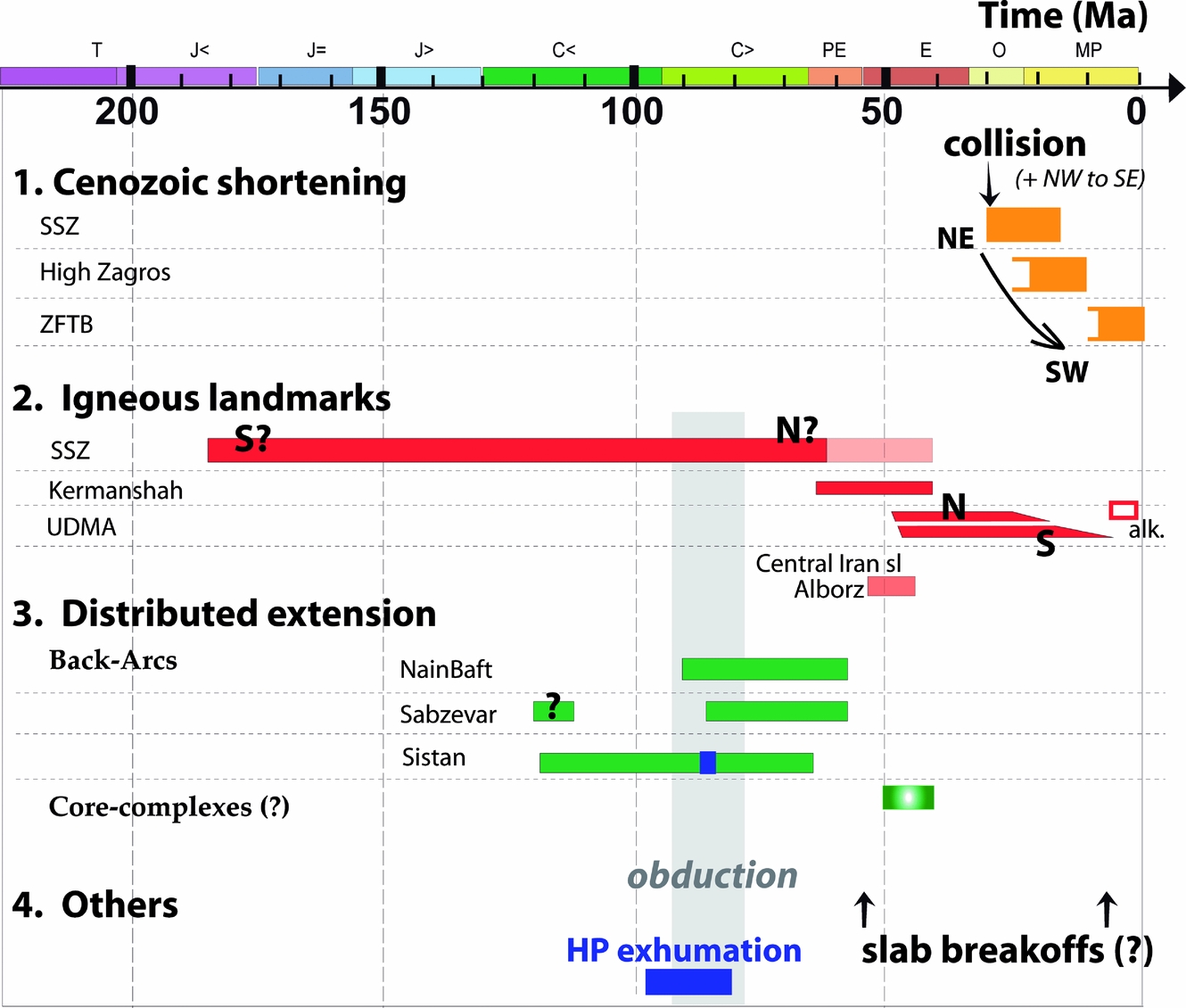
Figure 7. Three main types of tectonomagmatic landmarks are given here to single out major events and important time correlations: collision-related, igneous and extension-related landmarks, respectively, together with other constraints from ophiolites, high-pressure rocks (HP) and possible slab break-off events. See text for details (Section 4).
(1) Collision-related deformation: (i) The start of collision is bracketed within the latest Eocene to Oligocene period (Jolivet & Faccenna, Reference Jolivet and Faccenna2000; Agard et al. Reference Agard, Omrani, Jolivet and Mouthereau2005; Ballato et al. Reference Ballato, Mulch, Landgraf, Strecker, Dalconi, Friedrich and Tabatabaei2010; Section 3.b), but the extent of diachronism along strike is yet unknown. Shortening estimates yield 70–110 km of shortening across the Zagros orogen, from the ZFTB to the SSZ. This amount of shortening over the last 20 Ma (i.e. 3.5 to 5.5 mm yr−1) is comparable to the one deduced from GPS measurements (~ 4–7 mm yr−1; Vernant et al. Reference Vernant, Nilforoushan, Hatzfeld, Abbassi, Vigny, Masson, Nankali, Martinod, Ashtiani, Bayer, Tavakoli and Chery2004). Deformation migrated outwards since the start of collision (Fig. 7).
(ii) The Mio-Pliocene to Quaternary evolution of the ZFTB (~ 10 Ma to present) comprises the uplift of the High Zagros (Gavillot et al. Reference Gavillot, Axen, Stockli, Horton and Fakhari2010), the migration of deformation to the SFB witnessed by growth strata in the Agha Jari Fm (McQuarrie, Reference McQuarrie2004; Mouthereau et al. Reference Mouthereau, Tensi, Bellahsen, Lacombe, Boisgrollier and Kargar2007; Khadivi et al. Reference Khadivi, Mouthereau, Larrasoaña, Vergés, Lacombe, Khademi, Beamud, Melinte-Dobrinescu and Suc2010), a possibly greater implication of thick-skin tectonics from the Pliocene onwards (Molinaro et al. Reference Molinaro, Leturmy, Guezou, Frizon De Lamotte and Eshraghi2005) and a broadening of the orogenic belt (Allen, Jackson & Walker, Reference Allen, Jackson and Walker2004).
(2) Magmatic evolution of the upper plate: (i) Any reconstruction should account for the magmatic shift from the SSZ to the UDMA (Fig. 2a), for their similar mantle source (Fig. 5b), as well as for widespread magmatism throughout Iran during Eocene time (Fig. 2a, d).
(ii) The Paleocene to Early Eocene magmatic activity in the Crush Zone (ETMD; Figs 4a, 5a) is broadly coincident with the temporal shift of magmatism from the SSZ to the UDMA (Fig. 7), and with a slowing down of convergence velocities (Fig. 8a).
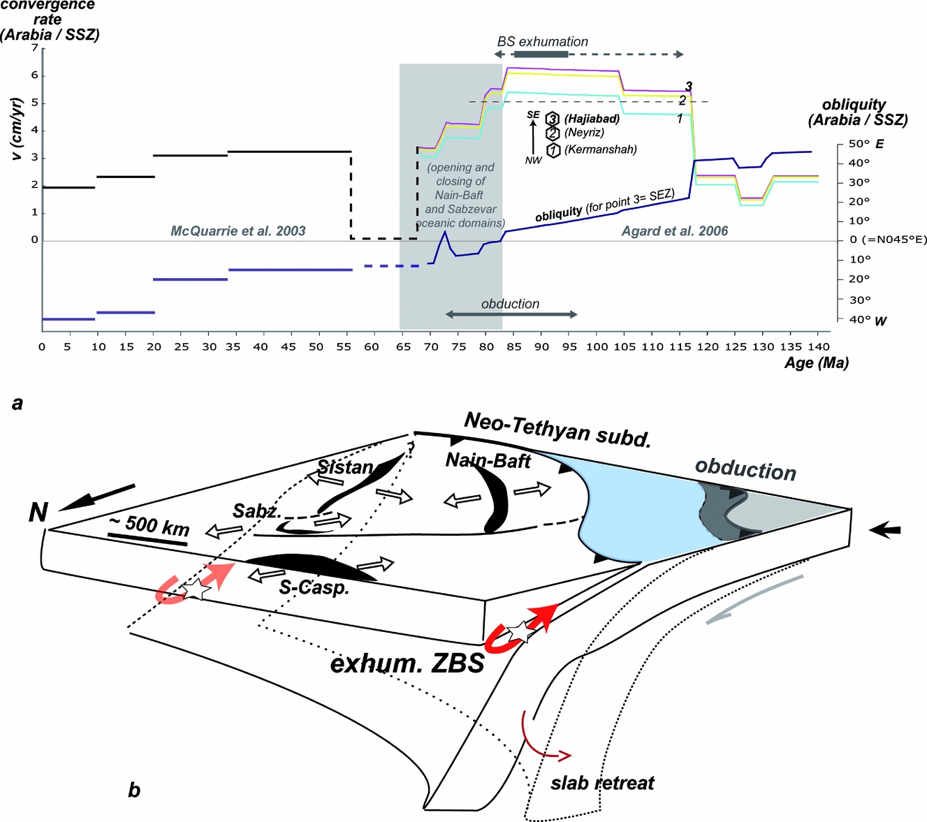
Figure 8. (a) Kinematic constraints for the Zagros convergence. Convergence rates are c. 2–3 cm yr−1 on average except for two noticeable periods: (1) a fast convergence period in the Late Cretaceous (5–6 cm yr−1; 118–80 Ma; it coincides, in the region, with obduction and blueschist exhumation); (2) a very slow convergence period in the Paleocene (see also Dewey et al. Reference Dewey, Helman, Turco, Hutton, Knott, Coward, Dietrich and Park1989 and Rosenbaum, Lister & Duboz, Reference Rosenbaum, Lister and Duboz2002). (b) Outline of the specific constraints provided by the almost coincident onset of regional-scale back-arc opening (see Section 3.e), blueschist (BS) exhumation along the Neo-Tethyan subduction zone (red arrows) and obduction onto Arabia following the c. 115 Ma kinematic reorganization (a). Situation drawn at c. 90–85 Ma. Stretched, partly oceanic basins formed in the upper plate, from north to south: South Caspian (S-Casp.), Sabzevar (Sabz.), Sistan and Nain–Baft seaways.
(iii) Mio-Pliocene adakites form locally along the UDMA (Jahangiri, Reference Jahangiri2007; Omrani et al. Reference Omrani, Agard, Whitechurch, Benoit, Prouteau and Jolivet2008). Although there is widespread Quaternary alkaline magmatism, particularly along fault zones (e.g. Walker et al. Reference Walker, Gans, Allen, Jackson, Khatib, Marsh and Zarrinkoub2009), extensive, recent post-collisional magmatism is only found in the northernmost part of the Zagros orogen (Kheirkhah, Allen & Emami, Reference Kheirkhah, Allen and Emami2009; Chiu et al. Reference Chiu, Zarrinkoub, Chung, Lin, Yang, Lo, Mohammadi and Khatib2010), close to Turkey (where it is well documented; e.g. Keskin, Pearce & Mitchell, Reference Keskin, Pearce and Mitchell1998).
(3) Evidence for distributed extension and links with ophiolite remnants: (i) There is evidence for the formation of core-complexes in Central Iran during Middle Eocene time (Verdel et al. Reference Verdel, Wernicke, Ramezani, Hassanzadeh, Renne and Spell2007) and of an extensional basin in the Alborz (Vincent et al. Reference Vincent, Allen, Ismail-Zadeh, Flecker, Foland and Simmons2005; Guest et al. Reference Guest, Axen, Lam and Hassanzadeh2006; Ballato et al. Reference Ballato, Mulch, Landgraf, Strecker, Dalconi, Friedrich and Tabatabaei2010).
(ii) A number of essentially non-metamorphic ophiolitic remnants (Nain–Baft, Sabzevar, Sistan) are found in the upper plate and interpreted as small back-arc domains formed during Middle–Late Cretaceous time. Their formation coincides with regional-scale kinematic changes, blueschist exhumation and modifications of plate–slab coupling processes (Agard et al. Reference Agard, Monie, Gerber, Omrani, Molinaro, Meyer, Labrousse, Vrielynck, Jolivet and Yamato2006; Monié & Agard, Reference Monié and Agard2009; see Section 5.a and Figs 1b, 8b).
(iii) Obduction-related, Upper Cretaceous ophiolite remnants along the MZT (Kermanshah and Neyriz) differ in ophiolite type and in age. Despite an almost instantaneous regional start of obduction, as suggested by the dating of metamorphic soles (at c. 95 Ma; Hacker, Mosenfelder & Gnos, Reference Hacker, Mosenfelder and Gnos1996; Agard et al. Reference Agard, Jolivet, Vrielynck, Burov and Monie2007), final ophiolite emplacement onto Arabia youngs from Oman to Neyriz and Kermanshah, from Santonian (Searle & Cox, Reference Searle and Cox1999; Agard et al. Reference Agard, Augier and Monié2010) to Maastrichtian (J. Braud, unpub. Ph.D. thesis, Univ. Paris-Sud, 1987; Homke et al. Reference Homke, Vergés, Serra-Kiel, Bernaola, Sharp, Garcés, Montero-Verdù, Karpuz and Goodarzi2009), respectively. The Peri-Arabic obduction is thus not as cylindrical as earlier postulated (Ricou, Reference Ricou1971) and in fact, a significant part (if not all) of what is regarded as the Kermanshah ophiolite is only the sole of the ETMD (Fig. 4b).
5. Lithospheric-scale reconstruction of Zagros geodynamics
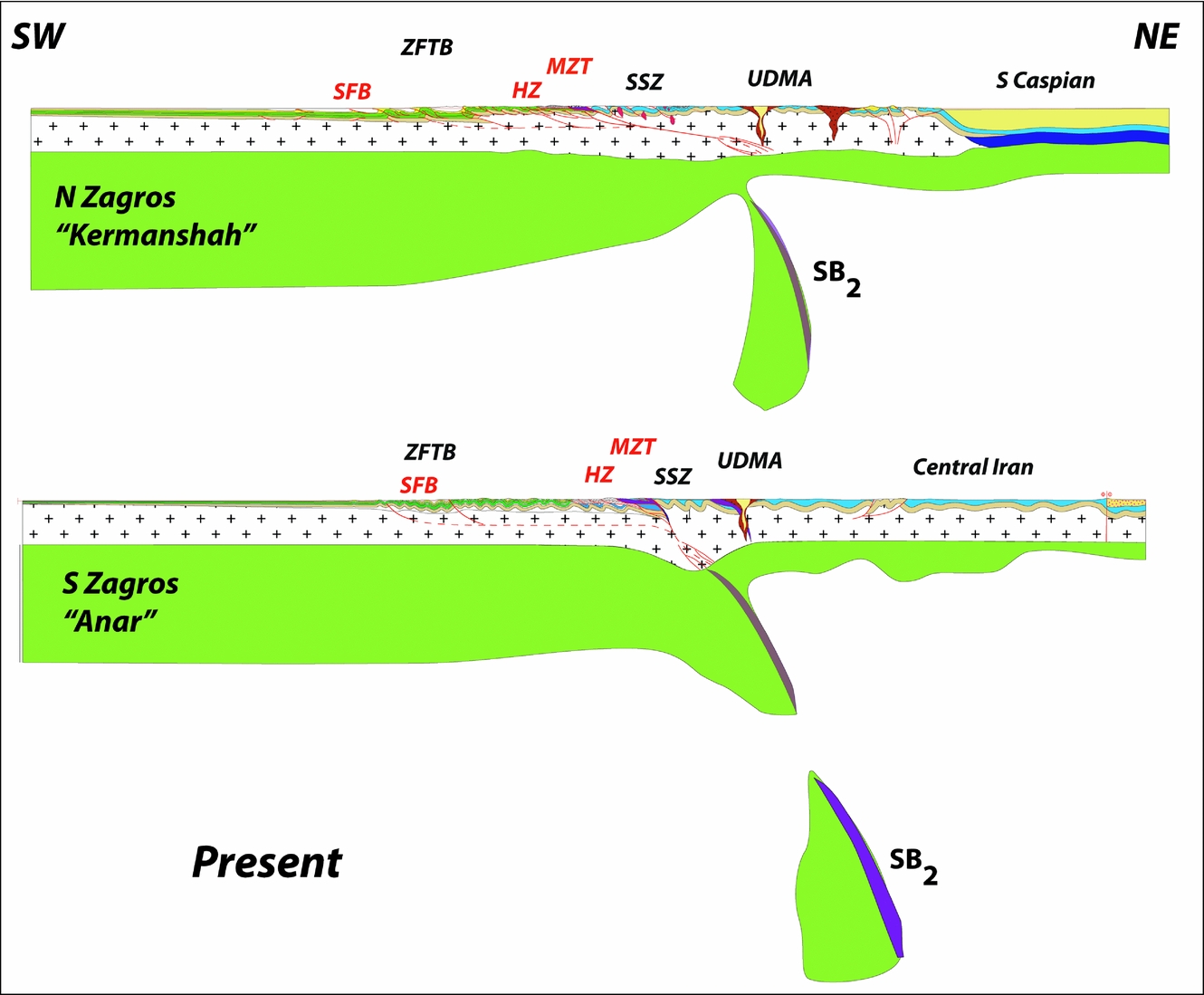
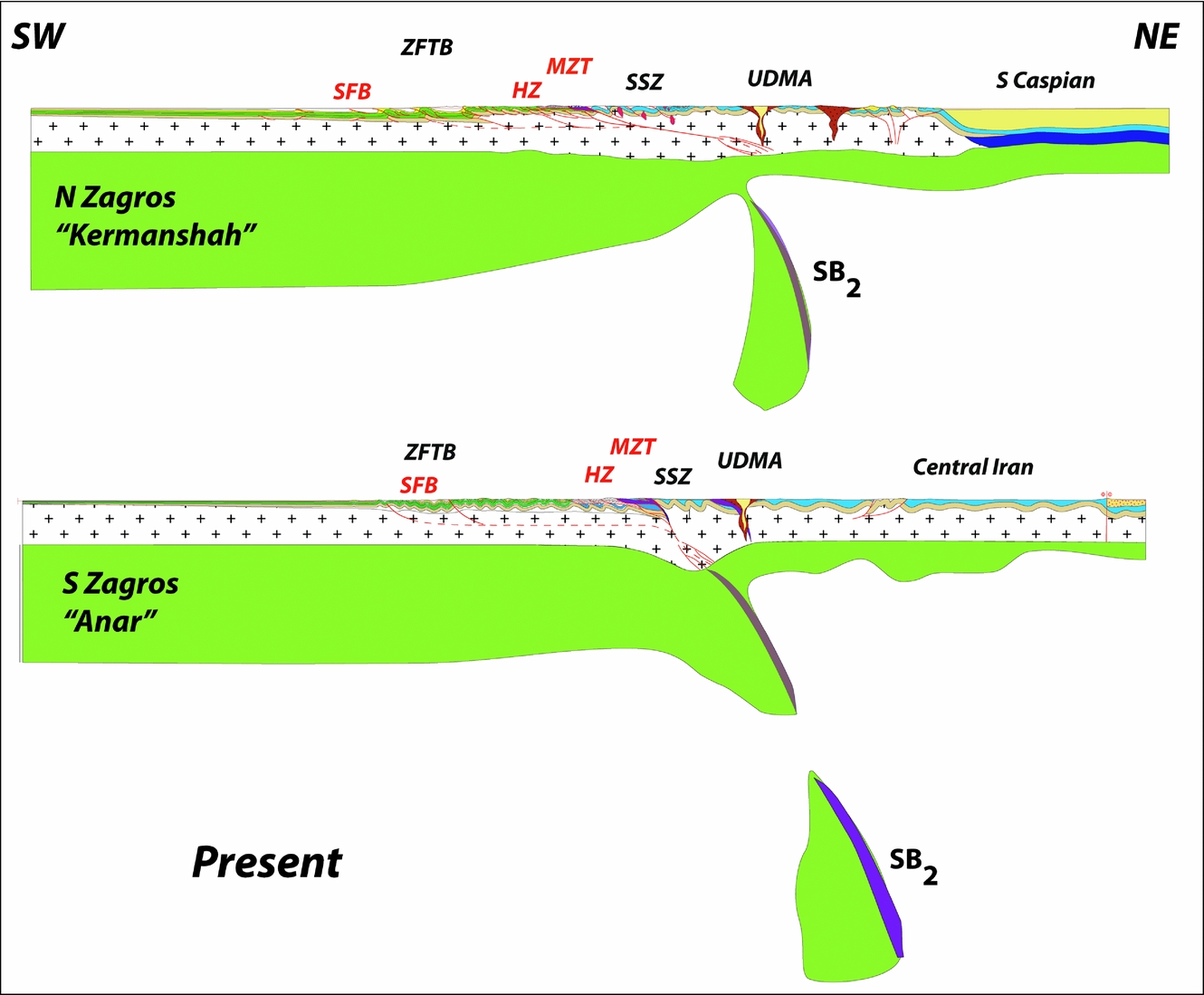
In the following Sections we attempt to reconstruct the evolution of the Zagros orogen along two cross-sections at the scale of the lithosphere (Fig. 9). The northern section (hereafter named ‘Kermanshah’) crosses the whole orogen from the foreland, on the Arabian plate, to the Caspian Sea (Fig. 1c). The second section (‘Anar’) runs from Arabia to Central Iran, across the Deshir and Anar faults (Fig. 1c). The present-day sections were established using all available geological (see previous Sections), kinematic and geophysical information, as explained in the next Sections.
5.a. Geodynamic and geophysical constraints
5.a.1. Key geophysical constraints on present-day structures
The present-day lithospheric and mantle structure below Iran shown in Figure 9 was built from the tomographic sections presented in Figure 6. The large volumes of positive anomalies are interpreted as the signatures of cold anomalies and used to trace the subduction zone beneath Central Iran. Although the resolution of these images is insufficient to show the real shape of the slab at depth, they can be used to see whether a slab is present, whether it is broken or continuous, and to obtain crude estimates of the subducted amounts of lithospheric material (see Hafkensheid, Wortel & Spakman, Reference Hafkenscheid, Wortel and Spakman2006).
For Moho depths across the Zagros and Alborz we used the data of Paul et al. (Reference Paul, Kaviani, Hatzfeld, Vergne and Mokhtari2006, Reference Paul, Hatzfeld, Kaviani, Tatar, Pequegnat, Leturmy and Robin2010) and Radjaee et al. (Reference Radjaee, Rham, Mokhtari, Tatar, Priestley and Hatzfeld2010), respectively. These recent results are consistent with earlier gravimetric constraints (Dehghani & Makris, Reference Dehghani and Makris1984; Snyder & Barazangi, Reference Snyder and Barazangi1986; Alinaghi, Koulakov & Thybo, Reference Alinaghi, Koulakov and Thybo2007). Based on receiver functions, Moho depths are shown to vary from 45 km in the Arabian plate below the Zagros to a maximum of 55 km (in the N-Central Zagros, Kermanshah transect; Paul et al. Reference Paul, Hatzfeld, Kaviani, Tatar, Pequegnat, Leturmy and Robin2010) or 70 km (in the S-Central Zagros, Anar transect; Paul et al. Reference Paul, Kaviani, Hatzfeld, Vergne and Mokhtari2006), with an abrupt gradient below the SSZ in the latter case. Further north, it decreases again beneath the UDMA and the Iranian plateau to reach 42 km (Paul et al. Reference Paul, Kaviani, Hatzfeld, Vergne and Mokhtari2006). Numerous studies point to a fairly thin sub-continental lithosphere below Central Iran (as shown by lower P and S waves and/or high attenuation of Sn waves; e.g. Hafkenscheid, Wortel & Spakman, Reference Hafkenscheid, Wortel and Spakman2006; Kaviani et al. Reference Kaviani, Paul, Bourova, Hatzfeld, Pedersen and Mokhtari2007; Hatzfeld & Molnar, Reference Hatzfeld and Molnar2010), yet not completely delaminated (Paul et al. Reference Paul, Hatzfeld, Kaviani, Tatar, Pequegnat, Leturmy and Robin2010; unlike for Turkey: Pearce et al. Reference Pearce, Bender, De Long, Kidd, Low, Guner, Saroglu, Yilmaz, Moorbath and Mitchell1990; Keskin, Reference Keskin2003; Al-Lazki et al. Reference Al-Lazki, Sandvol, Seber, Barazangi, Turkelli and Mohamad2004, with suggestions of asthenospheric melting at < ~ 80 km depth; Kheirkhah, Allen & Emami, Reference Kheirkhah, Allen and Emami2009; Walker et al. Reference Walker, Gans, Allen, Jackson, Khatib, Marsh and Zarrinkoub2009). By contrast, Priestley & McKenzie (Reference Priestley and Mckenzie2006) pointed to a fairly thick lithospheric root (~ 200 km) below the SSZ. One suggestion is that this may represent lithospheric mantle possibly ponded by convective removal of the sub-continental lithosphere (see discussion in Hatzfeld & Molnar, Reference Hatzfeld and Molnar2010).
Below the Alborz range the Moho depth ranges between 46 and 58 km (Radjaee et al. Reference Radjaee, Rham, Mokhtari, Tatar, Priestley and Hatzfeld2010). Further to the NE, in the South Caspian basin, the Moho keeps a constant depth but the crust is more rigid (Jackson et al. Reference Jackson, Priestley, Allen and Berberian2002) with higher seismic velocities suggesting an oceanic basement overlain by a > 20 km thick sedimentary basin (Mangino & Priestley, Reference Mangino and Priestley1998; Brunet et al. Reference Brunet, Korotaef, Ershov and Nikishin2003; Guest, Guest & Axen, Reference Guest, Guest and Axen2007).
5.a.2. Constraints from kinematic reconstructions
Convergence velocities and obliquity of the Arabian–Eurasian convergence provide the necessary kinematic boundary conditions for any model of Zagros geodynamics (Fig. 8a; Dewey et al. Reference Dewey, Helman, Turco, Hutton, Knott, Coward, Dietrich and Park1989; Dercourt et al. Reference Dercourt, Gaetani, Vrielynck, Barrier, Biju-Duval, Brunet, Cadet, Crasquin and Sandulescu2000; McQuarrie et al. Reference McQuarrie, Stock, Verdel and Wernicke2003; Stampfli & Borel, 2004; Rosenbaum, Lister & Duboz, Reference Rosenbaum, Lister and Duboz2002; Agard et al. Reference Agard, Monie, Gerber, Omrani, Molinaro, Meyer, Labrousse, Vrielynck, Jolivet and Yamato2006; Barrier & Vryelinck, Reference Barrier and Vrielynck2008). It is still unclear, however, when ocean-floor spreading ceases in the Neo-Tethys and if and when there are ridge jumps (Whitechurch et al. Reference Whitechurch, Juteau, Montigny, Dixon and Robertson1984; Ricou, Reference Ricou1994).
Convergence rates are around 2–3 cm yr−1 (Fig. 8a) except for during two noticeable periods: (1) The fast convergence rate in Late Cretaceous time (5–6 cm yr−1; 118–80 Ma) coincides with the well-known quiet magnetic anomaly (Larson, Reference Larson1991), the formation of a super plume below the South Pacific and a general acceleration of oceanic accretion worldwide (Cogné & Humler, Reference Cogné and Humler2004). The regional-scale Late Cretaceous obduction event also takes place during the second half of this period of rapid convergence (Fig. 8a). This acceleration of convergence is thought to have triggered obduction (Agard et al. Reference Agard, Jolivet, Vrielynck, Burov and Monie2007): acceleration would have increased the resistance of the asthenospheric mantle to the subducting Neo-Tethyan slab and transmitted compressional stresses across the lower plate until the formation of a new (and temporary) subduction zone on the southern side of the Neo-Tethys (thereby leading to obduction). The concomitant exhumation of blueschists, from Western Turkey to the Himalayas (~ 3000 km along strike; Figs 1b, 8a), is interpreted as the result of a regional-scale modification of plate–slab coupling in the subduction zone below Eurasia (Monié & Agard, Reference Monié and Agard2009). This major Aptian–Albian kinematic reorganization is also recorded in the sedimentation of the Mesozoic deep-sea carbonates from the southern margin of the Neo-Tethys (Robin et al. Reference Robin, Gorican, Guillocheau, Razin, Dromart, Mosaffa, Leturmy and Robin2010). Figure 8b outlines the specific constraints provided by the almost coincident onset of regional-scale back-arc opening (see Section 3.e.), blueschist exhumation and obduction following the c. 115 Ma kinematic reorganization.
(2) Another distinctive feature of the kinematic history is the very slow Paleocene convergence rate. Both Dewey et al. (Reference Dewey, Helman, Turco, Hutton, Knott, Coward, Dietrich and Park1989) and Rosenbaum, Lister & Duboz (Reference Rosenbaum, Lister and Duboz2002) pointed out this low convergence velocity. Given the uncertainties on velocities it is quite possible that convergence even completely stopped during some 10–15 Ma and resumed afterwards at a rate of ~ 3 cm yr−1 (McQuarrie et al. Reference McQuarrie, Stock, Verdel and Wernicke2003). The convergence velocity then progressively decreased to reach the present 2 cm yr−1. The obliquity of convergence, with respect to the strike of the Zagros orogen, shows a marked evolution too: obliquity sharply decreased after the ~ 115 Ma velocity change, then progressively changed from ~ 115 to ~ 20 Ma (yet staying within 20° of the normal to the present-day strike of the Zagros orogen) before significantly changing again after ~ 20 Ma.
5.a.3. Balancing lithospheric-scale cross-sections
For the palaeogeography and the width of Neo-Tethys Ocean through time we used the information from the Peri-Tethys Atlas (Dercourt et al. Reference Dercourt, Gaetani, Vrielynck, Barrier, Biju-Duval, Brunet, Cadet, Crasquin and Sandulescu2000) and additional constraints provided by Barrier & Vrielynck (Reference Barrier and Vrielynck2008). The suture zone between Arabia and Eurasia is taken to lie along the MZT (i.e. to the south of the SSZ). For crustal shortening across the ZFTB (12–13 km of sediments decoupled from the basement and shortened about 60 km during the last 10 Ma; Fig. 4a), balanced cross-sections of Sherkati, Letouzey & Frizon de Lamotte (Reference Sherkati, Letouzey and Frizon De Lamotte2006) and of Mouthereau et al. (Reference Mouthereau, Tensi, Bellahsen, Lacombe, Boisgrollier and Kargar2007) were used for the Kermanshah and Anar transects, respectively. For the suture zone, we used those of Agard et al. (Reference Agard, Omrani, Jolivet and Mouthereau2005, Reference Agard, Monie, Gerber, Omrani, Molinaro, Meyer, Labrousse, Vrielynck, Jolivet and Yamato2006). In the Alborz, the total amount of (mainly post-Eocene) shortening is estimated to be approximately between 30 and 50 km (H. Nazari, unpub. Ph.D. thesis, Univ. Montpellier II, 2006; Guest et al. Reference Guest, Axen, Lam and Hassanzadeh2006). Little active thickening exists in the Central Iranian plateau (Allen, Jackson & Walker, Reference Allen, Jackson and Walker2004; Morley et al. Reference Morley, Kongwung, Julapour, Abdolghafourian, Hajian, Waples, Warren, Otterdoom, Srisuriyon and Kazemi2009), where deformation is mainly partitioned across the major strike-slip faults (see Section 2.b).
5.b. Lithospheric-scale reconstructions across two transects
We briefly describe the lithospheric evolution of the Zagros through seven stages for each transect (Fig. 10): Late Cretaceous (90 Ma), K–T boundary (65 Ma), Late Paleocene (60–55 Ma), Middle Eocene (45–40 Ma), Late Oligocene (25 Ma), Late Miocene (10 ± 5 Ma) and present day (enlarged in Fig. 9). For the sake of discussion, close-up views of the Kermanshah transect are also given in Figure 11.
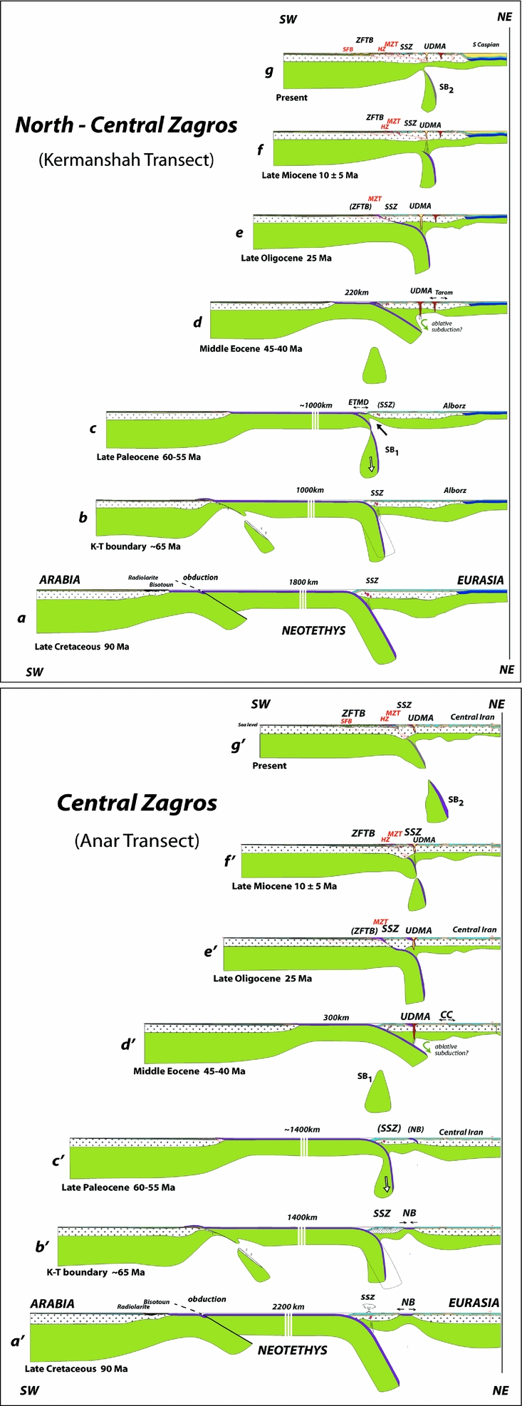
Figure 10. Lithospheric-scale cross-sections across two transects (Fig. 9; location in Fig. 1c). The northern section (a–g; termed ‘Kermanshah’) crosses the whole orogen from the foreland, on the Arabian plate, to the Caspian Sea. The second section (a′–g′; ‘Anar’) runs from Arabia to Central Iran, across the Deshir and Anar faults. The present-day sections were established using all available geological, kinematic and geophysical data (see Section 5.a for details). We selected seven stages for each of the transects: Late Cretaceous (90 Ma), K–T boundary (65 Ma), Late Paleocene (60–55 Ma), Middle Eocene (45–40 Ma), Late Oligocene (25 Ma), Late Miocene (10 ± 5 Ma) and present-day cross-sections (enlarged in Fig. 9). For the sake of discussion, close-up views of the Kermanshah transect are also given in Figure 11. Detailed comments are given in Section 5.b of the text. Abbreviations: CC – core-complex; ETMD – Early Tertiary Magmatic Domain; HZ – High Zagros Fault; MZT – Main Zagros Thrust; NB – Nain–Baft; SFB – Simply Folded Belt; SSZ – Sanandaj–Sirjan Zone; UDMA – Urumieh–Dokhtar Magmatic Arc; ZFTB – Zagros fold-and-thrust belt.
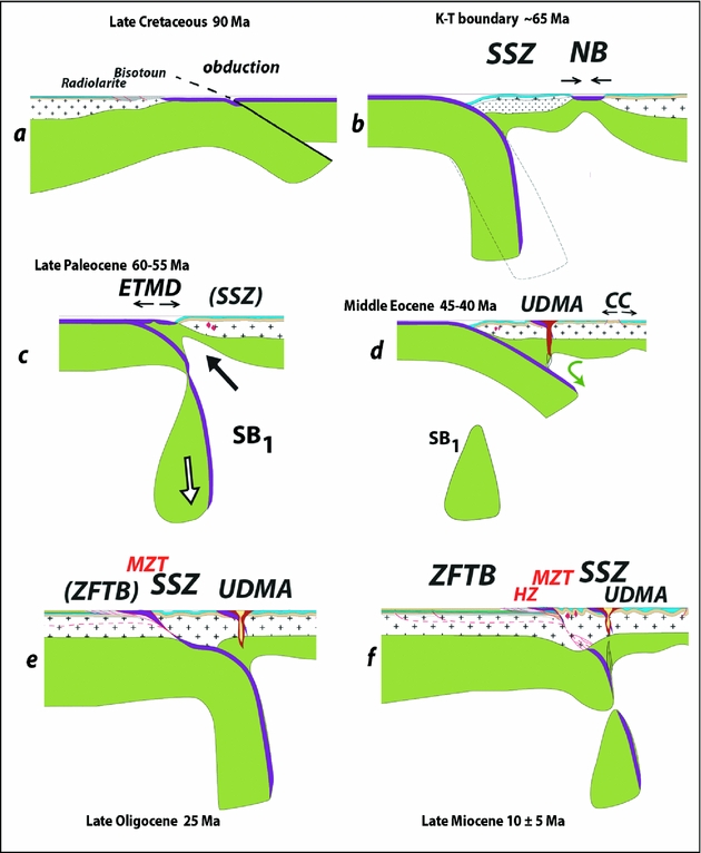
Figure 11. Close-up views of the lithospheric-scale cross-sections presented in Figure 10, emphasizing some of the salient events of Zagros geodynamics (see discussion in Section 6.a). Abbreviations as for Figure 10.
5.b.1. Late Cretaceous (90 Ma)
This first stage (Fig. 10a, a′) corresponds to the period of fast convergence, worldwide high production of oceanic lithosphere and high sea level (Cogné & Humler, Reference Cogné and Humler2004). Subduction is active below the southern margin of Eurasia as indicated by arc magmatism (Figs 2a, 5c), and the width of the Tethys Ocean in this period reaches ~ 1800 km and 2200 km for the Kermanshah and Anar sections, respectively. Regional-scale kinematic changes (fast convergence and reorientation; Fig. 8a) have led to the formation of metamorphic soles at 95 Ma (e.g. Thuizat et al. Reference Thuizat, Whitechurch, Montigny and Juteau1981; Hacker, Mosenfelder & Gnos, Reference Hacker, Mosenfelder and Gnos1996) and to the inception of obduction processes near the southern margin of the Neo-Tethys, following intraoceanic thrusting (Agard et al. Reference Agard, Jolivet, Vrielynck, Burov and Monie2007). Across the Oman transect, the Arabian margin was subducted down to ~ 70 km beneath the oceanic lithosphere (Searle & Cox, Reference Searle and Cox1999; Searle et al. Reference Searle, Warren, Waters and Parrish2004; Yamato et al. Reference Yamato, Agard, Goffe, De Andrade, O. and Jolivet2007). No traces of this deep history are found (or preserved) in Iran. These regional-scale kinematic changes are thought to be responsible for changes in the mechanical coupling in the northern subduction zone below Eurasia, possibly accompanied by slab retreat (Fig. 11b): blueschist units derived from oceanic material are exhumed in this specific time period only (Agard et al. Reference Agard, Monie, Gerber, Omrani, Molinaro, Meyer, Labrousse, Vrielynck, Jolivet and Yamato2006; Monié & Agard, Reference Monié and Agard2009) and small back-arc domains (such as the ~ 90–60 Ma Nain–Baft seaway; Arvin & Robinson, Reference Arvin and Robinson1994) form coevally in the upper plate, in the southern transect (Fig. 10a′).
5.b.2. K–T boundary (65 Ma)
The Neo-Tethys is still consumed beneath the SSZ (Fig. 10b, b′), yet the convergence velocity has already significantly decreased and this period is transitional to the Paleocene slow convergence (Fig. 8a). The cessation of volcanism at the end of this period in the SSZ is consistent with the fact that the slab had already migrated southwards. In the southern transect (Fig. 10b′), the Nain–Baft back-arc basin is progressively closing and will eventually disappear during the Paleocene (Davoudzadeh et al. Reference Davoudzadeh1972; Baroz et al. Reference Baroz, Macaudière, Montigny, Noghreyan, Ohnenstetter and Rocci1984; Arvin & Robinson, Reference Arvin and Robinson1994). Obduction is over on the southern margin of the Neo-Tethys Ocean. Near Kermanshah, the emplacement of oceanic lithosphere onto the continent through obduction has induced the deformation and uplift of the Neo-Tethyan ophiolite and of the Bisotun and radiolarite basins (Fig. 4b), the erosion of which now feeds the Amiran foreland basin (Homke et al. Reference Homke, Vergés, Serra-Kiel, Bernaola, Sharp, Garcés, Montero-Verdù, Karpuz and Goodarzi2009). In the southern parts of the Zagros, near Neyriz, similar conditions prevailed (Ricou, Reference Ricou1971); obducted ophiolites resting on top of Coniacian units there are well preserved, however (unlike along the Kermanshah section; Fig. 4b), and are unconformably overlain by Maastrichtian limestones.
5.b.3. Late Paleocene (60–55 Ma)
This period is characterized by extremely slow convergence (Fig. 8a). The width of the Neo-Tethys during Paleocene time is thus not very different from that in the latest Cretaceous (Fig. 10c, c′). The ETMD (Crush Zone, Kermanshah region) attests to an intraoceanic arc located at the foot of the Eurasian margin until Early–Middle Eocene time (Figs 4b, 5a, 10c) and coincides with a time gap between the end of the SSZ main magmatic activity and the onset of volcanism in the UDMA (Fig. 7). The Late Cretaceous slab roll-back probably accounts for the outwards migration of arc magmatism. In order to account for the ETMD magmatism itself, we propose a slab break-off and the melting of the metasomatized sub-continental lithosphere (with a subduction component) in response to heat provided by the asthenospheric window (Fig. 11c; Keskin, Reference Keskin2003; Benoit et al. Reference Benoit, Aguillon-Robles, Calmus, Maury, Bellon, Cotten, Bourgois and Michaud2002). Slab break-off is favoured by slow convergence, which enhances the relative downward traction of the relatively stagnant slab, and is common in the Neo-Tethys history (Wortel & Spakman, Reference Wortel and Spakman2000; Mahéo et al. Reference Mahéo, Guillot, Blichert-Toft, Rolland and Pêcher2002). As already noted, a marked geodynamic contrast nevertheless exists between the north and south Zagros transects (Fig. 10c, c′): no Paleocene arc or Amiran flysch are found in the south, whereas the Nain–Baft basin (closed in Paleocene time) does not extend to the north (see Section 6.c).
5.b.4. Middle Eocene (45–40 Ma)
The ocean width decreased fast again from Eocene time onwards. After the Paleocene–Early Eocene slab break-off, the piece of oceanic lithosphere still attached to Arabia subducted with a lower dip, thus explaining the inwards volcanic arc migration towards the UDMA, where it remains until today (Figs 10d, d′, 11d). The resumption of subduction-related, widespread calc-alkaline magmatism in the UDMA (with a geochemical signature similar to the SSZ), together with the Paleocene slab break-off and its thermal consequences, could explain in part the widely distributed volcanism over much of Iran (Fig. 2a). Intense magmatic activity below the UDMA, together with the change of overall deformation patterns to extension (Fig. 7), may indeed have triggered magma ascent in the weak, deformable zones of the upper plate, in particular around large-scale faults of Central Iran.
5.b.5. Late Oligocene (25 Ma)
At the end of Oligocene time, Arabia and Eurasia have collided and the oceanic crust has completely disappeared (Fig. 10e, e′). Final resorption of the oceanic domain took place after 35 Ma and collision started before c. 25–23 Ma in the northern Zagros (Agard et al. Reference Agard, Omrani, Jolivet and Mouthereau2005; Allen & Armstrong, Reference Allen and Armstrong2008; Homke et al. Reference Homke, Verges, Van Der Beek, Fernandez, Saura, Barbero, Badics and Labrin2010). Incipient collision leads to the deformation of the SSZ and the Crush Zone, which are shortened by about 40 km (Agard et al. Reference Agard, Omrani, Jolivet and Mouthereau2005). The last marine sediments (Lower Miocene Qom Fm) lie unconformably on both the Crush Zone nappe stack and the SSZ (Fig. 4b). The SSZ was actually largely shortened prior to the Qom sedimentation, before deformation propagated to the SW. Continental collision is first accommodated by subduction of the Arabian continent beneath the SSZ; this accounts for the disappearance of the distal part of the Arabian margin (Molinaro et al. Reference Molinaro, Leturmy, Guezou, Frizon De Lamotte and Eshraghi2005; Mouthereau et al. Reference Mouthereau, Tensi, Bellahsen, Lacombe, Boisgrollier and Kargar2007) and for crustal thickening below the SSZ (Paul et al. Reference Paul, Kaviani, Hatzfeld, Vergne and Mokhtari2006, Reference Paul, Hatzfeld, Kaviani, Tatar, Pequegnat, Leturmy and Robin2010). Significant exhumation takes place in the SSZ during the first stages of collision (Fig. 4a; fission-track data at 28–25 Ma; J. Omrani, unpub. Ph.D. thesis, Institut des Sciences de la Terre, Paris, Reference Omrani, Agard, Whitechurch, Benoit, Prouteau and Jolivet2008; Homke et al. Reference Homke, Verges, Van Der Beek, Fernandez, Saura, Barbero, Badics and Labrin2010), and volcanism is still active in the UDMA, but much less so than during Eocene time (Fig. 2e).
5.b.6. Late Miocene (10 ± 5 Ma)
The Miocene period (Fig. 10f, f′) is a prelude to the present situation. The deformation has decreased in the SSZ and the Crush Zone and started to propagate towards the external zones of the Zagros. A rough balance of shortening suggests that, from 15 to 7–8 Ma, the external zone was shortened by about 10 km while the SSZ and the Crush Zone shortened by some 30 km. A noticeable change in volcanism happens in the southern segment of the UDMA with the formation of adakites in the Anar region (Figs 4a, 5e). These adakites correspond to slab melting as a result of a second slab break-off (Omrani et al. Reference Omrani, Agard, Whitechurch, Benoit, Prouteau and Jolivet2008). Tomographic images (Fig. 6) indicate that the slab is effectively detached below Central Iran in the Anar region, possibly to a greater extent than in the north along the Kermanshah transect. Recent numerical models suggest a delay time of 10 to 20 Ma for slab break-off after the start of collision (Van Hunen & Allen, Reference Van Hunen and Allen2011), which would be consistent with the timing of this break-off at 10 ± 5 Ma (Molinaro, Zeyen & Laurencin, Reference Molinaro, Leturmy, Guezou, Frizon De Lamotte and Eshraghi2005; Omrani et al. Reference Omrani, Agard, Whitechurch, Benoit, Prouteau and Jolivet2008).
5.b.7. Present
The present-day cross-section is recalled here for comparison (Fig. 10g, g′). Shortening has largely stopped in the SSZ and the Crush Zone since 7–8 Ma and mainly occurs in the ZFTB, which has shortened by about 60 km since. Adakitic magmatism continued up to Plio-Quaternary time along the Anar segment (Omrani et al. Reference Omrani, Agard, Whitechurch, Benoit, Prouteau and Jolivet2008; Chiu et al. Reference Chiu, Zarrinkoub, Chung, Lin, Yang, Lo, Mohammadi and Khatib2010), while in the other parts of UDMA a normal calk-alkaline volcanism occurred. The underthrusting of Arabian crust, which started with the onset of collision during Oligocene time, led to thickening of the crust beneath the SSZ to a maximum of 70 km (Paul et al. Reference Paul, Kaviani, Hatzfeld, Vergne and Mokhtari2006, Reference Paul, Hatzfeld, Kaviani, Tatar, Pequegnat, Leturmy and Robin2010).
6. Discussion
6.a. Geodynamics of Arabia–Eurasia convergence across the Zagros
These lithospheric-scale reconstructions account for most of the key events outlined in Section 4 (see also Fig. 7) and allow us to highlight three critical time periods:
(1) Mid to Late Cretaceous (115–85 Ma; Fig. 10a–b/a′–b′): this period comprises back-arc basin formation in the upper Eurasian plate, with small oceanic domains cutting across Central Iran (Nain–Baft, Sabzevar, Sistan), blueschist exhumation along the northern Neo-Tethyan subduction zone and obduction processes in the southern part of the Neo-Tethyan domain (see Fig. 8b). Neo-Tethyan slab retreat, a process generally promoted in subduction zones by increased convergence velocities (Conrad, Bilek & Lithgow-Bertelloni, Reference Conrad, Bilek and Lithgow-Bertelloni2004; Schellart et al. Reference Schellart, Freeman, Stegman, Moresi and May2007; Funiciello et al. 2008), is thought to have triggered the formation of these back-arc domains.
(2) Paleocene–Eocene (60–40 Ma; Fig. 10c–d/c′–d′): the beginning of this period is marked by a slowing down of convergence (Fig. 8a) following slab retreat, and by a generalized slab break-off along the Zagros orogen. This combination results in an outwards magmatic shift from the SSZ to the Kermanshah region (and possibly near Neyriz; Babaie et al. Reference Babaie, Ghazi, Babaei, La Tour and Hassanipak2001). By contrast, the end of this period witnesses an inwards magmatic shift (from the Kermanshah and the outer rim of the SSZ) to the UDMA and a surge in magmatic activity, probably related to the resumption of oceanic subduction below Eurasia. We propose that the distributed Middle Eocene magmatism and extension (core-complexes in Central Iran, extensional basins in the Alborz) results from enhanced coupling between the two plates and ablative subduction (flow-driven suction of the sub-continental lithosphere leading to partial delamination and melting; Fig. 10d, d′; Pope & Willett, Reference Pope and Willett1998). Extension in the overriding plate could also, alternatively, result from the resumption of slab roll-back accompanying the renewed, effective subduction after slab break-off. Note that the above pre-collisional stages have either occurred without much construction of regional topography or the associated relief has been almost entirely erased to allow for the deposition of the Lower Miocene Qom Formation. In any case, the current topography largely results from the subsequent collisional stage.
(3) From Oligocene time onwards (35–30 Ma to present; Fig. 10e–h/e′–h′): collision starts and leads to a progressive SW migration of shortening and orogenic build-up: a significant uplift successively affected the SSZ (20–15 Ma), the High Zagros (10 Ma) and the SFB (5–0 Ma). A second slab break-off leading to the formation of adakites during Late Miocene time (Omrani et al. Reference Omrani, Agard, Whitechurch, Benoit, Prouteau and Jolivet2008; Fig. 5e) took place below Central Iran (see also Molinaro, Zeyen & Laurencin, Reference Coleman2005; Paul et al. Reference Paul, Hatzfeld, Kaviani, Tatar, Pequegnat, Leturmy and Robin2010), and probably migrated towards the NW in the light of tomographic constraints (Fig. 6) and adakite ages (younging northwards from c. 9 to 1 Ma; Chiu et al. Reference Chiu, Zarrinkoub, Chung, Lin, Yang, Lo, Mohammadi and Khatib2010). This slab break-off at ~ 10 Ma below part of Central Iran and eastern Turkey (Keskin, Pearce & Mitchell, Reference Keskin, Pearce and Mitchell1998) probably contributed to the flare up in magmatism across much of the orogen (Fig. 2f). It may also have contributed to the reorganization of collision from the Pliocene onwards (e.g. Allen, Jackson & Walker, Reference Allen, Jackson and Walker2004) through an increased coupling between the two plates (‘head on’ collision once slab pull is removed); an amplification of collisional movements is indeed noted in the Fars arc from 8–7 Ma onwards (Homke et al. Reference Homke, Vergès, Garcés, Emami and Karpuz2004, Reference Homke, Verges, Van Der Beek, Fernandez, Saura, Barbero, Badics and Labrin2010).
Our interpretation in terms of slab break-off and change of slab dip recalls the earlier suggestion from Berberian & Berberian (Reference Berberian, Berberian, Gupta and Delany1981, fig. 12), but differs from their interpretation in that: (i) magmatism at first did not migrate inwards but outwards (Kermanshah) before being located beneath the UDMA, (ii) magmatism in the Tarom–Alborz region is in fact coeval with magmatism in the UDMA (thus not requiring a slab steepening and swinging back as in Berberian & Berberian, Reference Berberian, Berberian, Gupta and Delany1981), and (iii) closure had already happened in Mid-Miocene time.
From estimates of slab material at depth, Hafkenscheid, Wortel & Spakman (Reference Hafkenscheid, Wortel and Spakman2006) concluded that they could not distinguish between a reconstruction broadly similar to ours (which they referred to as ‘scenario II’; Dercourt, Ricou & Vrielynck, Reference Dercourt, Ricou and Vrielynck1993) and the one from Stampfli & Borel (Reference Stampfli and Borel2002; ‘scenario III’). These scenarios are further tested here (Fig. 12). In scenario II, obduction develops as a result of intraoceanic subduction to the south of the Neo-Tethys (Fig. 12b), whereas in scenario III ridge subduction below Eurasia triggers an early slab break-off and the formation of an extensive marginal basin, which is ultimately obducted (Fig. 12c; Stampfli & Borel, Reference Stampfli and Borel2002). Figure 12b–c underlines that domains with high velocity material at depth can be accounted for by the two models and that both imply two stages of slab break-off (SB1, SB2; Fig. 12b, c), yet at different times. Our scenario (II) is preferred, however, for the following reasons: ridge subduction-related SB1 in scenario III would have to happen very early, at c. 95–90 Ma; scenario III does not account for the migration of magmatism from the SSZ to the UDMA, requires new subduction initiation at the foot of Eurasia and predicts a more voluminous slab material below Eurasia than scenario II; finally, scenario II alone explains the ETMD magmatic activity in the Kermanshah region (K, Fig. 12b). The back-arc basin noted ‘S’ (Fig. 12c) may, alternatively, be taken as representing the ETMD itself and having been accreted to Eurasia, but this would make it too old (unless only the latest magmatic products are accreted) or too distant from the continental margin (J. Braud, unpub. Ph.D. thesis, Univ. Paris-Sud, 1987).

Figure 12. (a) Volume estimates of slab material at depth, after Hafkenscheid, Wortel & Spakman (Reference Hafkenscheid, Wortel and Spakman2006), and possible location of the oceanic and continental lithospheres at present and during Eocene time (40 Ma). (b) Scenario ‘II’ using Dercourt, Ricou & Vrielynck's (Reference Dercourt, Ricou and Vrielynck1993) hypothesis, adapted from Hafkenscheid, Wortel & Spakman (Reference Hafkenscheid, Wortel and Spakman2006). This scenario is implicitly considered in our reconstructions (Figs 10, 11). (c) Scenario ‘III’ using Stampfli & Borel's (Reference Stampfli and Borel2002) hypothesis, adapted from Hafkenscheid, Wortel & Spakman (Reference Hafkenscheid, Wortel and Spakman2006). Abbreviations: AR – Arabia; EU – Eurasia; K – Kermanshah; NT – Neo-Tethys; obd – obduction; R – ocean ridge; S – Semail; SB1 or 2 – slab break-off 1 or 2; AI, Eg, Ir, SA, SI, Zs – abbreviations for volume estimates of slab material at depth after Hafkenscheid et al. Reference Hafkenscheid, Wortel and Spakman2006.
6.b. Further clues for regional geodynamics?
A number of points should be clarified by future research:
(a) The widespread Eocene magmatism throughout Iran (Fig. 2d). In principle this could result from mantle delamination below Iran (although this is not supported, at least at the scale of the whole of Iran, by the seismic profiles of Paul et al. Reference Paul, Hatzfeld, Kaviani, Tatar, Pequegnat, Leturmy and Robin2010) or from abundant subduction-related magma ascent through (extensional) deforming areas of the upper plate. We envision an intermediate hypothesis, whereby extension within the upper plate (as indicated in the crust by core-complex formation in Central Iran and extension in the Alborz) relates to vigorous, ablative subduction (as a result of the entrance of a more shallow-dipping slab after SB1) with traction-driven flow (and/or rapid thermal convection in a low viscosity asthenospheric mantle; Currie et al. Reference Currie, Wang, Hyndman and He2004; Dilek, Altunkaynak & Oner, Reference Dilek, Altunkaynak, Oner, Ring and Wernicke2010) leading to only partial removal of the lithospheric mantle below Iran.
The alkaline Oligocene magmatism in Sistan could also tentatively be related to localized mantle upwellings triggered by slabs resting on the 660 km discontinuity, as proposed by Faccenna et al. (Reference Faccenna, Becker, Lallemand, Lagabrielle, Funiciello and Piromallo2010). Given subduction rates, the Neo-Tethyan slab still subducting after SB1 would indeed touch the discontinuity approximately 20 Ma afterwards, hence approximately at 35–30 Ma (i.e. in Early Oligocene time or when Zagros collision started). Note, however, that the Sistan part of this widespread Eocene magmatism (Fig. 2d) could be completely unrelated to the Neo-Tethys and could result, instead, from slab break-off after closure of the small Sistan ocean. More geochemical data on the Late Eocene–Early Oligocene magmatism are thus clearly needed.
(b) Possible causes of the reorganization of collision since 10 ± 5 Ma (Allen, Jackson & Walker, Reference Allen, Jackson and Walker2004; Homke et al. Reference Homke, Vergès, Garcés, Emami and Karpuz2004; Molinaro et al. Reference Molinaro, Leturmy, Guezou, Frizon De Lamotte and Eshraghi2005; Ballato et al. Reference Ballato, Mulch, Landgraf, Strecker, Dalconi, Friedrich and Tabatabaei2010). This reorganization and broadening of the Zagros orogen could result from an increased coupling between the two plates as a result of slab break-off (Omrani et al. Reference Omrani, Agard, Whitechurch, Benoit, Prouteau and Jolivet2008), from a change in the nature of the collision owing to the implication of an unstretched Arabian crust with normal thickness (Ballato et al. Reference Ballato, Mulch, Landgraf, Strecker, Dalconi, Friedrich and Tabatabaei2010), from a regional-scale kinematic reorganization from 5 Ma onwards (Axen et al. Reference Axen, Lam, Grove, Stockli and Hassanzadeh2001; Smit et al. Reference Smit, Brun, Cloetingh and Ben-Avraham2010a) and/or from a positive climatic feedback (Allen & Armstrong, Reference Allen and Armstrong2008).
(c) Why is there so little left (if anything) of the obducted ophiolite along the Zagros range (Fig. 4b)? The Oman ophiolite is well preserved because it has escaped collision so far, but large obducted ophiolite sheets were preserved in Turkey after collision (Okay, Harris & Kelley, Reference Okay, Harris and Kelley1988). We speculate that this may relate to the initial 3D configuration (even in Oman, differences exist between the NW and the SE of the ophiolite); either less underthrusting of the continent (and therefore less obduction) or the underthrusting of a highly stretched continental margin below the ophiolite would indeed not favour a large isostatic rebound and future ophiolite preservation.
(d) What is the exact timing of inception of subduction? There are at present indications that subduction was active by 180–170 Ma, but more data is needed to tell whether subduction initiation took place during Late Triassic or Early/Middle Jurassic time.
(e) Has the Zagros orogen undergone long-lived deformation partitioning? Evidence for protracted (mainly dextral) shear indeed exists: Late Cretaceous in the SSZ (Mohajjel & Fergusson, Reference Mohajjel and Fergusson2000; Mohajjel, Fergusson & Sahandi, Reference Mohajjel, Fergusson and Sahandi2003; Sarkarinejad, Reference Sarkarinejad2007), Oligocene in the Crush Zone (Agard et al. Reference Agard, Omrani, Jolivet and Mouthereau2005), Oligo-Miocene in the High Zagros (Axen et al. Reference Axen, Fakhari, Guest, Gavillot, Stockli and Horton2010) and at present across the whole of Iran (ZFTB and the Kazerun fault system, Kopet Dagh, etc; Talebian & Jackson, Reference Talebian and Jackson2002; Authemayou et al. Reference Authemayou, Chardon, Bellier, Malekzadeh, Shabanian and Abbassi2006).
6.c. A case study for upper plate deformation in a subduction context
Our reconstructions of Arabia–Eurasia convergence across the Zagros point to the importance of mechanical coupling between the two plates in two critical time periods: Late Cretaceous and Late Paleocene. Upper plate deformation represents a useful proxy for plate–slab coupling and subduction zone behaviour (Funiciello et al. Reference Funiciello, Faccenna, Giardini and Regenauer-Lieb2003; Conrad, Bilek & Lithgow-Bertelloni, Reference Conrad, Bilek and Lithgow-Bertelloni2004; Lallemand, Heuret & Boutelier, Reference Lallemand, Heuret and Boutelier2005; Regard et al. Reference Regard, Bellier, Thomas, Abbassi, Mercier, Shabanian, Feghhi and Soleymani2004): Lallemand et al. (Reference Lallemand, Heuret, Faccenna and Funiciello2008) recently concluded that back-arc opening (or compression) develops if the upper plate velocity is larger (or smaller) than a certain threshold fraction of the lower plate velocity. Friction along the interplate contact and the mantle Stokes reaction acting on the slab are indeed the two main forces competing against slab pull (Arcay, Lallemand & Doin, Reference Arcay, Lallemand and Doin2008). However, whether such changes may be regularly taking place through time, and on which time scale, is completely unknown.
The Arabia–Eurasia convergence across the Zagros provides an interesting case study and points to time-scale changes in upper plate deformation of the order of 5–10 Ma: (1) Mid-Cretaceous extension marked by back-arc opening, mechanical decoupling along the subduction zone with blueschist exhumation and initiation of slab roll-back; (2) Late Cretaceous to Paleocene contraction, as testified by the closure of the back-arc domains; (3) Paleocene/Early Eocene extension, at least in the Kermanshah area (J. Braud, unpub. Ph.D. thesis, Univ. Paris-Sud, 1987), probably coincident with slow convergence and stagnant steep slab detachment (SB1); (4) Early Eocene compression (?) accompanying the increase in convergence velocities; (5) Middle Eocene extension throughout the whole upper plate (as testified by core-complexes and extensional volcanic basins); extension may be driven by renewed, efficient subduction traction (or, alternatively, by slab break-off below the tiny back-arc domains, or both), and could be analogous to the late Mesozoic geodynamics of the eastern border of China (Charles et al. Reference Charles, Gumiaux, Augier, Chen, Lin, Faure and Zhu2009); (6) Late Eocene/Early Oligocene contraction (Kargaranbafghi, Neubauer & Genser, Reference Kargaranbafghi, Neubauer and Genser2010), which is broadly coincident with the onset of collision; (7) intensification of shortening from Late Miocene time onwards (10–5 Ma to present).
Notwithstanding the need for more geological data (i.e. exact upper plate tectonic configuration during late Mesozoic time; see Saccani et al. Reference Saccani, Delavari, Beccaluva and Amini2010), it is also worth pointing out the contrasts between regions to the north and south of the Zagros orogen, on either side of a line running along the Kazerun and Doruneh faults, approximately (Fig. 13; see also Fig. 10a–g and a′–g′). These 3D contrasts and along-strike variations can probably be accounted for by the complex interaction between inherited structures (from Palaeo-Tethyan closure times in Late Triassic time and even earlier), back-arc fragmentation and collision along the Zagros.

Figure 13. Snapshot maps showing some of the salient tectonic and magmatic events affecting the Eurasian upper plate and Central Iran, with emphasis on the geological contrasts found on either side of the Doruneh fault (compilation from available data cited in text). Reconstructions for Iran and the Neo-Tethys adapted from Barrier & Vrielynck (Reference Barrier and Vrielynck2008). Abbreviations: AE – Alborz extension; Am F – Amiran flysch; BS – blueschist; CC – core-complex; DF – Dezful fault; HZT – High Zagros thrust; K – Kermanshah; N – Neyriz; NB – Nain-Baft; NGF – Nayband and Gowk faults; OBD – obduction; P – Piranshar; SB – slab break-off; Sabz. – Sabzevar; SCB – South-Caspian Basin; SF – Sistan Fault; ZF – Zagros thrust front; MZT, SSZ, UDMA – as for Fig. 1c, e.
6.d. Constraints for (Neo-Tethyan) orogens
We finally discuss a possible comparison of the Zagros orogen with the well-studied, adjacent Neo-Tethyan orogens from Turkey, the Himalayas and the Western Alps. A detailed comparison between the Zagros and the Himalayas in terms of plateau and orogenic build-up was recently provided by Hatzfeld & Molnar (Reference Hatzfeld and Molnar2010). These authors concluded to similar processes operating during orogeny despite a less mature collision for the Zagros than for the Himalayas, primarily owing to differences in convergence velocities.
This type of comparison may prove difficult to generalize owing to important, first-order specific boundary conditions for each orogen: for example, the widespread extension in the Western Mediterranean domain after 35–30 Ma strongly influenced the later development of the collision in the Western (and to some extent Central) Alps, as did the escape of Anatolia for Turkey since Pliocene time or the much greater convergence velocities for the Himalayas (pre-collision convergence velocities with respect to Eurasia of 11 and 3 cm yr−1 for India and Arabia, respectively). Table 1 nevertheless attempts to provide some general statements, in part focusing on complementary aspects to those noted by Hatzfeld & Molnar (Reference Hatzfeld and Molnar2010). Table 1 shows that, by comparison with the Alps, the other three (Turkey, the Zagros and the Himalayas) have evolved into mature mountain belts, with collision-related plateaus (whose elevation broadly correlates with the duration of collision) underlain by significant heat flow, and share a typical time scale for slab break-off of 20–30 Ma.
Table 1. Comparison of the Zagros orogen with the well-studied, adjacent Neo-Tethyan orogens from Turkey, the Himalayas and the Western Alps

Slab break-off after von Blanckenburg & Davies (Reference Von Blanckenburg and Huw Davies1995), Mahéo et al. (Reference Mahéo, Guillot, Blichert-Toft, Rolland and Pêcher2002) and Keskin (Reference Keskin2003) and references therein, for the Alps, Himalayas and Turkey, respectively. SKS below Zagros taken from Kaviani et al. (Reference Kaviani, Hatzfeld, Paul, Tatar and Priestley2009). See Section 6.d for discussion. Symbols: +++, ++, +, − stand for large, moderate, some or none, respectively.
In Tibet, models of plateau formation include crustal thickening and successive intracontinental subductions triggered by lithospheric strike-slip fault propagation (e.g. Meyer et al. Reference Meyer, Tapponnier, Bourjot, Métivier, Gaudemer, Peltzer, Shunmin and Zhitai1998; Tapponnier et al. Reference Tapponnier, Xu, Roger, Meyer, Arnaud, Wittlinger and Yang2001) or bulk lithospheric shortening and subsequent removal of thickened lithospheric mantle (e.g. England & Houseman, Reference England and Houseman1989; Molnar, England & Martinod, Reference Molnar, England and Martinod1993). In the Iranian plateau, there is neither evidence for a generalized sub-continental mantle delamination nor for any intracontinental subduction. The lack of present-day normal faulting in the Iranian plateau precludes extensional collapse (as noted by Hatzfeld & Molnar, Reference Hatzfeld and Molnar2010). From our present-day knowledge of magmatism, the Iranian plateau may thus resemble E Turkey, where magmatism and deformation take place through a mixture of slab break-off, mantle delamination and strike-slip faulting (Keskin, Reference Keskin2003; Al-Lazki et al. Reference Al-Lazki, Sandvol, Seber, Barazangi, Turkelli and Mohamad2004; Keskin, Genç & Tüysüz, Reference Keskin, Genç and Tüysüz2008; Sengör et al. Reference Sengör, Sinan Ozeren, Keskin, Sakink, Ozbakir and Kayan2008). Such complex magmatic patterns are now recognized below W Turkey too (Dilek & Sandvol, Reference Dilek, Sandvol, Murphy, Keppie and Hynes2009; Dilek, Altunkaynak & Oner, Reference Dilek, Altunkaynak, Oner, Ring and Wernicke2010). Future research should therefore aim at better documenting gradients in magmatic type such as were reported for Turkey (i.e. increase of the slab component from north to south; Keskin, Pearce & Mitchell, Reference Keskin, Pearce and Mitchell1998; Keskin, Reference Keskin2003). By contrast to Turkey, however, there does not seem to be (yet) a major slab tear such as that advocated by Facenna et al. (Reference Faccenna, Bellier, Martinod, Piromallo and Regard2006) to allow for the tectonic escape of Anatolia (Flerit et al. Reference Flerit, Armijo, King and Meyer2004).
An interesting specificity of the Zagros orogen (Table 1) may be that, although the strong influence of early, subduction stages is still largely visible (as discussed above), there are (1) only limited remnants of obduction or HP oceanic units, (2) no metamorphic relicts of continental subduction returned (although much of the distal margin of Arabia was subducted and is missing; Molinaro et al. Reference Molinaro, Zeyen and Laurencin2005; Mouthereau et al. Reference Mouthereau, Tensi, Bellahsen, Lacombe, Boisgrollier and Kargar2007), (3) no collision-related MP–MT metamorphism and therefore only moderate crustal stacking despite ~ 30 Ma of collision.
The absence of exhumation of the HP/UHP subducted continental margin (contrary to all other Neo-Tethyan belts; Table 1) may be due to the obducted ophiolite load onto Arabia (but Turkey and the Himalayas had a similar one), to the entrance of a highly thinned (and therefore not very buoyant) continental margin or, more likely, to insufficient slab pull provided by the remnant lithosphere sinking between the two slab break-offs (Figs 10d, d′, 12b). Alternatively, we note that there was no such microcontinental block (easier to subduct) as the Bitlis–Püturge in Turkey, nor were the velocities as great as in the Himalayas (but HP/UHP developed in the Alps with very slow convergence velocities!).
Relatively minor crustal stacking at depth at present below the Zagros (as revealed by only localized crustal thickening, below the SSZ, and the lack of MP–MT metamorphism) may hypothetically be related to insufficient slab pull too (as discussed above). This may relate to a much less mature orogeny than Turkey or the Himalayas, and one may wonder, in particular, why it takes 15–20 Ma for deformation to build-up in ZFTB. Ballato et al. (Reference Ballato, Mulch, Landgraf, Strecker, Dalconi, Friedrich and Tabatabaei2010) recently suggested that this may represent the lag time between the initiation of continental collision (35–30 Ma; ‘soft’ collision with the stretched Arabian lithosphere) and the acceleration of regional deformation (~ 15–10 Ma; ‘hard’ collision, when the unstretched Arabian lithosphere comes in). One may also think of a contribution from the Late Miocene slab break-off (SB2), which significantly reduces slab pull and will favour more frontal collision (Omrani et al. Reference Omrani, Agard, Whitechurch, Benoit, Prouteau and Jolivet2008; Van Hunen & Allen, Reference Van Hunen and Allen2011). The comparison with the Alps, however, where the uplift of the external crystalline massifs (in a way similar to the High Zagros) also takes ~ 20 Ma but does not coincide with slab break-off (Von Blanckenburg & Huw Davies, Reference Von Blanckenburg and Huw Davies1995; Table 1), suggests that this contribution may be small (or that Alpine slab break-off was comparatively limited).
7. Conclusions
We herein provide a review of our present knowledge of the Zagros orogeny and clues to Zagros geodynamics. We outline three main periods/regimes:
(1) Mid to Late Cretaceous time (115–85 Ma) corresponds to a distinctive period of perturbation of subduction processes and interplate mechanical coupling marked by blueschist exhumation and upper plate fragmentation;
(2) Paleocene–Eocene time (60–40 Ma) witnesses slab break-off, major shifts in arc magmatism and distributed extension within the upper plate;
(3) From Oligocene time onwards (30 ± 5 Ma to present), collision develops with a progressive SW migration of deformation and topographic build-up (SSZ: 20–15 Ma, High Zagros: ~ 12–8 Ma; SFB: 5–0 Ma), and is accompanied by a second, Late Miocene slab break-off (~ 10 Ma to present).
The Zagros shares similarities in orogenic build-up with neighbouring mountain belts developed at the expense of the Neo-Tethys (Alps, Turkey, Himalayas). Significant differences, on the other hand, include limited remnants of obduction or HP oceanic units, lack of continental subduction remnants and limited crustal stacking at depth despite ~ 30 Ma of collision. Another great difference with adjacent belts is that the Zagros orogen preserves an exceptional record of upper plate deformation, which should help better understand mechanical coupling between plates, with changes through time in the order of 5–10 Ma.
The Zagros orogeny thus appears intimately linked with the closure of the Neo-Tethys, from subduction/obduction processes to present-day collision (from ~ 150 to 0 Ma), and our reconstructions underline the key role played by oceanic subduction throughout the whole convergence history (see also Faccenna & Becker, Reference Faccenna and Becker2010). More generally, we finally stress that such a long-lasting subduction system with changing boundary conditions makes the Zagros orogen an ideal natural laboratory for subduction processes.
Acknowledgements
P. Agard acknowledges the support, over the years, from the Geological Survey of Iran (GSI) and the MEBE programme. This paper builds upon the Ph.D. of Jafar Omrani and later developments. The incentive for this paper also partly comes from solicitations from Y. Dilek (through the GSA Tectonic crossroads meeting; October 2010, Ankara) and O. Lacombe (this volume). Both are warmly thanked for triggering the write-up of this long-due manuscript. J. Omrani acknowledges the additional support from the French embassy in Tehran for a short stay in Paris, which was essential too. S. L. Chung and M. Zarrinkoub are thanked for lending us an early version of the results of Chiu et al. (Reference Chiu, Zarrinkoub, Chung, Lin, Yang, Lo, Mohammadi and Khatib2010). Reviews by M. Allen and M. Searle helped improve the manuscript. Warm thanks to J. Smit for discussion and corrections.