

The shortest route from the capital of Iran, Tehran, to Chalus on the Caspian Sea is by the road which crosses the Elburz Mountains by a pass at a height of 3,000 m. (Figs. 1 and 2). The “Chains Highway”, as it is called, is kept open throughout the year. Nearly every winter avalanches occur on the higher parts of the road and cars are damaged by them. On 11 February 1959 a bus and two trucks were overtaken by an avalanche and 26 persons lost their lives (see Fig. 3, p. 981). As a result of this, His Excellency General V. Ansari, Director of the Ministry of Roads and Communications, initiated a study of the best way of avoiding such tragedies in the future. Since the budget for technical assistance from the United Nations Organization did not allow for the employment of an additional expert, it was suggested by His Excellency the Swiss Ambassador, Dr. A. Marcionelli, and the Swiss engineer, Dr. E. Zipkes, Technical Assistance Office adviser on highway construction to the United Nations Organization, that in accordance with the terms of the Iranian-Swiss bilateral agreement on technical assistance the Swiss Government should delegate an expert to study the avalanche and snowdrift problems for three months during the winter of 1959–60.
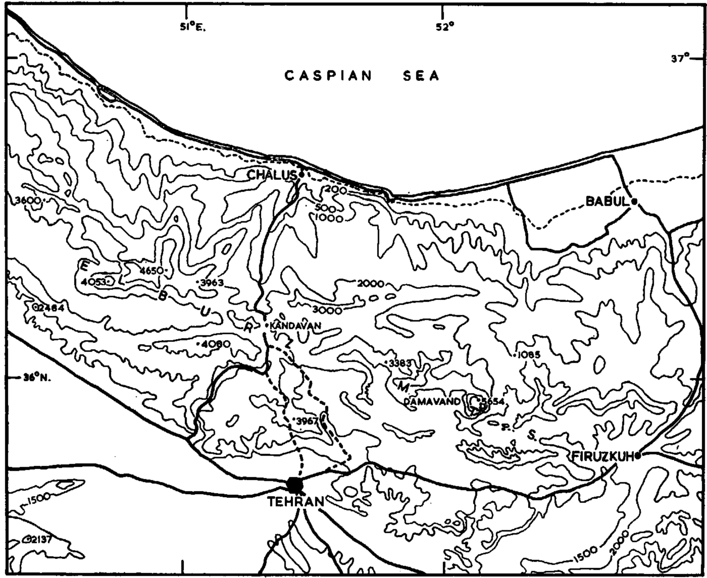
Fig. 1. Map of narthcïn Iran showing the extent of the Elburz Mountains, the general topography of the area between Tehran and the Caspian Sea. and the route of the “Chalus Highway”. Heights in metres
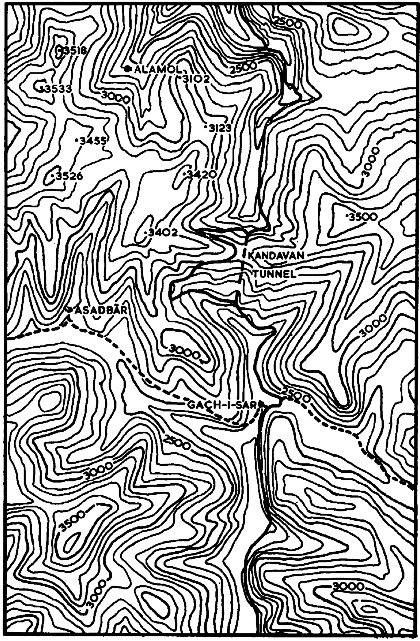
Fig. 2. The detailed topography of the area in the vicinity of the Kandavan tunnel, where the “Chalus Highway” is most exposed to avalanches. The scale of the map is given by the tunnel which is 2 km. long. Heights in metres

Fig. 3. A general view of the Elburz Mountains from the eastern slopes of point 3,420 m., north-west of the Kandaran tunnel, from a height of about 3,200 m. looking towards the north-north-east. The part of the road in the foreground of the photograph is between 2,500 and 2,650 m. high and traverses northward to Chalus. Beyond point 1on the left of the photograph the road bends to the right behind the corner to the Zangoule bridge. Point 1 is the site of the accident of 11 February 1959. The peak on the right has a height of about 3,800 m. and the mountains on the left of the photograph are about 3,400 m, high. There was very little snow during the winter 1959–60 and fortunately there were no accidents due to avalanches. The snow remains on north-facing slopes where there is further accumulation by the southerly wind. The photograph was taken in March 1960
This study was confined to three main roads:
-
The road from Tehran via Firuzkuh to the Caspian Sea, north-east from Tehran (Fig. 1).
-
The protection of the road from Tehran to Tabriz (north-west Iran, near Lake Rezaieh) against snowdrift.
The most important of these problems was the first-named.
The annual average precipitation at Tehran is 20 to 30 cm. of water, at Chalus it is about 150 cm. of water, and in the vicinity of the mountain pass between the two towns it is 30 to 50 cm. of water. Assuming that half the precipitation falls as snow, a summation of each fresh snow layer gives about 2 m. of snow. However, there would seldom be such a thickness of snow cover, because it packs, melts and sublimates during the periods between snowfalls.
The section of the road most exposed to avalanches is about 15 km. in length, from Gach-i-Sar in the south to the Zangoule bridge in the north (Fig. 2). At both places the road is at an elevation of 2,300 m. and rises to 2,700 m., where it crosses the watershed through the 2 km. Iong Kandavan tunnel. In summer it is possible to drive over the pass which is only 300 m. higher (Fig. 4, p. 982).

Fig. 4. A view of the Elburz Mountains and the pass across them (right background) from a point north of the Kandavan tunnel at a height of 2,600 m. The road coming in from the right at point 2 is the summer road over the mountain pass (3,050 m.). This road would only be cleared and made suitable for traffic in the summer f repairs to the tunnel were necessary. The track of an avalanche (indicated by arrows) and suggested protection for the lower road are also shown. The photograph was taken in March 1960
The prevailing wind, which is usually from the south, prevents the snow from accumulating on slopes facing the south, south-east or south-west. Also, the very hot sunshine melts the snow on these slopes. The dangerous mountain slopes are those facing north, north-east and northwest, where enormous quantities of snow accumulate as a result of winds during storms. In these areas, where the mountain tops rise to a height of 3,400 m., the greatest possible vertical sweep of an avalanche may be about 900 m.
In these areas the best protection against avalanches are galleries. Four of them with a total length of 140 m. exist already. The exposed section of the road was studied carefully and sixteen places were found which were susceptible to being overrun by dangerous avalanches. The best possible protection was suggested for each place and included possibly cheaper defences, for instance, fences to hold the snow on the slopes or dams to brake the striking force of the moving snow masses. New galleries with a total Iength of 575 m. were proposed for ten places and at three places dams were suggested. Shooting with a mortar when necessary was considered sufficient for the three remaining places.
Over a distance of 3 km. the Firuzkuh road is exposed to avalanches which descend a much shorter slope than on the Chalus road. It therefore seemed that deflecting fences, using the wind to disturb the snow, would be a sufficient protection.
The protection of the road from Tehran to Tabriz against snowdrift was dealt with by the methods suggested by Pugh.Reference Pugh 1 In mountainous areas the morphology complicates the problem of snowdrift so considerably that it is always advisable to erect some experimental deflectors to check their efficiency before planning the final project.
I wish to thank all the engineers of the Iranian Highway Department who helped me in my work.


