

Introduction
The Chhota Shigri glacier (32°11′−32°8′N and 77°30′ −77°33′E) lies within the monsoon arid transition zone (Reference Krenak, and Bhawan,Krenak and Bhawan, 1945) in the Lahaul–Spiti District, Himachal Pradesh, India (Fig. 1). It is considered to be a potentially sensitive indicator of the northern limits and intensity of the monsoon. Its fluctuations, of the order of 19–20 m either advance or retreat, have been observed since 1986 (Reference Kumar, and Dobhal,Kumar and Dobhal, 1994).

Fig. 1. Location map of the glacier with some salient features of Chhota Shigri glacier.
Chhota Shigri is a transverse glacier descending 9 km northwards from the Pir Panjal Range in the main Chandra River valley of Himachal Himalaya. The accumulation zone lies at 4650–5900 m. The equilibrium line (ELA) fluctuates between 4650 and 4800 m. The maximum width of the glacier is 1.5–1.8 km near the ELA. The snout is narrow, steep, covered by debris and bounded by escarpment walls (Fig. 2), dropping at an angle of 35° through the ablation zone to the snout at 4100 m a.s.l.; extending about 1 km over morainic alluvium deposits. The glacier is fed by four tributaries, three on the eastern side and one on the west. The total glacierized area is 18.6 km2 with ice in the main glacier stream occupying about 8.6 km2. Thickness varies from 15–130m from the snout to the accumulation zone (Fig 3), according to a gravity survey. The average flow velocity is 8.58 m a−1, ranging from 8.1 m a−1 in the ablation zone to 13.81 m a−1 at the ELA (Reference Dobhal,Dobhal, 1992). The temperature varies from −4.5° to 11° C at the ELA in August– September to 4.5° to 19° C at the Snout. There are no surface streams in the basin; discharge is entirely due to melting of the glacier.

Fig. 2. Longitudinal profile along the eastern and western side of the glacier valley, cross-profile of the valley (U-shaped) showing the toe of the glacier resting on pulverized material.

Fig. 3. Thickness of the ice determined by a gravity method in 1988. The ice-depth contour plotted from the ice thickness with a 10 m contour interval and cross-section XIV taken to calculate the velocity distribution components.
Climate
The Himalaya form the southern limits of the Tibetan Plateau. This 5–7 km elevated region has an enormous influence on the natural environment and on its adjacent regions. The high plateau causes many changes in the atmospheric column, such as a differential heating effect which is low near the plateau and warm high above it. It intercepts the sub-tropical planetary high-pressure zone and has a direct affect on the Indian monsoon (Reference Jijun, Shuying, and Miller.Li and Xu, 1984). During the monsoon months wind speed varies from 10–20 ms−1 in the Himalaya (Fig. 4). The mean 600 m bar chart for July 1200 GMT, averaged over the period 1961–70, shows troughs falling over southern Tibet and on the northern and southern sides of the Tibetan plateau (Fig. 5), hence producing glaciers in the Himalaya which are very active. When the westerly circulation is more southerly, and becomes blocked over the plateau in the winter months, the thermo-dynamic effect causes abundant precipitation, as rain and snow, over the western Himalaya. The Himalayan glaciers are not only large but, lying at very low latitudes, are very temperate. It is evident that temperature plays an important role in the rapid fluctuations of a glacier. This is indicated by data on mass changes in the Chandra Valley system, collected in 1986–89 (Table 1; stations A and B), which show considerable climatic variation.
Table 1. Meteorological characteristics on Chhola Shigri glacier during the summer season (August– September) 1986–89 from field measurements at 3870 m (station A) and 4650 m (station B)
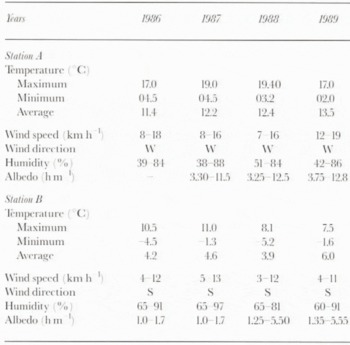

Fig. 4. Annual variation of wind speed at 12 km on the south (broken line) and north (solid line) side of the plateau (after Reference Gao, Tang, Luo and ShenGao You-Xi and others, 1981).

Fig. 5. Mean 600 m bar chart for July averaged over the period 1961–70 in geopotential decameters. 1200 GMT (after Reference Gao, Tang, Luo and ShenGao You-Xi and others, 1981).
The major pattern of the glacier regime controlled by climate has been identified. Glacier melt takes place mainly from advection, and this process of melling during the summer season occurs both day and night. Precipitation increases at low altitudes, below 3870 m a.s.l., but at 4650 m the influence of the summer is reduced. Wind flow in the glacier valley is generally from the south and southwest, whereas in the main valley it is mainly westerly where it forms eddy currents (Fig. 6). The temperature here is higher than at the glacier where the melling rate is 2– 4 cm d−1. The mass-balance trend was negative for 1987–88 and 1988–89; −1.01 × 10⁶ m3 and −1.71 × 10⁶ m3, respectively (Reference Dobhal,, Kumar, and Muudepi,Dobhal and others, 1995).
The diurnal variation of temperature is comparatively greater. The temperature is higher in the main Chandra Valley than at the Chhota Shigri glacier, such that the glacier is up to −1.6° to 5° C cooler in the summer months (August). Mean relative humidity varies from 73 to 93% in the valley, which is more at the glacier. Energy-budget calculations near the ELA give a snow melt rate of 0.5 cm d−1. The environmental lapse rate ranges from 5.3° to 14.7° C km−1 but is mostly scattered around 12° C km−1 (Reference Purohit,, Rajput,, Roy, and Sharma,Purohit and others, 1989).

Fig. 6. Formation of the eddy current at the junction of the glacier valley (south and south-southwest) and the main Chandra Valley (westerly) wind-flow direction.
Bedrock Geology
Chhota Shigri glacier lies within the Central Crystallines of the Pir Panjal range of the Himachal Himalaya (Fig. 7). This Crystalline axis is comprised mostly of meso- to ketazonal metamorphites, migmatites and gneisses. In places, granitic rocks of different composition and younger age indicate rejuvenation. But 3km upstream of Chhota Dara, in the upper Chandra valley, older Palacozoic granitic rocks are exposed. The Haimanta Formation overlies these with a tectonic break, where black slates, phyllites and fine-grained biolite-schists are exposed. The slates and phyllites show a well-developed thrust tectonic contact which forms the crest of the northern ridge. Box-type folds with décollement are quite prominent in the Haimanta Formation.

Fig. 7. Geological map of the area around Chhota Shigri glacier (after Reference Rawat, and Purohit,Rawat and Purohit, 1988). gneiss have developed in the granite without any distinct margins (Reference Kumar,Kumar, 1979, Reference Kumar,1996). Chhota Shigri glacier rests on the granitic basement rocks
The Haimantas, which rest directly on basement rocks, are highly metamorphosed metasediments and show intense folding and shearing. The brown biotite, with a fine-grained texture, shows intense heating effects which indicates periodic reheating of the granitic rocks below. This is also indicated by the various types of granitic and gneissic rocks present in the basement. Schistose gneiss and augengeneiss have developed in the granite without distinct margins Reference Kumar,Kumar, 1979, Reference Kumar,1996) Chhota Shigri glacier rests on the granitic basement rocks
On both sides the ridge tops are at an altitude of 6300 m and the bottom of the Chandra Valley lies at 3300 m. The overall relief is 3000 m.
Geomorphological Aspects and Glacial Limits
Time and again it has been postulated that in this region there are more than three levels of erosion, belonging to more than three different cycles, related to several tectonic events separated from each other in time and space. The erosional features provide a good observational setting for assessing:
-
1. The influence of the present glaciation on the higher areas and the valley climate.
-
2. Controls related to bedrock geology and structure.
In the Himalaya, the Neoglacial moraine complexes are generally preserved above the present termini at 4300 m, but this limit varies with the average height of the region. They are quite prominent, sharp and multi-crested, steepwalled complexes up to 150 m thick and very close to the present glacier snouts. Chhota Shigri glacier has four such sharp crests, which higher up are disturbed by solifluction debris but lower down are disturbed by minor slips within the morainic complex and rockfalls over it. The moraines show a high degree of mechanical weathering due to the extremes of climate. High wind velocities causes desert varnishing. Boulder-faceted soil development in the morainie debris is quite prominent. Considering these characteristics with respect to their position, the moraines can be attributed to a recessional stage of the last glaciation (Fig. 8).

Fig. 8. Five recessional stages of the glacier from last glaciation.
The most interesting observation on the snout of Chhota Shigri glacier and the lower part of the ablation zone is that the section about 800–1000 m from the snout rests on debris deposited by glacier movement at its toe, i.e. glacial moraine or till (Fig. 6). These moraines are mostly quite thick (>50 m) and rest on a hard rock base, but in the lowest parts they are >100m thick and represented by a poorly consolidated till. As is clear from Figure 9, the Chhota Shigri glacier moraine has an exceptional crest, higher than the present level of the Chandra River. The latter has three distinct levels of terraces at intervals of –50 m (Fig. 9). Glacier flow does not appear to have increased the morainic deposits but there is a crest in the valley which is a recent phenomenon. These moraine levels contain “fresh” boulders exhibiting limited surface weathering. However, the maximum advance of the terminal moraines has been correlated with the last glaciation.

Fig. 9. Three distinct levels of the river terraces of the Chandra River at intervals of 50–60 m. This indicates that Chhota Shigri Glacier has an exceptionally higher crest than the present level of the Chandra River.
Discussion
It is clear from the climate data that the Himalayan glaciers cannot be compared to the Alpine ones (Table 1). The main difference is the orientation of the mountain ranges. North-to-south cold winds can affect climatic Conditions in the Alps, but have a lesser effect in the Himalaya. It is also clear that the orographically controlled climatic gradient due to the Tibetan Plateau, tectonic uplift and contrasting glacier geometries all had a direct affect on the Pleistocene glaciation in the Himalayan region.
Active tectonism in the Himalaya, and the long-fault lineament controlling the east-west river valleys Opening to the south of the ranges in the Indo-Gangetic plains, play an important role in controlling melt at the snouts of the glaciers, or the fluctuations during a year. The lower glacier limits, which extend onto the morainic debris, and melt with respect to the variations in the main valley temperatures, are controlled by high winds from the Indian plains flowing along the valleys. While glacier extension is based on snow accumulation in the region and the available snowfields. snout fluctuations depends on temperature variations at the junction of two valleys and in the unconsolidated morainic debris below the glacier ice (Fig. 6). In the Himalaya, few glaciers flow over rocks, most have lower snouts extending over glacial deposits, depending on the extension depth and the shape of the valleys, which further control the glacier shape and geometries.
Calculated velocity-distribution components at different cross-sections of Chhota Shigri glacier are given in Table 2
(Fig. 3) Cross-section VI shows the maximum surface velocity and ice discharge and can be inferred as the equilibrium line, separating the ablation and accumulation zones. Even the extraordinary high rate of Vb/V s (up to 92%) in the ablation zone indicates that basal sliding, controlled by the ice mass and the slope, is the main mechanism of glacier movement. However, the bare upper surface does show some capillary action, i.e. waxing and waning.
Table 2. Calculated glacier thickness and component velocity along the central line of the glacier in 1987 and 1988 (Reference Dobhal,Dobhal, 1992)

Conclusion
The recent study of Chhota Shigri glacier showed a thinning in the middle part by 3 m during 2 years (i.e. 1987 and 1988). A gravity survey indicated the glacier was comparatively thicker on the western side than in the middle part. The maximum thickness of the glacier on the western side indicates the glacier valley is much more inclined or deeper on that side, which may be due to bending of the glacier and more erosion. Regarding the movement of the glacier, the high rate of V b/V s in the ablation area indicates that basal sliding is the main movement mechanism, meltwater contributes more to its movement in the north-northeast direction.
Acknowledgement
The authors are grateful to the Director, WIHG, Dehra Dun, for the opportunity to carry out the present work. Financial assistance from DST, Ministry of Science and Technology, Government of India, New Delhi, under the Himalayan Glacier Programme, is gratefully acknowledged.


