

In 1949 the writers made a reconnaissance study of the Moreno and Ameghino Glaciers in the Patagonian Andes. These studies were initiated by the American Geographical Society and the Museo Argentino de Ciencias Naturales “Bernardino Rivadavia” as part of a program of glaciological study being carried out in both halves of the Western Hemisphere.Reference Nichols and Miller 1
The investigations showed that between 1870–80 the Ameghino Glacier reached a more advanced position than it had occupied in hundreds of years; since that time it has retreated several hundred yards to its present position. 2 About 5 kilometers south of the Ameghino, on the other hand, the Moreno Glacier was found to be advancing into a mature forest along its northern edge. In a recent publication Heim shows that the Moreno Glacier has in general been advancing since the turn of the century.Reference Heim 3
This paper records the few observations made on the Moreno Glacier and considers why the terminus of one glacier may be advancing while that of a nearby glacier is retreating.
The Moreno Glacier
Description
The Moreno GIacier, in the Lago Argentino district of Southern Patagonia, flows eastward from the more or less continuous ice field that extends along the Patagonian Andes from roughly lat. 50° 25′ S. to lat. 51° 25′ S. (Figs. 1 and 2, p. 43).
4
It terminates in Canal de los Témpanos, an arm of Lago Argentino, in a magnificent vertical ice barrier between 15–30 m. high and approximately 5 km. long (Figs. 3, p. 40, and 4, p. 39). The glacier is about 15 km. long, and where it enters the lake is approximately![]() km. wide. The almost complete absence of morainal material on its surface makes it unusually white and clean. When seen in March 1949 the barrier seemed alive as great masses of ice were continuously calving off, generating lake waves, some of which were more than 1 m. high. The calving and cracking of the ice sounded like artillery and thunder, and could be heard a few kilometers away. The writers were told that at times the noise is so great it is painful to the ear drums. Besides being greatly crevassed, the glacier is covered with ice pinnacles, many of which appear to be curved. As there was no opportunity to study these features it is not known whether this shape is the result of curved shear planes or crevasses, differential melting, plastic adjustment, or some other factor or factors. Where calving is not active the barrier is undercut at lake level and there are also numerous caves (Fig. 3). These features are due mainly to wave action and to melting by the warm surface waters of the lake at places of structural weakness. They are common on the more inactive ice barriers and on old icebergs in the Antarctic.
km. wide. The almost complete absence of morainal material on its surface makes it unusually white and clean. When seen in March 1949 the barrier seemed alive as great masses of ice were continuously calving off, generating lake waves, some of which were more than 1 m. high. The calving and cracking of the ice sounded like artillery and thunder, and could be heard a few kilometers away. The writers were told that at times the noise is so great it is painful to the ear drums. Besides being greatly crevassed, the glacier is covered with ice pinnacles, many of which appear to be curved. As there was no opportunity to study these features it is not known whether this shape is the result of curved shear planes or crevasses, differential melting, plastic adjustment, or some other factor or factors. Where calving is not active the barrier is undercut at lake level and there are also numerous caves (Fig. 3). These features are due mainly to wave action and to melting by the warm surface waters of the lake at places of structural weakness. They are common on the more inactive ice barriers and on old icebergs in the Antarctic.

Fig. 1 Location map of the Lago Argentino area

Fig. 2 Map of the Lago Argentino area, showing location of the Moreno, Ameghino, Upsala and other glaciers (after Dr. Egidio Feruglio)

Fig. 3 Panorama of the Moreno Glacier taken 5 March 1949. Canal de los Témpanos on the right and Lago Rico on the left are connected by a channel which is not seen in the photograph and which cuts across the glacier. The stagnant piece of ice in the foreground is separated from the active glacier in the background by this channel (see text p. 41)

Fig. 4 The barrier of the Moreno Glacier where it terminates in Logo Argentino (see text p. 41)
On its north side, a short distance from the lake, the Moreno Glacier is advancing into a mature forest consisting of trees hundreds of years old (Fig. 5, p. 39) Many trees, some with leaves still attached, are lying on the glacier and scores of trees have recently been knocked over and killed. The glacier at this place is in a more advanced position, therefore, than any it has occupied for hundreds of years. According to Senor Benito S. Colqui of the Argentine Department of Hydrology, the glacier advanced laterally 20 m. up-slope in this area from 22 April 1948 to 10 December 1948.

Fig. 5 Trees with leaves still attached lying on the northern edge of the Moreno Glacier (see text p. 42)
A piece of stagnant ice which was completely detached from the Moreno Glacier was located at the foot of Buenos Aires Mt. in March 1949 (Fig. 6, p. 45). This detached piece of ice was approximately 120 m. long, 60 m. wide and 20 m. high. It had a snout terminus and between it and the active ice of the glacier was a channel about 40 m. wide connecting Canal de los Témpanos and Lago Rico (Fig. 7, p. 40). This stagnant ice was formed a few years earlier when the glacier advanced completely across the lake and terminated at the foot of Buenos Aires Mt. At this time an ice-dammed lake was probably formed on the upstream side of the Moreno Glacier in the Lago Rico and Brazo Sur areas of Lago Argentino (Fig. 2). Later the channel was formed, the impounded waters escaped, the levels of the water in Canal de los Témpanos, Lago Rico and Brazo Sur became equalized, and the terminus of the glacier was left stranded at the foot of Buenos Aires Mt. The stagnant ice is probably in line with the axis of greatest motion of the glacier and will soon be destroyed by ablation as it is far below the snow line.

Fig. 6 Longitudinal cross section of the terminus of the Moreno Glacier. The active ice, the channel cut across the toe of the glacier, the stagnant block of ice and the recently glaciated area are shown

Fig. 7 Channel cut through the toe of the Moreno Glacier. Stagnant block of ice on the right, active glacier on the left (see text p. 42)
History
The history of the Moreno Glacier since 1900 has recently been reviewed by Heim. 5 The terminus of the glacier was 750 m. from the foot of Buenos Aires Mt. in 1900, 350 m. in 1908, approximately 100 m. in 1914, and it reached Buenos Aires Mt. in 1917 forming an ice-dammed lake. Ice-dammed lakes were also formed in 1934–35, 1939–40, and 1941–42. In October 1939 the level of the ice-dammed waters of Lago Rico was 9 m. above normal, and scores of square kilometers were inundated; in March 1942 the level was approximately 17 m. above normal which caused the inundation of a large area of farming and grazing land to the east. The existence of these ice-dammed lakes proves that the glacier is grounded and that in this area Lago Argentino is probably less than 210 m. deep. The 1939–40 ice-dammed lake was drained in February 1940 and the 1941–42 lake was drained in March 1942. Drainage took place in both cases in late summer, for by that time a head of water was built up in back of the ice dams which was sufficient to destroy them. In general it can be said that the glacier has been advancing since the turn of the century. No data on the regime of the glacier in the nineteenth century are known to the writers. No other glacier in the area is known to be advancing.
Geological work due to these short-lived ice-dammed lakes was seen in many places in the Lago Rico area. Near the estancia of Judge Lopez Mùniz willow trees, as would be expected, were not killed, but the lengas were. Along the north side of Lago Rico hundreds of dead trees standing close to lake level were seen which must have been killed by the waters of the ice-dammed lakes. An excellent debris line, consisting of great quantities of rafted wood and other material, was seen at the head of Lago Rico. This line was similar to the huge debris line along the Connecticut and Rhode Island coasts after the hurricane of 1938.Reference Nichols and Marston 6 Recently formed wave-washed ledges and small newly formed clifflets cut in unconsolidated material are also present. A maximum of 10–15 cm. of tan colored mud and sand was deposited which killed the grass and other small plants. A reddish grass, different to the climax grass of the area, had established itself on this deposit by March 1949. The waves and ram action of floating logs and trees destroyed several small buildings including the Rio Mitre Hotel.
Drainage of Ice-Dammed Lakes
Ice-dammed lakes may be drained by (1) marginal streams running from the lake along or around the glacier, (2) crevasses, cracks, or shear planes extending across the glacier and below lake level, (3) permeable sub-glacial sediments, (4) the lifting of the glacier from the lake bottom by the buoyant action of the water, and (5) the opening up of relict and sub-glacial and englacia tunnels or the development of new ones. The absence of marginal channels proves that drainage was not achieved in this way. Discussion with local residents and others suggests that the drainage of the various ice-dammed lakes took place initially through tunnels, and that later, by the break up of the ice arches of these tunnels, channels were formed. The channels through which the successive ice-dammed lakes drained were, moreover, all formed at approximately the same place.
These facts suggest that crevasses were perhaps formed in the lower part of the glacier because of a concave upward sub-glacial profile which resulted in tension at the bottom of the glacier. Crevasses may also have been formed because the last 100 m. or so of the glacier may not have been capable of independent forward motion due to the thinness of the glacier and the backward slope of the sub-glacial profile. As soon as a system of throughgoing cracks or crevasses was formed drainage through the glacier could start. Continued drainage enlarging the cracks and crevasses, might also erode the deposits beneath the ice, finally forming a tunnel which in time would break down to form a through-going channel (Fig. 8, p. 45). Probably drainage at this point of weakness took place as soon as the ice dams were formed, but at such a slow rate that the level of the dammed-up waters could rise. Eventually a sufficient height of water in back of the ice dams may have been reached so that the buoyancy of the water and the erosion of sub-glacial sediments may have been factors in the drainage. Moreover, the hydrostatic pressure would probably have been great enough by this time to enlarge the cracks and crevasses, making possible a rapid drainage of the lakes. The channels which drained the various ice-dammed lakes were all formed at about the same place because of the presence of concave upward lake bottom topography in this area.

Fig. 8 Diagrammatic sketches showing the formation of the ice-dammed lake and its drainage through crevasses, a tunnel, and a channel
The Rio Santa Cruz which drains Lago Argentino was flooded when one of these ice-dammed lakes broke out. Little damage was done, however, because the great area of Lago Argentino downstream from the Moreno Glacier cushioned the flood. The fact that four or more ice-dammed lakes have been formed since 1917 and that as far as is known none lasted as much as a year suggests that in all probability ice-dammed lakes with much higher water levels are not in general to be expected. When the wave of glacier thickening, which was observed on the north side of the glacier in March 1949, reaches the terminus, another ice-dammed lake may be formed, perhaps somewhat higher than the others. However, if an ice dam was formed which could dam up Lago Rico for two or three years instead of for less than one year, much greater flood damage might result. The writers were told by Senor Cecilio Freile that the Argentine government with naval aircraft dropped five 500 kilogram bombs from the air in the hopes of breaking up one of these ice dams but that nothing was accomplished. This recalls the bombing of the Mauna Loa flow of 1935, which was menacing the city of Hilo, Hawaii. Here the bombing was successful, however, since it is believed to have slowed down the flow and perhaps to have saved Hilo.Reference Jagger 7 The government realizing that the regime of the Rio Santa Cruz is controlled in part by the melt water of the glaciers tributary to Lago Argentino, and that potential dams and other structures along the Rio Santa Cruz would be menaced by these ice-dammed lakes, sent a trained observer into the area in 1948–49 to make pertinent studies.
Overridden Area
The Moreno Glacier has recently overridden an area at the foot of Buenos Aires Mt. The area, barren and treeless, consists of bare glaciated bedrock and irregular and ridged morainal topography. It is approximately 400 m. long, 30 or more meters wide, and in places more than 10 m. above lake level (Figs. 6 and 9, p. 45, and 10, p. 40). The area is bounded on the west by the take and stagnant ice block and elsewhere by a mature forest. Its southern part is mainly fresh and unweathered bedrock. Glacial striations running west to east, up slope, and away from the lake are found on it. These striations are more or less perpendicular to those which must have been formed during the climax of the last glacial epoch for at that time a glacier probably moved northward down Canal de los Témpanos.
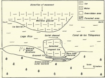
Fig. 9 Rough field sketch showing the terminus of the Moreno Glacier and the area recently overridden by it

Fig. 10 The area recently overridden by the Moreno Glacier. The block of stagnant ice, the inner hare moraine, the outer grass-covered moraine, and the forest, are shown from left to right (see text p. 44)
Two moraines immediately east of the stagnant block are as much as 4 m. high and have steep gable-shaped transverse cross-sections (Figs. 6, 9, and 10). The outer older moraine is covered with various grasses whereas the inner younger moraine is bare and barren. Dead trees are found both on and in the moraines. The older moraine is composed of both grey unweathered and yellow weathered material, whereas the younger moraine is composed of only grey unweathered material. The yellow material was probably derived from a weathering profile formed on land on older glacial deposits deposited in this area. The grey unweathered material probably came from beneath the weathering profile and from nearby unweathered lacustrine deposits. The continual deposition of lacustrine sediments, and the slow rate of sub-lacustrine weathering would probably result in deposits which would be mainly fresh and unweathered.Reference Kuenen 8 The presence of weathered material in the moraine proves that when it was formed the glacier was in a more advanced position than it had occupied for hundreds of years. At this point no older moraines nor any botanical evidence suggestive of a similar but earlier advance were noted. The inner moraine has small landslide scars and deposits on its flanks and along its base; along its summit there are many open cracks; the whole is composed of loose, unstable, chaotically deposited material which as yet has not had time to settle. The absence of morainal material on both the main glacier and stagnant block, the steep sides of the moraines, and the unstable loose material of which they are composed prove that they are push, not dump or lodge moraines. They were formed by four oscillations of the Moreno Glacier. The glacier advanced, formed the outer moraine by plowing up material in front of it, and then retreated to a position upstream from the inner moraine. A later advance formed the inner moraine and this in turn was followed by retreat. When the glacier advanced the second time no weathered material was available and the inner moraine is therefore composed only of unweathered material. The considerable difference in vegetation cover, stability and compactness of the two moraines makes it unlikely that the outer moraine was formed by the 1939–40 advance of the Moreno Glacier and the inner moraine by the 1941–42 advance. It seems more likely, especially in view of the very youthful appearance of the inner moraine, that it was formed by a still later advance, which took place perhaps only a few years ago.
Glacial grooves are found on a flat surface of till between the edge of the stagnant block and the inner moraine.Reference Ray 9 They cover an area several meters in length and width, are several centimeters deep and as much as 30 cm. wide, and terminate close to the inner moraine. They were formed by the irregular bottom of the glacier and by the same glacial oscillation that built the inner moraine. They are only a few years old as they have not been modified in any way and they indicate, therefore, that the inner moraine is also very youthful. The toe of the glacier which formed these moraines was not high enough to have dammed up the 1941–42 ice-dammed lake nor perhaps the 1939–40; 150 m. south in the area of the glaciated bedrock, however, the ice was high enough.
The Moreno Glacier has not been reaching its most advanced position for all areas at the same time. This is proved by the fact that it was pushing into a mature forest along its northern boundary in March 1949 whereas it reached its most advanced position in the overridden area perhaps ten years earlier.
Ameghino Glacier
The Ameghino Glacier, about 15 km. long and 2 km. wide, is 5 km. north of the Moreno Glacier, and terminates on land about![]() km. from Lago Argentino (Fig. 2). The Moreno and Ameghino Glaciers are fed from the same general snowfield. A few hundred meters downstream from the terminus of the Ameghino Glacier is a relatively high frontal moraine extending from one side of the valley to the other. It is bare and barren, composed of unweathered material, and obviously very youthful. An unweathered, bare and barren valley train extends from the moraine down to Lago Argentino. Deposited on a weathering profile, these outwash sands and gravels bury a forest which had been growing on the bottom of the valley. There is a well defined trimline on both sides of the valley about 150 m. above the edges of the glacier. Immediately above the trimline there is a mature forest; some immature trees grow below the trimline and above the glacier. After a study of these features the writers concluded that between 1870–80 the Ameghino Glacier reached a more advanced position than it had occupied in hundreds of years.Reference Nichols and Miller
10
At this time it formed the frontal moraine, the trimline, and the valley train, and since that time it has retreated several hundred meters to its present position. A hanging glacier in the Ameghino Valley and another a few miles to the north in the fjord of Cerro Mayo (Fig. 2) were studied by field glasses. The relation of glacial termini to a set of moraines and to similar trimlines indicates that these glaciers are also retreating and that they have behaved like the Ameghino. The Upsala Glacier, like the Moreno, terminates in a barrier in the north-western arm of Lago Argentino. One of the writers (M. M. M.), who later spent a short time in the vicinity of the Upsala Glacier in Brazo Norte and several others in the area immediately south of Lago Viedma, concluded that they, too, are retreating and behaving like the Ameghino.
km. from Lago Argentino (Fig. 2). The Moreno and Ameghino Glaciers are fed from the same general snowfield. A few hundred meters downstream from the terminus of the Ameghino Glacier is a relatively high frontal moraine extending from one side of the valley to the other. It is bare and barren, composed of unweathered material, and obviously very youthful. An unweathered, bare and barren valley train extends from the moraine down to Lago Argentino. Deposited on a weathering profile, these outwash sands and gravels bury a forest which had been growing on the bottom of the valley. There is a well defined trimline on both sides of the valley about 150 m. above the edges of the glacier. Immediately above the trimline there is a mature forest; some immature trees grow below the trimline and above the glacier. After a study of these features the writers concluded that between 1870–80 the Ameghino Glacier reached a more advanced position than it had occupied in hundreds of years.Reference Nichols and Miller
10
At this time it formed the frontal moraine, the trimline, and the valley train, and since that time it has retreated several hundred meters to its present position. A hanging glacier in the Ameghino Valley and another a few miles to the north in the fjord of Cerro Mayo (Fig. 2) were studied by field glasses. The relation of glacial termini to a set of moraines and to similar trimlines indicates that these glaciers are also retreating and that they have behaved like the Ameghino. The Upsala Glacier, like the Moreno, terminates in a barrier in the north-western arm of Lago Argentino. One of the writers (M. M. M.), who later spent a short time in the vicinity of the Upsala Glacier in Brazo Norte and several others in the area immediately south of Lago Viedma, concluded that they, too, are retreating and behaving like the Ameghino.
From preliminary field studies it appears that the glaciers on the east side of the Patagonian Andes are in general retreating and have been for the last seventy years or so, but that one glacier, the Moreno, is advancing and has been since at least the turn of the century. The writers have no answer as to why this is the case. Climatological and general geologic studies at both high and low elevation would be necessary to solve the problem.
Nearby Simultaneously Advancing and Retreating Glaciers
The Taku and Norris Glaciers are the Alaskan counterparts of the Moreno and Ameghino Glaciers in Patagonia. Both the Taku and Norris are fed from the Juneau Ice Field. Photographs taken by Cooper in 1916 and by Lawrence in 1949 show that the Norris has receded greatly since 1916 while the Taku has advanced.Reference Lawrence and Lawrence 11 Tarr and Martin, and Gilbert cite many other examples of nearby Alaskan Glaciers some of which were advancing and others retreating.Reference Tarr and Martin 12a , Reference Gilbert b
Many theories and mechanisms have been suggested to account for these phenomena. Some of these theories and mechanisms as well as additional ideas on the subject follow.
The principle of lag has general application in explaining glacier variations in either the same or opposite directions. Gilbert stated the principle as follows. “The chief cause of variation of the wasting end of the glacier is believed to reside in variation of snow accumulation on the névé fields, but considerable time is required for the transmission of the effect from end to end of the glacier … this time … varies with the length, slope, and other peculiarities of the individual ice streams, and the general result of its variation is that ice streams of the same mountain slope, or streams flowing from the same névé, initiate a period of advance or retreat in different years or even different decades.” Reference Gilbert 13
If accumulation in the snowfields of two adjacent retreating glaciers increases greatly and if the wave of advance of one reaches its terminus before that of the other there will be adjacent simultaneously advancing and retreating glaciers.
Climatic change has long been appealed to in explaining glacial variations.Reference Tarr and Martin 14 The variations of most glaciers, whether they are in the same or opposite directions, are undoubtedly due to climatic factors. They are generally thought to be a response to changes in snow accumulation in the glacier reservoirs. The net accumulation is a function of snowfall and wastage, and they in turn are controlled by temperature, insolation, wind direction, topography and other factors. The ultimate cause may be a fluctuation in solar radiation or a change in terrestrial factors; it may be local or widespread, and it may be long continued or temporary.Reference Lawrence 15 Unfortunately, in most areas where fluctuating glacial termini have been studied for some time reliable, long-continued climatic data are lacking.
Years ago Gilbert suggested that variations of certain Alaskan glaciers which were opposite in direction might be explained by a change in the temperature of the water in the Gulf of Alaska.Reference Gilbert 16 He reasoned that there is a temperature of water which is more favorable for the development of the glaciers in the coastal mountains as a whole than any other temperature and that either a lower or a higher temperature would in general result in smaller glaciers. When the ocean temperature is most favorable for the maximum development of the glaciers as a whole it will, however, be too warm for some glaciers and too cold for others because of local topographic conditions. A change in temperature in either direction therefore, would cause some glaciers to advance and others to retreat.
Lawrence has recently pointed out that the terminus of a glacier, the snowfields of which extend over a wide range of altitudes, would not for a time be greatly affected by a continuous rise of temperature. On the other hand, the terminus of a glacier which is fed by a snowfield that extends over a small range of altitudes would be sensitive to an increase of temperature and would soon retreat because of an increase of rainfall and a decrease of snowfall.Reference Lawrence 17 If two such glaciers are adjacent, both would ultimately retreat due to a continuous rise in temperature, but the latter would start to retreat earlier and for a time would continue to do so more rapidly. If, then, there was a continuous drop in temperature in the area, there would probably be an interval when one of the glaciers would be retreating while the other was advancing.
If the glaciers on the west coast of South America in the zone of prevailing westerlies and in the belt of Mediterranean climate to the north are all retreating and should the belt of prevailing westerlies move northward due to a general change in atmospheric circulation the glaciers in the Mediterranean climate might advance for a time while the glaciers to the south in the zone of prevailing westerlies would continue to retreat.
Tarr and Martin in their classic study of the Alaskan glaciers observed that the stagnant and retreating glaciers in the vicinity of Yakutat Bay started to advance rapidly after the 1899 earthquake in this area. They concluded that the advance resulted from the sudden avalanching by the earthquake of great quantities of snow and ice on to the glaciers and their snowfields.Reference Tarr and Martin 18 Glaciers in other parts of Alaska continued to retreat, and in the Yakutat area there were both advancing and retreating glaciers for a number of years after the earthquake as the wave of advance reached the ends of the various glaciers at different times.
Tarr and Martin also pointed out that the fall of unusual numbers of snow avalanches, due to meteorologic and topographic factors, might also cause small glaciers to advance while the majority of the glaciers of the area might be retreating. As examples of this mechanism they cited the advance of the Boveyre Glacier in Switzerland and the Stutfield Glacier in Canada. 19
In an area where glaciers are retreating, uplift as well as tilt might cause those glaciers affected by the movements to advance while those unaffected would continue to retreat. 20 Uplift might increase snowfall and decrease wastage because of the resulting lower temperatures. If these changes were of sufficient magnitude, they might cause retreating glaciers to advance. If the gradients of retreating glaciers were steepened sufficiently by tilt, they too, might advance for a time.
A high, large volcano might have on its flanks several advancing glaciers. If magma moves upward, or if volcanic activity is increased for any other reason, the geothermal gradient may be steepened more in some areas than in others. This differential steepening of the gradient may result in glacial retreat in some areas while the advancing regime may be maintained elsewhere. No examples of this mechanism are known to the writers, but it must have operated repeatedly, especially in volcanoes like Mt. Mazama, the ancestral cone of Crater Lake in Oregon, where glaciation and volcanic activity have alternated many times.Reference Atwood 21a , Reference Williams b , Reference Gregory and Wentworth c It has undoubtedly operated many times on volcanoes at high latitudes and altitudes, which are commonly above snow line, such as Erebus in Antarctica, as well as many cones in the high Andes. It was perhaps more common during the Pleistocene than at other times, for then there was a world-wide low snow line.
The differential deposition of volcanic ash can also produce advancing and retreating glaciers in the same area. If the layer of volcanic ash is above a certain critical thickness it will protect and insulate the snow and ice and thus favor glacial advance whereas if it is below this thickness it will actually increase wastage and thus favor glacial retreat. Because of the decrease in the thickness of ash with increasing distance from volcanoes glaciers close to volcanoes might, therefore, tend to advance due to this factor while those farther away would tend to retreat. If two near-by glaciers are retreating and one of them which is close to an active volcano is covered with a layer of ash above the critical thickness while the other which is more distant is covered with a layer below the critical thickness, the glacier close to the volcano may stop retreating and commence to advance while the other may continue to retreat but with greater rapidity. If two near-by glaciers are advancing and one of them is covered with a layer of ash below the critical thickness, while the other is not covered, the one covered may stop advancing and retreat while the other may continue to advance. Other combinations of glacial regime and differential deposition of ash could also result in near-by advancing and retreating glaciers. The ash which falls below the firn line, if not appreciably reworked, might be effective in melting the ice over a period of many seasons. The ash which falls above the firn line would be buried by the first winter’s snowfall, but it would probably be effective in melting the ice after it moved across the firn line and was thus brought to the surface by ablation, shear or tilt. Continued deposition over several seasons could increase the effectiveness of the mechanism.
In an area where glaciers are in general retreating, an advancing tide-water glacier may be present if a pro-glacial delta is being built in front of it. The growth of the delta would decrease wave action and submarine melting, both of which are important wastage factors. In this way the balance might be upset and the tide-water glacier might advance.
If a retreating tide-water glacier terminates in the upper end of a fjord where the water is as warm as that in the Gulf of Alaska, and if the melt water streams of a retreating glacier tributary to the fjord are building a delta into and across the fjord, the tide-water glacier may stop retreating and start to advance at about the time that the delta is built completely across the fjord. At this time the upper end of the fjord will be changed into a freshwater lake. When the lake has replaced the fjord, (1) wave attack at the barrier will be decreased, (2) melting of the barrier by water will be decreased as the lake will probably be filled with bergs, growlers and lake ice, (3) the free air temperature near the end of the glacier may be colder because of the presence of this ice. These factors all tend to decrease ice wastage and if they are of sufficient magnitude the former tide-water glacier may stop retreating and advance.Reference Tarr and Martin 22 There will then be a retreating tributary glacier and an advancing former tide-water glacier.
Should two adjacent glaciers and their snowfields be at different elevations, snow and ice may spill from the higher glacier to the lower across cols and thresholds. If a period of greater wastage and less accumulation ensues the glaciers will retreat, the general level of the snowfields and glaciers will drop, and a time may come when snow and ice can no longer spill over the thresholds. When this happens the retreat of the lower glacier will be accelerated. If, following this, there is a change in climate and accumulation increases and wastage decreases, the lower glacier may continue to retreat while the upper, after a period of time, will advance. A climatic change and the threshold mechanism may result, therefore, in nearby advancing and retreating glaciers.
Cirque recession may be more rapid at the head of one glacier than at another because of topography, wind direction, lithology, structure and other factors. If the cirques are adjacent glacial piracy takes place. If two adjacent glaciers are advancing and one is actively capturing the basin of the other there is a tendency for the active one to advance more rapidly and for the other apparently to retreat. The capturing process is, however, very slow and the differential terminal motion due to it would be so very small that it would undoubtedly be masked by the action of more important factors.
Snow and ice will move on a slope and become a glacier only if a minimum thickness is exceeded.Reference Matthes 23 If two near-by glaciers are retreating and one of them finally thins so that forward motion is no longer possible, it will become stagnant and its retreat will be accelerated. Should the climate now change so that accumulation increases and wastage decreases, the active glacier would start to advance after a period of time. The stagnant glacier, however, cannot advance until after it has been thickened beyond the minimum thickness for movement on its slope. For a time then, one glacier may be advancing and the other retreating.
It is concluded, therefore, that near-by simultaneously advancing and retreating glaciers may sometimes be explained as resulting from climatic factors, diastrophic movements, volcanic processes and topographic conditions.
Acknowledgements
Sincere appreciation is extended to Mr. Wm. O. Field, Jr., of the American Geographical Society who aided in the planning of the Patagonian expedition and who has also provided useful suggestions in the theoretical discussion. Grateful acknowledgement is also given to Dr. Agustin E. Riggi, Director-general of the Museo Argentino de Ciencias Naturales “Bernadino Rivadavia,” whose fine support made these studies possible. Special appreciation is also rendered to the following members of the museum staff: Dr. Mario E. Teruggi, Dr. Walter Sander, Mr. Luis M. Etchart and Mr. Felix Poran who were such pleasant and helpful field companions during the course of this work. Professor Charles F. Brooks, Harvard University and Mr. M. E. Willard, U.S. Geological Survey made many valuable suggestions.


