

Introduction
Measurements of Reference SommerfeldSommerfeld (1977) and Gubler (1977, 1979) indicate an inverse correlation between low-frequency noise originating from small displacements, settlements as well as limited fractures in the snow cover, and the natural stability of that snow cover in potential fracture zones of avalanches. Whereas Sommerfeld measures with seismometers fixed on the ground, highly sensitive accelerometers buried in the snow are used here. Measurements in potential avalanche-release zones show a good correlation between increasing noise and the beginning of natural avalanche activity. This type of stability indicator is incorporated into a remote station. From the simultaneous measurement of air temperature, global radiation, mean wind speed, wind direction, horizontal mass flux of wind-blown snow, snow depth, snow temperature profile, and the stability indices at different slope aspects, it is ultimately possible to get an improved insight into the mechanism which decreases or increases the natural stability of an inclined snow cover. These parameters, continuously recorded at the main slope aspects from the beginning of the snow accumulation supplemented by measurements of the surface temperature and the air humidity will be used in the future to model the snow stratification. A separate non-remote stability-recording system is used to investigate and improve the stability-recording system itself, particularly to determine the basic frequencies of the infrasonic acoustic emissions of the snow cover and of the signals originating from wind and gustiness.
This paper describes the recording and data-processing system and the evaluation of a first six months’ run.
Description of the Field Installation
The remote station is installed on the Gaudergrat, 2 300 m a.s.l., at a distance of about 3 km from the Institute on Weissfluhjoch. The Gaudergrat is a free-standing ridge with a height of 150 m relative to the surroundings. The main slope aspects are west-north-west and east-south-east with smaller slopes facing north and south. Typical slope angles are 30°-35°. Wind, snow-depth distributions, and snow-stratification profiles have already been recorded and analysed throughout several winters by Reference FöhnFöhn (1980).
A block diagram of the field installations is given in Figure 1. The system developed at the Institut für Schnee- und Lawinenforschung, Weissfluhjoch, using C-Mos technology, includes 32 three-digit data channels. The input data are stored in tristate buffers which are connected to the central unit by a three-digit data-parallel bus, a five-bit address bus, and a timing and an interrupt line. The channel electronics, three-digit counters, tristate interfaces, and analogue digital-converters are wired-in plug-ins. The channel number may be preselected on the plug-ins. This system enables the operator to change the system configuration during operation. Special plug-ins have been built to record wind, global radiation, and snow depth. The main filter—amplifier plug-ins for the measurements of stability index and the modem plug-in modulating the RF transmitter are wired in a special crate. The power supply system includes different voltage regulators for the internal logic levels (5 V), the internal analogue amplifiers (±5 V), reference voltages ( –6.8 V, 5 V) and ±12 V for external transducer electronics. The power requirements of the whole station are ±12 V, 0.5 W. The power is delivered by four 36 A h buffer batteries in combination with two 8 W peak solar panels. The data are transmitted to the Institut bit serial by a one-way FM radio link. The maximum period between successive data transfers has to be pre-set at the central unit (30 min to 240 min in intervals of 30 min). The data transfer and the timing is controlled by an internal quartz clock. Each channel may cause an interrupt which reduces the period between successive data transfers to 30 min. In most applications this interrupt is caused by a channel overflow.

Fig. 1. Block diagram of the remote station.
Stability Recording
High-sensitivity piezoelectric transducers from Brüel and Kjaer (Schweiz) A.G. are used as acceleration sensors. These laboratory-type transducers of the Delta Shear design have a sensitivity of 15 pC m—1 s2, a good temperature stability, and are very light. We embedded the stainless-steel transducers in foam cylinders (length 0.25 m, diameter 0.05 m, weight 110 g) to match their mean densities to the density of settled snow (200kg m—3). This matching is important to get an optimal signal transfer from the snow to the transducers. The acoustic wave propagation velocities do not have to be matched because the wavelengths of the infrasonic signals are large compared with the transducer dimensions. The charge signals from the transducers are converted to voltage signals using charge amplifiers/line drivers with a conversion factor of 0.5 V/pC and a band width of 0.5 Hz-10 kHz. Cable lengths up to 250 m are used between the converters and the main filter-amplifiers. The filter-amplifiers consist of third-order high-pass Chebyshev filters (60 dB/decade), second-order low-pass Butterworth filters (40 dB/dccade) and level discriminators. The in-band voltage amplification is 300. The discriminator level may be varied from 0 V to 5 V. The variable filter cut-off frequencies are 2, 5, 20 Hz (high pass) and 50, 100, 1000 Hz (low pass). The discriminator output operates a single-shot multivibrator. The dead time of the system is fixed at 2 - 10–2 s. The output pulses are accumulated in counters. Best results were obtained in the frequency band 5-50 Hz, with a discriminator level corresponding to 10–3 m s–2 (at 33 Hz 5 -10–6 m s–1, 2.5- 10–8 m).
Snow Depth
The snow depth is determined by measuring the time of flight of an ultrasonic wave packet emitted from a sonic transmitter above the snow surface and reflected from the snow surface back to the receiver/transmitter system. The light-weight transducer system is battery powered and is fixed to a post above the snow surface. Data and commands are transmitted by a two-wire cable to the data acquisition device. This development of the Institut für Schnee- und Lawinenforschung, Weissfluhjoch/Davos, is described elsewhere (Reference GublerGubler, 1981 [b]).
Temperature Profile
Sixteen temperature sensors (National Semi-conductor LX 5600 H) are mounted at fixed separations of 0.2 m to a post. The lowest sensor is buried in the ground. The area of the contact surface between the sensor and the snow, a thin white-coloured vertical brass plate, is 10–3 m2. The thermal insulation to the post consists of several millimetres of plastic. Each time data transfer to the Institut takes place, the temperatures of four equispaced (0.8 m) sensors are measured and transmitted. It takes four transmission sequences to record a complete profile. This design reduces the necessary number of channels from sixteen to four. The absolute accuracy amounts ±0.3 deg.
Metering Blowing Snow
A photoelectric sensor (Reference GublerGubler, 1981 [a]) is mounted below a wind roof. This concept was selected for its ability to perform measurements of the horizontal mass flux over a crest at constant height above the surface independent of the actual snow depth. The output pulse- rate of the system is proportional to the mean mass flux [kg m–2 s–1]. Drift particles larger than 50 μm in diameter are classified according to their volumes in five classes. The accuracy (±30‰) of the flux meter is mainly limited by physical constraints.
Global Radiation
Global radiation is measured continuously with a pyranometer. The integration over a recording period is performed using an analogue frequency converter and a scaler. The sensor mounted about 4 m above ground on the crest. Unfortunately, covering of the sensor with snow during short windless precipitation periods cannot be avoided.
Air Temperature
The free-air temperature is recorded every time data transfer takes place.
Wind
The mean wind velocity is measured with a cup anemometer. The output of the alternator is connected to a counter input. The Vane of the anemometer is mechanically coupled to a potentiometer. To be able to record the mean wind direction for the sampling period the instantaneous direction of the vane is periodically recorded with a resolution of 90° The result of the Position determination is Stored in four two-digit counters corresponding to four 90° sectors.
Receiving Station: Data Processing
The output signal from the FM refiver iS decoded by the modem receiver and stored in a sift register. From this shift register the data may be read out at any time after a transmission sequence has been completed. The on-line data processing immediately following each datatransmission is described in the flow chart (fig.2.). The units the decoded data are given in table 1.

Fig. 2. Flow chart of the data processing.
Table I. Measured Quantities and Their Units

Besides the quantities given in Table 1, two channels are used to transmit control voltages. All these data are available at any time except when a data transmission is taking place.
Besides the necessary programs, 340 data sets (32 channels) may be stored on one magnetic data cartridge. Experience showed that this storage capacity corresponds to about one month of data accumulation. When a cassette is completed, the data are transferred off-line through an interface cable to a HP 9821 desk calculator and re-stored on Philips cassettes. The off-line data processing is done with the HP 9821 desk calculator. The HP 9821 data evaluation programs are listed in Table II
Results
The Gaudergrat station has been operating for two winters. During the winter 1977-78 the instrumentation was tested but the on-line data processing was not yet in operation. The whole system as described in the earlier sections, was operated for the first time from the beginning of November 1978 until the end of April 1979, a period of about 180 d. Some investigations were performed in parallel with the older measurement system which was already in use during the winter 1976-77 (Reference GublerGubler, 1977, 1979).
Table II. Programs Used to Process Data on a HP 9821 Calculator

Temperature Profile
Figure 3 shows the development of the temperature gradient in the snow in November and January. The large gradients in November near the ground caused a layer of about 0.40 m of depth hoar. Air temperature varied around 0°C but the global radiation shows that we had clear sky and, because of this, very low snow surface temperatures at the location of measurement (which had a westerly aspect) for a large part of the month. The corresponding plots of temperature profiles show that the temperatures near the surface were as low as –12°C. The development of the temperature gradient in January demonstrates very clearly the influences of air temperature and total snow depth on the distribution of gradient in the snow cover.

Fig. 3. Development of the temperature gradient in the snow in November and January as a function of air temperature, snow depth, and global radiation.

Fig. 4. Snow transport over a mountain crest recorded at a height of 0.5 m above ground. The histogram includes the data of a three-month run (85d). The wind paths and the corresponding times are given in the histogram.
Wind and Drifting Snow
The wind and snow-drift data have been analysed for the months of February, March, and April for a period of 85 d. The results for the whole period are shown in Figures 4 and 5. Typical drift periods are given in Figure 6. On the Gaudergrat, precipitation in most cases comes from the north sector. The three figures indicate that precipitation-induced fluxes at low wind-speeds are significantly higher than fluxes at corresponding low wind-speeds without precipitation. Figure 5 shows the strong dependence of the mass flux on the wind-speed for constant snow-surface and meteorological conditions, but the correspondingly very small dependences for the integral representations (Figs 3 and 4) indicate that there exists an even stronger dependence on the latter parameters. The determination of the total mass flux over an alpine ridge is discussed by Reference FöhnFöhn (1980).

Fig. 5. Mean horizontal mass jlux over a mountain crest. Same data as in Figure 6. The integral fluxes and the corresponding times are given in the plot
Stability
Preliminary investigations of the frequency spectra of the acceleration signals emitted by the snow cover indicate that the basic frequencies of the signals originating from displacements, settlements, and limited fractures are in the range of 30-40 Hz, whereas the signals from gusts have basic frequencies below 5 Hz. Constant strong winds induce signals in the kilohertz range. For these reasons we chose our sensitive frequency band between 5 Hz and 50 Hz.
Unfortunately besides the gustiness there are many other sources of erroneous increased event rates: aircraft (only in good weather conditions), tourists, artillery, and maintenance of the instrumentation. In Figure 7 the event rates higher than the background event rate increased by one standard deviation are plotted. Many of the events can easily be assigned to known distortions.

Fig. 6. The traces show the horizontal mass flux over an alpine ridge together with mean wind-speed, wind direction, and total snow depth as a function of time.
In three cases small avalanches in the fracture zones under investigation were observed and were clearly announced by the system. In a few other cases, artificially or naturally released avalanches were observed in the Parsenn ski area but not on the Gaudergrat. In most of these cases the event rates in slopes with the appropriate aspect increased too. In some cases it could be observed that the event rate increased only for some hours, disappeared, and increased again the next day under similar conditions (Fig. 8). This indicates that, even during high winter conditions, global radiation affects natural stability at least in steep avalanche-release zones. The seismometer installed was not sensitive enough to record the small avalanches which occurred during winter 1978-79 at Gaudergrat.
Eight periods of instabilities were clearly sited during winter 1976-77 at two different locations during a total recording period of 50 d. Those results are discussed in some detail in Reference GublerGubler (1977). To get further improved results, more experience is needed to find the most sensitive and representative positions for the transducers.

Fig. 7. Histogram showing the periods of event rates higher than the background rate for five transducer locations.
Conclusions
The remote system described allows for an investigation of the dependence of natural stability variations in avalanche-release zones on snow-cover and meteorological parameters. To be able to formulate representative quantitative results many more records of unstable situations are necessary. Sensors for snow temperature and snow depth have to be installed in slopes with north-western as well as south-eastern exposure.
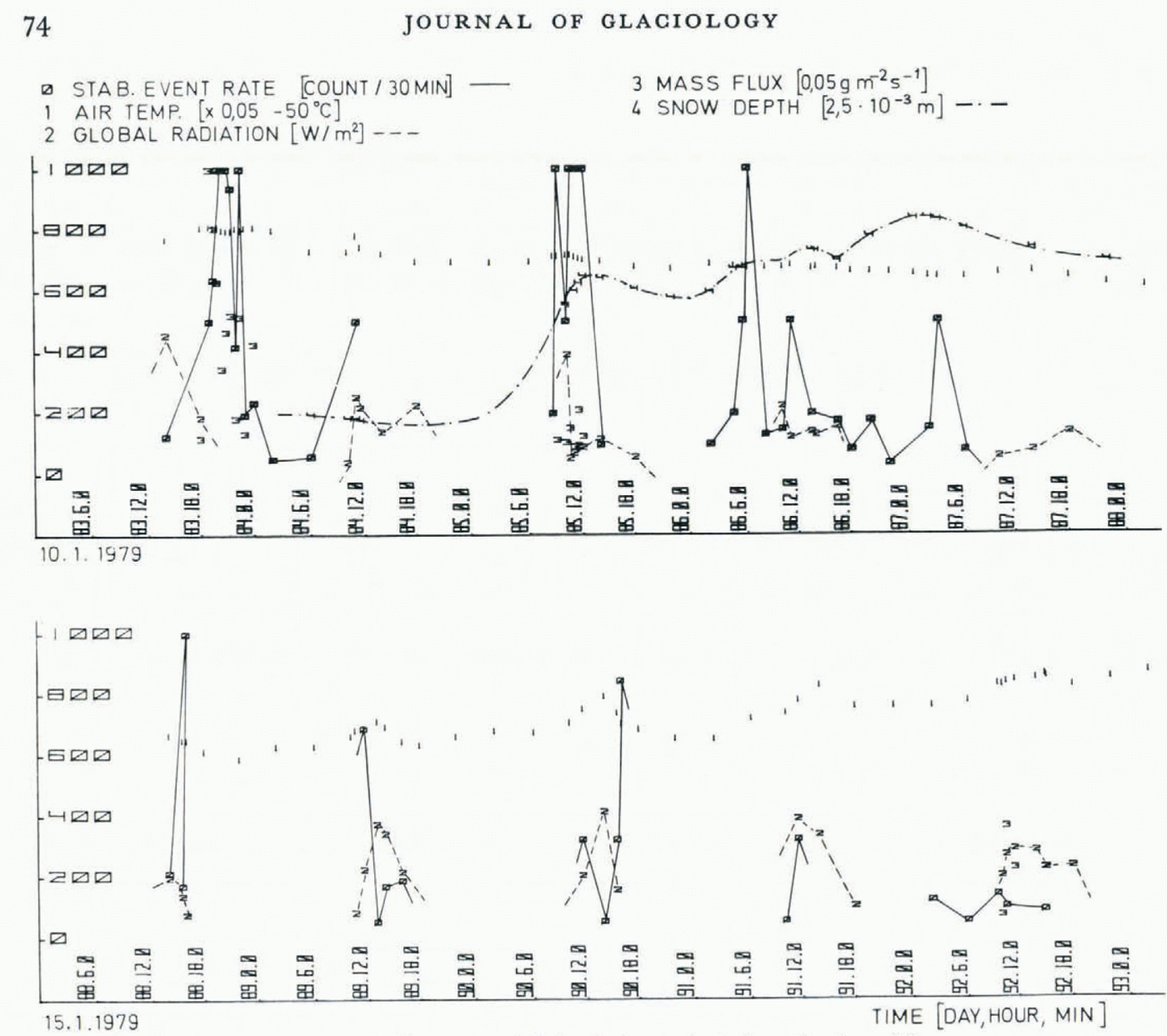
Fig. 8. Event rate, global radiation, and wind as afunction of time.
Acknowledgement
I am indebted to G. Klausegger and A. Borner for preparing the instrumentation.


