1. INTRODUCTION
The Imperial Transantarctic Expedition under the leadership of Sir Ernest Shackleton sought to make the first crossing of the Antarctic continent from the Weddell Sea to the Ross Sea. While this goal was not achieved, and the expedition suffered many tribulations, including the loss of their vessel, the Steam Yacht (SY) Endurance, what unfolded was one of the great sagas of polar exploration of the Twentieth Century. All of the 28 expedition members survived their ordeal due, in no small part, to Shackleton's leadership and ship's master, Captain Frank Worsley's superlative skills as a navigator under the most difficult of conditions. At the present time the wreck of Endurance lies undiscovered at the bottom of the Weddell Sea.
Upon departing South Georgia on 5 December 1914, Endurance became entrapped in sea ice on 18 January 1915, was abandoned on 27 October and finally sank on 21 November. In his log Worsley (Reference Worsley1916. P.45) writes
At this location the ocean depth is approximately 3,000 m. The purpose of this paper is to examine how this fix was made by consulting the entries in Worsley's original log and workbook (Worsley, Reference Worsley1916) and other sources and to describe the uncertainties to which it may be subject.
The stated position appears in the log with a single underline to distinguish it from fixes that were obtained by means of celestial navigation which are double underlined. Taken at face value, the position might be interpreted as having an error of ± 15′′ or ±0·25 nautical miles (NM) in latitude and ± 15′′ (±0·1NM) in longitude. However a number of factors suggest that the uncertainties are considerably larger than this. A number of these are
• The sinking occurred during a period in which no celestial sights could be taken and the speed and direction of the ice drift was not well known.
• There are possible arithmetic errors in the reduction of the noon sights of 18 and 22 November that bracket the sinking.
• The ship's chronometers were last rated by lunar occultation on 15 September, and would have accumulated an inevitable drift that induces a significant error in longitude.
Of course, the Captain's in situ assessment of the circumstances, his experience and intuition must count for a great deal in favour of the stated position and may incorporate information not recorded in the log.
Accurate positions are now known for places that were used in subsequent ratings of the chronometer and, while this does not pinpoint the wreck itself, it does serve as an indication of the magnitude, and possibly the sign, of the uncertainties that should be expected. This would help inform possible searches as to the location and size of the area that would need to be swept in order to have a reasonable chance of finding the wreck of Endurance.
The full source data from the log books, on which the authors base their conclusions, is given in this paper. It is understood that others may choose to interpret this content differently or that new information may eventually come to light.
2. NAVIGATION ON THE ICE FLOE
Position finding on the ice employed the methods of celestial navigation that were standard in the early part of the twentieth century and have been described in detail elsewhere (Bergman et al., Reference Bergman, Huxtable, Morris and Stuart2018; Bergman and Stuart, Reference Bergman and Stuart2018). From Ocean Camp, established on the Weddell Sea ice close to Endurance, noon sights of the Sun were made to determine latitude and AM and PM time sights were taken for longitude, ideally when the Sun stood well off the meridian. The latter provides a measure of the observer's local time. Its difference from Greenwich Mean Time (GMT), as determined from the chronometer, yields the longitude.
The reduction of a time sight to obtain longitude, λ, requires entering an assumed latitude, L, into the calculations with:
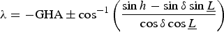 $$\lambda = -\hbox{GHA} \pm \cos ^{-1} \left({\sin h -\sin \delta \sin \underline{L} \over \cos \delta \cos \underline{L}} \right)$$
where h is the Sun's true altitude, GHA is its Greenwich Hour Angle and δ its declination. The upper (lower) sign applies for PM (AM) time sights. When the Sun is on the prime vertical, i.e. due east or west, the longitude obtained is independent of this assumed latitude but not at other azimuths. However, such observations can be difficult and less accurate due to the low elevation of the sun at those times.
The noon sight provides an unambiguous measure of the observer's latitude at the time of the Sun's meridian passage:
 $$L=90^{\circ} -h + \delta$$
For a vessel making way, the course and distance travelled would be carefully recorded and the assumed latitude required in the AM sight reduction would be computed from the noon latitude by means of Dead Reckoning (DR). The longitude thus obtained would be advanced by DR to obtain the noon position that was then entered in the log. A similar procedure would be followed for the PM time sight. From Ocean Camp and drifting with the ice there is no independent way of reckoning the course and distance travelled meaning that a key ingredient of the standard reduction procedure is missing.
From measurements taken earlier aboard Endurance, expedition physicist Reginald James concluded (Shackleton, Reference Shackleton1920. Appendix I):
“The rate and direction of drift appeared to depend almost entirely on the wind–velocity and direction at the time”.
Shackleton (Reference Shackleton1920, Ch. V. P.95) writes:
“The ice was not moving fast enough to be noticeable. In fact, the only way in which we could prove that we were moving at all was by noting the change of relative positions of the bergs around us, and, more definitely, by fixing our absolute latitude and longitude by observations of the sun. Otherwise, as far as the actual visible drift was concerned, we might have been on dry land”.
At drift speeds of under half a knot, adjustments could be made to the standard procedures but still yielded noon positions of an accuracy that is entirely adequate for the purposes of eventually making landfall. The longitude recorded for the noon position was the average from AM and PM time sights or sometimes estimated when one of these could not be made, “Allowg 45′′W for P.M Sights” (Worsley, Reference Worsley1916. P.49).
Measurements of the Sun's altitude were undertaken by theodolite or sextant. The theodolite is preferred as it is supported on a tripod and not hand held as is the sextant. The latter does not need a separate procedure for levelling but suffers from problems of identifying the visible horizon which may appear displaced by anomalous refraction, especially at the low temperatures of the polar regions. The log entry for the PM time sight of 26 November (Worsley, Reference Worsley1916. P.47) records longitude
“52°15′ Sextant
52°17′45′′ by Theodolite 1/2 hour later”
representing a difference of about 1 NM.
In a few cases, for example 7 November (Worsley, Reference Worsley1916. P.41), the theodolite readings are given to the nearest arc second and the altitude was “Cord for levels” but generally altitudes are recorded to the nearest 1/2 arc minute and the instrument used is not always specified.
3. CIRCUMSTANCES OF THE SINKING
The Expedition's positions as given in the log for October and November 1915 are plotted in Figure 1. The Expedition remained aboard Endurance drifting with the sea ice but on 24 October their situation deteriorated when the “Ship sustained heavy pressure thru having got pushed into a bad angle of floes & pressure ridges” (Worsley, Reference Worsley1916. P.36). Despite the best efforts of the carpenter and crew, on 27 October she had to be abandoned and the “Men & dogs sleep on floe.” (Worsley, Reference Worsley1916. P.38). Up until 27 October positions plotted in Figure 1 reflect those of the Endurance herself and, subsequently, the position of Ocean Camp nearby.
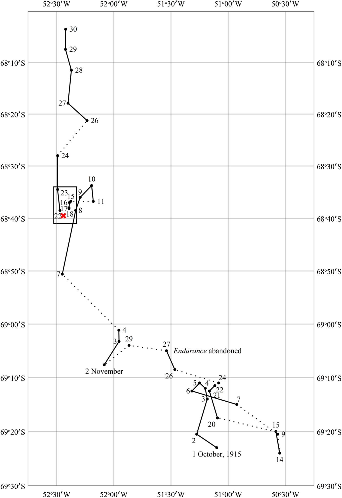
Figure 1. Expedition noon positions recorded in Captain Frank Worsley's log book. Consecutive daily sights are connected by a solid line. The rectangle at the left indicates the region covered in Figure 3. The position given in the log for where Endurance sank is indicated by an ‘X’.
The distance from Ocean Camp to Endurance is recorded as being “about one and a half [statute] miles from the wreck” (Shackleton, Reference Shackleton1920. Ch.V, P.87) and, in connection with the sinking, it is also stated as being “a mile and a half away” (Shackleton, Reference Shackleton1920. Ch.V, P.99). The bearing between the two has not been found although Shackleton (Reference Shackleton1920. Ch.IV, P.84) writes that on the first day's march “by 5 p.m. had covered a mile in a north-north-westerly direction”. Subsequently Ocean Camp was established on a more stable part of the floe nearby.
Figures 1 and 3 plot the noon positions for October and November 1915 as black dots as they are given in the log. Daily observations are connected by a solid line when consecutive. The rectangle at the upper left in Figure 1 indicates the area covered by Figure 3 and “X” shows the location that Worsley gives for the sinking.
The track in Figure 1 shows a general meander in October with a steady northward drift being established in November. This flow slows and reverses on 10 November with little or no change at least until 18 November. This northerly drift is then re-established by around 22 November. The sinking occurred towards the end of a three day period in which no navigational sights could be taken and the extent of the southward drift, if it continued, is therefore largely unknown.
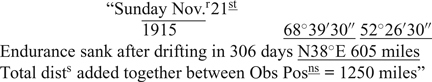
On 21 November, 1915 Shackleton (Reference Shackleton1915) records “at 5pm she went down by the head.”
4. CAPTAIN WORSLEY'S ESTIMATE
The observation made prior to the sinking was a PM time sight on 18 November taken at 7h40m23s GMTFootnote 1 or approximately 16h10m local mean time. No further observations could be made until the AM time sight on 22 November at 0h21m28s GMT or 8h50m local time. In the intervening three-day period there is no information available to constrain the position which would thus be subject to a relatively large uncertainty.
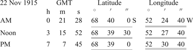
The observations of 22 November 1915 as they appear in the log (Worsley, Reference Worsley1916. P.47) are summarised below:
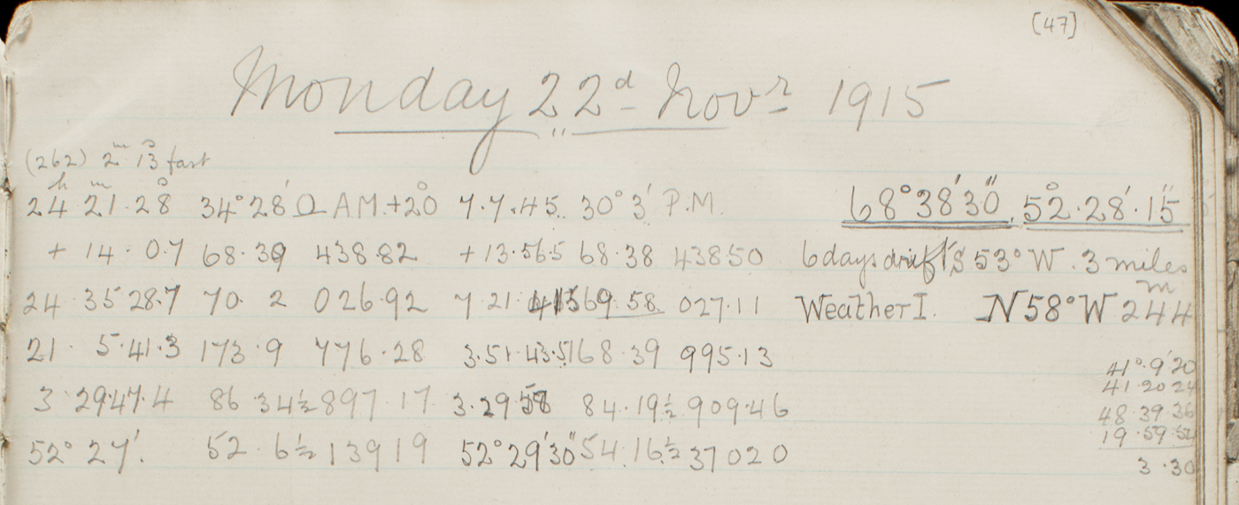
Figure 2. Log book entry for 22 November 1915 showing AM and PM time sights and the noon sight reduction at lower right. (Canterbury Museum, with permission).
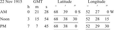
GMT given here for the noon sight has been inferred from the longitude and interpolating values for the Equation of Time tabulated in the Nautical Almanac (1915. P.123). For the reduction of the time sights the noon latitude has been by adjusted by ± 30′′ which is consistent with an assumed northerly drift speed of about 0·15 knot. Although the time interval between noon and AM and PM time sights is unequal (2·9 vs 3·9 hours) the relative insensitivity of the reduction procedure to latitude and the smallness of the assumed change makes this justifiable. The recorded noon longitude is then the average of longitudes obtained from the time sights. The difference in longitude obtained from the AM and PM time sights amounts to 0·9 NM.
Although not known for certain, it appears that to fix the location of the sinking of Endurance, lacking any concrete information as to the intervening drift, Worsley simply applied an offset amounting to 1·2 NM at a bearing of S33°E to the closest reliable position available to him.
The recorded sights and their reductions as they appear in the log for 22 November (Worsley, Reference Worsley1916. P.47) are shown in Figure 2. The numbers are all crisp, clear and unambiguous. Those related to the noon sight have been reproduced and labelled below:
A correction of 11′4′′ is applied to the observed altitude of the Sun's lower limb to account for the Sun's semidiameter, dip of the horizonFootnote 2, refraction and parallax. The presence of a dip correction indicates that the sight was taken using a sextant. The Sun's declination is correctly interpolated from values tabulated daily in the Nautical Almanac.
The latitude obtained by adding the last two lines is 68°39′ 30′′S but is not written out in full. Instead it appears that a few of the relevant digits were jotted down before the final result was incorrectly recorded as 68°38′ 30′′S. This is 1 NM north of the correct position.
Another arithmetic error appears to have been made in the noon sight of 18 November but is of little consequence when it comes to locating the wreck. In general, arithmetic errors are very rare in the log and it is particularly unfortunate that there are two on the dates that bracket the sinking.
5. LOCATION OF THE WRECK OF ENDURANCE
In Figure 3 the black dots, labelled with their dates, plot the Expedition's positions exactly as recorded in the log from 15 to 23 November and are given in Table A1 in the Appendix. Lines connecting positions on consecutive days are drawn.
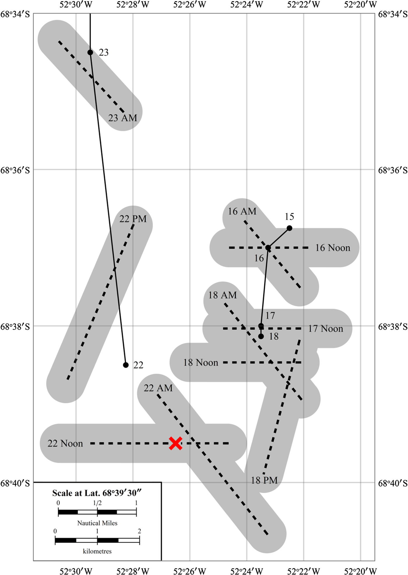
Figure 3. Positions of Ocean Camp as recorded in the log. The dashed lines are lines of position computed from intermediate values recorded in the log and are surrounded by an assumed error band of±1/4 NM indicated by the grey shading. The position given in the log for where Endurance sank is indicated by an ‘X’.
Each celestial sight generates a Line of Position (LoP) along which the observer's location could lie. LoP's are the cornerstone of modern celestial navigation but in 1915 this approach to position finding was still considered as the “new navigation”.
LoP's have been computed from altitudes and intermediate results recorded in the log. These are plotted as dashed lines and should be understood as being surrounded by a band of uncertainty of at least ±1/4 NM perpendicular to their direction as indicated by grey shading. The LoP's are shown without any rounding having been applied, unlike the positions recorded in the log that are sensibly rounded. For this reason the LoP from the noon sight of 17 November does not pass exactly through the noon position given for that date. The source of the discrepancies between noon positions on 18 and 22 November and their LoP's is described in Section 4. The information extracted from the log and needed to produce the LoP's is summarised Tables A1 and A3 in the Appendix.
The unfortunate but inescapable fact is that no navigational sights could be made for a period of three days prior to the sinking and the first sight following it, the AM time sight of 22 November, was only obtained nearly 16 hours later. The noon sight, on which Worsley likely based his estimate of the position, was made some 19 hours after the event.
5.1. Latitude
If the procedure described in Section 4 that Worsley used to obtain the noon position for 22 November is repeated, but taking the observed latitude to be 68°39′ 30′′S the result is:
and applying the same offset as Worsley did would place the wreck at 68°40′ 30′′S 52°25′ 45′′W. The difference in longitude obtained from the AM and PM time sights amounts to 2·2 NM, compared with the log's 0·9 NM. This value is a consequence of assuming a low northerly drift speed and is large enough that it may have caused Worsley to re-examine his assumptions.
This latitude 68°40′ 30′′S represents the northern limit for the area in which the wreck could lie and is conservative since it does not incorporate an estimate of the drift in the 19 hours since the sinking.
Examining the points of intersection of the LoP's with the overall northerly track, it is found that the drift north advances at a fairly constant rate between the 22 and 24 November noon sights averaging just under 1/4 knot.
In South, Shackleton (Reference Shackleton1920. Ch. V, P.98) writes:
“A wretched day with rainy sleet set in on November 21, but one could put up with the discomfort as the wind was now from the south.
The wind veered later to the west, and the sun came out at 9 p.m. For at this time, near the end of November, we had the midnight sun. ‘A thrice-blessed southerly wind’ soon arrived to cheer us all”.
and on that date his diary entry (Shackleton, Reference Shackleton1915) records, “With a SSE fair wind all day the temp has been up to +37 & +35 most of the day”.
Despite some apparent variability in the wind's east-west component there can be little doubt that a southerly wind was blowing throughout 21 November and it might be expected that a northerly drift was already well established at the time that the sinking took place. Indeed acceleration of the ice sheet to the north may have caused the floes to separate and precipitated the sinking.
If it is assumed that the wind and northerly drift speed of the ice remained relatively constant from 21 to 24 November, then the change in latitude between the noon sights of 22 and 24 November can be projected back to the time of the sinking at 5pm on 21 November. Allowing an additional 1 NM to account for the distance from Ocean Camp gives 68°45′S as a southern limit for the area in which the wreck might be found. The LoP from the 22 November AM time sight is suggestive of a north-westerly drift turning north in the course of the morning.
5.2. Chronometers and the uncertainty in longitude
A great deal of care is required in maintaining the chronometers and determining their errors and rates and weighty treatises have been written on the subject (Shadwell, Reference Shadwell1861). Temperature variations are a major contributor to changes in the chronometer rate and an effort would be made minimise these.
The primary chronometer used in conjunction with time sights for longitude and later for occultations was the Mercer, serial number 5229, often denoted in the log as “Chron X”. This is a boxed chronometer now in the collection of the National Maritime Museum, Greenwich, UK (http://collections.rmg.co.uk/collections/objects/79134.html). It makes its last appearance in the log on 27 October. When the Endurance was abandoned it was no longer possible to keep it in a temperature-controlled environment. From 2 NovemberFootnote 3 it was replaced by a Smith chronometer, serial number 192/262, now at the Scott Polar Research Institute, Cambridge, UK (http://www.spri.cam.ac.uk/archives/shackleton/articles/N:_999a.html). This takes the form of a large pocket watch and, although not designed with this in mind, it could be worn close to the body to maintain it at a constant temperature. Worsley (Reference Worsley1998. P.191) mentions that “I carried… the chronometer…slung around my neck by lampwick, inside my sweater, to keep it warm”. This chronometer was the one ultimately used to navigate the James Caird on the famous 800 mile crossing from Elephant Island to South Georgia although it is believed that the Mercer accompanied them as well. Worsley (Reference Worsley1998, P.101) on their arrival at Elephant Island in April 1916 writes of it:
“This English chronometer, an excellent one of Smith's, was the sole survivor, in good going order, of the twenty-four with which we set out in the Endurance.”
As evidenced by tables of daily comparisons (Worsley, Reference Worsley1916. P.1-3) similar chronometers were placed under the thermal stewardship of Hudson (192/232) and Wild (192/231).
On 3 November the Smith 192/262 is recorded as having a Chronometer Error (CE) of “slow 40m30s” and “fast 3m28 · 5s Cor” on 7 November indicating that it had been reset. The exact procedures being followed here are uncertain but it may be assumed that Worsley followed best practices under the circumstances in making the adjustments.
Initially, a Chronometer Rate (CR) of losing four seconds per day was used, around the beginning of February 1916 this was adjusted to losing five seconds per day. Again the exact method by which the new CR was determined is unknown but it is likely that it involved comparison with some sort of ensemble average of the chronometers that were deemed to be relatively reliable.
Upon rating, the uncertainty in GMT as obtained from the chronometer is zero for practical purposes but it naturally grows over time, and with it the uncertainty in longitude.
The precise error in longitude due to chronometer uncertainty at the time of the sinking of Endurance cannot be definitively extracted from the entries in the log book. The transition from one working chronometer to another adds to the difficulty of reliably pinning down the uncertainty in the CE. The best that can be done is to provide an estimate of the typical magnitude of the uncertainty that could be expected after a specified time has elapsed since the last rating.
The Expedition rated their chronometers in Buenos Aires on 24 October 1914, however, while out of sight of landmarks with accurately known longitudes, the uncertainty in the chronometer time grows and this cannot be remedied by methods that are typically familiar to mariners. From 24 June to 15 September 1915, when increasing daylight rendered further observations impossible, a series of timings of occultations (Bergman and Stuart, Reference Bergman and Stuart2018) were made as a way of absolutely obtaining GMT and thereby rate the chronometers. The upshot of the observations of 24 June was that the working chronometer, the Mercer 5229, had its CE adjusted from fast 6m24s to fast 2m1 · 8s.
There were 243 days that elapsed between the rating of the chronometers in Buenos Aires and the first observed occultation and in that time, the Mercer 5229 chronometer had drifted by 4m22s from its expected value. Assuming linear growth, the 67 days from the last occultation to the sinking of Endurance would imply an estimated uncertainty of 18′ or 7 NM in longitude.
From Patience Camp on the Weddell Sea pack ice, an attempt was made to rate the chronometers by triangulation on Mount Percy on Joinville Island from 24 to 27 March 1916 (Bergman et al., Reference Bergman, Huxtable, Morris and Stuart2018; Bergman and Stuart, Reference Bergman and Stuart2018). However doubts about the identification of Mount Percy, the accuracy to which its true position was known, the large distances and small angles made Worsley leave the CE unchanged. These observations concluded that Mount Percy lay 10 NM or 23′ of longitude west of where the Smith chronometer would place it. The modern longitude for Mount Percy is 55°49′W which is 11′ further west of the position as known to Worsley and implies a CE 2m16s slower than expected.
On 24 April 1916 immediately prior to departure from Elephant Island for South Georgia, Worsley was able to take a time sight from Cape Wild (now Point Wild). A detailed analysis can be found in Bergman et al. (Reference Bergman, Huxtable, Morris and Stuart2018). The location from which the sight was made is narrowly constrained by the geography and using the modern coordinates 61°6′S 54°51′30′′W the chronometer error is found to be 2m25s slower than expected.
There were 155 days that elapsed between the last observed occultation and time sight on Elephant Island. By that time the Smith chronometer had drifted by 2m25s from its expected value which under the assumptions above implies an uncertainty of 16′ or 6 NM in longitude.
In general, Worsley appears to display a tendency to underestimate the CR for the Smith. In February 1916 the CR is revised to losing 5s per day from its initial value of 4s. The Elephant Island time sight on 24 April, 1916 shows it to be 2m1s slower than expected but he chooses to only “allow” 1m4s citing that his longitude is “only approximately known” (Worsley, Reference Worsley1916. P.93). This builds in a safety margin against overshooting South Georgia to the east. However on approach to South Georgia he was about 20 NM astern of where observation showed. Roughly half of this is due to the adjustment applied on Elephant Island and the rest is attributed to the chronometer “being much slower than I had allowed” (Worsley, Reference Worsley1916. P.101). Underestimating how slow the chronometer is running places the true position to the west of that obtained by celestial fix.
6. CONCLUSIONS
The methods used by Captain Frank Worsley to estimate the position of the sinking of the vessel, Endurance, have been examined through entries in the original log book. It is pointed out that the sinking occurred in a three day period in which no navigational sights could be made and the drift of the ice is unknown. After correction of an arithmetic error in the reduction of the noon sight of 22 November 1915 it is concluded that the wreck likely lies somewhere in a band of latitude 4·5 NM wide from 68°45′S to 68°40′30′′S but not as far north as Worsley placed it. The inevitable growth of the uncertainty in the chronometer time since rating means that the longitude is not known to an accuracy of better than about 16′ or 6 NM. A tendency to underestimate slowness of the working chronometer would favour a search area to the west which might be reduced by a westward component of the ice drift between the sinking and the first celestial sights.
ACKNOWLEDGEMENTS
The authors wish to thank the Canterbury Museum for providing access to Captain Frank Worsley's log books.
APPENDIX
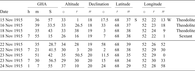
This appendix collects the log entries used in the construction of Figure 3. Table A1 gives the noon positions as recorded in the log book from 15 to 24 November. Double underlining indicates observed positions. A single underline is used to denote an estimated position of which the recorded longitude of 17 November is the only example.
Table A1. Noon positions as given in the log book
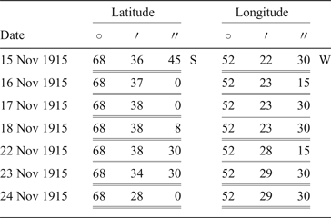
Table A2 lists the true altitude of the Sun's centre and its declination as recorded in the log and used in the reduction of noon sights. The latitude in the right-hand column is computed directly from these values using Equation (2). Note that the latitudes for 18 and 22 November differ significantly from those given in the log due to apparent arithmetic errors.
Table A2. Noon sight observations and Nautical Almanac data as given in the logbook. The values in the right hand column are calculated from those to the left by means of Equation (2).
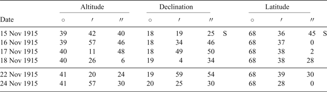
Table A3 gives the Greenwich Hour Angle in time, true altitude and declination of the Sun extracted from the log for the reduction of time sights. Note that in practice the log records the south polar distance (=90° + declination) as this quantity is entered in an equivalent form of Equation (1) rearranged to facilitate evaluation using logarithm tables (Bergman et al., 2018). The Latitude column gives the assumed value for the purposes of calculating the Longitude in the right hand column by means of Equation (1).
Table A3. Time sight observations and Nautical Almanac data as given in the logbook. The values in the right hand column are calculated from those to the left by means of Equation (1).