


1. Introduction
The situation of getting lost is commonly experienced as disadvantageous across contexts, and in nature it can potentially also be a critical situation due to exposure to severe weather conditions and other threats (Angier, Reference Angier1956; Hill, Reference Hill2011; Sava et al., Reference Sava, Twardy, Koester and Sonwalkar2016; O'Connor, Reference O'Connor2019; Dacey et al., Reference Dacey, Whitsed and Gonzalez2023). People's different efforts and use of tools to solve this situation without involving search and rescue operations is, to our knowledge, not well explored in the literature. Mollerup (Reference Mollerup2005, p. 43) states that: ‘Travellers typically practise random seeking when they have lost their way and don't have the faintest idea where they are.’ [our emphasis]. Jeffrey (Reference Jeffrey2019) suggests the term waylosing as an antonym to wayfinding and has researched why people get lost in buildings (see also: Dudchenko, Reference Dudchenko2010). In our research, we have not looked into why people get lost in the outdoors, but we have collected numeric data and descriptions on how they solved the situation, and thus went from what can be described as a state of waylosing back to a state of wayfinding. We name this process recovery (from disorientation).Footnote 1 We have collected descriptions of how the respondents have recovered from being temporarily disorientated in the outdoors and then managed to establish their bearings again. The focus is on wayfinding and reorientation in an outdoor setting in Norway across the seasons, and other locations and contexts are not covered. From the collected descriptions, we have established a typology of approaches where we show that the disorientation is resolved with a large variety of techniques, behaviours and tools. Our collected descriptions and typology are an attempt to systematically expand and nuance the definition of lost people's approaches as ‘random seeking’. By basing the typology on empirical data, we contribute to existing scientifically based descriptions of behaviours in wayfinding situations.
The paper contains a theory part which discusses theory on losing and finding the way, a part with the methods we have used to collect data and to structure and present our findings, an analysis of the findings, a discussion of the results, and finally a conclusion.
2. Theory and research on losing and finding the way
The phenomenon of getting lost in general has been described in the literature (e.g. Jonsson, Reference Jonsson2002; Nokia, 2008; Carlson et al., Reference Carlson, Hölscher, Shipley and Dalton2010; Dudchenko, Reference Dudchenko2010; Ellard, Reference Ellard2010; Mandel, Reference Mandel2012; Ulrich et al., Reference Ulrich, Grill and Flanagin2019), and the behaviours of lost and disoriented people in the outdoors are also described in previous literature (see for example Hill, Reference Hill1998a, Reference Hill2011; Koester, Reference Koester2008; Sava et al., Reference Sava, Twardy, Koester and Sonwalkar2016; Schwartz, Reference Schwartz2022; Dacey et al., Reference Dacey, Whitsed and Gonzalez2023). Downs and Stea (Reference Downs and Stea1977, p. 53) provide a definition of the state of being lost: ‘Orientation refers to the tie between our knowledge of the spatial environment and the environment itself, between cognitive map and real world. We are lost when we are unable to make the necessary link between what we see around us and our cognitive map.’ Hill (Reference Hill and Hill1998b, p. 2) describes being lost as: ‘the lost person is unable to identify or orient his present location with respect to known locations and has no effective means or method for reorienting himself.’ This is a definition of being lost without a time limit and with ‘no effective means or method for reorienting’ oneself, where we can assume the lost person would be dependent on being ‘found’ by someone else to recover. Hill's research is based on data from search and rescue missions, whereas the descriptions we have collected are from situations of being lost which are temporary and thus not so absolute. The situations our respondents describe they have recovered from should therefore be seen as a state of disorientation lasting for a certain period of time. This state is the opposite of what Angier (Reference Angier1956, p. 167) coins as ‘staying found’: ‘We stay found by knowing approximately where we are every moment’. Hill (Reference Hill and Hill1998b, p. 3) sums up what it means to be ‘found’ in more everyday circumstances: ‘Much of the time, being spatially oriented means merely that we know the right route to travel in order to get home, such as the correct sequence of turns on city streets. In this case, “knowing where you are” actually means “knowing the way,” rather than being able to pinpoint your location on a map.’ To separate our findings from Hill's strict definition of being lost, we have qualified them by using the terms temporarily lost or disoriented. We can define it as the respondents’ subjective experience of being temporarily lost or disoriented (see Appendix, Table A3 for details on duration), and where they managed to find effective means and methods to reorient themselves and recover the situation. Furthermore, Hill's (Reference Hill and Hill1998b, pp. 3–4) definition that ‘“knowing where you are” is a psychological state that may include certain perceptual experiences (recognising scenes or landmarks), beliefs (often erroneous but unchallenged) concerning the direction and distance of known locations, knowledge of how to navigate to another location, and feelings of security and safety with respect to staying on route or being able to recover the route, if necessary’ [our emphasis], has been used in our definition and analysis of the respondents self-reported experience of being temporarily disoriented.
There is an extensive literature on general wayfinding behaviour and wayfinding strategies as employed by people in different wayfinding situations. Tasks, behavioural strategies and the use of a wide range of tools in different circumstances have been described and sorted into categories. In the following, we will describe the literature we have used to build our typology. In the handbook ‘Wayshowing: A guide to environmental signage principles & practices’, Mollerup (Reference Mollerup2005, p. 42) describes nine wayfinding strategies: track following, route following, educated seeking, inference, screening, aiming, map reading, compassing and social navigation. Mollerup does not reveal how he has defined the categories, nor if his strategies are based on rigorous research – we presume they draw on his experience as a designer and on historical sources – but his strategies are clearly described, sensible and have been influential in the field of wayfinding design. As stated also by Barker (Reference Barker2019, p. 541), they have influenced our work with building a typology. Carpman and Grant (Reference Carpman, Grant, Bechtel and Churchman2002, p. 431) uses Weisman (Reference Weisman, Regnier and Pynoos1982) to suggest four wayfinding strategies or styles: seeing the destination and moving steadily towards it, following a path that leads to a destination, using environmental elements like signs and landmarks, and fourth, forming and using a mental image or cognitive map of the environment at hand. Wiener et al. (Reference Wiener, Büchner and Hölscher2009, p. 156) establishes a taxonomy of what they define as wayfinding tasks. ‘Navigation’ on the top level of the taxonomy is broken down into the two categories of ‘locomotion’ and ‘wayfinding’. Wayfinding is then in turn broken down into aided and unaided wayfinding, and unaided wayfinding is in turn broken down into tasks on three specified levels of knowledge: destination knowledge, route knowledge and survey knowledge.
Barker (Reference Barker2019) presents an elaborate and overarching taxonomy of 12 different categories of wayfinding behaviours with associated wayfinding information types, which are sorted into three main groups: Social, semantic and spatial behaviours. Barker's taxonomy consists of generalised categories across the contexts of environmental space, paper documents and on-screens, and Barker names them ‘seeking–finding behaviours’, defined as ‘the continuous, recursive series of choices made when an individual purposefully seeks and progresses towards a defined objective. The process is taken to be constructive, dynamic, responsive, and interactive’ (Barker, Reference Barker2018, p. 16). Barker's definitions and resulting taxonomy should therefore facilitate fine-grained comparisons of wayfinding behaviours and information types in any of the three given contexts and situations.
Rinne et al. (Reference Rinne, Memmert and Bock2022) draw on previous research and summarises five distinct cognitive strategies for finding our way. Three egocentric strategies: the sequential strategy, the associative cue strategy and the beacon strategy, and two allocentric strategies: the relative location strategy and the cognitive map strategy. The authors (Rinne et al., Reference Rinne, Memmert and Bock2022, p. 529) also write that other wayfinding strategies might exists and that travellers may ‘use more than one strategy on a given walk’. We can switch between strategies and it has been suggested that the most effective wayfinders are those who can easily switch between strategies (Harris et al., Reference Harris, Wiener and Wolbers2012; Colombo et al., Reference Colombo, Serino, Tuena, Pedroli, Dakanalis, Cipresso and Riva2017). This is in accordance with Mollerup (Reference Mollerup2005, p. 69), who suggests people employ a mix of his nine defined strategies, depending on the situation and available information.
2.1 Waylosing and lost person behaviour
There is also research literature analysing how people behave when lost, often described as ‘lost person behaviour’. In our work with this paper, we have not been able to find extensive literature on this subject, and more specific literature concerned with people experiencing disorientation in the outdoors appears to be lacking. We have found literature concerning spatial disorientation, but it is linked to other research areas like the study of neurodegenerative disorders (for example Monacelli et al., Reference Monacelli, Cushman, Kavcic and Duffy2003; Tu et al., Reference Tu, Wong, Hodges, Irish, Piguet and Hornberger2015; Cammisuli and Crowe, Reference Cammisuli and Crowe2018; Puthusseryppady et al., Reference Puthusseryppady, Morrissey, Spiers, Patel and Hornberger2022), other transport contexts like aviation and pilot training (for example Benson, Reference Benson1973; Pike, Reference Pike1992; van Erp et al., Reference van Erp, Groen, Bos and van Veen2006; Lewkowicz and Biernacki, Reference Lewkowicz and Biernacki2020; Hao et al., Reference Hao, Cheng, Guo, Zhao, Wu, Li and Li2022), experiments in simulation or controlled laboratory settings (for example Dariusz, Reference Dariusz2018; Lewkowicz and Kowaleczko, Reference Lewkowicz and Kowaleczko2019; Landman et al., Reference Landman, Kalogeras, Houben and Groen2022) or within specific activities or even animal navigation (for example Walsh and Martland, Reference Walsh and Martland1993; Matthews, Reference Matthews1997).
We rely on Hill (Reference Hill1998a, Reference Hill and Hill1998b, Reference Hill and Koester2008, Reference Hill2011) and Koester (Reference Koester2008) as our main literature sources for research on lost people behaviour. Hill (Reference Hill and Hill1998b, p. 7) describes a number of what he calls ‘reorientation strategies’, by which lost people attempt to find their way out of the woods, and how they were sampled and defined: ‘This information comes from structured interviews with rescued lost persons, conducted soon after (sometimes during) their recovery, and tested through survey research and interviews with 120 deer hunters in Nova Scotia (Hill et al., Reference Hill, Farley, Cole and Murphy1993).’ The strategies are summarised like this by Hill (Reference Hill and Hill1998b, p. 15): ‘(1) random traveling, … (2) direction traveling, … (3) route sampling, … (4) direction sampling, … (5) view enhancement, … (5) [sic!] backtracking, … (6) using folk wisdom, … and (7) staying put until searchers arrive.’
Hill's is a systematic description of the behaviour of (truly) lost persons. Koester (Reference Koester2008, p. 58) presents a bar chart ‘ISRID strategies and survival’ over lost persons’ behaviours based on data collected in the International Search & Rescue Incident Database (ISRID) project, with 50,001 cases compiled in 2007. With the majority of data collected from the United Sates (91%), followed by New Zealand (5%), Canada (2%) and the United Kingdom (1 ⋅ 4%) (Koester, Reference Koester2008, p. 23), the chart includes the following (mixed) approaches: ‘Stayed put, Travel aid, Wandered, Route sampled, Direction traveling, Landmark, Back tracking, View enhancing, Direction sampling, Panicked, and Evasive’. We have used the described strategies from Hill (Reference Hill and Hill1998b, Reference Hill and Koester2008) and Koester (Reference Koester2008) to inform the sorting and naming of categories in our typology. Some of them match our collected material, while others are not identified by us in our material, and some are unique for our material. While the material used by Hill and Koestner is based on incidents that have triggered search and rescue operations, it is important for us to emphasise that no descriptions in our material indicate this from our respondents. Our respondents have not been ‘lost’ in Hill's strict definition of the term; they have been disoriented or temporary experienced to lose their way – and have been able to solve the situation without having to be rescued or found by others. While Hill does not describe the duration of being lost in his findings, we are interpreting the described situations and following defined strategies as of longer duration than the duration of lost-situations in our sample material (Appendix Table A3).
3. Methods and research design
3.1 Survey
Through an online questionnaire, we asked about people's (self-assessed) skills, strategies, preferences and use of technology when navigating and finding their way in the outdoors (in nature). The tool Nettskjema (https://nettskjema.no/), developed and run by the University of Oslo, was used for questionnaire development and data collection. The questionnaire was available in both an English and a Norwegian language version. A large majority used the Norwegian version of the questionnaire (622 out of the total 693 respondents). In addition, we asked if the respondents had ever experienced being lost in the outdoors. If the respondents answered either ‘seldom’ or ‘often’, we asked them if they could remember for how long the experiences lasted. Those who reported to have lost their way were asked to describe their procedures for recovery through reorientation. These descriptions were in turn analysed and categorised in cooperation between the two authors of this paper. By doing this, we have collected the respondents' self- reported descriptions of how they recovered from being temporarily lost, and we would like to emphasise that we have not monitored their behaviour or approaches in the actual situations. The empirical material is thus based on self-reporting and have been coded, sorted and categorised by us. No formal inter-rater reliability testing was performed. We acknowledge the existence of author biases as this is a vulnerability in qualitative research. We nevertheless believe the methods applied in this research give reasonable and valid categories and terms to shed light on wayfinding behaviours.
3.2 Participants, recruitment and ethics
The questionnaire was distributed among 71 Master's students attending a university course in scientific methodology. Each student was given the task to recruit 15 respondents from their network in addition to answer the survey themselves. Invitations were instructed to be personal, and not just general invitations posted on social media. This gave a total number of 1,136 potential respondents (71 × 15 = 1,065 + 71 = 1,136). The survey finally received a total of 693 respondents which gives a response rate of 61%. Based on the method of recruitment, we consider it likely that the participants in the study are biased towards an above average educational level, and given the number of respondents using the Norwegian language version of the survey, there is a Norwegian cultural bias. The study also came out with a clear age bias. The ages 20–29 and 30–39 are the largest brackets with a combined 67 ⋅ 68% of the total respondents, and we can speculate that the reason that the age 50–59 is larger than 40–49 with 13% and 8 ⋅ 8% accordingly, might be due to recruitment among parents of the students. (The detailed age distribution among the respondents in our survey is displayed in Table A1 in the Appendix). The gender distribution among the respondents is as follows: 382 (55 ⋅ 1%) male, 305 (44%) female, 2 (0 ⋅ 29%) other and 4 (0 ⋅ 58%) prefer not to answer.
From this population of respondents, 427 answered that they had experienced being lost while in the outdoors by choosing either ‘seldom’ or ‘often’ as an optional answer. 392 respondents answered ‘seldom’ and 35 ‘often’ giving a total of 61 ⋅ 79% of the respondents having experienced losing their way (see Appendix Table A2 for detailed numbers).
In question 13.1, we asked the respondents who had chosen ‘Seldom’ or ‘Often’ the following follow-up question: ‘Can you remember for how long you experienced not knowing your precise location and what direction you needed to move in?’. We received 426 answers with the majority reporting being disoriented for 30–60 min (46%) or for a few minutes (42%) (see Appendix Table A3 for detailed numbers). Participants who reported to have lost their way when in the outdoors were then in turn asked to describe how they recovered and re-established their bearings again in question 13.2: ‘Can you remember how you established your bearings and no longer felt lost?’. We received 283 written descriptions to this question (see Appendix Table A4 for examples of collected descriptions).
The answers were anonymous, as the recruiters never had access to answers from the participants they recruited, and no direct or indirect identifying data were recorded. Participants were informed about the purpose of the study, voluntary participation and anonymity before being directed to the online survey.
3.3 Qualitative and quantitative analysis
Participants who reported to have lost their way when in the outdoors were asked (in question 13.2) to describe how they recovered. These descriptive, written responses (n = 283) were coded, analysed, and sorted into categories based on how they described their approaches and ways of establishing their bearings again. The suggested categories and category names where then linked to previous theory and descriptions as found in the literature on wayfinding and lost people strategies and behaviour. The coding, analysis, sorting, categorising and naming of categories were done by the authors of this paper.
The method for building this typology of categories – and naming them as concepts – is based on a deductive, inductive method for qualitative research defined and described as SDIFootnote 2 (Stegvis-deduktiv induktiv metode in Norwegian; Stepwise deductive inductive method in English [our translation]) by Tjora (Reference Tjora2021). With this method, findings are coded and described from what is found in the empirical material through induction in a bottom-up approach from raw, empirical data to concepts and theories, and then in turn top-down through deduction by comparison between theories and the empirical material (Babbie, Reference Babbie2007, pp. 380–381; Jonathan and Lance, Reference Jonathan and Lance2008; Tjora, Reference Tjora2021, p. 20). In a third phase, concepts are developed and defined through abductive reasoning and synthesis (Shank, Reference Shank1998; Pollock, Reference Pollock, Jonathan and Lance2008; Kolko, Reference Kolko2010; Cramer-Petersen et al., Reference Cramer-Petersen, Christensen and Ahmed-Kristensen2019; Chew, Reference Chew2020). This can, according to Tjora (Reference Tjora2021, p. 247), be achieved by asking the question ‘what is this a case of?’, in an attempt at defining meaning through a more creative development of concepts. Tjora (Reference Tjora2021, p. 247) goes on to state that neither induction nor deduction is especially creative and that concept development will be better served by abduction. Even so, the authors would like to emphasise the fact that our suggested categories in the typology is derived from checking against existing literature as discussed above. The quantitative aspects of the collected data have been analysed after the results were coded and categorised, and we have applied a simple univariate analysis of distributions (Babbie, Reference Babbie2007, pp. 405–411) for the different categories of descriptions, and percentages of total for the relevant numerical categories.
4. Results
The collected descriptions of the problem-solving approaches to being temporarily lost have been categorised and sorted into a typology of descriptive categories of procedures for recovering from being temporarily lost in the outdoors.
4.1 Typology of descriptive categories
The approaches for recovering as described by the respondents are many and diverse. On an overarching level, we have established and sorted them into the following typology of main categories of strategies (see also Section 6.2):
a) Recovery by the use of materials, tools and technology (137)
b) Recovery by reading and interpreting the surroundings (127)
c) Recovery by movement (115)
d) Recovery by using existing knowledge and memory (individual or shared) (39)
Each of these main categories contain more specific sub-categories where the descriptions are sorted with a finer granularity into tactics and moves (Marchionini, Reference Marchionini1995). Some of these sub-categories align with previously described strategies and behaviours for wayfinding and lost people behaviour in the literature, whereas others are of a more novel nature. Since each description might contain mixed approaches, collected answers are sometimes sorted into multiple categories. For example, the description: ‘Looked at the surroundings to find landmarks, zoomed in on the digital map, then verified the landmarks on the digital map’ is sorted both under Recovery by using digital maps and Recovery with the use of terrestrial landmarks, as we interpret the respondent describing both using a digital map and referring to landmarks in the surrounding landscape. Additionally, the description ‘Backtracked to known landmark, then used a map and analogue compass’ [our translation] is sorted into the four categories: Recovery by backtracking, Recovery with the use of terrestrial landmarks, Recovery by using maps and Recovery by using a compass. Table 1 is a tabular overview of the sub-categories identified in the respondents' answers sorted under the four main categories, with distribution numbers indicating rate of occurrence, and with number of responses and percentages of total (n = 283) in parentheses (see Figures 1 and 2).
Table 1. Typology of descriptive categories of approaches for recovering from being temporarily lost in the outdoors

a Number of responses and percentages of total (n = 283) in parentheses.
b We are aware that marks and signs can function as, and thus be categorised as, navigational landmarks, but we have decided to sort them in a separate category. Marks and signs in outdoor environments are mostly put in place as intended wayfinding and navigation aids, whereas landmarks might exist without this design intention. We therefore think it is important to keep them as a distinct category to add detail to the typology.
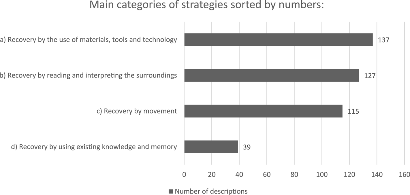
Figure 1. Main categories of strategies from the typology in Table 1 ordered by numbers (decreasing)
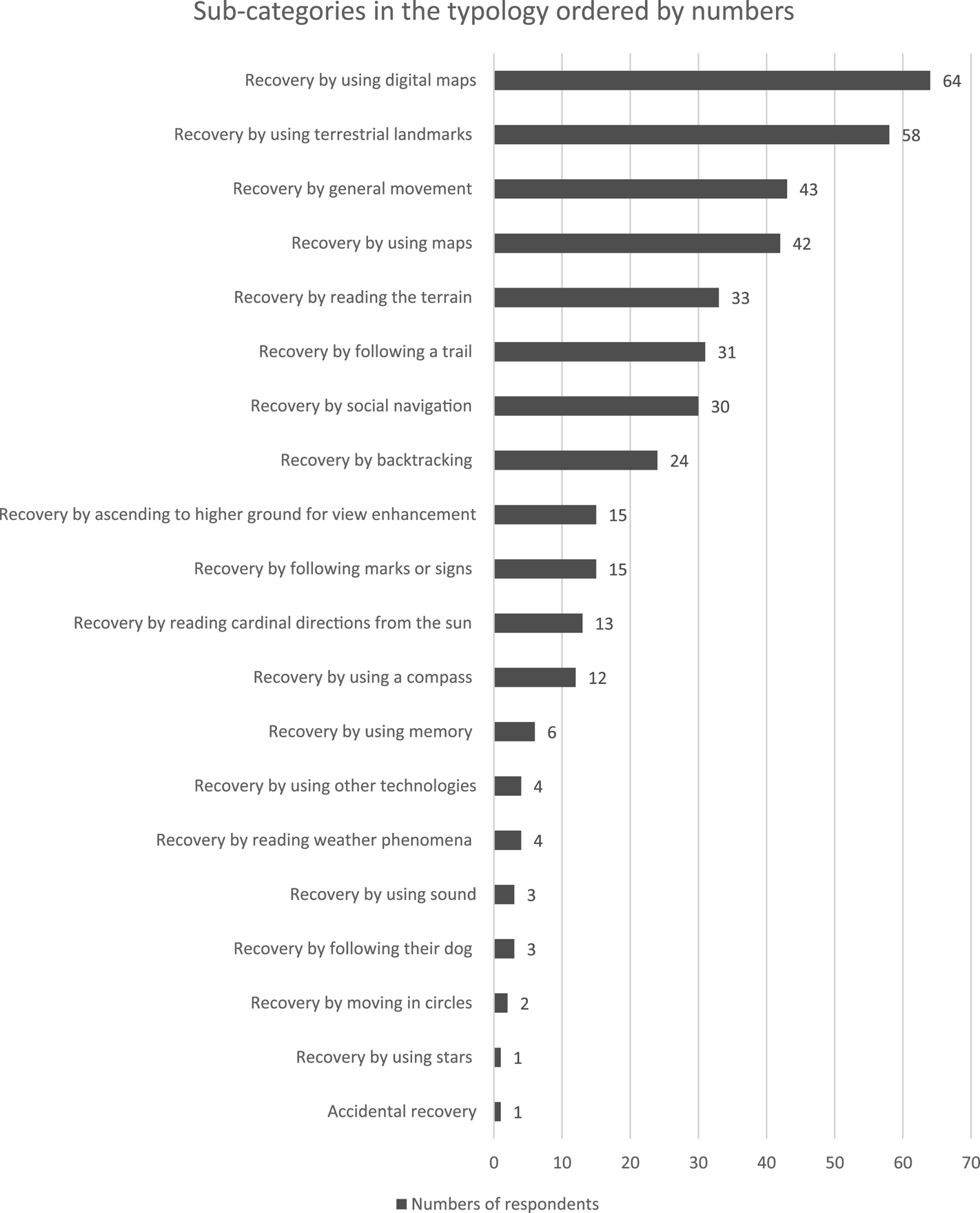
Figure 2. Sub-categories of tactics and moves from the typology in Table 1 ordered by numbers (decreasing)
5. Description and analysis of main findings
In the following, we will analyse the individual sub-categories of our typology as sorted under the main categories:
Main Category: A) Recovery by the use of materials, tools and technology.
5.1 Recovery by using digital maps
The respondents describe that they used a digital map service, like Google maps, to recover from being disoriented. In this category, we have included all described use of digital map services, locational services (including ones embedded in social media services and apps such as SnapChat), both on smart phones and more specialised devices like hand-held GPS-units.
Given the age distribution of the respondents and the fact that Norway is a country with a high digital penetration and use of Internet services – in the age range 16–79 years, 93% use the Internet several times a day (Statistics Norway, 2022) – it is perhaps no surprise that the highest number of respondents (64/22 ⋅ 6%) report that they turned to digital maps and systems when recovering from being lost. Many of the respondents report using Google maps. This is not necessarily an optimal service when it comes to map quality in the outdoors, but still it has been helpful for recovering the bearings for many of the respondents. Google maps on contemporary smartphones also indicates moving/phone direction by displaying a directional pointer by the blue-dot indicator that shows location on the map. This is, of course, also helpful when setting direction.
5.2 Recovery by using maps
In this category, with 14 ⋅ 8% of the respondents, there are descriptions of the use of traditional, non-digital (paper based) maps for navigation to recover from being lost. When travelling and trekking in nature, there is a tradition for carrying and using paper maps, and there is also a general security recommendation in ‘the Norwegian mountain code’ (Mauren, Reference Mauren2015; The Norwegian Trekking Association, n.d.) to always carry these kind of maps as a back-up to digital ones, as digital maps are vulnerable to loss of battery power, loss of coverage or technological faults. We can speculate that this category being relatively low in numbers is due to the age range of the respondents, of paper maps not being seen as optimal for recovery, of the reported activities and trips being of too short duration to validate these kind of safety measures, or of a combination of these and other factors.
5.3 Recovery by following marks or signs
At 5 ⋅ 3% of total answers, the respondents in this category describe that they used signage, cairns or other man-made markings to re-establish location. We consider marks and signs as examples of wayfinding artefacts that are put in place to help people find their way and location. Marks and signs might then, of course, also be used if people lose their way and need to recover. The descriptions of this approach are quite low in numbers, and this can indicate that visible marks and signs prevent people from experiencing disorientation, but a mark, sign or cairn gives no guaranteed assurance for the user to experience certainty about direction or location. Also, as mentioned, marks and signs can act as landmarks in wayfinding processes, but we have chosen to sort them into a distinct category based on explicit mentions in the respondents' descriptions, and the fact that they are put in place specifically for way-showing purposes, whereas landmarks (see Section 5.5) can be objects and features that are not man-made with the specific intention of showing the way.
5.4 Recovery by using a compass
The next category is connected to the reading of cardinal directions, but here a tool in the form of a compass – traditional or digital – is used, either on its own or in combination with a map, to set direction, and then this is used to recover by getting bearings and/or location. 4 ⋅ 2% of the respondents describe the use of a compass to re-orient themselves. Using a compass in combination with a map requires skills to be done in a precise way, whereas just reading out cardinal directions from the compass is quite easy to do. We do not have differentiators between these two ways of using a compass – as a standalone or in combination with a map – in the descriptions of recovery in our survey, but we have 328 respondents (47% of total) answering that they use a compass in combination with maps ‘sometimes’, ‘often’ and ‘always’ for general wayfinding purposes in nature.
Main Category: B) Recovery by reading and interpreting the surroundings.
5.5 Recovery by using terrestrial landmarks
This is the second largest category at 20 ⋅ 5% (58). The respondents have reported the use of any type of terrestrial landmark – natural or man-made – to recover. In wayfinding activities, landmarks can be of many forms and kinds, and we have specified them in our typology to be terrestrial as an intended pleonasm to separate them from, for example, celestial objects like the Polaris star, which might function as landmarks without being land-based (Richter and Winter, Reference Richter, Winter, Richter and Winter2014). Richter and Winter (Reference Richter, Winter, Richter and Winter2014) refer to WordNet (as a ‘a semi-formal ontology or lexicon of concepts’), and the level 0 definition of ‘landmark’ in WordNet is close to how we have interpreted the use of the term in our research and following typology.
• ‘S: (n) landmark (the position of a prominent or well-known object in a particular landscape) ‘the church steeple provided a convenient landmark’ (WordNet, n.d.).
From this, a landmark in our typology is ‘something’ conspicuous, land-based and external from the user that is used as a reference point for orientation, but which have not necessarily been purposefully set up as part of a signage and wayfinding system. Marks and signs (see also Section 5.3) can function as landmarks, but we have decided to isolate them in a separate category as we think this granularity is of interest, also since marks and signs in nature mostly are put in place for way-showing purposes, whereas a landmark can be any kind of – even moveable – object or phenomena (Barrie, Reference Barrie2020, pp. 17–19). We also find support for our definition of terrestrial landmarks in the following quote from Richter and Winter (Reference Richter, Winter, Richter and Winter2014, p. 6): ‘ … landmarks are not special in this respect. Any classification of objects in geographic space is to some extent arbitrary, and has its prototypes and its boundary cases.’
The category includes both descriptions of natural landmarks like a prominent mountain peak, and man-made landmarks like a TV tower or a building. Landmarks as points of reference in wayfinding activities have been thoroughly described in navigation and wayfinding literature across contexts,Footnote 3 and also in ‘survival guide’ books on how to stay safe in the outdoors (Angier, Reference Angier1956; Brown, Reference Brown1983). The importance of this category in our survey data can thus be seen as confirmation of earlier research on the use of landmarks in navigation and wayfinding.
5.6 Recovery by Reading the terrain
At a 11 ⋅ 7% response rate, the respondents describe that they have read the terrain around them to re-establish location and bearings. This might be in the form of seeing and recognising a landscape, seeing and following a stream, recognising a distinct type of vegetation, reading the angle of terrain incline in a white-out or angle of waves in a boat, in line with some descriptions by Gatty (Reference Gatty1999 [1958]) and as displayed in illustrations in the guidebooks by Wainwright (Reference Wainwright2005 [1955]). These terrain readings are then in turn used for establishing location or direction. There can be overlap between these descriptions and the descriptions involving natural landmarks, but we have sorted them in this separate category when the descriptions are more general descriptions of ‘reading’ the terrain or the layout of the land, and not descriptions of orientation with prominent landmarks. Here are some examples:
‘I was out hunting, unknowingly I passed a post, I used the valley to find my way.’
‘Walked towards a stream and followed it.’
‘I stopped to read my surroundings and found myself (my position) on the map.’
‘I recognised the formation of the terrain.’
‘In a white-out while skiing, we oriented by the incline of the terrain to move from the mountains and down into the woods.’
‘Made sure that the waves hit the boat at a constant angle until I reached the shore.’ [Our translations.]
It follows from these descriptions that a reading of the terrain in most instances would need to be coupled with other kinds of knowledge to re-establish location. By, for example, seeing a valley with a river flowing in a direction, one would need to know that this river is flowing from or towards a known location or direction to use this terrain-information to establish certain knowledge of location; references in the terrain can be certain locations per se, but they can also be information that, coupled with other kinds of knowledge, leads to certain knowledge of location and/or bearings.
5.7 Recovery by using cardinal directions from the sun
Navigation by cardinal directions from the sun is a navigational method with a long history, but in our survey, it received relatively few descriptions with numbers at 13, or 4 ⋅ 6%. The respondents describe using the sun's position to set cardinal direction and then applying this knowledge of direction to re-establish bearings and place. By the descriptions gathered in our survey, knowledge of reading the sun for cardinal directions is something that the respondents brought with them into the situation of disorientation, and then applied successfully to recover. As such, it is a type of knowledge and approach that in some of the descriptions can be sorted in a broader category of ‘natural navigation’ (Gooley, Reference Gooley2010), where the interpretation of natural phenomenon is key, but where certain kinds of knowledge or skills need to be applied in the situation to be able to make use of these natural phenomena to establish direction and to reorient. (With this aspect – of bringing and using existing knowledge into the situation – in mind, the sub-category could also have been sorted in the Main Category: D) Recovery by using existing knowledge and memory (individual or shared), but we have chosen the act of reading the sun's position as the main feature and accordingly sorted it under Main Category: B) Recovery by reading and interpreting the surroundings.)
Main Category: C) Recovery by movement.
5.8 Recovery by general movement
The third largest sub-category at 15 ⋅ 2% is reorientation by general movement. In this category, the respondents describe that they recovered by moving about in a general manner until they recognised their location or bearing, without specifying a certain intent, aim or direction of the movement. What can be interpreted from these descriptions is that the respondents continued to move about, and then recovered their location and/or bearings from ‘stumbling upon’ something that enabled them to recover, such as a trail, a sign or a landscape feature, without the respondents necessarily describing this as a targeted intention. As such, this category is perhaps the one that is most unclear. The respondents only describe ‘some kind of movement’ as their approach without necessarily providing any specific direction, aim, strategy or detail of the movement. We see in the collected descriptions that people actually (intentionally) use movement as a behaviour for recovery. Even though the movements are not described as specific or goal directed, they are described as the main actions that led to recovery. Here are some example descriptions where general movement is central:
‘Walked around until I found someplace recognisable.’
‘I think we walked in a direction until we stumbled on a walking path and followed that.’
‘Keep moving forward. Eventually you'll end up in a circle and find your way back.’
‘Just continued to walk until I found something I recognised.’ [Our translation.]
‘Continued to move in assumed correct direction. It proved to be correct even though I had moved away from the original path.’ [Our translation.]
Since it is the third largest sub-category in our sampled material, it has also influenced our decision to establish Recovery by movement as a main category on a strategical level in the typology. Both the main category and the sub-categories under it are also influenced by Wiener et al. (Reference Wiener, Büchner and Hölscher2009, p. 156) breaking navigation into the category ‘locomotion’ (along with ‘wayfinding’), and by Barker (Reference Barker2019) defining ‘spatial behaviour’ as one of three wayfinding behaviours (along with ‘semantic’ and ‘social’).
5.9 Recovery by following a trail
This category amounts to 11% of the responses. The respondents describe that they have recovered by following one or several trails in the landscape until they could re-establish their positions. We can presume that the respondents might not have a certain sense of location or direction even while being on a trail, but by following a trail, it led to re-establishing this sense.
5.10 Recovery by backtracking
In this category, 8 ⋅ 5% of the respondents describe that they retraced – or backtracked – their previous movements to return to their last known location. This described retracing might be in the form of following the trail backwards, or moving back to a known landmark or other point of reference to establish location. This approach can be likened to the concept of leaving and following breadcrumbs; as described in the fairy tale of Hansel & Gretel,Footnote 4 and more recently used analogously as a navigational design pattern in graphical user interfaces and on web pages. The responses are sorted into the Main Category: C) Recovery by movement, but could also be sorted into Main Category: D) Recovery by using existing knowledge and memory (individual or shared), as they can be perceived to involve both movement (backtracking) and use of memory or other existing knowledge.
5.11 Recovery by ascending to higher ground for view enhancement
In this category, 5 ⋅ 3% of the respondents describe that they moved to higher ground, like a hilltop, to get a better overview of the surroundings and thus use the better view to establish location and bearings. This is an approach to vertically improve visual access – which is also described by Jeffrey (Reference Jeffrey2019, p. 31) who refers to Hill (Reference Hill1998a), and by Gatty (1999 [Reference Gatty1958], p. 71) – where the respondents use the terrain to their advantage, but which does not necessarily involve the use of tools or specific knowledge besides the fact that higher ground gives a better overview. Accordingly, moving to higher ground would be an approach that happens in combination with reading the surrounding landscape and/or using landmarks through the resulting improved visual access. As such, this tactic – moving to higher ground – is carried out first for then to enable a better reading of the surroundings. This sub-category can therefore be seen as a two-step process that we have sorted into the two strategies Main Category: C) Recovery by movement and Main Category: B) Recovery by reading and interpreting the surroundings.
Main Category: D) Recovery by using existing knowledge and memory (individual or shared).
5.12 Recovery by social navigation
In this category, with 10 ⋅ 6% of the numbers, the respondents describe that they recovered by some kind of interaction with other people as their approach. This might be in the form of asking other hikers for directions, seeing other people further on and following them, or calling someone on the phone for help with directions. Social navigation is described in previous literature (e.g. Mollerup, Reference Mollerup2005; Haddington, Reference Haddington2013; Barker, Reference Barker2018; Dalton et al., Reference Dalton, Hölscher and Montello2019; O'Connor, Reference O'Connor2019), and it might be explicit like when asking for directions, or more implicit like when mimicking others' behaviour and movement. Since the collected descriptions are from situations in the outdoors – with most likely few other people around – we can speculate that instances of social navigation for recovery might be more frequent in more densely populated contexts.
5.13 Recovery by using memory
In this category, a total of six respondents (2 ⋅ 1%) describe that they have used memorised routes, terrains, landmarks or other features to recover from being disoriented. This category will thereby also include the active use of mental images or cognitive maps of the landscape at hand (Downs and Stea, Reference Downs and Stea1977). Navigation by memory is accordingly an ‘internal’ procedure that individual respondents put to use – although a group of travellers might combine knowledge stored in individual memories to way-find (which would then also make it social). The respondents describe the use of memories from previous visits to the area to recover, or the use of memorised route, survey or destination knowledge (Wiener et al., Reference Wiener, Büchner and Hölscher2009, p. 156). The memories might stem from route descriptions, maps or other sources of information, even if it is their first visit to the area. These ‘mental models’ of the places, routes, landscape and surroundings can generally be in many forms, and the stimuli material will affect the formation of the memories and possible cognitive maps in the users' minds. Even though they are not mentioned explicitly in the responses, the use of cognitive maps (Tolman, Reference Tolman1948; Tversky, Reference Tversky1992; Kitchin, Reference Kitchin1994; Portugali, Reference Portugali1996; Schneider and Taylor, Reference Schneider and Taylor1999; Bell, Reference Bell and Ramachandran2012; Eichenbaum, Reference Eichenbaum2017; Hou et al., Reference Hou, Rashid and Lee2017; Moser et al., Reference Moser, Moser and McNaughton2017; Nazareth et al., Reference Nazareth, Weisberg, Margulis and Newcombe2018) among the respondents would be sorted in this category. As documented in research (Eleanor et al., Reference Eleanor, David, Ingrid, Catriona, John, Richard and Christopher2000; Spiers and Barry, Reference Spiers and Barry2015), the hippocampus is central in the handling of memories and in the formation of cognitive maps (O'Keefe and Nadel, Reference O'Keefe and Nadel1978). Eichenbaum (Reference Eichenbaum2017) argues that the strength of the hippocampus in relation to the use of cognitive maps is the role of the hippocampus in organising experiences in memory: a cognitive map is something the user will ‘hold’ in memory. The idea of a ‘map’ is figurative in this sense; and these memories, or mental models – visual or in other modalities – can come in many shapes and forms among different persons and cultures (Downs and Stea, Reference Downs and Stea1977; Widlok, Reference Widlok1997; Roberts, Reference Roberts2012; Walton, Reference Walton2014; O'Connor, Reference O'Connor2019).
5.14 Miscellaneous descriptions
The remaining categories are so small that they can be seen as more unusual or specialised tactics or moves. Category 5.14 Navigation by other technologies describes the use of other technological equipment than previously described in Main category: A) Recovery by the use of materials, tools and technology, such as military radio communications and wind indicators.
Category 5.15 describes reading (changing) weather phenomena, like waiting out the fog or a white-out, to re-establish location. In these descriptions, weather conditions are likely a contributing factor or what caused the respondents to get disoriented in the first place, so it can be argued that the weather conditions are not necessarily used for navigation, but the change in weather solves the issue of being lost for the respondents, by re-enabling orientation as in Main category: B) Recovery by reading and interpreting the surroundings.
Category 5.16 contains descriptions of actively using sound to establish location. Listening for the sound of a waterfall or distant traffic or other sounds stemming from a known location was used to set current location or bearing in relation to the direction of the sound. We humans are acutely aware of direction of sound through our auditory perception (Batteau, Reference Batteau1967) and the descriptions we have gathered describes how this ability is put to use for orientation as in Main category: B) Recovery by reading and interpreting the surroundings.
Category 5.17 is navigation by letting the dog lead the way and was perhaps the most surprising one: three respondents described that they had recovered by letting their dog take lead and guide them (back) to a known location. There are no descriptions in this category that detail whether they are describing actual guide dogs trained for visually impaired users or other purposes, but by the descriptions we are assuming that we are talking about ‘regular’ dogs. Main category: D) Recovery by using existing knowledge and memory (individual or shared). (In this case, we assume the dogs are using scent memory, scent trails and other sensory stimuli to find the way.)
Finally, two respondents described moving in circles as their approach, one described stellar navigation, and one described recovering by accident; i.e. no strategy, tactic or moves involved besides from perhaps trusting your luck.
6. Discussion
6.1 Disorientation and duration
Our respondents report that they have experienced a feeling of being disoriented for a certain period of time [i.e. not being in what Hill (Reference Hill and Hill1998b, pp. 3–4) describes as a psychological state of ‘knowing where you are’], but have then been able to re-orient themselves by a wide range of reported approaches. In this sense, our use of the term ‘lost’ in Question 13 (see Appendix Table A2) is in a more everyday meaning, where one has temporarily ‘lost the way’. In the Norwegian language version of the survey, the idiom ‘å gå seg vill’ is used. This can be translated to the English term ‘to get lost’, or what Hill (Reference Hill and Hill1998b, p. 7) calls to be ‘turned around.’ Our respondents have managed to recover from this without being dependent on a search and rescue effort by others. In our research, the focus is consequently on how people describe to have solved the situation of being temporarily lost and have been able to reorient themselves. The clear majority (88%) of our respondents reported experiencing being lost for 60 min or less, thus the terms temporarily lost or disoriented seem fitting.
6.2 Behaviours, strategies or problem-solving attempts
Mollerup's (Reference Mollerup2005) nine wayfinding strategies have been influential for our typology. Mollerup (Reference Mollerup2005, p. 43) states that his strategies are ‘primarily aimed at the built environment’, and as such, the identified approaches in our research of the outdoors might not be viewed as fully commensurable with Mollerup's strategies. If we uphold a view of a strict division between built and natural environments, our findings of reported approaches can serve to confirm similarities between what is previously described for wayfinding in urban environments and what has been described in our context of more natural surroundings. The term ‘strategy’ implies an element of planning or strategical thinking.Footnote 5 Mollerup (Reference Mollerup2005, p. 43) defines a (wayfinding) strategy as: ‘ … a rational principle for search, decision, and motion. This definition includes intelligent seeking, but excludes random seeking. Travellers typically practise random seeking when they have lost their way and don't have the faintest idea where they are.’ By this definition and description, Mollerup excludes the situation of being lost for a strategic approach to wayfinding. Adhering to Hill's definition of being lost as discussed above and Mollerup's exclusion of wayfinding strategies when lost, our interpretation of the descriptions we have collected is that they are of a spur-of-the-moment, spontaneous – and hence possibly not strictly speaking strategic – nature, and we see them as attempts at solving an immediate, spatial problem (Downs and Stea, Reference Downs and Stea1977, p. 55) in a potentially stressful (Hill, Reference Hill and Hill1998b, pp. 10–12) situation. As discussed by Barker (Reference Barker2019, pp. 540–541), behaviour can be examined at variable scales. Barker uses Marchionini (Reference Marchionini1995, pp. 72–74) to define that search behaviour can be viewed from four levels of detail and summarises them like this:
• Patterns (groups of strategies or tactics which a person applies to a particular category of problem)
• Strategies (the approach a person takes to a particular problem, ‘sets of tactics’)
• Tactics (‘discrete intellectual choices’)
• Moves (discrete actions such as clicking a mouse or walking to a shelf)
We have, like Barker, employed Marchionini's levels of behaviour in our analysis. We consider the described approaches from our respondents to belong to the three bottom levels: Strategies, tactics and moves. This definition of behaviour scales in combination with the findings, as presented in our typology in Table 1, can thus be seen as self-reported evidence that Mollerup's statement that ‘Travellers typically practise random seeking when they have lost their way … ’ can be nuanced. Our respondents describe that they use available materials, tools, existing personal and collective knowledge, memories, sense-stimuli, terrain readings, and other ego- and allocentric approaches that go beyond the somewhat limited category ‘random seeking’, even when they are temporarily lost. We have chosen to let not only behaviours but also choice of materials, phenomena, tools and technology influence the categories we set up for analysis. For instance, there is one category for the description of the use of digital maps and another for the use of traditional, paper-based maps, because we think it is of interest to categorise with a high level of granularity. The respondents' described actions are all labelled as recovery as this is what is achieved by the actions. Additionally, we consider it likely that available tools, materials and phenomena in combination with knowledge and skills will have influenced the respondents' actions that lead to re-orientation. However, this is not something we have asked the respondents specifically about. In this perspective, what we call a strategy, tactic or move – i.e. a scale of behaviours – are all considered behaviours whether they concern asking someone for directions, ascending to higher ground for view enhancement, reading the terrain, identifying landmarks, the use of materials, tools and technology, or use of knowledge and memory. These behaviours have, in turn, led the respondents to the ‘eureka moment’ where they no longer experience being disoriented.
6.3 Limitations, bias and movement as wayfinding behaviour
Even though it is useful to see our sampled descriptions as instances of a variety of types of wayfinding approaches among the respondents, we would like to reiterate the fact that what we have collected is not observed behaviours; they are self-reported from memory. Additionally, what is described is what the respondents remember to have done (i.e. their ‘behaviour’) to go from a state of experienced disorientation and to an experienced state of orientation. This experienced state of orientation can be achieved by different approaches where some will involve geographical movement (‘backtracking’, ‘move to higher ground’, ‘following a path’ etc.), whereas others experience orientation by behaviours that does not necessarily involve geographical movement (‘using a digital map’, ‘checking for landmarks’, etc.), where the respondents have re-established orientation without reporting to have moved about. Because of this, we think it is useful to define a strategic category where movement is identified as the reported activity that changed the experienced state from disorientation to orientation among the respondents. Also, as described by Koester (Reference Koester2008, p. 57), ‘staying put’ is a common safety recommendation if a person gets truly lost, and we therefore think it is of interest to have a separate category for the descriptions that says movement is what re-oriented our respondents.
The majority of our respondents used the Norwegian language version of the questionnaire (622 out of the total 693 respondents). The collected descriptions of approaches can accordingly be seen to have a Norwegian cultural bias. We did not include any geographical data in the questions about losing the way, so we cannot be absolutely sure about the location of the descriptions. The respondents might be describing situations occurring while being located inside or outside of Norway, and the 71 respondents using the English version of the questionnaire are most likely recruited by international students in the group. There is existing research carried out with the use of digital, videogames-based material on wayfinding, showing that the population in Nordic countries score high on navigational abilities (Coutrot et al., Reference Coutrot, Silva, Manley, de Cothi, Sami, Bohbot, Wiener, Hölscher, Dalton, Hornberger and Spiers2018). This research could indicate that the proportion of respondents answering that they had never or seldom been lost in our survey might have been lower in similar surveys carried out in countries outside the Nordic region (in accordance with scored lower navigational abilities by Coutrot et al., Reference Coutrot, Silva, Manley, de Cothi, Sami, Bohbot, Wiener, Hölscher, Dalton, Hornberger and Spiers2018). As referred to by Gatty (Reference Gatty1999 [1958]) and also by Coutrot et al. (Reference Coutrot, Silva, Manley, de Cothi, Sami, Bohbot, Wiener, Hölscher, Dalton, Hornberger and Spiers2018, p. 2864), there is a tradition of including the sport orienteering – including training in the use of a map and compass – in secondary school physical education in the Nordic countries. We can speculate that this, perhaps also in combination with a strong tradition for using nature for hiking (Ween and Abram, Reference Ween and Abram2012), could heighten navigational abilities in the outdoors in the general population, and perhaps also give better skills in the use of map and compass, which in turn could influence the number of respondents reporting this in our survey. We consider that there is nothing in our research confirming or going against the results from Coutrot et al. (Reference Coutrot, Silva, Manley, de Cothi, Sami, Bohbot, Wiener, Hölscher, Dalton, Hornberger and Spiers2018), but are aware that the cultural bias might affect our results.
7. Conclusion
The findings presented in this paper are concerned with descriptions of a specific setting (being temporarily lost) in a specific context (the outdoors). The proposed typology is a contribution towards describing and categorising wayfinding behaviours, approaches and use of materials employed as a form of problem solving. These descriptions cannot necessarily be replicated in, or be mapped onto, other settings, but we have established similarities between these reported behaviours and methods reported in the literature from other wayfinding contexts. Our typology of descriptions can serve as a contribution to knowledge about wayfinding behaviours, procedures, competences, and use of materials, tools and technology. As a result, it can serve as knowledge in the form of possible patterns to address when designing wayfinding systems for the outdoors, and possibly also for other settings.
The described approaches and the popularity of them can also inform guidelines and educational material on safety procedures and outdoors training. Lunde (Reference Lunde2016) found a sharp increase in rescue operations in the Norwegian mountains over the previous 10–15 years, and we think a contribution to understanding peoples' behaviour when temporarily lost can be of help to educate and train people to avoid getting more seriously lost, and in turn contribute to reduce the need for rescue operations. With the knowledge that the largest group of our respondents reported turning to digital maps when they got lost, we can inform and educate people about the possible benefits and risk of such approaches, and we can educate them about which digital services and tools can be helpful, and also increase their security while being in the outdoors. In addition to the popular Google maps, they can, for example, install more specialised map services, make use of the digital compass on the phone and make sure that they notice landmarks in the surroundings, both in the planning phases and while under way. Further research of this kind of problem solving in other settings could be undertaken: how people recover from being disoriented in cities, in airports, in hospitals and other complex environments, buildings and sites. By researching procedures from other settings, one might continue to identify context specific approaches and possible overlaps in approaches also between contexts. Also, navigational approaches from other settings have been used with success in designed wayfinding systems, like, for example, the use of cardinal directions in wayfinding for mass transport (‘westbound trains’), or the use of ‘artificial’ landmarks for saliency and remembrance in otherwise anonymous hospital buildings.
Competing interests
The authors declare none.
Appendix
Table A.1. Age distribution among respondents

Table A.2. Distribution of answers to question 13
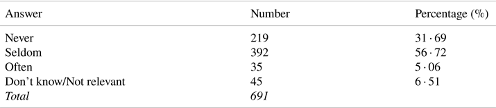
Table A.3. Distribution of answers to question 13.1 ‘Can you remember for how long you experienced not knowing your precise location and what direction you needed to move in?’
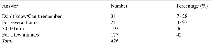
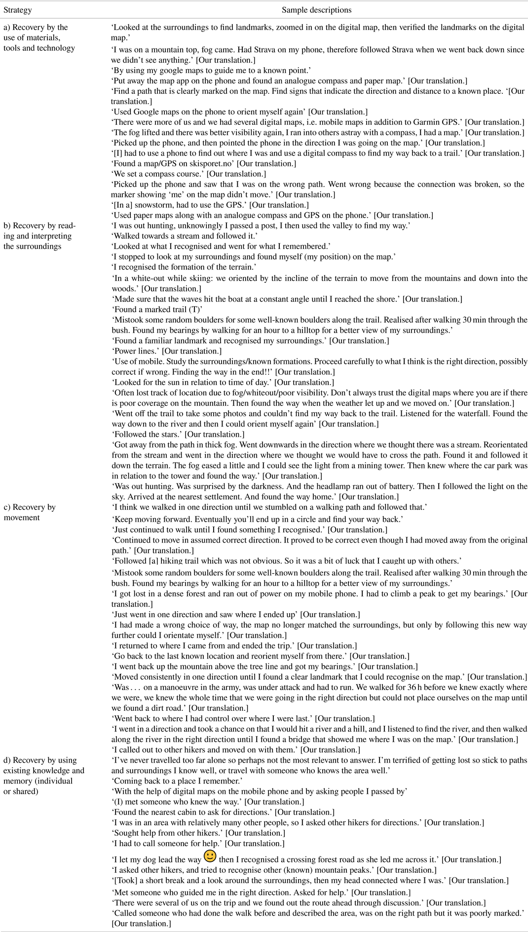
Table A.4. Example descriptions provided by respondents sorted under the main strategies (some of the descriptions will be hybrid and thus fit under more than one strategy and have in Table 4 been sorted and counted accordingly)


 Open access