The Johor–Singapore Causeway was inaugurated on 28 June 1924. With this, Singapore became physically connected to the Malay Peninsula via a 1,056-metre-long raised track across the Johor Strait. Since then, this understated piece of infrastructure has come to underpin many aspects of life in Singapore and Malaysia. Before the COVID-19 pandemic, an estimated 300,000 people crossed between Malaysia and Singapore via the Causeway every day, making it one of the busiest border crossings in the world, and perhaps the busiest of all in Southeast Asia.Footnote 1 The reasons for this transborder travel included daily commutes for work, access to education and health services, as well as shopping and leisure. In addition, people crossed the Causeway to then use either Singapore or Johor as a gateway to destinations further afield. While the pandemic curtailed almost all cross-border movement of people, as of early 2023 trips across the Causeway were approaching their pre-COVID-19 levels.Footnote 2
Beyond the movement of people, this infrastructure enables the flow of vital commodities and goods. Water of varying degrees of purification runs back and forth along the Causeway. Eggs produced in Johor account for the bulk of supply to the Republic, and this southern Malaysian state is also a leading source of palm oil, fruits, vegetables and tubers, pork and fish to Singapore.Footnote 3 In addition, farm operators in Johor ship high-value items such as flowers and ornamental fish to world markets from Changi Airport via the Causeway.Footnote 4 Singapore and Malaysia are also drawn together through a web of supply chains in intermediate inputs—much of which uses the Causeway. The two countries’ most valuable exports and imports to and from each other are integrated circuits, semiconductors, and industrial equipment. Due to the voluminous trade in these items over the years, the two countries have remained each other's second most important trading partner. This relationship has remained constant in the midst of the eclipse of the United States and its replacement by China as both nations’ largest trading partner.Footnote 5
With the 100-year anniversary of the Causeway on the horizon, it is timely to take stock of this unspectacular but vital piece of Southeast Asian infrastructure and its associated representations and meanings. Drawing on a variety of sources, including government documents, maps and newspaper reports as well as existing academic literature, this article sketches the context in which the Causeway was envisaged, constructed and inaugurated, and its relation to the changing political map of what are today the separate independent nation-states of Malaysia and Singapore. We also show how the Causeway may be cast as infrastructure of both connection and division, and consider the range of flows that it has facilitated from the 1920s up to the present. What we are able to cover in the limited space of this contribution is a very small subset of the possible ways in which scholars might examine or conceptualise the Causeway. As such, this essay is intended, above all, as an opening to further scholarly work on the Causeway in the lead up to its centenary next year.
Constructing the Causeway
The building of the Causeway was an ambitious and multi-year undertaking that capped the development of railway connections across Malaya, Singapore and beyond. Driven by the potential of trade enabled by the opening of the Suez Canal in 1869, the colonial British administration developed railway networks in Malaya and Singapore to connect mines and plantations to key ports in the late nineteenth century.
The rail network in the central part of the Malay Peninsula expanded rapidly just before 1900, when due to British influence, the states of Selangor, Perak, Negri Sembilan, and Pahang were brought together as the Federated Malay States (FMS). The first mention of a railway link between Malaya and Singapore was raised in 1899 by the governor of the Straits Settlements (which included Penang, Malacca and Singapore), Cecil Clementi Smith, who argued that such a connection would enable the efficient transport of produce from the former to the latter. However, following a feasibility study, this initial proposal was rejected for cost reasons.Footnote 6 In the following decade, Singapore and Johor rolled out their own rail networks. Singapore's railway opened in 1903 and consisted of a link between Tank Road in the south with Woodlands in the north. In 1909, Johor opened its own north–south rail connection from Gemas to Johor Bahru, which also articulated with the FMS rail network.Footnote 7
Singapore and Johor operated synergistically, with the former serving as the gateway for the latter to ship its plentiful commodities to world markets. In addition, the connection between the FMS and Johor increased the volume of goods and people moving south to Singapore. In 1909, a ferry service across the Johor Strait was set up. This was subsequently upgraded to allow train wagons as well as vehicles to be loaded directly onto the ferries. In 1911, an estimated 11,000 trucks were transported across the Strait and by 1917, this had grown to 54,000.Footnote 8 The ferry service worked ‘day and night’, raising questions about rising maintenance costs.
The idea of connecting Singapore and Johor Bahru by rail was revisited in the context of colonial-era expansion and imagination of a much wider network in and beyond Southeast Asia. In 1918, the railway networks of the FMS and the Kingdom of Siam were connected, enabling direct travel between Johor Bahru and Bangkok. Plans were afoot for subsequent connections to Burma and then India.Footnote 9 In this context, and given the growing demand for a more efficient transport link specifically between Malaya and Singapore, various designs were put forward. The initial proposal of a bridge across the Johor Strait was discarded in favour of a causeway for two main reasons. First, granite was abundant in the local area, entailing a convenient and relatively inexpensive supply of raw material. Second, it was considered that a causeway would be more resistant to bombing than a suspended bridge.Footnote 10
The construction of the Causeway was collectively funded by the Straits Settlements, the FMS, and Johor. The FMS underwrote the cost of the rail connection, the piping and associated infrastructure for transporting water was funded by the Singapore municipality, and the road connection was financed by Johor and Singapore. The last aspect proved somewhat contentious, with negotiations between the Sultan of Johor and the British over the proportion to be underwritten by each party. The British prioritised the rail connection and the Sultanate was particularly interested in the roadway. In the end, they agreed that Johor would fund 70 per cent of the costs for the roadway and Singapore 30 per cent.Footnote 11 Construction began in 1919 and required some 1.5 million cubic yards of granite extracted from Pulau Ubin and Bukit Timah. Involving more than 2,000 labourers, the Causeway cost more than 17 million Straits dollars and took more than four years to build.Footnote 12
The rail service across the Causeway began operating on 17 September 1923, with an initial cargo of mail. It then opened for passenger traffic on 1 October.Footnote 13 Construction on the road connection continued for some time after this, and the Causeway was officially opened on 28 June 1924. The inauguration was an important event, attended by more than 400 people, comprising the Governor of the Straits Settlements and High Commissioner of the FMS Laurence Guillemard, the Sultan of Johor Ibrahim Al-Masyhur, other Malay sultans, civil servants, and members of the business community.Footnote 14
Domestic or international infrastructure?
Given that the Causeway was built long before either Malaysia or Singapore attained their independence and the historically shifting (geo)political relations between what since 1965 have been separate nation-states, it has characteristics of both domestic and international infrastructure. Prior to the Second World War, the British had extensive influence in the FMS and Johor, and Singapore was a colony. Given their management of international relations for all these territories, there was an uninterrupted flow of goods and people across the Causeway. Official correspondence shows that a police and customs office were planned for the Johor side.Footnote 15
The international dimension of the Causeway was evident during the preparations for its inauguration. Initially planned for 1 October 1923 and timed to coincide with the first passenger train service, the ceremony was postponed to the following June. The official reason was that Governor Guillemard was ‘suffering from a slight strain of the right leg’ and, while this did not impede his daily work, his doctors could not guarantee that he would be able to attend large-scale functions.Footnote 16 It is likely that this diplomatic manoeuvre was linked to the ongoing debate about whether Guillemard as the representative of the Crown or the Sultan of Johor should inaugurate the Causeway.Footnote 17 Several letters in local newspapers, including one by a self-identified European, argued that the honour should be given to the Sultan of Johor, given his long reign and record of helping Britain.Footnote 18 However, others thought that, as representative of the British monarch, Guillemard should have the honour.Footnote 19
The inauguration was ultimately moved to coincide with the opening of the road link across the Causeway. The final arrangements entailed a formidable amount of planning and nuanced procedural prowess. Guillemard and the Sultan met in Johor, and the former opened the Causeway by cutting a silken cord. This was done with a golden knife provided by the Sultan of Johor, and with the Johor anthem playing in the background. Both dignitaries then rode across the Causeway to Woodlands in the Sultan's car. Upon arriving there, the roadway was officially opened and a band played the British national anthem.Footnote 20
The Causeway's duality as both a domestic and international infrastructure facility was heightened by the frequent changes in governance arrangements for Malaya and Singapore during and after the Second World War. During the Japanese Occupation, the FMS and Straits Settlements were disbanded, with all states and settlements converted into provinces governed by the Imperial Japanese Army's Malay Military Administration. While Johor and Singapore were separate provinces, they were administered jointly by the 7th Army, which was headquartered in Singapore.Footnote 21 In the immediate post-war period Singapore and Johor were maintained as separate units during the British Military Administration. Following this, Malaya and Singapore went through several political reconfigurations including: the dissolution of the Straits Settlements; the establishment of the Malayan Union and the retention of Singapore under British control in 1946; and then the creation of the Federation of Malaya in 1948 without Singapore. In 1957, Malaya attained independence, Singapore transitioned to self-government in 1959, and in 1963 Singapore merged with Sabah, Sarawak, and Malaya to form Malaysia. In 1965, Singapore left Malaysia.
In theory, the departure of Singapore from Malaysia in 1965 should have solidified the Causeway's identity as infrastructure with an international character. However, despite random document checks on travellers after the separation in 1965, it was only in 1966 that the two countries set up border and immigration controls on either side of the Causeway. Passport checks on the Singapore and Malaysia sides only became mandatory in June and September 1967, respectively.Footnote 22
This domestic and international duality still exists today. The Singapore and Malaysian states have built very large immigration complexes that face each other on either side of the Causeway. Despite these very visible manifestations of sovereignty, road signs in both territories refer to destinations in the other with domestic place names such as Woodlands in Malaysia, and Johor Bahru in Singapore. Furthermore, many commuters avail themselves of the eponymous Intercity (and not International) train service between Johor Bahru and Woodlands, which runs more than ten services across the Causeway every day.
Connecting and separating
In line with its duality as domestic and international infrastructure, the Causeway has been used not only to connect, but also to separate.Footnote 23 In early 1942, the British sought to destroy the Causeway to impede the Japanese advance from Malaya into Singapore. Following their withdrawal from Malaya, the retreating forces blew up the Johor side of the Causeway by targeting a drawbridge and system of locks that allowed water to flow and small ships to traverse the Causeway.Footnote 24 The bombing left a 70-foot gap. While the destruction certainly delayed the movement of Japanese troops, photographs show that the Causeway was subsequently repaired quite quickly.Footnote 25 Upon their return, the British opted not to replace the drawbridge or locks, which entailed a permanent division across the Johor Strait.Footnote 26
Whilst the movement of goods and people resumed in the post-war period, from 1948 the Malayan Emergency also affected the Causeway. During the 12-year period of civil unrest, traffic between Singapore and Malaya was surveilled very closely, contributing to numerous delays. This was accentuated by attacks by insurgents on railway lines, which then shifted a great deal of transport services to road vehicles, which in turn accentuated congestion on the Causeway.Footnote 27
The Causeway's ability to separate as well as connect again came to the fore in a different register after the end of the Emergency. In 1966, citing the parting of Singapore and Malaysia, the Speaker of the Johor state assembly, Haji Ali Raya, called for the infrastructure to be dismantled.Footnote 28 Conversely, in 1980 the Mentri Besar of Johor, Othman Saat, called for an additional link between the two countries to be built to reroute some of the traffic through Singapore as a means of alleviating congestion in downtown Johor Bahru.Footnote 29 The additional link, the Malaysia–Singapore Second Link, eventually came in 1998.
During the COVID-19 pandemic, movement between Singapore and Malaysia by land was the last mode of transportation to be prohibited, with the cross-border movement of people ending on 17 March 2020. While pictures of the Causeway devoid of traffic abounded during this period (see fig. 1), the link was still used to transport freight and goods between the two countries throughout the pandemic.Footnote 30 On 1 April 2022, the land borders between Malaysia and Singapore were reopened.Footnote 31
Figure 1. The Johor-Singapore Causeway (seen from Woodlands, Singapore) unusually quiet during the COVID-19 pandemic (photo by Shaun Lin).
While historical shifts in the Causeway as infrastructure of connection and division are significant in their own right, they also beg important geographical questions. Who has the Causeway joined and separated? What are the key actors and territorial units of analysis concerned? As seen by the financing for its construction as well as the arrangements for its inauguration, Johor has been an intrinsic part of the Causeway's history and raison d’être. Although Johor has been incorporated into Malaysia as a subnational state (negeri) for well over half a century, it retains its special association with the Causeway as well as independent links with Singapore. It is worth recalling that the southern boundary between Malaysia and Singapore was agreed between the Sultanate and the British in a 1928 treaty, and the water that crosses the Causeway originates in Johor. With his perspective shaped by this history, the present Sultan of Johor regularly expresses his opinion on issues pertaining to cross-border issues.Footnote 32 In addition, applying a subnational territorial lens to the Singapore side, Woodlands clearly has a special commercial and infrastructural relationship to the Causeway, albeit one that does not come even close to mirroring the geohistoric material and symbolic investment of Johor.
Trains, drains and automobiles
Upon its inauguration in mid-1924, the Causeway comprised: one functioning railway track, with the second still under construction; a roadway; piping for water; and a pedestrian walkway. Despite subsequent work to expand the link, all of these various aspects of transport and supply are still in operation today. However, in the ensuing decades the relative importance of each has varied over time.
The initial driver for the Causeway was trade, with the rail network regarded as being of key import—particularly by the British. However, at present, there is no rail connection for freight between Malaysia and Singapore. In 2010, Malaysia and Singapore reached a far-reaching agreement on a range of issues, including the railway station in Tanjong Pagar, Singapore.Footnote 33 The station, along with the land of the railway tracks, while inside the city-state, had been managed by the Malaysian railway operator, Keretapi Tanah Melayu Berhad (KTMB). The 2010 agreement comprised significant swaps of real estate between Malaysia and Singapore and, on 30 June 2011, the last train departed from Tanjong Pagar—driven by the Sultan of Johor himself. That said, the Intercity service between Johor Bahru and Woodlands is still in operation and is often booked out, as it takes a mere five minutes to traverse the Causeway.Footnote 34
While water provision has been a consistent aspect of the cross-border link, it came after support for the rail link had been established. By 1900, planners recognised Singapore's relative lack of water, and from 1912 onwards the discussion centred on transporting water from Johor. The mechanisms for organising supply were folded into the design of the Causeway.Footnote 35 In the subsequent decades, water provision has been a recurring concern for Singapore, and means that the Causeway has been bound up in bilateral discussions and legal tussles with Malaysia—most famously involving former prime minister Mahathir Mohamad. Key agreements in 1961 and 1962 have structured the supply and exchange of water. The 1961 agreement lapsed in 2011, but the second agreement will remain in operation until 2061, entailing a consistent flow of water across the Causeway.Footnote 36
Over the years the importance of the rail connection has decreased and transport via the roadway has assumed correspondingly greater importance. While much was made of the rail network between Singapore and Malaya being connected via the Causeway, the same infrastructure also linked the road networks of the two territories. Indeed, a few weeks after the Causeway was in operation, several car enthusiasts departed from Singapore by loading their cars on the train across the Causeway and then driving from Johor Bahru to Kuala Lumpur. The trip took a total of ten hours, and heralded a new era of individual travel for reasons that far exceed the original trade-based rationale for building the Causeway.Footnote 37 Indeed the growth in vehicular traffic surpassed initial projections very quickly, coming to eclipse the volume of rail-based traffic in Singapore and Malaya by the early 1930s.Footnote 38
Notwithstanding the call for the Causeway to be destroyed following the separation between Malaysia and Singapore, it was widened three times between 1964 and 1988.Footnote 39 At present, the Causeway contains three lanes in each direction for vehicles.Footnote 40 Travellers are able to cross via private cars and taxis, long- and short-distance buses, as well as motorcycles. A panoply of websites monitor the Causeway to enable travellers to plan their trips, especially during peak periods.Footnote 41
The pedestrian walkway has traditionally been overlooked and affected by inconsistent policy responses. Initial accounts of the Causeway stressed its more scenic aspect. However, as traffic increased, its leisurely aspect has decreased. In addition, periodic rule-changes have made crossing on foot illegal at various times, and the distance concerned has varied with relocation of immigration checkpoints. At the time of writing, walking across the Causeway was permitted but uncommon.
Where next on the Causeway?
The Johor–Singapore Causeway has now been in operation for a century—its rail service began in September 1923, some nine months before its official inauguration—a period that spans some turbulent times and remappings of political space in decolonising Southeast Asia. It is perhaps unsurprising that the biggest struggle we faced in compiling this commentary was working out which aspects of the Causeway not to cover. That said, with only a handful of significant exceptions,Footnote 42 there are remarkably few published academic studies of this long-established and ongoing infrastructural accomplishment. While the Causeway is mentioned in many publications on Singapore and Johor/Malaysia as well as in work on (dis)connections between them, it has much less often been the object of scholarly analysis in its own right. The centennial of its official inauguration in 2024 provides an opportunity to rectify this—for the Causeway to assume centre stage. The range of possible conceptual, disciplinary and thematic angles through which to do this is vast. By way of conclusion, we offer three broad thematic categories that we believe are particularly fruitful avenues for further research on and through the Causeway at this symbolic historical juncture.
The first, connecting back to the original preference for a causeway rather than a bridge, concerns the nexus of infrastructure and (in)security. We have noted already that colonial British security considerations underlaid the historical decision to build the Causeway, and the irony that it was the British who subsequently detonated part of it in unsuccessful efforts to thwart Japan's military invasion. While the Causeway has since become much less central to Singapore's sense of military vulnerability as possibilities for aerial, maritime or cyber attacks have arisen, it has retained significance in relation to other dimensions of (in)security: from water supply and food security, to fears about narcotics and pandemics. Then prime minister Mahathir Mohamad's idea of a crooked half-bridge on the Malaysian side in 2003 was met with a warning from Singapore in 2005 that an international facility ‘cannot be lawfully demolished without the approval, agreement and involvement of both states’.Footnote 43 The more recent COVID-19 pandemic saw more balanced or reciprocal anxiety about disease transmission across the Causeway, and serves as a reminder of the need to consider historically shifting perceptions of threat as well as opportunities on the Malaysia side of the Johor Straits, as well as in Singapore. Given our own institutional and geographical positioning in Singapore too, it is important to acknowledge the danger of Singapore-centrism in research on the Causeway's infrastructural (in)security dimensions.
While the nexus of infrastructure and (in)security means that the Causeway has become entangled in international concerns about Singapore's relationship to Malaysia (and vice versa), there is also significant further work to be done on subnational dynamics. Thus, our second proposed avenue for future research has to do with the urban and regional developmental effects of the Causeway. We have noted how geographical proximity means that Woodlands has a special commercial and infrastructural relationship with the Causeway and, by extension, with Johor Bahru. Yet the implications of that relationship for Woodlands have rarely been the focus of substantive scholarly analysis, either at the level of planning or in terms of on-the-ground activity.Footnote 44 Similarly, although the material and symbolic relationship of the Johor sultanate to the Causeway has long been widely appreciated, urbanists have historically paid little attention to the constitutive infrastructural role of the Causeway in the development of Johor Bahru (JB). This has begun to change over the past decade as downtown JB has undergone major redevelopment (see fig. 2).Footnote 45 However, there is significant further research to be done on: how proximity to the Causeway is being leveraged for revitalisation of the historic city centre, alongside large-scale real estate schemes and land reclamation projects; and the role of the Causeway in suturing a much more spatially-extensive transborder urban region.Footnote 46
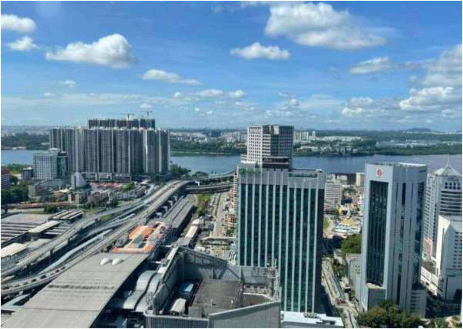
Figure 2. Downtown Johor Bahru following recent urban redevelopment (photo by Shaun Lin).
Third, at smaller scales of analysis, there is important further research to be conducted on the Causeway in relation to issues of human experience and identity. In part, this overlaps with the previous category in that transborder urban development is both spurred by and serves to generate demand for human mobility across the Johor Straits.Footnote 47 However, the experiences of people making these crossings—as commuters, shoppers, students, tourists, and truck, train or taxi drivers, among many others—are phenomenologically significant in their own right.Footnote 48 In a more social or collective register, the Causeway (and its sibling, the Second Link) have enabled the formation of cross-border communities and, by extension, identities. Work on Singaporeans living in Johor has shown how these families seek to navigate the benefits and disadvantages of ‘next-door transnational living’.Footnote 49 Other research has looked at how easy access across the border has allowed Singapore Malay family businesses to develop by catering to the Malaysian market.Footnote 50 There are, doubtless, many communities and subcultures that are enabled and structured by the Causeway, most of which have not so far been documented, let alone featured in scholarly analysis. Finally, in this capacious category of human experience and identity, we might consider the lives and labour of people who variously maintain, clean and administer the Causeway, making it more than an infrastructural ‘non-place’ or an in-between ‘transit space’.Footnote 51
These three sets of suggestions for further research on the Causeway are clearly not exhaustive in either thematic or scalar terms. We anticipate and look forward to a wide range of new work as this often-overlooked piece of Southeast Asian infrastructure gains attention in the lead up to its official centenary.


 Open access