


Volcanism is one of the most studied hazardous events in archaeology; one reason is that volcanic products make this phenomenon relatively easy to recognize. Such events cause unpredictable and catastrophic damage to human societies (e.g., Balmuth et al. Reference Balmuth, Chester and Johnston2005; Cooper and Sheets Reference Cooper and Sheets2012; Grattan and Torrence Reference Grattan, Torrence, Grattan and Torrence2007; Oliver-Smith and Hoffman Reference Oliver-Smith and Hoffman1999). However, some recent studies show that volcanic disasters may also be seen as social rather than environmental phenomena (e.g., Grattan and Torrence Reference Grattan, Torrence, Grattan and Torrence2007:2; Torrence Reference Torrence2019). Sociocultural responses to hazardous events and the subsequent recovery processes vary considerably over time and space, and such responses to abrupt environmental changes remain a challenging research topic (Kintigh et al. Reference Kintigh, Altschul, Beaudry, Drennan, Kinzig, Kohler, Fredrick Limp, Maschner, Michener, Pauketat, Peregrine, Sabloff, Wilkinson, Wright and Zeder2014:18). Recent social-science-based research has tended to emphasize the need to avoid overly sensationalistic interpretations of the catastrophic impact of volcanic events (Grattan Reference Grattan2006; Grattan and Torrence Reference Grattan, Torrence, Grattan and Torrence2007), because the scale of eruptions is not always proportional to their negative impacts on human societies (Sheets Reference Sheets, Cooper and Sheets2012).
Volcanic events tend to be prime movers of sociocultural changes (Hoffman Reference Hoffman, Oliver-Smith and Hoffman1999; Oliver-Smith Reference Oliver-Smith1996; Torrence Reference Torrence2019). The first-century AD eruption of Popocatepetl in Mexico triggered a large-scale movement of refugees in the Basin of Mexico, contributing to the development of large cities such as Teotihuacan, with its impressive monumental architecture (Plunket and Uruñuela Reference Plunket and Uruñuela2005). This indicates that disasters compellingly motivate social actions, creating new power relations and leaders (Torrence Reference Torrence2019:260). Furthermore, volcanos or mountains become part of the human landscape, shaping the worldview of religions, belief systems, and communal memory in both past and present (Scarth Reference Scarth1999). For instance, in Mesoamerica, pyramids were artificial sacred mountains (Fash and López Luján Reference Fash and Luján2009; Freidel et al. Reference Freidel, Schele and Parker1993) that were closely intertwined with diverse entities like peoples, deities, ancestors, natural worlds, and forces (Joyce Reference Joyce, Alt and Pauketat2020; Plunket and Uruñuela Reference Plunket and Uruñuela2008). It is challenging to investigate such perceptions, embedded as they are in oral history, religion, cosmology, and the knowledge of what to do after the sudden occurrence of such hazardous events (Sheets Reference Sheets2016:154). Additionally, novel forms of construction or agricultural techniques may be invented as a consequence of social responses or the adaptation to new landscapes created by volcanic eruptions (Chester et al. Reference Chester, Duncan, Guest, Balmuth, Chester and Johnston2005).
In research on social responses to volcanic eruptions, detailed studies—using a long-term perspective—of individual environmental settings where multiple volcanic events have occurred have recently gained importance (Torrence Reference Torrence2019:263). These provide insightful data that are challenging assumptions regarding human–volcanic interactions, such as the decision to stay or seek refuge elsewhere, who reoccupied post-eruption vacant landscapes, the development of a sense of place, relocation of agricultural land and living space, and food procurement in devasted areas (Chester et al. Reference Chester, Duncan, Guest, Balmuth, Chester and Johnston2005:102–103; Sheets Reference Sheets2016:153–154; Torrence Reference Torrence2019:262–263). The Zapotitán Valley in El Salvador is an ideal place to study such phenomena because of its proximity to several volcanic events (Ferrés et al. Reference Ferrés, Granados, Hernández, Pullinger, Chávez, Taracena and Dinarte2011; Miller Reference Miller and Sheets2002; Sheets Reference Sheets, Rose, Bommer, López, Carr and Major2004, Reference Sheets, Grattan and Torrence2008; Sofield Reference Sofield, Rose, Bommer, López, Carr and Major2004), and Sheets and colleagues have already undertaken significant research on eruptions that affected this area (Sheets Reference Sheets, Rose, Bommer, López, Carr and Major2004, Reference Sheets, Metz, McNeil and Hull2009, Reference Sheets, Cooper and Sheets2012; Sheets et al. Reference Sheets, Dixon, Lentz, Egan, Halmbacher, Slotten, Herrera and Lamb2015)—yet even such relatively recent studies tend to emphasize the physical characteristics of eruptions and their negative impacts, overlooking human creativity. Notably, however, recent advances in archaeological dating techniques and Bayesian analyses provide opportunities to refine local carbon dating chronologies and establish more accurately the timing of eruptions and subsequent post-eruption recovery processes.
This study aims to understand the interaction of volcanic disasters with the rise, development, and decline of San Andrés in El Salvador's Zapotitán Valley, one of the most important primary centers in southeastern Mesoamerica. It seeks to refine the local site chronology in relation to volcanic events by analyzing new excavations from monumental contexts and radiometric dating data obtained by the author at San Andrés from 2015 to 2019. The results suggest that monumental building projects played an important role in the recovery process after all three volcanic events. The participation of local populations in monumental building projects, using volcanic products as construction material, may have been a means of reconstituting group identities after the disaster and of producing durable monuments that anchored the memories of these disasters in local identities at San Andrés.
Volcanic Activities and the Zapotitán Valley
The Zapotitán Valley is located in central El Salvador between the Santa Ana and San Salvador volcanic complexes and is surrounded by other small volcanoes (Figure 1). These volcanoes have an active history over the last 36,000 years (Ferrés et al. Reference Ferrés, Granados, Hernández, Pullinger, Chávez, Taracena and Dinarte2011; Sofield Reference Sofield, Rose, Bommer, López, Carr and Major2004), with three major volcanic events from the prehispanic period geologically identified and dated: the Tierra Blanca Joven (TBJ), Loma Caldera (LC), and El Boquerón (EB) eruptions. Detailed descriptions of the deposits and isopach maps showing the distribution of eruptive products from these eruptions are available in other studies (e.g., Dull et al. Reference Dull, Southon, Kutterolf, Anchukaitis, Freundt, Wahl, Sheets, Amaroli, Hernandez, Wiemann and Oppenheimer2019; Ferrés et al. Reference Ferrés, Granados, Hernández, Pullinger, Chávez, Taracena and Dinarte2011; Miller Reference Miller and Sheets2002; Pedrazzi et al. Reference Pedrazzi, Sunye-Puchol, Aguirre-Díaz, Costa, Smith, Poret, Dávila-Harris, Miggins, Hernández and Gutiérrez2019; Sofield Reference Sofield, Rose, Bommer, López, Carr and Major2004).
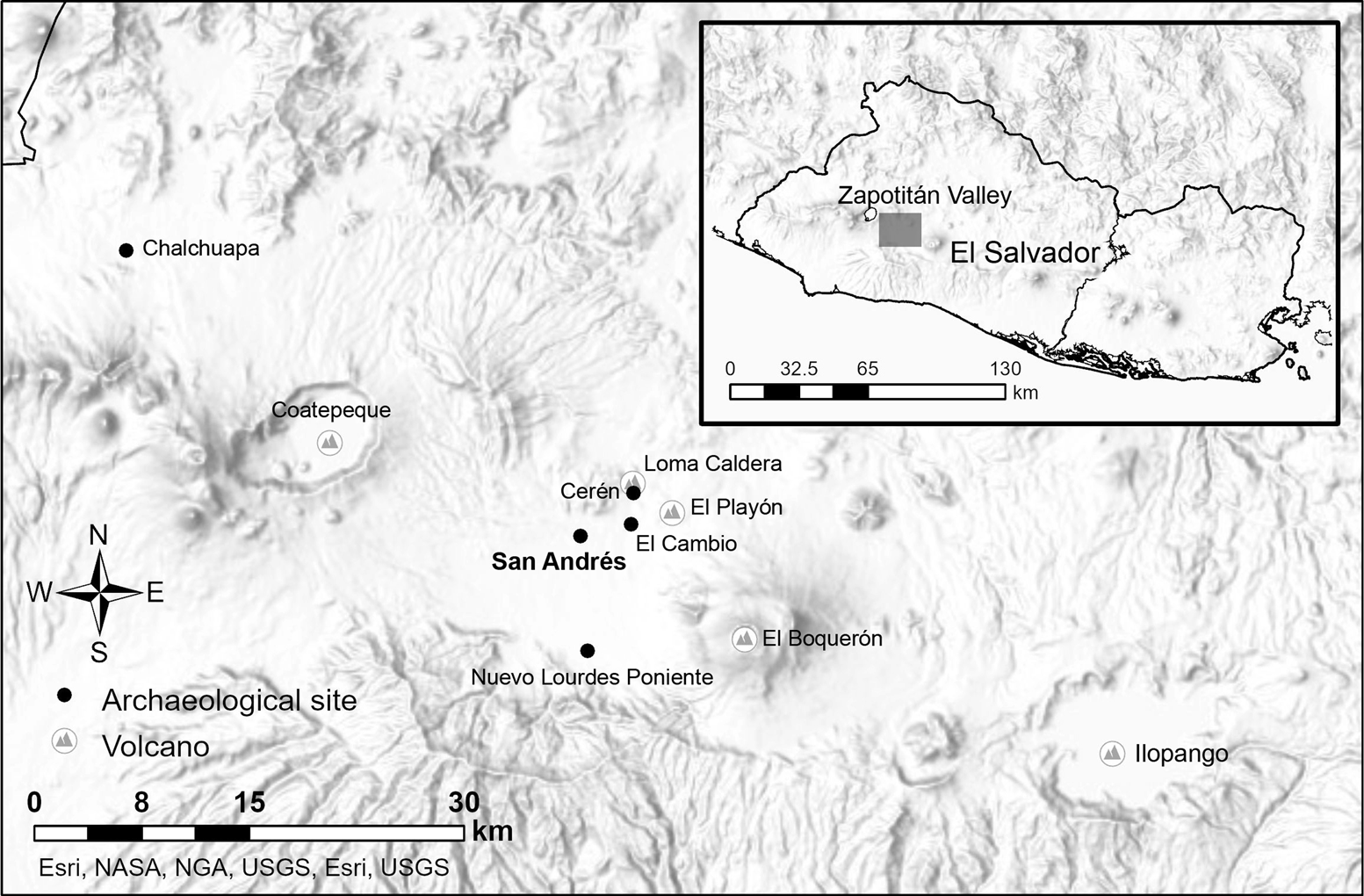
Figure 1. Map of the Zapotitán Valley, El Salvador.
Tierra Blanca Joven Eruption
The TBJ eruption, from the Ilopango caldera, is the largest known volcanic eruption in the Americas (Dull et al. Reference Dull, Southon and Sheets2001, Reference Dull, Southon, Kutterolf, Anchukaitis, Freundt, Wahl, Sheets, Amaroli, Hernandez, Wiemann and Oppenheimer2019; Pedrazzi et al. Reference Pedrazzi, Sunye-Puchol, Aguirre-Díaz, Costa, Smith, Poret, Dávila-Harris, Miggins, Hernández and Gutiérrez2019; Smith et al. Reference Smith, Costa, Aguirre-Díaz, Pedrazzi, Scifo, Plunkett, Poret, Tournigand, Miles, Dee, McConnell, Sunyé-Puchol, Harris, Sigl, Pilcher, Chellman and Gutiérrez2020), with a volcanic explosivity index (VEI) of 6+ (Dull et al. Reference Dull, Southon, Kutterolf, Anchukaitis, Freundt, Wahl, Sheets, Amaroli, Hernandez, Wiemann and Oppenheimer2019). Recent research has provided competing dates for the eruption, including AD 431 (Smith et al. Reference Smith, Costa, Aguirre-Díaz, Pedrazzi, Scifo, Plunkett, Poret, Tournigand, Miles, Dee, McConnell, Sunyé-Puchol, Harris, Sigl, Pilcher, Chellman and Gutiérrez2020) and AD 539–540 (Dull et al. Reference Dull, Southon, Kutterolf, Anchukaitis, Freundt, Wahl, Sheets, Amaroli, Hernandez, Wiemann and Oppenheimer2019). One reason for the difficulty in precisely determining the TBJ eruption date is that the dates fall within a plateau on the 14C calibration curve, between AD 420 and 540 (1600–1550 yr BP).
The TBJ event had a devastating impact on western El Salvador and also affected more distant regions. Tephra deposits greater than 35 cm from the eruption covered an area of more than 20,000 km2 (Dull et al. Reference Dull, Southon, Kutterolf, Anchukaitis, Freundt, Wahl, Sheets, Amaroli, Hernandez, Wiemann and Oppenheimer2019:8). Combining the findings from previous and more recent excavations carried out by the author and others (Begley et al. Reference Begley, Roberto Gallardo, Alex Wilson and Hermann1997; Boggs Reference Boggs1943; McKee Reference McKee2007), the TBJ tephra in San Andrés ranges from a depth of 0 to 52 cm and is divided into four units according to the definition of Dull and colleagues (Reference Dull, Southon, Kutterolf, Anchukaitis, Freundt, Wahl, Sheets, Amaroli, Hernandez, Wiemann and Oppenheimer2019). Unit II is the basal unit composed of pumice lapilli (or unit B; Pedrazzi et al. Reference Pedrazzi, Sunye-Puchol, Aguirre-Díaz, Costa, Smith, Poret, Dávila-Harris, Miggins, Hernández and Gutiérrez2019); unit III (or unit D; Pedrazzi et al. Reference Pedrazzi, Sunye-Puchol, Aguirre-Díaz, Costa, Smith, Poret, Dávila-Harris, Miggins, Hernández and Gutiérrez2019) comprises a lower pyroclastic surge succession (IIIa) and an upper ash fallout succession (IIIb); unit V (or unit E; Pedrazzi et al. Reference Pedrazzi, Sunye-Puchol, Aguirre-Díaz, Costa, Smith, Poret, Dávila-Harris, Miggins, Hernández and Gutiérrez2019) is a double pumice-lapilli fallout; and unit VII (unit G; Pedrazzi et al. Reference Pedrazzi, Sunye-Puchol, Aguirre-Díaz, Costa, Smith, Poret, Dávila-Harris, Miggins, Hernández and Gutiérrez2019) is a white vitric ash layer recognized across El Salvador. A pyroclastic flow deposit, which had a deadly impact on human lives elsewhere, has not been recorded in the valley.
Dull and colleagues (Reference Dull, Southon, Kutterolf, Anchukaitis, Freundt, Wahl, Sheets, Amaroli, Hernandez, Wiemann and Oppenheimer2019:12) argued that the TBJ eruption forced the abandonment of many sites in western-central El Salvador, with the reoccupation of major sites with monumental architecture only occurring in the mid-seventh century. Additionally, Sheets (Reference Sheets, Rose, Bommer, López, Carr and Major2004, Reference Sheets, Grattan and Torrence2008, Reference Sheets, Metz, McNeil and Hull2009) suggested that Cerén was the first site occupied after the TBJ eruption in the Zapotitán Valley and, based on the similarities of cultural components, was not founded by pre-eruption villagers’ direct descendants but instead was colonized by Maya immigrants from the Copan Valley. In contrast, Smith and colleagues (Reference Smith, Costa, Aguirre-Díaz, Pedrazzi, Scifo, Plunkett, Poret, Tournigand, Miles, Dee, McConnell, Sunyé-Puchol, Harris, Sigl, Pilcher, Chellman and Gutiérrez2020:6) argued that local to regional impacts appear to have been restricted to areas within a few hundred kilometers of the vent, meaning the effect of the eruption would have been significantly less drastic on a regional scale.
Loma Caldera Eruption
The Loma Caldera (LC) is 600 m north of the Cerén site and 5 km north of San Andrés. The LC eruption magnitude was VEI 2, and its deposit covered areas within 6 km of the Loma Caldera crater (Miller Reference Miller and Sheets2002:14–15). The Cerén site radiocarbon data indicate a probable date for the LC eruption ranging between AD 610 and 671 (95% probability; McKee Reference McKee and Sheets2002:8). The well-studied LC tephra is divided into 14 units (Miller Reference Miller and Sheets2002), and its thickness as recorded in San Andrés is approximately 25 cm or less. According to Miller (Reference Miller and Sheets2002), two units are identified in San Andrés; the lower part is unit 3, an indurated, laminated, and grayish-brown ash layer, and the upper part, unit 4, is black scoria lapilli. The eruption's magnitude was smaller than the TBJ eruption, covering just a few square kilometers, but more than 5 m of volcanic deposits completely buried Cerén (Sheets Reference Sheets1983, Reference Sheets2002, Reference Sheets, Grattan and Torrence2008). Based on the stratigraphy of El Cambio site's, 2 km south of Cerén, human reoccupation occurred soon after this eruption (Sheets Reference Sheets, Grattan and Torrence2008:79). However, the regional impact of the LC eruptions remains unclear.
El Boquerón Eruption
The El Boquerón volcano (EB) forms part of the San Salvador volcanic complex, and its eruption magnitude was VEI 3. Based on the radiocarbon dating of a tree trunk buried by the eruption, Ferrés and others (Reference Ferrés, Granados, Hernández, Pullinger, Chávez, Taracena and Dinarte2011:842) dated the EB eruption to AD 964–1040 (95% probability), and its volcanic deposits cover a range of 200–300 km2 (Ferrés et al. Reference Ferrés, Granados, Hernández, Pullinger, Chávez, Taracena and Dinarte2011:843; Sofield Reference Sofield, Rose, Bommer, López, Carr and Major2004:151). The eruption's volcanic product is known locally as “San Andrés Talpetate Tuff” (Sofield Reference Sofield, Rose, Bommer, López, Carr and Major2004:151), a term used to describe indurated volcanic tuff (Ferrés et al. Reference Ferrés, Granados, Hernández, Pullinger, Chávez, Taracena and Dinarte2011:841). To clarify its correspondence with the eruption, this study uses the term “El Boquerón (EB) tephra.” The EB tephra is widely recorded in the Zapotitán Valley and is roughly 10–150 cm thick depending on the distance from the vent. It is made up of two units (Ferrés et al. Reference Ferrés, Granados, Hernández, Pullinger, Chávez, Taracena and Dinarte2011:842–843): one is a dark-gray, well-sorted, normally graded, vesicular lapilli deposit, and the other is composed of multicolored, very fine ash layers at the base with abundant traces of plants. The latter unit was widely recorded in the valley and may have affected agricultural activities, being compact and hardened (Sheets Reference Sheets, Rose, Bommer, López, Carr and Major2004:116). It was around 10–30 cm thick in San Andrés. Excavation of San Andrés Mound B suggests that San Andrés's reoccupation occurred several decades after the eruption because a 5 cm thick layer of sedimentary soil was recorded between the EB tephra and the base of Mound B (Card Reference Card, Begley, Gallardo, Card, Wilson, Brown and Herrmann1997:53). However, the timing and impact of the EB eruptions have not yet been determined because of the lack of radiocarbon dates and archaeological data.
Human History of Zapotitán Valley
Based on the ceramic samples found at San Andrés (Begley et al. Reference Begley, Roberto Gallardo, Alex Wilson and Hermann1997), the early occupation of the Zapotitán Valley can be traced back to at least the Middle Preclassic period (1000–400 BC). In the Late and Terminal Preclassic (400 BC–AD 250), several sites spread out on the valley's flood plain; El Cambio—with an earthen mound that was 12 m high and four low mounds—was a possible Preclassic ceremonial center in the valley (Chandler Reference Chandler and Sheets1983). In addition, previous studies reported extensive agricultural fields at San Andrés, Nuevo Lourdes Poniente, and other small sites (McKee Reference McKee2007; Shibata and Herrera Reference Shibata and Herrera2019). Regional ceramics shared traits with Chalchuapa and other southern Mesoamerican sites, such as Izalco Usulután decoration modes and nubbin/conical supports (Begley et al. Reference Begley, Roberto Gallardo, Alex Wilson and Hermann1997).
It is difficult to determine the characteristics and extent of occupation during the Early Classic period (AD 250–600) because of uncertainty regarding the TBJ eruption date and a lack of unequivocable occupation evidence. However, several ceramic groups corresponding to the Early Classic period; Guazapa, Chilanga, and Huiscoyol ceramic groups in the VEC phase in Sharer (Reference Sharer1978) have been reported under and above the TBJ tephra in San Andrés and nearby sites in the Zapotitán Valley (Begley et al. Reference Begley, Roberto Gallardo, Alex Wilson and Hermann1997; Yagi et al. Reference Yagi, Shibata, Moran, Arroyo, Salinas and Paiz2015). These findings suggest that researchers should pay more attention to the context before and after the TBJ eruption while researching its date and impact. In the following sections, this article provides new data relevant to this obscure period.
By the Late Classic period (AD 600–900/1000), large numbers populated the valley; based on settlement patterns, the valley's total population at this time is estimated at 40,000–100,000 (Black Reference Black and Sheets1983:82). San Andrés became the political, economic, and religious center of the region, covering more than 3 km2. Its core comprises the Acropolis; the North (or Great) Plaza; four rectangular mounds measuring 30–50 m in length, 10–15 m in width, and 3 m high (possibly elite residences); and the largest monumental structure in the valley known as the “Campana Structure” (Structure 5, as shown in Figure 2). The core area was surrounded by a commoner residential area (McKee Reference McKee2007). Monumental public buildings were made of adobe and mud plaster, except for Structure 7, which was built of large cut-stone blocks. Previous scholars link San Andrés to the Maya site of Copan based on its layout and an impressive cache that included a highly elaborate eccentric flint, a stingray spine, Spondylus shells, and Copador Polychrome vessels (Begley et al. Reference Begley, Roberto Gallardo, Alex Wilson and Hermann1997; Boggs Reference Boggs1943; Dimick Reference Dimick1941; McKee Reference McKee2007; Mejia Reference Mejia1984). Although the settlement survey recorded other Late Classic sites in the valley (Black Reference Black and Sheets1983), only Cerén, a commoner village entirely buried by the LC eruption, has been investigated in detail (Sheets Reference Sheets1983, Reference Sheets2000, Reference Sheets2002; Sheets et al. Reference Sheets, Dixon, Lentz, Egan, Halmbacher, Slotten, Herrera and Lamb2015). It has been assumed that Cerén commoners attended special ceremonies at San Andrés and obtained exotic items from far away, such as obsidian, jade, and Copador Polychrome vessels, through participation in a broad economic network (Sheets Reference Sheets2000; Sheets et al. Reference Sheets, Dixon, Lentz, Egan, Halmbacher, Slotten, Herrera and Lamb2015). The use of volcanic material at Ceren has also been pointed out: the sacbe (“white road” in Yucatec Mayan) was built with material from the TBJ eruption (Sheets et al. Reference Sheets, Dixon, Lentz, Egan, Halmbacher, Slotten, Herrera and Lamb2015:355). However, relations between San Andrés and Cerén remain unclear because of the lack of investigation at San Andrés.
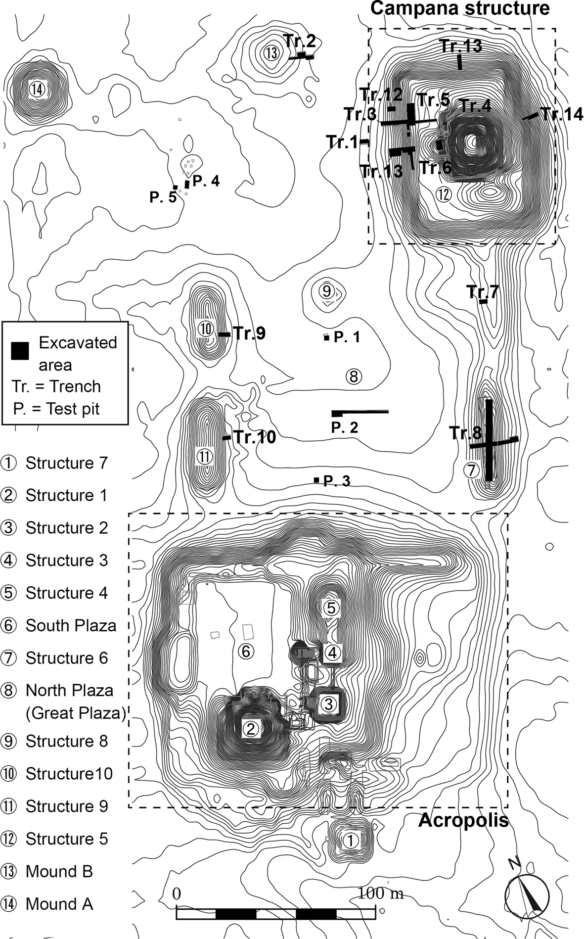
Figure 2. Plan of San Andrés showing structures and excavated areas.
During the Early Postclassic period (AD 900/1000–1200), the valley's population is estimated at 38,000–90,000 (Black Reference Black and Sheets1983:82). San Andrés may still have been the primary center in the valley but was likely influenced by Pipil migrants from Central Mexico (Black Reference Black and Sheets1983:89). Local architectural materials and techniques drastically changed, from earthen materials to the use of cut volcanic tuff blocks (Begley et al. Reference Begley, Roberto Gallardo, Alex Wilson and Hermann1997). In addition, Mixteca-Puebla-style ceramics, locally known as Bandera Polychrome, have been reported for this period (Begley et al. Reference Begley, Roberto Gallardo, Alex Wilson and Hermann1997; Camacho and Díaz Reference Camacho, Díaz, Arroyo, Salinas and Paiz2015). The EB eruption occurred between AD 964 and 1040 (Ferrés et al. Reference Ferrés, Granados, Hernández, Pullinger, Chávez, Taracena and Dinarte2011:842). However, the causal link or links, if any exist, between the Pipil migration, changes in materials and techniques, and the EB eruption are still unknown.
As described previously, prolonged and consecutive human activities have been recorded in the volcanically active Zapotitán Valley. However, we do not yet understand when and how social complexity arose in the region, when San Andrés became the primary regional center, or about the process of its development and collapse. Furthermore, how these events relate to the aforementioned periodic volcanic events is unclear. To fill these gaps, this study presents new data clarifying our understanding of the architectural sequences, construction techniques, and radiocarbon dating at San Andrés, focusing on the largest monumental structure known as the Campana and its surroundings. These results challenge the previous understanding of the site's history and of relationships between human and volcanic activities in the valley.
Excavating and Dating San Andrés
Datasets
This article examines two datasets: (1) excavation data from the Campana Structure and its surrounding area at San Andrés carried out by the author and his colleagues during 2015–2019 and (2) new and existing Zapotitán Valley radiocarbon assays. Given that the Acropolis was already extensively excavated and reconstructed (Amaroli Reference Amaroli2015; Boggs Reference Boggs1943; Dimick Reference Dimick1941), our excavations focused on the Campana Structure, a pyramidal structure atop a large basal platform. The platform measures approximately 85 × 65 m and is 7 m high in its final form, and the pyramidal structure measures approximately 35 × 40 m and is 13 m in height (Figures 2 and 3). Previous excavations of the Campana Structure carried out by Begley and colleagues (Reference Begley, Roberto Gallardo, Alex Wilson and Hermann1997) focused on the pyramidal structures and the south half of the platform's west face. However, its dimensions, forms, and architectural sequences, especially in relation to its initial construction, remain unclear. To fully reveal the structure's construction history, excavations were carried out in 2015–2019 on the centerline and north half of the west face, as well as on the north and east faces of the platform. Four rectangular structures and the North Plaza, areas never before investigated, were excavated to better understand the site's development; other open areas were also investigated to determine early occupation. The on-mound excavation units were 2 × 4 m long and, if necessary, were extended to better understand architectural features or sequences. Off-mound units, especially on the North Plaza and open areas, were 2 × 2 m long and extended as needed. They were excavated at arbitrary 20 cm levels unless cultural features or stratigraphic changes were detected. In total, excavations uncovered an area of 631 m2 and 1–8 m deep depending on the unit: they included eight excavation units on the Campana Structure, 10 in the North Plaza, and four on low rectangular mounds surrounding the North Plaza (Figure 2). The stratigraphic and architectural sequences of the Campana Structure and other structures are shown in Supplemental Figure 1.
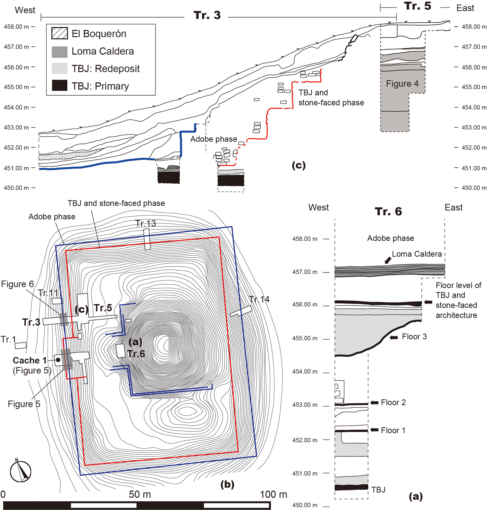
Figure 3. Plan and sections of the Campana Structure (Structure 5): (a) north section of Tr.6, (b) plan of the Campana Structure, and (c) north sections of Tr.3 and Tr.5.
The other dataset consists of 27 radiocarbon dates from the Campana Structure and other public buildings in San Andrés (Supplemental Table 1). Sixteen charcoal samples from the Campana Structure came from different construction phases: the TBJ and earth phase, the TBJ and stone-faced phase, and the adobe phase. Another six charcoal samples came from Structure 6, a rectangular adobe structure on the North Plaza built above the LC tephra and renovated at least twice. Structures 9 and 10, two additional adobe superstructures built on the North Plaza above the LC tephra, each provided one charcoal sample. Finally, two samples came from the context under the TBJ, and one sample was recovered in the Late Classic bell-shaped pit uncovered near Mound B. All samples were run using accelerator mass spectrometry (AMS) radiocarbon techniques at the Laboratory of Radiocarbon Dating at the University of Tokyo Museum, Japan.
Also included in this analysis were four additional radiocarbon dates for samples recovered from burned middens located in a residential area (McKee Reference McKee2007:285, 296). Two were found beneath the EB tephra, and the other two were beneath approximately 10–20 cm thick volcanic deposits called the talpetate inferior, possibly from an eruption of the San Salvador volcano complex, probably Los Chintos (McKee Reference McKee2007:50). However, considering other geological and vulcanological studies in the Zapotitán Valley (Ferrés et al. Reference Ferrés, Granados, Hernández, Pullinger, Chávez, Taracena and Dinarte2011; Miller Reference Miller and Sheets2002; Sofield Reference Sofield, Rose, Bommer, López, Carr and Major2004) and the stratigraphic location between the TBJ and EB tephra, this layer could be the LC tephra. As seen in Supplemental Table 1, the calibrated dates of A-12580 and A-12581 are AD 425–650 (95% probability), supporting this assumption.
Additionally, this study includes and reexamines previous radiocarbon assays to assess the regional chronology (Supplemental Table 2). Eight Cerén samples and two from El Cambio were analyzed (McKee Reference McKee and Sheets2002:7; Sheets Reference Sheets1983:7; Slotten Reference Slotten2015:72). Given that the LC eruption entirely buried Cerén, the dating of these samples is near the eruption date. The El Cambio samples are from the test pits but were stratigraphically located between the LC and EB tephra (Chandler Reference Chandler and Sheets1983:111). Three human skeletal remains from Nuevo Lourdes Poniente were also included in this study (Ichikawa et al. Reference Ichikawa, Roberto Gallardo and Alvarado2014): these three burials were associated with the Late Classic polychrome vessels (Gualpopa and Arambala group in Sharer [Reference Sharer1978]) found at the site. Finally, four samples associated with the EB tephra were included. These samples are carbonized tree trunks recovered 2.5 km north of the El Boquerón crater (Ferrés et al. Reference Ferrés, Granados, Hernández, Pullinger, Chávez, Taracena and Dinarte2011:842). Calibration of the radiocarbon dates was carried out using OxCal v.4.4.2 and the IntCal20 calibration curve (Bronk Ramsey Reference Bronk Ramsey2020; Reimer et al. Reference Reimer, Austin, Bard, Bayliss, Blackwell, Ramsey, Butzin, Cheng, Lawrence Edwards, Friedrich, Grootes, Guilderson, Hajdas, Heaton, Hogg, Hughen, Kromer, Manning, Muscheler, Palmer, Pearson, van der Plicht, Reimer, Richards, Marian Scott, Southon, Turney, Wacker, Adolphi, Büntgen, Capano, Fahrni, Fogtmann-Schulz, Friedrich, Köhler, Kudsk, Miyake, Olsen, Reinig, Sakamoto, Sookdeo and Talamo2020).
This study uses Bayesian statistics to refine the chronology and the estimated construction phase dates in relation to volcanic activities. To this end, identifying problematic samples is important because contaminated materials, such as old wooden materials or materials from old contexts (e.g., Inomata et al. Reference Inomata, Raul Ortiz and Robinson2014), are often introduced at sites with long and successive occupations. Considering the stratigraphy, associated ceramic types, and quality of the samples (especially their 13C value) and of the dated materials, an inconsistent date known as an “outlier” can be identified before Bayesian modeling is conducted. This process identified samples TKA-17789, 17794, 17795, 17797, and 19377 as outliers. Human remains from Nuevo Lourdes Poniente have low 13C values, suggesting these samples could be problematic. However, stratigraphic data, calibrated dates, and associated ceramics are consistent, making them suitable for the Bayesian model.
Bayesian analysis with OxCal can also identify problematic dates through the statistical likelihoods of outliers called “agreement indices,” which need to be 60% or higher for the agreement to be considered good (Bronk Ramsey Reference Bronk Ramsey2009:1025). The analysis identified TKA-17793, 19376, 19381, and 21284 as outliers and reached the most plausible model by incorporating stratigraphic information and archaeological materials. Owing to the uncertainty of the TBJ eruption date, this study used AD 420–540 as the uniform distribution in the model, meaning that the event could have occurred at any point within this time period with equal probability (Bronk Ramsey Reference Bronk Ramsey2009:1026). For the LC eruption, Cerén's dates were combined into the model (McKee Reference McKee and Sheets2002; Sheets Reference Sheets1983; Slotten Reference Slotten2015). However, only two samples used current AMS dating techniques (A-10743 and AA105791). Because the conventional age ranges for other Cerén data tend to be large due to the limitations of the technology available at that time, those with ranges of ±100 years above (ELS-40 and TX3120) are excluded from the model. To calculate the EB eruption date, data provided by Ferrés and colleagues (Reference Ferrés, Granados, Hernández, Pullinger, Chávez, Taracena and Dinarte2011) were included.
Stratigraphic and Architectural Sequence
Excavations reveal more evidence of Preclassic period occupation than previously thought (Black Reference Black and Sheets1983:88). The amount (around 30% of the ceramic sample) and variations of ceramic types in the Late and Terminal Preclassic period suggest a significant presence. Yet, despite this significant evidence of Late and Terminal Preclassic occupations (e.g., Begley et al. Reference Begley, Roberto Gallardo, Alex Wilson and Hermann1997; McKee Reference McKee2007), excavations have not found Late and Terminal Preclassic monumental architecture in San Andrés; it was likely a village during this time. Preliminary ceramic analysis suggests that during the early part of the Early Classic, before the TBJ eruption, activities at San Andrés may have declined, as indicated by a small quantity of ceramic types from this period.
Subsequently, the Zapotitán Valley was entirely covered by a large amount of TBJ tephra (Ferrés et al. Reference Ferrés, Granados, Hernández, Pullinger, Chávez, Taracena and Dinarte2011; Dull et al. Reference Dull, Southon, Kutterolf, Anchukaitis, Freundt, Wahl, Sheets, Amaroli, Hernandez, Wiemann and Oppenheimer2019). Excavations in different areas at San Andrés confirmed that the primary TBJ tephra's thickness varied and was as high as 52 cm and that the tephra directly covered the agricultural fields (McKee Reference McKee2007). According to the TBJ tephra definition (Dull et al. Reference Dull, Southon, Kutterolf, Anchukaitis, Freundt, Wahl, Sheets, Amaroli, Hernandez, Wiemann and Oppenheimer2019), units II, III, V, and VII were recorded in San Andrés.
Excavation data indicate that the first monumental public building at San Andrés was constructed after the TBJ eruption and that it was established directly on primary TBJ tephra. Stratigraphic data in Trench 6 show this structure was built with TBJ tephra redeposits and earth (Figures 3a and 4). The builders first mixed different units of tephra from the TBJ deposit and then deposited and compacted these soils as construction fill. Variable TBJ tephra thicknesses at the site suggest that builders may have intentionally extracted the TBJ tephra from surrounding areas and redeposited it to construct this monumental public building. Another earthen structural fill material was yellowish-brown or brown, clayey, and compacted. The TBJ tephra-earth phase of the Campana Structure was renovated at least three times, finally reaching 6 m in height. The floors, approximately 5 cm thick, were composed of dark-brown clay with pumice inclusions. Because of the limited excavation, the form and volume of the TBJ-earth phase architecture remain unclear. Ceramics of the Chilanga and Machacal groups, corresponding to the Early Classic period (Sharer Reference Sharer1978), were recovered from the construction fill, although in low quantities.
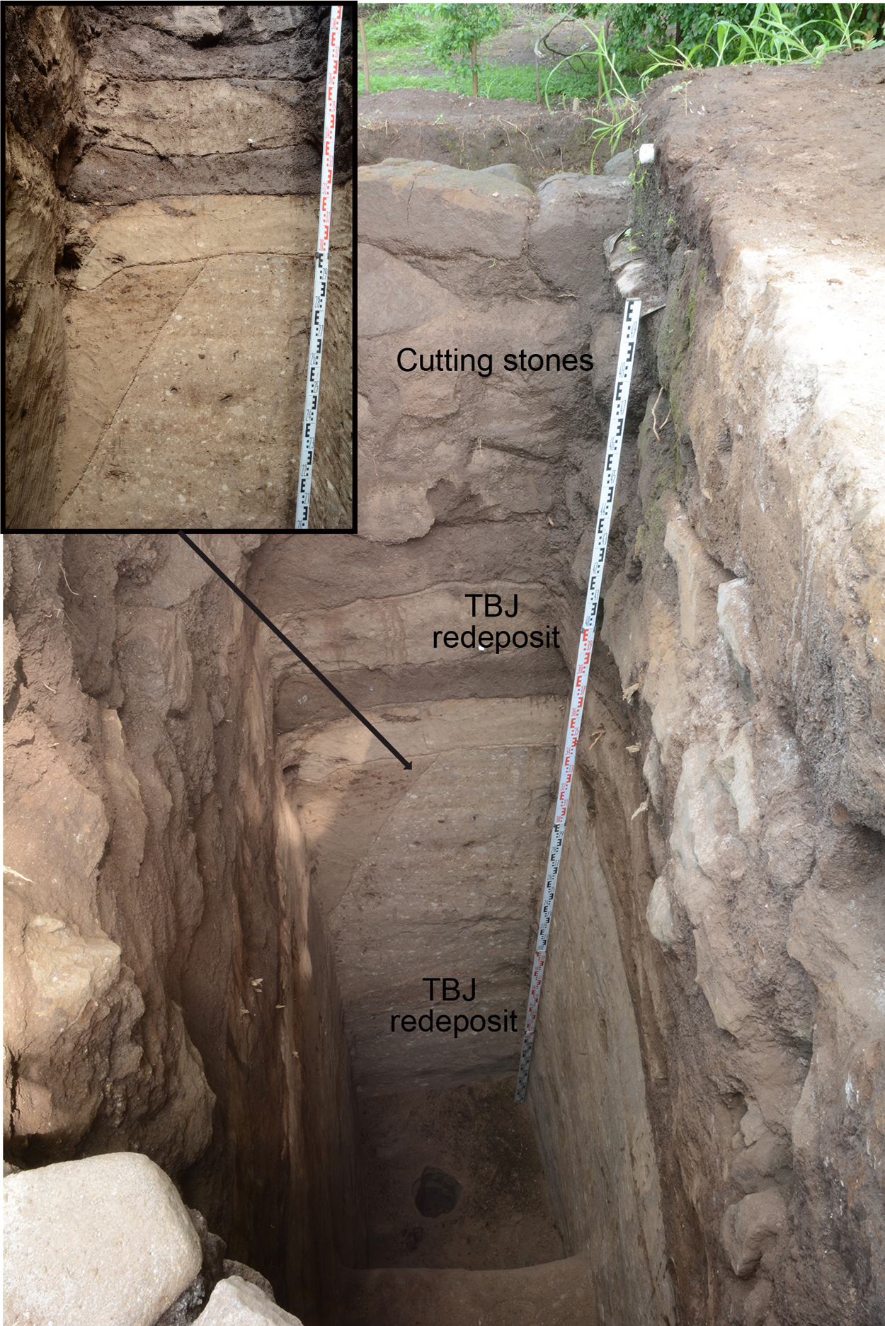
Figure 4. Large amount of the TBJ tephra redeposited found at Tr.5. (Photographs by Akira Ichikawa.)
The subsequent building was constructed of an approximately 5 m thick TBJ redeposit faced by cut-stone blocks (Figures 3b, 3c, and 5). The TBJ redeposit had slightly different compositions (Figure 4). For instance, one area consists of only unit VII, whereas another one mixes units II and VII, suggesting the presence of different primary TBJ tephra units. Only four small, scraped slip potsherds (Guazapa group) were recovered from the TBJ redeposit, suggesting that the TBJ redeposit was carefully mixed, deposited, and compacted. The cut-stone blocks included volcanic tuffs and slabs. Their sizes varied (20–70 cm length, 20–50 cm width, and 10–20 cm height), their form was irregular, and cut-stone blocks were placed directly on the TBJ construction fill. These materials are available from the eastern slope of the San Salvador volcanic complex, although further exploration is needed to verify whether this actually was the source. The TBJ and stone-faced phase architecture were used to build a platform measuring approximately 80 × 55 m and 6 m high (Figure 3b). Based on the architectural features, the platform's volume is at least 24,000 m3, accounting for approximately 75% of the Campana Structure's volume. The platform had four terraces and a central staircase on its west side that is 16 m wide (Figures 3b, 3c, and 6).
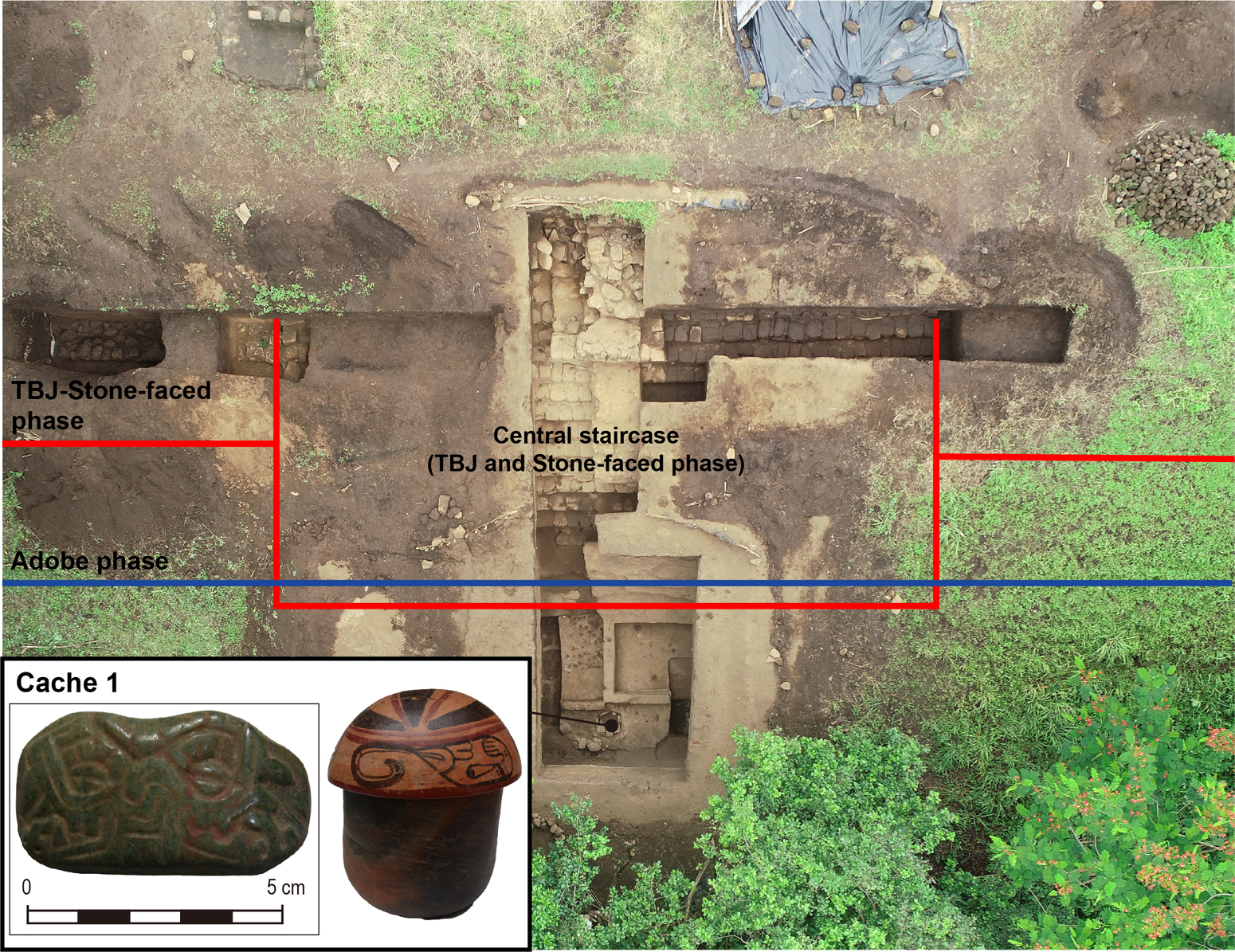
Figure 5. Central staircase of TBJ stone-faced phase, adobe phase, and cache 1 at the Campana Structure. (Photographs by Akira Ichikawa.)
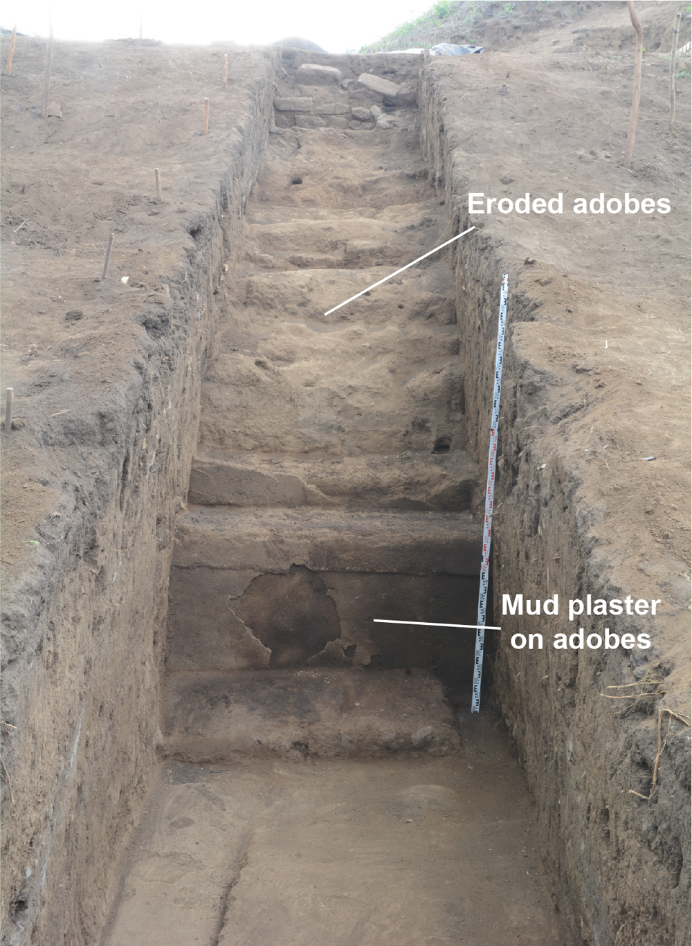
Figure 6. First terrace of adobe construction phase coating by mud plaster. (Photograph by Akira Ichikawa.)
Notably, the TBJ and stone-faced construction described in the previous paragraph is located under the LC tephra. The primary LC tephra recorded in the Campana Structure was approximately 25 cm thick. According to the Cerén sequence (Miller Reference Miller and Sheets2002:21), these units correspond to units 3 and 4. This stratigraphic relation indicates that the TBJ and stone-faced phase of the Campana Structure must have been contemporaneous with Cerén. Excavation data from elsewhere at San Andrés have as yet failed to uncover other monumental structures dating to the period between the TBJ and LC eruptions.
After the LC eruption, a large-scale monumental public construction project was initiated at San Andrés. Architectural materials, techniques, styles, and probably labor organization substantially changed. Buildings were constructed using adobe bricks and mud plaster (except for Structure 7, which was made of large cut-stone blocks); TBJ tephra was no longer used as a construction material (Supplemental Figure 1). The Campana Structure platform was expanded to approximately 85 × 65 m and 7 m in height (Figure 3b). Excavations also encountered ritual offerings associated with the adobe construction phase, most likely deposited during the initial construction stage, such as an offering in a slab-lined pit on the platform's centerline (Figure 3b). Offerings included two vessels, one containing a jade-carved double-headed serpent; another incomplete jade artifact; two Spondylus shells; and a stone ball with red pigment (Figure 5).
The size of the adobe at San Andrés varied from 46 to 64 cm in length, 25 to 35 cm in width, and 15 to 18 cm in thickness (Ichikawa and Rodas Reference Ichikawa and Rodas2020). Furthermore, different colors and textures could indicate that the recipe for making the adobes varied. The mud plaster (average thickness, 5 cm) was composed of roughly 60% black or brown lapilli, measuring 5–15 mm, and silty clay. Ceramics recovered from adobe construction fill are mainly of the Guazapa group but also include several polychromes such as Copador, Gualpopa, and Campana ceramics, time indicators of the Late Classic period in western-central El Salvador (Sharer Reference Sharer1978).
The excavation data provide information about the collapse of the Late Classic monumental core of San Andrés. Only the Campana Structure platform's first terrace was well preserved, and layers between the floor and the El Boquerón (EB) tephra, which is 0.5–1.0 m thick, include collapse debris. Other excavated areas in San Andrés also indicate that layers between the EB tephra and the final phase of construction include collapse debris. such as adobes and mud plasters (Camacho and Díaz Reference Camacho, Díaz, Arroyo, Salinas and Paiz2015). This suggests that the Late Classic monumental core of San Andrés was highly eroded long before the eruption (Figure 6).
Architectural and stratigraphic data show that the monumental core of San Andrés was reoccupied during the Early Postclassic, maybe a few centuries after the Late Classic abandonment, and after the EB eruption. The Mound B platform, located west of the Campana Structure, rests on the EB tephra (Card Reference Card, Begley, Gallardo, Card, Wilson, Brown and Herrmann1997:53). Further, approximately 5 cm of black soil was recorded between the platform's basal part and the EB tephra (Card Reference Card, Begley, Gallardo, Card, Wilson, Brown and Herrmann1997:53). This black soil located between the EB tephra and subsequent construction was also confirmed in the Acropolis (Amaroli Reference Amaroli2015:255). This indicates a time lapse between these two events. Mound B, measuring approximately 25 × 15 m and at least 1.4 m in height, is constructed with volcanic tuff locally known as talpetate. The characteristics, sizes, and forms of these volcanic tuff blocks differ from those used for the TBJ and stone-faced phases of the Campana Structure. The Mound B talpetate blocks are porous; their size and form are fairly standardized and rectangular, measuring 40 × 25 × 20 cm. The blocks were observed in the pyramidal structure on the Campana Structure platform and the Acropolis. The ones used for the Campana Structure are interpreted as evidence of reconstruction during the prehispanic period, because they were placed on top of the original adobe and mud-plastered finish that had eroded substantially (Card Reference Card, Begley, Gallardo, Card, Wilson, Brown and Herrmann1997:42). Mixteca-Puebla-style potsherds were recovered only above the EB deposit, suggesting that Pipil migrants or local groups influenced by Central Mexican traditions may have occupied the area after the EB eruption.
These excavation data significantly enhance our understanding of the rise, development, and fall of San Andrés. The results of 26 radiocarbon dates from this and other Zapotitán Valley sites presented in the next section further enhance our understanding of these events.
Radiocarbon Dates
The Bayesian analysis results are shown in Figures 7 and 8 and the OxCal code in Supplemental Text 1. The final Bayesian model produced in OxCal has both a good model agreement index value (A moldel = 88.7%) and individual agreement value (A overall = 86.5%).

Figure 7. Bayesian model for San Andrés chronology.

Figure 8. Bayesian model for sites in the Zapotitán Valley.
The Bayesian model indicates that the TBJ eruption may be dated to around AD 539–540 and the TBJ-earth construction phase to around AD 545–570. Although these carbon samples may be extracted from old contexts, the model suggests that the TBJ-earth construction phase building project began within decades of the TBJ eruption. The TBJ and stone-faced construction phase are dated to approximately AD 570–620. These carbon samples were dated to after the 14C calibration curve plateau (1600–1550 yr BP), indicating they were clearly from after the TBJ eruption. Bayesian modeling indicated that the LC eruption was plausibly around AD 620. These data imply that a monumental building project and its renovation occurred within a few decades—within a maximum of 80 years—after the TBJ eruption. The adobe phase of construction is dated to AD 625–800. El Cambio and Nuevo Lourdes Poniente correspond to this period. Carbon samples from layers between the final floor level and the EB tephra are dated to approximately AD 900–1050. Evidence of considerable erosion of the Campana Structure and no further building renovation in this period indicates decline or abandonment of the site. Unfortunately, estimates for the date of the EB eruption range widely, from AD 1050 to 1250, and will need to be revised in the future to obtain a more accurate estimate.
Discussion
TBJ Eruption
New excavation and radiometric data suggest that San Andrés was a small village dedicated to ceramic production and agriculture during the Late/Terminal Preclassic period. In the first portion of the Early Classic period before the TBJ eruption, social activities at San Andrés probably declined, as suggested by the low quantities of Early Classic ceramics. The relatively larger quantities of such ceramics found in other sites, such as Nuevo Lourdes Poniente and El Cambio, suggest they may have been of greater importance and also that Early Classic settlement may have been more scattered than previously thought. It is important to note that Guazapa, and Chilanga ceramics, usually found in the context above the TBJ tephra (Sharer Reference Sharer1978), began to be produced before the TBJ eruption in the Zapotitán Valley.
The Bayesian model using available data suggests an approximate date of AD 539–540 for the TBJ eruption. However, more data are needed to verify this model, so the alternative estimate of AD 431 (Smith et al. Reference Smith, Costa, Aguirre-Díaz, Pedrazzi, Scifo, Plunkett, Poret, Tournigand, Miles, Dee, McConnell, Sunyé-Puchol, Harris, Sigl, Pilcher, Chellman and Gutiérrez2020) should not be discarded. Although the TBJ eruption's magnitude could have been catastrophic, it is unlikely that existing societies in the Zapotitán Valley were completely wiped out, as previously proposed (Dull et al. Reference Dull, Southon, Kutterolf, Anchukaitis, Freundt, Wahl, Sheets, Amaroli, Hernandez, Wiemann and Oppenheimer2019; Pedrazzi et al. Reference Pedrazzi, Sunye-Puchol, Aguirre-Díaz, Costa, Smith, Poret, Dávila-Harris, Miggins, Hernández and Gutiérrez2019; Sheets Reference Sheets, Rose, Bommer, López, Carr and Major2004, Reference Sheets, Cooper and Sheets2012). Excavations and radiometric dates suggest the TBJ-earth architecture was built in AD 545–570 and, subsequently, the TBJ and stone-faced architecture in AD 570–620. This is significant because it demonstrates that monumental architecture was constructed earlier than the mid-seventh century, as argued by Dull and coworkers (Reference Dull, Southon, Kutterolf, Anchukaitis, Freundt, Wahl, Sheets, Amaroli, Hernandez, Wiemann and Oppenheimer2019). In addition, as Dull and colleagues estimated (Reference Dull, Southon, Kutterolf, Anchukaitis, Freundt, Wahl, Sheets, Amaroli, Hernandez, Wiemann and Oppenheimer2019:14), if the Zapotitán Valley population had drastically decreased, limited numbers of people would have been available to construct the structure. This would mean that people reoccupied San Andrés and were cooperating to build monumental architecture within a remarkably quick 30 years or, at the latest, 80 years after the eruption if the AD 539–540 date were accepted. Even if the date of AD 431 proposed by Smith and colleagues (Reference Smith, Costa, Aguirre-Díaz, Pedrazzi, Scifo, Plunkett, Poret, Tournigand, Miles, Dee, McConnell, Sunyé-Puchol, Harris, Sigl, Pilcher, Chellman and Gutiérrez2020) is correct, the site was still reoccupied within around 120 years of the eruption or even earlier, as indicated by the significant continuity of ceramic groups such as the dominant utilitarian Guazapa ceramic group.
Furthermore, these results give us reason to question previous theories about the identities of the valley's Late Classic populations. It has been proposed, based on material and architectural similarity, that the first reoccupants of the Zapotitán Valley after the TBJ eruption were Ch'orti’ immigrants from the Copan Valley (Sheets Reference Sheets, Metz, McNeil and Hull2009). However, the Guazapa ceramic group, the dominant utilitarian vessel in Cerén and other Zapotitán Valley sites, existed before the TBJ eruption and continued to be used after the eruption, and other significant ceramic continuities exist between contexts above and below TBJ deposits. Thus, the impact of the eruption in the Zapotitan Valley may not have been as severe as once thought; some local populations may have survived there. Alternatively, descendants of pre-TBJ populations may have first evacuated and then later reoccupied their homeland. Additional research is required to explore these scenarios more rigorously.
This work also highlights the use and reuse of volcanic material as a construction material. The use of considerable amounts of TBJ tephra for the Campana Structure's monumental architecture may have had important practical and symbolic implications. The presence of volcanic fumes, fires, a landscape completely covered with white volcanic ash, and (in all likelihood) frequent earth tremors would have had a significant psychological impact on survivors or subsequent colonizers in the region (Dull et al. Reference Dull, Southon, Kutterolf, Anchukaitis, Freundt, Wahl, Sheets, Amaroli, Hernandez, Wiemann and Oppenheimer2019:14). Volcanoes/mountains are deeply embedded in ancient Mesoamerican life (Freidel et al. Reference Freidel, Schele and Parker1993; Joyce Reference Joyce, Alt and Pauketat2020; Plunket and Urñuela Reference Plunket and Uruñuela2008), and the use and reworking of volcanic material by builders may have preserved memories of catastrophic volcanic disasters in the collective memory. The variations in the mixed TBJ redeposit indicate that different workgroups participated in this building project, which would have reinforced a corporate identity among them. However, the practical qualities of TBJ tephra as a construction material must also be mentioned. As Sheets and colleagues (Reference Sheets, Dixon, Lentz, Egan, Halmbacher, Slotten, Herrera and Lamb2015:354) point out, the TBJ tephra has excellent compaction properties and is still used for construction today. Likewise, variations in the TBJ redeposit were also observed in Cerén, suggesting different workgroups or building episodes (Sheets et al. Reference Sheets, Dixon, Lentz, Egan, Halmbacher, Slotten, Herrera and Lamb2015:355).
Cerén and San Andrés
The new stratigraphic data from San Andrés raise questions about the relationship between Cerén and San Andrés. It has been assumed that San Andrés's elite rulers controlled the political and economic aspects of the valley when the Cerén village existed (Sheets Reference Sheets, Metz, McNeil and Hull2009). However, excavation data suggest that the Acropolis, the North Plaza (possibly a marketplace), eccentric flint, and other rich ritual offerings in San Andrés correspond to the post-LC eruption context. Previous research at the Acropolis indicated that it comprises several architectural units made entirely of adobe and mud plaster (Amaroli Reference Amaroli2015; Boggs Reference Boggs1943; Dimick Reference Dimick1941). The only structure as yet identified as contemporary with Ceren is the Campana Structure's TBJ and stone-faced phase. Furthermore, the archaeological material recovered from the context of the LC and TBJ eruptions is very limited. This suggests that when Cerén existed, San Andrés may have been a focal point of the materialized memory of previous catastrophic eruptions and had a regional community identity as a symbol of the post-TBJ eruption recovery process. It is, however, far from clear that San Andrés was a political or economic center by this time. Cerén commoners may have had greater autonomy than once proposed to develop connections with other distant primary centers such as Chalchuapa and Copan.
San Andrés's Apogee: Loma Caldera Eruption
After the LC eruption, around AD 620, San Andrés became the Zapotitán Valley's primary religious, political, and economic center. The eruption, earthquakes, and villages buried in volcanic tephra must have had a strong psychological impact on the people in the valley. However, the environmental impact was less than that of the TBJ eruption; a large cultural disjuncture did not occur (Sheets Reference Sheets, Grattan and Torrence2008:79), and the population increased by 40,000–100,000 (Black Reference Black and Sheets1983). The use of TBJ tephra and stone-facing techniques was discontinued. Instead, monumental public constructions were constructed with adobe and mud plaster. Adobe production existed before the LC eruption in Cerén, but at that time these adobes were probably property intersection markers (Sheets et al. Reference Sheets, Lentz, Piperno, Jones, Dixon, Maloof and Hood2012:265, 271) and not used for construction. Mud-plastering techniques also existed prior to the LC eruption in limited contexts such as hardened floors.
Adobe and mud-plaster techniques were exclusively used for monumental public buildings in the valley after the LC eruption. Large amounts of adobe blocks indicate that San Andrés was a locus of significant labor investment. In addition, different adobe sizes and materials suggest that different adobe artisans in the valley gathered at San Andrés to construct monumental public buildings (Ichikawa and Rodas Reference Ichikawa and Rodas2020). The quality of the mud-plastering techniques was enhanced using black lapilli, whose inclusion seems to have been inspired by the LC tephra, which contains large amounts of lapilli units. This use of a new material produced as a result of the volcanic eruption may have been for both religious and practical reasons.
During the construction of the Campana Structure and the Acropolis, multiple audiences could have shared ritual practices, as evidenced by human sacrifices, several offering vessels, ceramic incense burners, and carved sculptures of serpents, a parrot, a frog, and a human figure (Boggs Reference Boggs1943). These practices could have contributed to forming local identities and, simultaneously, formalizing social inequality and the centralization of regional political authority. With restricted access and limited visibility from outside the Acropolis, the Acropolis plaza was probably used for elite rituals, suggesting that political power became more exclusive than previously (Boggs Reference Boggs1943).
However, the political system centered at San Andrés had likely disintegrated by AD 800, long before the subsequent EB eruption. No radiocarbon samples from adobe structures from after AD 800 have been run. Furthermore, the layers between the final level of the mud-plastered floor and the EB tephra recorded in the Campana Structure and the Acropolis have a maximum thickness of 1 m; they consistently contain a considerable amount of collapsed debris, suggesting that the monumental core of San Andrés was highly eroded by the time of the EB eruption. In addition, there is evidence that the terminal phase of the Acropolis may have been burned (Amaroli Reference Amaroli2015:265). Thus, the EB eruption was clearly not responsible for the abandonment of the ceremonial core at San Andrés. Other suggested causes are the arrival of immigrants from Central Mexico (though clear evidence of that only appears after the EB eruption) or a decline due to internal problems (though this last is purely speculative)
El Boquerón Eruption
Bayesian modeling estimated the EB eruption date as AD 1050–1250. The layers between the EB tephra and the talpetate block construction in Mound B and the Acropolis suggest that reoccupation of San Andrés's monumental core may have occurred several decades after the EB eruption. This is because the compactness and hardness of the tephra would have damaged agriculture (Sheets Reference Sheets, Rose, Bommer, López, Carr and Major2004:116). The timing of the Late Classic decline, the recovery of agricultural fields, and the lack of Late Postclassic material suggest the eruption presumably occurred around AD 1050 or earlier, as indicated by Ferrés and colleagues (Reference Ferrés, Granados, Hernández, Pullinger, Chávez, Taracena and Dinarte2011). Although a recent study based on the isopach map suggests that 21,000–54,000 people were affected by the eruption, demographic recoveries from the EB eruption occurred a few decades later with no cultural disjuncture (Sheets Reference Sheets, Rose, Bommer, López, Carr and Major2004:117).
However, after the EB eruption, migrants or a new group influenced by Central Mexican traditions may have occupied San Andrés, renovating monumental architecture built a few centuries before, including the Campana Structure and Acropolis. New occupants used talpetate blocks, which were not available before the eruption (Begley et al. Reference Begley, Roberto Gallardo, Alex Wilson and Hermann1997:103), to repair and reuse these earlier structures, treating earlier sacred spaces with reverence. Although it is not certain whether the new builders, who probably were migrants or members of new groups influenced by Central Mexican traditions, witnessed the EB eruption, they might have conceived the innovative use of talpetate blocks, products of the EB eruption, and reconstructed old sacred spaces.
Conclusions
New excavation and radiocarbon data significantly clarify the development, rise, and decline of San Andrés and the impacts of volcanic eruptions on its settlement history and culture. These data suggest that populations in San Andrés were affected and possibly displaced multiple times by volcanic eruptions, yet resilient populations quickly reoccupied and rebuilt the site in the decades after these eruptions. These periods of renewal led to novel architectural—and, likely by extension—social, and ritual practices at the site. As several scholars argue (Hoffman Reference Hoffman, Oliver-Smith and Hoffman1999; Oliver-Smith Reference Oliver-Smith1996; Torrence Reference Torrence2019), the data suggest that abrupt environmental changes caused by volcanic eruptions, especially the TBJ and LC eruptions, were opportunities for local leaders to create new communal affiliations and regional-scale corporate identities, rather than resulting in periods of total societal collapse. These periods of centralization are evidenced by the monumental public building projects, requiring large amounts of labor, which seem to have been rapidly organized after each eruption. The EB eruption was not responsible for the Late Classic collapse of San Andrés, and its timing and impacts need to be investigated further. The new occupants seemed to have been inspired by the volcanic products that covered the valley and, using this material, reconstructed old sacred spaces. The principal factor in the choice of construction materials is often its environmental availability (Blake Reference Blake, Lee and Hayden1988:36). During different eruption periods in the Zapotitán Valley, as in the Mediterranean (Chester et al. Reference Chester, Duncan, Guest, Balmuth, Chester and Johnston2005), people used new innovative construction materials, volcanic products, and methods of labor organization to construct monumental architecture as a social response to eruptions. This use of volcanic products as construction material embraced a religious/symbolic meaning, as well as a practical use.
Obtaining more radiocarbon dates from secure contexts and combining them with other archaeological evidence are required to advance this research. Using Bayesian modeling, this study prefers the AD 539–540 for the TBJ eruption, but the possibility of the AD 431 eruption date should not be discarded (Smith et al. Reference Smith, Costa, Aguirre-Díaz, Pedrazzi, Scifo, Plunkett, Poret, Tournigand, Miles, Dee, McConnell, Sunyé-Puchol, Harris, Sigl, Pilcher, Chellman and Gutiérrez2020). If the earlier date is correct, the social response in the Zapotitan Valley was initiated earlier than the assumption proposed here, and the recovery process was slower or more gradual rather than drastic. To advance the discussion, data from Chalchuapa, Cara Sucia, and Quelepa—regional primary centers affected by the TBJ eruption—should be included. Recent discussions have focused only on eruption dates. However, discussions based on archaeological evidence alone are insufficient due to the lack of archaeological investigations focusing on the TBJ eruption. Further AMS radiocarbon dating is also needed to date the LC eruption. This study argues that the EB eruption did not cause the Late Classic abandonment or social change during the Early Postclassic period. Nevertheless, further data will be needed to develop a similar discussion for other eruptions.
The data presented here and future research in San Andrés will provide useful information for reimagining southeastern Mesoamerica's social dynamics and human responses to volcanic eruptions. Further investigation at San Andrés will enhance our understanding of the political and economic dynamics at Cerén and give a broader understanding of the degree and extent of the power of the Copan dynasty in El Salvador and southeastern Mesoamerica.
Acknowledgments
I am grateful to the Dirección de Arqueología de la Dirección Nacional de Patrimonio Cultural, Ministerio de Cultura, El Salvador; Nagoya University; and the University of Colorado Boulder for their invaluable support. This research was supported by grants from the JSPS KAKENHI (#26101003, 19H05734, and 19K13400), Mitsubishi Foundation, and Inamori Foundation in Japan. I also gratefully acknowledge helpful feedback on early drafts of this article and encouragement from Arthur Joyce, Payson Sheets, Erlend Johnson, and Shigeru Kitamura. Finally, I thank the three anonymous reviewers for their insightful comments that improved this article.
Data Availability Statement
The excavated materials are available in the Dirección de Arqueología de la Dirección Nacional de Patrimonio Cultural, Ministerio de Cultura, El Salvador. All digital and analysis data were generated by the author and are available for research purposes by contacting him.
Supplemental Material
To view supplemental material for this article, please visit https://doi.org/10.1017/laq.2021.28.
Supplemental Figure 1. Matrix indicating the stratigraphic relations and radiocarbon samples.
Supplemental Table 1. Radiocarbon dates from San Andrés.
Supplemental Table 2. Radiocarbon dates from sites in the Zapotitán Valley.
Supplemental Text 1. OxCal code (OxCal v.4.4.2).


 Open access