


Introduction
The play type concept is relatively new in geothermal exploration and aims to cluster geothermal resources into groups, which share similar geological conditions (Moeck, Reference Moeck2014). The term ‘play’ is much older and appeared for the first time in publications in the 1930s, with the description of petroleum geology as a new specific discipline in hydrocarbon exploration (Lahee, Reference Lahee1933). In the 1960s, the play concept evolved into a practical approach by the developing petroleum industry for the assessment of hydrocarbon resources, although the term ‘play’ was never clearly defined (Doust, Reference Doust2010). Common to all existing play concepts is that the play describes groups of commodities and prospects that closely resemble each other geologically. While hydrocarbon resources are grouped into clusters that share similar source, reservoir, seal and trap conditions (Doust, Reference Doust2010), geothermal resources are grouped into clusters with similar heat transport mechanisms and geological controls on permeability and porosity (Moeck, Reference Moeck2014).
At geosystem scale, geothermal plays can be broadly separated into two types related to the mechanism by which heat is transported into the reservoir: the heat transport is dominated by either convection or conduction. Whether convection or conduction dominates depends primarily on the characteristics of the heat source and the distribution and range of permeability within the host rocks at the system scale (Smith & Chapman, Reference Smith and Chapman1983; Lawless et al., Reference Lawless, White, Bogie and Andrews1995; López & Smith, Reference López and Smith1995, Reference López and Smith1996; Bogie et al., Reference Bogie, Lawless, Rychagov, Belousov and Rychagov2005; Zech et al., Reference Zech, Zehner, Kolditz and Attinger2016). It is important to recognise that convection and conduction are end-members of a heat transfer continuum. Conductive intervals always exist in localised parts of a convective regime (frequently, for example, on the outer margins of convective systems) while minor convective intervals can sometimes exist within conductive systems. For example, gravity-driven convection (i.e. forced convection) might occur within a discrete aquifer within a conduction-dominated system in steep mountainous terrain where recharge zones are at a higher elevation than discharge sites (Deming, Reference Deming1992, Reference Deming1994; Deming et al., Reference Deming, Sass, Lachenbruch and De Rito1992; Tóth, Reference Tóth2009). Alternatively, buoyancy variations due to different concentrations of fluid salinity can result in local convection (i.e. free convection) within sedimentary aquifers.
Interestingly, the hydrocarbon industry has recently refocused on play-based exploration and returned to exploration approaches of the 1990s (Shoup, Reference Shoup2018). Play-based exploration involves understanding all elements of a petroleum system for a given play and examines how and where those elements come together. In the style of play-based exploration of hydrocarbon resources, the assessment process starts with the geosystem-scale basin focus, followed by the regional-scale play focus and finally the local-scale prospect focus (Royal Dutch Shell, 2013). The geosystem scale focuses on large-scale elements such as plate setting, tectonostratigraphic framework and geologic evolution to determine sedimentary fill, stratigraphic sequences and the potential for generating reservoirs and commodities. The play scale focuses on regional-scale understanding of the petroleum system and leads to the identification, mapping and quantification of plays. The local-scale prospect focus is concerned with seismic evaluation, confidence assessment for a range of geological models and drilling selection. In the play-based exploration guide of Royal Dutch Shell (2013), petroleum plays are subdivided and concretised in play segments, play elements and play levels. These subdivisions are required for the play identification workflow. To be precise, a play level is a stratigraphic megasequence and captures play segments; a play segment is a subdivision of a play, field and prospect that share common geological controls within a play level and entrap play segments; a play element is a significant stratigraphic change as major bounding seals or changing depositional environment result in a different facies.
The geothermal industry, developers or agencies can benefit from these renewed attempts in play-based exploration by adopting and modifying approaches to describe, define and evaluate play types. The global application of the geothermal play type concept was successful and resulted in just three play types, with over 90% of the world’s geothermal generation associated with convection-dominated magmatic/plutonic plays (Moeck et al., Reference Moeck, Beardsmore and Harvey2015). However, the application of the existing geothermal play type catalogue to cluster geothermal resources of a whole country involving crustal permeability for play characterisation is lacking.
This article presents the first geothermal play cluster of Germany and new terms for play-based geothermal exploration such as play level and play element, required for an ongoing categorisation of geothermal play types. The focus is on the depth relation of the porosity – permeability/transmissivity variation, and compiles data from the geothermal prospects in the Molasse Basin. New data interpretation of the deep well Gerestried, drilled in 2017 south of Munich, is integrated into this study and presented for the first time in a geothermal play context.
Geothermal installations in Germany
The majority of geothermal projects worldwide are located in geological systems with convection-dominated heat transport such as magmatic arcs or large-scale active faults (e.g. plate boundaries) (Moeck, Reference Moeck2014). Germany, with its conduction-dominated heat transport systems, lacks natural steam reservoirs, which are functional for a direct drive of turbines.
Thus, geothermal power generation in Germany operates with binary systems, which use a working fluid in a secondary cycle (ORC or Kalina cycle). At the end of 2018, nine geothermal plants with an installed capacity of about 38 MWel fed electricity into the German grid. However, the necessary implementation of the heat transition (referred to as Wärmewende) in Germany shifts the focus to geothermal heat production. In contrast to fossil fuels, geothermal heat in place is usable over a large depth and temperature range by a whole variety of technologies. Due to this scalability of geothermal applications and the perpetual heat demand, there is an enduring potential for the development of geothermal utilisation (e.g. Stober & Bucher, Reference Stober and Bucher2013).
In Germany, common deep geothermal utilisations for direct use are district heating plants or combined heat and power (CHP) plants, thermal spas and space heating. At one prospect (Kirchweidach/Bavaria), a greenhouse is heated by geothermal energy to substitute fossil fuels. Presently, about 190 operating geothermal installations are connected to reservoirs in a depth range between 400 and 5000 m (Figure 1). Geothermal well doublets comprising a production and an injection well are typically used for district heating, whereas spas only need a single well to cover the heat and water demand. Furthermore, five medium-deep to deep borehole heat exchangers are in operation in Germany. In addition, the use of mine water is becoming more and more interesting with regard to the heat transition in Germany (Bussmann et al., Reference Bussmann, Appelhans, Hahn, Jagert, Bracke, Seidel and König2019).

Figure 1. Sites of deep geothermal utilisation in Germany and neighbouring countries. The background colours represent predicted temperature ranges of the deepest identified geothermal resources in sedimentary or volcanic rocks respectively (map generated in GeotIS, 2019).
The geothermal installed capacity of direct heat-use applications shows a considerable increase from 157.8 MWth in 2010 to 336.1 MWth in 2015 and reached 406.3 MWth in 2018 (Agemar et al., Reference Agemar, Weber and Schulz2014; GeotIS, 2019). The 29 district heating and CHP plants account for the largest portion of the geothermal capacity with about 346.2 MWth. Due to favourable geological conditions, geothermal district heating and power plants are primarily located in the Molasse Basin in southern Germany, and subordinately in the North German Basin or along the Upper Rhine Graben (Agemar et al., Reference Agemar, Schellschmidt and Schulz2012, Reference Agemar, Weber and Schulz2014).
In addition to installations using geothermal energy from a greater depth range between 400 and 5000 m, numerous small- and medium-sized decentralised geothermal heat pump units are in use for heating and cooling of individual houses and office buildings. At the end of 2018, more than 380,000 geothermal heat pumps were running successfully in Germany, supplying renewable heat mostly for residential buildings. At the end of 2018, installed geothermal heat pumps have reached a thermal output of about 4400 MWth in total (Weber et al., Reference Weber, Born and Moeck2019).
Besides supporting research and development projects, the German federal government incentivises new projects by a feed-in tariff for geothermal electricity under the Renewable Energy Sources Act (EEG). Since summer 2014, the revised EEG grants a subsidy of €0.25 kWh−1 for geothermal electricity generation. For a couple of years now, the German government has provided a grant for new heating technologies by the market stimulation programme (MAP). In 2015, very good conditions were established for the installation of geothermal heat pumps. The minimum grant for geothermal heat pumps was raised to €4,000 and can be over €7,000. The better conditions led to an increase in the number of subsidised heat pump units.
Crustal permeability and geothermal play types
The heat transport mechanisms by either conduction (i.e. heat flow), advection or convection (i.e. coupled heat and fluid flow) are directly related to porosity and permeability, whereby convection can be driven by thermal and chemical gradients (i.e. free convection) and convection/advection by hydraulic gradients induced by topography-driven groundwater flow (i.e. forced convection) (Smith & Chapman, Reference Smith and Chapman1983; Woodbury & Smith, Reference Woodbury and Smith1985; López & Smith, Reference López and Smith1995, Reference López and Smith1996; Tóth, Reference Tóth2009). Moreover, the bulk porosity strongly influences rock thermal conductivity as shown by different types of conversion equations (or mixing models) required to calculate in situ thermal conductivity from laboratory thermal conductivity values (Brigaud et al., Reference Brigaud, Chapman and Le Douaran1990; Vasseur et al., Reference Vasseur, Brigaud and Demongodin1995; Fuchs et al., Reference Fuchs, Schütz, Förster and Förster2013; Albert et al., Reference Albert, Schulze, Franz, Koenigsdorff and Zosseder2017). The permeability is directly related to the ability of rock to channel fluids, which are the heat transport medium in convection- or advection-dominated plays. Porosity and permeability are therefore the most important play properties to characterise and delineate geothermal plays hosting recoverable resources. The spatial variations of porosity and permeability are important to understand for sustainable geothermal reservoir operation (Homuth et al., Reference Homuth, Götz and Sass2014). They are linked to the geologic criteria used to group and characterise geothermal plays by structures such as faults and fractures or processes such as tectonism, compaction and diagenesis (Moeck, Reference Moeck2014). All these and other processes may create, increase or reduce porosity and static permeability.
The permeability of rock is not only relevant to group geothermal plays but also governs the decision of applied geothermal technology. Low permeable or tight reservoirs need to be enhanced by reservoir stimulation to create enhanced geothermal systems (EGS) while high permeable reservoirs can serve for direct use referred to as hydrothermal systems. Moeck (Reference Moeck2014) grouped conduction-dominated plays into EGS petrothermal, EGS hydrothermal and hydrothermal plays based on the ratio between porosity and permeability. Depth has a physically and geologically meaningful influence on the ratio of porosity and permeability (Mountjoy et al., Reference Mountjoy, Drivet and Marquez2001). The permeability of clastic sediments in the cool uppermost crust (0–2000 m depth) is often well constrained by a function of mechanical compaction (e.g. Daigle & Screaton, Reference Daigle, Screaton, Gleeson and Ingebritsen2016; Luijendijk & Gleeson, Reference Luijendijk, Gleeson, Gleeson and Ingebritsen2016). However, the predictability for porosity–permeability relations diminishes at depths where diagenesis becomes important (Mountjoy et al., Reference Mountjoy, Drivet and Marquez2001). In conduction-dominated geothermal play types, the depth range between 2000 and 5000 m is the most relevant for district heating or binary (CHP) plants. In regions like Europe or North America, where sedimentary systems in the subsurface come together with a high heat demand at the surface, the crustal permeability structure at 2–5 km depth will obviously be of increasing interest for geothermal applications (e.g. Tester et al., Reference Tester, Anderson, Batchelor, Blackwell, DiPippo, Drake, Garnish, Livesay, Moore, Nichols, Petty, Toksöz, Veatch, Baria, Augustine, Murphy, Negraru and Richards2006; Weydt et al., Reference Weydt, Heldmann, Machel and Sass2018).
In Germany, the geothermal development is most pronounced in the Molasse Basin, the German part of the North Alpine foreland basin (Bachmann et al., Reference Bachmann, Müller and Weggen1987; Bachmann & Müller, Reference Bachmann and Müller1992). The utilised reservoir rock is an Upper Jurassic carbonate sequence, also known as the ‘Malm’ formation (Meyer & Schmidt-Kaler, Reference Meyer and Schmidt-Kaler1990). The typical wedge-shaped geometry of the foreland basin causes a continuous deepening of the ‘Malm’ from north to south (Sinclair & Allen, Reference Sinclair and Allen1992). Consequently, geothermal operation in the Upper Jurassic applies from 800 to nearly 5000 m depth. Thus, the ‘Malm’ is an ideal study formation to investigate the porosity and permeability variations with respect to depth (Birner et al., Reference Birner, Fritzer, Jodocy, Savatis, Schneider and Stober2012), and hence to contribute to the knowledge of upper crustal permeability as claimed by Ingebritsen & Gleeson (Reference Ingebritsen and Gleeson2017).
Clustering geothermal resources of Germany into play types
The application of the generic geothermal play catalogue of Moeck (Reference Moeck2014) for clustering the German geothermal resources results in four different geothermal play types for Germany and adjacent areas (Figure 2). The criterion for this first geothermal play type mapping is – according to the play concept – to group similar geosystems as intracratonic basins or foreland basins, granitic provinces or recent graben systems into geologic analogues. The most common play types are conduction-dominated, with the CD1 – intracratonic basin plays (e.g. North German Basin, Thüringen Basin, Paris Basin) followed by the CD2 – foreland basin (South German Molasse Basin) and orogenic belt play types (e.g. Alpine fold belt, Rhenish Massif), the CD3 – basement rock plays (e.g. Black Forest granitic province, Oberlausitz granitic province) and finally with the only convection-dominated play type, the CV3 – extensional terrain plays (Rhine Graben, Eger Graben) (Figure 2). Local topography-driven groundwater flow in hilly regions, such as in southern Germany the Ohlsbach plume with the discharge of deep ascending saline water (Stober et al., Reference Stober, Richter, Brost and Bucher1999), is not considered in this countrywide investigation.
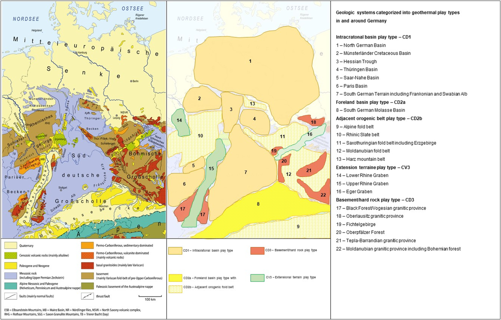
Figure 2. Categorisation of geologic systems into geothermal play types in and around Germany based on play types from Moeck (Reference Moeck2014). Left: Geological map of Germany, serving as basemap for geothermal play type categorisation; right: First geothermal play type map of Germany. Geological map at left side modified from Gretarsson CC-BY-SA 4.0, based on Freudenberger & Schwerd (Reference Freudenberger and Schwerd1996), Pawlewicz et al. (Reference Pawlewicz, Steinshouer and Gautier2003), Henningsen & Katzung (Reference Henningsen and Katzung2006) and BGR (2008).
Regarding the history of geothermal development in Germany related to geothermal play types, the development started in the North German Basin as an intracratonic basin play type, overleapt and tremendously increased in a foreland basin play type, while the highest geothermal potential is in a convection-dominated extensional terrain play type. Specifically, the first geothermal heating plant Waren (Müritz) was installed in 1986 in the North German Basin, a CD1 – intracratonic basin play type. The highest geothermal gradient exists in the Upper Rhine Graben (Freymark et al., Reference Freymark, Sippel, Scheck-Wenderoth, Bär, Stiller, Fritsche and Kracht2017), a convection-dominated CV3 – extensional terrain play type. The present-day vast geothermal development with the largest number of installed geothermal well doublets is situated in a CD2 – foreland basin play type, namely the Molasse Basin (Agemar & Tribbensee, Reference Agemar and Tribbensee2018), where Upper Jurassic carbonate rocks are used as geothermal reservoir.
Focusing on the Molasse Basin as a case study for detailed play typing, it is evident that more than one geological formation or stratigraphic unit can be geothermally utilised in a geothermal play type, implying that a play type consists of different play levels. Following the play-based exploration concept of the hydrocarbon industry, the Molasse Basin is subdivided into different sedimentary megasequences, where the Upper Jurassic carbonate rocks represent a passive margin megasequence (Bachmann & Müller, Reference Bachmann and Müller1992; Roeder & Bachmann, Reference Roeder, Bachmann, Ziegler and Hòrvath1996). We therefore consider the Upper Jurassic ‘Malm’ formation as one play level in the Molasse Basin and review the number of existing geothermal wells as play-testing wells. The purpose of this well review is to identify where technical success results in a productive well at a certain formation or play element. The grouping of these play elements is derived from the porosity/permeability ratio compared with depth and carbonate facies, presented in the following sections.
Carbonate reservoirs as play level in foreland basins: example Upper Jurassic of the Molasse Basin
As mentioned above, play-based exploration passes through different scales from geosystem to local prospect scale. When a stratigraphic unit is analysed for exploration, it becomes obvious that the play type at the geosystem scale as hitherto defined by Moeck (Reference Moeck2014) is not precise enough to describe likely reservoirs or promising drilling targets. We suggest, therefore, a scale-dependent play-based geothermal exploration adapted and modified from hydrocarbon play-based exploration (Royal Dutch Shell, 2013). Play-based exploration starts with the geosystem focus where the geological boundary conditions of a geothermal play type are described (Figure 3). The aim of this first step is to sort the geosystem into one of the geothermal play type categories as done in Figure 2. The second step focuses on the identified play and analyses levels and elements to better understand the play, namely the geologic controls on porosity and permeability, and ultimately to delineate exploration targets and prospect areas. In the third step, one play level and one or more play elements are analysed on the prospect scale (Figure 3).

Figure 3. The exploration play pyramid, illustrating the steps of play-based exploration (modified from Royal Dutch Shell, 2013).
The Molasse Basin is one of the best-studied geothermal play types in Germany (GeoMol Team, 2015). There are several stratigraphic units consisting mainly of carbonate or sandstone that could be defined as geothermal plays. From the base to the top, the most important ones are the Upper Muschelkalk carbonates (in SW Germany) and the Upper Jurassic ‘Malm’ carbonates in the Mesozoic (Stober & Villinger, Reference Stober and Villinger1997; Jodocy & Stober, Reference Jodocy and Stober2009; Stober et al., Reference Stober, Jodocy, Burisch and Person2013a; Stober, Reference Stober2014), as well as the Upper Eocene Lithothamnium, Basal Sandstone and Ampfing Sandstone, Lower Oligocene Baustein Beds and Upper Oligocene Chattian Sands in the overlying Tertiary Molasse sediments (Bachmann et al., Reference Bachmann, Müller and Weggen1987; Bachmann & Müller, Reference Bachmann and Müller1992; Fritzer et al., Reference Fritzer, Settles and Dorsch2018). In particular, the Upper Jurassic carbonate reservoir is intensively investigated by 2D seismic, 3D seismic (e.g. Lüschen et al., Reference Lüschen, Dussel, Thomas and Schulz2014; Hartmann et al., Reference Hartmann2017), well log data, hydraulic test data (e.g. Birner et al., Reference Birner, Fritzer, Jodocy, Savatis, Schneider and Stober2012; Stober et al., Reference Stober2014; Dussel et al., Reference Dussel, Lüschen, Thomas, Agemar, Fritzer, Sieblitz, Huber, Birner and Schulz2016), drill core and cutting analysis (Mraz et al., Reference Mraz, Moeck, Bissmann and Hild2018, Reference Mraz, Wolfgramm, Moeck and Thuro2019) and hydrochemistry studies (e.g. Birner et al., Reference Birner, Mayr, Thomas, Schneider, Baumann and Winkler2011; Stober et al., Reference Stober, Jodocy, Burisch and Person2013a, Reference Stober2014; Stober, Reference Stober2014). The geological controls in the Upper Jurassic on the well productivity are still under debate; however, fault system, depositional system as reef and laminated facies, and karst are identified drilling targets. Similar to the definitions for hydrocarbon exploration plays, we define these geological controls on reservoir productivity as play segments (Table 1), while the ‘Malm’ formation as a stratigraphic unit is a play level (Table 1). Besides the primary geologic controls such as deposition or faults, also compaction and diagenesis, and hence episodes of basin subsidence and burial, have a strong effect on reservoir productivity (Drivet & Mountjoy, Reference Drivet and Mountjoy1997; Mountjoy et al., Reference Mountjoy, Drivet and Marquez2001; Mraz et al., Reference Mraz, Wolfgramm, Moeck and Thuro2019). This is especially relevant in foreland basins, where one play level is located at increasing depth towards the orogenic belt (Sinclair & Allen, Reference Sinclair and Allen1992; Mraz et al., Reference Mraz, Moeck, Bissmann and Hild2018). We consider these depth-related different porosity and permeability domains as play elements (Table 1).
Table 1. Definitions of terms required for play-based exploration of geothermal resources

Porosity, permeability, depth ratio of carbonate play
The ratio of porosity to permeability in conduction-dominated geothermal plays is variable, reflecting different grades of compaction, diagenesis and brittle failure proceeding in different types of lithology (Moeck, Reference Moeck2014). Carbonate rock exhibits characteristically vast ranges of permeability and porosity caused by the manifold petrophysical properties and determined by fabric, mud content, facies, fossils and mineralogy (Mraz et al. Reference Mraz, Wolfgramm, Moeck and Thuro2019). In sum, carbonate reservoirs are of heterogeneous and anisotropic nature due to primary factors from biochemical sedimentation in different depositional environments and due to secondary processes such as pressure solution, precipitation, fracture formation and dissolution (karst).
In the Molasse Basin, the porosity of the Upper Jurassic carbonate play varies between << 1% and 17%, with an average of 5% (Koch et al., Reference Koch, Clauser, Jorand, Vogt, Arnold, Mottaghy and Pechnig2009; Böhm, Reference Böhm2012; Birner, Reference Birner2013). The play level Kimmeridge/Tithonian built up by limestone has a porosity range between 0.07% and 17.1%, while the same play level has a porosity range of 1.5 to 6.7% when it is dolomitised (Koch et al., Reference Koch, Clauser, Jorand, Vogt, Arnold, Mottaghy and Pechnig2009; Dussel et al., Reference Dussel, Lüschen, Thomas, Agemar, Fritzer, Sieblitz, Huber, Birner and Schulz2016). Secondary dolomitisation controls porosity and also permeability by interconnected intercrystalline pores, resulting in a permeability range of 3 × 10⁻¹⁷ to 6.3 × 10⁻¹⁴ m2 (Birner et al., Reference Birner, Fritzer, Jodocy, Savatis, Schneider and Stober2012; Birner, Reference Birner2013). Elevated permeability in the order of 10−14 m2 occurs within hypidiomorph to idiomorph dolomitised limestone in the play level Kimmeridge as derived from the completely cored well Moosburg (Birner, Reference Birner2013). Hydraulic tests from several geothermal wells producing from the Upper Jurassic ‘Malm’ formation indicate a fracture-controlled reservoir because a minor part of the inflow derives from intact matrix rock and the major portion of the inflow originates from fracture zones (Birner, Reference Birner2013).
One approach for evaluating carbonate plays is by their ratio of porosity to permeability (Moeck, Reference Moeck2014). In Figure 4, different carbonate reservoirs are compiled, along with categories of play elements such as lithofacies, fractures and karst, and illustrated in a porosity vs permeability diagram with regard to carbonate rock type. Salley (Reference Salley2000) has developed a similar reservoir classification scheme for hydrocarbon resources. Regarding the different play elements of the Upper Jurassic of the Molasse Basin, compared with carbonate formations from the Alberta Basin, which is the same geothermal play type as the Molasse Basin (i.e. a foreland basin), three different carbonate rock types correlate with certain ranges of porosity/permeability ratios (Figure 4): (1) fractured/karstic carbonate with low porosity and high permeability (data in the blue area of Figure 4), (2) vuggy carbonate with high porosity and low permeability (data in the upper green area of Figure 4), and (3) micritic carbonate with low porosity and low permeability (data in the lower green area of Figure 4). The micritic carbonate type is in the same porosity–permeability range as crystalline rock (data in the brown area of Figure 4). The operating geothermal projects in Germany installed in carbonate plays are mostly in fractured/karstic or vuggy play elements. Karstic play elements are hydrothermal systems with high flow rates, as in the example field Unterhaching close to Munich, while vuggy play elements require some acidic stimulation to gain economic well production. These geothermal fields can be considered as EGS hydrothermal, i.e. requiring technologies from Enhanced Geothermal Systems. The micritic play elements plot in the range of the EGS petrothermal system where the porosity/permeability ratio is so low that hydraulic stimulation or proppants are required to generate or keep fractures open. The porosity from the 4.5 to 5 km deep ‘Malm’ formation, derived from cores from the deep geothermal well Geretsried, coincide with the low porosity from cores of the granite at the Soultz geothermal test side (Figure 4); however, the permeability at Gerestried is higher, indicating an only fracture-controlled reservoir.

Figure 4. Porosity and reservoir permeability relation of different carbonate rocks, compared with crystalline rock that represents enhanced geothermal systems. CD2 and CD3 refer to play type indices for conduction-dominated play type labelling in Moeck (Reference Moeck2014). CD2a, c, d, f are Upper Jurassic of the Molasse Basin; CD2b and e are carbonates from the Alberta Basin in Canada. The yellow dots represent carbonates collected in the deep geothermal well Geretsried (Molasse basin). Figure modified from Moeck (Reference Moeck2014).
In addition to the rational comparison of permeability and porosity for carbonate reservoirs, the depth dependency of the transmissivity or hydraulic conductivity may help to delineate the local reservoir performance. Hydraulic parameters of the ‘Malm’ aquifer in the Molasse Basin are described and statistically analysed by Birner et al. (Reference Birner, Fritzer, Jodocy, Savatis, Schneider and Stober2012). For the western part of the Molasse Basin (i.e. the basin part in the federal state of Baden-Württemberg), Stober et al. (Reference Stober, Jodocy, Burisch and Person2013a) compiled and analysed hydraulic conductivities of the Upper Jurassic reservoir, resulting in a good correlation between hydraulic conductivities (T/H; H is the test section of the well derived from production tests). Further to the east, for the central part of the Molasse Basin, Birner et al. (Reference Birner, Fritzer, Jodocy, Savatis, Schneider and Stober2012) calculated and evaluated transmissivities of 1−5 × 10⁻⁴ m2 s−1 (southwest of Munich) to 1−5 × 10⁻³ m2 s−1 (northeast of Munich) from production tests. In recent years, the exploration has gone to deeper areas of the Upper Jurassic carbonate reservoir towards the Alpine frontal fault. Acid stimulation work at the Geretsried site, located c. 40 km south of Munich, was carried out at 4.3 to 4.7 km vertical depth with main inflow zones at 4.4 to 4.5 km along the sidetrack GEN-1ST-A1. The main production test was a nitrogen lift test in a 5 inch tubing with a down-hole shut-in (packer was installed at a depth of 3945 m MD). The nitrogen injection was carried out with a 1¾ inch coiled tubing. A 944 m3 volume of water produced with an average flow rate of 3.6 l s−1. Analysis of the pressure recovery measurements results in a transmissivity of 3.6 × 10⁷ m2 s−1 and a permeability K = 10−16 m2 and reveals a very low transmissivity, two orders lower than the wells in the productive Munich region (Figure 5).

Figure 5. Depth dependency of transmissivity (logarithmic scale) for the Upper Jurassic reservoir in the Munich region (Malm in the depth range between 1500 and 4000 m) compared to the low transmissivity in the deeper part of the basin (>4000 m, sidetrack Geretsried GEN-1ST-A1).
Discussion and conclusion
The geothermal play concept helps to categorise geothermal resources by geological means. After a preliminary review, four different play types are present in Germany and neighbouring countries encompassing 22 geological systems (Figure 2). The geothermal play type catalogue introduced by Moeck (Reference Moeck2014) is applicable to categorise geothermal play types countrywide as our case study with Germany shows, but seems not sufficiently precise to describe geothermal plays on a prospect scale. As an example, the Molasse Basin, representing the geothermal play type foreland basin with conduction-dominated heat transport, has probably more than one geothermal play (Fritzer et al., Reference Fritzer, Settles and Dorsch2018). The most prominent and best-explored geothermal play in the Molasse Basin is the Upper Jurassic formation, built up by carbonate rock. Geothermal exploration results show that faults, depositional facies, karst, diagenesis and dolomitisation control porosity, permeability and hence reservoir productivity (Dussel et al., Reference Dussel, Lüschen, Thomas, Agemar, Fritzer, Sieblitz, Huber, Birner and Schulz2016; Mraz et al., Reference Mraz, Wolfgramm, Moeck and Thuro2019), which has also been shown for carbonates in the Alberta Basin (Drivet & Mountjoy, Reference Drivet and Mountjoy1997; Mountjoy et al., Reference Mountjoy, Drivet and Marquez2001).
Another approach to evaluate conduction-dominated geothermal plays is by the ratio of permeability to depth. Moeck (Reference Moeck2014) introduced the porosity/permeability ratio with regard to reservoir rock type and showed the highest variability of this ratio for carbonate rocks. Depth was not considered in this porosity–permeability comparison. One important aspect in geothermal play typing might therefore be the correlation of permeability or reservoir transmissivity (the permeability related to reservoir thickness) with depth to identify the ideal play level for geothermal production. We therefore correlated the reservoir transmissivity of the Upper Jurassic from 27 geothermal wells to depth (in this case reservoir top) in the Molasse Basin.
The results indicate a transmissivity decrease with depth (Figure 4). Observed data from other parts worldwide confirm a decrease of crustal permeability with depth (e.g. Ingebritsen & Manning, Reference Ingebritsen and Manning1999; Ehrenberg & Nadeau, Reference Ehrenberg and Nadeau2005; Stober & Bucher, Reference Stober and Bucher2007, Reference Stober and Bucher2015; Stober, Reference Stober2011), and most likely diagenetic processes such as pressure solution and precipitation might impair porosity and permeability with depth. Mraz et al. (Reference Mraz, Wolfgramm, Moeck and Thuro2019) show in an extensive study of the Upper Jurassic in the Molasse Basin that depth-related processes, notably compaction and diagenesis, have a significant effect on porosity and reservoir productivity. Certain facies types such as reef or reef detritus become less relevant for reservoir production while compaction and diagenesis come to control permeability variability with depth (Mraz et al. Reference Mraz, Wolfgramm, Moeck and Thuro2019). The transmissivity data from the deepest geothermal well in the Molasse Basin, the well Geretsried GEN-1ST-A1 at 4.7 km depth, suggest that only faults and fractures constitute flow zones in tight rock, comparable with EGS sites in granite rock like Soultz (Kosack et al., Reference Kosack, Vogt, Marquart, Clauser and Rath2011) and Rittershoffen (Vidal et al., Reference Vidal, Genter and Chopin2017), although the Uppermost Jurassic (Kimmeridgian) contains reef detritus (Mraz et al., Reference Mraz, Wolfgramm, Moeck and Thuro2019).
Examination of the porosity/permeability ratio helps to identify the possible reservoir performance, which correlates with the carbonate rock type, or play segments (Figure 4). In addition, the transmissivity/depth ratio helps to better understand the reservoir hydraulics (Figure 5). The distribution of transmissivity along the depth in the Upper Jurassic of the central Molasse Basin seems to follow a power law model as presented for the crustal permeability by Ingebritsen & Manning (Reference Ingebritsen and Manning2010). Not only facies or other geological factors seem to control the reservoir productivity, but also depth. Future investigations should compare permeability, indicated by geology as karstification or fractures, from drill cores and/or cuttings with measured hydraulic conductivities from hydraulic tests.
As demonstrated by the transmissivity/depth ratio of the geothermal-play Upper Jurassic carbonate formation of the Molasse Basin, depth (and associated compaction) is a more relevant factor than primary geological controls on permeability. For the reconnaissance phase of exploration, it might be straightforward to derive this transmissivity/depth ratio from existing well data. The correlation between hydraulic conductivity and indications for porosity decline or increase found in the geological descriptions of drill cuttings or drill cores requires further investigation in order to derive the depth at which the transmissivity drops significantly by an order of magnitude. In the Upper Jurassic there might be a significant change of hydraulic conductivity due to the facies transition from Swabian to Franconian facies related to former reef growth and sedimentation in shallower and deeper basin parts of the northern Tethys margin (Leinfelder et al., Reference Leinfelder, Schmid, Nose and Werner2002). The ‘today’s observed depth dependence of hydraulic conductivity’ is obviously influenced by the primary difference in facies. Thus, an investigation of the dependence of the depth, thickness and intensity of different facies bodies should lead to interesting results (see Meyer & Schmidt-Kaler Reference Meyer and Schmidt-Kaler1990; Birner et al. Reference Birner, Fritzer, Jodocy, Savatis, Schneider and Stober2012; Stober et al. Reference Stober, Jodocy and Hintersberger2013b).
Adapted from play-based hydrocarbon exploration, new terms are required for geothermal play description, notably play segment, play level and play element. We introduced these terms for the first time for a well-developed geothermal play type in Germany, the Molasse Basin. This is a first attempt to define a terminology for a straightforward geothermal-play typing process. Further play analysis and categorisation is needed to refine or modify these first attempts. As the concept of geothermal play types is based on geological analogues, the progress and specification of play-based exploration steps and terms can only be advanced on an international level. The hydraulic characteristics presented by permeability/porosity ratio, and the reasonable permeability–depth model for certain geothermal plays turned out to be crucial points in describing, understanding, defining and developing geothermal plays, ultimately to specify the reservoir performance, and should be examined in future attempts.
Acknowledgements
The PlayType project (ID 0324210), the GeotIS project (ID 0324025) and the Dolomitkluft project (ID 0324004) are funded by the Federal Ministry for Economic Affairs and Energy. We thank the Bavarian State Geological Survey LfU for data release. Thanks goes to Daniel Bohnsack (TU Munich) for providing porosity values for the Geretsried sidetrack. Katja Tribbensee generated the maps in ArcGIS.


 Open access