


Introduction
The distinguishing feature of the 1845 British northwest passage expedition led by Sir John Franklin was not its presumed failure to have met its principal objective, as other 19th century British polar expeditions had also failed to successfully complete a transit of a northwest passage. The feature that differentiated the 1845 Franklin expedition from all others was its attainment of catastrophic status resulting from the loss not only of both ships, but also of all 129 members of the expedition. The emotional impact of the shocking scale of the loss of life was further intensified by grisly reports of cannibalism. Three men died during the first year of the expedition and were buried on Beechey Island, near which the ships overwintered in 1845–1846. By April 1848, at which time HMS Erebus and HMS Terror were icebound in northern Victoria Strait, an additional 21 men had died, including John Franklin. On 22 April 1848, the 105 surviving officers and crew, under the command of Captain F. R. M. Crozier, deserted the ships and moved tons of equipment and supplies, including several boats, by sledges across 28 km of sea ice and encamped on the northwest coast of King William Island, a few kilometres south of Victory Point. Four days later, they embarked on a 400 km journey to the Back River, from which to reach the interior of northern Canada to obtain aid at a Hudson Bay Company Post. The few details known about this escape plan were in a single sentence in a brief written document found 11 years later at the staging camp near Victory Point (Cyriax, Reference Cyriax1939). No written records of subsequent events, including deaths that occurred during the escape attempt, have ever been found.
All 105 men who set out for the Back River perished, and reconstructions of events that led to that result have largely been based on discoveries of their bodies, bones and graves by 19th and early 20th century Inuit and Euro-American search expeditions, and archaeological investigations that commenced in the 1980s. The geographical locations of these discoveries afforded a means through which to trace the route taken to the Back River, and the skeletal remains and artefacts, and the contexts in which both were found, provided the foundation for later bioarchaeological studies directed at understanding the circumstances underlying the extraordinary number of deaths. Causes of morbidity and mortality of expedition personnel continue to be subjects of archaeological and historical research, and various infirmities, alone or in combination, have been proposed as factors in the deaths, including lead poisoning (Battersby, Reference Battersby2008; Beattie, Reference Beattie and Sutherland1985; Carney, Reference Carney2016; Keenleyside et al., Reference Keenleyside, Song, Chettle and Webber1996; Kowal et al., Reference Kowal, Krahn and Beattie1989, Reference Kowal, Beattie, Baadsgaard and Krahn1991; Martin et al., Reference Martin, Naftel, Macfie, Jones and Nelson2013; Millar et al., Reference Millar, Bowman and Battersby2015; Swanston et al., Reference Swanston, Varney, Kozachuk, Choudhury, Bewer, Coulthard and Cooper2018), botulism (Horowitz, Reference Horowitz2003), scurvy (Cyriax, Reference Cyriax1939; Mays et al., Reference Mays, Maat and DeBoer2015), tuberculosis (Forst & Brown, Reference Forst and Brown2017; Taichman et al., Reference Taichman, Gross and MacEachern2017), and zinc deficiency (Christensen et al., Reference Christensen, McBeth, Sylvain, Spence and Chan2016; Millar & Bowman, Reference Millar and Bowman2017). With few exceptions, these studies have been conducted on incomplete skeletons of individuals whose identification as expedition personnel has been verified (Beattie & Geiger, Reference Beattie and Geiger1987; Keenleyside et al., Reference Keenleyside, Bertulli and Fricke1997; Mays et al., Reference Mays, Ogden, Montgomery, Vincent, Battersby and Taylor2011; Stenton et al., Reference Stenton, Keenleyside and Park2015, Reference Stenton, Keenleyside, Fratpietro and Park2017).
Analysis of other variables fundamental to understanding events that contributed to the expedition’s failure, such as the geographical locations, quantities, condition and recovery contexts of the human remains, is also based on the underlying premise that the individuals were members of the Franklin expedition. Identification of skeletal remains as Caucasian or of Inuit ancestry is typically based on morphological characteristics of the cranium (e.g. the shape of the eye orbits, width of the face, shape of the palate, width of nasal aperture) (Ubelaker, Reference Ubelaker1989; White & Folkens, Reference White and Folkens2005) and the potential deficiency of assuming that human skeletal remains attributed to the Franklin expedition had been correctly identified as Caucasian was demonstrated in 1981, when morphological analysis of skeletal remains that had been accepted for more than a century as those of a member of the Franklin expedition were shown to be Inuit (Beattie & Savelle, Reference Beattie and Savelle1983; Schwatka, Reference Schwatka1879). Although no special significance was attached to the error, it was an instructive example of the explanatory risks associated with acceptance of unsubstantiated interpretations at face value (Stenton & Park, Reference Stenton and Park2017). It also raises the interesting and unexamined question concerning the criteria on which other identifications of Franklin expedition personnel have been made. The aim of the current work is to provide an overview of the human remains reported or found over the past 167 years on King William Island and on Adelaide Peninsula that have been attributed to the Franklin expedition. The criteria used to assign the remains as expedition personnel are examined, and problematic attributions are identified and discussed.
Historical overview
The first discoveries of the bodies of Franklin expedition members were made by Inuit as early as 1849 (Hall, Reference Hall1869) and first recorded in 1854 (Rae, Reference Rae1855). Subsequent findings of skeletal remains, in all of which Inuit knowledge played a crucial role, were made in the course of British and American search expeditions on King William Island and Adelaide Peninsula conducted between 1859 and 1879 (Hall, Reference Hall1869; McClintock, Reference McClintock1860; Nourse, Reference Nourse1879; Schwatka, Reference Schwatka1879, Reference Schwatka and Stackpole1965). These were followed in the early decades of the 20th century by discoveries made through anthropological, avocational and government sponsored searches (Burwash, Reference Burwash1930, Reference Burwash1931; Gibson, Reference Gibson1932, Reference Gibson1937; Larsen, Reference Larsen1949; Learmonth, Reference Learmonth1948a; Rasmussen, Reference Rasmussen1926), and through military exercises (Walsh, Reference Walsh1974; Wonders, Reference Wonders1968). Archaeological investigations focusing on the analysis of expedition human remains began in 1981 and continue to the present (Beattie, Reference Beattie1982, Reference Beattie1983a, b; Beattie & Savelle, Reference Beattie and Savelle1983; Bertulli, Reference Bertulli1995a; Keenleyside et al., Reference Keenleyside, Bertulli and Fricke1997; MacDonald, Reference MacDonald1996; Ranford, Reference Ranford1995, Stenton et al., Reference Stenton, Keenleyside and Park2015, Reference Stenton, Keenleyside, Fratpietro and Park2017).
Site summaries
Human remains attributed to the Franklin expedition have been found at or reported from 35 locations on King William Island and on Adelaide Peninsula (Fig. 1). Twenty-seven are located on King William Island: six on the Victoria Strait coast between Cape Felix and Payer Point; ten on Graham Gore Peninsula between Erebus Bay and Terror Bay; three between Washington Bay and McClintock Bay; three between Tulloch Point and Douglas Bay; and five between the Peffer River and Booth Point, including Todd Island. On Adelaide Peninsula, remains have been reported or found at seven locations between Thunder Cove and Starvation Cove, and one body was reported on board the wreck of HMS Erebus in Wilmot and Crampton Bay, bordering the west coast of Adelaide Peninsula. For many of the sites, accurate coordinate data are not available; their locations have been plotted approximately using information contained in historical sources.
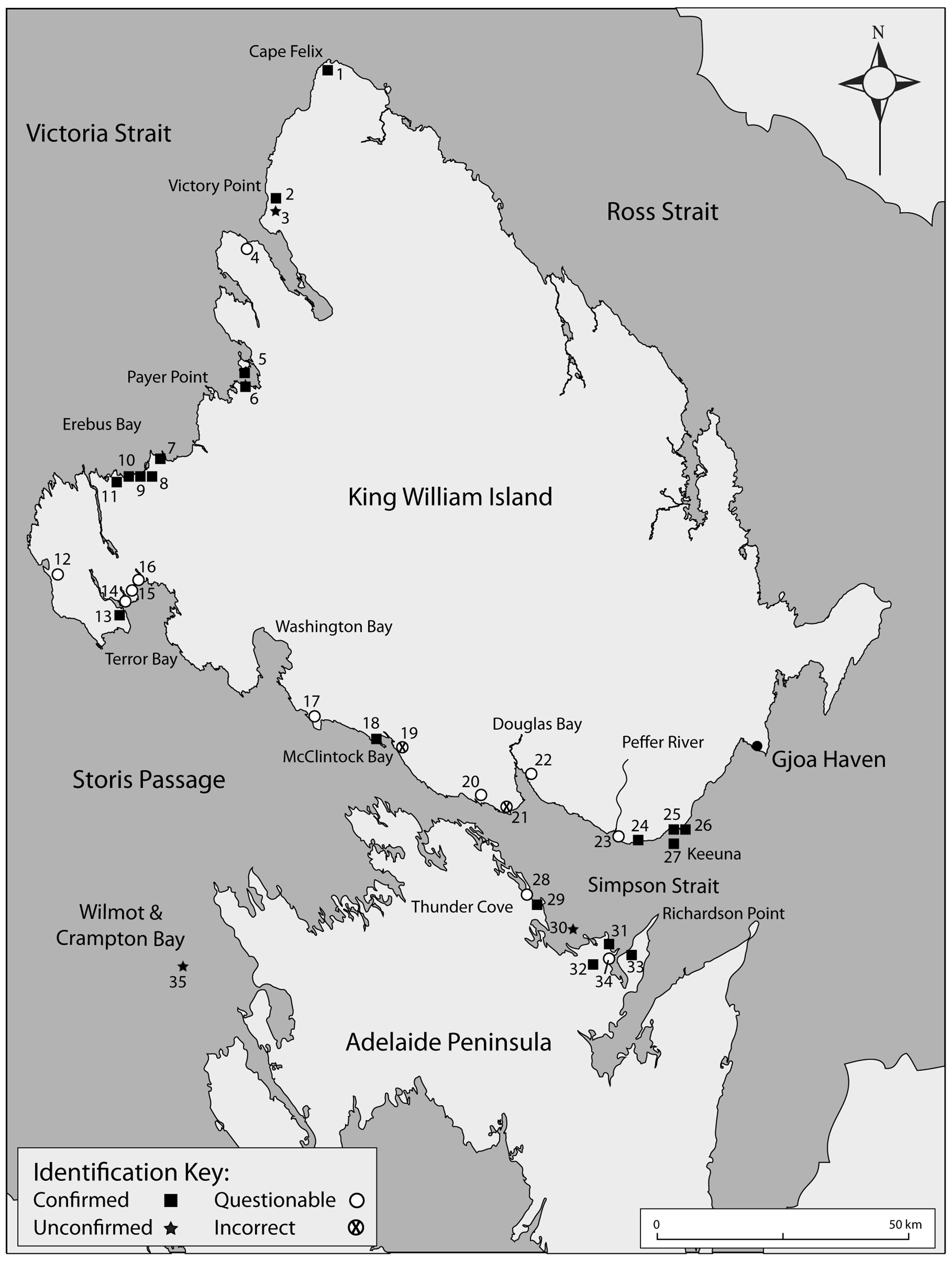
Fig. 1. Locations on King William Island and Adelaide Peninsula where human remains attributed to the Franklin expedition have been reported or found.
For discussion purposes, identifications based on these discoveries are grouped into four reliability categories: Confirmed, Unconfirmed, Questionable, and Incorrect (Table 1). Nineteen identifications are classified as Confirmed using one or both of the following criteria: osteological analyses verifying the ancestry of the skeletal remains as Caucasian, and the presence of diagnostic British naval or other artefacts of the period. One site in Terror Bay is assigned to this category based on details contained in Inuit oral testimony recorded in the 19th century. Three identifications classified as Unconfirmed are those for which information needed to verify their attribution to the Franklin expedition is not currently available. Eleven identifications are classified as Questionable; these have been widely accepted to be members of the expedition, but the criteria on which the identifications are based are open to question. Two identifications are classified as Incorrect; one established through analysis of the skeletal remains conducted in 1981, and a second suggested to be incorrect based on evidence discussed in the present study.
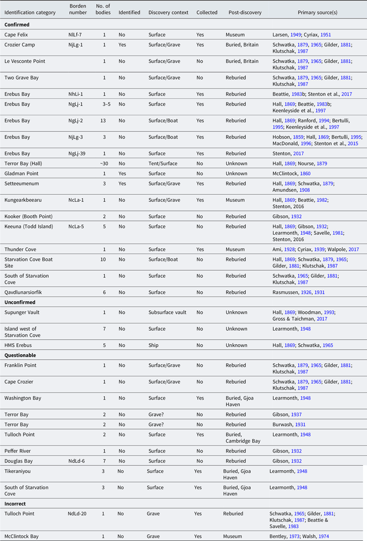
Table 1. Discovery locations of human remains found on King William Island and Adelaide Peninsula attributed to the 1845 Franklin northwest passage expedition
Confirmed identifications
Cape Felix (NlLf-7) (Fig. 1, site no. 1)
In May 1859, a Franklin expedition tent camp was discovered at Cape Felix by the McClintock search expedition, and was revisited 20 years later in July 1879 by the Schwatka expedition (Hobson, Reference Hobson1859; Schwatka, Reference Schwatka and Stackpole1965; Stenton, Reference Stenton2014). Substantial quantities of naval artefacts were found by both search parties, but no graves or human remains were found. In August 1949, RCMP Inspector Henry Larsen found eight pieces of a human skull and the midshaft portion of a long bone on a beach ridge approximately 60 m above sea level and half a mile inland from Cape Felix (Cyriax, Reference Cyriax1951; Larsen, Reference Larsen1949, p. 6). The bones were discovered a short distance from a disturbed stone cache in which Larsen found four Inuit artefacts (two harpoon heads, bone knife handle, bone hook). Anthropologist Douglas Leechman examined the skeletal remains and identified them as a young, Caucasian male, possibly 25 years of age, and “somewhat light and delicate, almost effeminate in build” (Leechman, Reference Leechman1949). In addition to the human bones, Leechman identified a partial molar tooth from a polar bear in the Cape Felix bone assemblage. Based on Leechman’s conclusions, the skeletal remains found by Larsen near Cape Felix have been accepted as being a member of the Franklin expedition. A human skull was discovered near NlLf-7 in 2009 (A. Stirling, personal communication, 1 January 2018) but attempts to relocate it in 2016 were unsuccessful. NlLf-7 has been examined multiple times over the past 35 years (e.g. Bertulli, Reference Bertulli1995a; Gross, Reference Gross2003; Stenton, Reference Stenton2017; Trafton, Reference Trafton1991), but no other human remains are known to have been found at or near the site.
Crozier Camp (NjLg-1) (Fig. 1, site no. 2)
The temporary camp used in April 1848 by the 105 survivors prior to their departure for the Back River was found by the McClintock search expedition in May 1859 (Hobson, Reference Hobson1859). Large quantities of equipment and supplies were discovered at the site, but no human remains. In June 1879, the Schwatka search expedition examined the site and found a disturbed surface grave on the crest of a ridge approximately 25 m above the high-water mark. A human skull was found just outside the grave; the larger bones were scattered over a wide (but undefined) area, and the smaller bones were missing (Schwatka, Reference Schwatka1879, p. 138). Artefacts found in the grave were consistent with the burial of a naval officer (e.g. gilt buttons, glass from a marine telescope), who was identified as Lieutenant John Irving based on the discovery in the grave of a mathematics medal awarded to him in 1830 (Schwatka, Reference Schwatka1879, pp. 137–138, Reference Schwatka and Stackpole1965, p. 80). On 13 July, on the southwards return trip from Cape Felix, a monument was erected over the Irving grave and a stone marked to identify it as such (Gilder, Reference Gilder1881, p. 151). NjLg-1 has been the subject of multiple archaeological investigations over the past 35 years, but no other human remains have been found at the site (Beattie, Reference Beattie1982; Gross, Reference Gross2003; Kowal, Reference Kowal1996; Stenton, Reference Stenton2017).
Le Vesconte Point (Fig. 1, site no. 5)
Le Vesconte Point is located at the northeastern terminus of Erebus Bay, and forms the southern boundary of the entrance to Grover Bay. On 17 July 1879, Schwatka found a disturbed grave near that location and recorded the discovery as follows (Schwatka, Reference Schwatka1879):
On the 17th when on a small cape in Erebus Bay, about Pt. Le Vesconte as near as could be determined we suddenly came upon a human femur and a little farther on a portion of a pelvis. A diligent search soon revealed the grave and a number of the other bones including the skull upon a low sandy point over a hundred yards from where the first bones had been discovered. The grave was a very shallow one dug in the sand and walled in with stones. It contained quite an amount of fine quality navy blue cloth and gilt buttons from which circumstances I inferred that the person here buried had been an officer. The incomplete skeleton was carefully gathered reburied in its old grave and a stone monument built to mark the spot. (p. 141)
Klutschak’s expedition route map (on which Le Vesconte Point is mislabelled) places this grave approximately 5 km south of Le Vesconte Point, on a sandy point of land that forms the north side of the entrance to Two Grave Bay (Fig. 2). Assuming that all of the bones found, some more than 90 m away, originated from the grave, the artefacts found within it support the interpretation that an officer from the Franklin expedition had been buried there. That the grave had been dug into the sand and walled with stones was highlighted by Klutschak (Reference Klutschak and Barr1987), who suggested that the manner in which the grave had been constructed reflected the failing strength of the members of the burial party, and their inability to build an above-ground crypt using large rocks (Klutschak, Reference Klutschak and Barr1987, p. 93). Klutschak made a similar observation about a grave found several months later at Tulloch Point (Gilder, Reference Gilder1881, p. 286; Schwatka, Reference Schwatka1879, p. 154); however, the grave at Le Vesconte Point is a relatively short distance (45 km) from the retreating group’s point of departure south of Victory Point, and the decision to dig a shallow grave may have been influenced by other factors, including the deceased’s rank, the availability of large rocks, and the relative ease of digging a grave in the sand versus constructing one from large boulders.

Fig. 2. Locations of two graves found by the Schwatka expedition at Two Grave Bay in July 1879. Number ‘6’ is Le Vesconte Point. (Library and Archives Canada, Acc. No. 1993-447-19:f.)
Two Grave Bay (Fig. 1, site no. 6)
Two Grave Bay lies immediately south of Grover Bay and is separated from it by a narrow peninsula that widens to form the base of Le Vesconte Point. Its name derives from the discovery on 17 July 1879 of a second grave south of the one near Le Vesconte Point. Schwatka’s journal entry for the second grave follows that for the Le Vesconte Point find (Schwatka, Reference Schwatka1879):
Going into camp about four miles farther on Toolooah, who had arrived ahead of us, showed us a despoiled grave containing a large sailor’s belt buckle and some musket caps. A large skull of a white man was found about a quarter of a mile distant, but so effectively had the mutilated sepulchre been rifled that nothing else could be found, and had it not been for Toolooah’s sharp eyes I doubt not but that we would have passed it without notice. (p. 141)
The location of the second grave is unclear. In his journal, Schwatka described the two graves as being about four miles apart, an estimate that would be correct if the first grave had actually been found at Le Vesconte Point. Confusingly, Schwatka elsewhere stated that the second grave was found on Payer Point (Schwatka, Reference Schwatka1881, p. 254). The relative positions of the burial monuments shown on Klutschak’s expedition map, when projected onto contemporary maps, suggest the two sites were about 2 km apart, and approximately 7 km (4.5 miles) east of Payer Point, where Schwatka camped on 17 July (Fig. 2). Assuming the skull found more than 400 m from the grave originated from it, the two artefacts found within the grave support the conclusion that a member of the Franklin expedition had been buried there. A monument was erected at the grave on 18 July. Surveys conducted in 1982 (Beattie, Reference Beattie1983a) and in 1996 (MacDonald, Reference MacDonald1998) included the Grover Bay and Two Grave Bay area, but neither of the graves described by the Schwatka expedition were identified.
Erebus Bay (Fig. 1, sites no. 7–11)
Erebus Bay is one of the most intensively studied locations where members of the Franklin expedition perished. In 1859, the skeletons of two individuals were found in a boat near the southern boundary of Erebus Bay (Hobson, Reference Hobson1859; McClintock, Reference McClintock1860; Stenton, Reference Stenton2014, p. 518). Published accounts of the McClintock expedition contain no information about how the human remains were treated post discovery, but they were not buried. In what is generally accepted to be 1861, a group of Inuit visited the same site and reported seeing the remains of as many as five individuals (Hall, Reference Hall1869; Nourse, Reference Nourse1879, p. 403). That same group also found a second boat nearby, in and near which they observed a large quantity of human skeletal remains, including seven skulls (Hall, Reference Hall1869; Stenton & Park, Reference Stenton and Park2017). Inuit dismantled the boats found at both sites and the human remains were left on the ground. In 1879, Schwatka relocated the boat site found in 1859 by McClintock and collected and buried 76 human bones he found scattered on the ground, which he believed were from four individuals (Schwatka, Reference Schwatka and Stackpole1965, p. 88; Stenton et al., Reference Stenton, Keenleyside and Park2015, p. 40).
Archaeological investigations conducted at Erebus Bay between 1982 and 2016 have identified five sites (NhLi-1, NgLj-1, NgLj-2, NgLj-3, NgLj-39) collectively containing more than 500 human bones representing a minimum of 21 members of the Franklin expedition (Beattie, Reference Beattie1982, Reference Beattie1983b; Bertulli, Reference Bertulli1995a; Keenleyside et al., Reference Keenleyside, Bertulli and Fricke1997; Mays & Beattie, Reference Mays and Beattie2016; Ranford, Reference Ranford1994; Stenton & Park, Reference Stenton and Park2017; Stenton et al., Reference Stenton2015, Reference Stenton2017).
Terror Bay (Fig. 1, site no. 13)
A Franklin tent camp at Terror Bay, containing the corpses of a large number of Franklin’s men, was discovered by Inuit in the spring of what is thought to be 1849 (Hall, Reference Hall1869, Diary 24). A group of Inuit who visited it in 1861 placed the site at or near the head of the bay, although Hall described it as being just north of Fitzjames Island and about half a mile from shore (Hall, Reference Hall1869, Diary 24). The site was described as consisting of two large, rectangular tents, one of canvas and collapsed, and the second identified by a rectangular outline of rocks, and three graves nearby. Hall was not able to visit the site, but he was told that anyone who visited in the summer months would see all the skeletons and various artefacts, such as lead balls (i.e. lead shot or musket balls). However, four years later, most or all of the site had evidently disappeared. Schwatka and Gilder spent the month of August 1879 searching for it, but Inuit later informed Schwatka that the last vestiges of the site had been washed away by the sea six years earlier (Schwatka, Reference Schwatka and Stackpole1965, p. 94). Recent efforts to identify the location of this important archaeological site have not been successful (Stenton, Reference Stenton2015, Reference Stenton2017).
Gladman Point (Fig. 1, site no. 18)
On 24 May 1859, McClintock discovered the partial skeletal remains of a single individual, clothing fragments, and personal items at Gladman Point (McClintock, Reference McClintock1860, pp. 248–249). The location of the discovery is commonly reported as being at or very near Cape Herschel (Cyriax, Reference Cyriax1939, p. 170; Potter, Reference Potter2016, p. 41); however, McClintock clearly stated that the skeleton was found “9 miles east of Cape Herschel”, placing it correctly at Gladman Point (McClintock, Reference McClintock1860, p. 339). Among papers found in a pocket-book discovered with the remains was a seaman’s certificate bearing the name of Petty Officer Harry Peglar of HMS Terror; however, a detailed analysis of the contents of several handwritten papers also found in the pocket-book suggested the possibility that the remains were those of Peglar’s friend, Thomas Armitage, Gunroom Steward on HMS Terror (Cyriax & Jones, Reference Cyriax and Jones1954). As at Erebus Bay, the bones found at Gladman Point by McClintock were not collected, and the reports provide no details concerning their treatment post discovery.
Setteeumenun (Fig. 1, site no. 24)
In May 1869, Hall searched for the graves of two white men discovered by Inuit at a place known as Set-tee-u-me-nun, on the south shore of King William Island between Booth Point and the Peffer River. Hall initially placed the site at the “mouth of Peffer River” and on “the east side of the mouth of Peffer River” (Hall, Reference Hall1869, Book 31, p. 10), but he clarified the location as being between 3 and 4 km east of the mouth of the Peffer River: “2 to 2 1/2 m. from ridge by monument to Peffer River” (Hall, Reference Hall1869, Book 32, p. 5; Nourse, Reference Nourse1879, p. 467). This would place the site near James Ross Point.
Inuit provided Hall with a detailed description of the site, which included at least one tent ring, and the details of their investigation of it (Hall, Reference Hall1869, Book 31):
The bodies were buried by placing stones around & over them - the remains facing upward & the hands had been folded in a very precise manner across the breasts of both - clothes all on and flesh all on the bones. On the back of each a suspended knife found. The bodies perfect when found but the Innuits having left the remains unburied after unearthing them the foxes have eaten meat & sinews off all the bones. A tenting place by the whites close by where these 2 men were buried. Many needles & one nail found by the Innuits at this tenting place. (Book 31, pp. 7–8)
The site was snow-covered at the time of Hall’s visit, but one grave was located and the skeleton was removed. A cairn was erected over the grave into which Hall incorporated a stone inscribed: “Hall, May XII 1869, Eternal Honor to the Discoverers of the North-West Passage” (Hall, Reference Hall1869, Book 32, p. 5). The skeleton was returned to England in 1872 and tentatively identified as Lt. Henry T. D. Le Vesconte, HMS Erebus. Re-analysis of the remains, including isotopic data and forensic facial reconstruction, suggested the individual might instead have been Harry D. S. Goodsir, Assistant Surgeon, HMS Erebus (Mays et al., Reference Mays, Ogden, Montgomery, Vincent, Battersby and Taylor2011).
In June 1879, Schwatka visited the site and reported finding a third grave, but due to snow cover nothing else was seen (Schwatka, Reference Schwatka1879, p. 132, Reference Schwatka and Stackpole1965, p. 73). In August 1904, Setteeumenun was visited by Godfred Hansen, second-in-command of the Amundsen Northwest Passage expedition (Amundsen, Reference Amundsen1908). Hansen referred to the location as ‘Point C. F. Hall’ and he was unmistakably at the same location from which Hall had removed a skeleton (Hansen, Reference Hansen and Amundsen1908, Suppl.):
On the way we found some skulls and bones of two white men. They were lying scattered over the low foreshore at Point C. F. Hall and had been placed by this Arctic explorer under a stone cairn. Close by we found the stone on which he had cut the words “Eternal Honor to the Discoverers of the North-West Passage.” We collected the bones together again and covered them over with stones, on top of which we placed Hall’s stone. (p. 297)
Hansen’s reference to the discovery of skulls and bones of two white men would appear to corroborate Schwatka’s report of the existence of a third grave at the site. No sites matching the description of Setteeumenun were reported from surveys conducted in the area in 1973 and in 1981 (Bentley, Reference Bentley1973; Savelle, Reference Savelle1981).
Kungearkbeearu (NcLa-1) (Fig. 1, site no. 25)
Kungearkbeearu is a flat, sandy spit of land located 2 km west of Booth Point, on the south coast of King William Island. Inuit reported finding a grave of a white man at Kungearkbeearu, and Hall searched the location in May 1869 (Hall, Reference Hall1869). Due to snow cover, no remains were found, and Nourse (Reference Nourse1879) summarised Hall’s visit as follows:
After traveling about a half hour, the party halted on a long, low spit, called by the natives Kung-e-ark-bee-ar-u, on which the men last named “knew that a white man had been buried.” This, however, was chiefly from the accounts they had had from their people; only one of these had ever seen the grave. The spot was pointed out, but the snow covered all from view. A monument was erected, and its bearings from Kee-u-na carefully noted. (pp. 401–402)
Nourse’s abridged version of Hall’s journal entry about this site omitted important details. The original reads as follows (Hall, Reference Hall1869, Diary 31):
Name of the place where the one white man is buried: Kung-e-ark-bee-ar-u. Either Tet-kee-ta or his father 1st found this grave. The grave & remains same perfect methodical state when found as the 2 at mouth of Peffer River. This grave on KWL about due N of Kee-u-na. The body dug up and left unburied by the Innuits. This white man very large & tall & by the state of gums of lower teeth in terrible sick (bad) state as In-nook-poo-zhe-jook described. He said that one man, a large tall man, was seen by Ow-wer & other Innuits when they met Ag-loo-ka and this man presented a terrible site about his lower gums & from the observation made at grave of the one white man, the Innuits concluded he must be the same man. (pp. 10–11)
In 1981, 31 human bone fragments were found at NcLa-1, scattered around a feature described as an atypical tent ring or similar structure (Beattie, Reference Beattie1983b, p. 70; Beattie & Savelle, Reference Beattie and Savelle1983, pp. 101–102). Two artefacts consistent with a mid-19th century date were also found, but no evidence for a grave and, citing Nourse, it was speculated that Hall’s account of a grave might have been the result of an error in translation (Beattie & Savelle, Reference Beattie and Savelle1983, p. 100).
Morphological analysis of the bones indicated the individual was an adult, Caucasian male, estimated to be 20–25 years old (Beattie & Savelle, Reference Beattie and Savelle1983, p. 102; Beattie, Reference Beattie and Sutherland1985, p. 144). Three cut marks found on a right femur were consistent with anthropogenic modification related to cannibalism, the first physical evidence of it to have been identified (Beattie & Savelle, Reference Beattie and Savelle1983, pp. 102–103; Mays & Beattie, Reference Mays and Beattie2016). New investigations were conducted at NcLa-1 in 2016 (Stenton, Reference Stenton2017). The feature reported in 1981 and the surrounding area were mapped in detail, and surface collections and test excavations were conducted. More than 100 artefacts, several bearing the Royal Navy broad arrow, were found, and a human tooth and a femur were recovered through excavation. DNA analysis performed on two of the bones recovered from the site in 1981 and on the bone and tooth recovered in 2016 indicated that they were from a single individual of European ancestry (Stenton et al., Reference Stenton, Keenleyside, Fratpietro and Park2017).
Kooker (Fig. 1, site no. 26)
In his journal entry for 11 May 1869, Hall recorded a landmark near Todd Island known as Koo-ker, where Inuit reported finding a grave of one of Franklin’s men (Hall, Reference Hall1869, Diary 30): “We are now passing what In-nook-poo-zhe-jook says is Koo-ker on KW & an islet near it called Now-yarn. At Koo-ker is the grave of one of Franklin’s men & of course we shall by & by D.V. visit it” (p. 14).
Hall did not visit the site, but in 1931 the easternmost of the two large islands of the Todd Island group, situated adjacent to the coast of King William Island was searched (Gibson, Reference Gibson1932, p. 404). From the description, the island searched was Kooker, which is the headland of Booth Point connected to King William Island by a narrow sand isthmus. Two skulls were found embedded in the sand and post-cranial remains were exposed through excavation of the surrounding area (Gibson, Reference Gibson1932, p. 404). Disintegrated fragments of textile thought to be clothing remnants were also found, but no evidence of a pre-existing grave or cairn was seen. The bones were buried on site beneath a cairn.
Keeuna (Fig. 1, site no. 27)
In May 1869, Hall visited an island called Keeuna (Todd Island), located approximately 3 km south of Kungearkbeearu, where Inuit had reported finding the unburied bodies of five of Franklin’s men. Hall found a portion of a human femur, which had been gnawed by foxes (Hall, Reference Hall1869, Diary 30, p. 22), and he was shown the place where the five bodies had been seen, at the southeastern end of the island, within approximately 20 fathoms (36 m) of the shore (Hall, Reference Hall1869, Diary 34, p. 7). When first seen by Inuit, all of the bodies were intact, clothed and lying on the surface of the ground, but the corpses were subsequently mutilated by their dog teams. Among the items found with the bodies was a can of unopened meat, which was opened and eaten by the Inuit. Hall erected a commemorative cairn on Keeuna but did not find any additional human remains. In 1931, a skull was found embedded in the sand of a “low spit which ran out from the island to the westward” (Gibson, Reference Gibson1932, p. 404). Clearing of the sand revealed an almost complete skeleton, extended and in natural position. The good condition of the teeth suggested the individual was a young man. One femur and several ribs and vertebrae were found nearby, which were considered to be part of a second skeleton. Naval cloth fragments, some well-preserved, were also found. The remains were buried nearby beneath a small cairn (Gibson, Reference Gibson1932, p. 405).
The bones of four of Franklin’s men were reported as having been removed from the Todd Islands in 1942 by Learmonth and taken to Gjoa Haven, where they were buried under a cairn (Learmonth, Reference Learmonth1948a, p. 122). The specific recovery locations and contexts were not described, but they were reported as having been removed from the ‘islands’ (plural) and, if correct, and because both locations had been marked with cairns, it is possible that these were the remains of the two individuals found at Kooker, and the two found on the west side of Keeuna in 1931 (Gibson, Reference Gibson1932). Learmonth’s original correspondence, however, on which the 1948 article was based, contains no mention of his ever having visited the Todd Islands or removed skeletal remains from them (Learmonth, Reference Learmonth1948b). In 1982, human skeletal remains thought to be two members of the Franklin expedition were found near a disturbed stone cairn located on the east end of a spit that forms the southwest part of Todd Island (Savelle, Reference Savelle and Sutherland1985). The location appears to match Gibson’s description of where he had buried the remains of two individuals in 1931. A second scatter of human bones was found 100 m east of the cairn, near two tent rings, which were thought to be of recent age (Savelle, Reference Savelle and Sutherland1985, p. 200). Between 2000 and 2014, human skeletal remains were seen on Keeuna in the same general locations where they had been reported by previous searchers (Canadian Broadcasting Corporation, 2000; Gross, Reference Gross2006, personal communication, 4 December 2017; Solomon, Reference Solomon2014). Todd Island was visited briefly in 2008 and again in 2016, when a surface bone assemblage on the southwest side of the island was collected for analysis. It consisted of a mixed assemblage of eight caribou bones, eight human bones and one human tooth (Stenton, Reference Stenton2009, Reference Stenton2017). The results of DNA analysis of samples taken from the tooth and from one bone were not consistent with Inuit ancestry (Stenton et al., Reference Stenton, Keenleyside, Fratpietro and Park2017).
Thunder Cove (Fig. 1, site no. 29)
In 1926, a human skull, and pieces of navy cloth, shoe leather and oak were found by trader Peter Norberg at Thunder Cove, a small cove on the north shore of Adelaide Peninsula, approximately 3 km south of Reid Island (Cyriax, Reference Cyriax1939, p. 174; Walpole, Reference Walpole and Potter2017, p. 122). The skull was examined by anthropologists Diamond Jenness and Douglas Leechman at the Victoria Memorial Museum (Canadian Museum of Nature), who identified it as European, and by geologist and palaeontologist Henry Ami at the Geological Survey of Canada (Ami, Reference Ami1928). Ami concurred that the skull was that of a young, male European and, presumably, an Englishman (Ami, Reference Ami1928, p. 322). No sites associated with the Franklin expedition were identified through aerial and foot surveys conducted near Thunder Cove in 2016.
Starvation Cove Boat Site (Fig. 1, site no. 31)
Starvation Cove (Schwatka, Reference Schwatka and Stackpole1965, p. 74) and the surrounding area is the furthest point on the south shore of Simpson Strait where remains of members of the expedition have been found. In the summer of 1879, Schwatka’s interpreter, Ebierbing, searched the site and found one skull, an unspecified number of other human bones, pieces of blue navy cloth, footwear, and other items (Cyriax, Reference Cyriax1939, p. 174; Schwatka, Reference Schwatka1879, p. 153, Reference Schwatka and Stackpole1965, p. 96). In November 1879, Klutschak returned to the site, gathered the bones and the relics that had been left there, and buried them. A monument in the shape of a cross was erected over the spot (Klutschak, Reference Klutschak and Barr1987, p. 133). In 1949, Larsen searched the Starvation Cove area but found no human remains, and none were found during a brief survey conducted in 2015 (Larsen, Reference Larsen1949; Stenton, Reference Stenton2015).
Hill South of Starvation Cove (Fig. 1, site no. 32)
In November 1879, the Schwatka expedition also interred the skeleton of another expedition member, found on a hill approximately four to five miles south and slightly east of Starvation Cove (Klutschak, Reference Klutschak and Barr1987, p. 134; Schwatka, Reference Schwatka1881, p. 255). Klutschak was guided to the site by a boy who showed him the remains of clothing, and although Klutschak did not specifically mention finding any skeletal remains (Klutschak, Reference Klutschak and Barr1987, p. 134), both Gilder (Reference Gilder1881, p. 210) and Schwatka (Reference Schwatka1881, p. 255) stated that the skeleton of a white man was found at the site, together with pieces of clothing indicating that he was not an officer. The bones were buried and the spot was marked by a stone cairn.
Qavdlunarsiorfik (Fig. 1, site no. 33)
In 1923, Knud Rasmussen was told of the discovery by three hunters of the bodies of six white men in a boat on Adelaide Peninsula at a place called Qavdlunarsiorfik. The location was described as “almost opposite the place where Amundsen wintered” (i.e. Gjoa Haven) (Rasmussen, Reference Rasmussen1931, p. 131), known as Nuvuteroq, which is Richardson Point (Rasmussen, Reference Rasmussen1931, p. 101). Rasmussen visited Qavdlunarsiorfik and found an unspecified number and type of human bones, as well as pieces of cloth and leather footwear indicating the deceased were white men. The bones were collected and buried at the site beneath a cairn. The caption of a photograph of the cairn describes the site as near, rather than at, Starvation Cove (Rasmussen, Reference Rasmussen1931, p. 440; Woodman, Reference Woodman1991, p. 149).
Unconfirmed identifications
Supunger Vault (Fig. 1, site no. 3)
In 1866, Hall recorded the testimony of an Inuk named Supunger concerning the discovery of a stone crypt or vault containing the partial remains of a member of the Franklin expedition (Gross & Taichman, Reference Gross and Taichman2017; Hall, Reference Hall1869; Nourse, Reference Nourse1879; Woodman, Reference Woodman1993). Similar information about the existence of a burial vault, purportedly John Franklin’s grave, was also obtained from Pelly Bay Inuit by Peter Bayne, a whaler temporarily employed by Hall on his second expedition (Gross & Taichman, Reference Gross and Taichman2017, p. 2). The location of the vault feature described by Supunger is unknown, but based on details contained in the recorded accounts it is generally thought to be on the northwest coast of King William Island, in the vicinity of the Crozier camp near Victory Point (NjLg-1) (Woodman, Reference Woodman1993). Since 1930, multiple searches for the vault have been conducted at NgLj-1 and in the surrounding area between Wall Bay to the north and Cape Jane Franklin to the south but no evidence for it has been found, nor have any Caucasian skeletal remains been found (Bertulli, Reference Bertulli1995b; Kowal, Reference Kowal1996; Woodman, Reference Woodman1993, Reference Woodman1995).
Islands west of Starvation Cove (Fig. 1, site no. 30)
In 1942, a search was conducted for human skeletal remains on several of a group of small islands situated approximately 10 km west of Starvation Cove (Learmonth, Reference Learmonth1948a). The search was initiated based on Inuit testimony about the discovery in the 1870s of seven skeletons of white men, still partly clothed, on a small island in that area. The number and specific locations of the islands searched is unknown, but no human remains were found (Learmonth, Reference Learmonth1948a, p. 123).
HMS Erebus (Fig. 1, site no. 35)
Inuit accounts of their discovery of a shipwreck at Ook-joo-lik (Wilmot and Crampton Bay) include descriptions of a body of a man found on board (Hall, Reference Hall1869; Schwatka, Reference Schwatka1879). The man was described as being very large and of great stature, requiring (perhaps figuratively) five Inuit to lift him, and having teeth as long as Inuit fingers (Hall, Reference Hall1869, Book 22, p. 4). A similar account reported the discovery by Inuit of a body in a bunk in the back part of the ship (Schwatka, Reference Schwatka1879, p. 126). The ship described by Inuit as containing the body was confirmed in 2014 as the wreck of HMS Erebus, but to date no human remains have been identified at the site.
Questionable identifications
Franklin Point (Fig. 1, site no. 4)
On 24 June 1879, while searching the northwest coast of King William Island, Schwatka’s party found a human skull near Franklin Point (Schwatka, Reference Schwatka1879):
About halfway between Franklin Pt. and Cape Jane Franklin - which points by the way are about half as far apart as charted on the Admiralty map - Frank found a skull near an old dilapidated looking grave built on the surface of the ground of the loose stones lying about. Toolooah pronounced it unhesitatingly that of a white man, and it certainly was too high and noble looking in the coronal region to believe that it belonged to the stolid natives of this locality. There was, however, no other confirmatory proof of a white man’s grave, but believing it so very possible that it might be one of the lost Franklin crew I reconsigned it to its rough sepulchre and built a slight monument of the loose stones over the few bones found. (p. 137)
Klutschak’s account of the discovery differs slightly from that of Schwatka, to whom Klutschak attributed the identification of the skull as Caucasian (Klutschak, Reference Klutschak and Barr1987):
In a cairn on Franklin Point which had the appearance of a grave built above ground, we found a skull which Lieutenant Schwatka immediately identified as that of a white man. After a thorough search of the grave the skull was buried and the spot marked by a small monument. (pp. 81–82)
The description of the grave places it along the coast southeast of Franklin Point, midway between it and the spot from which they crossed the ice of Collinson Inlet to Cape Jane Franklin. The cairn marking the burial at Franklin Point was erected three weeks after its discovery, on July 13, during the return trip from Cape Felix (Gilder, Reference Gilder1881, p. 151).
Cape Crozier (Fig. 1, site no. 12)
In August 1879, Schwatka found human skeletal remains and a disturbed grave on the central west coast of Graham Gore Peninsula (Schwatka, Reference Schwatka1879, p. 146):
On the 15th I discovered an incomplete skeleton near Cape Crozier the skull of which showed the unmistakable high Caucasian contour, a dilapidated grave near by having probably been its receptacle before its desecration at the hands of the wandering seal hunters of the Esquimaux. The bones were re-entombed in their former resting place and the usual monument erected to mark the sad spot. (p.146)
The Schwatka expedition map places the grave approximately 8 km south–southeast of Cape Crozier, just south of a cove on the central coastline of Graham Gore Peninsula. In 1997, 30 sites were recorded through archaeological surveys conducted along the west coast of Graham Gore Peninsula (MacDonald, Reference MacDonald1998), including the general area where Schwatka found the skeletal remains, but no feature matching its description was identified.
Terror Bay (Fig. 1, sites no. 14–16)
In 1930, a disturbed grave, possibly containing two or more individuals, was found at an unspecified location at Terror Bay (Burwash, Reference Burwash1931). The bones were not described, no artefacts were found with the remains, and the reason for thinking that it contained more than one individual was not stated (Burwash, Reference Burwash1931, p. 94). In 1937, two photographs of cairns at Terror Bay were published and captioned as containing the remains of members of the Franklin expedition (Gibson, Reference Gibson1937, p. 68). The locations of the cairns were not given, and the basis for attributing them to the Franklin expedition was not stated.
Washington Bay (Fig. 1, site no. 17)
In June 1942, a skull and other human bones were found on the east side of the entrance to Washington Bay, a short distance north of Cape John Herschel (Learmonth, Reference Learmonth1948a, p. 122). The type, condition and recovery context of the bones (e.g. scattered on the ground surface, found in or near a grave or other feature types) were not reported. The bones were removed from the site, taken to Gjoa Haven and buried.
Tulloch Point (Fig. 1, site no. 20)
In June 1942, two human skulls were found on the beach several kilometres west of Tulloch Point (Learmonth, Reference Learmonth1948a, p. 122). Few details about the discovery are known, but Learmonth considered the remains to be those of members of the Franklin expedition. Both skulls were removed and turned over to the Royal Canadian Mounted Police at Cambridge Bay, who buried them near the grave of trader Patsy Klengenberg (Learmonth, Reference Learmonth1948a). In 1973, personnel involved in Exercise Northern Quest found a human skull at Tulloch Point, but it does not appear to have been explicitly attributed to the Franklin expedition (Bentley, Reference Bentley1973).
Douglas Bay (Fig. 1, site no. 22)
In 1931, human skeletal remains representing a minimum of seven individuals were found on a small island located approximately 500 m off the east-central shore of Douglas Bay (Gibson, Reference Gibson1932, Reference Gibson1937). Also found were several small pieces of wood, one with nail holes, and wood shavings, identified as oak and possibly Norwegian pine. Two tent rings were observed, which were thought to be Inuit constructions. The bones were gathered up and buried in a cairn on a rocky knoll forming the highest point of the island. The site was revisited by archaeologists in 1981, by which time the cairn had been dismantled and the skeletal remains removed (Beattie & Savelle, Reference Beattie and Savelle1983, p. 104). The site was visited briefly in 1995 (Ranford, Reference Ranford1995, p. 3), and in 2014, when eight features and two human bones were recorded (Stenton, Reference Stenton2015). The eastern shoreline of Douglas Bay was searched in 1973 by Exercise Northern Quest (Bentley, Reference Bentley1973) and in 1981 by Savelle (Reference Savelle1981) but no human remains were found.
Peffer River (Fig. 1, site no. 23)
In the spring of 1931, a human femur, described as being of unusual length, and several human vertebrae were found near the edge of the sea-ice on the south shore of King William Island at the mouth of the Peffer River (Gibson, Reference Gibson1932, p. 405, Reference Gibson1937, p. 67). It was speculated that other bones that might once have been present had been washed away by high tides. The bones were buried and a small cairn was erected over the spot (Gibson, Reference Gibson1932, p. 405). No human remains were found by shoreline surveys near the mouth of the Peffer River in 1973 or in 1981 (Bentley, Reference Bentley1973; Savelle, Reference Savelle1981).
Tikeraniyou (Fig. 1, site no. 28)
In 1936, Learmonth found the skeletal remains of three men, a large ivory button, and a George IV Half Crown at a place known as Tikeraniyou (Learmonth, Reference Learmonth1948a, p. 122). The location was described as a point of land shaped like a crooked finger located 12–15 miles west of Starvation Cove. The skeletal remains and artefacts were found where the land bent to the southwest. The exact location of Tikeraniyou is uncertain. Learmonth’s distance approximation places the site on the north coast of Adelaide Peninsula somewhere between Thunder Cove and a spot in the vicinity of Reid Island to the northwest. The coastline between these two locations doesn’t appear to bear any obvious similarity to a bent or a crooked finger, but the shape of a long, narrow island 1 km north of Reid Island does bear a likeness to a bent finger, and its western end bends to the southwest. Several named islands situated along this same section of the north coast of Adelaide Peninsula were recorded by Rasmussen, including ‘tikeranajuk’, meaning ‘the little forefinger-like’ (Rasmussen, Reference Rasmussen1931, p. 102). The 1936 discovery was made in August, however, and had it been made on an island rather than the mainland Learmonth would, presumably, have clearly indicated that. No details were provided about the type or quantity of bones found. The remains were taken to Gjoa Haven where they were buried beside the Hudson’s Bay Company Post.
Southeast of Starvation Cove (Fig. 1, site no. 34)
In 1942, one skull, portions of two other skulls, three mandibles, and many large bones were found close to an old Inuit seal cache approximately 2 km southeast of Starvation Cove (Learmonth, Reference Learmonth1948a). Many of the bones were moss-covered, and because the teeth were not worn down, Learmonth considered them to be non-Inuit and those of three Franklin expedition members. No artefacts were reported. The bones were removed from the site and buried at Gjoa Haven, but two small cairns were erected at the site, one where the bones had been found and a second nearby on higher ground (Learmonth, Reference Learmonth1948a, p. 123).
Incorrect identifications
McClintock Bay Area (Fig. 1, site no. 19)
In July 1973, the 1st Battalion, Royal Canadian Regiment, CFB London, conducted Exercise Northern Quest, a training exercise organised around a search for sites and artefacts from the 1845 Franklin expedition (Bentley, Reference Bentley1973; Walsh, Reference Walsh1974). During a search between Gladman Point and Tulloch Point, human skeletal remains, fragments of cloth, and several buttons were removed from a grave situated approximately 1 km southeast of McClintock Bay. The artefact and bone assemblages were sent to the Museum of Man in Ottawa. The remains were reported as having been identified as a European of the period of the Franklin expedition and probably those of a Franklin crewman (Walsh, Reference Walsh1974, p. 24). Information about the artefacts found in the grave is limited (three cloth-covered metal buttons, one pearl button, and unidentified fragments of cloth), but a photograph of the skeletal remains was published and it contains details suggesting that the individual was not a member of the Franklin expedition.
The photograph taken at the site (Fig. 3; Walsh, Reference Walsh1974, p. 24) shows the larger bones arranged in approximate anatomical position on a piece of plywood, with smaller bones grouped on the right side of the skeleton. At the time of discovery, two of the bones were initially mistaken for sticks lying beside a large rock (Walsh, Reference Walsh1974, p. 24); from the photograph, these might have been the left and right femora. Bleaching and weathering of these bones and of several others indicates that they had been exposed for an extended time period. The majority of the bones, however, are dark in colour, indicating they were covered prior to their removal from the grave. The probability that the remains are those of an Inuk is based on the presence of several animal bones in the photograph. The large, dark-coloured bone positioned at the base of the vertebral column and between the pelves is the 1st cervical vertebra (atlas vertebra) from a caribou. To the right of the skeleton, the bone near the edge of the plywood appears to be a caribou metacarpal (possibly the left metacarpal), and on the upper corner of the plywood on the right side of the image is an articulated seal forelimb. Because of the low resolution of the photograph, the possible presence of other animal bones cannot be confirmed. Traditionally, it was not uncommon for Inuit to leave food with the dead, and the presence of seal and caribou bones in the assemblage, combined with a lack of information about the associated artefacts, suggests that the skeletal remains are those of an Inuk rather than a member of the Franklin expedition.

Fig. 3. Mixed assemblage of human, caribou and seal bones found in grave by Exercise Northern Quest in 1973 near McClintock Bay, King William Island. Adapted from Walsh (Reference Walsh1974).
Tulloch Point (Fig. 1, site no. 21)
In September 1879, members of the Schwatka expedition examined a grave at Tulloch Point reported by Inuit to be that of a white man. Nineteen bones were found and, on the strength of Inuit testimony, the grave was considered to be that of a member of the Franklin expedition. In 1931, human skeletal remains found at Tulloch Point were thought to be the same ones reported to the Schwatka expedition (Schwatka, Reference Schwatka1879; Gibson, Reference Gibson1932, Reference Gibson1937). The 1879 Inuit identification of the remains as those of a member of the Franklin expedition was considered to be correct, and the bones were collected and buried in a cairn (Gibson, Reference Gibson1937, p. 69). In 1981, 58 human bones were found at Tulloch Point, in and near the feature described by Gibson in 1931, and from a second feature, a disturbed grave (Beattie & Savelle, Reference Beattie and Savelle1983). These skeletal remains were apparently not seen by Exercise Northern Quest eight years earlier. More than a century after their initial discovery, morphological analysis of the bones revealed them to be Inuit (Beattie & Savelle, Reference Beattie and Savelle1983, p. 104).
Discussion
Fifty-four percent of the locations where human skeletal remains were found on King William Island and Adelaide Peninsula and attributed to the Franklin expedition have either been confirmed through physical analysis (e.g. Ami, Reference Ami1928; Beattie, Reference Beattie1983b; Keenleyside et al., Reference Keenleyside, Bertulli and Fricke1997; Stenton et al., Reference Stenton, Keenleyside, Fratpietro and Park2017) or can reasonably be accepted as confirmed based on supporting archaeological evidence. The mass casualty site reported by Inuit at Terror Bay is an exception; however, based on detailed descriptions of the site obtained in the 19th century, there can be no doubt that the bodies being described were members of the Franklin expedition. The summaries also indicate that 46% of the identifications are unconfirmed, questionable or incorrect. This does not rule out the possibility that some of the skeletal remains falling within the unconfirmed and questionable categories could, in fact, be members of the Franklin expedition; however, the basis on which many were ascribed to the Franklin expedition is either unexplained or ambiguous, and their acceptance as Franklin expedition personnel is open to debate.
The three reports categorised as Unconfirmed lack information needed to support their attribution to the Franklin expedition. Future archaeological investigations on northwest King William Island, at Starvation Cove, and on the wreck of HMS Erebus may ultimately confirm these reports. Surprisingly, nearly one-third of the identifications are categorised as Questionable. Skeletal remains found at Franklin Point, Cape Crozier, Terror Bay and Peffer River have not been relocated, and at Washington Bay and Tulloch Point the bones were removed and reburied elsewhere more than 75 years ago. At Franklin Point and at Cape Crozier, Schwatka’s identifications were based on his appraisal of the shape of the skulls (i.e. “too high and noble looking in the coronal region”; “unmistakable high Caucasian contour”), but he explicitly acknowledged in the case of Franklin Point that there was no evidence to support that conclusion. Nothing found at Cape Crozier would differentiate it from the discovery at Franklin Point, yet Schwatka did not express any reservations about the Franklin expedition identification for the Cape Crozier find. The report of the skeletal remains found at Terror Bay by Burwash contains no information to suggest that the remains were members of the Franklin expedition, and the reasons for the attribution of the two burial cairns shown in the photographs taken at Terror Bay are unknown. Similarly, descriptions of the skeletal remains found by Learmonth at Washington Bay and near Tulloch Point contain no details that would connect them to the Franklin expedition. The bones found at the mouth of the Peffer River were ascribed to the Franklin expedition on the mistaken assumption that it was the same site near Ross Point that was visited by Hall in 1869. In many of these cases, the attribution of the human remains to the Franklin expedition appears to have been strongly influenced by the knowledge that retreating parties had passed through the area, and on the supposition that any remains that were not obviously Inuit, however that might be determined, must have been members of the Franklin expedition.
On Adelaide Peninsula, the recovery of a sailor’s button and the George IV Half Crown at Tikeraniyou is suggestive, but not conclusive, concerning the identification of the bones as members of the Franklin expedition. Inuit encountered by search parties had many items they had collected from Franklin sites (e.g. Rae, Reference Rae1855) and it is conceivable that the two artefacts found at Tikeraniyou were objects in the possession of Inuit. The use of tooth wear as a possible indicator that the remains found south of Starvation Cove were Caucasian was an important observation; however, the processes that produce distinctive patterns of tooth wear associated with gender-specific tasks amongst Inuit populations are complex (Clement & Hillson, Reference Clement and Hillson2012). Thus, while the observed absence of wear on the mandibular teeth could support the interpretation that the deceased were Caucasian, it would not rule out the possibly that they were male Inuit.
One of the most publicised and iconic images of Franklin expedition fatalities is a 1931 photograph of William Gibson standing beside seven human skulls and post-cranial bones gathered from the surface of a small island in Douglas Bay. The site was interpreted to be a camp where at least seven members of the Franklin expedition had died (Gibson, Reference Gibson1932, p. 406) and this assumption appears never to have been questioned. However, in addition to the mysterious disappearance of the bones sometime between 1931 and 1981 (Beattie & Savelle, Reference Beattie and Savelle1983), the site’s location, features, and artefacts raise a number of questions about its possible relationship to the Franklin expedition.
The site’s location in the east-central part of Douglas Bay might, as suggested, have been the result of a group of men encountering conditions of reduced visibility (e.g. drifting snow), travelling far off course, and arriving at the island where they later died (Gibson, Reference Gibson1932, p. 406). It is conceivable that retreating parties became disoriented due to weather conditions or other factors such as deteriorating physical and mental health, and at least one 19th-century British search party had that very experience on King William Island (Stenton, Reference Stenton2014, p. 516). Assuming that travel by sea-ice was still possible at the time, if such an event led a group of men into Douglas Bay, they would have been far off course, heading north–northeast rather than east–southeast towards the Back River.
Information is limited about the two tent rings observed at the site in 1931, which were thought to represent Inuit occupation, but nothing about their size or shape implied that they were European. Inuit reported seeing tents at several Franklin sites, but with the exception of Terror Bay, where the tents were described as large and rectangular (Hall, Reference Hall1869), little is known about tent structures seen by Inuit at other Franklin sites. Two tent rings were observed at NdLd-6 in 1981 (Savelle, Reference Savelle1981), although none were mentioned in the report of a brief 1995 site visit (Ranford, Reference Ranford1995, p. 3). Eight features were identified at the site in 2014, including two tent rings whose locations appear to match the 1931 and 1981 descriptions (Stenton, Reference Stenton2015). If features other than the two tent rings had been observed in 1931 or in 1981, and if any had attributes suggesting they were of non-Inuit origin, that would have been noted by investigators. This suggests the possibility that the six additional features recorded in 2014 post-date 1981, which may accurately reflect the chronology of occupation, although no artefacts to confirm this have been found at the site. In any case, no structural evidence indicative of the site representing a Franklin camp has been found at NdLd-6.
Viewed in the context of its identification as a Franklin expedition site, the nature of the artefact assemblage found at NdLd-6 in 1931 is unusual. Speculation that the assemblage may reflect the dismantling by Inuit of a ship’s boat or possibly a sledge on the island (Gibson, Reference Gibson1932, p. 406) is called into question by comparison of the artefact inventory from NdLd-6 with assemblages from other sites where Franklin expedition boats and sledges are known to have been dismantled by Inuit. At Erebus Bay, sites NgLj-2 and NgLj-3 have collectively yielded nearly 1200 artefacts of copper, iron, lead, canvas, leather, textile, glass, hundreds of nails and hundreds of pieces of discarded wood from boats and sledges (Bertulli, Reference Bertulli1995a; Table 2 in Stenton & Park, Reference Stenton and Park2017). The evidence from the Erebus Bay sites suggests that if a boat or sledge had been dismantled by Inuit at NdLd-6, it would be reasonable to expect a much greater quantity and variety of materials to have been present at the site in 1931 and in subsequent years. If, as the archaeological evidence from NdLd-6 suggests, no expedition boat or sledge was dismantled at the site, it would still be reasonable to expect to find more than a few small pieces of wood at a location where seven members of the expedition had died. At other confirmed Franklin sites where deaths occurred, in many cases in fewer numbers than at NdLd-6, and which have been the subjects of multiple archaeological investigations, items such as buttons, canvas, footwear, clothing, textile fragments and a range of other materials continue to be found.
Table 2. Estimated number of individuals represented by human remains confirmed or attributed to the 1845 Franklin expedition

The disappearance of the skeletal remains found at NdLd-6 in 1931 eliminated the opportunity for osteological analyses that could confirm their ancestry and, thus, their possible affiliation with the Franklin expedition. Two human bones, a partial innominate, and a deeply weathered human mandible were found on the surface of the site in 2014 (Stenton, Reference Stenton2015). It is possible that these bones were present at the site in 1931 and were overlooked, but their origin and ancestry is currently unknown. To summarise, although the identification of the human skeletal remains found in 1931 at NdLd-6 as Franklin expedition personnel has been widely accepted and publicised, it is suggested that the archaeological evidence found at the site does not support that conclusion.
As previously discussed, the only confirmed example of an incorrect attribution of skeletal remains to the Franklin expedition was the misidentification in 1879 of a partial skeleton found by Inuit in a grave at Tulloch Point. This error was the result of uncritical acceptance of Inuit testimony, a disregard for the absence of corroborating evidence, and misinterpretations of the historical record. In 2016, 35 years after they had been removed from the site, the bones were returned and reburied (Stenton, Reference Stenton2017). At McClintock Bay, the proposition that the remains found in 1973 were incorrectly identified as expedition personnel could be further explored through analysis of the artefacts and skeletal remains, but their current location is unknown. The collections were reportedly sent to the Canadian Museum of History, but the museum records list the collections’ location as ‘Unknown’.
Quantification
A basic question arising from the discoveries of the remains of Franklin expedition personnel, and one for which the reliability of identifications is crucially important, is the number of the original 105 men who set out for the Back River that can be accounted for. Knowing where deaths occurred and in what numbers is important to understanding events that transpired during the final stages of the expedition. One method of estimation is to subtract the number of individuals discovered by search expeditions from the 105 who departed for the Back River. This approach is made difficult by the proposition that not all of the identifications are correct, by a lack of information for key locations such as Terror Bay and Starvation Cove, by inconsistencies in the historical records, and the variability of the discovery contexts. Several estimates have, however, been attempted (Cyriax, Reference Cyriax1939; Klutschak, Reference Klutschak and Barr1987; Nourse, Reference Nourse1879; Schwatka, Reference Schwatka and Stackpole1965).
Using information provided by Inuit, who emphasised that it was impossible for them to accurately quantify the number of dead at locations where large numbers of bodies were seen, Hall estimated that 79 men could reasonably be accounted for (Nourse, Reference Nourse1879, p. 403). Hall was attempting to determine the number of men who had died after the meeting between Inuit and the group of white men near Washington Bay, but his calculation includes estimates from the two Erebus Bay boat sites, the body that Inuit described seeing on the ship found in Wilmot and Crampton Bay, and four sets of footprints seen near that ship. In his comments on Hall’s estimate of the number of the last survivors who died near Starvation Cove, Woodman (Reference Woodman1991, p. 176) illustrated how easily the figures can be overestimated.
Schwatka assessed that his party had buried between 17 and 40 individuals (Schwatka, Reference Schwatka1881, p. 257) and Klutschak suggested a comparable figure of between 15 and 30 (Klutschak, Reference Klutschak and Barr1987, p. 135). For both estimates, the lower end of the range is probably the more accurate. If all of the human remains found and buried by the Schwatka expedition were considered to be members of the Franklin expedition, the total number would be 15. This is reduced to 11 by the removal of the questionable identifications at Franklin Point and at Cape Crozier, the incorrect identification at Tulloch Point, and archaeological evidence for the burial by Schwatka of the remains of three individuals, rather than four, at NgLj-3 at Erebus Bay (Stenton et al., Reference Stenton, Keenleyside and Park2015). Citing Schwatka’s estimates, Cyriax judged the number of individuals whose remains had been discovered to be at least 36 (Cyriax, Reference Cyriax1939, p. 197).
Table 2 summarises the number of individuals found or reported, grouped by the proposed identification categories. The table reflects the assumptions discussed in the site summaries, and should be interpreted with caution, particularly for locations such as Terror Bay, where a large number of corpses were reported, but for which no accurate information currently exists. In some cases, the number of individuals reported and the number found by various search parties do not match due to site formation processes affecting the integrity of the sites over a period of more than a century. For some locations, multiple estimates, reflecting different dates and interpretations, are shown. For example, at NgLj-3, McClintock reported two individuals in 1859; a decade later Hall reported as many as five based on Inuit testimony; in 1879 Schwatka identified four individuals, and archaeological investigations have confirmed a minimum of three. At the Starvation Cove boat site, Hall projected that the remains of as many as 25 men had been found, whereas Schwatka suggested as few as four and probably at most 10 (Schwatka, Reference Schwatka1879, p. 133, Reference Schwatka1881, p. 255; Gilder, Reference Gilder1881, p. 106).
If the remains of the five individuals found at Cape Felix, the Crozier Camp (Irving), Gladman Point (Peglar/Armitage), Setteeumenun (Le Vesconte/Goodsir), and Thunder Cove are combined with the estimated minimum of 24 individuals accounted for through archaeological analyses (Erebus Bay, Kungearkbeearu, Keeuna), the result is a minimum of 29 men. If the remaining identifications categorised in the present study as Confirmed are correct, and using Hall’s estimate of 30 for the Terror Bay site, and Schwatka’s figure of 10 for the Starvation Cove boat site, the estimated number of individuals accounted for would increase to 85 of the original complement of 105 officers and men. Future research will hopefully result in the refinement of these estimates.
Conclusion
This paper has attempted to provide an overview of the discoveries of the remains of members of the Franklin expedition that were made over a period of approximately 167 years. Study of the discovery locations, and of the number and the condition of the remains, combined with other lines of evidence, provides valuable insights about the lives and the deaths of the 105 men who set out for the Back River. There is a great deal that we do not know about the circumstances under which the men died during that journey, and the results of 19th and 20th century investigations will continue to play an important role for general interpretive purposes, for addressing specific research topics such as cannibalism and causes of morbidity and mortality, and in guiding new research in locations for which major information gaps still exist, such as Terror Bay, the Booth Point area and Starvation Cove. For these reasons, it is appropriate and necessary that questions be asked about discoveries of human remains for which some uncertainty exists concerning their relationship to the Franklin expedition. Whenever possible, efforts must be made to verify questionable identifications through expert analysis, and by employing techniques such as DNA and isotopic analyses, not available to those upon whose work current studies build. Also needed is more explicit consideration of interpretations drawn from Inuit oral history, which, in the absence of archaeological data, continues to serve as the principal information source for several sites that are critical to achieving a better understanding of the deadly closing chapter of the Franklin expedition.
Acknowledgements
I thank Dr Robert Park for his insightful suggestions on an earlier version of this paper, and two anonymous reviewers for their helpful comments for improving the paper. Thanks are also extended to Edward Atkinson, Nunavut Archivist, for his invaluable assistance with locating key archival documents.


