

In the broader geospatial world, the Open Geospatial Consortium (OGC, https://ogc.org) leads the global development of a broad suite of general specifications for geospatial data and processes that focus on interoperability so that data from one source can be used with data from another, and so that analytical processes/models can be reused. The specifications deal with both data and metadata. For geospatial data in a heritage or archaeological context, Europe is often upheld as the standard bearer for large-scale (multi-institutional and multinational) efforts. ARIADNE, Historic England, and LD4HE (Linked Data for the Historic Environment) are among several initiatives aimed to increase comprehension and reuse of various data collections, with heritage and spatial vocabularies to make connections among them. Although this degree of coordination does not have equivalents elsewhere, there are important interventions being made in the United States and beyond (e.g., Altschul et al. Reference Altschul, Kintigh, Klein, Doelle, Hays-Gilpin, Herr and Kohler2017, Reference Altschul, Kintigh, Klein, Doelle, Hays-Gilpin, Herr and Kohler2018; Arbuckle et al. Reference Arbuckle, Kansa, Kansa, Orton, Cakirlar, Gourichon and Atici2014; Kansa and Kansa Reference Kansa and Kansa2018; Kansa et al. Reference Kansa, Atici, Kansa and Meadow2020; McManamon Reference McManamon and Smith2018). For example, complementing ARIADNEplus’s Training Hub are the Alexandria Archive Institute's Data Literacy Program; the Spatial Archaeology Residential and Online Institute (SAROI), hosted by the Center for Advanced Spatial Technologies (CAST); and forthcoming projects by the Coalition for Archaeological Synthesis. Furthermore, although efforts such as the Mapping Africa's Endangered Archaeological Sites and Monuments (MAEASaM) and Mapping Archaeological Heritage in South Asia (MAHSA) projects are based in the UK, they have administrative power structures that support colleagues based in the Global South on equal footing as they embark on the complicated task of digitizing archaeological site registers, with appropriate georeferencing information at country-wide scales. At a smaller scale, but just as important, the metsemegologolo archive group, based in South Africa, is exploring how spatial and nonspatial archaeological data can be used for digital storytelling in low-resourced environments. Other important visualization platforms such as 3DHOP are allowing greater sharing of spatial data to researchers and the public, resulting in both preservation and further discovery (Figure 1). More generally, FAIR principles (Findability, Accessibility, Interoperability, and Reuse) are gaining awareness, if not slowly gaining implementation within archaeology and beyond (e.g., Wilkinson et al. Reference Wilkinson, Dumontier, Jan Aalbersberg, Appleton, Axton, Baak and Blomberg2016), alongside direct and indirect engagement with CARE Principles for Indigenous Data Governance (Collective benefit, Authority to control, Responsibility, Ethics; Carroll et al. Reference Carroll, Herczog, Hudson, Russell and Stall2021; Garstki Reference Garstki and Garstki2022:4). These reflect a trend in self-reflexivity surrounding the use of digital data within archaeology, especially spatial data—the focus of this review (e.g., Davis and Sanger Reference Davis and Sanger2021; Dennis Reference Dennis2020; Huggett Reference Huggett2018; Opitz and Herrmann Reference Opitz and Herrmann2018; Richards-Rissetto Reference Richards-Rissetto, Watrall and Goldstein2022; Richards-Rissetto and Landau Reference Richards-Rissetto and Landau2019).
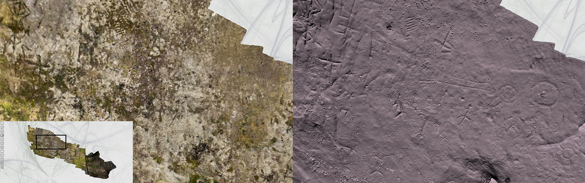
Photogrammetry model of a petroglyph panel from the Edgemont Shelter, Arkansas, published online using 3DHOP. Left image shows the model with color, with the petroglyphs obscured by heavy lichen growth; right image shows the same view of the model with the color stripped, and lighting source location adjusted to highlight the shallow topography of the petroglyphs. The additional visibility from photogrammetry, and the manipulation and viewing of the model online, speaks well to the benefits of photogrammetry and of online presentation for communication and exploration beyond what is possible in person. Lower left insert indicates where on the panel the enlarged photographs were taken, although note that the 3D model was rotated given that the petroglyphs are located on an overhang, so the bounding box does not align perfectly. Model created by Malcolm Williamson, Center for Advanced Spatial Technologies (CAST), University of Arkansas.
This review addresses spatial data as a subset of digital data, whose swift advances in archaeology are documented well in reviews over the past several years (e.g., Garstki, ed. Reference Garstki2022; Klehm and Gokee Reference Klehm and Gokee2020; Opitz and Herrmann Reference Opitz and Herrmann2018; Optiz and Limp Reference Opitz and Fred Limp2015). As archaeologists lean toward reuse and interoperability, with ethics on their minds, how to treat spatial data is of particular importance. This is because of the complexities involved at every life-cycle stage, from collection to dissemination, and because the size of spatial data not only is a challenge when approaching archiving but also raises issues with processing and visualization, among other issues. Here, the “DIY” momentum of increasingly accessible spatial methods is examined alongside forthcoming changes in publication policies (especially in the United States), framed around best practices and ethical considerations.
WHAT IS (AND WHY CARE ABOUT) SPATIAL DATA?
Spatial data refers to data generated from high-density survey and measurement (HDSM) methods: often 2.5D (which illustrates some depth of perspective) and/or digitized or digitally born 3D data that are unique in form and can be massive in size. HDSM is integral for the spatial analysis of human behavior at a very large-scale (i.e., very high resolution). Given that data are multivalent, there are multiple, interrelated analytical scales involved in understanding how humans perceive, occupy, and alter space. Obtaining this very large-scale data involves the high-density measurement and analysis of a wide array of objects, structures, sites, and landscapes. These are objects that interact with and shape the lives of people who encounter them: structures such as homes, workshops, and furnaces; burial grounds representing places of habitation and use by the living or the deceased; sites where people live, work, or travel to from afar; and landscapes with which humans interact. HDSM methods can be grouped under the umbrella of “spatial archaeometry,” or the application of archaeological scientific techniques to the study of spatial relationships (Casana Reference Casana2014). Most commonly, these would be methods such as micro-computed tomography (microCT); photogrammetry, the creation of 3D models from a series of overlapping photographs; laser scanning, be it terrestrial or airborne—commonly known as lidar; near-surface geophysical techniques; and high-resolution multispectral satellite imagery; among others. These are expanded on below. Although many good introductory guides to good practice exist (e.g., Historic England Reference England2017, Reference England2018), open-access training resources on evaluating and using archived spatial data, as with the Spatial Archaeometry Research Collaboration's GitHub (e.g., Claxton et al. Reference Claxton, Terhune and Wilson2022; Kasten Reference Kasten2020, Reference Kasten2021; Figure 2) are especially important given the increasing amount of spatial data available online.
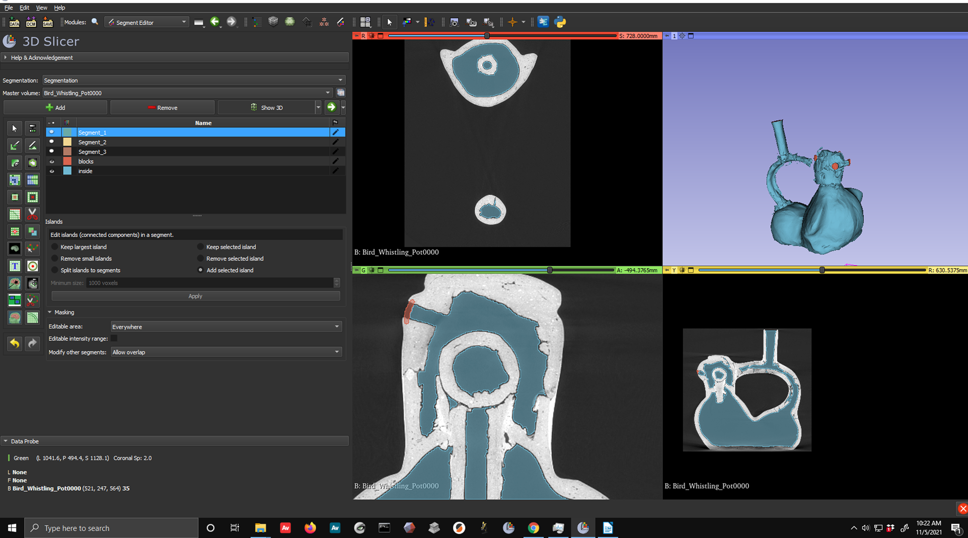
Instructional image on the loading and segmentation of 3D micro-computed tomography (microCT) data in 3D Slicer, an open-source software for the visualization, processing, and analysis of 3D CT data. This image, produced by Alexander Claxton, is part of a free exercise for archaeology students and practitioners entitled “Exploring microCT Applications in Archaeology: A SPARC Teaching Resource,” created by Alexander Claxton, Claire Terhune, and Manon Wilson (Reference Claxton, Terhune and Wilson2022). The dataset associated with the image is a Moche bird-effigy whistling pot, dating to approximately 500–750 BC, that is housed in the University of Arkansas Museum collections. The microCT scan was generated by the MICRO facility at the University of Arkansas. The full teaching resource can be found at https://github.com/castuofa/sparc_microct.
Archaeologists, as collectors and counters of things, have a bias toward thinking that more is better—additional data, higher resolution, greater number of insights—while making the most out of limited opportunities. Furthering the issue is the pressure of winnowing of budgets as other costs expand, be it the rising cost of labor, the price of owning or renting expensive equipment or software to conduct work, publishing open access, or the onus to curate (expensive) spatial data in trusted archives. With few graduate-level programs (at least in the United States) explicitly teaching ethics in data management, let alone spatial data management, training often relies on a mentorship model. This can vary significantly by person, department, and specialty—or from exposure and experience, good or bad. This is particularly problematic given the job market outlook for archaeologists in the coming decade and the need for geospatial competency among university graduates (Altschul and Klein Reference Altschul and Klein2022). It is neither a generally effective model nor a sustainable one. The problem needs to be addressed by the archaeological community and not just among spatial data specialists, given that these methods truly are becoming increasingly democratized.
SPATIAL DATA AND THE BRAVE (BOLD?) NEW WORLD OF DO-IT-YOURSELF
Recent developments in spatial analytical methods allow for higher density and more precision than ever before. The availability and sophistication of these technologies is not merely generating new data but facilitating entirely novel means of engaging with the archaeological record. In parallel, geospatial and remote sensing techniques have matured from emerging specialties to ones seen as integral and increasingly essential (Opitz and Herrmann Reference Opitz and Herrmann2018). Survey using GPS/GNSS is becoming the norm, with features and artifact data digitized and analyzed within geospatial databases (e.g., Cobb et al. Reference Cobb, Earley-Spadoni and Dames2019). Near-surface geophysics is improving our ability to target features for excavation and even detect site layouts. Aerial imaging now routinely includes data from satellite and small unmanned aerial systems (sUAS, or “drones”) platforms at increasing resolutions, whereas historical imagery finds new utility as it is integrated into geospatial platforms. Black-and-white photography has been enhanced by color, multispectral, and hyperspectral data, opening regions for study that were previously too large, dangerous, or logistically challenging to document—while also making visible smaller, more subtle archaeological and landscape features. Lidar helps detect archaeological landscapes through major impediments such as cloud and vegetation cover, aiding the discovery of entire archaeological cities otherwise obscured. Furthermore, hundreds of lidar returns per square meter are now achievable from sUAS platforms, allowing the mapping of increasingly subtle surface features with these and other sensors. The trend in lidar publications in archaeology alone speaks to the widespread interest of spatial techniques (Damien Evans maintains a downloadable bibliography dating back to 1985). Advances in machine learning and VR/AR have further resulted in improved classification and visualization (e.g., Bickler Reference Bickler2021; Liang Reference Liang2021).
Although many of these techniques still require an advanced level of training—and money—others do not necessarily. Photogrammetry, for example, is being pitched with a “do-it-yourself” level of accessibility, both with cameras and unmanned aerial vehicles (UAVs, or “drones”; Cerasoni et al. Reference Jacopo N., do Nascimento Rodrigues, Tang and Hallett2022; Magnani et al. Reference Magnani, Douglass, Schroder, Reeves and Braun2020; Marín-Buzón et al. Reference Marín-Buzón, Pérez-Romero, López-Castro, Jerbania and Manzano-Agugliaro2021; Olson and Rouse Reference Olson and Rouse2018; Figure 3). The use of portable mobile mapping systems is garnering particular excitement—what seems simpler and more familiar than just using your phone?—with iPads for photogrammetry and iPhones for lidar (Cohen-Smith et al. Reference Cohen-Smith, Bickler, Jones, Larsen and Apfel2022, Luetzenburg et al. Reference Luetzenburg, Kroon and Bjørk2021; Maset et al. Reference Maset, Riccardo Valente, Iamoni, Haider and Fusiello2022; Teppatti Losè et al. Reference Teppati Losè, Spreafico, Chiabrando and Tonolo2022). Yet, the processing decisions—let alone issues with accuracy for the objects of interest, or archiving, or access to the models or their raw data—represent a microcosm of the larger issue(s) that spatial data in archaeology face in the coming decade. Matching goals with expectations, expectations with forethought, all while preparing for unanticipated futures can be daunting and dizzying. Further, such tasks may be underappreciated or even unrecognized by peers, the academy, or employers. And, frankly, they are less fun than making a 3D model on your phone and impressing friends and colleagues.
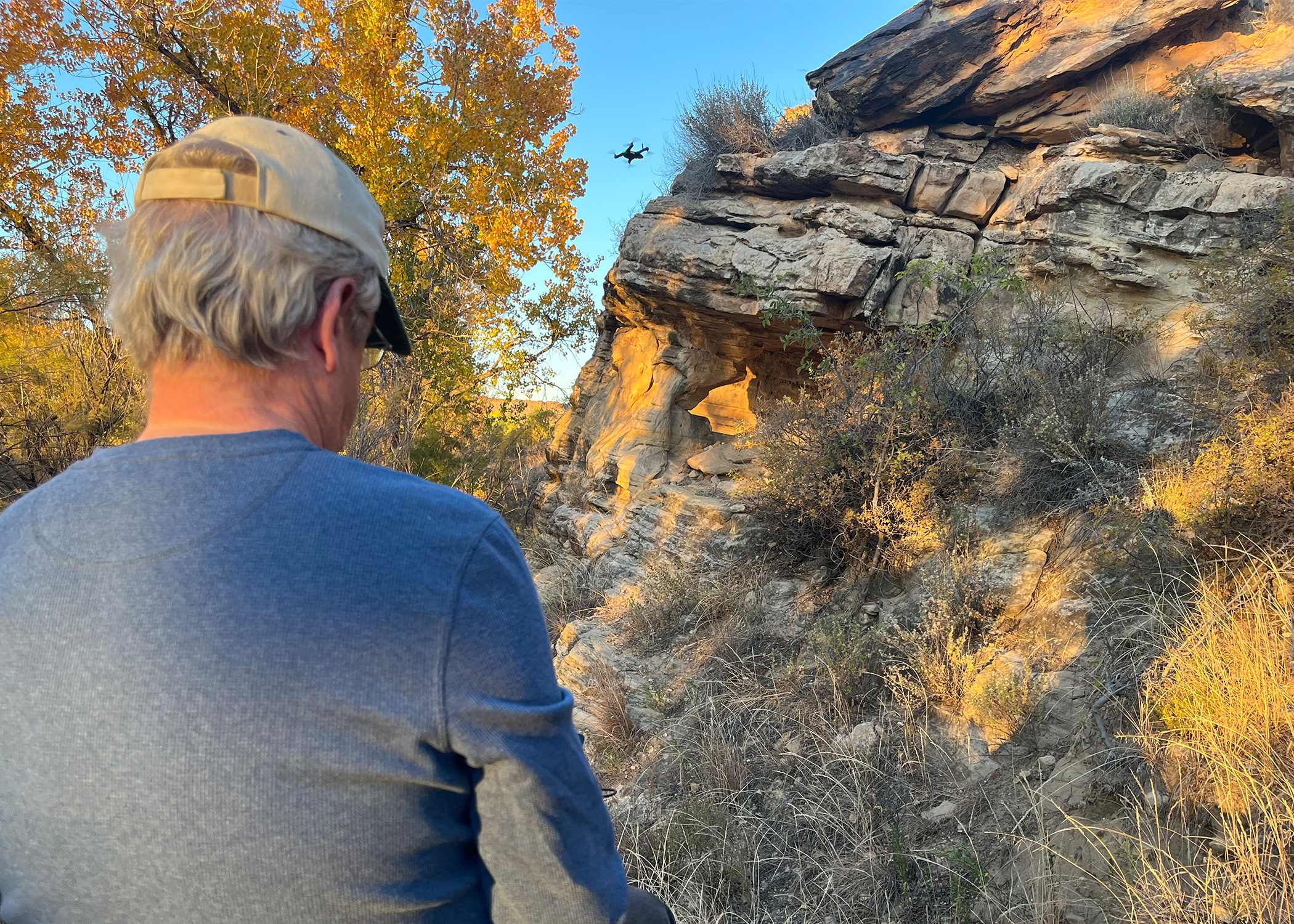
Malcolm Williamson (CAST) piloting a Skydio 2+, a small, lightweight, and relatively low-cost UAV that can be used for aerial photogrammetry. Photo from near Black Mesa, Oklahoma, taken by Carla Klehm.
The challenge with the more casual deployment of spatial archaeometric techniques comes with a double-faced Janus of trust and blindness to the producer and/or black-box decisions that are built into these platforms and software. Metadata, paradata (where the data came from and how they were processed), and descriptive data have never been more important as we evaluate their quality. Was the choice of equipment the correct one for documenting a feature of that size, color, or distance? How did processing decisions impact the model? Is the scale correct and consistent throughout the model? Where are the data located? And what are the long-term plans for their longevity and interoperability? Even when archaeologists make those choices themselves, visualizations are derivatives, and what one sees is not a neutral representation of the data. Štular and Lozic (Reference Štular and Lozic2020) provide an excellent example of how just one filter can dramatically alter the “visibility” of archaeological features. Intentional and unconscious choices impact our ability to trust and (re)produce good science. Accessibility of data and models varies widely.
SPATIAL DATA: WHY IT IS ABOUT TO GET EVEN MORE CHALLENGING
In an announcement perhaps overlooked by some, the White House's Office of Science and Technology Policy announced in August 2022 that scientific publications that result from US federal funding will need to be openly accessible as of the day they are published. How the policy will be implemented—whether there will be a requirement for publication support in each grant (“cut from the meat”), or if there will be other models—is unclear. Although this is a much-needed seismic shift in addressing (some) inequalities in access, spatial data will be thorny. Digital colonialism exists, and spatial technologies are often especially suspect, with equipment sometimes costing $100,000 or more, and software license subscriptions also in the thousands. This is without considering infrastructure limitations by those audiences one hopes to engage: Are the data suited to be viewed or used in low-resourced environments, where there is slow internet or intermittent connections? Or on aging computers or mobile phones, given that the way people access the internet regularly varies, especially across the Global South? Although there are many inequalities tied into who has access to spatial techniques, the ability to view, manipulate, and use spatial data for archaeologists and communities who are limited in resources exacerbates those differences. Publications serve both research purposes and as communication venues for multiple publics. Even if trends toward removing publication paywalls continue, publishing practices are not conducive to accommodating spatial data and the perspectives they provide (Štular Reference Štular and Garstki2022).
In the United States and beyond, there will be an increasing push toward data accessibility for both funders and the public while dealing with (and sometimes despite) stakeholders’ desires (Cohen et al. Reference Cohen, Klassen and Evans2020; Fernandez-Diaz Reference Fernandez-Diaz, Cohen, González and Fisher2018; Lim et al. Reference Lim, Gleason, Williams, Linares Matás, Marsden and Jones2022). Fostering data sovereignty requires engagement throughout the trajectory of research, and it requires creative thinking. For example, the use of satellite data and its derivatives may still fall under license agreements by the vendors, but UAVs can gather proprietary spatial data. In turn, however, it also requires additional thought for open-access processing software and visualization platforms (Lim et al. Reference Lim, Gleason, Williams, Linares Matás, Marsden and Jones2022). Archaeologists will have to continue to contend with the Sisyphean task of dealing with legacy data (with the, at times, hundreds of hands on them that came before, e.g., Harrison Reference Harrison and Garstki2022) and how that can articulate with spatial methods and spatial data. Despite an earlier implication that archaeologists are cheap and opportunistic, archaeologists can and have been creative—and inclusive. They have found ways of engaging low-resourced communities in digital storytelling and collaborative photogrammetry (Bria and Vasquez Reference Bria, Vasquez and Garstki2022), enabling citizen science that further reflects Indigenous communities’ autonomy and priorities (Lim et al. Reference Lim, Gleason, Jones and Church2021), and contending with well-meaning but off-target advocational publics online (Emmitt Reference Emmitt2022). The use of digital spaces for including Queer, feminist, Black, and Indigenous perspectives have been slowly included into digital archaeological spaces, despite limitations (Cook Reference Cook2019). The conversation about ableism in archaeology (e.g., Heath-Stout et al. Reference Heath-Stout, Kinkopf and Wilkie2022) will become increasing relevant in this conversation about not just who has access but how they can access information.
With spatial data, there exist challenges in both the funding infrastructure and the archaeology community's ability to handle the burden—or opportunity—of archiving to come. European archaeologists, under the working group SEADDA (Saving European Archaeology from the Digital Dark Age) and in tandem with COST (European Cooperation in Science and Technology), have been explicitly engaged in discussions about persistent data repositories, optimizing data for interoperability and reuse, and defining good practices for archaeology in volumes as with Richards and colleagues (Reference Richards, Jakobsson, Novák, Štular and Wright2021). Also notable in the Richards et alia volume is a single article on the state of digital archiving in the United States (Nicholson et al. Reference Nicholson, Fernandez and Irwin2021), aptly referred to in its title as “the Wild West.” Calls for better archiving of spatial data are certainly not new (e.g., Limp Reference Limp, Forte and Campana2016), but they remain salient if not more relevant than ever.
Even with 3D visualizations, or archiving of processed data, there are still elements of bottlenecks: are the metadata and paradata present, given that this is a derivative and an interpretation of the analyzed data (see reference to ADS, below)? Documentation is essential not just for use and initial understanding but for reuse. That thorn of comparative data among archaeological sites—and even at the same site between years, between excavators, or with legacy data—is and remains a huge hurdle for attempts at comparison or regional syntheses.
SPATIAL DATA: A CALL TO ARMS (AND YES, ANOTHER CALL FOR DATA MANAGEMENT PLANS)
Yes, we need data management plans. The Archaeological Data Service (ADS) remains the most comprehensive, “go to” volume for designing them. Within the Guides to Good Practice, there are specific mentions of the use of spatial archaeometric techniques. The general best practice in archiving spatial data is to first use a university or institutional archive, then a domain (e.g., archaeology-specific) archive, followed by a general-purpose archive. Kansa and Kansa (Reference Kansa and Kansa2021) point to many of these resources: Archaeological Data Service, tDAR, and Open Context, as well as more place- or method-specific platforms, such as MorphoSource. Archaeologists are getting more experimental with the use of Git and its Large File Storage (LFS), Dropbox, and Zenodo, but many come with a cost, and file size accelerates quickly. The key here is that spatial data management cannot be an afterthought; it needs to be an integral part of the budgeting process, not just for the archive itself but also for the archiving process. Formats matter immensely, with awareness of open versus proprietary file types, the choice between binary and plain texts, file compressions, and the use of lossless and lossy techniques. Often not mentioned is the added complication of archiving raw data alongside processed data to accommodate future software updates that provide expected and unforeseen new capabilities for visualization and research. Publishing processed data only limits that potential.
Resources for careful data management and guides to good practice for spatial data exist, but one must care enough to employ them. Perhaps a repackaging of their importance is due. The introduction and full volume by Garstki (ed. Reference Garstki2022), Critical Archaeology in a Digital Age, was the one I followed for my own writing here.
Kansa and Kansa's (Reference Kansa and Kansa2021) digital review in this journal on digital data and data literacy provides a good place to start for cultivating investment by the archaeological community. Instead of a checklist following a life cycle (beginning with data acquisition and followed by processing, analysis, visualization, publication, archiving, and reuse), they offer a series of questions that should resonate with archaeologists: how we want data to be used by others, integrated at a variety of scales and cross-cutting all the limitations of region-specific terminology. Relevance is something archaeologists aspire to; we want our work not to rust unused or sit behind broken links, but to make better policy, protect important places, provide insights into human nature and human pasts, and help us understand both the worlds in which we live and ourselves. More concretely, it means realizing that metadata and paradata are essential, being thoughtful in how we document (in consistent and unambiguous ways), for whom (and who is involved in that process) we document, and in what ways data will be accessed. Huggett (Reference Huggett2022) proposes an archaeological data imaginary where open research and research infrastructure holds potential but remain parts of a journey full of frictions. Whether spatial data is too big to fail, or the opposite, provides a challenge and an opportunity.
Acknowledgments
The writing of this manuscript was derived from experiences through the National Science Foundation's Spatial Archaeometry Research Collaborations (SPARC; NSF SBE#2114235) and the National Endowment for the Humanities’ Spatial Archaeology Residential and Online Institute (NEH HT-272565-20) programs. Further insight from conversations with Fred Limp, Jackson Cothren, and others at CAST honed subject material, with Limp in particular pointing out the upcoming change in federal grant policies. Limp, Kristin Landau, Jonathan Lim, and Wolfgang Alders provided insightful feedback on the drafts, as did Peter J. Cobb from the Advances in Archaeological Practice Board. Additional independent conversations about iPhones and archaeology with Emma Menio, Stan Ambrose, Cameron Monroe, and Brandi Bethke highlighted the need to engage a bit further with mobile mapping systems. The microCT GitHub training exercise used in Figure 2 was developed through SPARC (NSF SBE#2114235). The photogrammetry project at Edgemont Shelter in Figure 1 was supported by an Arkansas Historic Preservation Program grant awarded to the City of Fairfield Bay, Arkansas, with the permission of the Arkansas Archaeological Survey (ARAS).
Funding Statement
The article has been made possible in part by major grants from the National Endowment for the Humanities' Institutes for Advanced Topics in the Digital Humanities: Spatial Archaeology Residential and Online Institute (HT-272565-20) and the National Science Foundation: SPARC: Facilitating Research, Experimentation, and Education in Spatial Archaeometry (Award #2114235). Funding for Gold Open Access publication was generously provided by the Arizona Army National Guard. Any views, findings, conclusions, or recommendations expressed in this article do not necessarily represent those of the National Endowment for the Humanities nor the National Science Foundation.
Data Availability Statement
The Arkansas Archaeological Survey retains a copy of the data and the final report associated with the Edgemont Shelter petroglyph documentation. The dataset used in the microCT SPARC teaching resource can be downloaded from MorphoSource at https://www.morphosource.or/projects/000393630?locale=en.
Competing Interests
The author declares no competing interests.


 Open access