Introduction
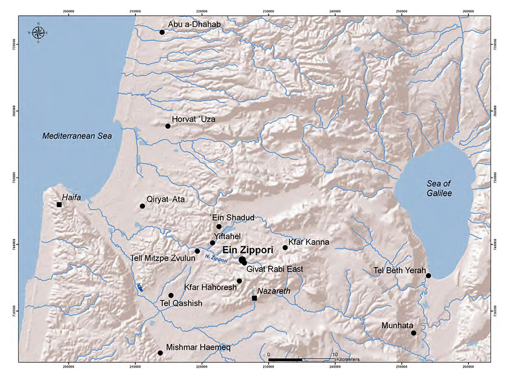
Location map.

Most of the data regarding proto-historic periods in the lower Galilee region, Israel, (Figure 1) derive from excavations at Yiftahel during the 1980s and '90s (Reference BraunBraun 1997; Garfinkel et al. 2012). These data have been valuable for comprehending the layout of the Early Bronze (EB) IA village, but shed less light on its subsequent urban phases. The development of Early Bronze Age urbanisation is better documented at other nearby sites (Barzilai et al. 2013).
Extensive salvage excavations carried out over the last five years provide new insights on the proto-historic cultures of the lower Galilee. New fieldwork has been conducted at a number of sites in the Nahal Zippori basin (e.g. Tell Mitzpe Zevulun North, Yiftahel and Kfar Qanah).
In 2011–2013, the Israel Antiquities Authority conducted a salvage project at Ein Zippori, c. 2km west of Nazareth, in preparation for the widening of Highway 79. The site is located between the hill of Giv'at Rabi and the stream and springs of Nahal Zippori. Excavation indicates the site was occupied during the Pre-Pottery Neolithic (PPNB) B–C (eighth-ninth millennia BC), the Early Chalcolithic (sixth–fifth millennia BC) and the EB IB and II (end of fourth millennium–beginning of third millennium BC). Sporadic finds of Roman and Byzantine date were also found, connecting the area with Zippori (Sephoris). Finds from the Crusades period confirm reports that Frankish soldiers camped at this site before the Battle of Hattim (AD 1187) against Salah Ad-Din.
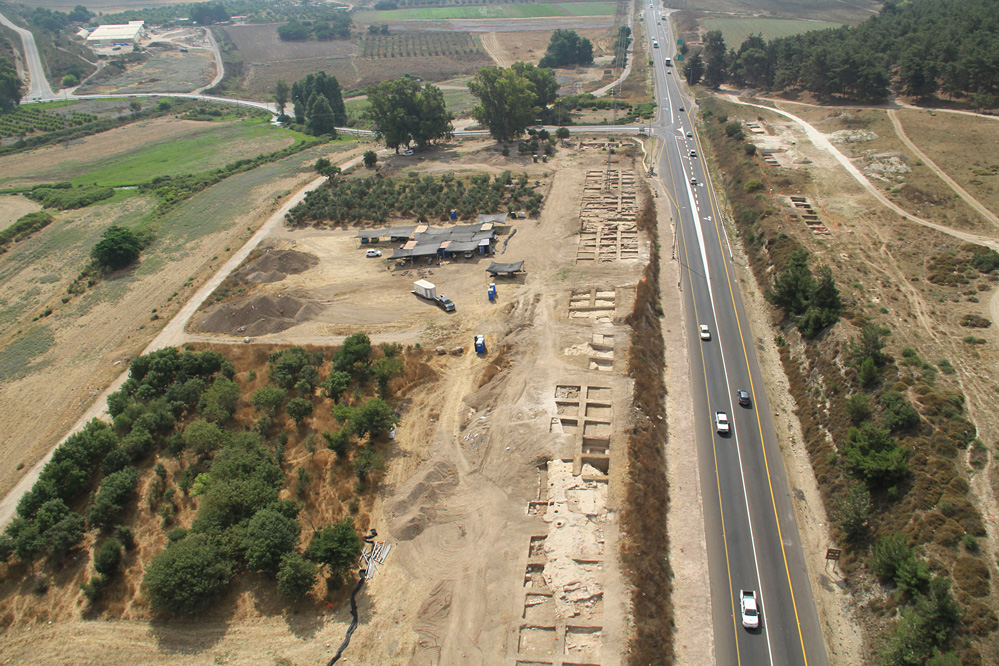
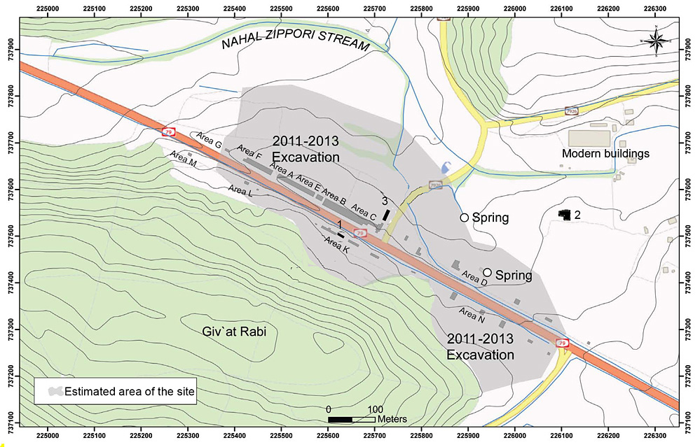
A total of c. 500m² was excavated across 11 areas (Figure 2). The architectural remains of the EB IB (3300–3000 BC) were restricted to the western and central areas (Figure 3) with building remains accumulated in three or four strata.
General view of the site, looking east.

Location of excavated areas (2011–2013) and estimated site. 1) 1995 excavations; 2) Tel Ein Zippori excavations; 3) 2007 excavations.

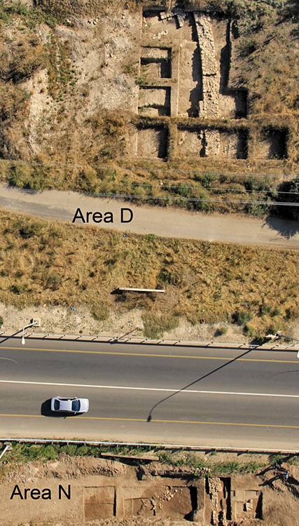
Aerial view of the town wall, looking north.

The EB IB town
In areas D and N, a wall (Figure 4) protected the eastern side of the EB IB town. A narrow passage (poterna) through this wall was located in area D, as well as a house attached to the wall's inner face. The base of the town wall (c. 2m wide) was built of large roughly dressed stones, while the superstructure probably consisted of mudbrick. Magnetometry survey suggests that, just north of area D, the wall turns to the west, following the wadi, to protect the north side of the town.
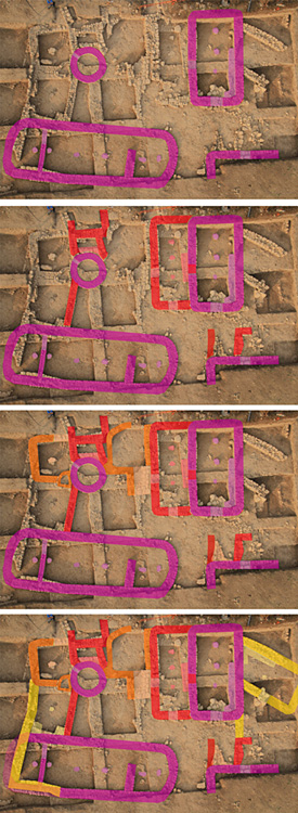
The EB IB houses were constructed of roughly dressed field stones laid in courses as foundations for mudbrick walls. The internal wall faces were plastered with mud, as revealed in Area G. Several strata were found, with a number of phases in each (Figure 5). Roofs were supported by wooden columns positioned on stone slabs along the central axis of the houses. Uniformly modular distances between the supporting columns and the walls show that beams were between 2.3 and 2.6m long. Earth-packed floors were originally below the foundation levels, but later renovations often raised the floor levels. Several houses and outdoor spaces had partial stone-slab paving, perhaps hinting at some special significance.
Aerial view with phasing of EB IB buildings in Area B (looking south); from early (purple) to late (yellow) and intermediate stages (red and orange).

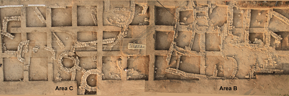
Two building types were simultaneously in use: long buildings of parallel side walls with round partitioned apses at each end, and rectangular buildings with rounded corners. The former type seems to be present only in the earlier strata. The latter type forms the majority of the excavated structures. In time, rooms were added to the initial buildings, closing and opening doorways according to need, creating building clusters and, eventually, forming a dense urban fabric.
Several circular small stone-lined pits were discovered. These features—probably silos—date to the EB IB and are located between the building clusters. They have maximum diameters of 0.9–1.1m. In area C, a pair of impressive circular structures was discovered attached to houses belonging to the later EB IB stratum. These structures are c. 4.0m in diameter, and have relatively large foundations, 0.8m wide, made of roughly dressed stones. Together they define a narrow gateway into the domestic area, possibly functioning as a look-out post (Figure 6).
EB IB finds
Aerial view of buildings in area B and C.

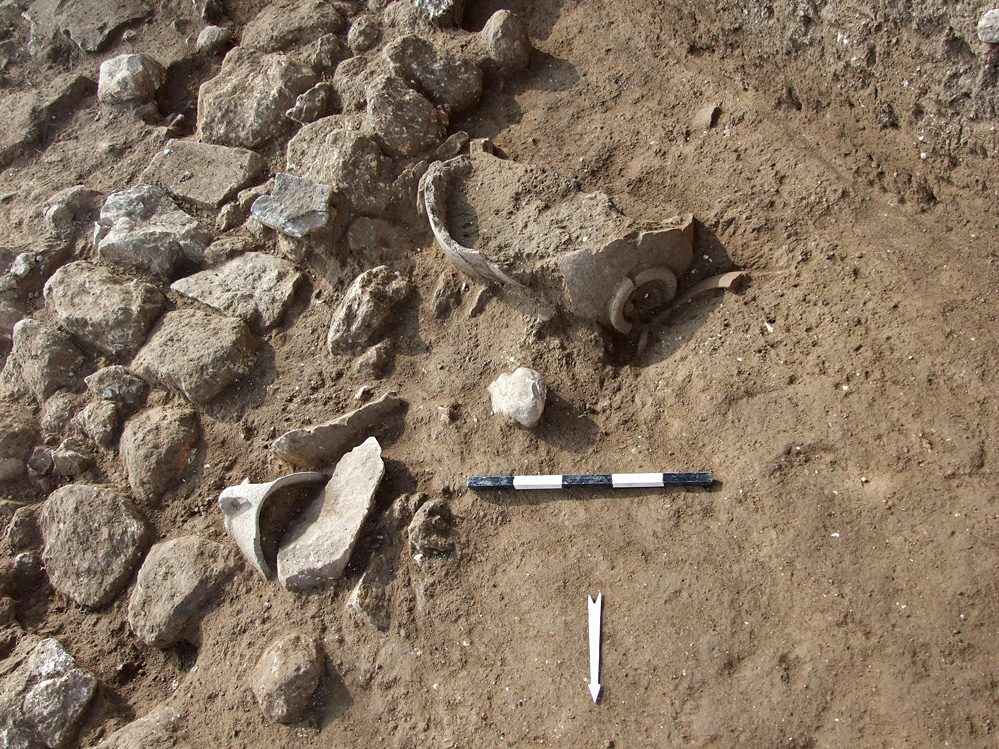
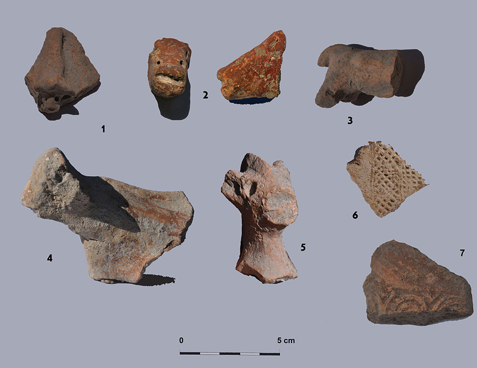
The artefacts associated with the EB IB strata at Ein Zippori are concurrent with the period's final phase (e.g. Figure 7). Among the pottery found are 'Crackled Ware' bowls and pithoi with thickened incised 'rail rims' characteristic of the eastern Galilee and northern Jordan valley. The main decoration is the so called 'grain wash'—whitewashed lines splashed on the surface of the vessels. There were also a small number of bowed rim jars, as a well as few 'Grey Burnished Ware' bowls of the late type 3, more common in the Jezreel valley and the western Galilee (Reference MilevskiMilevski 2011). Among the stone artefacts were numerous basalt bowls with four handles and several basalt pivots for potting wheels. Flint items include typical Canaanean blades. Zoomorphic figurines and seal impressions on pottery sherds (Figure 8) were also found.
EB IB pottery and basalt vessels found in situ, Area L.

Figurines (1–5) and seal impressions (6–7).

Discussion
The 2011–2013 excavations at Ein Zippori have revealed a walled town of the late phase of the EB IB in the Nahal Zippori basin, probably connected with the EB I–II site at the summit of Giv'at Rabi. The gradual densification of occupation and the presence of a town wall point to an early wave of urbanisation and fortification in the southern Levant, which is also observed at Tel Bet Yerah (Reference GetzovGetzov 2006), Tel Shalem (Eisenbeg 1996) and probably at Tel Afek (Kochavi et al. 2000), 'Ai (Reference CallawayCallaway 1980) and Tel Erani (Yeivin 1972). The material culture indicates how EB IB Ein Zippori was broadly connected to both west and east, mostly with the sites of Lake Kinneret and the northern Jordan valley.
After Yiftahel, Zebulun North and probably Qana, Ein Zippori was the largest of the EB sites in the Nahal Zippori basin. Excavations here have contributed to understanding of the significant changes which occurred during the EB I in this region: village populations grew, defensive walls were built, and towns or cities began to develop.
Acknowledgements
The authors wish to thank field supervisors Fadi Abu Zidan, Enno Brun, Maayan Shemer, Ariel Vered and Omar Zidan for their invaluable help in the field. They are also indebted to Heeli Shechter, Lena Brailovsky, Omry Barzilai, Hamudi Khalaily and Ofer Marder (lithic assemblages), Sonia Itkis (magnetometry) and to Rivka Mishayev and Mendel Kahan (plans and sections). Thanks are also due to workers from Kfar Manda, Nazareth, Iblin, Shefaram and Tiberias. Pictures and illustrations are courtesy of the Israel Antiquities Authority.