The salt spring near the village of Moriez, south-west of Digne and to the north-east of Barrême in the Alpes-de-Haute-Provence (France) (Figure 1), is located in the southern subalpine chains, at the junction of two overthrusted units: the Digne nappe and the Castellane foldthrust belt. The local geology consists of a group of strike-slip faults evolving sometimes into overthrusts in its southern parts. Close to the site, Pleistocene formations rise to ground level. Triassic evaporite layers correspond to different levels of removal from deposits and thrusts (Figure 2). Artefacts found at the salt spring of Moriez were removed from these Triassic evaporitic formations: a shaft was dug into them, in the alluvial deposits of a torrent. The upper Cretaceous, overlapping the gypsum deposits and the Jurassic located beneath, cover a large mass of evaporites containing halite which is responsible for the mineralisation of the water. It infiltrated into the surrounding massif, drained by fractures leading south or south-west as far as the junction of the fault lines which block the movement of water further afield. Analyses indicate that the water contained high levels of sodium chloride, and reveals great variations in total mineralization, from 9100 to 143000 mg/l, with more than 48000 mg/l of sodium chloride. Concentrations of major ions and trace elements confirm deep leaching from evaporitic layers.
Geographical location of the Moriez shaft in France, in the region of Provence-Alpes du Sud, and a simplified structural schema of Haute-Provence. 1: the shaft of Moriez; 2: faults; 3: overlappings; 4: Valensole conglomerates (the Mio-Pliocene basin of Digne-Valensole); 5: Eocene-Oligocene continental formations (basin of Aix-Manosque); 6: Jurassic and Cretaceous formations (+ small tertiary basins not shown on the map). (Diagram: Myette Guiomar).

Top: geological map of the surroundings of the Moriez shaft, after the geological map at 1/50,000, feuille de Digne, modified. Bottom: simplified geological section of the right bank of the Asse de Moriez, uphill from the salt water shaft. The colours used are the same as those used on the geological map. (Section: Myette Guiomar).

The village of Moriez claimed, in the fourteenth century, the right to exploit freely its salt spring; such a right was granted by Queen Jeanne, sovereign of the Comté de Provence, in a decree of Aix in 1672. At this time the salt water of Moriez was used indirectly for domestic needs. During the nineteenth century, salt was produced at Moriez, as buildings designed for such a purpose are mentioned (Figures 3-4). To solve the problem of who owned control over the resource, the administration closed the shaft. Exploitation rights remained in the hands of the administration, which proceeded to distribute salt water once or twice a week, on condition that the inhabitants accepted to pay a tax.
Panoramic view of the surroundings of the shaft of Moriez with the principal visible faults traced in red. (Photo: Myette Guiomar).

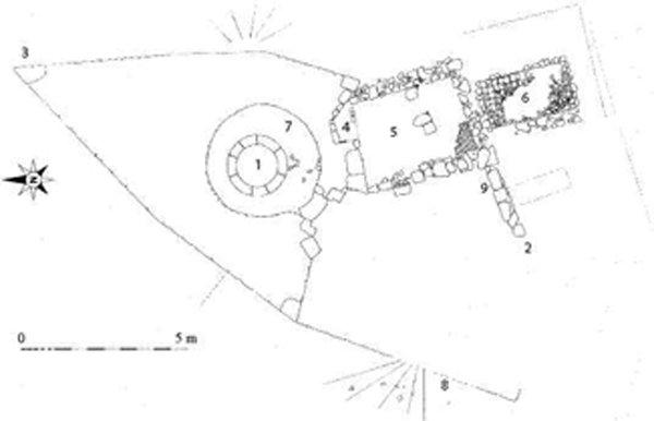
Moriez: general topography of the site and distribution of different structures. (Topography: D. Morin & M. Courgey). UA 01: Shaft. UA 02: Dike (contemporary). UA 03: Spur. UA 04: Fireplace. UA 05: Warming room? (unexcavated). UA 06: Tiled cistern (partially excavated). UA 07: Shaft room. UA 08: Retaining wall. UA 09: Thalweg partly lined with stones (contemporary).

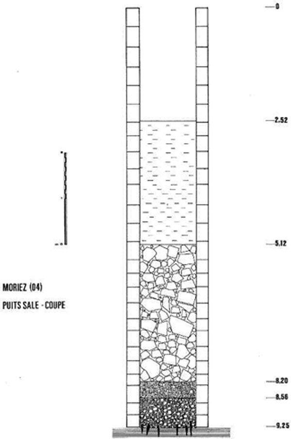
In 1998-1999, archaeological excavations took place in the interior of the shaft, which is in the centre of a circular room built of limestone (Figures 5 & 6). At the bottom, at a depth of 9.2m and a few centimetres below the base of the foundations, several fragments of wood were discovered, stuck vertically into a detritic sediment of gravel packed in compact clay (Figure 7). These small stakes, split in their upper part, were disposed at equal distances from each other (Figure 8).
Twelve of these artefacts were discovered, and six of them were studied and dated. Wood samples were taken for 14C dating at the Laboratoire des Sciences, du Climat et de l'Environnement and at the Laboratoire Souterrain de Modane (Fontugne et al. 1994).
Moriez: view of the site from the west, the surrounding stone wall that protects the shaft, and the monumental entrance (Photograph: D. Morin).

Moriez: View of the site from inside the drystone wall. (Photograph: D. Morin).

The results are as follows:
- Gif-11014: 6845 ± 65 years BP (5841, 5624 BC), δ13C= -25.29%- Gif/LSM-11015: 6745 ±45 years BP, (5725, 5561 BC), δ13C = -25.17%
These results allow us to hypothesise that the pieces of wood are contemporary and may have an average age of 6795 ± 40 years BP (calibrated dates 5735, 5624 BC). These dates are among the oldest in Europe, and are comparable to those obtained for the salt extraction sites of Lunca-Poiana Slatinii in Romania, recently dated to the Cucuteni culture.
The twelve small stakes discovered at the bottom of the shaft are all of pine. Wood faces show obvious signs of fashioning on six remaining fragments (Figure 9). Marks from splitting tools are perfectly visible. Certain wood faces are clearly defined on a macroscopic scale. The twelve fragments are all of sub-circular section, cut from so-called bois de brin (wood from twigs or branches). Eleven fragments measure 12cm in length, and ten of them have diameters ranging from 1.5 to 2cm; the eleventh is of a diameter of around one centimetre. The twelfth has an identical diameter, but it measures 9cm in length, and it seems that it was broken post-depositionally.
Moriez: stratigraphic section of the shaft (Drawing: D. Morin, Morin-Hamon).

Moriez; the shaft bottom. The sticks, being pointed at by the person on the left, can be clearly seen. The artefacts are sunk into the highly salty clay sediment levels, beneath the first level of modern foundations. (Photograph: D. Morin).

These very similar proportions, dimensions and sizes bring to mind a small structure made up of homogeneous parts. It is likely that at least two long branches were cut in a regular fashion, one of a diameter of about 2cm, the other of about 1cm. About 20 rings of relatively equal size can be distinguished in section. The three fragments with traces of splitting best show the process followed. Three successive steps characterise the preparation and placing of the distal extremities. The distal part was first sharpened to a point on two faces so as to obtain a dihedral. The bark was then removed in a single movement along the two opposing surfaces. Finally, these two sections were re-sharpened by sub-parallel and linear removal.
The points are all located along the longitudinal axis. The cutting plane of the proximal part is slightly oblique. Cutting is limited to a single surface, along a unipolar mode. The surface nevertheless presents the obvious signs of pounding due to forcing the artefact into the ground. The total length of the stakes is unknown. However, a regular spatial pattern can be detected: they are set in the ground at equal distances from each other, and their dimensions below ground level are nearly equal, indicating that calculated and identical movements were carried out. Gestures would therefore have to be shaft considered, and result from an acquired technical tradition. Finally, pinewood was consciously chosen, although there does not seem to have been any material constraint.
The stakes may be the remains of older structures devoted to salt extraction, interpreted as a structure for collecting salt by a mesh system, using interlaced branches, perhaps the remains of a tank or supports for evaporation structures.
The examination of the wood resulted in an interpretation of reasoned actions, which confer upon these vestiges the status of one among the oldest salt extraction sites known in Europe. Although partial, this information also brings to light a previously unknown aspect of the implementation of a process in the evolution of wood working techniques in Europe over these last eight millennia.
Moriez: details of the three stakes (a, b and c), presenting obvious signs of traces of blade-type splitting tools: the white traces show their limits and their contours; the arrows show the direction of the cutting. The last stake (d) shows the difficulties of interpretation due to the splitting of the distal part (right) and the coating of salt penetrating the fibres. In the centre the drawing shows the interpretation of the three-step operating process.