


Introduction
Central Mexico is a region shaped by the volcanoes of the Trans-Mexican Volcanic Belt (TMVB), which is oriented east to west. This magmatic arc (Figure 1) hosts numerous volcanic structures of different types, including polygenetic volcanoes, such as stratovolcanoes, calderas, and shields, as well as monogenetic structures, such as scoria cones, lava flows, and maars, but also domes and shields (Demant Reference Demant1978; Gómez-Tuena et al. Reference Gómez-Tuena, Orozco-Esquivel and Ferrari2005). Despite their large number, only a few stratovolcanoes are presently considered active, and on just two occasions have people had the opportunity to witness the birth of a new volcano in recent times. These were the monogenetic eruptions of Jorullo in 1759 (Gadow Reference Gadow1930) and Paricutin in 1943 (Luhr and Simkin Reference Luhr and Simkin1993), both in the west-central part of the TMVB in Michoacán (Figure 2). The Paricutin eruption started on 20 February 1943 in a cornfield and ended more than nine years later in 1952 (Luhr and Simkin Reference Luhr and Simkin1993). It formed the Paricutin scoria cone and associated lava flow field, covering an area of 25 km2, with 1.7 km3 of andesite magma (Larrea et al. Reference Larrea, Salinas, Widom, Siebe and Abbitt2017). Close observation of the eruption by scientists, almost since its birth, was unprecedented and allowed us to better understand the origin, eruption dynamics, and evolution of monogenetic scoria cones and lava flows. Almost 200 years earlier and not far from Paricutin, the eruption of the Jorullo alignment of scoria cones and associated lava flow field started in 1759 and ended in 1774, erupting 0.9 km3 of basaltic andesite magma that destroyed a large hacienda and adjacent sugarcane fields (Guilbaud et al. Reference Guilbaud, Siebe, Layer, Salinas, Castro-Govea, Garduño-Monroy and Le Corvec2011; Rowland et al. Reference Rowland, Jurado-Chichay, Ernst, Walker, Thordarson, Self, Larsen, Rowland and Hoskuldsson2009). Although Jorullo was only observed by laymen (geological science was still in its infancy), both cases are important because they allowed direct observations by multiple eyewitnesses recorded in numerous historical documents. The case of Paricutin, for which extensive photographic records, including film materials, exist (see Luhr and Simkin Reference Luhr and Simkin1993), is particularly enlightening with regard to the general understanding of the eruption of monogenetic scoria cones, including their eruption dynamics (e.g., Strombolian ash fallout and lava flow advance and velocity), eruption duration, impact on nearby populations and their economic activity, and the relocation of towns and recovery of the environment in the aftermath of the eruption (Nolan Reference Nolan, Sheets and Grayson1979). However, older, prehistoric eruptions that also impacted human settlements in Michoacán were never documented and it is impossible to know exactly how they unfolded. However, these eruptions can be roughly reconstructed by applying geological methods (e.g., stratigraphy, radiometric dating, chemical and morphological analyses, rheological calculations of eruptions times; see Chevrel et al. Reference Chevrel, Siebe, Guilbaud and Salinas2016a, Reference Chevrel, Guilbaud and Siebe2016b; Ramírez-Uribe et al. Reference Ramírez-Uribe, Siebe, Chevrel and Fisher2021; Reyes-Guzmán et al. Reference Reyes-Guzmán, Siebe, Chevrel, Guilbaud, Salinas and Layer2018, Reference Reyes-Guzmán, Siebe, Chevrel and Pereira2021), and the results obtained can then be matched to the archaeological record.
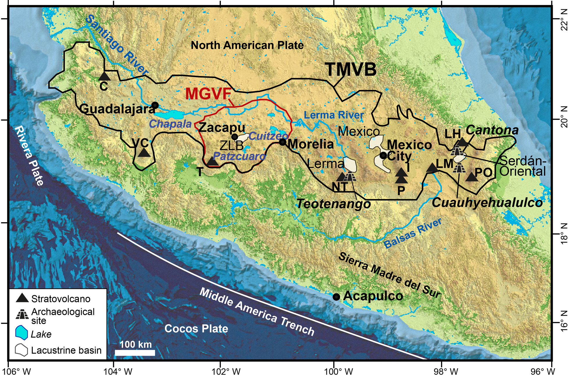
Map of central Mexico showing the location of the Trans-Mexican Volcanic Belt (black polygon), the Michoacan-Guanajuato Volcanic Field (red polygon), and the main cities (black dot), lacustrine basins, and archaeological sites. Principal lakes (in blue italic), and stratovolcanoes are also indicated: C = Ceboruco, VC = Volcán de Colima, T = Tancítaro, NT = Nevado de Toluca, I = Iztaccíhuatl, P = Popocatépetl, LM = La Malinche, PO = Pico de Orizaba, LH = Los Humeros. Base map retrieved from the Territorio insular tool (1:50,000), courtesy of INEGI (https://www.inegi.org.mx/temas/territorioinsular/).
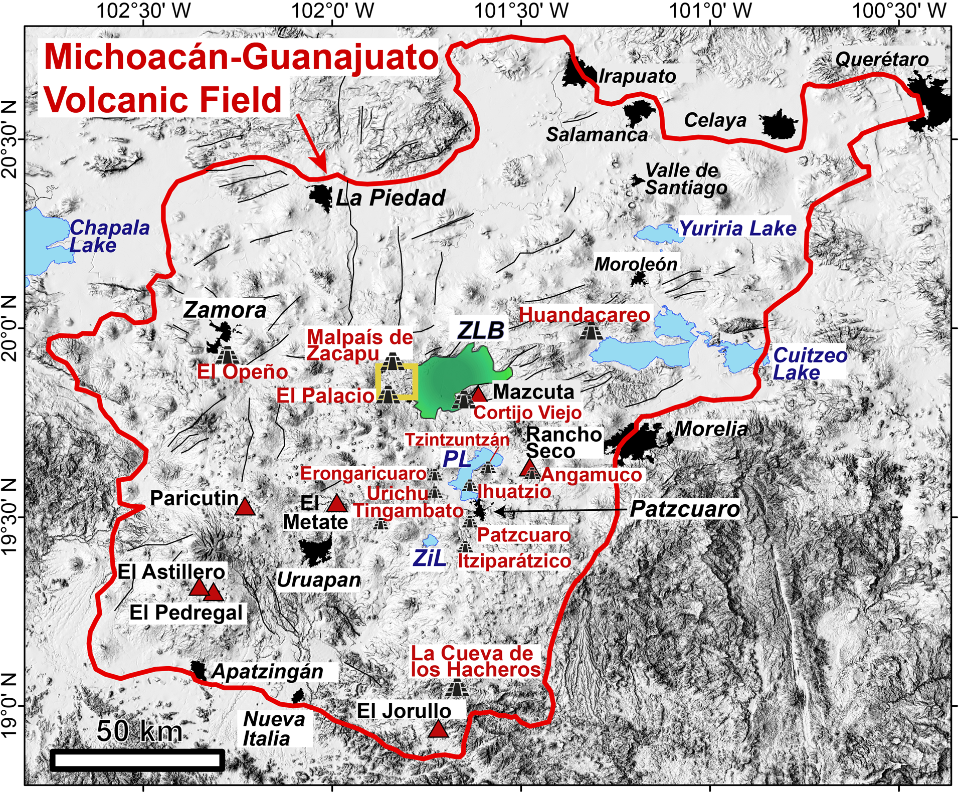
Hill-shaded digital elevation model by INEGI (https://www.inegi.org.mx/temas/territorioinsular/) of the Michoacan-Guanajuato Volcanic Field (outlined in red), showing lakes (in blue; ZiL = Zirahuén Lake, PL = Patzcuaro Lake), the Zacapu lacustrine basin (ZLB, in green), the main Holocene volcanoes mentioned in this study (red triangles, black font), major faults (black lines), principal cities (black polygons and italic black font), and archaeological sites (pyramid symbols and red font). The yellow quadrangle indicates the western Zacapu lacustrine basin area presented in Figure 4.
However, monogenetic eruptions are quite varied in terms of their eruption style and dynamics, duration, composition, volume, and so on (Németh and Kereszturi Reference Németh and Kereszturi2015). Those similar to Paricutin begin in a violent, explosive, Strombolian fashion, with the emission of fragmented gas-rich magma. The larger fragments fall out around the vent, where they accumulate, building a scoria cone, while the finer particles (sand- and silt-sized ash) are dispersed much further by the wind. This explosive phase is then followed by the effusive emplacement of lava flows, consisting of partly degassed molten rock at high temperatures (~800–1200°C; James et al. Reference James, Lane, Houghton, Fagents, Gregg and Lopes2012). Monogenetic eruptions can also occur in a purely effusive fashion, where the magma slowly ascends in a dike and partly degasses before reaching the Earth's surface (Connor and Conway Reference Connor, Conway and Sigurdsson2000; Németh et al. Reference Németh, Carrasco-Núñez, Aranda-Gómez and Smith2017). Monogenetic eruptions can last from weeks to years, and emitted magma volumes can vary by several orders of magnitude (0.001 to 10 km3), covering from tens to hundreds of km2 of land (Németh and Kereszturi Reference Németh and Kereszturi2015). Once the eruption ceases, the landscape will have changed dramatically. The eruptions of Paricutin and Jorullo showed that small monogenetic volcanoes can have severe and long-lasting effects, and even devastate entire villages, forcing their inhabitants to migrate and relocate elsewhere (Nolan Reference Nolan, Sheets and Grayson1979).
The abundance of monogenetic structures in Michoacan is of interest with regard to the past and future impacts of these eruptions on population and infrastructure. Although the hazards associated with these eruptions have not yet been sufficiently assessed, recent studies have shown that earlier eruptions might have impacted prehistoric populations in Michoacan (Chevrel et al. Reference Chevrel, Siebe, Guilbaud and Salinas2016a, Reference Chevrel, Guilbaud and Siebe2016b; Guilbaud et al. Reference Guilbaud, Siebe, Layer and Salinas2012; Larrea et al. Reference Larrea, Salinas, Widom, Siebe and Abbitt2017, Reference Larrea, Widom, Siebe, Salinas and Kuentz2019a, 2019b; Ramírez-Uribe et al. Reference Ramírez-Uribe, Siebe, Salinas, Guilbaud, Layer and Benowitz2019, Reference Ramírez-Uribe, Siebe, Chevrel and Fisher2021; Reyes-Guzmán et al. Reference Reyes-Guzmán, Siebe, Chevrel, Guilbaud, Salinas and Layer2018, Reference Reyes-Guzmán, Siebe, Chevrel and Pereira2021).
In the present study, we focus on a Late Holocene cluster of four monogenetic volcanoes that formed the Malpaís de Zacapu at the western margin of the Zacapu lacustrine basin, which is situated in the heart of the native Purepecha province (Figure 2). Recent studies (Mahgoub et al. Reference Mahgoub, Reyes-Guzmán, Böhnel, Siebe, Pereira and Dorison2018; Reyes-Guzmán et al. Reference Reyes-Guzmán, Siebe, Chevrel, Guilbaud, Salinas and Layer2018, Reference Reyes-Guzmán, Siebe, Chevrel and Pereira2021) have elucidated the age and dynamics of the eruptions, as well as the rheological characteristics of the different lava flows of the Malpaís de Zacapu and their emplacement durations. Here we present a summary of their findings and relate them to the archaeological record to better constrain the periods of occupancy and lifestyle adaptations of the people who lived on the lava surfaces and their surroundings (Arnauld and Faugère-Kalfon Reference Arnauld and Faugère-Kalfon1998; Arnauld et al. Reference Arnauld, Carot and Fauvet-Berthelot1993; Dorison Reference Dorison2019; Faugère Reference Faugère2006; Michelet Reference Michelet1993; Michelet et al. Reference Michelet, Arnauld and Fauvet-Berthelot1989; Pereira et al. Reference Pereira, Forest, Jadot, Darras, Arnauld, Beekman and Pereira2021). A better understanding of the relationship between the history of human occupation and the Malpaís de Zacapu eruptions might also be of help in mitigating the impact of future eruptions in this region.
Geological context
The TMVB is an active volcanic arc related to the subduction of the Cocos and Rivera plates underneath the North American Plate along the Middle American Trench (Demant Reference Demant1978; Gómez-Tuena et al. Reference Gómez-Tuena, Orozco-Esquivel and Ferrari2005). It crosses the country from west to east and traverses the Mexican Altiplano, a highland characterized by active normal faulting (Johnson and Harrison Reference Johnson and Harrison1990) and horst-and-graben structures that resulted in the formation of basins often occupied by broad shallow lakes, such as the Patzcuaro, Cuitzeo, and Chapala lakes (Figure 1). The basins of Mexico, Upper Lerma, Serdán-Oriental, and Zacapu were also formerly occupied by large lakes, but these were, to the largest extent, artificially drained in historic times (Figure 1; e.g., Noriega and Noriega Reference Noriega and Noriega1923).
The highest concentration of monogenetic volcanoes in the TMVB occurs in the Michoacán-Guanajuato volcanic field (MGVF; Figure 2; Hasenaka and Carmichael Reference Hasenaka and Carmichael1985a), which is the largest monogenetic volcanic field in the world related to a subduction tectonic setting (Valentine and Connor Reference Valentine, Connor, Sigurdsson, Houghton, McNutt, Rymer and Stix2015). The MGVF covers an area of ~40,000 km2, hosting >1,400 volcanic structures that are younger than 5 Ma, and includes medium-sized shields, domes, scoria cones, viscous lava flows, phreatomagmatic craters, and two inactive stratovolcanoes (Guilbaud et al. Reference Guilbaud, Siebe, Layer, Salinas, Castro-Govea, Garduño-Monroy and Le Corvec2011, Reference Guilbaud, Siebe, Layer and Salinas2012, 2019; Hasenaka Reference Hasenaka1994; Hasenaka and Carmichael Reference Hasenaka and Carmichael1985a, Reference Hasenaka and Carmichael1985b; Ownby et al. Reference Ownby, Delgado-Granados, Lange and Hall2007; Siebe et al. Reference Siebe, Guilbaud, Salinas, Kshirsagar, Chevrel, De la Fuente, Hernández-Jiménez and Godínez2014). The exact causes behind the high density of monogenetic volcanoes in the MGVF, where the TMVB is also widest, are still poorly understood, but it has been proposed that the peculiar geometric configuration of the subduction zone controls the location and size of magma generation areas and the magnitude of crustal extension (Johnson et al. Reference Johnson, Wallace, Granados, Manea, Kent, Bindeman and Donegan2009; Pardo and Suárez Reference Pardo and Suárez1995). Accordingly, the large number of monogenetic volcanoes in the MGVF is the result of partial hydrous melting of the mantle wedge, in conjunction with a flat position of the subducted plate at a depth of 90–120 km along this segment of the volcanic arc (Carmichael Reference Carmichael2002; Guilbaud et al. Reference Guilbaud, Siebe, Widom, Rasoazanamparany, Salinas and Castro-Govea2019; Kim et al. Reference Kim, Miller, Pearce and Clayton2012).
The Zacapu lacustrine basin
The Zacapu lacustrine basin (ZLB), located in the north-central part of the MGVF (Figure 2), is an active tectonic graben related to the Cuitzeo normal fault system (Johnson and Harrison Reference Johnson and Harrison1990). It comprises a total catchment area of ~1480 km2 (Figure 3), but only ~260 km2 of these (the lowest parts at ~1980 m asl) were occupied by a shallow lake (~14 m maximum depth; Kshirsagar et al. Reference Kshirsagar, Siebe, Guilbaud and Salinas2015). Paleoclimatic investigations (Lozano-García and Xelhuantzin-López Reference Lozano-García and Xelhuantzi-López1997; Metcalfe Reference Metcalfe1995; Pétrequin Reference Pétrequin1994) have revealed that conditions around the ZLB became warmer and wetter during the Late Pleistocene and Holocene, causing significant variations in the lake level. This lake was artificially drained in the early twentieth century to gain land for agricultural purposes (Noriega and Noriega Reference Noriega and Noriega1923).
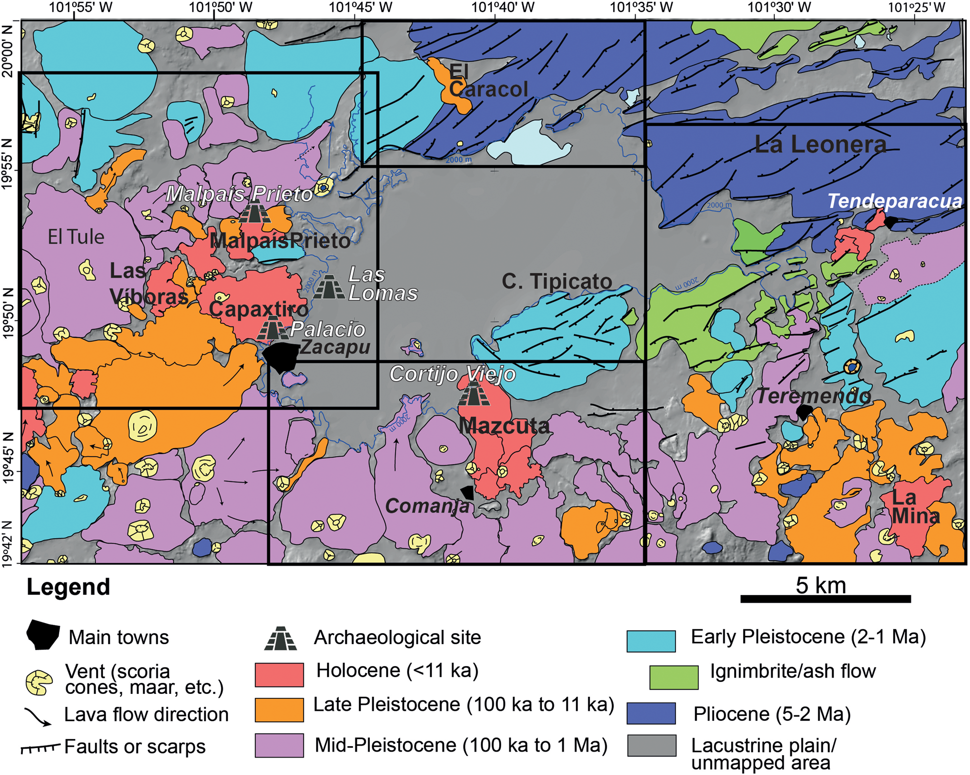
Geological map of the Zacapu lacustrine basin (color-coded according to ages), modified after Guilbaud et al. Reference Guilbaud, Hernández-Jiménez, Siebe and Salinas2021. Black quadrangles delimit the areas previously studied in detail: Western quadrangle (shown in Figure 4) originally mapped by Reyes-Guzmán et al. (Reference Reyes-Guzmán, Siebe, Chevrel, Guilbaud, Salinas and Layer2018); southern quadrangle by Ramírez-Uribe et al. (Reference Ramírez-Uribe, Siebe, Salinas, Guilbaud, Layer and Benowitz2019); eastern quadrangle by Kshirsagar et al. (Reference Kshirsagar, Siebe, Guilbaud and Salinas2015); and northern quadrangle by Kshirsagar et al. (Reference Kshirsagar, Siebe, Guilbaud and Salinas2016). See original references for radiometric ages. Main archaeological sites are indicated. Background is the hill-shaded digital elevation model by INEGI (https://www.inegi.org.mx/temas/territorioinsular/).
The ZLB has experienced intense tectonic and volcanic activity since at least 3 Ma ago (Demant Reference Demant and Michelet1992), which has repeatedly modified the basin, forcing the lake's shore to shift. The geological units around the ZLB are entirely volcanic and basaltic andesite, trachyandesite to dacite in composition (Figure 3). The oldest unit is located in the northeastern part of the ZLB and corresponds to La Leonera volcano, dated at ~4.6 Ma by the 40Ar/39Ar method, while the youngest feature in this part is the Tendeparacua lava flow, dated at ~5000 b.c. by the radiocarbon method (Kshirsagar et al. Reference Kshirsagar, Siebe, Guilbaud and Salinas2015, Reference Kshirsagar, Siebe, Guilbaud and Salinas2016). To the southeast of the basin, ~20 volcanic structures have been mapped (Figure 3) and dated, yielding Early Pleistocene to Holocene (~6000 b.c.; La Mina scoria cone) ages (Kshirsagar et al. Reference Kshirsagar, Siebe, Guilbaud and Salinas2015). In the southern part of the ZLB, 36 volcanic structures younger than ~1.5 Ma were identified over an area of ~500 km2, with an erupted volume of ~25 km3 (Ramírez-Uribe et al. Reference Ramírez-Uribe, Siebe, Salinas, Guilbaud, Layer and Benowitz2019). In this part, the youngest volcano, dated at ~7000 b.c., is the Mazcuta scoria cone and associated lava flows. Its distal lavas reach into the lacustrine plain, where they host the Cortijo Viejo archaeological site (Figure 3; Ramírez-Uribe et al. Reference Ramírez-Uribe, Siebe, Salinas, Guilbaud, Layer and Benowitz2019).
Finally, the western margin of the ZLB encompasses 47 volcanic structures, which represent a volume of ~50 km3 of lava and cover an area of ~400 km2 (Figure 4; Reyes-Guzmán et al. Reference Reyes-Guzmán, Siebe, Chevrel, Guilbaud, Salinas and Layer2018). In this area, the oldest volcanic rocks are encountered at Mesa El Pinal (~2 Ma), while the youngest structures are the four volcanoes that comprise the Malpaís de Zacapu (Reyes-Guzmán et al. Reference Reyes-Guzmán, Siebe, Chevrel, Guilbaud, Salinas and Layer2018).
Geological map of the western Zacapu lacustrine basin, modified after Reyes-Guzmán et al. (Reference Reyes-Guzmán, Siebe, Chevrel, Guilbaud, Salinas and Layer2018). The white quadrangle indicates the area covered by the Malpaís de Zacapu lava flows (Figures 5 and 7). Holocene dates from Mahgoub et al. (Reference Mahgoub, Reyes-Guzmán, Böhnel, Siebe, Pereira and Dorison2018). Background is the hill-shaded digital elevation model by INEGI (https://www.inegi.org.mx/temas/territorioinsular/).

El Malpaís de Zacapu eruptive sequence
The name Malpaís de Zacapu (malpaís means “badland” in Spanish, while tzacapu means “stony place” in Purepecha) refers to the lava flow surfaces made of rock fragments mostly devoid of soil, which are unsuitable for agriculture. One particularity of the Malpaís de Zacapu is that its volcanic structures are geologically very young (Mahgoub et al. Reference Mahgoub, Reyes-Guzmán, Böhnel, Siebe, Pereira and Dorison2018; Reyes-Guzmán et al. Reference Reyes-Guzmán, Siebe, Chevrel, Guilbaud, Salinas and Layer2018) and these badlands were inhabited by pre-Hispanic populations during the Milpillas phase (a.d. 1200–1450; Arnauld and Faugère-Kalfon Reference Arnauld and Faugère-Kalfon1998; Dorison Reference Dorison2019; Faugère Reference Faugère2006; Michelet Reference Michelet1993; Michelet et al. Reference Michelet, Arnauld and Fauvet-Berthelot1989; Migeon Reference Migeon2016; Pereira et al. Reference Pereira, Forest, Jadot, Darras, Arnauld, Beekman and Pereira2021; Forest Reference Forest2023). The Malpaís de Zacapu is defined as a spatiotemporal monogenetic cluster because it is formed by four monogenetic volcanoes that erupted in a restrained area (<40 km2; Figure 4) and over a relatively short period of time (less than 2,500 years; Reyes-Guzmán et al. Reference Reyes-Guzmán, Siebe, Chevrel, Guilbaud, Salinas and Layer2018). Recent age estimations by the radiocarbon method (Reyes-Guzmán et al. Reference Reyes-Guzmán, Siebe, Chevrel, Guilbaud, Salinas and Layer2018), in conjunction with the paleomagnetic dating method (Mahgoub et al. Reference Mahgoub, Reyes-Guzmán, Böhnel, Siebe, Pereira and Dorison2018), revealed that the eruptive activity of this cluster began ~1450 b.c. and ended ~a.d. 900. The four distinct volcanoes and their lava flows were mapped in detail using a high-resolution LiDAR image of the region (Figure 5) acquired for the MESOMOBILE archeological project directed by Grégory Pereira and Véronique Darras (CNRS/Université Paris 1, PanthéonSorbonne, Paris, France), and their rheological properties (such as viscosity, eruption temperature, mineral assemblage, morphology, and eruption dynamics and duration) were determined by Reyes-Guzmán and colleagues (Reference Reyes-Guzmán, Siebe, Chevrel and Pereira2021).
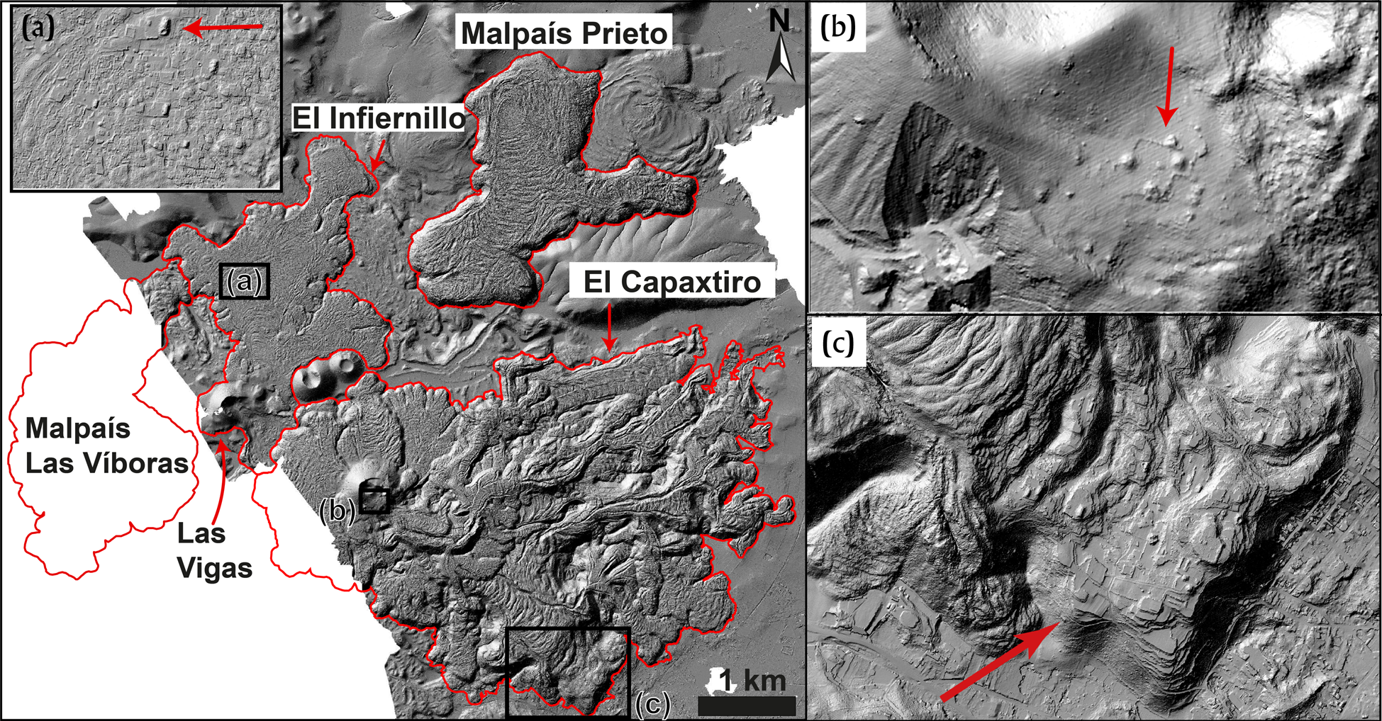
LiDAR image of the Malpaís de Zacapu lava flows. Red outline displays the area covered by each volcano. (a) Pre-Hispanic anthropogenic modification of El Infiernillo lava surface; (b) Capaxtiro crater archaeological site at the base of Capaxtiro vent; (c) El Palacio archaeological site on the lava surface of Capaxtiro's distal lava flow. Modified after Reyes-Guzmán et al. Reference Reyes-Guzmán, Siebe, Chevrel and Pereira2021.
The first eruption occurred during 1490–1380 b.c. (i.e., 3,200 ± 30 yr B.P.; Reyes-Guzmán et al. Reference Reyes-Guzmán, Siebe, Chevrel, Guilbaud, Salinas and Layer2018) and formed Las Vigas scoria cone and the associated Infiernillo lava flow field. This eruption started in a Strombolian fashion (explosive emission of a gas-rich, ash- and scoria-laden eruptive column), which led to the rapid formation of the Las Vigas scoria cone. Upon arrival to the surface of more degassed magma, the activity turned effusive and formed two lava flows, together called Infiernillo (“little hell” in Spanish). Jointly, both flows occupy an area of ~5.1 km2, with ~0.3 km3 of basaltic andesite (Figure 6a; Reyes-Guzmán et al. Reference Reyes-Guzmán, Siebe, Chevrel and Pereira2021).
Hill-shaded digital elevation model (DEM), showing main morphological features and the emplacement sequence of the lava flow fields from: (a) Infiernillo; (b) Malpaís Las Víboras; (c) Capaxtiro; and (d) Malpaís Prieto. Modified after Reyes-Guzmán et al. Reference Reyes-Guzmán, Siebe, Chevrel and Pereira2021; see original figures for details.
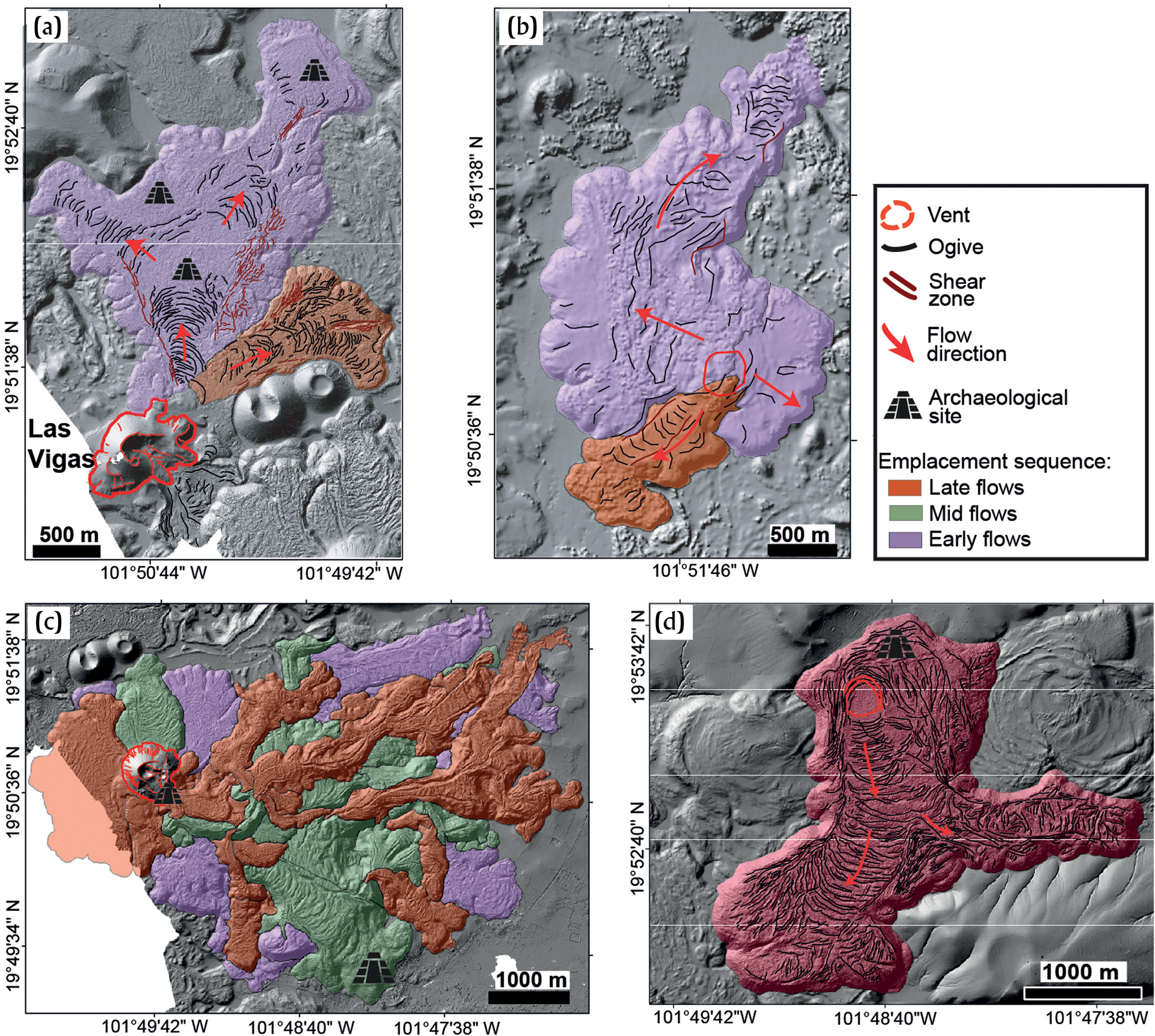
The second eruption was dated at 1340–940 b.c. (Mahgoub et al. Reference Mahgoub, Reyes-Guzmán, Böhnel, Siebe, Pereira and Dorison2018) and formed the ~100 m thick Malpaís Las Víboras block-type lava flow field that covers an area of ~5.9 km2, with ~0.5 km3 of andesites (Reyes-Guzmán et al. Reference Reyes-Guzmán, Siebe, Chevrel and Pereira2021). Although it lacks a prominent vent structure, its source can be distinguished from surface morphological features, and the flow field can be divided into two distinct units (Figure 6b; Reyes-Guzmán et al. Reference Reyes-Guzmán, Siebe, Chevrel and Pereira2021). This eruption was entirely effusive, since related explosive products, such as ash and scoria fallout layers were not found. Eruptive dynamics established from rock analyses, morphological features, and physical models suggest that the magma degassed sufficiently before reaching the surface (preventing explosive eruption), owing to a slow ascent through a porous substrate (Reyes-Guzmán et al. Reference Reyes-Guzmán, Siebe, Chevrel and Pereira2021).
The third eruption formed the Capaxtiro volcano. This structure was dated at 200–80 b.c. (Mahgoub et al. Reference Mahgoub, Reyes-Guzmán, Böhnel, Siebe, Pereira and Dorison2018) and erupted ~28 partly overlapping lava flow units (~150 m thick), which together cover an area of ~21 km2 (Figure 6c). A topographic high, displaying a morphology intermediate between that of a spatter cone and a dome, suggests that the eruption might have had a brief initial explosive phase, although ash-fallout deposits are entirely absent around Capaxtiro (Reyes-Guzmán et al. Reference Reyes-Guzmán, Siebe, Chevrel and Pereira2021). In contrast to the two previous eruptions, Capaxtiro emitted a much larger lava volume, estimated at ~3 km3, and its lava flows flowed mostly toward the lacustrine basin, which promoted the formation of an intricate pattern of numerous intertwined lava flow units (Reyes-Guzmán et al. Reference Reyes-Guzmán, Siebe, Chevrel, Guilbaud, Salinas and Layer2018, Reference Reyes-Guzmán, Siebe, Chevrel and Pereira2021).
The fourth eruption, and the most recent in the area, was dated at ~a.d. 900 (Mahgoub et al. Reference Mahgoub, Reyes-Guzmán, Böhnel, Siebe, Pereira and Dorison2018) and formed the Malpaís Prieto (Figure 6d). This effusive eruption emitted one single lava flow of 0.5 km3 that covers 5.7 km2 (Reyes-Guzmán et al. Reference Reyes-Guzmán, Siebe, Chevrel, Guilbaud, Salinas and Layer2018, Reference Reyes-Guzmán, Siebe, Chevrel and Pereira2021) This eruption, like Malpaís Las Víboras, was purely effusive, since associated pyroclastic deposits were not found (Reyes-Guzmán et al. Reference Reyes-Guzmán, Siebe, Chevrel and Pereira2021). According to Reyes-Guzmán et al. (Reference Reyes-Guzmán, Siebe, Chevrel and Pereira2021), this thick lava flow was emitted from a source point near its north margin and flowed to the south, where it became divided into two distinct lobes: one continued flowing to the south and the other flowed to the east, after becoming diverted by the Mesa El Pinal topographic high.
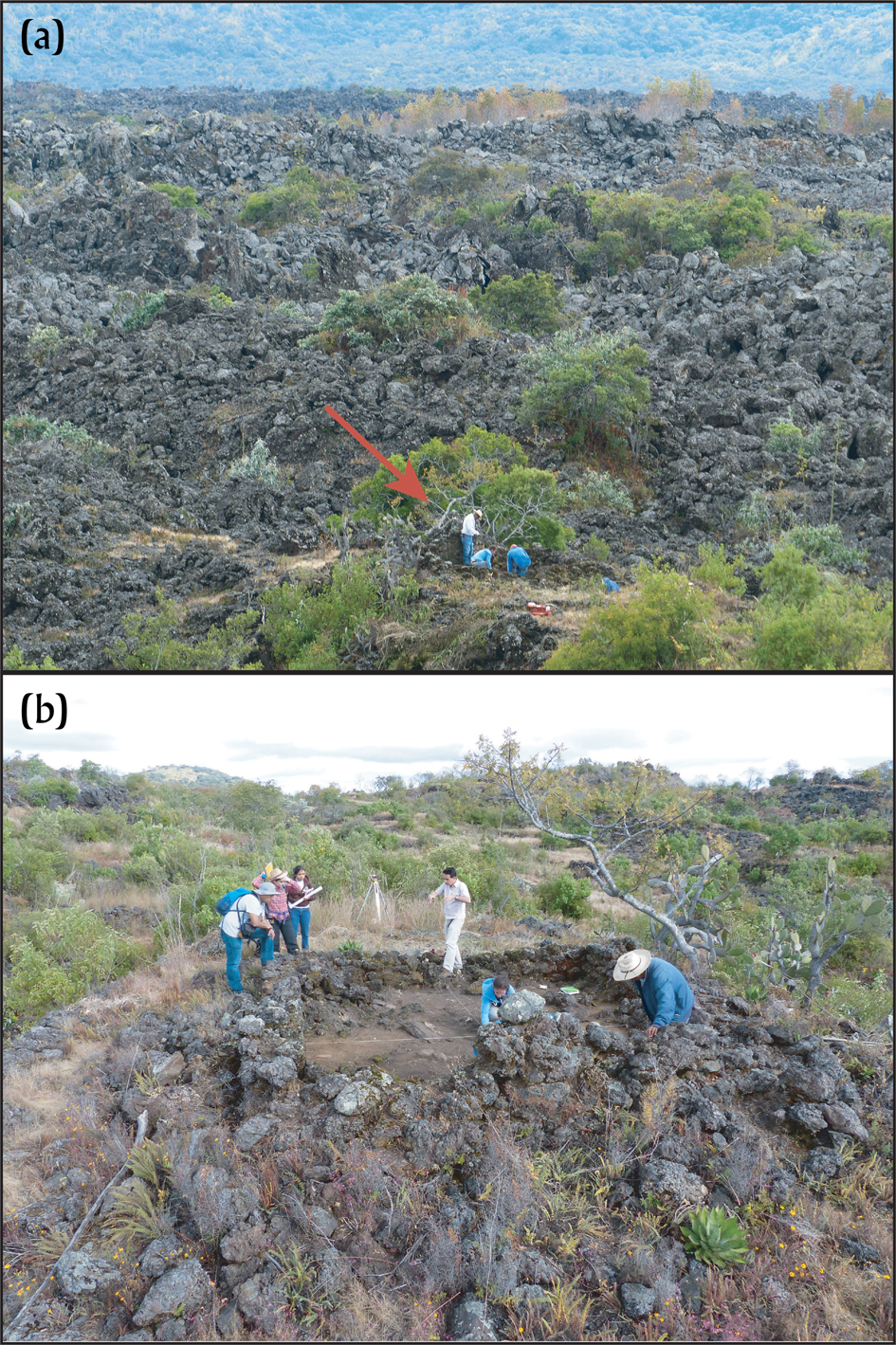
The oldest formations (Infiernillo and Malpaís Las Víboras) are covered by an incipient thin soil that is sufficient to sustain a mixed pine and oak forest. In stark contrast, the Malpaís Prieto (prieto means “dark” in Spanish) is almost devoid of any vegetation and exhibits a barren, moon-like landscape appearance (Figure 7a). However, the original lava surfaces of the Infiernillo (Figure 5a), and of some areas of Capaxtiro (Figures 5b and 5c) and Malpaís Prieto (Figure 7a and 7b), were rearranged into terraces and modified by pre-Hispanic dwellers during the Postclassic, forming today the archaeological sites of El Infiernillo, Palacio, and Malpaís Prieto, respectively (Figures 5 and 7).
(a) Archaeological excavation on Malpaís Prieto lava flow surface (red arrow); (b) archaeological excavation of an ancient house on Malpaís Prieto lava flow surface. Photographs by Siebe.
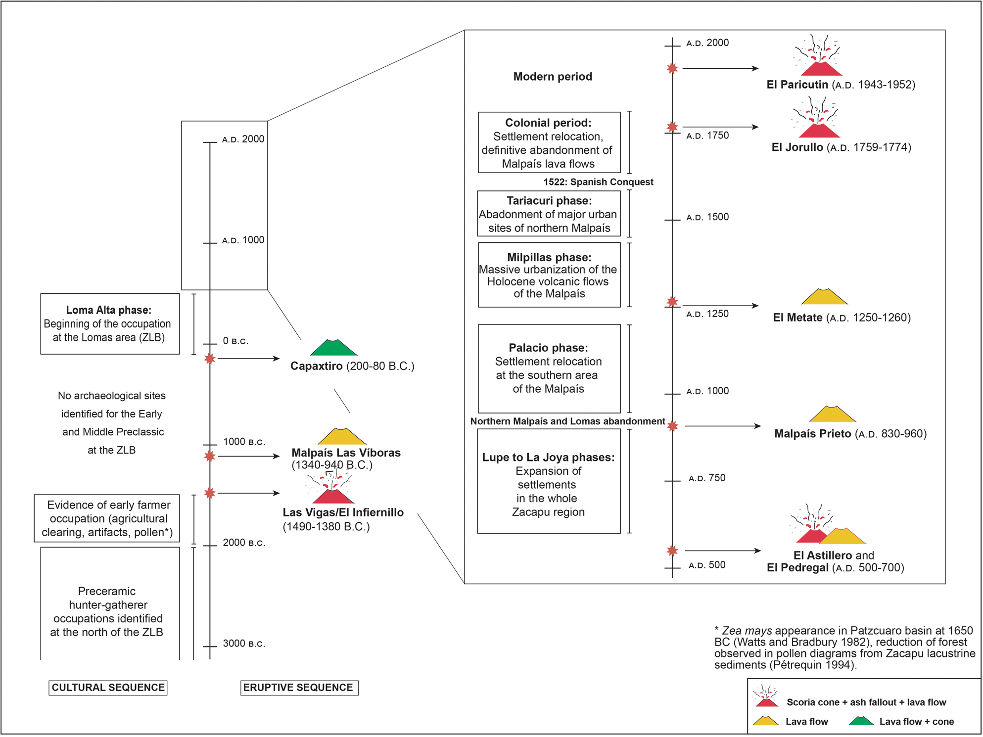
The very young age of these eruptions implies that they were contemporaneous with human settlement in the region (Figure 8), which started at least ~4000 b.c. (Pétrequin Reference Pétrequin1994). Although the eruptions were not documented by witnesses, we can assume (from descriptions of historical monogenetic eruptions such as Jorullo and Paricutin) that these eruptions were probably also preceded by months of significant earthquake activity and subterranean noises. These premonitory phenomena must have caused fear among the people inhabiting surrounding areas and warned them well before the impending eruptive activity. When the ascending magma finally reached the surface along faults, cracks opened in the ground and initial ash and scoria fallout from the eruptive column covered nearby areas (in the case of Las Vigas; Reyes-Guzmán et al. Reference Reyes-Guzmán, Siebe, Chevrel and Pereira2021), followed by lava flows that slowly flooded ravines and adjacent lowlands, significantly modifying the landscape (Figure 9). In the case of Malpaís Las Víboras, Capaxtiro, and Malpaís Prieto, ash-fallout did not occur, but lava emanated from fissures in the ground, emplacing thick viscous flows that advanced at velocities ranging between ~3 m/day (Malpaís Las Víboras) and ~47 m/day (El Infiernillo), depending largely upon their composition, temperature, and viscosity (for detailed calculations, see Reyes-Guzmán et al. Reference Reyes-Guzmán, Siebe, Chevrel and Pereira2021). The lava flows from El Infiernillo were not only the fastest, but also the hottest, with eruptive temperatures of ~1090°C. For Malpaís Las Víboras and Malpaís Prieto, eruptive temperatures ranged between 950°C and <1080°C, and for Capaxtiro between 1000°C and 1080°C (Reyes-Guzmán et al. Reference Reyes-Guzmán, Siebe, Chevrel and Pereira2021). Although this type of eruption can hardly be termed catastrophic, they nevertheless strongly impacted the lifestyle and activities of nearby dwellers. Magma ascent to the surface is usually closely associated with recurrent seismic activity that can last from weeks to months, and the subsequent eruption can take up to several years, causing forest fires and burying dwellings and farmlands (e.g., Paricutin and Jorullo eruptions). At the end of such eruptions, the landscape will have changed significantly, with noticeable alterations to the ecosystem, frequently causing migrations of wildlife and people (Chevrel et al. Reference Chevrel, Siebe, Guilbaud and Salinas2016a; Gadow Reference Gadow1930; Nolan Reference Nolan, Sheets and Grayson1979; Wilcox Reference Wilcox1954). In the case of the eruptions that formed the Malpaís de Zacapu, the Infiernillo lava flows may have taken around seven months, while Malpaís Las Víboras and Malpaís Prieto may have formed in about three years, and Capaxtiro probably up to around 30 years to be emplaced (Reyes-Guzmán et al. Reference Reyes-Guzmán, Siebe, Chevrel and Pereira2021). This means that during the last ~3,200 years, the western margin of the ZLB was recurrently subjected to short periods of volcanic activity with recurrence intervals of ~400 years between the Infiernillo and Malpaís Las Víboras eruptions, ~800 years between the Malpaís Las Víboras and Capaxtiro eruptions, and ~1000 years between the Capaxtiro and Malpaís Prieto eruptions. During the past ~1100 years, volcanic activity has not taken place in this area; however, from the above it should not be surprising if another monogenetic eruption were to occur in the future.
Timeline (in calendar years) of eruptions in the western ZLB; other eruptions in the MGVF are shown for comparison. Main archaeological phases for the Zacapu basin are also indicated (quadrangles at the left). Dates for the Malpaís de Zacapu are from Reyes-Guzmán et al. (Reference Reyes-Guzmán, Siebe, Chevrel, Guilbaud, Salinas and Layer2018) and Mahgoub et al. (Reference Mahgoub, Reyes-Guzmán, Böhnel, Siebe, Pereira and Dorison2018); for El Astillero and El Pedregal from Larrea et al. (Reference Larrea, Siebe, Juárez-Arriaga, Salinas, Ibarra and Böhnel2019b); and for El Metate from Chevrel et al. (Reference Chevrel, Siebe, Guilbaud and Salinas2016a).
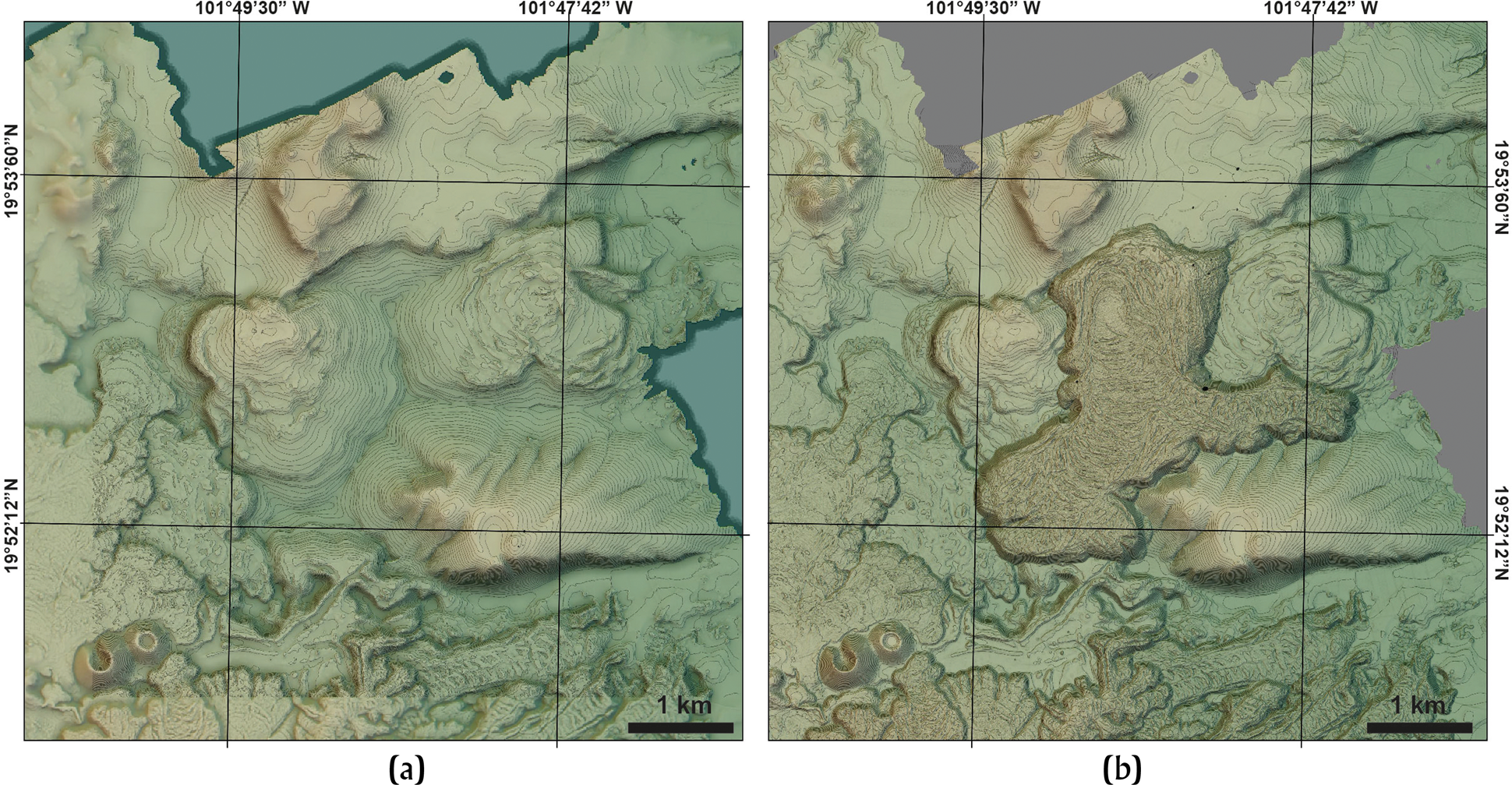
Topographic reconstruction of the terrain before (a), and after (b) the a.d. ~900 Malpaís Prieto lava flow eruption. Modified after Dorison Reference Dorison2019.
Discussion
Volcanic impact on human occupation of the western Zacapu basin
As described above, the Malpaís de Zacapu eruptions in the western ZLB occurred in an almost purely effusive fashion (Reyes-Guzmán et al. Reference Reyes-Guzmán, Siebe, Chevrel and Pereira2021) between ~1450 b.c. (~3,200 yr B.P.; Reyes-Guzmán et al. Reference Reyes-Guzmán, Siebe, Chevrel, Guilbaud, Salinas and Layer2018) and a.d. 900 (Mahgoub et al. Reference Mahgoub, Reyes-Guzmán, Böhnel, Siebe, Pereira and Dorison2018). These relatively young ages imply that they were almost certainly witnessed by human populations (Figure 8). According to Faugère (Reference Faugère2006), the first human occupation archaeologically recorded near the Zacapu basin dates back to 5000–2000 b.c., near the Lerma river valley to the north. Around 2000 b.c., shortly before the Las Vigas (Infiernillo) eruption, the Zacapu basin also became sparsely populated (Figure 8). Sediment cores extracted at the lake swamps and pollen analyses have recorded anthropogenic artifacts, as well as indications of forest reduction related to agricultural activities (Pétrequin Reference Pétrequin1994). Although the archaeological record becomes better documented since 100 b.c., it is possible that earlier occupations were present in the region, but have not yet been found because of subsequent covering by sediments (e.g., Arnauld and Faugère-Kalfon Reference Arnauld and Faugère-Kalfon1998; Arnauld et al. Reference Arnauld, Carot and Fauvet-Berthelot1993; Michelet Reference Michelet1993; Michelet et al. Reference Michelet, Arnauld and Fauvet-Berthelot1989) and products from the volcanic activity (Reyes-Guzmán et al. Reference Reyes-Guzmán, Siebe, Chevrel and Pereira2021). Furthermore, it could be possible that the volcanic activity during Early and Late Preclassic periods discouraged ancient farmers from establishing villages in the western ZLB. Although the Las Vigas eruption was short-lived, its impact on the environment was amplified by the ash-fall that altered the surroundings lands, in addition to the changes produced by the formation of the Infiernillo lava flow. Such a scenario was observed in the case of Paricutin volcano, where the accumulation of ash and lava impacted local flora and fauna, limiting drastically the agricultural possibilities (Rees Reference Rees, Sheets and Grayson1979). Additionally, the subsequent eruptions of Malpaís Las Víboras and Capaxtiro impacted again the region by covering large areas (~25 km2) with lavas that modified the landscape of the western shore of the Zacapu marsh. Pétrequin (Reference Pétrequin1994) has also suggested a direct relationship between the Capaxtiro eruption and the formation of the Las Lomas area (located at the shore of the Zacapu lake; Figures 3 and 4). If this hypothesis is correct, the formation of Las Lomas would be more recent than previously assumed, and therefore would shortly precede the beginning of an important human occupation developed in the ZLB since 100 b.c. (Arnauld and Faugère-Kalfon Reference Arnauld and Faugère-Kalfon1998; Arnauld et al. Reference Arnauld, Carot and Fauvet-Berthelot1993; Michelet Reference Michelet1993; Michelet et al. Reference Michelet, Arnauld and Fauvet-Berthelot1989), but more research is required to validate this.
According to Carot et al. (Reference Carot, Fauvet-Berthelot, Barba, Link, Ortíz, Hesse, Ricardo Ávila, Emphoux, Gastélum, Ramírez, Schöndube and Valdez1998), a ceremonial center found in the lacustrine swamps (Las Lomas area) corresponds to the Loma Alta phase (100 b.c.–a.d. 550), and shows some evidence for a cult related to fire and volcanoes, as suggested by the orientation of some ceremonial buildings, and the presence of an early image of the fire god (Carot and Ponce López Reference Carot and López1997). This could indicate that the inhabitants of the Loma Alta phase witnessed the eruption of Capaxtiro and attributed a ceremonial center to it. Also, at the base of the Capaxtiro cone (Figure 5b), a ceremonial site correlating with the Lupe phase (a.d. 600–850) consists of a plaza surrounded by four pyramid mounds, with a possible central altar indicating a sacred character, as at Loma Alta (Michelet et al. Reference Michelet, Migeon and Pereira1995).
During the Lupe phase, the southern lacustrine basin was still inhabited by local people, but the occupation expanded to the entire region. An important cluster of monumental and residential sites developed at the northwest edge of the western ZLB (on the surface of Las Flores, Las Minas, Las Florecitas-El Malpaisillo, and Mesa del Bolsón volcanos; see Figure 4; Dorison Reference Dorison2019; Pereira et al. Reference Pereira, Dorison, Ramirez, Gillot and Michelet2023). This area shows an important economic development based on the intensive exploitation of the volcanic environment for agriculture (Dorison Reference Dorison2019; Dorison and Siebe Reference Dorison and Siebe2023), and mineral resources (Quezada and Darras Reference Quezada Ramirez and Darras2023). The abrupt abandonment of this area by the end of La Joya phase (a.d. 850–900) coincides interestingly with the Malpaís Prieto eruption. Although this was a purely effusive eruption, it directly impacted seven sites with late Epiclassic occupation (Arnauld and Faugère-Kalfon Reference Arnauld and Faugère-Kalfon1998; Pereira Reference Pereira, Forest, Jadot, Darras, Arnauld, Beekman and Pereira2021), and was certainly terrifying enough to cause the abandonment of sites located at the northern edge of the Malpaís area.
The Palacio phase (a.d. 900–1200) was marked by a drastic population reduction of the northern edge of the Malpaís de Zacapu, as well as of the Las Lomas area (Arnauld et al. Reference Arnauld, Carot and Fauvet-Berthelot1993), probably related to the Malpaís Prieto eruption (Figure 8). The occupation moved to the north (Lerma valley) and to the southwest of the ZLB. Settlements at the shores of the lake decreased, while a large portion of the population concentrated at the Palacio site, located on the distal margin of El Capaxtiro's widest lava flow unit (Figure 5c).
The Milpillas phase (a.d. 1200–1450) was characterized by a dense population (~20,000 inhabitants; see Forest Reference Forest2023) living in urban areas erected on the surfaces of the Infiernillo, Capaxtiro, and Malpaís Prieto lava flows. After two to six generations (a.d. ~1400/1430), this large population probably migrated to the Patzcuaro lake basin in a sudden and organized fashion for reasons that remain poorly understood.
The better-known part of the archaeological record in the Zacapu lacustrine basin starts almost immediately after the eruption of Capaxtiro (200–80 b.c.) and continues until an abandonment of the basin area occurred at the end of the Lupe phase, when Malpaís Prieto erupted (~a.d. 900). Additionally, the reoccupation of the region (~300 years later) roughly coincides with the timing of two contemporary events. The first event is the eruption of the El Metate shield volcano at ~a.d. 1250 (Figures 2 and 8), which could have caused the migration of people towards other areas of the MGVF, including the ZLB (Chevrel et al. Reference Chevrel, Siebe, Guilbaud and Salinas2016a, Reference Chevrel, Guilbaud and Siebe2016b), and the second is a period of abandonment of the southern Lerma basin. It has been proposed that a large part of the population that occupied the Malpaís de Zacapu came from that area (Arnauld and Faugère-Kalfon Reference Arnauld and Faugère-Kalfon1998). Furthermore, the Relación de Michoacán (Alcalá Reference Alcalá2000 [1541]), an ethnohistoric document compiled in the sixteenth century by the Franciscan friar Jerónimo de Alcalá, mentions that new people, the Uacusecha, who spoke a similar language but had different behavior and customs from those already dwelling in the ZLB, settled on the Malpaís. They were guided by their main deity, Curicaveri (god of fire), to the Malpaís, where they rose by taking advantage of their rock-building and hunting skills. Recent studies revealed that they were well-adapted to dwell on the rocky substrate of the lava surfaces devoid of soil and vegetation (Forest Reference Forest2014; Forest et al. Reference Forest, Costa, Combey, Dorison and Pereira2019; Pereira et al. Reference Pereira, Forest, Jadot, Darras, Arnauld, Beekman and Pereira2021) and became proficient in lithic tool-manufacturing techniques (Darras et al. Reference Darras, Mireles, Siebe, Quezada, Castañeda and Reyes-Guzmán2017). They built urban conglomerates, with walled edifices and terraces, by modifying the original morphological features (e.g., pressure ridges, levées; see Figure 5) of the lava flows and by optimizing the hard, rocky substrate to their needs by covering it with softer clayey soil aggregates (Forest Reference Forest2014; Reyes-Guzmán et al. Reference Reyes-Guzmán, Siebe, Chevrel, Guilbaud, Salinas and Layer2018). This means that recent volcanic activity in the western Zacapu basin provided natural benefits, including on-site construction materials and a topographically elevated position, with a view over the basin from which approaching enemies could be easily spotted. Its position between the forests in the hinterland and the lake's shore allowed them to exploit resources from both biomes, including timber, fish, and aquatic fowl (see Dorison Reference Dorison2019; Manin et al. Reference Manin, Lefèvre and Pereira2015). Previous geological studies (Mahgoub et al. Reference Mahgoub, Reyes-Guzmán, Böhnel, Siebe, Pereira and Dorison2018; Reyes-Guzmán et al. Reference Reyes-Guzmán, Siebe, Chevrel, Guilbaud, Salinas and Layer2018, Reference Reyes-Guzmán, Siebe, Chevrel and Pereira2021) provided information with regard to the ages, morphologies, dynamics, and durations of the Malpaís de Zacapu eruptions, allowing us to better constrain the impact of these eruptions on pre-Hispanic human settlements around the ZLB. Although these eruptions were mostly effusive (Reyes-Guzmán et al. Reference Reyes-Guzmán, Siebe, Chevrel and Pereira2021), the rumbling noises and seismic tremors that preceded them would have inspired sufficient fear to disrupt daily activities. Furthermore, the relatively long duration of lava flow emplacement (up to several years) probably forced the displacement of people away from the immediate surroundings of the eruption sites. However, the relatively gentle effusive style may also have inspired enough confidence to return to the areas affected by the eruptions, once these had ceased and the flows had cooled, and even to eventually recolonize the zones now occupied by newly formed lava flows.
The impact of monogenetic eruptions on pre-Hispanic populations and human adaptation
It is known that the MGVF has been active for the last 5 Ma (Guilbaud et al. Reference Guilbaud, Siebe, Layer, Salinas, Castro-Govea, Garduño-Monroy and Le Corvec2011, Reference Guilbaud, Siebe, Layer and Salinas2012; Hasenaka and Carmichael Reference Hasenaka and Carmichael1985a, Reference Hasenaka and Carmichael1985b), but only became occupied by humans in the Late Pleistocene (Pétrequin Reference Pétrequin1994). The timing of the initial colonization of Mexico remains a highly debated topic (Ardelean et al. Reference Ardelean, Becerra-Valdivia, Pedersen, Schwenninger, Oviatt, Macías-Quintero, Arroyo-Cabrales, Sikora, Ocampo-Díaz, Rubio-Cisneros, Watling, de Medeiros, De Oliveira, Barba-Pingarón, Ortiz-Butrón, Blancas-Vázquez, Rivera-González, Solís-Rosales, Rodríguez-Ceja, Gandy, Navarro-Gutierrez, De La Rosa-Díaz, Huerta-Arellano, Marroquín-Fernández, Martin Martínez-Riojas, López-Jiménez, Higham and Willerslev2020), but might have occurred during the Last Glacial Maximum (26,500–19,000 years ago). The oldest human remains found so far in north-central Michoacan date back to 5200 b.c. at Cueva de los Portales (Faugère Reference Faugère2006), and, more recently, remains dated at ~12,000 b.c. were reported from Cueva de los Hacheros (Punzo-Díaz and Martínez-Vázquez Reference Punzo-Díaz and Martínez-Vázquez2018, Reference Punzo-Díaz, Martínez-Vázquez, Lohse, Borejsza and Joyce2021) at the southern limit of the MGVF (Figure 2). Recent radiometric dating efforts in the MGVF (e.g., Chevrel et al. Reference Chevrel, Siebe, Guilbaud and Salinas2016a; Guilbaud et al. Reference Guilbaud, Siebe, Layer and Salinas2012, Reference Guilbaud, Hernández-Jiménez, Siebe and Salinas2021; Kshirsagar et al. Reference Kshirsagar, Siebe, Guilbaud and Salinas2015, Reference Kshirsagar, Siebe, Guilbaud and Salinas2016; Mahgoub et al. Reference Mahgoub, Böhnel, Siebe, Salinas and Guilbaud2017; Osorio-Ocampo et al. Reference Osorio-Ocampo, Macías, Pola, Cardona-Melchor, Sosa-Ceballos, Garduño-Monroy, Layer and García-Sánchez2018; Pola et al. Reference Pola, Macías, Garduño-Monroy, Osorio-Ocampo and Cardona-Melchor2014; Ramírez-Uribe et al. Reference Ramírez-Uribe, Siebe, Salinas, Guilbaud, Layer and Benowitz2019; Reyes Guzmán et al. Reference Reyes-Guzmán, Siebe, Chevrel, Guilbaud, Salinas and Layer2018) have revealed numerous Late Pleistocene/Holocene monogenetic eruptions, and it seems safe to say that the average time interval between them is <400 years. Many of these must have affected ancient population groups since the first arrival of early man in this part of the American continent, although evidence for the direct impact of eruptions on early pre-Hispanic dwellers remains sparse. Besides the case of the a.d. 900 Malpaís Prieto eruption that triggered a temporary abandonment of the Malpaís de Zacapu area, the only other known case is that of the El Astillero and El Pedregal monogenetic volcanoes (Figure 8) south of Tancítaro, whose eruption was dated at a.d. 500–700 (Larrea et al. Reference Larrea, Siebe, Juárez-Arriaga, Salinas, Ibarra and Böhnel2019b), and where abundant pottery sherds and obsidian artifacts were discovered directly underlying the ash-fallout deposits. Unfortunately, this area has so far not been investigated by archaeologists, but this eruption probably caused the mobilization of people toward surrounding areas within the MGVF.
On the other hand, evidence for the cultural adaptation of humans to dwell on newly created volcanic landscapes, in particular on apparently inhospitable young lava flows, is far more abundant (Table 1), although still enigmatic. One case is the previously described Malpaís de Zacapu, where the Uacusecha used the rocks from the lava flows to build their cities after smoothing parts of their rough surfaces. A less studied case in the ZLB is the Late Postclassic (a.d. 1200–1521) archaeological site of Cortijo Viejo (Migeon Reference Migeon2016), located at the southern margin of the ZLB (Figure 2) on the most distal lava flow from the Mazcuta scoria cone (Ramírez-Uribe et al. Reference Ramírez-Uribe, Siebe, Salinas, Guilbaud, Layer and Benowitz2019). Another well-documented example from the MGVF is the archaeological site of Angamuco (Figure 2), located on the young lava surface of the Rancho Seco scoria cone (Ramírez et al. Reference Ramírez-Uribe, Siebe, Salinas, Guilbaud, Layer and Benowitz2019, Reference Ramírez-Uribe, Siebe, Chevrel and Fisher2021) in the eastern part of the Patzcuaro basin. Angamuco was inhabited during the Postclassic period (a.d. 900–1521) by a large population that modified the lava flow surface to build residences, ceremonial buildings and pyramids (similar to those observed at Tzintzuntzan, the capital of the Tarascan empire), agricultural terraces, ball-courts, channels, and a vast network of roads (Fisher et al. Reference Fisher, Cohen, Fernández-Diaz and Leisz2017). An additional case from the Patzcuaro basin area is the site of Urichu at the western shore of the lake on the lava flow surface from the Holocene La Taza scoria cone (Pollard and Cahue Reference Pollard and Cahue1999). The Itziparátzico site (Maldonado Reference Maldonado2005), near a former pond close to the present town of Santa Clara del Cobre, is also on a young lava flow from Cerro Colorado volcano and was a metallurgical center at the time of the Tarascan Empire (Maldonado Reference Maldonado2005). Although not all of these sites erected on young lava flows are well-studied, it seems that their common denominator is their location near a lake and its aquatic resources (Figure 2). This strategic position, together with the abundance of readily available construction materials, seemed attractive for establishing population centers of urban proportions.
Compilation of known Late Pleistocene to Holocene volcanoes with archaeological sites in the Michoacan-Guanajuato volcanic field
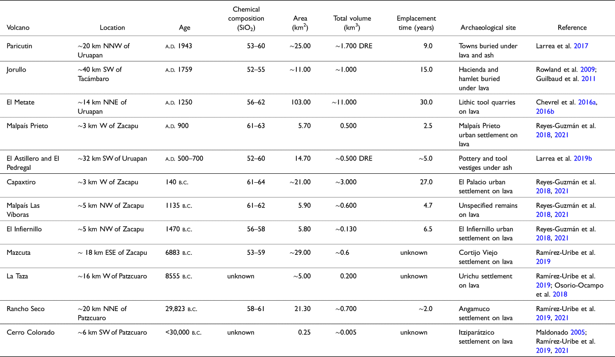
Note: The total volume includes tephra and lava, considering the vol. % of vesicles, except for those marked DRE (dense rock equivalent).
In this context it is important to notice that these cases are not restricted to the MGVF, but have also been reported from other regions in the TMVB (Figure 1). The most notable examples are Cantona and Teotenango. Cantona is a large archaeological site (~12 km2), located on the Holocene lava surface of the Tepeyahualco basaltic lava flow, associated with Los Humeros caldera in the present state of Puebla (Figure 1). Similar to the examples from the MGVF, it is near the shore of a lake in the intermontane Serdán-Oriental basin (Castillo Bernal Reference Castillo Bernal2013) and was inhabited from the Late Preclassic (200 b.c.) to the Late Classic (a.d. 900) periods (García-Cook and Merino Reference García-Cook and Merino1998). Within the Serdán-Oriental basin, an additional site that remains to be explored, Cuauhyehualulco, is located on the lava flows of the Holocene El Brujo shield (Figure 1; García-Cook and Zamora-Rivera Reference García-Cook and Zamora-Rivera2010). Finally, the archaeological site of Teotenango is located to the east of Nevado de Toluca stratovolcano on the Holocene monogenetic Cerro Tetépetl lava flow (Bloomfield Reference Bloomfield1973) in the Upper Lerma lacustrine basin (Figure 1). It was built by the Matlazinca people (Piña Chan Reference Piña Chan1972) and occupied from the Late Classic (a.d. 650) to the Late Postclassic (a.d. 1574).
From the above, it becomes clear that volcanic activity has been an integral part of the natural environment since its occupation by early man in central Mexico. Although eruptions certainly disrupted periodically the lifestyles and activities of the ancient inhabitants, this environment also provided benefits (e.g., fertile soils, lithic resources), which, in conjunction with a lacustrine habitat, made it sufficiently attractive for permanent occupation. It is obvious that diverse Mesoamerican people were able to adapt to these circumstances and even dwell in urban-sized settlements on the apparently inhospitable rugged young lava flows. When, where, and why did this occur for the first time? How did this practice spread along central Mexico? At the time of the Spanish conquest, these once densely inhabited terrains (malpaíses) were largely abandoned—a social phenomenon that still begs a thorough and comprehensive explanation. Answers to these questions are not only of archaeological interest, but might also provide valuable practical lessons for present and future generations living along the still active TMVB.
Conclusions
The Malpaís de Zacapu is a Late Holocene monogenetic cluster formed by four separate eruptions, beginning ~1450 b.c., with repose periods ranging between ~400 and ~1000 years (Mahgoub et al. Reference Mahgoub, Reyes-Guzmán, Böhnel, Siebe, Pereira and Dorison2018; Reyes-Guzmán et al. Reference Reyes-Guzmán, Siebe, Chevrel, Guilbaud, Salinas and Layer2018, Reference Reyes-Guzmán, Siebe, Chevrel and Pereira2021). Furthermore, the recent volcanological study carried out by Reyes-Guzmán and colleagues (2021), revealed that these monogenetic eruptions ranged from Strombolian (mildly explosive) to purely effusive in style. Seismic and acoustic premonitory phenomena, high initial temperatures (~1000°C) of lava flows, and their relatively long emplacement durations, ranging from months to years (~7 months for El Infiernillo, ~3 years for Malpaís Las Víboras and Malpaís Prieto, and a little less than 30 years for Capaxtiro) made the area unsafe and ultimately changed the local environment, impacting on the daily life of surrounding human populations. The MGVF has been volcanically active since 5 Ma (Guilbaud et al. Reference Guilbaud, Siebe, Layer, Salinas, Castro-Govea, Garduño-Monroy and Le Corvec2011, Reference Guilbaud, Siebe, Layer and Salinas2012; Hasenaka and Carmichael Reference Hasenaka and Carmichael1985a, Reference Hasenaka and Carmichael1985b), but has only been permanently inhabited by humans in recent geologic time (since at least 5,000 years ago, but maybe already since the Last Glacial Maximum; Pétrequin Reference Pétrequin1994). This implies that humans had to coexist with volcanoes since their first arrival in the MGVF, a fact that required a process of continuous cultural adaptation. The latter underscores the importance of interdisciplinary studies (geological, archaeological, etc.) when trying to better understand resilience strategies developed by ancient people. Such knowledge might be of help in being prepared for future eruptions in this region.
Acknowledgments
LIDAR data were collected in 2015 by the National Center for Airborn Laser Mapping (NCALM, University of Houston) employing a Teledyne Optech Titan MW multispectral lidar mounted on a Piper Chieftain (PA-31-350) aircraft covering an area of 91.3 km². The operation was coordinated by J.C. Fernández-Díaz (NCALM, University of Houston). We kindly thank archaeologists O. Quezada and V. Darras for advice in regard to archaeological questions. We thank A. Dorison for producing amazing images that helped reconstruct the topography before the Malpaís Prieto eruption.
Funding
This work was financed by projects DGAPA-PAPIIT IN103618 and IN104221 granted to C. Siebe. N. Reyes-Guzmán was financed by a CONACYT graduate fellowship (2017-2019), while O.M. Chevrel was financed by a DGAPA-UNAM postdoctoral fellowship. G. Pereira's archaeological investigations were financed by the Uacusecha archaeological Project (Ministère de l'Europe et des Affaires Etrangères of France and CNRS) and the ANR Mesomobile project.


 Open access