

1. Introduction
The Greater Caucasus is Europe's largest mountain belt and yet, in marked contrast to the Alps, Pyrenees and Carpathians, relatively little is known about its evolution. Many modern analytical techniques, such as thermochronology, have barely been attempted within the range despite having been applied with success elsewhere (e.g. Cederbom et al. Reference Cederbom, Sinclair, Schlunegger and Rahn2004; Gunnell et al. Reference Gunnell, Calvet, Brichau, Carter, Aguilar and Zeyen2009). This paper presents the results of a thermochronometric study from the western part of the Greater Caucasus. It provides initial insights into the exhumation of the range that, it is hoped, will be built upon by others in this highly complex and politically troubled region.
2. Regional background
The western Greater Caucasus is situated at the southern deformed edge of the Scythian Platform (part of Eurasia), north of the eastern Black Sea basin and a series of accreted arcs, oceanic slivers, continental fragments and sedimentary basins of the Tethyside orogenic collage (Şengör & Yılmaz, Reference Şengör and Yilmaz1981; Dixon & Robertson, Reference Dixon and Robertson1984; Şengör, Reference Şengör1987; Şengör & Natal'in, Reference Şengör, Natal'in, An and Harrison1996; Fig. 1). It comprises a central core of Gondwana-derived, predominantly Lower to middle Palaeozoic crystalline protolith and middle Palaeozoic island arc and ophiolitic material that were metamorphosed and intruded during their Variscan accretion to the southern margin of Laurasia (Zonenshain, Kuzmin & Natapov, Reference Zonenshain, Kuzmin and Natapov1990; Hanel, Gurbanov & Lippolt, Reference Hanel, Gurbanov and Lippolt1992; Hanel et al. Reference Hanel, Lippolt, Kober, Gurbanov and Borsuk1993; Somin et al. Reference Somin, Kotov, Sal'nikova, Levchenkov, Pis'mennyi and Yakovleva2006; Somin, Lepekhina & Konilov, Reference Somin, Lepekhina and Konilov2007; Zakariadze et al. Reference Zakariadze, Dilek, Adamia, Oberhänsli, Karpenko, Bazylev and Solov'eva2007; Somin, Potapenko & Smul'skaya, Reference Somin, Potapenko and Smul'skaya2009; Treloar et al. Reference Treloar, Mayringer, Finger, Gerdes, Shengalia and Dalkılıç2009; Fig. 2). Mesozoic sediments onlap this crystalline core and record a series of extensional and compressional events that resulted from Tethyan active-margin processes further to the south. Middle to end-Triassic compressional/transpressional events (the early Cimmerian orogeny, sensu Nikishin et al. Reference Nikishin, Ziegler, Panov, Nazarevich, Brunet, Stephenson, Bolotov, Korotaev, Tikhomirov, Ziegler, Cavazza, Robertson and Crasquin-Soleau2001) were followed by Early Jurassic extension/transtension, which led to the formation of deep sedimentary troughs (the Greater Caucasus Basin) both to the north of the core of the western Greater Caucasus and to the south, between it and similar crystalline basement exposed in the Dziruli Massif (Nikishin et al. Reference Nikishin, Cloetingh, Brunet, Stephenson, Bolotov, Ershov, Crasquin-Soleau and Barrier1998b; Dercourt et al. Reference Dercourt, Gaetani, Vrielynck, Barrier, Biju-Duval, Brunet, Cadet, Crasquin and Sandulescu2000; Nikishin et al. Reference Nikishin, Ziegler, Panov, Nazarevich, Brunet, Stephenson, Bolotov, Korotaev, Tikhomirov, Ziegler, Cavazza, Robertson and Crasquin-Soleau2001; Golonka, Reference Golonka2004; Saintot et al. Reference Saintot, Brunet, Yakovlev, Sébrier, Stephenson, Ershov, Chalot-Prat, McCann, Gee and Stephenson2006a; Figs 2, 3). Middle Jurassic (middle Cimmerian) deformation led to the partial inversion of these basins before further extension/transtension occurred in Early Cretaceous time.
Schematic tectonic map showing the Greater Caucasus at the northern margin of the Arabia–Eurasia collision zone, the current GPS-constrained motion of the region relative to stable Eurasia and the occurrence of instrumentally recorded earthquakes M ≥ 4.5. Structures are extended from Allen et al. (Reference Allen, Vincent, Alsop, Ismail-Zadeh and Flecker2003), GPS motions are taken from Reilinger et al. (Reference Reilinger, McClusky, Vernant, Lawrence, Ergintav, Cakmak, Ozener, Kadirov, Guliev, Stepanyan, Nadariya, Hahubia, Mahmoud, Sakr, ArRajehi, Paradissis, Al-Aydrus, Prilepin, Guseva, Evren, Dmitrotsa, Filikov, Gomez, Al-Ghazzi and Karam2006) and the seismicity record from the US National Earthquake Information Center catalogue (1973–June 2009). The study area is highlighted in the box and selected Neotethyan suture zones shown by dashed lines. Abbreviations: AS – Apsheron sill; AT – Adjara–Trialet belt; BS – Bitlis suture; CCB – Central Caspian Basin; EBS – Eastern Black Sea; EGC – eastern Greater Caucasus; IAES – İsmir–Ankara–Erzincan suture; PT – Pontides; SCB – South Caspian Basin; T – Talysh; TA – Taurides–Anatolides; TC – Transcaucasus; WBS – Western Black Sea; WGC – western Greater Caucasus; ZS – Zagros suture. For a colour version of this figure see the online Appendix at http://journals.cambridge.org/geo.

Thermochronometric data summary map for the western Greater Caucasus. Bedrock samples record the thermal history of the sample site, while the Cenozoic sediment samples record the thermal history of their catchment areas within the evolving Caucasus mountain belt. The white transparent region represents the catchment area of the Inguri River upstream of cosmogenic sample site WG21/1 across which an erosion rate equivalent to ~ 1.1 km Ma−1 was derived. The fault plane solution for the Racha earthquake is from Triep et al. (Reference Triep, Abers, Lerner-Lam, Mishatkin, Zakharchenko and Starovoit1995). Note that the dataset of Král & Gurbanov (Reference Král and Gurbanov1996) is likely to be inaccurate due to the use of less reliable FT methodologies. The background map is a compilation of Soviet-era geological maps with standard colours: red – crystalline basement; brown-grey – Devonian–Carboniferous; pink-purple – Permo-Triassic; blue – Jurassic; green – Cretaceous; orange – Palaeogene; yellow – Neogene. The relationship between cooling age (basement samples) or cooling and depositional age lag time (sediments) and erosion rate was calculated using AGE2EDOT, assuming an average geothermal gradient of 40 °C km−1, and is an approximation. For location see Figure 1.

Cross-section through the western Greater Caucasus based on original field observations and the mapping of Melnikov, Srabony'an & Kokarev (Reference Melnikov, Srabony'an and Kokarev1994) and Lavrishchev, Prutskiy & Semenov (Reference Lavrishchev, Prutskiy and Semenov2002). For location see Figure 2. For a colour version of this figure see the online Appendix at http://journals.cambridge.org/geo.

South of the Greater Caucasus, Late Cretaceous to Early Cenozoic deformation occurred across a large part of the Tethyside orogenic collage. Most notably, the Late Paleocene to Middle Eocene terminal collision of the Pontide–Transcaucasus and Tauride–Anatolide regions (along the İzmir–Ankara–Erzincan suture zone; Fig. 1) resulted in the elimination of northern Neotethys (Şengör & Yılmaz, Reference Şengör and Yilmaz1981; Okay & Şahintürk, Reference Okay, Şahintürk and Robinson1997; Yılmaz et al. Reference Yilmaz, Tüysüz, Yiğitbaş, Can Genç, Şengör and Robinson1997; Okay & Tüysüz, Reference Okay, Tüysüz, Durand, Jolivet, Horváth and Séranne1999; Okay, Tansel & Tüysüz, Reference Okay, Tansel and Tüysüz2001; Boztuğ et al. Reference Boztuğ, Joncheere, Wagner and Yeğingil2004; Rice, Robertson & Ustaömer, Reference Rice, Robertson, Ustaömer, Robertson and Mountrakis2006; Robertson, Parlak & Ustaömer, Reference Robertson, Parlak, Ustaömer, Van Hinsbergen, Edwards and Govers2009). This event is marked by a regional unconformity identified both at outcrop and in Black Sea seismic data (Okay & Şahintürk, Reference Okay, Şahintürk and Robinson1997; Yılmaz et al. Reference Yilmaz, Tüysüz, Yiğitbaş, Can Genç, Şengör and Robinson1997; Afanasenkov, Nikishin & Obukhov, Reference Afanasenkov, Nikishin and Obukhov2007; Apaydın et al. Reference Apaydin, Menlikli, Sipahioğlu, Aydemir and Dalkılıç2009; Güney et al. Reference Güney, Demirer, Sipahioğlu, Aydemir and Dalkılıç2009; Khriachtchevskaia, Stovba & Stephenson, Reference Khriachtchevskaia, Stovba, Stephenson, Sosson, Kaymakci, Stephenson, Bergerat and Starostenko2010). Early to Middle Eocene post-collisional onlap was associated with widespread, predominantly Middle Eocene, post-collisional volcanism south of the Greater Caucasus (attributed to slab break-off: Genç & Yılmaz, Reference Genç and Yilmaz1997; Keskin, Genç & Tüysüz, Reference Keskin, Genç and Tüysüz2008; Dilek & Altunkaynak, Reference Dilek, Altunkaynak, Van Hinsbergen, Edwards and Govers2009). Volcanism was accompanied by transtensional basin formation in the Transcaucasus (the Talysh and Adjara–Trialet basins: Adamia, Lordkipanidze & Zakariadze, Reference Adamia, Lordkipanidze and Zakariadze1977; Nikishin et al. Reference Nikishin, Ziegler, Panov, Nazarevich, Brunet, Stephenson, Bolotov, Korotaev, Tikhomirov, Ziegler, Cavazza, Robertson and Crasquin-Soleau2001; Vincent et al. Reference Vincent, Allen, Ismail-Zadeh, Flecker, Foland and Simmons2005). Transtensional stress development and localized sediment thickness variations within Upper Cretaceous to Eocene strata have also been recognized in the western Greater Caucasus (Lavrishchev et al. Reference Lavrishchev, Semenov, Andreev and Gorshkov2000; Saintot & Angelier, Reference Saintot and Angelier2002). However, a predominance of shallow-water, fine-grained, carbonate sedimentary facies suggests that as a whole this region was relatively quiescent.
Estimates for the time of opening of the Eastern Black Sea, immediately to the south of the western Greater Caucasus, vary from the Middle Jurassic (Hossack, Reference Hossack, Beach, Butler, Graham, Knipe, McClay, Ries and Stewart2004) to the Eocene epochs (Adamia et al. Reference Adamia, Gamkrelidze, Zakariadze and Lordkipanidze1974; Kazmin, Schreider & Bulychev, Reference Kazmin, Schreider, Bulychev, Bozkurt, Winchester and Piper2000; Yılmaz et al. Reference Yilmaz, Adamia, Chabukiani, Chkhotua, Erdoğan, Tuzcu, Karabiyikoğlu, Bozkurt, Winchester and Piper2000). A commonly attributed Paleocene to Early Eocene age (Robinson et al. Reference Robinson, Rudat, Banks and Wiles1996; Spadini, Robinson & Cloetingh, Reference Spadini, Robinson and Cloetingh1996; Mikhailov et al. Reference Mikhailov, Panina, Polino, Koronovsky, Kiseleva, Klavdieva and Smolyaninova1999) could make this coeval with the final closure of northern Neotethys to the south.
Age estimates for the initial uplift of the Greater Caucasus vary widely (Vincent et al. Reference Vincent, Morton, Carter, Gibbs and Barabadze2007). A Late Eocene–Oligocene age is the earliest generally cited (e.g. Khain & Milanovsky, Reference Khain and Milanovsky1963; Muratov, Arkhipov & Uspenskaya, Reference Muratov, Arkhipov and Uspenskaya1984; Robinson et al. Reference Robinson, Rudat, Banks and Wiles1996; Lozar & Polino, Reference Lozar and Polino1997; Nikishin et al. Reference Nikishin, Ziegler, Panov, Nazarevich, Brunet, Stephenson, Bolotov, Korotaev, Tikhomirov, Ziegler, Cavazza, Robertson and Crasquin-Soleau2001; Saintot & Angelier, Reference Saintot and Angelier2002; Saintot et al. Reference Saintot, Brunet, Yakovlev, Sébrier, Stephenson, Ershov, Chalot-Prat, McCann, Gee and Stephenson2006a). Building on some of this earlier work, Vincent et al. (Reference Vincent, Morton, Carter, Gibbs and Barabadze2007) used sedimentological and provenance data to demonstrate that initial compression and uplift of the western Greater Caucasus occurred around the Eocene–Oligocene boundary and speculated that this resulted from the initial collision of Arabia with Eurasia (cf. Okay, Zattin & Cavazza, Reference Okay, Zattin and Cavazza2010).
Transpression caused the inversion of the Greater Caucasus and Adjara–Trialet basins and the formation of successor basins along the margins of the Greater Caucasus range (the Indolo–Kuban and Terek–Caspian troughs to the north and Rioni, Kartli and Kura basins to the south; Fig. 2). The amount and style of deformation across the western Greater Caucasus are disputed, with both thick- and thin-skinned tectonic models having been applied (see Saintot et al. Reference Saintot, Brunet, Yakovlev, Sébrier, Stephenson, Ershov, Chalot-Prat, McCann, Gee and Stephenson2006a). South-vergent thin-skinned deformation is apparent along the southern flank of the range. However, steeply dipping, elongate sinuous fault traces within the core and internal parts of the southern western Greater Caucasus (Somin, Reference Somin2000; this study) suggest that thick-skinned, possibly strike-slip-influenced, deformation dominates (Figs 2, 3). This is likely to be due to the influence of earlier inherited structures as well as the oblique nature of convergence. The range is highly asymmetric with its northern flank having undergone only limited amounts of fault-related deformation (Figs 2, 3).
Pulses of foreland basin subsidence, syn-sedimentary deformation, unconformity development and coarse-clastic progradation have been used as evidence for specific punctuated compressional events during the Mio-Pliocene evolution of the western Greater Caucasus (Nikishin et al. Reference Nikishin, Cloetingh, Bolotov, Baraboshkin, Kopaevich, Nazarevich, Panov, Brunet, Ershov, Ilina, Kosova, Stephenson, Crasquin-Soleau and Barrier1998a; Mikhailov et al. Reference Mikhailov, Panina, Polino, Koronovsky, Kiseleva, Klavdieva and Smolyaninova1999; Saintot et al. Reference Saintot, Brunet, Yakovlev, Sébrier, Stephenson, Ershov, Chalot-Prat, McCann, Gee and Stephenson2006a). Special emphasis is placed by many studies, for instance, on a phase of deformation and surface uplift in late Sarmatian (Tortonian) time (e.g. Khain & Milanovsky, Reference Khain and Milanovsky1963; Kamladze & Kachkachshvili, Reference Kamladze and Kachkachshvili1976; Maslyaev, Reference Maslyaev1990; Zonenshain, Kuzmin & Natapov, Reference Zonenshain, Kuzmin and Natapov1990; Milanovsky, Reference Milanovsky1991; Mikhailov et al. Reference Mikhailov, Panina, Polino, Koronovsky, Kiseleva, Klavdieva and Smolyaninova1999; Saintot & Angelier, Reference Saintot and Angelier2002 and references therein; Meulenkamp & Sissingh, Reference Meulenkamp and Sissingh2003; Nikishin et al. Reference Nikishin, Korotaev, Ershov and Brunet2003; Saintot et al. Reference Saintot, Brunet, Yakovlev, Sébrier, Stephenson, Ershov, Chalot-Prat, McCann, Gee and Stephenson2006a). However, it is just as likely that these events reflect switches in the locus of thrust activity within the evolving orogenic wedge (Naylor & Sinclair, Reference Naylor and Sinclair2007), the interplay of high frequency eustatic fluctuations (Deramond et al. Reference Deramond, Souquet, Fondecave-Wallez, Specht, Williams and Dobb1993) or the crossing of geomorphic thresholds (Hovius et al. Reference Hovius, Valdes, Weissel, Allen and Ismail-Zadeh2001) as they do temporal variations in shortening rate.
Philip et al. (Reference Philip, Cisternas, Gvishiani and Gorshkov1989) erroneously proposed that the surface uplift of the range was not initiated until the Pliocene epoch. Both Meulenkamp & Sissingh (Reference Meulenkamp and Sissingh2003) and Král & Gurbanov (Reference Král and Gurbanov1996) also suggested that a marked increase in surface uplift and erosion occurred during this time.
Deep compressional earthquakes indicate that the Transcaucasus and South Caspian Basin are currently being subducted northward under the eastern Greater Caucasus and Apsheron Sill (Fig. 1; Jackson, Reference Jackson1992; Jackson et al. Reference Jackson, Priestley, Allen and Berberian2002). In contrast, there is a lack of significant seismicity across much of the western Greater Caucasus (Fig. 1). Present-day convergence rates as measured by GPS network studies also decrease from east to west, from ~ 14 mm a−1 at the eastern tip of eastern Greater Caucasus to ~ 3 mm a−1 between 40 and 44° E and ~ 1 mm a−1 between 36 and 40° E in the western Greater Caucasus (Fig. 1; Reilinger et al. Reference Reilinger, McClusky, Vernant, Lawrence, Ergintav, Cakmak, Ozener, Kadirov, Guliev, Stepanyan, Nadariya, Hahubia, Mahmoud, Sakr, ArRajehi, Paradissis, Al-Aydrus, Prilepin, Guseva, Evren, Dmitrotsa, Filikov, Gomez, Al-Ghazzi and Karam2006). This led Reilinger et al. (Reference Reilinger, McClusky, Vernant, Lawrence, Ergintav, Cakmak, Ozener, Kadirov, Guliev, Stepanyan, Nadariya, Hahubia, Mahmoud, Sakr, ArRajehi, Paradissis, Al-Aydrus, Prilepin, Guseva, Evren, Dmitrotsa, Filikov, Gomez, Al-Ghazzi and Karam2006) to define a strike-slip boundary to the east of the Dziruli Massif between active shortening and rotations within the eastern Greater Caucasus and Transcaucasus and stable Eurasia to the north and west, with the study area forming part of this latter region (Fig. 4).
Schematic map of plate interactions in the Arabia–Eurasia collision zone. From Reilinger et al. (Reference Reilinger, McClusky, Vernant, Lawrence, Ergintav, Cakmak, Ozener, Kadirov, Guliev, Stepanyan, Nadariya, Hahubia, Mahmoud, Sakr, ArRajehi, Paradissis, Al-Aydrus, Prilepin, Guseva, Evren, Dmitrotsa, Filikov, Gomez, Al-Ghazzi and Karam2006). Heavy white lines are extensional plate boundaries, plain lines are strike-slip boundaries and lines with triangular tick marks are compressional (thrust) boundaries. Dark numbers are GPS-derived slip rates (mm a−1) on block bounding faults (those in parentheses are strike-slip). White arrows and figures are GPS-derived plate velocities (mm a−1) relative to Eurasia. Curved arrows show the sense of block rotations relative to Eurasia. Note that the study area (outlined in white) is considered to form part of stable Eurasia at the present day.

3. Previous work
Fission track (FT) analysis is the principal technique for reconstructing exhumation histories. The only major published study on the exhumation history of the Caucasus using the FT method was carried out by Král & Gurbanov (Reference Král and Gurbanov1996). Their data would appear to show a spatial trend in cooling ages (Fig. 2). To the east of Mt Elbrus most apatite fission track (AFT) ages cluster between 7 and 4 Ma. Westward from Mt Elbrus, their AFT ages progressively increase, possibly suggesting a decrease in exhumation in this direction. However, these data were produced prior to fundamental advances in FT methodology and used the population method that is based on absolute calibration. The results may therefore be unreliable, are not directly comparable with this study, and are difficult to interpret as they contain no track length data to constrain cooling histories. Avdeev & Niemi (Reference Avdeev and Niemi2008) reported the initial findings of a more recent AFT study with cooling ages of 22 Ma and c. 5 Ma cited for granitic samples collected from the Mt Elbrus region (Fig. 2). Thermal modelling of the former sample yielded slow cooling rates of ~ 3 °C Ma−1 between 30 Ma and 5 Ma, and higher rates of ~ 11 °C Ma−1 from then on. The latter sample is reported to yield an average cooling rate of ~ 20 °C Ma−1.
Hess et al. (Reference Hess, Lippolt, Gurbanov and Michalski1993) and Gazis et al. (Reference Gazis, Lanphere, Taylor and Gurbanov1995) studied the cooling history of the small Eldzhurtinskiy granite, to the east of Elbrus (Fig. 2), primarily using 40Ar–39Ar biotite cooling ages from borehole samples. They derived very high, but markedly different, Early Pleistocene isotherm migration rates of 4 mm a−1 and 13 mm a−1, respectively. The discrepancy between these studies is poorly understood, but may be because of different sampling strategies and the variable presence of excess Ar (Grün et al. Reference Grün, Tani, Gurbanov, Koshchug, Williams and Braun1999). Grün et al. (Reference Grün, Tani, Gurbanov, Koshchug, Williams and Braun1999) used electron spin resonance (ESR) measurements of quartz in the same region to derive ridge isotherm migration rates of 2.5 mm a−1 for the last tens of thousands of years. It is not possible to convert the isotherm migration rates in these studies accurately to exhumation rates, however, because the very young emplacement age of the Eldzhurtinskiy granite (c. 2 Ma: Grün et al. Reference Grün, Tani, Gurbanov, Koshchug, Williams and Braun1999) and the high cooling rates will have caused advection and the perturbation of the thermal structure of the upper crust.
Although distinct from exhumation, a number of studies have derived uplift rates for the western Greater Caucasus. Nesmeyanov (Reference Nesmeyanov1995) documented the height of marine terraces along the Russian Black Sea coast and calculated a series of (progressively increasing) uplift rates through the mid-Pleistocene and Holocene. These rates are based on poorly constrained terrace ages. For instance, those for upper Chaudian terraces documented at 110–140 m asl between Tuapse and Sochi vary from about 400 ka (Nesmeyanov, Reference Nesmeyanov1995) to about 600 ka (Matoshko, Gozhik & Semenenko, Reference Matoshko, Gozhik and Semenenko2009). This would imply rock uplift rates of ~ 0.2–0.3 mm a−1. As a comparison, upper Sarmatian marine sediments to the north of the Dziruli Massif at 2050 m (Kandelaki & Kakhadze, Reference Kandelaki and Kakhadze1956) provide minimum rock uplift rates of ~ 0.25 mm a−1 over the last c. 9 Ma.
Estimates for the rate of Quaternary surface uplift in the core of the western Greater Caucasus vary from 1.4 mm a−1 (Mikhailov, Smolyaninova & Sebrier, Reference Mikhailov, Smolyaninova and Sebrier2002) to 12 mm a−1 (Philip et al. Reference Philip, Cisternas, Gvishiani and Gorshkov1989). Values of total uplift of the same include ~ 1–2 km (Milanovsky, Reference Milanovsky, Grapes, Oldroyd and Grigelis2008) and ~ 4 km (Artemjev, Reference Artemjev and Mörner1980; Belousov & Enman, Reference Belousov and Enman1999). These estimates are derived from a variety of geomorphological and geophysical techniques, the reliability of which is difficult to assess. Present-day (GPS-derived) surface uplift rates for the Eldzhurtinskiy granite are 6–8 mm a−1 (Grün et al. Reference Grün, Tani, Gurbanov, Koshchug, Williams and Braun1999).
4. Thermochronometric methodologies
Thirty-nine new thermochronometric analyses are presented in this study. These comprise 30 apatite fission track analyses, 5 zircon fission track (ZFT) analyses, 3 apatite (U–Th)/He radiometric age dates and a single detrital 10Be cosmogenic nuclide concentration determination (Table 1).
Thermochronometric samples analysed in this study

1CWGC – central western Greater Caucasus; NWGC – northern western Greater Caucasus; SWGC – southern western Greater Caucasus; DM – Dziruli Massif (sample height; metres).
2As defined in the text (Section 4); sediment sample ages employ the Paratethyan stratigraphic scheme (see Jones & Simmons, Reference Jones, Simmons and Robinson1997).
3Depositional ages are estimated by applying the absolute age data of Gradstein, Ogg & Smith (Reference Gradstein, Ogg and Smith2004) to the Paratethyan correlation schemes of Jones & Simmons (Reference Jones, Simmons and Robinson1997), Vasiliev et al. (Reference Vasiliev, Krijgsman, Stoica and Langereis2005) and Popov et al. Reference Popov, Shcherba, Ilyina, Nevessakaya, Paramonova, Khondkarian and Magyar(2006).
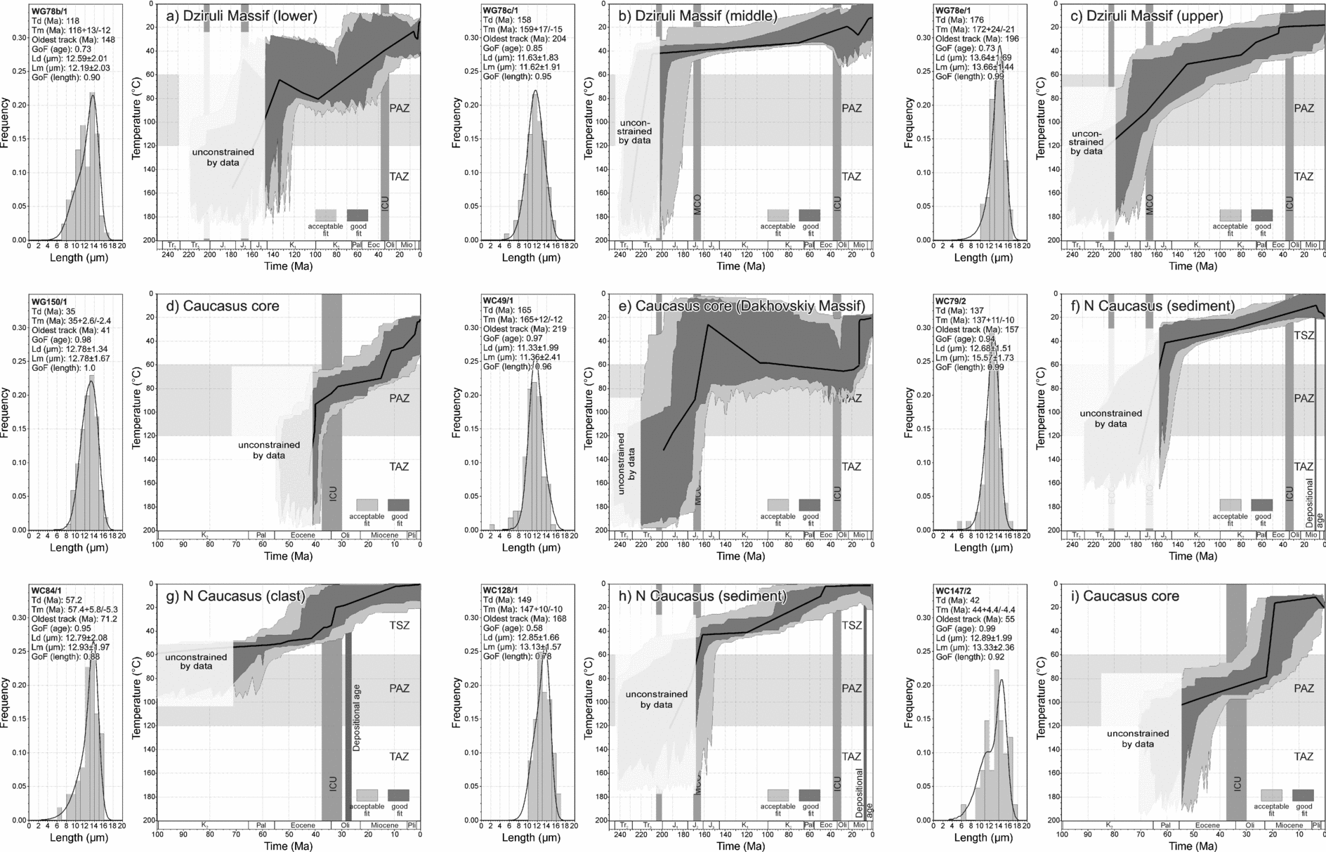
The FT and apatite (U–Th)/He analyses were carried out by the London Thermochronometry Group at University and Birkbeck College, University of London, UK, using the approaches outlined by Gallagher, Brown & Johnson (Reference Gallagher, Brown and Johnson1998) and Donelick, O'Sullivan & Ketcham (Reference Donelick, O'Sullivan, Ketcham, Reiner and Ehlers2005). Samples for FT analysis were mounted, polished, etched and then packed with muscovite external detectors and Corning glass dosimeters and irradiated in the well-thermalized (Cd ratio for Au > 100) Hifar Reactor at Lucas Heights in Australia. Fission-track densities were measured using an optical microscope at 1250× magnification with an oil objective. Ages (±1σ) were calibrated by the zeta method (Hurford & Green, Reference Hurford and Green1983). FT results are presented in Table 2, with AFT length data and radial plots being contained in the online Appendix (http://journals.cambridge.org/geo). The best-fit thermal models for the AFT data are presented in Figure 5 and were modelled using HeFTy (Ketcham in Ehlers et al. Reference Ehlers, Chaudhri, Kumar, Fuller, Willet, Ketcham, Brandon, Belton, Kohn, Gleadow, Dunai, Fu, Reiners and Ehlers2005), taking into account apatite sample composition.
Apatite and zircon fission track results
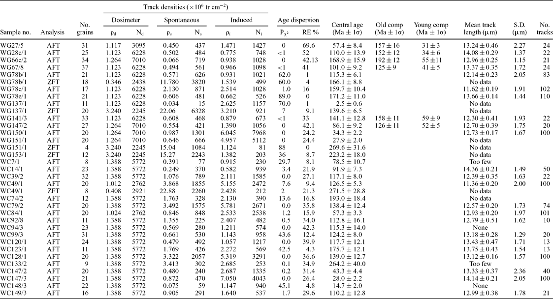
Analyses by external detector method using 0.5 for the 4π/2π geometry correction factor.
Ages were calculated using dosimeter glass CN-5; (apatite) ζCN5 = 338±4; CN-2 (zircon) ζCN2 = 127 ± 4 calibrated by multiple analyses of IUGS apatite and zircon age standards (see Hurford, Reference Hurford1990).
Pχ2 is probability for obtaining χ2 value for v degrees of freedom, where v = no. crystals − 1.
Central age is a modal age, weighted for different precisions of individual crystals (see Galbraith & Laslett, Reference Galbraith and Laslett1993). Old and young compositional ages are determined using track length radial plot distributions (see Fig. A1 in online Appendix at http://journals.cambridge.org/geo).
Best-fit thermal models for AFT samples from the Dziruli Massif and western Greater Caucasus listed in alpha-numeric order. One hundred good thermal paths were obtained for each model. The approximate intervals of the ECO (early Cimmerian orogeny), MCO (middle Cimmerian orogeny) and ICU (initial Caucasus uplift) are shown, as are the approximate temperature ranges of the apatite TAZ (total annealing zone), PAZ (partial annealing zone) and TSZ (total stability zone). The dark and light shaded areas encompass 1σ (good) and 2σ (acceptable) confidence limits, respectively, and the lines correspond to the most probable thermal histories. Goodness of fit (GoF) gives an indication of the fit between observed and predicted values (values close to 1 are best). The geological timescale is from Gradstein, Ogg & Smith (Reference Gradstein, Ogg and Smith2004). For a colour version of this figure see the online Appendix at http://journals.cambridge.org/geo.
Three types of FT samples are distinguished: (1) crystalline/metamorphosed basement, (2) Mesozoic sedimentary rocks that contain fission tracks annealed after deposition, and (3) Oligo-Miocene sedimentary rocks (or crystalline clasts contained therein) that have not undergone significant post-depositional burial. The former two types are referred to as bedrock samples in the discussion below and record the thermal history of the sample's locations. The latter records the more regional and complex palaeothermal history of these sediments’ source areas prior to erosion and deposition. Palaeocurrent and provenance analyses indicate that these sediments were derived from the region of the present-day high Caucasus (Vincent et al. Reference Vincent, Morton, Carter, Gibbs and Barabadze2007). The geographic positions of all the FT samples are shown on Figure 2, along with a graphic representation of the FT cooling age of the bedrock samples and the lag time between the AFT cooling and depositional ages of the Oligo-Miocene sediment samples.
Sample cooling histories are converted to eroded crustal section (km) by dividing temperature loss (mineral closure minus surface temperature; °C) by average geothermal gradient (°C km−1). Mineral closure temperatures are dependent on cooling rates, were calculated using the CLOSURE program (Brandon in Ehlers et al. Reference Ehlers, Chaudhri, Kumar, Fuller, Willet, Ketcham, Brandon, Belton, Kohn, Gleadow, Dunai, Fu, Reiners and Ehlers2005) and are stated in the text. Rapid exhumation causes thermal advection, increased geothermal gradients and an overestimation of lost section due to denudation (Brown & Summerfield, Reference Brown and Summerfield1997). Erosion rate estimates were corrected for these effects using the AGE2EDOT program (Brandon in Ehlers et al. Reference Ehlers, Chaudhri, Kumar, Fuller, Willet, Ketcham, Brandon, Belton, Kohn, Gleadow, Dunai, Fu, Reiners and Ehlers2005). An average surface temperature of 10 °C is adopted.
Geothermal gradients derived from exploration wells along the margins of the western Greater Caucasus vary, depending on the age and lithology of the sedimentary succession (Sukharev, Taranukha & Vlasov, Reference Sukharev, Taranukha and Vlasov1964). They are generally lower on the southern side of the range (e.g. ~ 20–30 °C km−1 around Sochi and ~ 30 °C km−1 near Poti) than on the northern side (e.g. ~ 40–55 °C km−1 around Maykop and ~ 40 °C km−1 near Mineral'nyye Vody) (Sukharev, Taranukha & Vlasov, Reference Sukharev, Taranukha and Vlasov1964). A geothermal gradient of ~ 40–45 °C km−1 was calculated from borehole data within the Eldzhurtinskiy granite, in the northern part of the crystalline core of the range (Hess et al. Reference Hess, Lippolt, Gurbanov and Michalski1993; Gazis et al. Reference Gazis, Lanphere, Taylor and Gurbanov1995; Grün et al. Reference Grün, Tani, Gurbanov, Koshchug, Williams and Braun1999). An average geothermal gradient value of 40 °C km−1 is adopted here. This inevitably introduces uncertainty, and it results, for instance, in exhumation estimates being lower than if the global average of 30 °C km−1 were adopted (these values are also included in parentheses). Such estimates, however, are necessary if the relative magnitude of exhumation in the region is to be illustrated.
Apatite (U–Th)/He determinations were made on a single aliquot of two to four apatite grains, typically between 100–250 μ m long and 60–150 μ m wide. Evolved helium was spiked with 3He, and 4He/3He values were determined on a quadrupole mass spectrometer after quantitative He degassing of apatite at ~ 1000 °C for 30 min in a furnace. Grains were retrieved from the vacuum system, dissolved in HNO3, spiked with 230Th and 235U, and analysed for U and Th by Inductively Coupled Plasma Mass Spectrometry. Reported He ages have been corrected for alpha ejection effects based on measured grain dimensions (Farley, Wolf & Silver, Reference Farley, Wolf and Silver1996) using the procedure of Gautheron, Tassan-Got & Farley (Reference Gautheron, Tassan-Got and Farley2006). Each age typically comprises 3–4 replicates, the mean of which is reported in Table 3. The estimated analytical uncertainty for AHe ages based on the Durango age standard is 7 % (2σ). These are the default uncertainty values used on a sample unless the standard deviation from the sample replicate ages is higher, in which case the latter is used.
Apatite (U–Th)/He dating results from Oligo-Miocene sediment samples, West Georgian Greater Caucasus
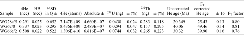
HB – Hot blank; FT is the grain dimension correction factor to account for helium lost by ejection of alpha particles.
Quartz for the detrital 10Be cosmogenic nuclide analysis was physically and chemically isolated by the Geochemical Group of the University of Bern, Switzerland, and then spiked with a known proportion of 9Be using a method simplified from von Blanckenburg, Belshaw & O'Nions (Reference von Blanckenburg, Belshaw and O'Nions1996). 10Be concentrations were then calculated using accelerator mass spectrometry at the PSI/ETH facility in Zurich, Switzerland, to determine the 10Be/9Be value and the concentration of Be in the quartz in a method described by Kubik et al. (Reference Kubik, Ivy-Ochs, Masarik, Frank and Schluchter1998). Predicted cosmogenic nuclide flux was adjusted for mean elevation, latitude and topography of the catchment area of the Inguri River upstream of the river sample site (WG21/1). The erosion rate derived for this sample and the area it relates to are shown on Figure 2.
5. Analytical data
5.a. Bedrock samples
5.a.1. Core of the western Greater Caucasus
Introduction. Six crystalline basement samples were analysed from the core of the western Greater Caucasus (Table 1; Fig. 2). Three were derived from its northern margin close to Mt Elbrus (samples WG150/1, WG151/1 and WG153/1). One sample was from the northwesternmost granodioritic body exposed in the western Greater Caucasus, the Dakhovskiy Massif on the Belaya River (sample WC49/1). The remaining two samples, although collected from the headwaters of the Mzimta River, were petrologically matched with Late Palaeozoic crystalline bodies at the southern margin of the crystalline core of the range (as shown on Fig. 2; samples WC147/2 and WC147/3). AFT analysis was carried out on all but sample WG153/1, while ZFT analysis was also carried out on samples WG151/1, WG153/1 and WC49/1 (Table 1).
Results. Sample WG151/1 yields an AFT central age of 28 ± 2 Ma (Table 2). However, because no confined track lengths were present, it is unclear if this age records the time of rapid cooling through the partial annealing zone (PAZ) or a more protracted history. For this reason the apatite in adjacent sample WG150/1 was also analysed. This gave an age of 34 ± 2 Ma and a mean track length of 12.73 ± 0.17 μm based on 100 measurements (Table 2). This age, although not identical to that obtained in WG151/1, is within 2σ error, and thus it is reasonable to assume both samples have experienced a similar thermal history. The track length distribution for sample WG150/1 is unimodal and relatively long (Fig. 5d). The lack of a tail of short tracks is consistent with a simple, fairly rapid cooling history.
The best-fit thermal model for sample WG150/1 displays a strong goodness of fit (GoF) to the analytical data (Fig. 5d). The sample displays a relatively uniform Oligocene to Present cooling path, although there may have been an increase in cooling from around 1 °C Ma−1 to 3 °C Ma−1 during Middle Miocene time (c. 15 Ma; Fig. 5d).
ZFT results for sample WG151/1, based on only four single grain ages, yield an imprecise cooling age of 270 ± 32 Ma (Table 2). A more precise ZFT age of 223 ± 18 Ma was obtained from sample WG153/1. When paired with the AFT cooling data, these ages record the relative thermal stability of the crystalline core of the western Greater Caucasus during Mesozoic and early Cenozoic time. Cooling from ~ 200 °C during Middle Permian–Middle Triassic time to ≤ 100 °C by the end of Eocene–middle Oligocene time is equivalent to an average cooling rate of ~ 0.5 °C Ma−1. These results also limit the amount of post-Eocene erosion possible to ~ 2.5 (3) km and discount the possibility of large magnitude rapid cooling around 40 Ma permissible in the AFT thermal modelling of sample WG150/1 (Fig. 5d).
Samples WC147/2 and WC147/3, collected from outcrops further to the west (Fig. 2), also have Palaeogene AFT central cooling ages of 43 ± 4 Ma and 28 ± 2 Ma, respectively. Thermal modelling of sample WC147/2 suggests relatively slow cooling during the Eocene and Oligocene epochs (~ 0.8 °C Ma−1). This was followed by an acceleration in cooling (~ 4–20 °C Ma−1) to near-surface temperatures that is most likely to have taken place during Early Miocene time (Fig. 5i). The early thermal history of this sample is poorly constrained, although the oldest modelled track age of 55 Ma provides some indication of when it began to pass through the partial annealing zone. The mean track length of sample WC147/3 is 14.14 ± 0.21 μm, which indicates rapid cooling through the FT partial annealing zone, such that the measured AFT age approximates to the time of this cooling (down to temperatures <~ 60 °C).
Sample WC49/1, from the Dakhovskiy Massif, yields AFT and ZFT ages of 127 ± 5 Ma and 272 ± 29 Ma, respectively (Table 2). Stratigraphic relationships indicate that the massif was deformed and unroofed during latest Triassic to earliest Jurassic time and Bathonian to early Callovian time during early and middle Cimmerian orogenic events (Melnikov, Srabony'an & Kokarev, Reference Melnikov, Srabony'an and Kokarev1994). The ZFT age determination, although not of high quality due to most grains having uncountable high track densities, is comparable with that from sample WG151/1. Combined with the stratigraphic evidence, this indicates average cooling of the western Greater Caucasus basement during Permo-Triassic times of ~ 3 °C Ma−1 and implies ~ 5 (6.5) km of unroofing of the massif during that time. The best-fit thermal model suggests that AFTs within sample WC49/1 were only partially annealed during heating to ~ 60 °C in the Late Jurassic–Early Cretaceous interval (explaining the sample's relatively old central age; Fig. 5e). Relatively rapid cooling to surface temperatures is modelled to have occurred sometime after Early Oligocene time.
5.a.2. Flanks of the western Greater Caucasus
Introduction. Four further bedrock samples were analysed from the flanks of the western Greater Caucasus (Table 1). On the southern flank of the range, a sample (WG137/1) was collected from metasediments of the Devonian to Triassic Dizi Series on the Tskhenis River, West Georgia. Another was collected from middle to upper Aptian sandstones along the Russian Black Sea coast between Sochi and Tuapse (sample WC39/2), and a third from Cenomanian sandstones on the Mzimta River (sample WC14/1; Fig. 2). A Lower Jurassic sandstone (sample WC120/1) was collected from the Mala Laba River on the northern flank of the range. AFT analysis was carried out on all four samples and ZFT analysis was also carried out on sample WG137/1. Insufficient track length data were available to model the cooling histories of these samples.
Results. Sample WG137/1 yields an extremely young AFT cooling central age (2.5 ± 0.6 Ma; Late Pliocene). If this age is assumed to record cooling due to exhumation it would imply rates of ~ 1.2 (1.6) km Ma−1. However, taking into account the effect of advection, the corrected exhumation rate is likely to be closer to 0.9 (1.1) km Ma−1 (Brandon in Ehlers et al. Reference Ehlers, Chaudhri, Kumar, Fuller, Willet, Ketcham, Brandon, Belton, Kohn, Gleadow, Dunai, Fu, Reiners and Ehlers2005). This is similar to the current erosion rates for the same structural zone obtained from the cosmogenic isotope analysis of river sands derived from the Inguri River catchment upstream of locality WG21 (sample WG21/1). This indicates an average lowering of the land surface by 60 cm over approximately the last 544 years which, if extrapolated to geological timescales, equates to a catchment-wide erosion rate of ~ 1.1 ± 0.3 km Ma−1.
The zircon phase of sample WG137/1 yields a well-defined fission track age of 140 ± 7 Ma. The 20 grains that were analysed form a single age population. The large difference between the ZFT and AFT ages for this sample signifies very recent cooling from temperatures above the apatite PAZ (that is, > 130 °C), but below the zircon PAZ (~ 200 °C for non-radiation-damaged zircon). This temperature range constrains the amount of recent exhumation to between ~ 3–5 km, based on a geothermal gradient of ~ 40 °C km−1.
Samples WC39/2 and WC120/1 yield Aptian AFT central ages (117 ± 8 and 118 ± 12 Ma; Table 2). The fact that these central ages are either similar or younger than their depositional ages suggests that the AFTs within these samples have subsequently been partially to totally annealed. Sample WC39/2 contains apatites with a spread in ages that are not clearly linked to grain composition and suggests that some grains retain a strong provenance signal. Although only 22 track lengths were measured, a short mean track length of 12.4 μm is consistent with an exit from the partial annealing zone more recently than the central age. The youngest, reset, grain ages at c. 50 Ma (Fig. A1; available in online Appendix at http://journals.cambridge.org/geo) suggest that the onset of cooling occurred at or soon after this time. Sample WC120/1 displays a spread of AFT ages and a good correlation to grain composition consistent with a slow cooling history. The youngest grains at around 50 Ma (Fig. A1) again point to the time of cooling below ~ 60 °C and departure from the partial annealing zone.
The apatites in sample WC14/1 come from an arkose that contains volcanic rock fragments and euhedral volcanic plagioclase feldspars. They yield a single age population and long track lengths (14.4 μm), indicative of rapid cooling at 92 ± 7 Ma. This is within error of its depositional age and is suggestive of a contemporaneous volcanic source for the apatite, consistent with the presence of pillow lavas of the same age that crop out ~ 40 km to the northwest.
5.a.3. Dziruli Massif
Introduction. Three samples were analysed from the crystalline basement of the Dziruli Massif. The samples were collected in a 650 m vertical transect and range from Middle Jurassic (sample WG78b/1) to Palaeozoic in age (samples WG78c/1 and WC78e/1; Table 1).
Map and field data indicate that the Dziruli Massif underwent a phase of Middle Jurassic (probably syn-Bajocian) granitic intrusion (including sample WG78b/1) and subsequent cooling, with the intrusions being deformed and exhumed around the Bathonian–Callovian stage boundary as part of the middle Cimmerian orogeny (Kandelaki & Kakhadze, Reference Kandelaki and Kakhadze1956; this study). The massif was deeply weathered and peneplained prior to onlap during Early Cretaceous time before being exhumed again during the Palaeogene period. This latter exhumation event is not well constrained, although stratigraphic relationships suggest it took place sometime between Middle Paleocene and middle Oligocene time. These events have been used to constrain the AFT thermal models discussed below.
Results. The samples yield AFT cooling central ages of between 171 ± 11 Ma and 115 ± 6 Ma (Bajocian to Aptian time; Table 2). Sample WG78b/1 has a ZFT age of 166 ± 9 Ma, while samples WG78c/1 and WG78e/1 lacked sufficient zircon for analysis. The intrusion of Middle Jurassic granites will have perturbed the thermal structure of the region and locally elevated its geothermal gradient. Nevertheless, the coincidence of the ZFT cooling age in sample WG78b/1 and AFT cooling ages in samples WG78c/1 and WG78e/1 necessitates rapid cooling of all samples during the Middle Jurassic epoch. The oldest tracks recorded by the modelling suggest that cooling may have been initiated around 200 Ma (Fig. 5).
The lowermost sample (sample WG78b/1) has the youngest AFT cooling age and a moderately short mean track length consistent with comparatively recent cooling from the partial annealing zone. Thermal modelling of the middle and upper samples provides a good fit with the analytical data (Fig. 5b, c). Both indicate that they have been at near-surface temperatures since Early Cretaceous time, consistent with their onlap by Valanginian–Hauterivian sediments. However, the samples do have different mean track lengths and modelled Jurassic cooling paths. Intermediate sample WG78c/1 is modelled to remain at upper crustal levels throughout the Jurassic period, despite evidence that the highest sample in the section cooled from around 120 °C during that time. This is explained by differences in apatite chemistry, with the intermediate sample (WG78c/1) containing lower levels of chlorine (Table A1; available in online Appendix at http://journals.cambridge.org/geo) and therefore being less sensitive to annealing (Barbarand et al. Reference Barbarand, Carter, Wood and Hurford2003). The lowest sample is modelled to have left the partial annealing zone after the other samples, consistent with its AFT cooling age and stratigraphic position. Although thermal modelling does not provide as tight a fit with the analytical data, it does suggest a degree of burial reheating during the Cretaceous period, prior to cooling in latest Cretaceous to Eocene time (Fig. 5a).
5.b. Oligo-Miocene sedimentary samples
5.b.1. Southern western Greater Caucasus
5.b.1.a. West Georgia
Introduction. Uppermost Oligocene to lower Upper Miocene sediments from the southern flank of the western Greater Caucasus in West Georgia were collected from two river sections: Tskhenis (samples WG66c/2, WG67/8 and WG141/3) and Chanis (samples WG27/5, WG28c/1 and WG147/2) (Table 1; Fig. 2).
Results. Samples from the Tskhenis and Chanis rivers yield AFT central ages of between 169 ± 16 and 57 ± 8 Ma (Bajocian to Thanetian time). However, these samples contain mixed AFT age populations that comprise two age components: an older peak ranging between 192 ± 12 and 125 ± 9 Ma (Sinemurian to Barremian–Aptian time) and a younger age ranging between 59 ± 9 and 31 ± 3 Ma (Selandian to Rupelian time) (Table 2; Figs 6, A1; Figure A1 available in online Appendix at http://journals.cambridge.org/geo). These modes are all significantly older than the sample depositional ages and suggest that little if any post-depositional annealing has taken place. This interpretation is reinforced by the observation that apatite grain compositions, although highly variable, show no systematic relationship between composition and single grain age that is diagnostic of post-depositional annealing. The two age modes are thus thought to represent two different source area cooling histories within the evolving Caucasus. Insufficient track length data were collected from each mode to determine specific thermal histories, thus we can only rely on the relationship between the measured cooling ages and sample depositional ages to infer differences in source area exhumation rate.
Time-lag plot between thermochronometric age and depositional age of sediments incorporated into Oligo-Miocene samples from the flanks of the western Greater Caucasus. See Figure 2 for the location of the sections from which the samples were collected. Note that two AFT age populations have been identified from the samples from the Chanis and Tskhenis rivers. The geological timescale is from Gradstein, Ogg & Smith (Reference Gradstein, Ogg and Smith2004).

Older apatite age populations. The principal AFT age modes within Cenozoic sedimentary rocks from West Georgia are > 100 Ma older than their depositional age (Table 2; Fig. 6). This indicates that sediment was derived from a thermally stable source region within the Caucasus that had experienced only minor denudation during the Cenozoic era. The samples have cooling ages that are similar to those from the Dziruli Massif (Table 2).
The apatites from sample WG66c/2 from the Tskhenis River section in West Georgia yield a (U–Th)/He as well as an AFT age date (Table 3). The euhedral apatites used for the helium analyses were largely associated with the older AFT age component and thus provide some additional insight into this age mode.
Sample WG66c/2 has an alpha ejection corrected (FT) helium age of 39.9 ± 0.2 Ma. This suggests a minimum cooling rate of ~ 40 °C in about 152 Ma between Early Jurassic and Middle Eocene time (~ 0.3 °C Ma−1), followed by 40 °C in about 25 Ma between Middle Eocene time and the sample's Early Miocene depositional age (~ 1.6 °C Ma−1). The euhedral nature of the apatites used in the helium analysis suggest that this is a reasonable assumption, although added complexities due to intermediate sediment storage may have affected the sample (see below).
Younger apatite age populations. The younger age modes are much closer to the sample depositional ages and, therefore, unless the apatites have a volcanic origin, they indicate a secondary source within the Caucasus that had experienced significant denudation sometime during Paleocene to Middle Miocene time (Table 2).
AFT ages generally increase with a decrease in the depositional age of the sediments from which they are derived (Fig. 6). This general trend may be the result of the chance sampling of apatites with differing thermal histories during changes in the catchments of the sediment supply systems that deposited the sandstones sampled in the Chanis and Tskhenis river sections. However, the trend would seem to be too systematic for this to be the case. If it is assumed that crust with the same thermal structure was eroded throughout, then the only way in which progressive erosion could generate cooling ages in detrital apatites that are progressively older up-section is if the cooling age structure had been inverted. It is highly unlikely that this could be achieved tectonically, as this would involve the overturning of an unreasonably large crustal unit while not heating the base of the unit much above 60–90 °C to cause significant track annealing. Instead, this pattern is thought best achieved through the involvement of intermediate sediment storage prior to deposition in the sections sampled. This is illustrated schematically for samples from the Tskhenis River section in Figure 7. Significant amounts of reworked Eocene microfauna and flora within the sampled sections in West Georgia support this hypothesis.
Model to explain the inverse relationship between depositional age and AFT age (see Fig. 6) for Miocene sediments from the Tskhenis River, West Georgian Greater Caucasus. This involves the inversion of the stratigraphy through an intermediate (most likely Eocene) sediment storage site.

The three oldest depositional samples in the region display the shortest lag times and are therefore likely to have been least affected by intermediate sediment storage. Sample WG67/8 from the Tskhenis River yields the shortest lag time (20 Ma) for samples from this section (Fig. 6). Samples WG28c/1 and WG27/5 from the Chanis River section both display a 10 Ma time lag between their fission track cooling age and depositional age (Fig. 6), suggestive of steady state exhumation of the primary Caucasus source area averaging 10 °C Ma−1. Furthermore, the near contemporaneity of the depositional and (U–Th)/He age of sample WG28c/5 indicates that the source was affected by episodes of rapid cooling in Late Oligocene time, probably in excess of 20 °C Ma−1. As there is no clear relationship between apatite grain morphology and age it is unclear which FT source age modes the (U–Th)/He data relate to. Nevertheless, denudation must have been short lived and must not have exceeded ~ 2 km, otherwise the FT ages would also be expected to be much closer to the depositional age.
It is unclear which FT age mode the apatites used for the (U–Th)/He age determination of sample WG67/8 are related to. The alpha ejection corrected (FT) helium age of 49.5 ± 0.1 Ma is older than the younger FT age component (41 ± 5 Ma) (Tables 2, 3; Fig. 6). Therefore the apatites are either related to the older of the AFT age modes and display a similar cooling history to sample WG66c/2, or represent apatites from the younger age mode that have been affected by helium implantation from adjacent U/Th-bearing grains.
5.b.1.b. Russia
Introduction. Six samples from the Oligo-Miocene succession from the Mzimta River/Sochi region were analysed (WC7/1, WC92/8, WC94/3, WC99/3, WC148/3 and WC149/3) in order to test whether a similar exhumation signature to the West Georgian western Greater Caucasus was apparent in this region (Table 1; Fig. 2).
Results. Only single AFT age populations were identified in Oligo-Miocene sedimentary samples from the Russian western Greater Caucasus (Fig. A1). There is no apparent correlation between apatite chemistry and age, such that post-burial annealing is thought to have been minimal; intra-sample variations in AFT age are therefore likely to be dominated by variations in source area thermal history. Central ages range from 124 ± 8 to 15 ± 2 Ma, with the majority of the samples having ages between 125 and 110 Ma that are indicative of a relatively stable Caucasus sediment source (Table 2; Fig. 2). Evidence for Oligocene and younger exhumation is not apparent in the majority of the samples, although a lack of sufficient track lengths or apatite grains meant that it was not possible to model the thermal history of these samples or carry out lower temperature helium analysis.
Pontian sample WC148/3 does, however, display a young AFT age of 15 ± 2 Ma (Table 2). Apatites were extracted from a single granite clast within a conglomeratic unit and record the thermal history of the crystalline core of the western Greater Caucasus prior to c. 5 Ma. The granitic source material took a maximum of 9.5 Ma to cool from ~ 120 °C and be eroded, resulting in similar average exhumation rates as Maykopian samples WG27/5 and WG28c/1 from West Georgia (Fig. 2).
5.b.2. Northern western Greater Caucasus
Introduction. Sandstones are rare within the outcrop stratigraphy on the northern side of the western Greater Caucasus. Five samples were analysed ranging from Early Oligocene to Meotian in age (Table 1; Fig. 2).
Results. Unroofing of the crystalline basement of the westernmost Russian Greater Caucasus by at least middle Oligocene time resulted in granitic clasts (among others) being incorporated into a conglomerate at the base of the Middle Maykopian Series in the Pshekha River. Such a clast (sample WC84/1) yields an AFT central age of 57 ± 3 Ma, with only limited evidence for post-depositional annealing. Thermal modelling yields a moderate match with the analytical data and suggests that rapid cooling from around ~ 50 °C was initiated some time from the Middle Eocene onwards.
The four other samples were taken from the Maykopian to Meotian succession on the northern side of the western Greater Caucasus. The central ages of all these samples range between 193 ± 12 and 138 ± 12 Ma (Table 2) and are similar to those within sediments from the southern side of the western Greater Caucasus. There is no correlation between apatite composition and age, suggesting limited post-depositional annealing, so that the AFT ages are likely to reflect the cooling age and relative thermal stability of the source material. Samples WC74/2 and WC123/1 represent single age populations, while in samples WC79/2 and WC128/1 the main apatite population age is around 165 Ma, although a number of younger grains are also present (Fig. A1, available in online Appendix at http://journals.cambridge.org/geo). These latter samples contain sufficient track lengths for these to be modelled (Fig. 5). Thermal modelling provides a close to moderate fit with the data and suggests that both samples were at upper crustal levels by the Late Jurassic epoch and underwent a protracted cooling history during Cretaceous and Cenozoic time (Fig. 5f, h).
6. Towards an integrated exhumation history of the western Greater Caucasus
The 39 new thermochronometric results detailed above cannot be expected to provide a complete picture of the complex geodynamic evolution of the western part of Europe's largest mountain belt. Nevertheless, when combined with other geological data a number of new insights are apparent.
6.a. Permian–Early Cretaceous
The Permian–Early Cretaceous evolution of the Greater Caucasus region is complex. Decreases in the intensity and/or changes in the style of deformation within rocks across major unconformities and the creation or changes in the geometry of discrete sedimentary packages have been used to define a series of orogenic and basin forming cycles (e.g. Nikishin et al. Reference Nikishin, Ziegler, Panov, Nazarevich, Brunet, Stephenson, Bolotov, Korotaev, Tikhomirov, Ziegler, Cavazza, Robertson and Crasquin-Soleau2001), irrespective of whether the precise nature of these events and their driving mechanisms are fully understood (Saintot et al. Reference Saintot, Brunet, Yakovlev, Sébrier, Stephenson, Ershov, Chalot-Prat, McCann, Gee and Stephenson2006a,Reference Saintot, Stephenson, Stovba, Brunet, Yegorova, Starostenko, Gee and Stephensonb).
ZFT analyses of samples from the central western Greater Caucasus yield Early–Middle Permian boundary and Middle Triassic cooling ages (samples WG151/1, WG153/1 and WC49/1; Table 2). When paired with the Early Oligocene AFT ages derived from the Mt Elbrus region (samples WG150/1and WG151/1), this indicates relatively slow average cooling rates of the order of 0.5 °C Ma−1 during much of Mesozoic and early Cenozoic time. Additional stratigraphic constraints, however, can refine this time–temperature pathway during the Mesozoic era in the northern part of the central western Greater Caucasus. Here, onlap patterns indicate that the Dakhovskiy Massif was exhumed by earliest Jurassic time, so that cooling from the zircon PAZ to surface temperatures occurred during Middle Permian to end-Triassic time. This would imply ~ 5 (6.5) km of unroofing of the massif during this time and an increased average cooling rate of around 3 °C Ma−1. Clearly, cooling rates could have been even higher if much of the exhumation was restricted to particular episodes within the Permo-Triassic epochs. For instance, detailed mapping of the Dakhovskiy region by Gaetani et al. (Reference Gaetani, Garzanti, Polino, Kiricko, Korsakhov, Cirilli, Nicora, Rettori, Larghi and Palliani2005) suggests that much of the exhumation occurred during the late Olenekian to Anisian stages (latest Early to Early Middle Triassic time), a period of less than 10 Ma.
A regional unconformity between more deformed Bathonian and older strata and less deformed Callovian and younger sediments is developed along the flanks of the western Greater Caucasus (Fig. 3) and around the Dziruli and Loki massifs further south. This deformation event is termed the middle Cimmerian orogeny (marked MCO on Fig. 5). Best-fit thermal modelling is consistent with rapid cooling in a number of samples during this tectonic event (Fig. 5). Most AFT samples, however, collected from basement units or from clasts derived from these units, have central ages that are younger than this exhumation event. This implies either that the samples had not exited the PAZ for apatite during the Middle Jurassic epoch or that some degree of partial annealing had occurred during reburial in the Late Jurassic to Palaeogene epochs (as modelled for samples WG78b/1 and WC49/1; Fig. 5a, e). The latter must be the case for Lower Jurassic sediment sample WC120/1. In a similar thermochronometric study of the Crimea Mountains, Upper Triassic to Upper Jurassic sediments and volcanic rocks were shown to have passed back into the total annealing zone (TAZ) of apatite sometime between Early Cretaceous and Late Eocene time (Pánek et al. Reference Pánek, Danišík, Hradecký and Frisch2009).
Oligo-Miocene sedimentary samples derived from the central western Greater Caucasus typically display AFT ages that are significantly older than their depositional ages, with the majority of samples possessing Late Jurassic and Early Cretaceous cooling ages (Fig. 6). This again implies that the material later incorporated into these samples either cooled through the apatite PAZ during these epochs or that older tracks were partially annealed during Late Jurassic to Paleocene time.
6.b. Late Cretaceous–Eocene
Few samples provide thermochronometric evidence for cooling events during Late Cretaceous to Eocene time. Apart from sample WC14/1, which contains contemporaneous apatites, it is notable that only one sample yields apatites with a central age between 100 and 60 Ma (Late Cretaceous to Middle Paleocene time). This may reflect the relative thermal stability of the region during this period, something apparent in the thermal modelling pathways of Figure 5.
Six samples have latest Selandian to latest Lutetian AFT central or subpopulation ages (Table 2), and two U–Th/He analyses yield late Ypresian to earliest Bartonian ages (Table 3). Two samples contained sufficient tracks to be modelled. Of these, basement sample WC147/2 contains no evidence for anomalous cooling prior to the Miocene epoch (Fig. 5i). The other sample (WC84/1) comprises a granitic clast within an Upper Oligocene conglomerate on the Pshekha River that was probably derived from crystalline basement in the northwestern Greater Caucasus. Modelling suggests that this region underwent accelerated cooling sometime from Middle Eocene time (Fig. 5g), although it is possible that most of this occurred during Early Oligocene time, immediately prior to its exhumation, erosion and redeposition (see below).
Four of the six sedimentary samples from West Georgia in which AFT subpopulations have been identified yield a latest Selandian to latest Lutetian cooling age in the younger population (Table 2). Owing to the inverse relationship between their cooling and depositional ages noted earlier, samples WG66c/2, WG141/3 and WG147/2 at least must have undergone a period of intermediate sediment storage (most likely during Eocene time) prior to redeposition in the Miocene epoch (Fig. 7). Given their complex history of reworking, exhumation must have been much more rapid than indicated simply by the time lag between their cooling and depositional ages. The short mean track lengths of sediment samples WC39/2 and WC120/1 indicate that they exited the PAZ for apatite well after their central ages, with their youngest grain ages possibly indicating that this occurred during Early Eocene time.
A Middle Paleocene to middle Oligocene hiatus within a thin stratigraphic carapace to the Dziruli Massif suggests that the massif was at near-surface temperatures at this time. The best-fit thermal model of the lowermost Dziruli Massif sample (sample WG78b/1) is compatible with this cooling having been initiated in latest Cretaceous time (Fig. 5a). Exhumation of the Dziruli Massif may be the result of footwall uplift at the margins of the adjacent transtensional Adjara–Trialet basin or the more regional effects of the opening of the Eastern Black Sea and/or the closure of northern Neotethys.
6.c. Oligo-Miocene to Present
Best-fit thermal history models of basement samples from the crystalline core of the western Greater Caucasus all indicate Oligo-Miocene cooling events (Fig. 5d, e, i). The resolution of these events is not well constrained, although it would appear that cooling was most pronounced during the Miocene epoch.
Lag times between cooling ages and depositional ages of Oligo-Miocene sedimentary samples derived from the western Greater Caucasus are also instructive. As noted earlier, within many of the subpopulations an increasing lag time with decreasing depositional age suggests secondary storage and recycling. Nevertheless, the minimum lag times for each subpopulation (generally the oldest depositional samples) provide some insights. The oldest (Early Oligocene) samples from the Mzimta and Pshekha rivers display AFT central age lag times in excess of 40 Ma and 20 Ma, respectively (Fig. 6), although as noted above, thermal modelling of the latter sample (WC84/1) does indicate that the majority of this cooling occurred immediately prior to exhumation and deposition (Fig. 5g). Late Oligocene–Early Miocene samples from the Chanis River have AFT lag times of about 10 Ma, with an (U–Th)/He age from the older of the samples indicating that this sample also underwent near-instantaneous cooling from around 40 °C prior to deposition (Fig. 6). A granite clast from Pontian (uppermost Miocene) conglomerates from the Mzimta River region also yields an AFT lag time of about 10 Ma, this being equivalent to ~ 0.25 (0.33) km Ma−1.
In general, the AFT central ages of bedrock or modern sediment samples yield Oligocene or older cooling ages that are greater than the shortest lag times of the Oligo-Miocene sediment samples reviewed above. This indicates a possible slow-down in cooling rates during Plio-Pleistocene time and runs counter to climate-driven increases in denudation rate observed in the European Alps (Cederbom et al. Reference Cederbom, Sinclair, Schlunegger and Rahn2004; Vernon et al. Reference Vernon, van der Beek, Sinclair and Rahn2008) and elsewhere (Zhang, Molnar & Downs, Reference Zhang, Molnar and Downs2001; Molnar, Reference Molnar2004). The only exception to this is sample WG137/1 from the Tskhenis River that yields an extremely young AFT cooling central age (2.5 ± 0.6 Ma; Late Pliocene), equivalent to exhumation rates close to 0.9 km Ma−1. This is very similar to the average current exhumation rates of a 2852 km2 area of the upper reaches of the Inguri River, upstream of the site from which cosmogenic sample WG21/1 was collected (Fig. 2). Old ZFT ages from WG137/1 suggest that the amount of exhumation for this sample was ~ 3–5 km, so that it is unlikely that these rates were initiated prior to the Pliocene epoch at the earliest. Combined ZFT and AFT cooling ages from samples from the crystalline core of the WCG close to Mt Elbrus indicate that Cenozoic exhumation here is unlikely to have exceeded ~ 2.5 km.
7. Discussion
Possibly the most striking finding of this study is the high rate of cooling/exhumation currently occurring in northwest Georgia (samples WG21/1 and WG137/1; Fig. 2). This is all the more surprising given the general lack of significant seismicity and low GPS-derived convergence rates (Fig. 1). Due to uncertainties over the extent of this zone of rapid exhumation, two geodynamic scenarios are possible.
(1) The exhumation event may represent the ‘pip-like’ expulsion of the largely Jurassic fill of the Greater Caucasus basin between the basement blocks of the Dziruli Massif (and its westward subsurface continuation) and the crystalline core of the western Greater Caucasus (Fig. 8). Despite the paucity of significant seismicity within the study region, the largest instrumentally recorded earthquake in the Caucasus occurred in April 1991, immediately to the east of the area of known high exhumation (the Racha earthquake; Ms = 7.0; Fig. 2). Fault plane solution analysis of this event and its aftershocks indicate that it occurred on a thrust fault dipping NNE at 20–31° either within the basement of the Dziruli Massif or between the massif and overlying Jurassic sediments (Triep et al. Reference Triep, Abers, Lerner-Lam, Mishatkin, Zakharchenko and Starovoit1995). This may mark the base of this rapidly exhuming zone (Fig. 8). Due to political tensions, we have not been able to sample either further west (Abkhazia) or east (South Ossetia) to test whether similar rocks in these areas are undergoing equally rapid exhumation. Rates of exhumation are compatible with this being driven by active shortening.
Cartoon showing a possible mechanism for the present-day rapid exhumation of the southern part of the western Greater Caucasus in West Georgia. Rates are in mm a−1 (km Ma−1) and are derived from Reilinger et al. (Reference Reilinger, McClusky, Vernant, Lawrence, Ergintav, Cakmak, Ozener, Kadirov, Guliev, Stepanyan, Nadariya, Hahubia, Mahmoud, Sakr, ArRajehi, Paradissis, Al-Aydrus, Prilepin, Guseva, Evren, Dmitrotsa, Filikov, Gomez, Al-Ghazzi and Karam2006) and this study.

(2) Rather than forming the backstop to exhumation, earlier thermochronometric studies suggest that the core of the western Greater Caucasus between Mt Elbrus and Mt Kazbeg is also undergoing rapid exhumation (Fig. 2). AFT analysis of crystalline samples in this region are ongoing to test this hypothesis. If correct, what is not clear is why this rapid exhumation does not occur to the west of Mt Elbrus. Král & Gurbanov (Reference Král and Gurbanov1996) proposed that activity on a major NNE–SSW basement fault was responsible for the marked change in AFT ages that they recorded on either side of Mt Elbrus. They claimed that this structure could be traced to the region of Mineral'nyye Vody. However, there are no clear structure(s) apparent in the surface geology of the western Greater Caucasus that can be attributed to this feature or evidence for seismicity along this trend (Figs 1, 2). As is the case further south, known GPS-derived shortening rates could provide a plausible driving mechanism if high exhumation/uplift rates are present in the core of the Caucasus to the east of Mt Elbrus.
Lithospheric delamination of the root of the Greater Caucasus has been postulated as a cause for large-scale (aseismic) uplift (Ershov et al. Reference Ershov, Brunet, Korotaev, Nikishin and Bolotov1999). However, tomographic data suggests that a negative velocity anomaly is only strongly developed beneath the Greater Caucasus at and to the east of Mt Kazbeg (Zor, Reference Zor2008), east of the study region. Isostatic uplift in response to post-orogenic focused denudation (cf. Champagnac et al. Reference Champagnac, Molnar, Anderson, Sue and Delacou2007; Vernon, van der Beek & Sinclair, Reference Vernon, van der Beek and Sinclair2009) is also discounted as a possible mechanism for the identified region of high exhumation due to the relatively small area affected and the high exhumation gradients necessary.
8. Conclusions
This thermochronometric study is consistent with previous work on the broad-scale tectonostratigraphic evolution of the western Greater Caucasus, with Cimmerian and Alpine cooling events being identified during Triassic to Middle Jurassic and Oligo-Miocene times, respectively (Fig. 9). Further work is needed to place the cooling and uplift of the Dziruli Massif within the complex Paleocene–Eocene tectonic evolution of the Tethysides and to test the significance of Eocene AFT cooling ages from samples situated along the southern margin of the western Greater Caucasus. The inverse relationship between AFT cooling age and depositional age of many of the Oligo-Miocene sediment samples, however, implies that some degree of Eocene erosion and intermediate sediment storage is likely.
Schematic summary of generalized western Greater Caucasus cooling paths identified in this study. SGC – southern Greater Caucasus.

The thermochronometric data are not sufficiently detailed to be able to better constrain time–temperature pathways during the Alpine transpressional evolution of the range, other than to confirm general Oligo-Miocene cooling and identify a number of pulsed events during this evolution. An increase in Plio-Pleistocene exhumation rates is not supported by the predominance of relatively old AFT ages obtained in this study. An exception to this is in northwest Georgia, where the region south of the crystalline core of the range has undergone rapid exhumation of ~ 1 km Ma−1 from possibly the Pliocene epoch onwards. Additional analyses are needed to test whether this is also the case within the core of the range east of Mt Elbrus.
In addition to constraining the timing of events, approximate amounts of cooling, and therefore exhumation, can be derived from the dataset. For instance, the ZFT age from a massif situated at the northern margin of the crystalline core of the western Greater Caucasus (that was unroofed by the end of the Triassic period) requires substantial amounts (~ 5 km) of Permo-Triassic exhumation. In contrast, cooling ages from the core of the western Greater Caucasus to the west of Mt Elbrus restrict the overall amount of Cenozoic exhumation here to ~ 2.5 km and reflect the relative thermal stability of the region since Late Jurassic to Early Cretaceous time.
Acknowledgements
This research would have been impossible without the field assistance of Lara Voronova and the support of CASP's industrial sponsors. Mike Simmons, Simon Inger, the late Robert Nadirashvili, Tanya Kalatch, Tanya Pinchuk, Tanya Mikerina, Vladimir Shishov, Viktor Sytnik and Li Guo are also thanked for their company and expertise in the field. We are grateful to Mirjam Schaller, Friedhelm von Blanckenburg and Peter Kubik for the cosmogenic analysis of sample WG21/1 and Robin Clayton for the helium analysis of samples WG28c/5, WG66c/2 and WG67/8. Prof. Poporadze (Tbilisi) provided samples WG150/1, WG151/1 and WG153/1 from his own collection and the use of this material is gratefully acknowledged. Robert Scott and Hugh Sinclair are thanked for their helpful comments on the manuscript, as are Aline Saintot and a further anonymous reviewer. This is Cambridge Earth Sciences contribution esc.1323.


