
Many of the cartographic and environmental terrains gathered under the area studies rubric of the Middle East and North Africa are seismic zones. Geological study defines seismic zones as areas where earthquakes tend to focus and classifies these zones into different levels of seismic hazard.Footnote 1 World maps of seismic hazard show differently colored bands sweeping across the globe (Fig. 1). A continuous swath of varying colors winds across the northern coast of Africa, with the yellows, oranges, and reds that indicate increasingly elevated hazard concentrated on spans of the Middle and High Atlas Mountains, extending outward in greens and blues to surrounding plains and coasts. Long lines of orange and red trace the highest levels of hazard around Iran and Turkey. From there, some bands double back West across the northern Mediterranean. Others widen across the whole of central Asia, embrace the entire Pacific rim, and spill over Oceania. Interrupting the colored seismic zones are projections of nation–state borders, presenting a visual contrast between continuity and discontinuity that is suggestive of the way that seismicity may disrupt other geographical and conceptual terrains.
K. Johnson et al. Global Earthquake Model (GEM) Seismic Hazard Map (version 2023.1), June 2023, https://doi.org/10.5281/zenodo.8409647. Used for research purposes under CC BY-SA 4.0/CC BY-NC-SA 4.0.

In this article, I consider how literature inscribes seismicity’s disruptive power into an understanding of contiguous yet disjunctive North African landscapes as more-than-human ecologies.Footnote 2 I analyze the relationship between writing and seismicity in “earthquake literature” from North Africa. Major earthquakes, such as those in Algeria at Orléansville/el Asnam in 1954 and 1980, or in Morocco at Agadir in 1960, figure in a number of literary works from the region.Footnote 3 I focus on Tahir Wattar’s al-Zilzal (1974), one of the first Algerian novels in Arabic, published in William Granara’s English translation as The Earthquake (2000).Footnote 4 Al-Zilzal stands out in earthquake literature in that, on the surface, it is not principally concerned with representing specific, historical seismic events nor the testimony of survivors. I instead define earthquake literature not as a narrow historical subgenre, but as writing moved by and moving with seismicity. Scholarship on al-Zilzal has interpreted the titular earthquake as a political allegory of postrevolutionary Algeria cast in the language of Islamic eschatology.Footnote 5 In such readings, even the novel’s diegetic references to the 1947 earthquake in Constantine, Algeria, serve principally as a foil to the text’s metaphorical earthquakes. Yet I argue, with Alejandra Padín-Dujon, that earthquakes are never only metaphors in zones of seismic hazard, retaining “a particularly literal relevance for seismically active cities such as Constantine” even as they become “imbued with symbolic meanings such as social crises, paradigm shifts, and psychological ruptures.”Footnote 6 Taken a step further, this insight opens a way of thinking about the geological within the metaphorical, the nonhuman within human language, and, conversely language not only as the interplay of signs, but also as embedded in a material world of semiotics.
Theorizing the material entangle of geological and metaphorical earthquake action, I will argue that al-Zilzal’s formal and narrative features associated with literary modernity and political engagement may be recast as elements of what I call “earthquake language,” the language of a literature that moves with seismicity, elaborating the temporality of earthquakes by extending it in narrative. Reading the novel’s political and religious metaphors in earthquake language reveals aspects of the landscape otherwise buried in the depths of the earth. The indifference of these forces not only to the human, but also to the more-than-human ecologies on the surface, must open a new critical conversation with current questions about extractivism and climate change, as well as the conceptual frame of the Anthropocene.
Theorizing Seismicity in Literary Political Ecologies
To approach the terrain of seismic zones through earthquake literature by reading for seismicity within language, I adapt the theory of language materiality from linguistic anthropology. Drawing on Raymond Williams’s assertion that language is a “practical material activity,” Shalini Shankar and Jillian Cavanaugh view language “as a material presence with physical and metaphysical properties and as embedded within political economic structures.”Footnote 7 Language materiality considers meaning in relation to the material conditions of utterance, the medium of communication, and the material properties of language. Meaning emerges omnidirectionally, as language acts on and in the world.
The concept of language materiality enables an understanding of literature’s participation in the semiotic and material construction of the environment as “social natures.”Footnote 8 This concept developed in the multidisciplinary field of political ecology, which emerged out of the shift from a positivist to a constructivist conception of the environment. Political ecology defines “the environment as having an ontological basis and a dynamic role as an agent in its own right.”Footnote 9 Social nature designates the discursive and material coproduction of the environment by human and nonhuman forces.
Social nature is an effective framework for the dynamics of more-than-human ecologies, yet there are other forces that it does not readily accommodate. Seismicity is not only a nonhuman force, it is an inhuman force.Footnote 10 “Inhuman” in this sense does not mean antagonistic to human existence, but rather indifferent or indeterminate, preceding and persisting within the human. Seismicity is part of what philosopher Elizabeth Grosz calls “geopower,” or the powers of the earth that precede the emergence of life and persist within and beyond it. To the surface dimensions of social natures spread out as terrains across the globe, seismicity adds axes of depth and of geological time, not only in the frequent sense of the millennial eras of earth systems processes, but also in the rapid times of catastrophe that are often too fast for ecological, let alone human, action.Footnote 11
My reading that follows of earthquake language in Wattar’s al-Zilzal joins these concepts in what I call a literary political ecology. Literary political ecology locates literature in social natures and apprehends it as a discursive and material object, in both the worlds it inhabits and those it invents. Relative to ecocriticism, characterized by the relationship between “literature and the physical environment,” ecology indexes complex, more-than-human social and biophysical assemblages.Footnote 12 With regard to other “literary ecologies” (which variously span literary representations of ecological issues, reckonings with the materiality of environments, and ecologies instantiated in literary form), I retain the qualifier “political” to emphasize literature’s role as a cultural technology embedded in a social world that it apprehends, expresses, and shapes in its own fashion.Footnote 13
Reading literature as a mode of political ecology brings out its distinctive modes of engagement with social natures. Literary aesthetics and epistemology permit different ways of knowing and acting on the world. With regard to seismicity, as an inhuman force of geopower, earthquake language is a “geoaesthetics,” “an extraction from the universe and an elaboration on it.”Footnote 14 In earthquakes, humans perceive inhuman forces, but in such a way as to be unable to comprehend or reflect on them. But in the aftermath, Grosz posits, “there is time to reflect and collect oneself and to produce art” that elaborates on geopower because “the earth remembers […] it preserves everything.”Footnote 15 This interaction differs from archiving or memory, because what the earth preserves is inhuman, and what literature elaborates is an extension of an experience of the inhuman, rather than a memory of it.
Earthquake and Zilzal, between Metaphor and Materiality
Al-Zilzal is a satirical portrait of a corrupt cleric, Shaykh Abdelmajid Bu al-Arwah. Having amassed wealth and property through collaboration with the French during the colonial period, Bu al-Arwah tries desperately to protect his ill-gotten lands from the postcolonial state’s nationalization projects during the Agrarian Revolution.Footnote 16 The novel takes place over the course of a single Friday in Bu al-Arwah’s hometown of Constantine in eastern Algeria, where he has returned after a sixteen-year absence to seek out his alienated relatives in order to conceal his lands under their names. At the same time, the novel’s satire of reactionary forces also delivers critiques of the Algerian state and the ruling National Liberation Front, using a polyphonic narrative technique that juxtaposes its antihero protagonist’s direct and free indirect discourse with the calls, cries, and voices of the other inhabitants of Constantine.Footnote 17
Seismic force powers the novel’s language. It animates revolutionary metaphors of decolonization and socialist reform, as well as an eschatological metaphor of the end times. Upon his arrival in Constantine, Bu al-Arwah attends a Friday sermon where he hears the imam preach about the end times from Surat al-Hajj 22:1–2 and Surat al-Ma’arij 70:40–44.Footnote 18 Bu al-Arwah obsessively repeats and reworks these verses to call for literal divine retribution in response to political and social upheaval. I read these political and religious metaphors as earthquake language that is materially grounded: first, in the material urban and agricultural environments of postcolonial development and land reform, a political reordering of the earth destined to be overturned eschatologically; and second, in Bu al-Arwah’s body, which physically shakes and trembles from its experience of the seismic hazard zone that is Constantine’s cityscape.
A full understanding of earthquakes in al-Zilzal must begin with the geological, resituating the questions of literal and metaphorical interpretation by integrating the seismicity of the material environment. I will analyze two aspects of language materiality in al-Zilzal that relate to the more-than-human ecology of a seismic zone. The first has to do with its medium, as a novel in the generic sense and as a print book in particular. The second deals with the novel’s polyphonic narrative construction, in which a tumult of voices moves with the force of seismic waves. Reading al-Zilzal as earthquake language, moving with the inhuman force of seismicity, refigures the novel’s human moral economy of political reform and religious judgment, as well as Wattar’s own literary project of developing Arabic as the language of Algerian national expression in the form of a modern, novelistic literature.Footnote 19 Earthquake language senses the possibility of nonanthropogenic futures—even destructive ones. At the level of Algerian literature, earthquake language disrupts the identity supposed by the concept of a national language, whose construction is necessarily premised on exclusion, not just in reversing the colonial linguistic hierarchy that privileged French, but also of Amazigh languages, colloquial Arabic, or Judeo-Arabic.Footnote 20 Within the novel, earthquake language exposes the social violence perpetrated in the name of the nation or the divine that makes marginalized populations vulnerable to greater seismic risk.
Printing Earthquake Language
I begin with the print form of the book to highlight the materially and culturally situated ways that al-Zilzal realizes a specific vision of modernity and nationality in postcolonial Algeria. In this sense, written and print forms are not just vehicles for transmitting a message, but themselves the material culture of language.Footnote 21 Printed text displays material features that function semiotically.Footnote 22 At the time al-Zilzal was published in 1974, part of its success in developing a new Arabic-language Algerian literary practice depended on an evolving concern across the 20th century for the form of Arabic typography in relation to its highly developed manuscript tradition. Arabic printing was not a simple technological improvement on handwriting practices; instead, it had to reckon with manuscript and calligraphic practices whose semiotic capabilities had become integral to readers’ expectations, but were far too complex to recreate with printing technology that had co-evolved with Latinate scripts.Footnote 23 Attending to the semiotic expectations and understandings of the Arabic-reading market was of great material concern for printers and publishers. However, they were reliant on Western producers of typefaces, typesetting machines, and printing presses. These Western companies internalized the expectations of the Arabic-reading market in their own fashion.Footnote 24
The original printing of al-Zilzal uses a simplified typeface of the sort that had gained increasing currency beginning in the 1950s thanks to their use in newspapers. This particular face is typographically inelegant and shows a high degree of wear on the physical character forms in their imprint on the page.Footnote 25 These suggest a lack of financial means on the part of Wattar’s Beiruti publisher, Dar al-ʿIlm li-l-Malayin, despite the financial support of copublication with an Algerian state company.
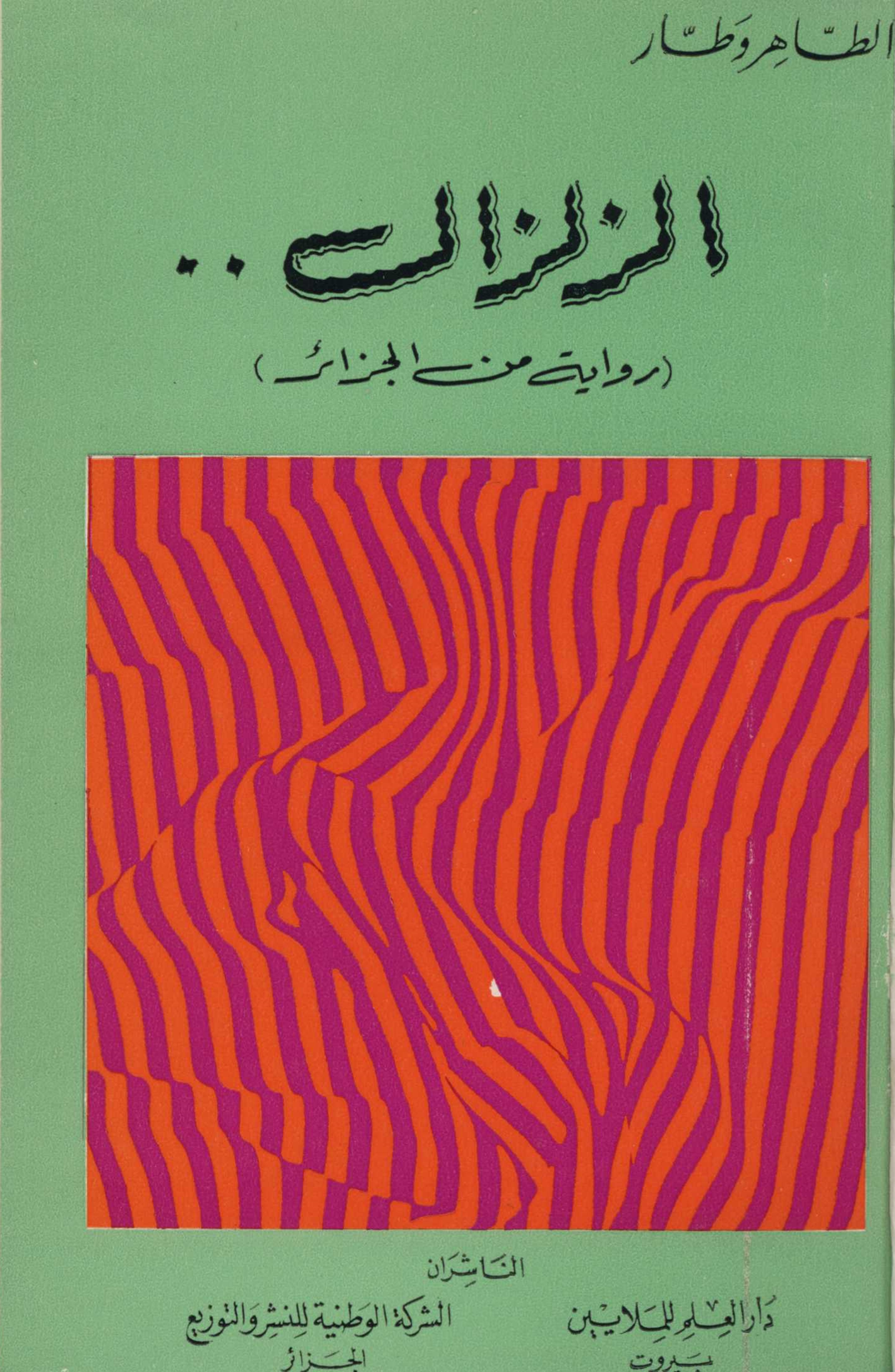
Distinctive, however, are the front cover and title pages (Fig. 2). The title is rendered in a simple script that is distorted by waves and doubled by a second, thinner line. This appearance would have been created by hand-lettering, rather than a standard typeface.Footnote 26 The word al-Zilzal is here inscribed in a visual form whose material properties function as signs.Footnote 27 The graphic rendering of the title realizes visually, by a producer and for an audience both especially primed to consider the semiotics of type beyond its linguistic semantics, what the diegetic language of the novel also expresses: the imprint of earthquake experience on bodily perceptions of the world they inhabit and the language which they utter to express it.
Cover of the original printing of al-Zilzal, copublished in Beirut and Algiers in 1974.

Narrating Earthquake Language
From the print form of the title on the cover to the narrative within and its political and religious metaphors, al-Zilzal is written in an earthquake language moving with and moved by seismicity as lived in the past, potential in every present moment, and feared for the future. This is language elicited by the bodily and terrestrial experience of sudden instability and uncontrolled movement that transforms shelter into exposure in an earthquake. It is therefore not only Bu al-Arwah’s understanding of the earthquake that is literal; it also is his experience of seismicity. His experience is not just personal or psychic, although it does have ramifications at those levels.Footnote 28 Rather, it is a material force that moves as the city teeters, Bu al-Arwah shakes uncontrollably, and Constantine’s polyphony resonates in seismic waves.
Seismicity manifests sensorially in Constantine’s built environment and geological situation, expressing their potential upheaval in an earthquake. The walls seem to lean on one another, rather than stand on their own; the rocky elevations beneath the city threaten to crumble. These sensations are heightened around Constantine’s famous seven bridges, which appear temporary, as though built for only a moment, given impending disaster (pp. 135–36). The teetering buildings, people on edge, and deep trembling that afflicts Bu al-Arwah’s body speak of a place and people marked by the latent potential for catastrophic tremors, which the narrative links by apposition of utterances and stream-of-consciousness, free indirect discourse.
Formally, the narrative resembles the hand-lettered title on the cover: Bu al-Arwah’s perspective is doubled, or rather multiplied, by the tumult of voices emanating from the jostling bodies crowding Constantine’s streets. The novel repeatedly describes these voices and bodies as mawjāt, waves. Paired provocatively with the novel’s title, these waves become mawjāt zilzāliyya, seismic waves. A key moment comes with a brief, unattributed dialogue between anonymous passersby, who evoke visceral memories of the earthquake that struck the city in 1947:
“I was a kid then and the only thing I remember were waves of people (mawjāt al-khalq) running away, screaming for help in different languages (jamīʿ al-lughāt).”
“I was about twenty, so I can still see it as though it was right in front of me. Hundreds and hundreds of children’s bodies were lying in the street. Some of them had been so stamped upon by the fleeing mobs that they looked like slabs of meat. Some of them were still moving and others weren’t injured at all. There were people running in great panic. I can still hear the pounding footsteps and the screams of women and children.” (pp. 165–66)
These unattributed voices transmit sonically the still-present aftershocks of an earthquake. These visual and aural memories record the transformation of an undifferentiated mass of people (the word khalq including the sense of humankind, in its collective identity as divine creation) into waves of flesh and cacophonous languages, screams, and pounding feet. Grammatically, the jumbled dialogue that Bu al-Arwah overhears as he navigates Constantine’s narrow streets, crowded squares, and dizzying bridges resembles his own free indirect discourse. Both employ the present tense, whereas the third-person narration uses the past tense. The wave, however, moves across these formal distinctions. The sound waves that carry the voices of passersby to Bu al-Arwah’s ears resonate in his body as much as his consciousness. After overhearing the description of the 1947 earthquake, Bu al-Arwah is caught in the force of this wave: “He was drowning in a wave of people (kāna al-mawj yadfaʿuhu) as he spoke out loud. Children followed him and laughed raucously at him, repeating every word he said” (pp. 167–68). The mocking echoes of Bu al-Arwah’s delirious words undo his illusory distance from the earthquake, as the wave, much less human in the Arabic than in the English translation, has moved from the language of the novel’s characters in the present tense into its narration in the past tense.
Through such formal manipulations of dialogue, free indirect discourse, and narration, al-Zilzal depicts the persistent action of seismicity on a human political ecology that is superficially incongruous with its subterranean depths and ephemeral. The Constantine cityscape and its inhabitants are all vulnerable to repetitions of this violent destruction by virtue of their geological situation, but it is the impoverished rural migrants to the city who are most exposed: climate refugees displaced by colonial deforestation and expropriation. Bu al-Arwah blames the state for their situation, while disdaining them internally and directly cursing them aloud. Yet in the novel’s polyphonic narration, the migrants respond. When a woman asking for money tries to grab Bu al-Arwah’s arm, the shaykh exclaims, “What a disaster! Where did they all come from? Why don’t you go all go back to your villages and deserts?” and she retorts, “May a disaster fall on your head! You talk as though you’re carrying us all on your shoulders” (p. 30). Bu al-Arwah shrugs her off, but cannot help imagining the potential of seismic disaster unfurling from beneath: “A rock is carrying us all, he thought, especially you and your kind. At every tide water does it damage. God knows how many holes are inside this rock, and at any moment, in its own peculiar way, it could cry out what a burden we all are” (p. 30). The interplay of dialogue and free indirect discourse reveals the exclusions and exposures of state practices and Bu al-Arwah’s reactionary critique, as he speculates that the masses cannot be Muslims, whether Arab or Amazigh, but rather stateless, nationless hordes sent to destroy the land (p. 47).
Even as other characters offer dissenting interpretations of the earthquake that obsesses Bu al-Arwah, it quickly becomes for him a physical experience rather than an intellectual metaphor. Moments after his encounter with the migrant woman, he experiences the internal upswell of a kind of dark magma oozing within his body, which also is increasingly affected from without by the vertiginous perspectives of the city’s precipices and bridges. Together, they cause uncontrollable tremors in his body, resonating with waves of voices that shake Bu al-Arwah to the core.
There are rich descriptions of the shaykh’s body affected by the city, shaking in even his most ordinary gestures: his sweat (p. 32), his stench (p. 33); his torso and butt shake (p. 33), his tongue hangs out (p. 35), his head lolls (p. 57), he trembles with fever and chills (p. 74). These physical reactions intensify as he gets lost and disoriented, and most of all when contemplating Constantine’s perilous perch above the Rhummel Gorge. Bu al-Arwah’s body and affect are both shaken by the phenomenological experience of the Constantine cityscape and its vulnerability to seismic activity, eliciting an earthquake language that perceives the earth itself as shaking: “He was so dizzy he felt as though the earth was moving beneath him” (p. 135). This is the language of peering over the edge, whether of a literal cliff or of a limited human conception of the environment, below which the unknowable and unpredictable threat of earthquake always looms, an inhuman geopower.
Bu al-Arwah’s delirium reaches its peak as he crosses the last two of the city’s seven bridges. There, the city and the novel resonate most forcefully with voices rendered in their most physical form as seismic waves. Content and form fuse in the polyphony of languages, chaos of bodies, and latent geological and architectural instability. Amid the voices and bodies that seem to crowd around Bu al-Arwah on the Bridge of the Abyss are apparitions of others, especially women and children, who were victims of Bu al-Arwah’s violent, murderous abuse that the novel has gradually revealed. As he swings wildly to fend off their phantasmal vengeance, he feels the earthquake, rendered narratively in the present, happening then and there (pp. 175–76). This narrative present tense renders this sensation as an effect of the place, more so than Bu al-Arwah’s individual circumstances. In these tremors, cacophonous earthquake language takes the form of seismic waves, the city’s indivisible plurality fused into a vibrant force, voices carried by the inhuman:
You can hear a roaring sound whenever you’re on top of the Bridge of the Abyss. If you listen very closely, you can imagine yourself hearing all of Constantine and everything that is going on in it. Whenever somebody is on the bridge, billions of waves rush towards it. Each wave carries with it the voice of a woman or a child, an old man or an animal, or a sputtering motor. The truth is that all of these voices can hardly be distinguished from one another. Even though these waves are separate from one another and flow in parallel lines, they still seem to overlap each other.
What’s different on the Bridge of the Abyss is that these roaring sounds have a huge effect on your heart. That’s because what the city is telling you from here has greater significance.
He felt a boiling sensation in his chest and the lava was flooding his insides. The dark gloom was blacking out everything around him. (p. 174)
Bu al-Arwah not only hears but feels and quakes with Constantine’s earthquake language. This virtual seismicity, like actual geological upheaval, disrupts sensation and intellection, and Bu al-Arwah must be restrained before the tremors throw him—or he throws himself—from the bridge. That it is the police who detain him does not signal the novel’s implicit approval of state projects over Bu al-Arwah’s reactionary and self-serving opposition. Any politics will confront the titular earthquake, which is not a specific event, but an inhuman force at the core of the novel’s moral economy, disrupting the distinction between the referential or metaphorical in its depiction of Algerian lands and bodies. Bu al-Arwah’s body is left literally shaking with an earthquake language that he fails to understand in relation to his environment.
Conclusion: Nonanthropogenic Futures
Reading al-Zilzal as “earthquake language” shifts focus from its political reception to the material, ecological embeddedness of this politics, especially as it relates to land reform. Bu al-Arwah’s anxieties, seismic and sociopolitical in origin and in their ramifications, send him on a quest through which the novel narrates a literary political ecology of postcolonial Algeria as an “earthquake society,” where seismicity is a constitutive element of the mutual interactions of environment and society, from the habitation, design, and regulation of built environments to everyday discourse and aesthetic production.Footnote 29 The seismic in earthquake literature reveals the illusory separation of society and nature.Footnote 30 “Earthquake language,” a linguistic and narrative assemblage of embodied voices in tumult, is particularly apt for rendering chaos and violence at the nexus of the natural and the political. The indistinguishable voices that seem to shake Constantine’s bridge with tremors speak of a city whose vulnerability to geological earthquakes and exposure to human upheavals are intimately related. In Constantine, the novel insistently observes, the risk of disaster is as much the effect of rural emigration, municipal urbanism, social conflict, and state policy.
Moreover, al-Zilzal is not only about territorial upheaval, by earthquake or by land reform. It is about the persistence of seismicity in the aftermath. It does not construct in retrospect a scaled-down, humanly comprehensible version of inhuman geopower. Instead, it elaborates the earthquake dimensions of inhuman, geological depth and speed into a novelistic power to dwell in a seismicity otherwise too-fast and too-deep. On the level of Wattar’s literary project of developing Arabic as a national language, “earthquake language” disturbs from below the exclusionary identity of language, nation, and territory. Furthermore if, on the political level with regard to land reform, the novel indicates the provisional nature of all territorializations, then this inappropriable geopower in Bu al-Arwah’s experience of seismicity is a sensation of future possibilities. The negative, destructive imagination of the future in al-Zilzal indicates the challenge involved, but Wattar wrote to advance a revolutionary project, not to cynically dismiss it. Accordingly, the inappropriability of geopower does not assert the vanity of all politics. Rather, it opens a totalizing, nihilistic metaphorization of politics with catastrophe in the Anthropocene to the inhuman, not as a morality tale about hubris, but to imagine futures that are never just anthropogenic.
Acknowledgments
I thank Brahim El Guabli and Edwige Tamalet Talbayev for their careful reading and editorial guidance, and for convening the panel that launched this cluster at the 2023 Middle East Studies Association Annual Meeting. I also thank Anna Levett, Ramyar Roussoukh, and Teresa Villa-Ignacio, who heard and responded to earlier versions of these arguments at MESA and at the 2025 Modern Language Association Convention. I am also grateful to Maria Stehle and Joe Witt for the opportunity to present this essay to the Just Environments faculty research seminar at the Denbo Center for Humanities and the Arts at the University of Tennessee, Knoxville.


 Open access