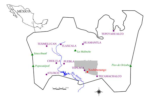
The Puebla-Tlaxcala Basin showing the location of the Formative Period site of Xochiltenango; the PAT survey area is shown shaded.

From 1994 to 1998, the Acatzingo-Tepeaca Project (PAT) conducted archaeological research in 560 sq. km in the area of the town of Tepeaca in the central Puebla-Tlaxcala Basin (Figure 1) situated in the central highlands of Mexico (Reference CastanzoCastanzo 2002: 96-100). This region is known to have been an important zone of cultural interaction historically and prehistorically among highlands peoples and between the highlands and the Gulf Coast (Berdan & Anawalt 1992:99; see also Garcia Cook 1981). Tepeaca itself was the seat of local Aztec political authority at the time of the Conquest in AD 1521 (Reference RojasRojas 1994) and its weekly market is still of macroregional importance (Reference GormsenGormsen 1978; Reference TyrakowskiTyrakowski 1978).
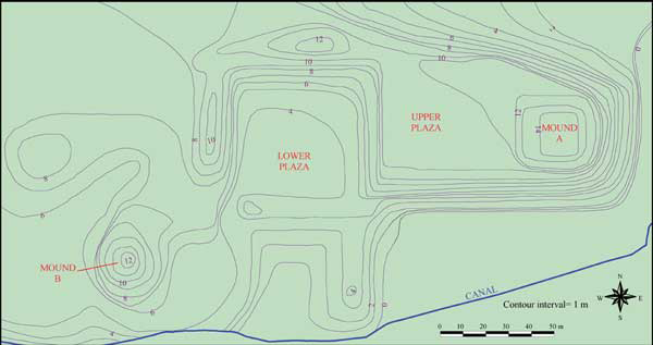
While data from the Classic and Postclassic periods are still being processed and integrated, dense Formative Period occupation has been identified. By the beginning of the Classic Period in AD 200, regional population had apparently reached more than 30 000. From an architectural standpoint, the most impressive Formative site found in the PAT survey is a large civic-ceremonial centre just to the east of the modern town of San Hipólito Xochiltenango, a few kilometres to the south-east of Tepeaca (Figure 2). The site boasts tens of thousands of cubic meters of construction involving two large temple and several platform mounds grouped around two plazas (Figure 3). The largest structure, Mound A, rises approximately 4 m above the Upper Plaza and more than 14 m above ground level (Figure 4). Today, much of the 2.5 ha civic-ceremonial zone is used as milpa (maize field) and an irrigation canal of unknown construction date cuts across its southern edge.
Topographic map of Xochiltenango; 0 m contour is approximately 2,150 m above sea level.

Photo of Xochiltenango taken from Mound B facing north-east.

Photo of Mound A facing north-east from the Upper Plaza.

Prehispanic settlement at Xochiltenango lay at the base of a range of low hills through which cuts the Barranca del Aguila, the largest local source of surface water flow. Much of the hillside to the north of the settlement has been subjected to substantial erosion exposing the underlying tepetate (a hardened calcareous substrate of volcanic origin) in many places and presumably the soil has been deposited in the immediate environs of the site. This colluvium, perhaps in addition to some alluvium from the barranca itself and associated canals, has probably obscured at least some evidence of prehispanic occupation around the site (especially with respect to the Late Formative for which fewer local ceramic markers are currently known) in particular to the west of the mound complex. Thus, the settlement was almost certainly significantly more extensive than reflected in the PAT data.
The PAT surface reconnaissance was conducted by teams typically composed of two archaeologists and four local workers usually spaced 25-35 metres apart forming a line perpendicular to the direction of the survey transect (Reference CastanzoCastanzo 2002:100-104). Evidence of prehispanic occupation was recorded on aerial photographs (1:5000 black-and-white or 1:8750 colour) in the field and transferred to transparencies in the laboratory located in Tepeaca. Surface collections of artefacts were also made in areas deemed locations of prehispanic settlement. Most collections were "general" and theoretically involved potentially diagnostic sherds representative of the history of occupation at a site; other collections were "intensive" and involved the gathering of all of the sherds (down to approximately one sq.cm) in a specified area (typically 3 by 3 m). While in many respects our understanding of local Formative Period ceramics is still developing, settlement in the vicinity of Xochiltenango (see below) was phased and mapped using 47 surface collections of potsherds (see Reference CastanzoCastanzo 2002:105-111 for a discussion of the methodology used in estimating Formative Period population). No excavations have been performed at the centre to date.
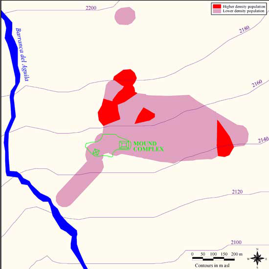
Middle Formative Period settlement within a 1 km radius of the Xochiltenango mound complex. Areas of "higher density" population contained 17-18 persons/ha, "lower density" areas contained 6-9 persons/ha.

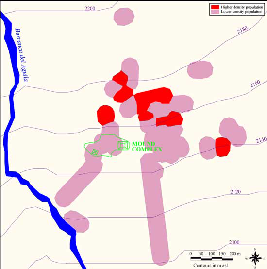
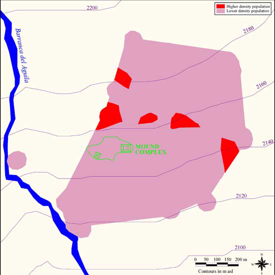
The available evidence indicates that the Middle Formative (950-550 BC) was the first period of significant human occupation at Xochiltenango (Figure 5), although nearby caves contain evidence of Early Formative (?-950 BC) use (see Medina Jaen 2001). During this time, the settlement within a 1 km radius of the mound complex had an estimated population of 189-399 and a total occupied area of 33 ha. This settlement can be subdivided into fairly distinct areas of higher density (17-18 persons/ha) and lower density (6-9 persons/ha). During this time (and in subsequent periods), the most densely occupied areas lay to the north and north-east of the civic-ceremonial zone, although one area of dense occupation was located approximately 700 m to the east. During the Late Formative Period (550-150 BC), the settlement grew slightly to an estimated 203-437 people and 34 ha (Figure 6). The Terminal Formative (150 BC-AD 200) was a time of significant population expansion throughout the Tepeaca area and apparently at the site of Xochiltenango as well as the settled area grew to 78 ha and the population swelled to 419-858 (Figure 7). After AD 200, the mound complex apparently fell into disuse, although settlement continued in the general area.
Late Formative Period settlement within a 1 km radius of the Xochiltenango mound complex. Areas of "higher density" population contained 17-18 persons/ha, "lower density" areas contained 6-9 persons/ha.

Terminal Formative Period settlement within a 1 km radius of the Xochiltenango mound complex. Areas of "higher density" population contained 17-18 persons/ha, "lower density" areas contained 6-9 persons/ha.

Elsewhere in the highlands of Mexico by close of the first millennium BC, state-level societies had emerged in the Basin of Mexico at Teotihuacán and Cuicuilco (Charlton & Nichols 1997; Sanders, Parsons, and Santley 1979:97-98,106), in the Valley of Oaxaca at Monte Alban (Flannery & Marcus 1983a,b; see also Blanton et al. 1993:79), and at Tlalancaleca in western Puebla-Tlaxcala (Garcia Cook 1976:40-41; Garcia Cook & Merino Carrion 1989:25-27). Central Puebla-Tlaxcala gave rise to no centres of such magnitude during the Formative Period, although settlements like Xochiltenango must have been important political centres with supporting populations perhaps numbering in the thousands. Future research is necessary before we can begin to describe the dynamics of the growth and development of the site. Initially, this research should include a regime of test excavations in a 200- to 300-metre-wide swath extending west from the civic-ceremonial zone to the barranca to identify the true extent of Formative settlement in addition to a series of trenches in the main architectural elements to gain a grasp on the sequence of construction at the mound complex.
Acknowledgements
The Acatzingo-Tepeaca Project was generously funded by the Mesoamerican Research Foundation. The field research would not have been possible without the permission and assistance of the Consejo de Arqueología and the Centro Regional de Puebla of the Instituto Nacional de Antropología e Historia of Mexico, not to mention the consent and co-operation of local governmental officials and private individuals. We also would like to thank Ken Hirth for all of his advice in data collection and preparation.