Introduction
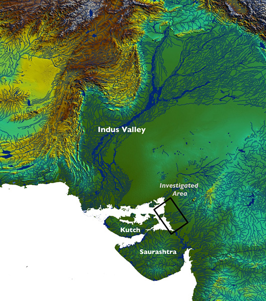
Archaeological survey recently conducted in north Gujarat (Figure 1) has revealed the existence of dozens of previously unknown Anarta, Sorath Harappan and Harappan as well as Mesolithic sites (Reference Ajithprasad and SonawaneAjithprasad & Sonawane 1994; Reference Ajithprasad, Yasuda and ShindeAjithprasad 2004). This 'peripheral' area of the Indus civilisation is of great potential for the understanding of land-use strategies, co-existence and evolution over time (Reference Ajithprasad, Yasuda and ShindeAjithprasad 2004; Madella & Reference FullerFuller 2006; Reference PatelPatel 2009). The importance of the area also lies in newly available evidence that argues for the occurrence of local cultivation systems based on native crops such as small millets (Panicum and Setaria) (Reference Fuller, Madella, Settar and KorisettarFuller & Madella 2001; Reference FullerFuller 2006). Furthermore, domestic cattle were part of the economy of north Gujarat as early as the beginning of the fourth millennium cal BC (Reference PatelPatel 2009: 177, tbl. 1) and the broad distribution of wild cattle in the north-west of south Asia suggests that there might have been local centres of domestication for this species. Remains of wild cattle were recently found during excavation within the Mesolithic deposits at Loteshwar (dated between the end of the eighth millennium cal BC and the middle of the sixth millennium cal BC), clearly suggesting that these animals were available to the local hunter-gatherer population (Reference PatelPatel 2009: 177, tbl. 1).
South Asia, the Indus Valley and the area of study in north Gujarat (rectangle).

The project
The Northern Gujarat Archaeological Project (NoGAP) is a new collaborative initiative between Spain and India, and promotes an interdisciplinary approach, integrating environmental, archaeological and ethnoarchaeological data for studying social contacts, resource use and cultural landscape in a long-term perspective. The programme includes:
-
1. The excavation of a set of key sites within north Gujarat to create a broad dataset from anthropic deposits.
-
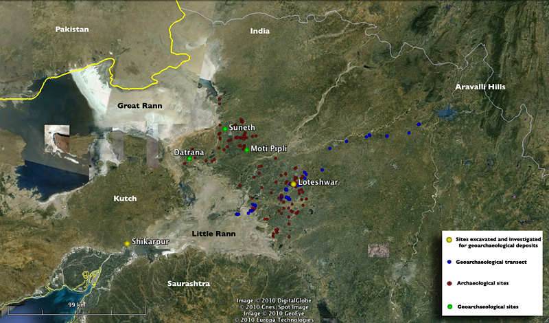
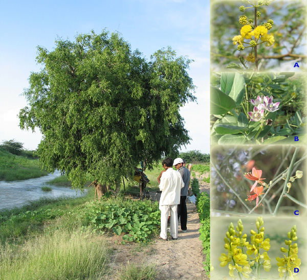
2. Extensive geoarchaeological (Figure 2) and vegetation surveys (Figure 3).
-
3. The systematic recovery of bioarchaeological remains (charred macros, charcoals, animal bones, phytoliths and starch) highlighting trajectories of domestication and human-environment interactions.
-
4. Sedimentological and micromorphological analyses to unravel site formation processes and taphonomy.
-
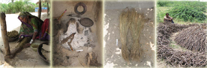
5. The study of traditional activities in contemporary pastoral and agricultural settlements to support the pattern recognition and analysis of site formation and activity signatures (Figure 4). Ethnoarchaeological work in north Gujarat has been carried out in Nagwada and Jhandala where crop processing and traditional building activities have been recorded and sampled for physical, chemical and residue (plant micro and macro-remains) analyses to create a signature dataset.
-
6. All information to be put together in a Geographical Information System (GIS) to analyse spatio-temporal relationships.
Distribution of north Gujarat archaeological sites highlighting the sites mentioned in text, the geoarchaeological sampling points and the geoarchaeological transect from the Little Rann of Kutch to the Aravalli hills.

Plant samples (wood, leaves, etc) for reference collection. Salvadora oleoides (main frame), Acacia nilotica (A), Calotropis procera (B), Capparis sp. (C), Cassia sophora (D).

Some of the activities, structures and materials recorded from the traditional villages of Nagwada and Jhandala. From left to right: wall/floor plastering, fireplaces, non-food plant products, production of charcoal for fuel.

First results
The first geoarchaeological reconnaissance and vegetation survey in north Gujarat took place in March 2008 and concentrated on the landscapes associated with four major groups of Mesolithic/Chalcolithic and Harappan sites (Figure 2): 1) Loteshwar in the Khari River Valley; 2) Moti Pipli in the Banas River Valley; 3) the Suneth to Datrana transect on the peninsula separating the Great and Little Rann of Kutch; and 4) the fortified Chalcolithic site at Shikarpur near the Great Rann.
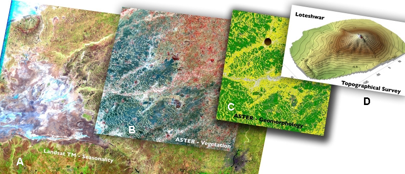
A second geoarchaeological reconaissance and sampling season was carried out in October-November 2009 focusing on: 1) the landscape surrounding Loteshwar and 2) the systematic surface sampling of soils and sediments across a 150km transept from the eastern edge of the Little Rann of Kutch to the foothills of the Aravalli Range for a preliminary geomorphological mapping (Figure 2). Remote sensing techniques were used to support the production of the geoarchaeological map (Figure 5) to detect and classify main land cover and landform characteristics, sediments, soils and ecological variability of the investigated area (Siart et al. 2008). All the heterogeneous data collected through the project's activities are integrated in a GIS to analyse environmental features and settlement patterns, as well as to reconstruct the archaeological landscape and model the resource exploitation strategies.
Example of different scale thematic maps produced to analyse the landscape characteristics and the resource distribution. The main land cover units, such as geomorphology, vegetation and land-use were identified using classification on Landsat and Advanced Spaceborne Thermal Emission and Reflection (ASTER) (pre-monsoon, monsoon and post-monsoon) imagery (A and B). The obtained classes are then integrated in GIS with Digital Elevation Model (DEM) data and topographical information obtained from Soviet military topographic maps and CORONA imagery (C). Finally, detailed topographical survey (D) of investigated sites are also added in a multi-scalar perspective. The example in here is the topographical survey of the dune (contour line 0.2m) with the excavated site of Loteshwar (red square).

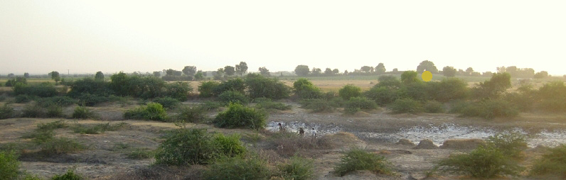
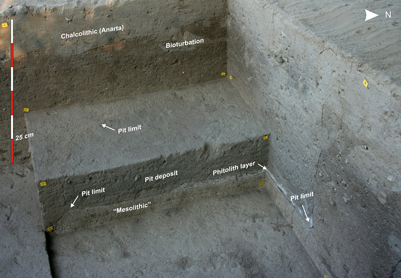
The first site to be investigated within the NoGAP project was Loteshwar (Figure 6). The site is located on top of a stabilised dune about 500m from the Khari River and the stratigraphy includes Mesolithic (Reference PatelPatel 2009) and Chalcolithic deposits (Figure 7). The Mesolithic deposits provided geometric and non-geometric microlithics, faunal remains and palette stones. The Chalcolithic was characterised by shallow deposits not more than 0.9m below the current surface and rather conspicuous pits of more than 6m³ in volume with Anarta pottery, terracotta objects (including a figurine), steatite micro-beads, bangles, clay lumps with reed impressions, charred wood and animal bones.
An early morning view of the Khari River (dry and with salt pans) and behind the low dune with the site of Loteshwar (yellow dot).

A view of the north-west corner of Trench V in Loteshwar. Clearly visible are the Mesolithic deposits (darker) and the overlaying Chalcolithic deposits with the pit structure lined with phytolith at the bottom.

Acknowledgements
The NoGAP project is supported by grants from Generalitat de Catalunya (2008 PBR 00064), Ministry of Culture (Spain — SGIPCE/ACF/cmm) and Ministry of Education (Spain — SB2009-0060). The project is also grateful to Oscar Pujol, director of the Instituto Cervantes New Delhi, for his warm welcome in India. Finally, thanks to Rekha Rodwittiya, Kim Kyoungae and Surendran Nair for their unfaltering support while in Baroda.