1 Climate and Environmental Reconstruction
This Element focuses on the reconstruction of climate and environmental conditions in the Southern Levant (hereafter SL) during the period ca. 1300–300 BCE. The introduction provides an overview of what constitutes climate and environmental change, outlines the aims and structure of this Element, and defines its chronological framework (Section 1.1). It then describes the modern characteristics of the SL, particularly its climate and vegetation (Section 1.2). Finally, it introduces the paleoclimatic and paleoenvironmental proxies that were used in this Element to reconstruct past climate and environmental conditions in the study area.
1.1 Introduction
Climate has long been a fundamental force shaping human history, influencing the rise and fall of civilizations, economic prosperity and decline, as well as political stability and instability. In antiquity, fluctuations in temperature, annual precipitation, and climatic variability played a crucial role in determining agricultural yields, food security, and resource availability. These, in turn, affected trade networks, migration patterns, and the organization of societies. Periods of favorable climate fostered economic growth and urban expansion, while prolonged droughts, cooling events, or unpredictable weather often triggered crises, conflicts, and even the collapse of great empires (Butzer Reference Butzer1982; Weiss et al. Reference Weiss, Courth and Wetterstrom1993; Ellenblum Reference Ellenblum2012).
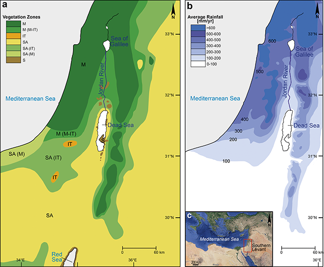
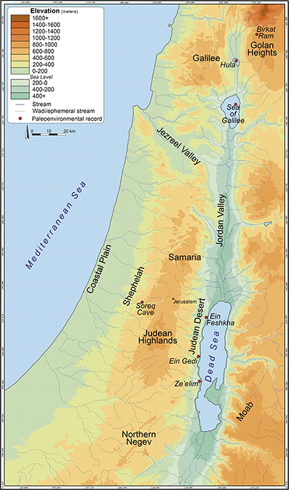
This relationship between climate and civilization is particularly evident in the SL, a region at the crossroads of Asia, Europe, and Africa. Situated on the fringe of the Mediterranean climate zone and bordering the hyper-arid desert, the Levant’s hydro-climatic conditions have historically been highly sensitive to even minor global climate perturbations (Figure 1; Rosen Reference Rosen2007). Moreover, the region has witnessed some of the most dramatic episodes of human development. During prehistoric times, the Levantine Corridor served as a primary route for hominin migration out of Africa (Grove Reference Grove2015) and contains some of the earliest evidence for the transition to agriculture (Zohary et al. Reference Zohary, Hopf and Weiss2012). In historical periods, the region experienced significant societal transformations, including the rise and fall of urban societies during the Bronze Age, the emergence of the territorial kingdoms in the early Iron Age, and the dominance of imperial powers from the later Iron Age through the following historical periods. These shifts are reflected in the archaeological record as periods of economic prosperity, decline, destruction, and sharp settlement oscillations, which include human movements between Mediterranean, semiarid, and desert environments (Finkelstein Reference Finkelstein and Levy1995; Rosen Reference Rosen2007). These settlement fluctuations may have been influenced by climatic shifts – such as prolonged droughts – but they could also reflect broader sociopolitical and economic changes, including shifts in subsistence strategies, warfare, environmental disasters (earthquakes, plagues), and political struggles (Greener et al. Reference Greener, Finkelstein and Langgut2018; Cline Reference Cline2021). Given the scarcity of textual evidence, scholars continue to debate the primary drivers behind these transformations – whether they were predominantly environmental or historical (Rosen Reference Rosen2007: 8–14; Rambeau Reference Rambeau2010), or some combination of both.
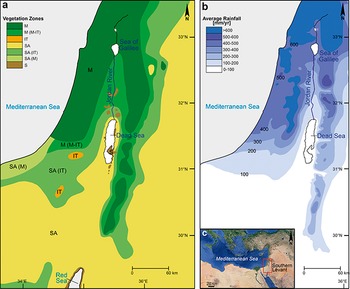
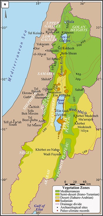
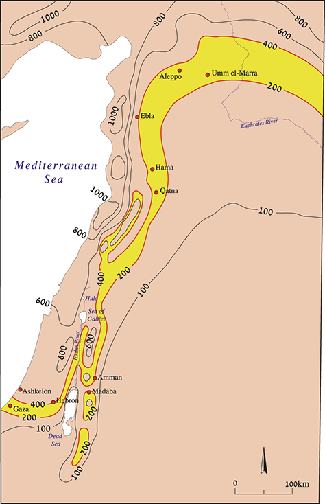
Distribution of phytogeograpic zones in the SL (after Zohary Reference Zohary1973, Reference Zohary1982 and Danin Reference Danin2004); M = Mediterranean zone (garrigue, maquis, woodland); IT = Irano-Turanian zone (steppeland); SA = Saharo-Arabian zone (desert); S = Sudanian zone (penetration territory); b. Map of the SL indicating mean annual precipitation in millimeters (Srebro and Soffer Reference Srebro and Soffer2011); c. The location of the SL.
This Element presents a regional paleoclimateFootnote 1 history of the SL, which is primarily based on pollenFootnote 2 records from the region, a powerful tool for understanding past vegetation, climate history, and human–environment interactions (Bryant Reference Bryant and Calhoun1989; Faegri and Iversen Reference Faegri and Iversen1989). Other paleoclimate proxies, such as reconstructions of Dead Sea Lake levels and isotopic recordsFootnote 3 from Soreq Cave, are also examined. Additionally, the Element explores the region’s natural landscape, incorporating newly established databases on wood-charcoal remains from SL mounds, as well as the local palynological records. Beyond climate reconstruction, it evaluates changes in the natural environment, the magnitude and composition of fruit-tree horticulture, and human-induced landscape modifications such as deforestation, landscape terracing, and overgrazing.
Throughout the Element, a critical approach is taken in evaluating the role of climate and environment in shaping social and political processes. While climate is undoubtedly a key factor, it is only one among many influencing settlement patterns and subsistence strategies in the region during this period. The Element also considers the role of governing empires in crisis management and economic control, particularly examining Egypt’s administration of Canaan during the Late Bronze Age (LBA). Through this interdisciplinary approach, this Element seeks to provide a nuanced understanding of climate’s role, alongside other influencing factors, in shaping human societies in the ancient SL.
Although the primary focus is on the period between ca. 1300–300 BCE, this study takes a long-term perspective to better identify and contextualize climate changes over an extended timeframe – from the Early Bronze Age (EBA) through the Achaemenid period (recently reviewed by Langgut and Finkelstein Reference Langgut, Finkelstein, Koch, Lipschits and Sergi2023a). The dating of the archaeological periods in this Element follows, as far as possible, the radiocarbon results of Levantine archaeological sites from the last decade (Table 1). This broader approach allows for a more precise assessment of climate variability and its potential impacts.
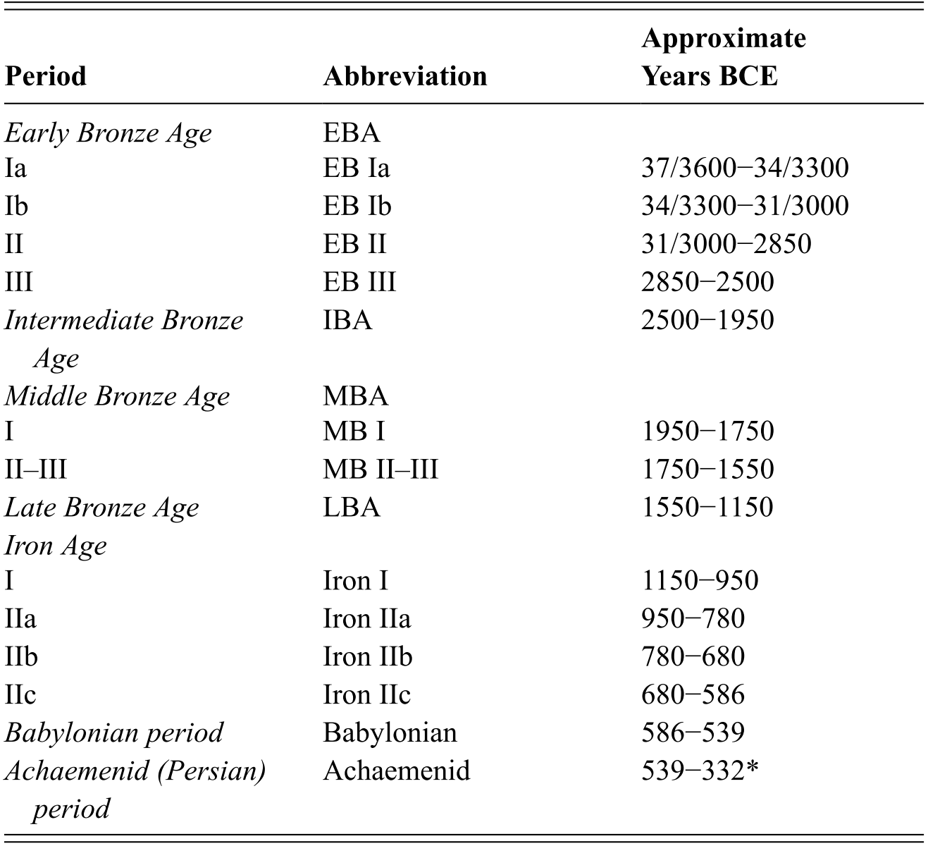
Table 1 Long description
The chronology of the periods used in this Element follows recent regional superscript 14 end superscript C dates. The table consists of three columns: period, abbreviation and approximate years BCE.
* The Persian period in the SL, also termed Achaemenid, is generally dated to 539 BCE, beginning with its conquest of the Babylonian Empire, and ending in 332 BCE with its defeat by Alexander the Great.
This first section serves as an introduction to the two subsequent sections, which discuss climate reconstruction (Section 2) and environmental reconstruction (Section 3) in detail for the period ca. 1300–300 BCE in the SL, with a continuous examination of the potential link between climate and environmental changes and human activity. Section 4 provides a brief summary of the synthesis presented in Sections 2 and 3.
1.2 Geographical Setting of the Southern Levant
The starting point for any climatic and environmental reconstruction is the present conditions within the study area. In the following sections, the current climate (1.2.1) and vegetation (1.2.2) prevailing in the SL will be presented.
1.2.1 Climate
The SL region is mainly influenced by rainfall that originates in the Northeast Atlantic Ocean, passing over Europe and the Mediterranean Sea. The Cyprus Low largely controls the winter rainfall temporal and spatial variability in the region (Ziv et al. Reference Ziv, Dayan, Kushnir, Roth and Enzel2006). During spring and autumn, synoptic systems from southern and southeastern origins may occur. The summers are hot, with almost no rainfall, due to the influence of the Persian Trough (Dayan et al. Reference Dayan, Ziv, Shoob and Enzel2007). The Negev Desert, occupying the southernmost part of the Levant, is part of the global desert belt along the 30°N latitude (Ziv et al. Reference Ziv, Dayan, Kushnir, Roth and Enzel2006).
The SL is characterized by two primary precipitation gradients. The first is a sharp north-to-south transition from a subhumid Mediterranean climate, which receives over 800 mm of mean annual precipitation, to the hyper-arid conditions of the southern Negev Desert, where annual rainfall drops below 50 mm (Figure 1b). The northern Sinai coastline marks the southernmost limit where rain clouds can form. This steep precipitation gradient occurs over a span of less than 300 km (Ziv et al. Reference Ziv, Dayan, Kushnir, Roth and Enzel2006; Dayan et al. Reference Dayan, Ziv, Shoob and Enzel2007; Srebro and Soffer Reference Srebro and Soffer2011). The second gradient extends west to east, from the Mediterranean coast toward the Dead Sea Rift Valley. This gradient is shaped by an orographic barrier – the central ridge – which creates a rain-shadow effect. The western slopes of the ridge experience a typical Mediterranean climate, whereas the eastern slopes transition rapidly into the arid conditions of the Judean Desert. This climatic shift occurs over a distance of less than 100 km (Figure 1b). The southern boundary of the Judean Desert directly borders the northeastern edge of the Negev Desert. Unlike the latter desert, which results from large-scale global air circulation patterns, the Judean Desert is a localized climatic phenomenon (a rain-shadow desert; Ziv et al. Reference Ziv, Dayan, Kushnir, Roth and Enzel2006). The dominant winds in the region originate from the north and northwest, playing a major role in transporting wind-borne pollen that becomes embedded in the sediments of the Dead Sea and the Sea of Galilee (hereafter Kinneret). During the spring and fall, easterly winds also occur, primarily associated with the Red Sea Troughs and Sharav Cyclones (Ziv et al. Reference Ziv, Dayan, Kushnir, Roth and Enzel2006).
To assess potential links between past climate conditions and economic-demographic processes, the most sensitive zone for climate–human interactions is the transitional belt between the Mediterranean and desert environments – the semiarid steppe zone, characterized by Irano-Turanian steppe vegetation (also referred to as dwarf shrublands; Figure 1a). This transitional area supports a combination of dry farming, primarily barley cultivation, and pastoral subsistence. Periods of increased precipitation allowed for an expansion of this zone southward and eastward, while drier conditions forced it to retract northward and westward (Finkelstein and Langgut Reference Finkelstein and Langgut2014). Settlements located near perennial water sources may have been able to endure longer periods of aridity, whereas those without consistent water access were more likely to be abandoned.
1.2.2 Vegetation
The SL is composed of three main phytogeographical zones: (1) the Mediterranean, (2) the Irano-Turanian, and (3) the Saharo-Arabian. The latter also includes some tropical plants which belong to the Sudanian vegetation (Figure 1a; Zohary Reference Zohary1973, Reference Zohary1982; Danin Reference Danin2004).
1. The Mediterranean region which runs along the coast and its adjacent mountainous areas (Galilee, Carmel Ridge, Samaria, and Judea). The hills feature Mediterranean maquis/forest with typical evergreen trees, mainly kermes oak (Quercus callipprinos), and pistachio (Pistacia palaestina), and, to a lesser extent, some olives (Olea europaea), Aleppo pines (Pinus halepensis), and some deciduous oaks (Quercus boissieri and Q. ithaburensis). In open fields or the understory of the maquis/forest, dwarf-shrubs such as Mediterranean buckthorn (Rhamnus lycioides) and sumac (Rhus coriaria) are present. Herbaceous species are also common (e.g., branched asphodel; Asphodelus microcarpus). This vegetation zone receives more than 400 mm of annual precipitation and is generally influenced by the Mediterranean climatic system together with some regional orographic phenomena. The Israeli coastal plain occupies a mix of Mediterranean and desert plants due to its sandy soil and saline environment. This sandy strip is dominated by different species of grasses (Poaceae), goosefoots (Chenopodiaceae), sand wormwood (Artemisia monosperma), and Mormon-tea (Ephedra spp.).
2. The Irano-Turanian phytogeographic zone lies from the coastal plain near Gaza to the Negev Highlands and the southern edge of the Judean Highlands and then continues northward via the Central Jordan Valley to the Kinneret. This is an almost treeless landscape with semiarid vegetation, often described as steppe or dwarf shrublands. Different species of grasses and chenopods are the main vegetal elements of this zone as well as white wormwood (Artemisia herba-alba). The annual rainfall is below 400 mm on average and is due mainly to Mediterranean depressions. The region is also typified by relatively broad seasonal and daily temperature distributions.
3. The Saharo-Arabian vegetation zone occupies most of the Negev and Judean Deserts, the Dead Sea region, the Arabah Valley, Sinai, and the southern and eastern portions of Transjordan. The vegetation is typified by relatively low species diversity and concentrated mostly in wadi beds. It is dominated by many members of the goosefoots and grasses, bushy bean-caper (Zygophyllum dumosum), white broom (Retama roetam), and tamarisk (Tamarix spp). This region has a typical desert climate: The mean annual rainfall does not exceed 200 mm and is usually lower than 100 mm. Seasonal and daily temperature distributions are broad. It is influenced by southern and southeastern synoptic systems, which are widespread in the spring and autumn, as well as by the western Mediterranean depressions, which mainly influence the northern part of the Negev Desert. Within these desert plants’ geographical area, Sudanian territory with tropical elements occurs along the shores of the Dead Sea, in the Arabah Valley, and the Central Jordan Valley (up to about 80 km north of the Dead Sea). Some of the tropical plants are linked to freshwater springs or wadi beds; they include Acacia, Jujube (Ziziphus spina-christi), and toothbrush tree (Salvadora persica; Al-Eisawi Reference Al-Eisawi1996; Danin Reference Danin2004).
1.3 Paleoclimatological and Paleoenvironmental Proxies
This section will describe the paleoclimatological and paleoenvironmental records that will be used in this Element. The emphasis in this synthesis is on records sampled at high resolution and for which a relatively reliable chronological framework is available.
1.3.1 Palynological Records
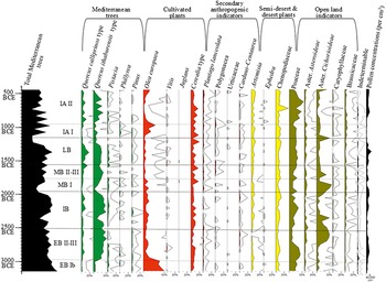
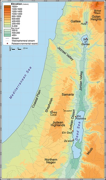
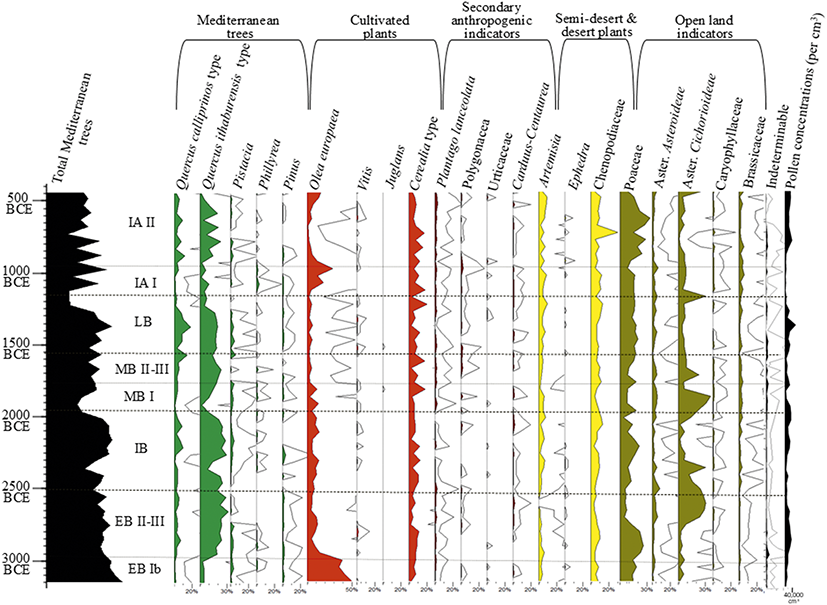
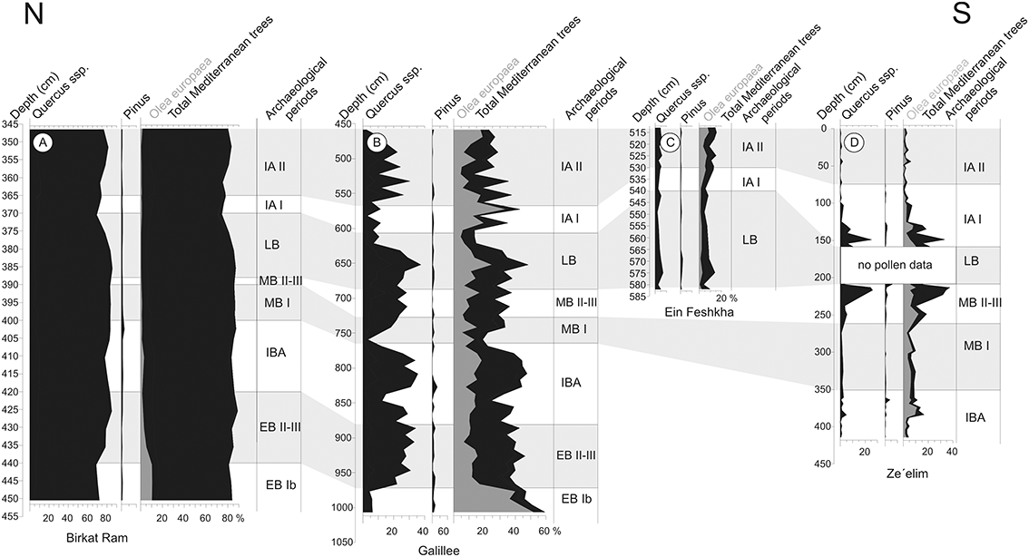
In this section, two palynological diagrams, produced by the author, will be presented in detail: the Kinneret and the Zeʾelim (Dead Sea; Figures 2 and 3).Footnote 4 The diagrams will be followed by a comparison of two other high-resolution, well-dated SL palynological records: Ein Feshkha (Neumann et al. Reference Neumann, Kagan, Schwab and Stein2007a) and Birkat Ram (Neumann et al. Reference Neumann, Schölzel, Litt, Hense and Stein2007b). The four sequences present a north–south transect of 220 km along the SL (Figures 4 and 5). Palynological records are used to reconstruct past climates, primarily based on changes in the percentages of elements from the Mediterranean woodland. High percentages of arboreal pollen (AP) indicate relatively high precipitation and the expansion of the Mediterranean woodland, and vice versa (Bryant Reference Bryant and Calhoun1989). Palynological records also help to reconstruct human activities such as agriculture (mainly Oleiculture, since the olive can disperse pollen over long distances compared to other cultivated species; Langgut et al. Reference Langgut, Lev-Yadun and Finkelstein2014b), afforestation, and overgrazing (mainly indicated by an increase in pollen from plants not eaten by herds; Langgut et al. Reference Langgut, Neumann and Stein2014a).
Concise pollen diagram of the Kinneret.
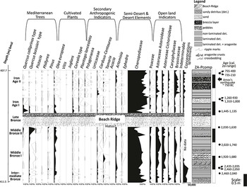
Concise pollen diagram of the Dead Sea.
A topographic map with locations of the paleoclimatological records.
A north–south transect of 220 km along the SL during the Bronze and Iron Ages, composed of the pollen records from Birkat Ram (A), Kinneret (Galilee; B), and the Zeʾelim Gully (D). Four main pollen curves are given: Quercus (oak), Pinus halepensis (pine), Olea europaea (olive), and total tree pollen of the Mediterranean maquis/forest.
The Kinneret
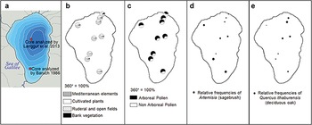
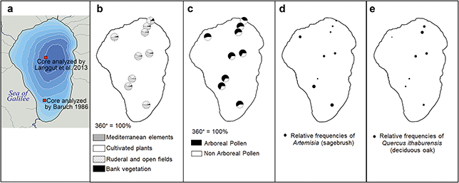
In 2010, an 18 m core was extracted from the northern inner part of the lake (Figure 6a), capturing nearly the entire HoloceneFootnote 5 sequence. A 5.5-m section, representing the EB Ib to the end of the Iron Age (composite depth: 458.8–1006.6 cm), was analyzed at forty-year intervals between pollen samples (Langgut et al. Reference Langgut, Finkelstein, Litt, Neumann and Stein2015). Other portions of the profile were examined at a lower resolution, with ca. 120 years between samples (Schiebel Reference Schiebel2013: 26 and Appendix 6). Within the core, sediments composed of fine gray-to-black silts and clays with little carbonate offer excellent preservation of pollen. The chronological framework for the Kinneret record is based on nine radiocarbon dates of short-lived organic material (Langgut et al. Reference Langgut, Adams and Finkelstein2016: table 1). The core has a relatively uniform lithology, showing no depositional hiatus, thereby indicating a continuous sedimentary record, which is further supported by consistent pollen concentration values (Langgut et al. Reference Langgut, Finkelstein and Litt2013a). To assess the sources of pollen in the lake and potential variations in pollen distribution based on sampling location (e.g., inner lake vs. shoreline), nine more pollen samples were collected from the uppermost layer of the lake-bottom sediments. Analysis of these recent samples indicates that the considerable size of the Kinneret (approximately 170 sq. km) and the extraction of the core from the center of the lake minimize the influence of shoreline vegetation on the pollen spectrum, providing a reliable representation of regional environmental conditions (Figure 6b). The uniformity of the arboreal pollen/non-arboreal pollen ratios in recent assemblages (Figure 6c) is also a very good indication of the reliability of the fossil data in the core. The recent data also show that the southern area around the lake contributes more semiarid steppe vegetation (e.g., Artemisia, Figure 6d), while the northern parts of the lake reveal Mediterranean elements (e.g., the deciduous oak – Quercus ithaburensis pollen type, Figure 6e).
Kinneret bathymetric map with the location of the palynological cores; (b-e). Recent pollen investigation.
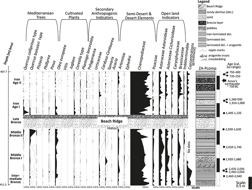
The Zeʾelim (Dead Sea)
The Zeʾelim Gully is situated east of the Masada Plain and is part of the Zeʾelim Ravine, which drains the southern Judean Desert (Figure 4). This ravine transports water and sediments originating from the eastern slopes of the Judean Highlands. At present, water flows through the wadi only a few days per year, primarily during the winter months. Throughout the Holocene, the Dead Sea’s water level has fluctuated between 370 and 430 m below mean sea level (MSL; Frumkin and Elitzur Reference Frumkin and Elitzur2002; Enzel et al. Reference Enzel, Bookman and Sharon2003; Bookman [Ken-Tor] et al. Reference Bookman (Ken-Tor), Enzel, Agnon and Stein2004; Migowski et al. Reference Migowski, Stein, Prasad, Negendank and Agnon2006). Currently, the lake stands at 438 m below MSL due to extensive water extraction for irrigation and drinking, as well as the maintenance of evaporation ponds in the southern Dead Sea basin – processes that have intensified over the past four decades. This ongoing anthropogenic decline in water levels (>100 cm/year) has led to the formation of deep gullies along the lake’s shore terraces, exposing the Holocene Zeʾelim Formation (Figure 7).
The Zeʾelim sedimentological outcrop that was used to conduct palynological and sedimentological investigations, with main archaeological periods and elevations (presented in meters below mean sea level); b. Zeʾelim gullies incising into the receding shores of the Dead Sea (Google Earth). The arrow marks our sampling location. c. Sediments’ depositional environments.
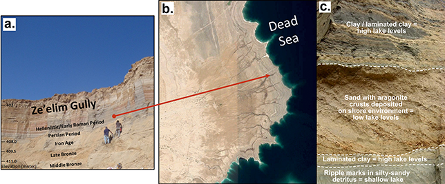
The sediment outcrop extracted from the Zeʾelim Gully for palynological investigation consists of several 50-cm-long sediment wall profiles. Pollen samples were collected at ca. 5 cm intervals, each representing a time span of three to four decades (Langgut et al. Reference Langgut, Neumann and Stein2014a). This outcrop is located near a previously studied section by Neumann et al. (Reference Neumann, Kagan, Schwab and Stein2007a), who analyzed the pollen record at a lower and more irregular resolution. The proximity of the two profiles enabled stratigraphic and chronological correlation (Langgut et al. Reference Langgut, Neumann and Stein2014a; Kagan et al. Reference Kagan, Langgut, Boaretto, Neumann and Stein2015). The chronology of the integrated sediment sequence is based on 11 14C dates obtained from short-lived organic material (Langgut et al. Reference Langgut, Neumann and Stein2014a; Kagan et al. Reference Kagan, Langgut, Boaretto, Neumann and Stein2015). A seismic event dated to the 8th century BCE provided a key chronological anchor (Kagan et al. Reference Kagan, Stein, Agnon and Neumann2011). The compiled Zeʾelim profile spans ca. 2500–500 BCE, covering the period from the IBA to the end of the Iron Age. The study of the sediments’ depositional environment enabled the reconstruction of the lake levels at this time interval (Kagan et al. Reference Kagan, Langgut, Boaretto, Neumann and Stein2015; will be further discussed in the next section).
The Ein Feshkha
A 5.85-m-long sediment outcrop was sampled from the gully wall at the Ein Feshkha National Reserve (Neumann et al. Reference Neumann, Kagan, Schwab and Stein2007a). This site, located on the northwest side of the Dead Sea (Figure 4), is influenced by water and sediment flow from the central Judean Hills. The profile consists mainly of fine detrital particles and sequences of laminated couplets of aragonite and silty detritus, or triplets composed of detritus, aragonite, and gypsum (all embedded in a lake environment; Neumann et al. Reference Neumann, Kagan, Schwab and Stein2007a). The chronological framework of the section is based on ¹⁴C dating (Neumann et al. Reference Neumann, Kagan, Schwab and Stein2007a) and by integrating historical earthquake events. The record begins around 1400 BCE, during the middle of the LBA, and was sampled for pollen analysis at a resolution of 10 cm or less, corresponding to ca. thirty years between samples.
The Birkat Ram
Birkat Ram, in the foothills of Mount Hermon (Figure 4), comprises a small lake that has occupied this volcanic depression since the last interglacial period (Singer and Ehrlich Reference Singer and Ehrlich1978). In 1999, a joint team of GFZ-Potsdam and the Hebrew University of Jerusalem extracted several cores that were used to prepare a 543-cm-long composite profile. Correlations between the cores were established by high-resolution magnetic susceptibility, which was independently improved by palynological observations (Neumann et al. Reference Neumann, Schölzel, Litt, Hense and Stein2007b). The compiled sedimentary record is characterized by a relatively homogenous lithology of detrital marls. Eighteen samples were 14C dated and a chronological framework was established from ca. 4500 BCE to modern times (Neumann et al. Reference Neumann, Schölzel, Litt, Hense and Stein2007b). The palynological investigation was conducted at an average sample interval of ca. 4 cm from the Bronze to the Iron Ages. Considering a uniform sedimentation rate in the composite core, this would imply that every sample represents, on average, seventy-five years.
1.3.2 Sedimentology, Lake Level Reconstruction, Isotopic Records
To reconstruct the regional climate history, in addition to the pollen records, several well-dated, relatively high-resolution records were utilized, including sedimentological sequences, Dead Sea lake level reconstructions, the isotopic record from Soreq Cave, and other lower-resolution profiles. During the Holocene, the water level of the Dead Sea varied between 370 and 430 m below mean sea level (Frumkin and Elitzur Reference Frumkin and Elitzur2002; Enzel et al. Reference Enzel, Bookman and Sharon2003; Bookman [Ken-Tor] et al. Reference Bookman (Ken-Tor), Enzel, Agnon and Stein2004; Migowski et al. Reference Migowski, Stein, Prasad, Negendank and Agnon2006). From 1870 to 1964 – just before human intervention in the Jordan River’s flow – a positive correlation existed between precipitation and recorded Dead Sea levels (Enzel et al. Reference Enzel, Bookman and Sharon2003). The lake rose when annual precipitation in Jerusalem exceeded ca. 650 ± 100 mm and receded when it dropped to around 450 ± 100 mm (Enzel et al. Reference Enzel, Bookman and Sharon2003). The most significant rise in Dead Sea levels since human intervention in the regional water balance occurred during the winter of 1991/92, when exceptionally high rainfall was recorded across the watershed (ca. 1500 mm in Jerusalem, compared to an annual mean of 550 mm). That winter, the Degania Dam, which regulates the outflow of the Jordan River from the Kinneret, was opened, causing the Dead Sea level to rise by more than 1.5 m.
In this study, only the sedimentology of the Dead Sea Zeʾelim record was used to reconstruct the sediments’ depositional environment (Figure 7): shoreline, shallow lake, and deep lake. The other pollen records do not feature dramatic changes in their sedimentology. At the Zeʾelim record, the identification of beach ridges, sands, small pebbles, and aragonite crusts represents the existence of ancient shorelines and relatively low lake levels. At the same time, the presence of ripple marks and silty-sandy detritus indicates very shallow near-shore depths, while laminated detritus and laminated aragonite and detritus indicate a few meters or more water depth. Breccia layers indicate seismic events. The sedimentological composition observations for the Zeʾelim profile are shown in the right column of the Zeʾelim pollen diagram (Figure 3).
Other sedimentological investigations reviewed here include geoarchaeological studies conducted near tells Lachish (Rosen Reference Rosen1986), Erani (Rosen Reference Rosen1991), and Megiddo (Rosen Reference Rosen, Finkelstein, Ussishkin and Halpern2006), all located at the Mediterranean vegetation zone with rainfalls originate mostly from the Mediterranean Sea (Cyprus cyclones). These paleogeomorphological studies are more localized in scope compared to the Zeʾelim sedimentological study, which represent the climatology and hydrology of a larger area, that is, the Dead Sea drainage basin.
Isotopic records of oxygen (δ¹⁸O) and carbon (δ¹³C) in speleothems (=cave deposits) serve as highly reliable paleoclimate indicators. For the Eastern Mediterranean, the most comprehensive such record currently available is from Soreq Cave (Bar-Matthews et al. Reference Bar-Matthews, Keinan and Ayalon2019 and references therein). This record is distinguished by its continuity (varied but continuous growth for 250,000 years), high sampling resolution, well-established chronological framework (based on Uranium-Thorium dating), and advanced modeling techniques that translate isotopic data into climatic parameters. The cave is located ca. 30 km west of Jerusalem and about 35 km inland from the Mediterranean Sea (Figure 4). It is part of a series of karstic formations on the westward-facing slope of the Judean Mountains anticline. The region’s climate and vegetation are characteristic of the Mediterranean zone, with most rainfall occurring in autumn and winter, averaging around 520 mm annually (Bar-Matthews and Ayalon Reference Bar-Matthews and Ayalon2011; Srebro and Soffer Reference Srebro and Soffer2011). The majority of storm systems originate from the Mediterranean Sea (primarily Cyprus cyclones), though some derive from the Red Sea region (Ziv et al. Reference Ziv, Dayan, Kushnir, Roth and Enzel2006). Consequently, isotopic data from the cave primarily reflect climatic conditions influenced by Mediterranean fronts. Here, stable oxygen (δ¹⁸O) and carbon (δ¹³C) isotope variations in the speleothem laminae provide insights into average rainfall amounts and vegetation responses to precipitation fluctuations during the mid to late Holocene (Bar-Matthews and Ayalon Reference Bar-Matthews and Ayalon2011; Bar-Matthews et al. Reference Bar-Matthews, Keinan and Ayalon2019).
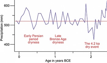
This study utilizes the high-resolution mid-Holocene (ca. 5000–2000 BCE) Soreq Cave profile analyzed by Bar-Matthews and Ayalon (Reference Bar-Matthews and Ayalon2011) and a stalagmite section (2–33) analyzed by Laugomer (Reference Laugomer2017), covering the period of ca. 2500–0 BCE. Currently, this isotopic profile offers the highest sampling resolution available to date for that period, with an average interval of ca. 65 years between samples (Laugomer Reference Laugomer2017). To assess speleothem growth rates, petrographic thin sections were analyzed. The results of this study (Laugomer Reference Laugomer2017) are presented here as an average rainfall graph, derived from the modeled isotopic measurements of stalagmite 2–33 (Figure 8).
Soreq Cave average rainfall graph.
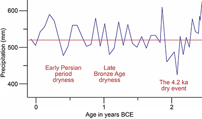
Figure 8 Long description
The x-axis represents the age in years, ranging from 0 to 2, while the y-axis represents the precipitation in millimeters, ranging from 400 to 600. A best-fit line is drawn parallel to the x-axis at 520 m m. The actual line starts at 520 and ends beyond 600, with dramatic fluctuations throughout. Three points of note are a dip to about 470 in the Early Persian dryness period, a dip to about 480 in the Late Bronze Age dryness, and a severe dip to about 430 in the 4.2 k a dry event.
1.3.3 Charred Wood Remains
The majority of the wood remains at SL sites are charred, representing fuel remains (Langgut and Lev-Yadun Reference Langgut, Lev-Yadun, Nikita and Rehren2024).Footnote 6 This type of remains is most often used to reconstruct the site’s immediate environment – both the natural arboreal landscape and the anthropogenic landscape, such as orchards.Footnote 7 In anthracological studies, it is generally assumed that wood used for daily activities such as construction, fuel, and tool-making was sourced from the immediate surroundings of a site (e.g., Asouti Reference Asouti2025). According to the principle of least effort (Shackleton and Prins Reference Shackleton and Prins1992), the wood available in the area would have been the easiest to access. These assemblages are less effective for climate reconstruction, as they are less sensitive than other proxies commonly employed for this purpose, such as pollen and isotopes (Langgut and Lev-Yadun Reference Langgut, Lev-Yadun, Nikita and Rehren2024).
Several wood assemblages of statistically reliable size have been analyzed from SL sites spanning the period of ca. 1300–300 BCE within the Mediterranean vegetation zone (Liphschitz Reference Liphschitz2007 and references therein; Benzaquen et al. Reference Benzaquen, Finkelstein and Langgut2019; Jin et al. Reference Jin, Lipschitz and Langgut2024), and only one is available for the Desert area (Cavanagh et al. Reference Cavanagh, Ben-Yosef and Langgut2022). Charred-wood assemblages reflect the nearby woody plant environment of the sites filtered through the inhabitants’ preferences, wood usage, economic considerations, and factors such as wood availability, ease of access, quality, and preservation (Langgut and Lev-Yadun Reference Langgut, Lev-Yadun, Nikita and Rehren2024; Asouti Reference Asouti2025).
2 Climate History
This section provides a detailed discussion of the SL paleoclimate and potential links between climatic fluctuations and changes in human lifeways, as reflected, among other things, in shifts in settlement patterns. Given that paleoclimate research is largely relative, the discussion begins with the periods preceding the focus interval of this Element, ca. 1300–300 BCE (Section 2.1; The EBI to the LBI). The climatic crisis at the end of the LBA is then examined using climatological, archaeological, and textual evidence, followed by an overview of human responses to the severe aridity (Section 2.2). Finally, the climate of the Iron Age and Achaemenid period is analyzed in detail along with changes in settlement patterns (Sections 2.3 and 2.4, respectively).
2.1 The EB I to the LBII
The palynological evidence, along with other paleoclimatological proxies, indicates that the EB I (ca. 3700/3600–3000 BCE) experienced the wettest climate conditions within the time span extending from the Bronze Age to the early Classical periods. According to Figure 5, two palynological diagrams are available for this period: Birkat Ram and the Kinneret (the latter beginning around 3150 BCE, corresponding to the later phase of the period). The Mediterranean arboreal pollen curves, including olive trees, reach their highest percentages, indicating that the EB I was characterized by high available moisture. Similarly, evidence of relatively wet climatic conditions is reflected in the Soreq Cave isotopic record (Bar-Matthews and Ayalon Reference Bar-Matthews and Ayalon2011: fig. 6) and the Jezreel Valley geoarchaeological data (Rosen Reference Rosen, Finkelstein, Ussishkin and Halpern2006). These wetter conditions may have facilitated the initial wave of settlement in the Negev Highlands (Langgut and Finkelstein Reference Langgut and Finkelstein2023b).Footnote 8 A similar pattern is observed in the semiarid regions of Transjordan, where there are more EB I sites than EB II–III sites (Philip Reference Philip and Adams2008: 189; Bradbury et al. Reference Bradbury, Braemer and Sala2014: 211–214).
During the EB II (ca. 3000–2900 BCE) wet climate conditions continued to prevail in the region. Only a slight reduction in arboreal vegetation was recorded, possibly indicating a minor shrinkage of the natural Mediterranean forest/maquis (Figure 5). The EB I/II transition around 3000 BCE marked a significant shift in social organization and settlement distribution in the SL. This shift appears to be unrelated to climate conditions but rather to territorial, political, or economic factors (Langgut et al. Reference Langgut, Adams and Finkelstein2016). The humid climate conditions characterizing the EB II are also reflected in the Soreq Cave isotopic record (Bar-Matthews and Ayalon Reference Bar-Matthews and Ayalon2011: fig. 6). The reconstruction of Dead Sea levels shows high stands during the period, with lake levels reaching 385 m below MSL (Migowski et al. Reference Migowski, Stein, Prasad, Negendank and Agnon2006: fig. 3), indicating wet climate conditions not only in the lake area but also in the northern parts of its drainage basin. Archaeobotanical remains from sites in the Mediterranean zone support evidence of a wet climate during the EB and its subperiods. For instance, seeds (Berger et al. Reference Berger, Longford, Greenberg and Fuller2025) and charred wood remains (Mor et al. Reference Mor, Greenberg and Langgut2025) from Beth Yerah, situated on the southwestern shore of the Kinneret, indicate humid climate conditions. Persistent wet conditions were particularly impactful on the marginal areas of the SL, especially in the south and east. During this period, the settlement activity in the Negev Highlands peaked (Cohen Reference Cohen1999), and the town of Arad in the Beer-sheba Valley reached its zenith, likely becoming a gateway community for southern trade (Finkelstein Reference Finkelstein1991; Finkelstein et al. Reference Finkelstein, Adams, Dunseth and Shahack-Gross2018).
Humid climate conditions continued throughout the EB III (ca. 2900–2500 BCE). Based on the Kinneret pollen record, this period is characterized by relatively high arboreal percentages. A minor increase in oak pollen documented in the Birkat Ram and Kinneret records suggests a slight expansion of the natural Mediterranean forest/maquis (Figures 2 and 5). The same picture emerged from a previous Kinneret palynological profile sampled at lower resolution (Figure 6a; Baruch Reference Baruch1986). The Soreq Cave isotopic record indicates humid climate conditions in the region, with estimated annual rainfall exceeding 520 mm for most of the period (the present-day mean annual rainfall above the cave; Bar-Matthews and Ayalon Reference Bar-Matthews and Ayalon2011), though a slight, gradual decline occurred over the course of this period.Footnote 9 The decrease in the number of sites in the central hill country and the southward expansion of urban settlement in the lowlands do not appear to be climate-related (Langgut et al. Reference Langgut, Adams and Finkelstein2016: table 2). New radiocarbon dates and other lines of evidence from the copper mining districts in the Arabah, the Negev Highlands, and Arad indicate human activity in the arid regions during the EB III, challenging previous theories (Ben Yosef et al. Reference Ben-Yosef, Gidding and Tauxe2016; Finkelstein et al. Reference Finkelstein, Adams, Dunseth and Shahack-Gross2018). While the wet climate conditions reconstructed for this period may have supported human activity in the arid lands of the SL, other factors seem to have been more influential, particularly the demand for copper in Egypt (Finkelstein et al. Reference Finkelstein, Adams, Dunseth and Shahack-Gross2018).

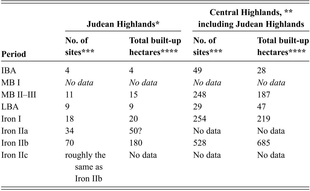
Table 2 Long description
The data tracks the change in the number of sites and total built-up areas within the region stretching from Jerusalem southward. These figures focus exclusively on habitation sites, excluding nomadic or pastoral groups, to provide a clear picture of sedentary life during the following periods: IBA, MB, LBA and Iron Age.
Remarks:
* Judean Highlands: from Jerusalem (included) to the south. Data are according to: Broshi and Finkelstein Reference Finkelstein1992; Finkelstein Reference Finkelstein1991, Reference Finkelstein1992, Reference Finkelstein and Levy1995; Finkelstein and Gophna Reference Finkelstein and Gophna1993; Ofer Reference Ofer, Finkelstein and Naʾaman1994).
** Central Highlands: between the Jezreel and the Beer-sheba Valleys.
*** Only habitation sites are included. Pastoral groups are not represented.
**** In order to reach a population estimate, built-up hectares should be multiplied by 200, a broadly accepted coefficient for persons per hectare in antiquity (e.g., Finkelstein Reference Finkelstein1990).
During the IBA (ca. 2500–1950 BCE), relatively wet climate conditions continued to exist in the region. At both Birkat Ram and the Kinneret, this period shows no significant change in the distribution of Mediterranean arboreal vegetation (Figure 5). This suggests that the crisis in the urban system, which began at the end of the EB III (ca. 2500 BCE) and continued throughout the IBA, was not driven by climate change. However, two brief events indicating drier conditions were recorded: one around 2350 BCE (based on the Kinneret record) and another at the end of the IBA/early MB I (Kinneret and Zeʾelim; Figures 2 and 5). These dry episodes were also reflected in the declining level of the Dead Sea (Kagan et al. Reference Kagan, Langgut, Boaretto, Neumann and Stein2015) and in the pollen record from Dan (Kaniewski et al. Reference Kaniewski, Marriner and Ilan2017). The IBA is marked by strong settlement activity in the Negev Highlands (Cohen Reference Cohen1999; Dunseth et al. Reference Dunseth, Junge and Lomax2017), associated with the copper industry in the Arabah Valley south of the Dead Sea (Ben-Yosef et al. Reference Ben-Yosef, Gidding and Tauxe2016; Finkelstein et al. Reference Finkelstein, Adams, Dunseth and Shahack-Gross2018). Although the humid climate conditions did not encourage dry farming in the region, they may have supported pastoral nomadic activity (Rosen Reference Rosen2017; Dunseth et al. Reference Dunseth, Junge and Lomax2017, Reference Dunseth, Finkelstein and Shahack-Gross2018; Langgut and Finkelstein Reference Langgut and Finkelstein2023b). The cessation of human activity in the region during the middle of the IBA (ca. 2300–2200 BCE) was likely linked to declining demand for copper due to the fall of the Old Kingdom in Egypt (Finkelstein et al. Reference Finkelstein, Adams, Dunseth and Shahack-Gross2018). More arid conditions at the end of the IBA are also evident in the lithology of the Zeʾelim section, which indicates sediment accumulation in a shore environment, with sands and a thin beach ridge deposited from ca. 2000 to 1800 BCE (Figure 3). Drier climate conditions were also documented in: (1) a previous Dead Sea palynological record sampled at a lower resolution (Litt et al. Reference Litt, Ohlwein, Neumann, Hense and Stein2012); (2) the declining level of the Dead Sea (dropping from 380 m below MSL to 400 m below MSL, with the decrease beginning slightly earlier, ca. 2200/2100 BCE, and lasting about 200–300 years) (Migowski et al. Reference Migowski, Stein, Prasad, Negendank and Agnon2006; Kagan et al. Reference Kagan, Langgut, Boaretto, Neumann and Stein2015); (3) the isotopic composition of tamarisk wood from the Mount Sedom Cave (southern Dead Sea), which suggests a prolonged drought of more than 100 years at the end of the IBA (Frumkin Reference Frumkin2009); and (4) the Soreq Cave speleothems isotopic record, which indicates a decline in precipitation between ~2200 and 1900 BCE (Bar-Matthews and Ayalon Reference Bar-Matthews and Ayalon2011; Laugomer Reference Laugomer2017). For most of the period, the estimated annual rainfall was below 520 mm (the present-day mean annual rainfall above the cave; Figure 8). Riehl et al. (Reference Riehl, Deckers, Hinojosa-Baliño, Gröcke and Lawrence2025) recently suggested that, during this dryness, rain-fed agricultural Levantine crops were supplemented with irrigation. The magnitude and duration of this event, as observed across multiple records, appear relatively consistent, suggesting a regional rather than localized phenomenon. Indeed, this dry episode has also been identified in isotopic records located north and east of the SL (Riehl Reference Riehl2009; Finné et al. Reference Finné, Holmgren and Shen2017; Sinmez et al. Reference Sinmez, Pişkin and Akar2025).
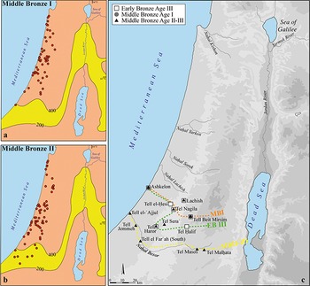
The MB I period (ca. 1950–1750 BCE) was marked by low humidity from its onset until ca. 1800 BCE. The pollen percentages of the Mediterranean trees remain relatively low (Figure 5), suggesting that the dry conditions that began at the end of the IBA persisted for about two centuries (ca. 2000–1800 BCE). Based on other paleoclimate records mentioned earlier, this event may have lasted slightly longer – about 200–300 years, between 2200 and 1800 BCE (Figure 8; Langgut et al. Reference Langgut, Finkelstein, Litt, Neumann and Stein2015; Laugomer Reference Laugomer2017). Can this dry event be linked to the widely debated 4.2 BP event, proposed by Weiss et al. (Reference Weiss, Courth and Wetterstrom1993) and Weiss (Reference Weiss and Weiss2012, Reference Weiss2017) as a region-wide “mega-drought” (see critique in, e.g., Wanner et al. Reference Wanner, Beer and Buetikofer2008; Finné et al. Reference Finné, Holmgren, Sundqvist, Weiberg and Lindblom2011)? The answer is that climatic proxies from the SL cannot be easily extrapolated to Mesopotamia, as the latter is influenced by additional climatic factors beyond the Mediterranean system (Finkelstein and Langgut Reference Finkelstein and Langgut2014 and references therein). The ca. 2000–1800 BCE dry phase may help explain shifts in settlement patterns across the Levant and beyond, from the Beer-sheba Valley in the south (Figure 9) to the upper Euphrates in the north. These changes include the withdrawal of permanent settlement from semiarid zones in southern Canaan and a demographic decline in steppe regions such as the Beqʿa Valley of Lebanon and the Jezirah. This was likely a consequence of the northward and westward shift of the 400 mm rainfall isohyet,Footnote 10 which marks the boundary between Mediterranean and Irano-Turanian steppe vegetation zones (Figure 9a). As a result, significant numbers of people may have migrated to more fertile parts of the Levant (see Burke Reference Burke2021: 72–85). This period of aridity in the Levant could also have contributed to the beginning of Asiatic settlement in the northeastern Nile Delta in the 19th century BCE (Bader Reference Bader2013; Bietak Reference Bietak2018; Höflmayer and Manning Reference Höflmayer and Manning2022).
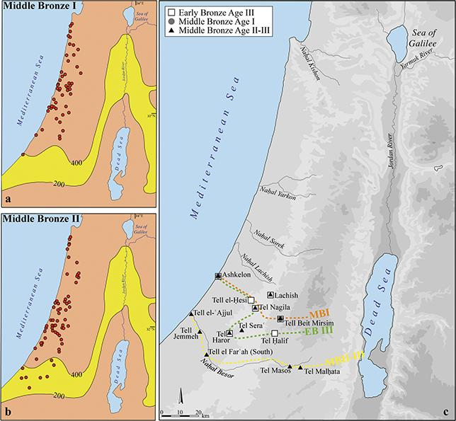
During the MB II–III (ca. 1750–1550 BCE) wetter climate conditions prevailed in the region, based on the three available pollen records for this period – Birkat Ram, Kinneret, and Zeʾelim (Figure 5), characterized by increasing percentages of Mediterranean trees (since ca. 1800 BCE). During this time, Zeʾelim sediments accumulated in a lake environment, signaling rising Dead Sea levels and more humid conditions, in contrast to the beginning of MB I when sediments were deposited in a shore environment (Figure 3). The reconstruction of Dead Sea levels suggests that during the MB II–III, the lake reached its highest stands in the past four millennia, rising to ca. 370 m below MSL (Migowski et al. Reference Migowski, Stein, Prasad, Negendank and Agnon2006; Kushnir and Stein Reference Kushnir and Stein2010).Footnote 11 Archaeological evidence points to increased settlement activity in the Central Highlands during the MB II–III (Table 2; Ofer Reference Ofer, Finkelstein and Naʾaman1994; Finkelstein Reference Finkelstein and Levy1995). Along the coast, the wetter climate conditions that followed the earlier dry phase appear to have facilitated the recovery and southward re-expansion of settlement systems into the Nahal Besor area and the Beer-sheba Valley (Figure 9b–c; Gophna and Portugali Reference Gophna and Portugali1988; Finkelstein et al. Reference Finkelstein, Adams, Dunseth and Shahack-Gross2018). In the Nile Delta, Asiatic settlement continued and intensified, this time primarily driven by economic factors (Bader Reference Bader2013; Bietak Reference Bietak2018).
Present vegetation cover and precipitation isohyets (after Zohary Reference Zohary1982 and Srebro and Soffer Reference Srebro and Soffer2011, respectively) of settlements in the southern coastal plain (after Gophna and Portugali Reference Gophna and Portugali1988), with the location of the semiarid (steppe) environment in the: a. MB I; b. MB II–III. c. Southern line of urban centers during the EB III, MB I, and MB II–III.
The early phase of the LBA was characterized by relatively wet climate conditions. According to pollen data from the northern sites (Birkat Ram and Kinneret; Figure 5), Mediterranean arboreal pollen percentages remained relatively high at the beginning of the period, indicating the continued presence of a well-developed Mediterranean forest/maquis. The Ein Feshkha record, which begins at ca. 1400 BCE, also shows high arboreal pollen values, though these declined toward the end of the period, reflecting a shift toward drier climate conditions (Figure 5). No pollen data from the LBA is available from the Zeʾelim record due to sedimentary erosion and poor conditions for pollen preservation in sandy sediments (Figures 3 and 7c). However, around the 14th century BCE (ca. 1350 BCE), high frequencies of Mediterranean tree pollen were recorded in the Kinneret pollen diagram, suggesting relatively wet climate conditions (Figures 2 and 5). This aligns with historical records, as the Amarna letters (ca. 1360–1330/35 BCE; Cline Reference Cline2025) do not mention droughts or famine in the region.Footnote 12 During the LBA, settlement activity significantly declined across Judea (Table 2), Samaria, and the hill country of the Galilee (Bunimovitz Reference Bunimovitz1994; Ofer Reference Ofer, Finkelstein and Naʾaman1994; Finkelstein Reference Finkelstein and Levy1995). However, the relatively high percentages of arboreal pollen (Figure 5) and estimated annual precipitation remaining above modern levels for much of this period (Figure 8; Laugomer Reference Laugomer2017) suggest that human factors, rather than climate change, were the primary drivers of this settlement decline.
2.2 The End of the Late Bronze Age: The “Crisis Years”
The most notable climatic shift from the Bronze Age to the early Classical periods occurred at the end of the LBA, around the mid 13th century BCE, and lasted about 150 years (Figure 5). In the following sections, the LB climatic crisis is examined based on climatological, archaeological, and textual evidence (2.2.1), followed by a discussion of human responses to the resulting aridity in the north and the SL (2.2.2).
2.2.1 The Climatological, Archaeological, and Textual Evidence
The period is characterized by exceptionally low arboreal vegetation percentages – both Mediterranean and olive trees – at the Kinneret and Ein Feshkha records, whereas the less-sensitive Birkat Ram record exhibits only a slight decline in arboreal pollen. Pollen data from Ein Gedi (Litt et al. Reference Litt, Ohlwein, Neumann, Hense and Stein2012) and the Kinneret diagrams (Figure 2) indicate that the decline in Mediterranean vegetation began in the mid 13th century BCE. The severity of this arid phase is further evidenced by a significant drop in Dead Sea levels (Kagan et al. Reference Kagan, Langgut, Boaretto, Neumann and Stein2015). Around 1300 BCE, Litt et al. (Reference Litt, Ohlwein, Neumann, Hense and Stein2012) report the accumulation of a thick sand unit in the En Gedi core, while Neumann et al. (Reference Neumann, Kagan, Schwab and Stein2007a) identify a sedimentological unconformity in the Ein Feshkha record from the same period. Additionally, a thick beach ridge formed in a shore environment in the Zeʾelim Gully around 1300/1200 BCE (Figures 3 and 7c). The presence of these shore deposits along the western margin of the Dead Sea suggests a substantial drop in lake levels, likely driven by reduced precipitation, particularly in the northern sources of the Dead Sea drainage basin (Kagan et al. Reference Kagan, Langgut, Boaretto, Neumann and Stein2015). Indeed, at Soreq Cave, estimated annual precipitation toward the end of the LBA fell below modern levels (Figure 8; Laugomer Reference Laugomer2017).
This prolonged drought spanning the end of the LBA is also evident in other Eastern Mediterranean paleoclimatological records, including the northern coasts and Hittite (Kaniewski et al. Reference Kaniewski, Paulissen and Van Campo2010; Manning et al. Reference Manning, Kocik, Lorentzen and Sparks2023; Sinmez et al. Reference Sinmez, Pişkin and Akar2025), Cyprus (Kaniewski et al. Reference Kaniewski, Van Campo and Guiot2013), Anatolia (Bottema et al. Reference Bottema, Woldring and Aytuğ1993/1994; Woldring and Bottema Reference Woldring and Bottema2003; Litt et al. Reference Litt, Krastel and Sturm2009), Cappadocia (Roberts et al. Reference 84Roberts, Allcock and Barnett2019), the Peloponnese (Finné et al. Reference Finné, Holmgren and Shen2017), and the Nile Delta (Bernhardt et al. Reference Bernhardt, Horton and Stanly2012). These data suggest that LBA aridification affected not only the SL but a vast geographical area (Kaniewski et al. Reference Kaniewski, Guiot and Van Campo2015, Reference Kaniewski, Marriner and Bretschneider2019; Knapp and Manning Reference Knapp and Manning2016; Cline Reference Cline2021).
In 2013, two independent palynological research groups proposed that prolonged droughts toward the end of the LBA may have been the primary driver behind the collapse of complex societies in the Eastern Mediterranean (Kaniewski et al. Reference Kaniewski, Van Campo and Guiot2013; Langgut et al. Reference Langgut, Finkelstein and Litt2013a). Prior to these pollen studies, this period was commonly referred to in the literature as the “crisis years” (Carpenter Reference Carpenter1966; Weiss Reference Weiss1982; Neumann and Parpola Reference Neumann and Parpola1987; Alpert and Neumann Reference Alpert and Neumann1989; Ward and Joukowsky Reference Ward and Joukowsky1992; Issar Reference Issar, Issar and Brown1998). Various factors have been suggested to explain this dramatic collapse, including a “perfect storm” of catastrophic events such as earthquakes, disease, famine, and invasions (Cline Reference Cline2021).
Carpenter was the first to link the “crisis years” to a climate event, specifically in relation to the fall of the Mycenaean world (Reference Carpenter1966). Beginning in the 1960s, researchers analyzing tablets from Hattusha, Ugarit, Emar, and Aphek identified evidence of droughts and famine at the end of the LBA (Astour Reference Astour1965; Klengel Reference Klengel1974: 170‒174; Na’aman Reference Na’aman, Finkelstein and Na’aman1994: 243‒245; Zaccagnini Reference Zaccagnini1995; Singer Reference Singer, Watson and Wyatt1999: 715‒719, Reference Singer and Oren2000, Reference Singer2009: 99). These textual records, led scholars to propose that a climate crisis in the Eastern Mediterranean played a key role in the collapse of LBA societies (Bryson et al. Reference Bryson, Lamb and Donley1974; Weiss Reference Weiss1982; Neumann and Parpola Reference Neumann and Parpola1987; Alpert and Neumann Reference Alpert and Neumann1989; Kuniholm Reference Kuniholm1990: 653‒654; Issar Reference Issar, Issar and Brown1998; Singer Reference Singer, Watson and Wyatt1999: 715‒719, Reference Singer and Oren2000; Fagan Reference Fagan2004: 182‒186; Kirlis and Herles Reference Kirlis and Herles2007; Drake Reference Drake2012). However, the absence of high-resolution, well-dated paleoclimate records left this hypothesis unconfirmed. This period in the Eastern Mediterranean saw the collapse of the palatial system in the Aegean Basin, the fall of the Hittite Empire in Anatolia, and the decline of major trade hubs such as Ugarit on the Syrian coast. It also marked the downfall of Alashiya (Cyprus), a dominant force in maritime copper trade, and the weakening of Egypt, which included its withdrawal from its Canaanite province (Ward and Joukowsky Reference Ward and Joukowsky1992; Drews Reference Drews1993). In the SL, the most significant settlement fluctuations occurred during the transition from the LBA to Iron I. In the lowlands, many city-state centers and secondary towns were destroyed, marking the first major wave of destruction in the Levant. Some cities, such as Hazor in the north and Lachish in the south, were completely devastated and remained in decline for an extended period, while others, like Megiddo, suffered only partial destruction and recovered relatively quickly (Finkelstein Reference Finkelstein, Dever and Gitin2003; Ben-Tor and Zuckerman Reference Ben-Tor and Zuckerman2008; Martin et al. Reference Martin, Finkelstein and Piasetzky2020). In contrast, the hill country saw minimal settlement activity during the LBA, followed by an unprecedented surge in new settlements during Iron I (Table 2; Finkelstein Reference Finkelstein and Levy1995).
There is broad consensus on two key points regarding the “crisis years”: (1) events – spanning Greece, Anatolia, the Levant, and Egypt – were interconnected (Ward and Joukowsky Reference Ward and Joukowsky1992; Cline Reference Cline2021, Reference Cline2024), and (2) significant movement of populations by both sea and land occurred (Stager Reference Stager and Levy1995; Oren Reference Oren2000; Yasur-Landau Reference Yasur-Landau, Maran and Stockhammer2012, Reference Yasur-Landau2014; Ben-Dor Evian Reference Ben‐Dor Evian2017; Burke Reference Burke and Driessen2018; Killebrew Reference Killebrew and Driessen2018). This is most evident in the well-documented accounts of Ramesses III’s confrontation with the Sea Peoples and the dramatic letters from Ugarit describing seaborne raids on coastal settlements, both of which date to the early 12th century BCE (Yon Reference Yon, Ward and Joukowsky1992; Singer Reference Singer, Watson and Wyatt1999: 719‒723; Ben-Dor Evian Reference Ben-Dor Evian2016).
The earliest indications of unrest linked to the “crisis years” appear in the archaeological record with the destruction of Hazor, which occurred sometime in the mid to late 13th century BCE (Ben-Tor and Zuckerman Reference Ben-Tor and Zuckerman2008). Aphek was likely destroyed toward the end of the 13th century BCE (Gadot Reference Gadot, Gadot and Yadin2009: 583‒586), while Ugarit fell in the early 12th century BCE (Yon Reference Yon, Ward and Joukowsky1992; Singer Reference Singer, Watson and Wyatt1999: 704–733). Other sites were destroyed at later stages. Several SL sites, including Lachish and Beth-Shean, show evidence of continued occupation at least until the reign of Ramesses IV in the 1140s BCE (e.g., Ussishkin Reference Ussishkin and Ussishkin2004: 69‒70; Finkelstein Reference Finkelstein1996; Finkelstein and Adams Reference Finkelstein and Adams2025). Radiocarbon dates from Tel Yafo suggest the date of 1125 BCE as a terminus post quem for the end of Egyptian rule in Canaan (Burke et al. Reference Burke, Peilstöcker and Karoll2017). The discovery of a statue base of Ramesses VI at Megiddo suggests the city remained active into the 1130s BCE (Ussishkin Reference Ussishkin1995; Finkelstein Reference Finkelstein1996). However, stratigraphic, ceramic, and radiocarbon evidence from excavations at Megiddo indicates that its final destruction occurred even later, around 1100 BCE (Martin et al. Reference Martin, Finkelstein and Piasetzky2020; Finkelstein and Adams Reference Finkelstein and Adams2025). Thus, the sequence of destruction across the SL spans ca. 150 years, from the mid 13th century to around 1100 BCE – precisely aligning with the period of prolonged drought recorded in the Kinneret pollen data.
Could a prolonged period of dry years severely impact settlement systems in the SL? The answer is affirmative for marginal areas, such as the southern Judean Highlands (Table 2; Langgut et al. Reference Langgut, Neumann and Stein2014a). However, the situation is less clear when considering the more fertile regions of the SL, like the Galilee and the northern valleys (Figure 1). A telling example emerges from patterns of animal husbandry: a close examination of herd economy, as reflected in zooarchaeological assemblages from sites in permanently settled areas, reveals no significant shifts in subsistence strategies during the LB–Iron Age sequence (Sapir-Hen et al. Reference Sapir-Hen, Gadot and Finkelstein2014; Sapir-Hen Reference Sapir-Hen2025). In other words, while a 100 mm drop in annual precipitation south of Hebron could be devastating, the same reduction at Megiddo, located in a “greener” area, might not have the same effect.
Textual evidence from various regions of the ancient Near East – including Hatti, Ugarit, Emar, Aphek in Canaan, and Egypt – provides insights into climate and food supply conditions. The Amarna tablets, which document life in Canaan between ca. 1360 and 1330/35 BCE, do not mention drought or famine, suggesting that any climatic upheaval had not yet begun by the mid to late 14th century BCE (Cline Reference Cline2025 and references therein). The first indications of grain shortages appear in the mid 13th century BCE. A Hittite queen wrote to Ramesses II, stating, “I have no grain in my lands” (KUB 21.38; Singer Reference Singer, Watson and Wyatt1999: 715). Around 1230 BCE, a letter from Aphek, precisely dated based on historically known individuals (Singer Reference Singer1983), also describes an urgent need for grain in the north. By the late 13th century, Pharaoh Merneptah reported in the Great Karnak Inscription that he “caused grain to be taken in ships, to keep alive the land of Hatti” (Wainwright Reference Wainwright1960). Ugaritic letters from the late 13th and early 12th centuries BCE further highlight the severity of the crisis. The king of Hatti wrote to Ugarit (RS 20.212) about an essential grain shipment, calling it “a matter of death or life” (Singer Reference Singer, Watson and Wyatt1999: 716). Another letter from a prominent Hittite official referenced “famine in the midst of my lands,” while a letter from the Urtenu archive warned: “The gates of the house are sealed. Since there is famine in your house, we shall starve to death. A living soul of your country, you will no longer see” (RS 34.152; Singer Reference Singer and Oren2000: 24). Some recent studies also confirm the link between grain shortage and the fall of Ugarit (Cohen Reference Cohen, Machinist, Harris, Berman, Samet and Ayali-Darshan2021; Cohen and Torrecilla Reference Cohen and Torrecilla2023). In Egypt, the price of grain rose sharply in the mid 20th Dynasty (Černý Reference Černý1933), reaching its peak during the reign of Ramesses VII in the latter half of the 12th century BCE (Janssen Reference Janssen and J1975: 551‒552). Collectively, this textual evidence suggests a prolonged period of crisis related to droughts and famine, spanning from the mid 13th century to the late 12th century BCE.
2.2.2 Human response to the LB Climate Crisis
Drawing on past and contemporary evidence, Flohr et al. (Reference Flohr, Fleitmann, Matthews, Matthews and Black2016 and references therein) outline four possible responses of social groups to climatic stress: (1) the collapse of economic systems followed by the disintegration of social and political structures; (2) migration to more favorable environments; (3) the development of resilienceFootnote 13 through adaptive adjustments to new conditions; and (4) no significant response when climatic anomalies are insufficient to cause major disruption. While these categories offer a helpful framework, real-world responses were often more nuanced, frequently combining multiple strategies. Moreover, the limitations of monocausal explanations that directly link environmental change to social crises have long been acknowledged (Butzer Reference Butzer1982; Rosen Reference Rosen2007). Climate crisis is best understood as one contributing factor among a range of political, cultural, and economic dynamics. Thus, distinguishing between correlation and causation in the climate–society nexus remains essential. At the same time, human agency and resilience remain central, as the capacity to adapt and respond is intrinsic to social existence (Weiberg and Finné Reference Weiberg and Finné2018; Cline Reference Cline2024), a point illustrated in this section through the chain of events at the end of the LBA in the Eastern Mediterranean.
The climate crisis that occurred at the end of the LBA appears to have triggered a prolonged and complex process that ultimately led to the collapse of most complex societies across the region (Langgut et al. Reference Langgut, Finkelstein and Litt2013a; Kaniewski et al. Reference Kaniewski, Guiot and Van Campo2015; Knapp and Manning Reference Knapp and Manning2016; Cline Reference Cline2021, Reference Cline2024). The following sequence of processes is based on the previously discussed paleoclimatological, archaeological, and textual evidence. The synthesis in the following two sections is divided into the northern and southern Levant.Footnote 14
The Northern Levant
Along the northern edges of the Mycenaean world and the Hittite Empire, the LB dry phase may have coincided with cold spells due to its position between Mediterranean and continental climatic zones. Examining textual evidence from the period between 950 and 1070 CE, Ellenblum (Reference Ellenblum2012) demonstrated how years of drought and cold could devastate yields and trigger mass migrations, leading to widespread instability as displaced populations sought sustenance in more fertile areas. Recent studies on LB climate change suggest the same scenario: Increasing aridity led to reduced vegetation cover in the steppe regions, severely limiting grazing and herding opportunities (Manning et al. Reference Manning, Kocik, Lorentzen and Sparks2023; Sinmez et al. Reference Sinmez, Pişkin and Akar2025). Crop failures triggered famine, forcing displaced groups to migrate southward in search of food, causing widespread instability and destruction (Driessen Reference Driessen and Driessen2018). This, in turn, pushed other populations to move by both land and sea. For example, large groups migrated from Anatolia to the southeast during the reign of Tiglath-pileser I (1114–1076 BCE; Na’aman Reference Na’aman, Finkelstein and Na’aman1994: 235–237). Nowicki (Reference Nowicki and Driessen2018) describes refugee settlements on Crete, and Vokotopoulos and Michalopoulou (Reference Vokotopoulos, Michalopoulou and Driessen2018) suggested the presence of displacement groups in the Aegean. Egyptian records date Ugarit’s destruction to the beginning of the 12th century BCE, linking it to regional drought and instability. Manning et al. (Reference Manning, Kocik, Lorentzen and Sparks2023) identified a dry phase at Hittite sites, also dated to the beginning of the 12th century BCE, coinciding with the Hittite collapse and likely overwhelming their mitigation systems. Texts from Hittite, Ugaritic, and Egyptian archives indicate the Hittites’ reliance on grain imports from Egypt and the SL amid famine, highlighting how climate-driven food shortages undermined regional stability (Astour Reference Astour1965; Klengel Reference Klengel1974: 170‒174; Singer Reference Singer, Watson and Wyatt1999: 715‒719, Reference Singer and Oren2000, Reference Singer2009: 99).
The resulting turmoil disrupted both overland and maritime trade, ultimately collapsing the interconnected economic network of the LBA. This is best exemplified by the Uluburun shipwreck, which dates to ca. 1300 BCE and reflects the prosperity of international connections in the Eastern Mediterranean, a moment before the beginning of the “crisis years.” The ship carried a diverse cargo indicative of an integrated trade system (Pulak Reference Pulak1998; Bachhuber Reference Bachhuber2006; Cline and Yasur-Landau Reference Cline and Yasur-Landau2007; Lankton et al. Reference Lankton, Pulak and Gratuze2022). As the economic framework unraveled, piracy became widespread, as recorded in several Ugaritic tablets (Yon Reference Yon, Ward and Joukowsky1992; Singer Reference Singer, Watson and Wyatt1999: 719–723). By the early 12th century BCE, groups identified in Egyptian texts as the “peoples of the sea” are said to have launched attacks on cities by land and sea, seeking provisions (O’Connor Reference O’Connor and Oren2000; Killebrew and Lehmann Reference Killebrew, Lehmann, Killebrew and Lehmann2013; Yasur-Landau Reference Yasur-Landau2014; Hitchcock and Maeir Reference Hitchcock and Maeir2016). The Sea Peoples likely migrated after the collapse had begun, making their movement a result rather than a cause of the crisis (Kaniewski et al. Reference Kaniewski, Guiot and Van Campo2015; Cline Reference Cline2024). The breakdown of Egypt’s Eastern Mediterranean trade networks, at least partially controlled by the pharaohs, led to Egypt’s withdrawal from Canaan, further destabilizing the region (Ben-Dor Evian Reference Ben-Dor Evian2016; Cline Reference Cline2021). Yet, sociopolitical complexity and population density were key factors shaping the societies’ resilience to LB climate stress; thus, socio-political decline cannot be explained by climate alone, as shown in the Peloponnese, for example (Weiberg and Finné Reference Weiberg and Finné2018).
The Southern Levant
In the more fertile regions of the Levant, the climate crisis was less severe, but the resulting economic and political turmoil from the north had significant consequences. It is plausible that marginal groups (displaced groups and/or seminomadic groups such as the ʿApiru)Footnote 15 exploited the regional instability to engage in raids and looting. Even relatively small bands, numbering only a few hundred or fewer warriors, could have attacked cities, undermined urban centers, and contributed to their economic and demographic decline. Thus, widespread urban destruction did not necessarily require large, organized armies (like the Sea Peoples) but could have resulted from opportunistic raiding.
Egyptian rule in Canaan spanned over three centuries during the LBA, from Thutmose III’s conquest to its eventual withdrawal, likely during the reign of Ramesses VI (Burke et al. Reference Burke, Peilstöcker and Karoll2017; Millek Reference Millek2018; Faust Reference Faust, Mohr and Thompson2023). The main urban centers in Canaan’s lowlands exhibit clear signs of devastation during the end of the Bronze Age, but the countryside presents a more complex picture. Arie (Reference Arie2011) has identified evidence of destruction in some rural settlements in the northern valleys, while other villages show signs of continuity from the LBA into Iron I (Finkelstein Reference Finkelstein, Dever and Gitin2003). Regional surveys further support this pattern, revealing settlement continuity in the western Jezreel Valley (Finkelstein et al. Reference Finkelstein, Halpern, Lehmann, Niemann, Finkelstein, Ussishkin and Halpern2006), the upper Jordan Valley (Ilan Reference Ilan1999), and the Jordan Valley south of the Kinneret (Maeir Reference Maeir1997). This suggests a dichotomy: While major urban centers were abandoned or destroyed, many rural settlements persisted, possibly absorbing displaced urban populations (Burke Reference Burke and Driessen2018; Killebrew Reference Killebrew and Driessen2018). Millek (Reference Millek2023) shifts the emphasis from a single system-wide collapse model for the SL to a mosaic of different local outcomes and processes. At Megiddo, for example, subtle variations in LBA pottery assemblages suggest that parts of the city were abandoned before its final destruction, indicating a gradual decrease rather than a sudden collapse (Martin et al. Reference Martin, Finkelstein and Piasetzky2020; Martin and Finkelstein Reference Martin and Finkelstein2025). Evidence suggests that settlement expansion in the highlands began as early as the late 13th century BCE, preceding the final wave of urban collapse in the late 12th century BCE (Finkelstein Reference Finkelstein1988: 315–321). Burke (Reference Burke and Driessen2018) contends that the withdrawal of Egyptian control from Canaan in the late 12th century BCE initiated a period of unrestricted movement within the Canaanite heartland, leading to the formation of Iron I highland settlements populated by displaced groups from nearby communities.
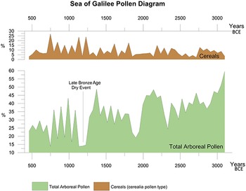
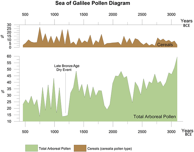
Various forms of evidence point to a regional adaptation to climatic stress. Riehl et al. (Reference Riehl, Deckers, Hinojosa-Baliño, Gröcke and Lawrence2025) recently proposed that, at the end of the LBA, irrigation was used to supplement rain-fed cultivation of Levantine crops. Finkelstein et al. (Reference Finkelstein, Langgut, Meiri and Sapir-Hen2017) identified indicators of an expansion in dry farming. The palynological diagram of the Kinneret reveals two notable peaks in cereal pollen type percentages, the first at ca. 1200 BCE and the second at ca. 1100 BCE (Figures 2 and 10). This rise in cereal pollen is particularly significant given the relatively low levels of sedentary settlement in the region during the LBA (Gonen Reference Gonen1984: 66; Gal Reference Gal1992: 13, 56; Finkelstein et al. Reference Finkelstein, Halpern, Lehmann, Niemann, Finkelstein, Ussishkin and Halpern2006; Maeir Reference Maeir2010: 178). Based on this evidence, it has been suggested that the Egyptian administration in Canaan may have encouraged dry farming to mitigate the crisis in the southern and eastern Levant and to supply grain to northern Near Eastern regions that were severely impacted by the drier and colder climate conditions at the end of the LBA (Finkelstein et al. Reference Finkelstein, Langgut, Meiri and Sapir-Hen2017).
The palynological diagram of the Kinneret during the Bronze and Iron Ages, displaying the total Mediterranean arboreal pollen curve (bottom) alongside the cerealia (cereal) pollen curve (top). A dry event at the end of the LBA is evident based on the minimal arboreal percentages, coinciding with an increase in cereal pollen, despite low settlement activity in the region. Note the different scales on the Y-axis.
Additional evidence of intensified dry farming under Egyptian hegemony toward the end of the LBA comes from Megiddo. Faunal assemblages from the site show a notable increase in cattle numbers, with age profiles suggesting a greater reliance on cattle for plowing (Finkelstein et al. Reference Finkelstein, Langgut, Meiri and Sapir-Hen2017; Sapir-Hen Reference Sapir-Hen, Finkelstein, Martin and Adams2022). Additionally, despite the limited sample size, flint tool assemblages from Megiddo indicate a rise in cereal harvesting during this period (Ellis Reference Ellis, Finkelstein, Ussishkin and Cline2013; Rosenberg-Yefet Reference Rosenberg-Yefet, Finkelstein, Martin and Adams2022). Ancient DNA analyses of cattle from Bronze and Iron Age sites in Israel further reveal the importation of Egyptian breeds and the crossbreeding of taurine cattle with Egyptian zebu – a resilient breed well-suited to hot, arid conditions – likely introduced during the LBA (Meiri et al. Reference Meiri, Stockhammer and Marom2017).
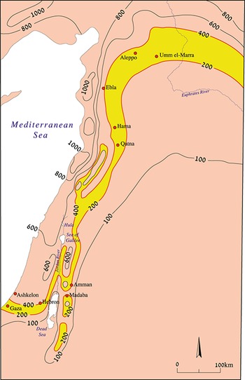
It is doubtful that grain from Canaan was exported to Egypt, as the Nile Valley, Delta, and Fayum Depression were already major centers of grain production (Malleson and El Dorry Reference Malleson and El Dorry2025 and references therein). Likewise, it is unlikely that grain production was intensified solely to support Egyptian troops and administrators in Canaan. Textual and archaeological evidence suggests that, apart from occasional major military campaigns, Canaan was controlled by a relatively small number of Egyptian officials and troops during the LB. Requests in the Amarna letters for as few as 50 or 100 soldiers to quell local conflicts highlight this limited military presence. Instead, the expansion of dry farming in Canaan appears to be linked to the severe dry climate event affecting the Eastern Mediterranean and the ancient Near East toward the end of the LBA (Finkelstein et al. Reference Finkelstein, Langgut, Meiri and Sapir-Hen2017). In the more fertile regions of the SL (Figure 1), such as the Jezreel Valley, a 10–20% reduction in precipitation from the current annual average of ca. 550 mm at Megiddo could have been mitigated through economic planning, particularly under imperial rule. However, prolonged droughts would have posed serious threats to the southern and eastern fringe areas of the Levant, as well as to Anatolia and the north. The critical precipitation range of 200–400 mm annually, which sustained urban centers from Amman in the south through Damascus, Hama, Homs, and Aleppo in the north (Figure 11), would have been particularly vulnerable. Reduced rainfall along this frontier could have led to economic collapse, social unrest, and demographic upheaval – paralleling modern crises in Syria (Gleick Reference Gleick2014; Kelley et al. Reference Kelley, Mohtadib, Cane, Seager and Kushnir2015). The same concerns applied to the southern regions, including Gaza, the Besor basin, and the southern Shephelah (Finkelstein et al. Reference Finkelstein, Langgut, Meiri and Sapir-Hen2017).
The strips between today’s 200–400 mm isohyets representing the borders of the semiarid steppe environment.
No direct textual evidence exists regarding conditions in the southern and eastern fringes of the Levant between 1250 and 1100 BCE. However, it is reasonable to assume that Egyptian administrators sought to prevent chaos in these regions, such as raids on fertile areas by displaced groups, which could have undermined their control over Canaan. Egypt likely viewed the situation in Canaan with both concern and strategic interest. While the Nile region remained relatively insulated from drought-related crises due to its stable river-fed agriculture, the Egyptian empire still needed to act in response to broader climatic challenges in the Near East. Expanding dry farming in the relatively fertile parts of Canaan would have provided an immediate solution to shortages in its southern and eastern peripheries (Finkelstein et al. Reference Finkelstein, Langgut, Meiri and Sapir-Hen2017). Additionally, Canaan was geographically closer to the drought-stricken northern regions than Egypt’s hub, making it a more practical supplier. With well-equipped ports such as Jaffa and Acco, Canaan was well-positioned to facilitate the shipment of grain along the Mediterranean coast to Ugarit and beyond. From Egypt’s perspective, exporting grain to the northern parts of the Levant was likely both economically advantageous and strategically valuable (Finkelstein et al. Reference Finkelstein, Langgut, Meiri and Sapir-Hen2017).
2.3 The Iron Age
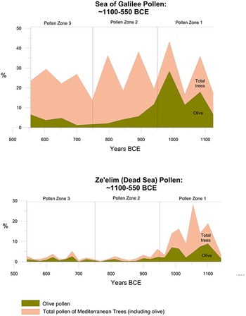
This section explores climatic and environmental conditions of the Iron Age in the SL (ca. 1100–550 BCE) and their possible links to regional settlement patterns. The discussion is based on concise pollen diagrams from the Kinneret and the Dead Sea (Zeʾelim), specifically focusing on the Iron Age (Figure 12; Finkelstein and Langgut Reference Finkelstein and Langgut2018), covering most of the period (ca. 1100–550 BCE; Table 1). These diagrams are divided into three Pollen Zones, reflecting changes in Mediterranean arboreal vegetation and fluctuations in the olive pollen curve.Footnote 16 Drawing on material culture of Iron Age sites and radiocarbon dating of Iron Age strata in the SL, the subdivisions of the Iron Ages have been dated as follows: Iron I (ca. 1100–950 BCE), IIa (ca. 950–780 BCE), IIb (ca. 780–680 BCE), and IIc (ca. 680–586 BCE). The availability of high-resolution SL paleoclimate records, combined with extensive archaeological findings, makes the Iron Age a valuable source of information for examining the interplay between climatological factors and historical and/or geopolitical processes in shaping settlement expansion and contraction in the SL (Greener et al. Reference Greener, Finkelstein and Langgut2018; Finkelstein and Langgut Reference Finkelstein and Langgut2018).
The Kinneret and the Zeʾelim (Dead Sea) simplified pollen diagrams focusing on the Iron Age and divided into pollen zones.
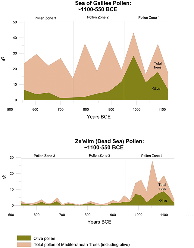
Overall, the arboreal pollen curve of the Kinneret (Figure 12) exhibits numerous minor fluctuations, indicating climate instability. However, significant shifts in the pollen records of Mediterranean and olive trees allow the Iron Age pollen sequence of the Kinneret to be divided into three distinct pollen zones (Figure 12, Table 3). Defining clear pollen zones in the Dead Sea (Zeʾelim) palynological record of the Iron Age (Figure 12) is more challenging. This is primarily because the section corresponding to Iron II reflects intense human impact on the natural environment, with low arboreal pollen percentages likely resulting from extensive deforestation during land clearance rather than climatic factors (Langgut et al. Reference Langgut, Neumann and Stein2014a).Footnote 17 As a result, the Dead Sea sedimentological outcrop is less reliable as a proxy for paleoclimate reconstruction compared to the Kinneret core (Finkelstein and Langgut Reference Finkelstein and Langgut2018). Nonetheless, a sedimentological study conducted on the same Zeʾelim outcrop provides valuable insights into the climatic conditions of the period (Table 3 and Figure 7 c; see Langgut et al. Reference Langgut, Neumann and Stein2014a; Kagan et al. Reference Kagan, Langgut, Boaretto, Neumann and Stein2015). Despite the complexities in interpreting the Zeʾelim data, its overall trends align with those observed in the Kinneret core, allowing for a comparable division into the same pollen zones (Table 3).
Table 3 Long description
Data regarding Mediterranean arboreal pollen and Dead Sea sediment deposition reveal trends in the climate conditions of the SL. Findings indicate that the region experienced humid climate conditions from ca. 1100 to 950 BCE, followed by a period (ca. 950–750 BCE) of sustained relative wetness. By 750–550 BCE, the climate transitioned to a more moderate state.
2.3.1 Iron I
Pollen Zone 1 spans ca. 1100–950 BCE and therefore covers most of the Iron I (ca. 1150–950 BCE; Figure 12). In the Kinneret record, since the beginning of the zone (ca. 1100 BCE) this period is marked by the highest percentages of arboreal pollen (up to 43.2%) and olive pollen (up to 28.5%) of the total pollen count (Figure 12). The expansion of the Mediterranean forest/maquis was driven by an increase in available moisture following the extreme dryness at the end of the LBA. A similar rise in Mediterranean and olive tree pollen is observed in the Dead Sea record exactly at the same time (ca. 1100–950 BCE), where values reach 28.0% and 8.9%, respectively (Figure 12). This trend is also reflected in the Soreq Cave isotopic record (Figure 8) and the Ein Feshkha palynological profile (Figure 5; Neumann et al. Reference Neumann, Kagan, Schwab and Stein2007a), indicating that during the period of ca. 1100–950 BCE, the SL experienced relatively humid climate conditions.
This wetter period followed the arid phase at the end of the LBA and appears to have influenced settlement patterns, particularly in the southern and eastern steppe regions (Figure 11). The settlement wave in the highlands of Cisjordan may have begun as early as the early 12th century BCE, if not slightly earlier. However, radiocarbon data from sites such as Shiloh and el-Ahwat (Sharon et al. Reference Sharon, Gilboa, Jull and Boaretto2007) suggest that its primary phase occurred in the late 12th and 11th centuries BCE. Pottery collected from surveys indicates that early settlements were established in the small valleys along the hill country spine, the Bethel-Gibeon Plateau, and the eastern desert fringe (Zertal Reference Zertal, Finkelstein and Na’aman1994; Finkelstein Reference Finkelstein and Levy1995). These areas were likely chosen due to their suitability for a combination of dry farming and animal husbandry – key elements for sustaining new farms and villages. While the initial settlement wave in the highlands may have been driven by the climate crisis and social upheaval during later phases of the LBA, its expansion took place under improved, wetter conditions, which likely facilitated settlement along the desert fringe. The same trend is observed in the highlands of Transjordan, particularly at sites located on the eastern fringe. A notable example is the large Iron I site of Sahab, situated 12 km southeast of Amman (Ibrahim Reference Ibrahim1987). Similar settlement expansion occurred in western Syria, contributing to the rise of the Aramean kingdoms at the onset of Iron II (Finkelstein and Langgut Reference Finkelstein and Langgut2018 and references therein).
A significant phenomenon from this period is the system of Iron I settlements on the Kerak Plateau, south of Wadi Mujib in Transjordan – an area that today receives ca. 300 mm of rainfall per year (Figure 13; Porter et al. Reference Porter, Xie, Challinor, Field, Barros and Dokken2014; for the regional survey, see Miller Reference Miller1991). Two key sites in this network are the fortified strongholds of Khirbet Medeineh ‘Aliya and Khirbet Medeineh Mu‘arrajeh, both located along the eastern fringe of the plateau and dating to the late Iron I (Routledge Reference Routledge2000; Finkelstein and Lipschits Reference Finkelstein and Lipschits2011; Porter et al. Reference Porter, Xie, Challinor, Field, Barros and Dokken2014). Based on pottery evidence and radiocarbon dating, Khirbet Medeineh ‘Aliya was likely established in the 11th century BCE and abandoned by the mid 10th century BCE (for pottery analysis, see Routledge Reference Routledge2000, Reference Routledge and Grabbe2008; for radiocarbon data, see Porter et al. Reference Porter, Xie, Challinor, Field, Barros and Dokken2014: 135). Despite being located east of the current boundary for permanent agriculture, the site shows evidence of dry farming (Porter et al. Reference Porter, Xie, Challinor, Field, Barros and Dokken2014). Settlement activity in the Kerak Plateau may have been linked to copper mining in Wadi Faynan, ca. 60 km to the south, as well as the transportation of copper northward along the King’s Highway (Finkelstein and Lipschits Reference Finkelstein and Lipschits2011). No doubt, during periods when the area received more than 300 mm of rainfall annually, daily life was more stable, supporting both farming and herding. Copper production at Wadi Faynan (e.g., Khirbet en-Nahas, see Levy et al. Reference Levy, Adams and Najjar2004, Reference Levy, Higham and Bronk Ramsey2008) would also have benefited from improved water availability in ravines draining from the Edomite Plateau into the Arabah. It not only provided water for human needs and for operating the metallurgical operation but also supported denser vegetation cover; thus, wetter periods in the region supplied more fuel – a critical factor for copper production (Cavanagh et al. 2022).
The Kinneret and the Dead Sea drainage basin together with Iron Age sites, palynological records, phytogeographic zones, and rainfall isohyets (based on Zohary Reference Zohary1973, Reference Zohary1982 and Srebro and Soffer Reference Srebro and Soffer2011, respectively).
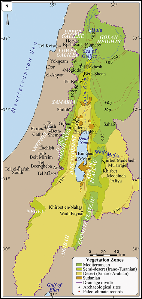
In the Beer-sheba Valley, two MBA sites have been identified, but there is no evidence of LBA settlements. Sedentary activity resumed in the Iron I, with key sites including Stratum III at Masos and Stratum IX at Beer-sheba (Herzog Reference Herzog, Finkelstein and Na’aman1994; for updated chronology, see Herzog and Singer-Avitz Reference Herzog and Singer-Avitz2004: 231). Several sites in the Negev Highlands were first settled in the later phase of the Iron I (Fantalkin and Finkelstein Reference Fantalkin and Finkelstein2006: 20). The Masos–Negev Highlands settlement system, which peaked in the Iron IIa, was linked to the copper industry in the Arabah (Fantalkin and Finkelstein Reference Fantalkin and Finkelstein2006; Martin and Finkelstein Reference Martin and Finkelstein2013; Finkelstein Reference Finkelstein2014). However, since no evidence of agriculture has been found in the Negev Highlands (Shahack-Gross et al. Reference Shahack-Gross, Boaretto, Cabanes, Katz and Finkelstein2014; Langgut and Finkelstein Reference Langgut and Finkelstein2023b), grain supplies must have come from regions farther north.Footnote 18 The wetter conditions characterizing the Iron I (Figure 12) may have supported dry farming in the Beer-sheba Valley on a larger scale than is possible today.Footnote 19An exception to this general pattern is the Judean Highlands, where Iron I settlement activity remained sparse (Table 2). This suggests that demographic expansion during Iron I was not solely determined by climate conditions. The rugged and rocky terrain of the region required significant effort to clear land for agriculture, which may have deterred settlement when more hospitable areas remained relatively unoccupied (Finkelstein and Langgut Reference Finkelstein and Langgut2018).
2.3.2 Iron II
The Iron II (ca. 950–586 BCE) is characterized by the continuation of relatively humid conditions, but a dramatic reduction in olive pollen in the Kinneret as well as in the Zeʾelim palynological diagram. The time interval of ca. 950–550 BCE was further subdivided into Pollen Zone 2 and Pollen Zone 3 (Figure 12 and Table 3).
At Pollen Zone 2 (ca. 950–750 BCE), the arboreal pollen curve of the Kinneret maintains high frequencies similar to Pollen Zone 1, reaching 38.1%, whereas in the Dead Sea, it declines sharply to a minimum of 0.5%. The palynological data suggest that a well-developed Mediterranean forest/maquis and relatively humid climate conditions persisted near the Kinneret. Additionally, the Zeʾelim section’s depositional environment during Iron II is interpreted as a deep lake (Figures 3 and 7 c; Langgut et al. Reference Langgut, Neumann and Stein2014a; Kagan et al. Reference Kagan, Langgut, Boaretto, Neumann and Stein2015), further supporting evidence of a wet climate. The significant decline in Mediterranean tree pollen percentages at Zeʾelim profile, therefore, likely reflects human-induced deforestation rather than climatic change. The rise of territorial kingdoms in the region, beginning in the second half of the 10th century BCE, occurred under favorable climatic conditions for agriculture. These conditions would have supported emerging bureaucratic systems, which likely managed the organization of surpluses, commodity transportation, and agricultural specialization. However, in an era defined by the emergence of kingdoms, international trade, and shifting geopolitical landscapes, climate alone did not dictate settlement patterns. A notable example is the rise of the Aramean territorial kingdoms in western Syria, which can be seen as a case of secondary state formation – a development spurred by the growing power of Assyria. The decline of the early Moabite polity in the Kerak Plateau’s fringe region around the mid 10th century BCE or slightly later occurred despite persisting wet conditions. This suggests that environmental factors were not the primary cause; rather, the shift was likely driven by geopolitical changes. Egyptian intervention in the south during the early days of the 22nd Dynasty (Sheshonq I’s reign) – potentially aimed at monopolizing the copper industry in the Wadi Faynan area – led to a redirection of copper transportation routes. Instead of moving northward via the King’s Highway in Transjordan, copper was now transported northwest through the Beer-sheba Valley to the Mediterranean coast and Egypt. This shift fostered prosperity in the Negev while contributing to the decline of settlements in the Kerak Plateau (Finkelstein and Lipschits Reference Finkelstein and Lipschits2011; Finkelstein Reference Finkelstein2014).
In the Negev Highlands, settlement activity peaked in the early to mid 9th century BCE but declined in the latter half of the century (Shahack-Gross et al. Reference Shahack-Gross, Boaretto, Cabanes, Katz and Finkelstein2014; Langgut and Finkelstein Reference Langgut and Finkelstein2023b). Similarly, copper production in the Faynan region decreased during this period. Both trends occurred despite ongoing relatively wet climate conditions, indicating that climate was not the driving factor. Instead, these economic and settlement declines were likely due to the renewed availability of Cypriot copper, which gradually replaced Arabah-mined copper as the Levant’s primary source (Knauf Reference Knauf and Edelman1995: 112−113; Finkelstein Reference Finkelstein2014). Judah’s expansion into the Beer-sheba Valley during the late Iron IIa was likely facilitated by favorable climatic conditions, though climate itself was not the principal driving force. Instead, Judah’s expansion appears to be linked to its alliance with Damascus, formed after Hazael’s campaign against Gath. The Judahite strongholds at Arad and Beer-sheba may have played a strategic role in helping Damascus suppress copper production in the Arabah, allowing Cypriot copper, shipped via the Phoenician coast, to dominate regional trade (Fantalkin and Finkelstein Reference Fantalkin and Finkelstein2006; Finkelstein Reference Finkelstein2014).
Pollen Zone 3 corresponds to the later phase of the Iron II (ca. 750–550 BCE) and is characterized by moderate climate conditions (Figure 12 and Table 3). In the Kinneret record, arboreal pollen declines slightly (not exceeding 29.4%), while the olive pollen curve shows a gradual increase (from 1.6% to 16.1%). In contrast, the Dead Sea record continues to show low values for both arboreal (≤3.7%) and olive pollen (≤2.6%), although they are slightly higher than in the previous zone. This suggests a minor recovery of the Mediterranean forest/maquis, alongside a modest expansion of olive orchards. The estimated annual precipitation in Soreq Cave is slightly lower than the present-day average (Figure 8).
Both pollen records show their lowest arboreal and olive pollen percentages at nearly the same time (Figure 12): Arboreal pollen values reach their lowest point at ca. 750 BCE in the Kinneret, while in Zeʾelim, this occurs roughly a decade earlier. Olive pollen reaches its lowest levels at ca. 700 BCE in both records. Despite these shifts, the relatively high lake levels reconstructed for Zeʾelim sedimentological sequence during this period (Figure 3; Langgut et al. Reference Langgut, Neumann and Stein2014a; Kagan et al. Reference Kagan, Langgut, Boaretto, Neumann and Stein2015) indicate that relatively humid climatic conditions persisted. A moderate increase in olive percentages after ca. 700 BCE was documented in both the Kinneret and Dead Sea records (Figure 12). The decrease in the extension of the Mediterranean woodland ca. 750 BCE could have been the result of the peak of population growth in the Kingdom of Israel (Broshi and Finkelstein Reference Finkelstein1992), which would have brought about deforestation in order to clear land for agriculture. Growth in the Mediterranean woodland that followed in the 7th century BCE, though moderate, may have been the result of the deportations after Tiglath-pileser’s conquest in 732 BCE (Younger Reference Younger1998). Archaeological surveys show that many of the Iron Age sites in the Lower Galilee were abandoned as a result of the Assyrian takeover (Gal Reference Gal1988–89).
Low arboreal values in the Dead Sea in the second half of the 8th century do not reflect diminishing precipitation, as sediments along the lake were embedded in high lake levels (Figures 3 and 7 c; Langgut et al. Reference Langgut, Neumann and Stein2014a; Kagan et al. Reference Kagan, Langgut, Boaretto, Neumann and Stein2015). Rather, this must reflect the peak of settlement activity and hence deforestation in the Judean Highlands in the Iron IIb-c (Table 2; Ofer Reference Ofer, Finkelstein and Naʾaman1994; Finkelstein and Silberman Reference Finkelstein and Silberman2006a). In this period, too, some of the settlement processes were dictated by geopolitical strategies, sometimes against the sheer logic of the environmental conditions. This is true first and foremost for the dramatic increase in settlement activity in the Edomite Plateau and the Beer-sheba Valley, both probably related to prosperity created by the Assyrian-led Arabian trade, which passed through these regions (Finkelstein and Langgut Reference Finkelstein and Langgut2018). Further details on the region’s specialized economy under Assyrian rule can be found in Section 3.4.
2.4 The Achaemenid Period
This section begins with a synthesis of climate history during the Achaemenid (Persian) Period (539–322 BCE). Then, possible links between dryer climate conditions at the beginning of the period and the dramatic changes in the settlement pattern will be evaluated (Sections 2.4.1 and 2.4.2, respectively).
2.4.1 Climate Reconstruction
Figure 14 provides a summary of key paleoclimatological proxies for the period between ca. 1200 and 300 BCE. Its primary aim is to illustrate the paleoclimate conditions during the Achaemenid period in the context of the preceding centuries. The diagram incorporates major pollen curves from the Kinneret and Dead Sea (Zeʾelim) records, reconstructed Dead Sea levels (Bookman [Ken-Tor] et al. Reference Bookman (Ken-Tor), Enzel, Agnon and Stein2004), and the lithological record from the Zeʾelim outcrop (Figure 7; Langgut et al. Reference Langgut, Neumann and Stein2014a). The consistency among these independent paleoclimate records reinforces the reliability of the findings, which indicate that the region experienced relatively dry climatic conditions from the late 6th century through the first half of the 5th century BCE (ca. 520–450 BCE). This period was followed by a gradual increase in humidity, culminating in significantly wetter conditions by the 4th century BCE. The dry climate conditions during the early phase of the Achaemenid period are evident not only in the decline of arboreal pollen percentages in the palynological records but also in the accumulation of sand layers and aragonite crusts, which indicate deposition in a shoreline environment, pointing to a drop in Dead Sea levels. Collectively, this evidence indicates reduced precipitation across the Dead Sea drainage basin (Figure 13). The Soreq Cave isotopic record shows that annual precipitation was below the modern average, further supporting the presence of dry climate conditions during this period (Figure 8; Laugomer Reference Laugomer2017).
A concise diagram with SL paleoclimate proxies available for the period of ca. 1200–300 BCE.
The arid conditions of the Early Achaemenid period align with broader regional trends, influencing both the Mediterranean and semiarid steppe zones of the SL, which share similar atmospheric dynamics, particularly precipitation driven by mid-latitude Mediterranean cyclones. The dry climate conditions of the period had widespread effects, with evidence of prolonged drought, economic difficulties, and agricultural shortages even in the area surrounding Jerusalem. These challenges are reflected in both the prophetic literature of the Early Achaemenid period and the historiographical narratives of Ezra-Nehemiah (Langgut and Lipschits Reference Langgut and Lipschits2017). The impact of this dry phase was most probably more influential in climatically vulnerable regions such as the southern Hill Country, the northern Negev Desert, and the southern Shephelah (Figure 11), where arid conditions led to a decrease in grazing opportunities and dry farming. The shift toward a wetter climate in the Late Achaemenid and Early Hellenistic periods opened new options for settlement expansion and agricultural development in these marginal areas (Langgut and Lipschits Reference Langgut and Lipschits2017).
2.4.2 Possible Links between Dry Climate Conditions and the Establishment of Idumea
As already outlined, even minor climatic fluctuations can have significant environmental consequences in the steppe-marginal regions of the Levant (Figure 11). The drier conditions from the late 6th to mid 5th centuries BCE (ca. 520–450 BCE), combined with the absence of a dominant political or military force in this arid and remote area, may have played a key role in the widespread abandonment of villages in the southern parts of the former Kingdom of Judah (Figure 15a; Langgut and Lipschits Reference Langgut and Lipschits2017 and references therein). These conditions likely contributed to population shifts, with some inhabitants migrating to the core areas of the province of Yehud, while others may have adopted a more nomadic lifestyle. This period of decline created a demographic vacuum that facilitated the influx of nomadic groups – part of a broader movement that had begun after the fall of the Kingdom of Judah and the collapse of its southern settlements and military infrastructure. Additionally, the successful expansion of Nabonidus into northern Arabia and his relocation to Taymā’ (553–543 BCE) may have led to the dissolution of the Kingdom of Edom and its eventual integration into greater Arabia (Lemaire Reference Lemaire, Lipschits and Blenkinsopp2003: 290). Nabatean, Arab, and Edomite groups migrated into the depopulated areas of the southern former Kingdom of Judah. By the Late Persian and Early Hellenistic periods, their presence is evident in Mareshah and its surrounding region, forming the core population of the province of Idumea (Figure 15b; Zadok Reference Zadok1998; Eshel Reference Eshel, Lipschits, Knoppers and Albertz2007; Graf Reference Graf, Schmid and Mouton2013).
The Kingdom of Judah in the 8th–7th centuries BCE, together with rainfall isohyets (after Srebro and Soffer Reference Srebro and Soffer2011). b. The Provinces of Yehud and Idumea in the 4th–3rd centuries BCE, together with rainfall isohyets.
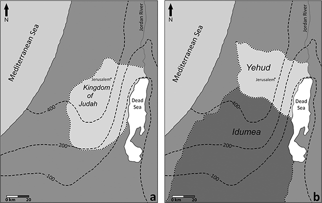
The gradual increase in humidity, which characterized the region in the late 5th and 4th centuries BCE, may have supported a cultural change by stabilizing settlements that were highly dependent on water resources and local agriculture. Seminomadic elements could easily settle in the area and quickly create the settlement alignment of the Province of Idumea (Figure 15b). According to the excavations at Mareshah (Kloner Reference Kloner2003) and according to the archaeological surveys and excavations (see further), it is evident that the major period of change in this area and the crystallization of the new settlement and demographic pattern occurred during the 4th century BCE.
The developments in Idumea and the southwestern parts of Yehud during the 4th century BCE have long been recognized and are generally attributed to the Persian Empire’s reorganization following the Egyptian revolts, when Egypt freed itself from Persian rule (until 343 BCE). At this time, the Achaemenids likely viewed the SL – particularly its southern regions – as a crucial border zone and potential battlefield. This period may have been the most significant for the region since the Babylonian conquest and destruction at the end of the 7th and the beginning of the 6th centuries BCE (Lipschits Reference Lipschits, Lipschits and Oeming2006: 23). Following these events, the Achaemenids consolidated their rule, reorganizing administration and security along the southern coastal plain, the southern Shephelah, and the Beer-sheba–Arad Valley. During this process, a fort was built at Beer-sheba (Stratum H3), which produced about forty Aramaic ostraca dated 359–338 BCE bearing Idumean, Arab, and Judahite names (Kloner Reference Kloner2015: 363–364), and a smaller fort was established at Arad (Stratum V), yielding about eighty-five Aramaic ostraca that attest to its role as a military and administrative center (Kloner Reference Kloner2015: 363–364). The main administrative center at Lachish (Stratum I) was also founded at this time (Fantalkin and Tal Reference Fantalkin, Tal and Ussishkin2004). Most forts and administrative centers along the Negev roads likewise date to this period (Stern Reference Stern2001: 420–421), as do numerous unprovenanced Aramaic ostraca that highlight the importance of the southern Shephelah and the Beer-sheba–Arad Valley to the Persian economy, military, and administration (Lemaire Reference Lemaire, Lipschits and Blenkinsopp2003).
Langgut and Lipschits (Reference Langgut and Lipschits2017) suggested that the improved climate conditions during this period may have been one of the factors contributing to the change in settlement, demography, and history of the area where the province of Idumea developed. This shift may also have enabled seminomadic groups to settle in the southern Judean hills, the southern Shephelah, and the Beer-sheba–Arad Valley, possibly marking a second wave of immigration into this sparsely populated region (Figure 15b). Following the early 6th-century-BCE crisis, settlement in the central and southern Judean Shephelah south of the Elah Valley shows substantial continuity (Lipschits et al. Reference Lipschits, Shalom, Shatil, Gadot, Stiebel, Peleg-Barkat, Ben-Ami and Gadot2014). Of the fifty-five sites occupied in this area during the Achaemenid period, forty-four were already inhabited in the Iron Age, with only eleven newly established. The limited number of new sites likely reflects some degree of aridification. Although historical and archaeological evidence is sparse, it seems probable that Arab and Idumean tribes entered the region gradually, with most inhabitants maintaining a seminomadic lifestyle; significant changes occurred only with climatic improvement in the Late Achaemenid period. Survey data indicate that between the Late Achaemenid and Hellenistic periods, a marked shift took place around Mareshah and Lachish: only 26 of the 55 Achaemenid period sites remained occupied (47%), while 123 new sites were established in their vicinity (Lipschits et al. Reference Lipschits, Shalom, Shatil, Gadot, Stiebel, Peleg-Barkat, Ben-Ami and Gadot2014).
While surveys cannot precisely date the settlement changes, extensive research and salvage excavations suggest that the transformation occurred in the 4th century BCE. Along the Ellah Valley – likely within the borders of the Province of Yehud – a large village existed at Azekah during the Late Achaemenid–Early Hellenistic period, alongside a smaller settlement at nearby Khirbet Qeiyafa (Stratum III). The excavators dated this stratum to the Late Achaemenid–Early Hellenistic period (Garfinkel et al. Reference Garfinkel, Ganor and Hasel2014), and based on pottery and numismatic evidence, Sandhaus and Kreimerman (Reference Sandhaus and Kreimerman2015) refined it to the late 4th–3rd centuries BCE. Evidence from Azekah’s northern and western surroundings indicates continuity in rural settlement (Lipschits Reference Lipschits2005; Shalom et al. Reference Shalom, Lipschits, Shatil, Gadot, Honigman, Nihan and Lipschits2021), as also supported by excavations at Beth-Shemesh (Kogan-Zehavi Reference Kogan-Zehavi, Stiebel, Peleg-Barkat, Ben-Ami and Gadot2014).
During this period, Mareshah became the center of the new province of Idumea (Kloner and Stern Reference Kloner, Stern, Lipschits, Knoppers and Albertz2007). To its southeast, Achaemenid remains were uncovered at Tel ‘Eton, including the foundations of a large building atop the mound and a surrounding small village. Faust et al. (Reference Faust, Katz and Eyall2015) described the building as a fort, though it may also have been a central structure of a village, a farmhouse, or local estate. Based on local and imported pottery, the Achaemenid phase is dated to the 4th century BCE, continuing into the early 3rd century BCE (Faust et al. Reference Faust, Katz and Eyall2015). At Tel Halif, Achaemenid-period building remains, and other scattered artifacts were also excavated (Cole Reference Cole2015), a pattern likely mirrored at Khirbet el-Qom (Kloner and Stern Reference Kloner, Stern, Lipschits, Knoppers and Albertz2007). The Achaemenid residency at Lachish, first dated by Tufnell (Reference Tufnell1953) to the 5th century BCE and later by Fantalkin and Tal (Reference Fantalkin, Tal and Ussishkin2004) to the early 4th century BCE, fits this broader pattern, although its official character and purpose differ from the rural settlements.
In the hill country, a large public building with two Achaemenid phases was excavated at Jabel Nimra, near Tell er-Rumeide (Hebron; Hizmi and Shabtai Reference Hizmi, Shabtai, Erlich and Eshel1993). Pottery and a silver coin suggest the main phase dates to the Achaemenid period, with a second phase in the Late 5th–4th centuries BCE; the structure’s destruction is assigned to the end of the 4th century BCE (Hizmi and Shabtai Reference Hizmi, Shabtai, Erlich and Eshel1993). At Khirbet Lutzifar in the southern Hebron Highlands, 90% of the finds date to the Achaemenid period, though some sherds are from Iron II and Hellenistic periods. Baruch (Reference Baruch and Eshel1995) suggests the site functioned as a local fort and road station, erected in the later Achaemenid period (personal communication).
In summary, shifts in borders, settlement patterns, and demographics in the SL between the 6th and 3rd centuries BCE (Figure 15) reflect broader regional changes in vegetation and climate (Figure 14). Integrating high-resolution climatological and environmental records with archaeological research, which distinguishes Achaemenid phases, has greatly enhanced understanding of this transformative era (Langgut and Lipschits Reference Langgut and Lipschits2017).
2.5 Summary: Climatic Conditions ca. 1300–300 BCE in the Southern Levant
Section 2 presents detailed climate reconstruction in the SL from the end of the LBA to ca. 300 BCE, drawing on high-resolution, well-dated regional paleoclimate records (Figure 14).Footnote 20 During this period, two significant dry events were recorded. The first, which was particularly severe, occurred between the mid 13th and late 12th centuries BCE (ca. 1250–1100 BCE) and was likely a key factor in the collapse of LBA Eastern Mediterranean complex societies. The second, a comparatively brief and less intense dry phase (ca. 520–450 BCE), took place during the Early Achaemenid period and may have contributed to the establishment of Idumea.
Between these events, climatic conditions were initially humid (Iron I–IIa, ca. 1100–750 BCE) and later moderated (Iron IIb–Early Achaemenid period, ca. 750–520 BCE; Figure 16). The wetter conditions of the Iron Age facilitated the expansion of settlement activity in the highlands, fostering the rise of the biblical territorial kingdoms. The alternation between dry and wet climatic phases during the LB–Iron Age transition appears to underscore one of the most dramatic instances of sociopolitical collapse and recovery in the region’s history.
Summary of the climate history of the SL from the Bronze Age to the Achaemenid period, based on palynological and sedimentological evidence.
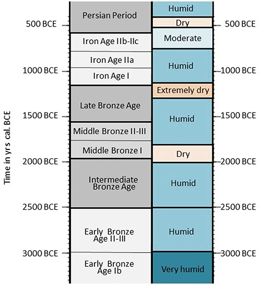
Figure 16 Long description
Early Bronze Age 1b (very humid) runs to about 3000 B C E. Early Bronze Age 2 to 3 (humid) runs to about 2500 B C E. Intermediate Bronze Age (humid) runs to about 1950 B C E. Middle Bronze ages 1 (dry), 2, and 3 (humid) run to about 1650 B C E. Late Bronze Age (humid, then extremely dry) runs to about 1150 B C E. Iron Ages 1, 2a (humid), 2b, and 2c (moderate) run to about 600 B C E. Following this is the Persian Period (dry, then humid).
3 Environmental History
Section 3 begins with an attempt to reconstruct the natural environment of the SL during the period between ca. 1300 and 300 BCE (Section 3.1). Subsequently, different forms of human impact on the natural environment – including deforestation, orchard cultivation, hillside terracing, overgrazing, and the introduction of nonnative plant species – are examined (Section 3.2). The evidence for reconstructing both natural and anthropogenic environments is partial and fragmented. Nevertheless, this section aims to compile the relevant data to shed light on these issues. The information includes pollen data, charcoal assemblages, and other sources. At the end of the section, an attempt is made to examine the effects of political-economic strategies on the surrounding region, regardless of any climate change (Section 3.3).
3.1 The Woody Landscape
This section mainly uses large-scale charcoal assemblages that were recovered from SL sites with long occupation histories (Liphschitz Reference Liphschitz2007 and references therein; Benzaquen et al. Reference Benzaquen, Finkelstein and Langgut2019; Jin et al. Reference Jin, Lipschitz and Langgut2024), in order to reconstruct the natural woody landscape during the period of ca. 1300–300 BCE. Based on these assemblages, it is evident that the SL natural Mediterranean woodland primarily consisted of oaksFootnote 21 and pistachio (Pistacia spp.) species. Over time, a gradual degradation of this woodland was observed. This trend is particularly evident at Megiddo, where the charcoal assemblages (Benzaquen et al. Reference Benzaquen, Finkelstein and Langgut2019 and references therein; Ahola Reference Ahola2023) show a decline in local conifer species, such as Mediterranean cypress (Cupressus sempervirens) and Aleppo pine (Pinus halepensis). This reduction likely resulted from overexploitation, particularly for construction purposes. Mediterranean cypress and Aleppo pine were the most suitable timber sources in the Mediterranean woodland, providing the straightest and longest logs, which were easy to work with and highly resistant to insects and fungi (e.g., Benzaquen et al. Reference Benzaquen, Finkelstein and Langgut2019). The percentages of common wild arboreal species – such as oaks, pistachio, and azarole (Crataegus spp.) – also decrease over time, though more gradually. A noticeable increase in taxonomic diversity is observed in the later periods (Iron I‒II), marked by the presence of species like Syrian maple (Acer syriacum), Judas tree (Cercis siliquastrum), Palestine buckthorn (Rhamnus palaestinus), tamarisk (Tamarix spp.), and Euphrates poplar (Populus euphratica). The inhabitants of Megiddo likely turned to these less suitable species for construction and carpentry when preferred timber sources became scarce (Benzaquen et al. Reference Benzaquen, Finkelstein and Langgut2019).
Currently, only one large-scale charcoal assemblage from the desert areas of the SL is available for the periods in question, originating from the LB–early Iron I copper industry in the Timna Valley (Cavanagh et al. Reference Cavanagh, Ben-Yosef and Langgut2022). The assemblage, representing metallurgical fuel remains, indicates a desert vegetation landscape similar to today’s conditions. The study shows a heavy reliance on local species such as white broom and acacia, both efficient fuel sources. Over time, the inclusion of taxa unsuited to local conditions suggests expanding fuel procurement and increasing environmental stress. Cavanagh et al. (Reference Cavanagh, Ben-Yosef and Langgut2022) propose that fuel shortages and anthropogenic desertification ultimately contributed to the industry’s decline.
3.2 Human Influence on the Natural Environment
3.2.1 Fruit Tree Horticulture
The main five founders that established fruit tree horticulture are the olive (Olea europaea), grapevine (Vitis vinifera), date palm (Phoenix dactylifera), common fig (Ficus carica), and pomegranate (Punica granatum). It was suggested in the literature that the SL served as a core area for fruit tree cultivation (Zohary and Spiegel-Roy Reference Zohary and Spiegel-Roy1975; Weiss Reference Weiss2015; Langgut Reference Langgut2024).Footnote 22 Today, these fruit trees significantly contribute to human diet in many countries and to global trade.
Oleiculture
Olive (Olea europaea) played a crucial role in antiquity, significantly shaping the Levantine economy while also serving cultural, religious, and medicinal purposes (Zohary et al. Reference Zohary, Hopf and Weiss2012: 116). Archaeological evidence points to the Carmel Coast – and possibly the Galilee – as an early global center of olive cultivation (Langgut Reference Langgut2024 and references therein). The recent discovery of wild olives along the Carmel Coast supports this (Ben-Dor et al. Reference Ben-Dor, Dag and Perelberg2024). Charcoal remains from all SL sites in the Mediterranean zone show that since the EBA, olive wood has dominated, often making up 50–80% of assemblages (Figure 17; Liphschitz Reference Liphschitz2007; Langgut and Lev-Yadun Reference Langgut, Lev-Yadun, Nikita and Rehren2024).Footnote 23 This high frequency is likely linked to the common practice of pruning, a necessary technique for increasing fruit yield and ease the harvest (Zinger Reference Zinger1985: 94–95). Since pruning waste needed to be removed to prevent fungi and disease spread in the orchards, it was likely shifted to the nearby settlements, where it served as an accessible and readily available fuel source with a high calorific value (Langgut and Lev-Yadun Reference Langgut, Lev-Yadun, Nikita and Rehren2024).
Reconstruction of the arboreal vegetation of the Shephelah from the MBA through the Hellenistic period based on the charred-wood assemblages from Azekah (Jin et al. Reference Jin, Lipschitz and Langgut2024) and Lachish (Liphschitz Reference Liphschitz and Ussishkin2004).
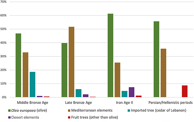
Figure 17 Long description
The y-axis lists percentages from0 to 70, while the x-axis lists the four ages. Each age has 5 bars: Olea europaea (olive), Mediterranean elements, Imported tree (cedar of Lebanon), Desert elements, and Fruit trees (other than olive). The values are as follows. Middle Bronze Age: 48; 33;19; 1; 0.5. Late Bronze Age: 40; 51; 5; 2; 0.5. Iron Age 2: 61; 26; 4; 8; 1. Persian or Hellenistic periods: 56; 36; 0; 0; 9. All values are approximate.
Langgut et al. (Reference Langgut, Lev-Yadun and Finkelstein2014b) show that rehabilitating abandoned olive orchards is quick and technically simple,Footnote 24 enabling a substantial increase in yield without the long wait required for new orchards. This efficiency may have influenced the reoccupation of the same sites during periods of intensified settlement in antiquity, reflecting a preference for resettling near abandoned orchards.
Pollen curves (Figs. 5, 13, 14) illustrate Olea cultivation during the periods under study.Footnote 25 During LB I–III, olive pollen was low compared to earlier periods (Fig. 5), reflecting its limited cultivation in the Galilee and Judean Highlands. This is also evident in the Jezreel Valley and Shephelah charcoal assemblages (Fig. 17; Benzaquen et al. Reference Benzaquen, Finkelstein and Langgut2019; Jin et al. Reference Jin, Lipschitz and Langgut2024). The restricted spread of olive horticulture during the LBA was not climate-related, as the region experienced precipitation above today’s average for most of the period covering the LB I and II (Figure 8). It was only in the mid 13th century BCE that conditions became significantly drier. The low presence of olive pollen and charcoal during the early phases of the LBA is likely linked to a decline in settlement activity during this time (Table 2).
Evidence suggests that olive cultivation in the LBA was primarily for local consumption, while periods of peak olive frequencies have been linked to both local use and olive oil exportation (Langgut et al. Reference Langgut, Adams and Finkelstein2016). Palynological data from Tell Sukas on the Syrian coast support this scenario. High olive pollen percentages in the northern record characterize the EB II–LB period, but a sharp decline began in the Iron I (Langgut et al. Reference Langgut, Adams and Finkelstein2016: fig. 4 c; Sorrel and Mathis Reference Sorrel and Mathis2016: fig. 5a).Footnote 26
Following limited olive cultivation during the LBA in the SL, a significant increase occurred in the Iron I (Figures 12 and 14). The Kinneret pollen diagram reveals a dramatic rise in olive pollen starting in the late 12th century BCE, peaking in the early 10th century BCE – the highest representation of olive pollen since the EB I (Figure 5). This increase reflects the expansion of olive orchards and coincided with the recovery of urban centers in northern Canaan after the LBA dryness. By the late Iron I (late 11th to mid 10th centuries BCE), major urban centers emerged in the valleys, the Lower Galilee, and the Central Highlands, resembling a revival of the LB city-state system (Finkelstein Reference Finkelstein and Levy1995, Reference Finkelstein, Dever and Gitin2003). Large-scale olive oil production is also evident from the Shephelah (Bunimovitz and Lederman Reference Bunimovitz and Lederman2009), suggesting that output exceeded local demand, possibly for export, primarily to Egypt. The Zeʾelim pollen diagram also indicates rising olive pollen percentages in the Iron I (Figure 14). Since the Hebron Highlands are unsuitable for olive cultivation, and settlement in the Judean Highlands was sparse (Table 2), the pollen may have been transported to the Dead Sea via the Jordan River from the Kinneret or carried by northwesterly winds from the Jerusalem area. This hypothesis is supported by the Ein Feshkha pollen record, which shows an olive pollen increase at the beginning of the Iron I (Figure 5).
A sharp decline in olive pollen around 950 BCE was documented in both the Kinneret and Dead Sea palynological records (Figure 14). The reduction in the Kinneret diagram may be linked to the destruction of late Iron I cities in the north, particularly Kinneret and Tel Rekhesh, which are in proximity to the Kinneret core (Figure 13; Finkelstein and Langgut Reference Finkelstein and Langgut2018). Subsequently, the Kingdom of Israel may have promoted olive cultivation in the Samaria Highlands, as suggested by the 8th-century-BCE Samaria ostraca, which document oil shipments to the capital (Niemann Reference Niemann2008). However, neither the Kinneret nor the Dead Sea pollen diagrams capture the vegetation of this region due to their geographic limitations. The drastic decline in olive pollen in the Kinneret diagram during the late 8th century BCE (Figures 12 and 14) may reflect depopulation following Assyrian deportations, which led to the abandonment of olive orchards (Finkelstein and Langgut Reference Finkelstein and Langgut2018). By the 7th century BCE, the olive oil industry had shifted to the Shephelah as part of the Assyrian-specialized economy (detailed in Section 3.3). The reduced olive pollen levels at the beginning of the Achaemenid period may be attributed to drier climatic conditions. However, since the mid 5th century BCE, both pollen and charcoal evidence indicates large-scale olive horticulture in the different regions of the SL (Figures 14 and 17).
Other Local Fruit Trees
While the founder species – olive, grape, fig, and pomegranate – are native to the Levantine Mediterranean climate, the date palm is especially well suited to the desert oasis regions of the Near East and North Africa. Notably, all species of Phoenix are dioecious, necessitating early recognition of sex, a practice documented as early as the time of Hammurabi (1792–1750 BC; Zohary et al. Reference Zohary, Hopf and Weiss2012:131). Assyrian murals from the 10th century BCE depict scenes of artificial pollination of date palms (Bryant Reference Bryant and Calhoun1989). Archaeobotanical evidence from the Chalcolithic period onward suggests that the Dead Sea region functioned as a center for date palm cultivation (Langgut Reference Langgut2024). Theophrastus (4th century BC) described the area around the Dead Sea as renowned in antiquity for the variety of dates cultivated in its orchards (Historia Plantarum II.6:6–7). Pliny the Elder (1st century CE) references the dates from Jericho as the most famous (Natural History XIII.9:44).
Other fruit trees, including grape, common fig, pomegranate, Persian walnut (Juglans regia), and almond (Amygdalus communis), were also cultivated in orchards near SL sites, though their dendroarchaeological remains are profoundly lower than olive remains (e.g., at Lachish, see Liphschitz Reference Liphschitz and Ussishkin2004; Megiddo, see Benzaquen et al. Reference Benzaquen, Finkelstein and Langgut2019, Ahola Reference Ahola2023; Azekah, see Jin et al. Reference Jin, Lipschitz and Langgut2024). This pattern is also evident in the pollen record, while olive is well represented in regional pollen diagrams, other fruit trees appear in very low frequencies or are absent. This discrepancy is due to differences in pollen dispersal mechanisms; olive is wind-pollinated, allowing for broader pollen distribution, whereas most other fruit trees are insect-pollinated, characterized by a low pollen dispersal mechanism.Footnote 27
Grape, a naturally occurring species in the SL, also held significant economic and religious importance (Zohary et al. Reference Zohary, Hopf and Weiss2012: 121). Grape wood is often under-represented in the archaeological record due to its low density (e.g., Benzaquen et al. Reference Benzaquen, Finkelstein and Langgut2019).Footnote 28 However, based on the archaeological evidence of wine presses and grape pit assemblages, it seems that by the EBA grape cultivation was well established in the SL. The history of viticulture in the region was recently reviewed by Deckers et al. (Reference Deckers, Riehl and Meadows2024).
The common fig, native to the region, is believed to have been cultivated in the SL since ca. 5000 BCE (Langgut Reference Langgut2024). It has played a significant role in the SL, both as a staple crop and for its deep symbolic meaning, as recently reviewed by Lev-Yadun (Reference Lev-Yadun, Flaishman and Aksoy2022). Persian walnut (Juglans regia) is a very rare component of the natural flora in the SL (Langgut Reference Langgut2015). The knowledge of its cultivation potential, and possibly even its genetic material, may have been introduced from elsewhere. Archaeobotanical evidence indicates that Persian walnut began appearing more frequently in the SL ca. 1800 BCE. The walnut is mentioned only once in the bible, in Song of Songs 6:11. Based on interpretations of this text, other Hebrew sources, and available palynological data, it is evident that by the Achaemenid period, the Persian walnut was well established in the SL (Langgut Reference Langgut2015).
Until recently, it was assumed that the pomegranate was not native to the SL. However, a study reviewing all available regional archaeobotanical evidence suggests that during prehistoric periods, pomegranate was always present in the region, though it remained a rare element. From the EBA onward, pomegranate remains became more prevalent, likely indicating its cultivation in the region (Langgut Reference Langgut2024).
3.2.2 Terracing the Landscape
Farming terraces represent one of the most widespread forms of agricultural landscapes in hilly and mountainous regions. Terraces are a highly visible feature in many agricultural landscapes, shaping both the physical terrain and human interaction with it. Their stepped structures interrupt natural slopes, creating horizontal platforms that control water flow, reduce erosion, and maximize arable land. In many regions, they reflect long-term land management practices and serve as enduring markers of human adaptation to challenging topography (Arnáez et al. Reference Arnáez, Lana-Renault, Lasanta, Ruiz-Flaño and Castroviejo2015). In the Jerusalem Highlands, terraces covered more than 60% of the landscape (Ron Reference Ron1977) and significant portions of the Judean Highlands further south. In the SL, the highlands were primarily used for rainfed fruit tree cultivation, while the plateau areas were mainly dedicated to irrigated grain cultivation (Figure 4).
Until recently, it was commonly accepted in the research that the intensive plantation economy in the hill regions of the SL, which began in the EB (Deckers et al. Reference Deckers, Riehl and Meadows2024; Mor et al. Reference Mor, Greenberg and Langgut2025), was supported by terrace systems. However, OSL (Optically Stimulated Luminescence) dates from recent years contradict this claim. The new dates indicate that large-scale terracing in the hill country began only in the Hellenistic period. Limited evidence from Nahal Shmuel (northwest of Jerusalem) suggests that the process may have started as early as the end of Iron Age II (Gadot et al. Reference Gadot, Elgart-Sharon and Ben-Melech2018; Ben-Melech et al. Reference Ben-Melech, Zeevi-Berger and Porat2024). How, then, were orchards cultivated in the hill regions without terraces? Davidovich et al. (Reference Davidovich, Farhi and Kol-Ya’akove2006) proposed that they were grown in soil pockets through intensive stone-clearing activities. It is also possible that the orchards were not cultivated in the hill regions at all, but rather on the lower slopes and in the plains. Palynological evidence supports these observations. According to Baruch (Reference Baruch, Bottema, Entjes and Van-Zeist1990), intensive fruit tree cultivation in the highlands of Galilee and Judea began only during the Roman period. Pollen data indicate that between the Chalcolithic and the Roman era, there was no significant decrease in Mediterranean woodland pollen, suggesting that the highland woodlands remained largely intact (Baruch Reference Baruch, Bottema, Entjes and Van-Zeist1990).
3.2.3 Deforestation and Overgrazing
The pollen evidence of the Zeʾelim sequence indicates that during the 8th–7th centuries BCE, human impact on the Judean Highlands reached its zenith (Langgut et al. Reference Langgut, Neumann and Stein2014a). The sporadic presence and low percentages of the two oak types (evergreen and deciduous) may reflect deforestation in the Judean Highlands, while the near-total disappearance of pines – a pioneer species in Mediterranean forest regeneration – suggests that the region’s Mediterranean maquis/forest was under intense anthropogenic pressure (Figure 3). Indeed, the surge in human activity that began in the Iron I reached its peak during Iron IIb-c (8th–7th centuries BCE), with 520 settlements documented in the hill country, including a peak in the Judean Highlands (Table 2; Broshi and Finkelstein Reference Finkelstein1992; Ofer Reference Ofer, Finkelstein and Naʾaman1994).
The pollen data from the Dead Sea also suggest increased grazing activity in the Judean Highlands and possibly Moab during the Iron II (Figure 3; Langgut et al. Reference Langgut, Neumann and Stein2014a). The continuous presence of grazing-resistant plants (mainly thorny plants and therefore inedible, such as the Carduus-Centaurea group), which reached their highest percentages at the beginning of the Iron II (up to 8.6%), indicates a rise in livestock grazing. Notably, these pollen types peak while grasses remain low or even absent, suggesting the spread of non-palatable thorny herbs and shrubs such as the Carduus-Centaurea group and white wormwood (Artemisia herba-alba), a species common in the region (Zohary Reference Zohary1982). This pattern (Figure 3) is consistent with overgrazing. Archaeozoological evidence further supports this trend, showing an increased reliance on livestock from the Bronze Age to the Iron Age (Grigson Reference Grigson and Levy1995; Hesse and Wapnish Reference Hesse, Wapnish and Collins2002; Sapir-Hen et al. Reference Sapir-Hen, Gadot and Finkelstein2014). Other secondary anthropogenic indicators, such as plants from the buckwheat family (Polygonaceae) – adapted to thrive under human disturbance – also reach their highest distribution during this time (Figure 3). Collectively, these palynological indicators align with archaeological evidence of extensive human impact on the Judean Highlands vegetation.
The long-term effects of this human intervention (deforestation, overgrazing) likely led to reduced vegetation cover, resulting in higher runoff, increased soil erosion, and lower groundwater infiltration. Additionally, the intensive agriculture indicated by extensive olive horticulture in earlier periods may have accelerated soil degradation. The decline in Mediterranean woodland cover during the Iron II was likely driven by a combination of slightly decreased precipitation and significant human-induced stress on the environment, as is also evident based on the SL charcoal assemblages (Section 3.2.1).
3.2.4 The Introduction of Nonnative Trees
Since the LBA, remains of nonindigenous sycamore fig (Ficus sycomorus) wood have appeared in relatively high proportions in the dendroarchaeological assemblages of the SL. It has been suggested that the species was introduced to the region from Egypt during the New Kingdom (Liphschitz Reference Liphschitz2007: 114; Jin et al. Reference Jin, Lipschitz and Langgut2024). In Egypt, the sycamore fig was associated with the Sycamore Goddess (Ben-Dor Evian and Gichon Reference Ben-Dor Evian and Gichon2024). While its fruits are edible, the tree was primarily valued for its timber (Kislev Reference Kislev, Schwarz, Amar and Zifer2000; Zohary et al. Reference Zohary, Hopf and Weiss2012: 130). The cultivation of sycamore fig in the SL is mentioned in biblical texts (1 Kgs 10:27; 2 Chr 1:16). Additionally, the Assyrian Lachish relief depicts the sycamore fig alongside olive and grapevine (Kislev Reference Kislev, Schwarz, Amar and Zifer2000). During the Achaemenid period, Theophrastus recorded that in Egypt, the species was commonly used for both its fruit and timber (Historia Plantarum 4:2). Dendroarchaeological evidence further indicates that this wood was used in construction – particularly for planks and beams – as well as for crafting objects such as coffins and furniture (Gale and Cutler Reference Gale and Cutler2000: 113–115).
Another nonnative species used for construction and toolmaking was the cedar of Lebanon (Cedrus libani). However, unlike the sycamore fig, its fruit was not consumed, and it was not cultivated in the SL. Instead, cedar beams and artifacts were imported from the Northern Levant. Cedar was regarded as a prestigious timber, prized for its straight beams, durability, and pleasant aroma. As a result, it was typically reserved for monumental architecture, as evidenced by dendroarchaeological finds from SL sites (Lev-Yadun et al. Reference Lev-Yadun, Michal, Ezra and Ragna1996; Liphschitz Reference Liphschitz2007: 116–117; Faust et al. Reference Faust, Katz and Sapir2017; Benzaquen et al. Reference Benzaquen, Finkelstein and Langgut2019). The commerce of this high-quality timber during the Iron Age is referenced in biblical accounts (1 Kings 5:15–25, 6:18, 9:11), which describe Hiram, King of Tyre, trading cedars with King Solomon.
Another nonindigenous tree, the citron (Citrus medica), first appeared in the regional archaeological record during the Achaemenid period (Langgut et al. Reference Langgut, Gadot, Porat and Lipschits2013b). Although its fruit is edible, it was introduced primarily as a prestigious ornamental plant. Its earliest evidence in the Mediterranean comes from citron pollen found at the Persian royal garden at Ramat Rahel near Jerusalem (Langgut et al. Reference Langgut, Gadot, Porat and Lipschits2013b). It arrived in the region from India via Persia and gradually became integrated into Jewish culture and tradition. Despite being one of the four species used by Jews during Sukkot, the citron is not mentioned in the bible. The association between the citron and the “fruit of the goodly tree” described in Leviticus 23:40 was only established in the 1st century CE (Langgut Reference Langgut2015). Other nonlocal trees identified in the palynological spectrum at Ramat Rahel include cedar and birch, while local fruit trees and ornamental plants found in the garden included grape, common fig, olive, Persian walnut, myrtle, willow, water lilies, and poplar (Figure 18; Langgut et al. Reference Langgut, Gadot, Porat and Lipschits2013b).
A suggested reconstruction of the 5th- to 4th-century-BCE Persian royal garden of Ramat Rahel (near Jerusalem).
3.3 Political Influence on the Environment: Judah under Assyrian Rule as a Case Study
This section demonstrates that shifts in economic strategies are not necessarily linked to climatic changes. The case study focuses on the economy of Judah during the “Assyrian Century” (ca. 730–630 BCE). For most of this period, the SL experienced relatively mild and stable climatic conditions, without evidence of any severe environmental crisis. Nevertheless, a profound transformation occurred, from a “mixed Mediterranean economy” to a more “specialized economy” strategy.Footnote 29 Changes in the subsistence strategy were, of course, also reflected in the landscape and environment.
Judah’s geography is unique among the territorial kingdoms of the Levant, encompassing four distinct geographical units: the Highlands, the Shephelah (hilly lowlands), the Beer-sheba Valley, and the Judean Desert, including the shores of the Dead Sea (Figure 4). This division is reflected in the biblical text, notably in the town list of Joshua 15. Each unit varies in rock formations, topography, climate, and vegetation (Figures 1 and 4), offering distinct subsistence opportunities that shaped different settlement patterns (Finkelstein et al. Reference Finkelstein, Gadot and Langgut2022).
Until the late Iron IIa, Judah’s territory was primarily confined to the southern highlands, resembling the extent of the LBA city-state of Jerusalem. Expansion into the Shephelah occurred in the late Iron IIa, either before or after the destruction of Gath in the mid 9th century BCE (Fantalkin and Finkelstein Reference Fantalkin and Finkelstein2006; Na’aman Reference Na’aman2013; Sergi Reference Sergi2013). Around the same time, Judah extended its reach into the Beer-sheba Valley, following the decline of the Tel Masos desert polity (Figures 13 and 15a; Finkelstein Reference Finkelstein2014). The Judean Highlands, with their rocky terrain, remained sparsely settled until the late Iron IIa, when a significant demographic expansion began south of Jerusalem. Settlement activity surged in the Iron IIb and continued uninterrupted into the Iron IIc (Table 2). Similar trends were observed in the settlement history of Jerusalem, the capital of the kingdom of Judah (Figure 15a). In the Shephelah, settlement remained sparse during the Iron I and early Iron IIa, but population growth accelerated in the late Iron IIa and peaked in the Iron IIb. Sennacherib’s campaign in 701 BCE inflicted severe destruction on the region, but gradual recovery followed. Notably, around 700 BCE, olive pollen levels in both the Kinneret and Dead Sea palynological records reach their lowest percentages throughout the entire Bronze and Iron ages (Figures 5 and 12). This decline may be linked to Sennacherib’s 701 BCE campaign, which likely led to depopulation due to deportation and the subsequent neglect of olive orchards. During the Iron IIc, settlement patterns shifted, with activity concentrated in major towns rather than in smaller villages and isolated farmhouses. In the Beer-sheba Valley, Iron IIa activity was limited to a few key sites, such as Beer-sheba and the fort at Arad (Figure 13). Settlement expanded in the Iron IIb and persisted into the Iron IIc. Meanwhile, significant habitation in the Judean Desert and along the shores of the Dead Sea appears only in the Iron IIb–c (Finkelstein and Silberman Reference Finkelstein and Silberman2006a; Mashiach and Davidovich Reference Mashiach and Davidovich2024).
Recent studies demonstrated that under Assyrian hegemony, the economy of Judah was transformed from a traditional Mediterranean subsistence to a sophisticated, region-based, specialized economy (Finkelstein et al. Reference Finkelstein, Gadot and Langgut2022; Langgut and Gadot Reference Langgut, Gadot, Boda and Rom-Shiloni2024). As a compliant vassal, Judah profited from the opportunities offered by the empire’s globalized economy.Footnote 30 The Assyrian Empire shaped every aspect of life in the kingdom; this can be observed in privately owned objects such as seals (Winderbaum Reference Winderbaum, Amit, Stiebel, Peleg-Barkat and Ben-Ami2012), architecture (Ussishkin Reference Ussishkin1995; Gadot and Bocher Reference Gadot, Bocher, Farber and Wright2018), the composition of texts (e.g., Van-Seters Reference Van-Seters1990), cult and religion (e.g., Ornan Reference Ornan2005), and, perhaps most importantly, in administration. Judah’s unique geographical setting, with its diverse topography and climate (Figures 1 and 4), along with access to international roads in the south and west, laid the foundation for these developments (Finkelstein et al. Reference Finkelstein, Gadot and Langgut2022).
Under Assyrian rule, the kingdom strategically utilized its diverse ecological niches. The highlands west of Jerusalem became a center for viticulture (Finkelstein et al. Reference Finkelstein, Gadot and Langgut2022: table 1),Footnote 31 a trend that likely extended to the Judean hill country south of the city. Jerusalem is located east of the central highland watershed on the fringe of the Judean Desert (Figures 4 and 13). Today, its immediate surroundings (1–3 km from the Old City) are characterized by inhospitable, rocky terrain, and it seems that similar conditions typified the region in the past, as very few archaeological sites of any kind or from any period have been uncovered in this area (Gadot Reference Gadot2015). In contrast, the area northwest, west, and southwest of Jerusalem is characterized by two major valleys (= wadi beds), the Soreq and Rephaʾim Valleys, which merge ca. 10 km southwest of the city. Together with their tributaries, these valleys served as the “breadbasket” of ancient Jerusalem (Edelstein and Gibson Reference Edelstein and Gibson1982). Their wadi beds hold rich alluvial soil suitable for dry farming, and some small springs. The hills located immediately to the east of the city could have been utilized primarily for herding (Finkelstein et al. Reference Finkelstein, Gadot and Langgut2022; Langgut and Gadot Reference Langgut, Gadot, Boda and Rom-Shiloni2024).
The Iron II, particularly the 7th century BCE, saw a remarkable intensification of rural activity around Jerusalem, especially in the fertile Soreq and Rephaʾim valleys (Gadot Reference Gadot2015; Gadot et al. Reference Gadot, Mizrahi, Freud, Gellman, Čapek and Lipschits2019). Previous studies identified sixty-five sites in the region, with additional excavations since revealing more, some of which are crucial for understanding early 7th-century-BCE Jerusalem. The accumulated data from these excavations have provided insights into the distinct functions of certain sites and the hierarchical relationships between them (Finkelstein et al. Reference Finkelstein, Gadot and Langgut2022). Archaeological evidence indicates the cultivation of previously unused rocky terrain, with most plots dedicated to a single commodity: wine (Langgut and Gadot Reference Langgut, Gadot, Boda and Rom-Shiloni2024). For instance, excavations on the eastern slope of Nahal Shmuel revealed that this inhospitable terrain was adapted for viticulture during the Iron IIc. Grapevines were planted in soil pockets between rock outcrops, likely cultivated without trellises. Instead, they were grown directly on the ground, a local traditional method in wine production that promotes fruit ripening due to the heat absorbed from the soil (Langgut and Gadot Reference Langgut, Gadot, Boda and Rom-Shiloni2024). The shift to viticulture in the highlands is further supported by a significant decline in olive pollen ratios and a minor rise in grape pollen percentages during the late Iron Age (Figures 2 and 3). North of the capital, the Gibeon plateau was likely used for grain cultivation, with some areas also supporting viticulture. Additionally, parts of the viticulture industry northwest, west, and southwest of Jerusalem appear to have been managed as royal estates (Finkelstein et al. Reference Finkelstein, Gadot and Langgut2022).
While the archaeological evidence points to the expansion of viticulture in the Judean Highlands rather than Oleiculture during the late Iron Age, an opposite picture emerges for the Shephelah. Olive pollen from the Shephelah cannot be detected in Dead Sea palynological records due to the natural barrier formed by the Judean Highlands (Finkelstein and Langgut Reference Finkelstein and Langgut2018).Footnote 32 Additionally, no mid-to-late Holocene palynological records are available west of the watershed. The identification of the olive oil industry based on charred wood remains from Shephelah sites is challenging, as charcoal assemblages recovered from Iron Age strata were often grouped without differentiation between subphases of the period (Lipschitz Reference Liphschitz2007). Despite this limitation, the widespread presence of olive oil production installations in the Shephelah provides clear evidence of large-scale olive horticulture during the late Iron II. Olive oil presses were typically located near orchards to minimize transportation and to ensure that oil extraction occurred within 48 hours of harvest, preventing the fruit from becoming bitter (Zinger Reference Zinger1985; Langgut and Gadot Reference Langgut, Gadot, Boda and Rom-Shiloni2024).
The earliest known evidence of intensive olive oil production comes from Philistine Tell es-Safi/Gath, where multiple installations dating to the late Iron IIa (9th century BCE) were discovered in the lower city, suggesting a well-established industry before the rise of the Assyrian Empire (Maeir et al. Reference Maeir, Welch and Eniukhina2021). However, the Assyrian conquest of Philistine city-states appears to have accelerated the region’s specialization in olive oil production. At Ekron, an unprecedented and highly organized olive oil industry emerged during Iron IIb–IIc, with over 115 installations featuring standardized olive presses spread across the site (Gitin Reference Gitin1990, Reference Gitin2003; Eitam Reference Eitam, Eitam and Heltzer1996). Additional olive oil production facilities from the late Iron Age have also been documented at Tell Batash, where installations similar to those at Ekron were uncovered (Mazar Reference Mazar1997: 262–263). Olive oil presses dated to the late 8th century BCE have also been reported at Tell Beit Mirsim and Beth-Shemesh (Eitam Reference Eitam1979; Bunimovitz and Lederman Reference Bunimovitz and Lederman2009). The large number of lmlk storage jars recovered from Stratum III at Lachish may also be linked to Judahite olive oil production in the Shephelah, possibly indicating royal oversight of its distribution (Lipschits et al. Reference Lipschits, Sergi and Koch2011: 10). Additionally, the Lachish reliefs provide visual testimony of the region’s agricultural landscape during the late Iron Age, depicting extensive olive orchards (Kislev Reference Kislev, Schwarz, Amar and Zifer2000). Recent salvage excavations in the eastern part of Beth-Shemesh have revealed new insights into the site’s history after 701 BCE, suggesting that it continued to thrive into the 7th century BCE. Evidence of extensive olive oil production includes fourteen olive presses, similar to those found at other contemporary sites. Notably, while earlier occupation phases featured olive presses within the city, the 7th-century-BCE installations were situated in the lower part of the tell, likely forming part of an industrial zone on the settlement’s periphery (Z. Lederman, personal communication; Gross Reference Gross2021; Maeir et al. Reference Maeir, Welch and Eniukhina2021). This shift suggests a centralized administration that reorganized and intensified olive oil production, consolidating industrial activities outside the main residential area (Finkelstein et al. Reference Finkelstein, Gadot and Langgut2022; Langgut and Gadot Reference Langgut, Gadot, Boda and Rom-Shiloni2024).
The classic olive-growing regions of the SL are the Samaria Highlands and western Galilee (Government of Palestine 1942–1943). Archaeological surveys indicate that the northern Samaria Highlands did not experience a significant demographic decline after 720 BCE (Zertal Reference Zertal1990). However, settlement activity in the southern part of the region, closer to Judah’s border, may have declined (Finkelstein and Silberman Reference Finkelstein and Silberman2006a; Finkelstein Reference Finkelstein2015). The expansion of large-scale olive horticulture in the Shephelah during the late Iron Age under Assyrian rule appears to have been an imperial initiative. Olive oil production in the highlands, which were distant from the major trade routes of the SL, was less practical. Northern regions may have supplied sufficient oil to Assyria itself, while the Shephelah – situated near the main highway of the coastal plain – was likely positioned to serve the Egyptian market. Nevertheless, not every plot in the Shephelah was dedicated to olive cultivation. As Judah’s agricultural heartland, the region also played a crucial role in grain production, supplying food for the local population, as well as for the growing inhabitants of Jerusalem and the highlands (Finkelstein et al. Reference Finkelstein, Gadot and Langgut2022).
The economy of the Beer-sheba Valley towns and forts was centered on facilitating trade along the Arabian trade route. This included providing protection for travelers and ensuring the safe transport of goods along Judah’s southern fringe. Several archaeological discoveries support this role, including the caravanserai excavated at Aroer (Thareani-Sussely Reference Thareani-Sussely2007) and South Arabian inscriptions found both at Aroer (Thareani Reference Thareani2011: 228) and in Jerusalem (Shiloh Reference Shiloh1987). Additionally, a South Arabian inscription dated to around 600 BCE refers to the “towns of Judah” (Lemaire Reference Lemaire, Lubetski and Lubetski2012), likely reflecting a situation that had begun earlier, during the Assyrian Century. In the biblical text, Judah’s participation in Arabian trade under Assyrian hegemony is likely echoed in the story of the Queen of Sheba’s visit to King Solomon in Jerusalem (Finkelstein and Silberman Reference Finkelstein and Silberman2006b, 167–171).
In the Judean Desert, the economy was primarily based on animal husbandry and the opportunistic cultivation of grain in the Lower Jordan Valley. However, more significant was the date palm industry and the possible cultivation of balsam in the Ein Gedi and Jericho oases (Mashiach and Davidovich Reference Mashiach and Davidovich2024). These crops held considerable economic value: Dates were both a delectable and a storable fruit, while balsam was a highly prized fragrant resin with medicinal properties. Historical sources attest to the global reputation of Judean dates and balsam by the mid 1st millennium BCE, suggesting that their cultivation likely originated under Assyrian rule. Another distinctive product of the Dead Sea region was bitumen, which may have been exported via coastal trade routes (Finkelstein et al. Reference Finkelstein, Gadot and Langgut2022). The oasis of Ein Gedi functioned as a regional center (Mashiach and Davidovich Reference Mashiach and Davidovich2024).
To sum up, during the late Iron Age, Judah exhibited several unique characteristics among the territorial kingdoms of the SL, each interconnected. From a geographical perspective the kingdom of Judah was divided into four distinct ecological regions, as reflected in biblical texts: the highlands, the Shephelah, the Beer-sheba Valley (northern Negev), the Judean Desert, and the shores of the Dead Sea (Figures 4 and 15a). Each region developed a distinct economic focus: viticulture in the highlands, an extensive olive oil industry in the Shephelah, trade-related services in the Beer-sheba Valley, and the cultivation of dates and possibly exotic plants in the oases of Jericho and Ein Gedi. Animal husbandry and dry farming were practiced across all zones. Advanced administrative systems accompanied this specialized economy, ensuring the efficient storage and distribution of agricultural products. Evidence for this includes seal impressions, inscribed storage jar handles, bullae, standardized weights, and a notable expansion of literacy beyond the capital (Finkelstein et al. Reference Finkelstein, Gadot and Langgut2022 and references therein). While Judah’s diverse geography was always a given, it was not utilized in the same manner in earlier periods, such as during the Iron IIa. The transition from a traditional mixed Mediterranean subsistence economy to a high-risk, high-reward system of regional specialization – necessitating a sophisticated administrative framework – was a direct result of Judah’s incorporation as a vassal into the Assyrian imperial economy. This transformation was likely driven by Assyrian initiatives rather than internal processes (Finkelstein et al. Reference Finkelstein, Gadot and Langgut2022; Langgut and Gadot Reference Langgut, Gadot, Boda and Rom-Shiloni2024) and was unrelated to climate or environmental factors.
4 Epilogue: Interactions between Climate, Environment, and Humans
This Element discusses the period from the end of the LBA to the Achaemenid period (ca. 1300–300 BCE), in relation to two main topics: climate and environment in the SL. The climate is reconstructed based on all the available paleoclimatic records for the region and the period in question. The emphasis is placed on records that were sampled at high resolution and possess a reliable chronological framework. These include the Kinneret and the Dead Sea (Zeʾelim) palynological records, the isotopic record from Soreq Cave, and the reconstructed levels of the Dead Sea Lake. These datasets were integrated with archaeological findings in order to provide a comprehensive synthesis of climatic trends and their possible links to changes in human activities and settlement patterns. The paleoclimate records indicate that the driest period between ca. 1300 and 300 BCE occurred at the end of the LBA, from the mid 13th century into the end of the 12th century BCE. This prolonged arid phase, which lasted about 150 years, corresponds with textual accounts from the ancient Near East describing drought, famine, and political instability – disruptions that are also reflected in the archaeological record through widespread city destructions. These findings offer critical insight into the so-called “crisis years” that transformed the Eastern Mediterranean. This period of aridity led to a northward and westward retreat of the Mediterranean vegetation zone, prompting the abandonment of settlements in southern Canaan’s marginal regions. While water scarcity likely forced some communities to relocate, others – particularly those near marshes and perennial springs – may have seen population growth owing to their stable water supply. The movement of people from semiarid regions likely intensified competition for resources, potentially fueling social tensions and regional instability. The migration of ca. 1.5 million people from rural farming regions to the peripheries of urban centers in Syria during the prolonged drought from 2007 to 2010 may provide a modern parallel for the LBA. The resulting social unrest and demographic shifts contributed to the outbreak of the Syrian civil war (Gleick Reference Gleick2014; Kelley et al. Reference Kelley, Mohtadib, Cane, Seager and Kushnir2015). Prior to the drought, the overuse of groundwater had already weakened Syria’s agricultural resilience. When severe arid conditions struck in 2007, crop yields in the northeastern “breadbasket” region – typically responsible for over two-thirds of the country’s grain production – collapsed. In contrast, southeastern Turkey, despite experiencing the same decline in rainfall, did not suffer comparable agricultural losses. The key difference lies in Turkey’s more structured and responsive economic policies, which mitigated the environmental crisis. This comparison underscores that, beyond climatic stress, the sociopolitical framework of a society plays a crucial role in determining its ability to withstand and adapt to climate change.
The period between ca. 1100 and 750 BCE – spanning most of the Iron I (ca. 1150–950 BCE) and Iron IIa (ca. 950–780 BCE) – was characterized by humid conditions. Since the beginning of the Iron IIb (ca. 780–680 BCE), through the Iron IIc (ca. 680–586 BCE) and until the early phase of the Achaemenid period (ca. 520 BCE), the climate remained moderate (similar to the climatic conditions prevailing in the region today). Drier climate conditions were documented from ca. 520 to 450 BCE, followed by wetter conditions during the Late Achaemenid period. These climate trends were evaluated alongside the regional archaeological record, reinforcing that climate was only one of several factors influencing settlement patterns and economic developments in antiquity. This is best illustrated through a case study examining the economy of Judah during the “Assyrian Century” (ca. 730–630 BCE). Throughout much of this period, the SL experienced relatively mild and stable climatic conditions, with no indication of major environmental crises. Despite this stability, Judah underwent a significant economic shift – from a “mixed Mediterranean economy” to a more “specialized economic” model. This case study demonstrates the empire’s power in shaping both the economy and the landscape, unrelated to climate factors.
The environmental reconstruction presented in this Element draws upon multiple lines of evidence, including pollen diagrams, charred wood assemblages, recent OSL dating, and other datasets. Together with the archaeological findings, these sources illuminate various aspects of the SL environment, such as the degradation of the natural vegetation. Particular attention is given to the role of human activity in shaping the natural landscape. For example, the evidence indicates that during Iron Age II, coinciding with a peak in settlement activity in the highlands of the SL, there was a marked intensification of deforestation and overgrazing. In addition, the first signs of agricultural terracing – the most striking anthropogenic feature of the SL highlands – emerged only toward the end of Iron Age II, rather than during the Early Bronze Age as previously assumed. The discussion also considers the feasibility of large-scale fruit tree horticulture between ca. 1300 and 300 BCE occurring in the almost total absence of terracing.
As is well known, the longer and more extensive human activity leaves its mark, the more severe the environmental damage becomes. This is manifested, for example, in soil degradation, increased erosion and runoff, and reduced water infiltration into the ground. Therefore, alongside climate change, it is essential to reconstruct human activity in order to obtain a more accurate picture of natural versus anthropogenic changes, as well as their interaction and combined impact on human ways of life.
Acknowledgments
This Element is the result of countless hours of discussions and brainstorming – both in the field and in the lab – with Israel Finkelstein, whose insights and expertise on the archaeology of ancient Israel have been truly invaluable. I wish to thank Mordechai Stein, Frank Neumann, and Thomas Litt and his team from the Bonn Palynological Laboratory for their help in the extraction of the Kinneret and Zeʾelim sediment cores. The study that led to the results presented in this Element was supported by the European Research Council grant agreement 229418 (paleoclimate track [2009–2014]) and the Neubauer Foundation (as part of the “Neubauer Near East Paleo-Climate Project” [2014–2019]). Thanks also to Aaron A. Burke, the Cambridge Elements editor, for the invitation to write this Element. Mark Cavanagh is acknowledged for his assistance in preparing the figures, and Roni Sapir and Eitan Kremer for their help in the laboratory.
Aaron A. Burke
University of California, Los Angeles
Aaron A. Burke is Professor of the Archaeology of Ancient Israel and the Levant, and the Kershaw Chair of the Ancient Eastern Mediterranean Studies in the Department of Near Eastern Languages and Cultures at the University of California, Los Angeles, and member of the Cotsen Institute of Archaeology. His research and teaching interests center on the social history of the Levant and Eastern Mediterranean during the Bronze and Iron Ages at the intersections of the study of archaeology, iconography, and texts, including the Hebrew Bible. He has conducted excavations in Jaffa and Tel Dan in Israel.
Jeremy D. Smoak
University of California, Los Angeles
Jeremy D. Smoak is Senior Lecturer in the Department of Near Eastern Languages and Cultures at the University of California, Los Angeles, where he teaches on Hebrew Bible, the history of ancient Israel, and Semitic languages. He is the author of The Priestly Blessing in Inscription and Scripture: The Early History of Numbers 6:24–26 (Oxford University Press, 2016). He has also published a variety of articles in journals related to archaeology and biblical studies. He has participated in several excavations in Israel and traveled extensively throughout the eastern Mediterranean.
Editorial Advisory Board
Angelika Berlejung, Leipzig University
Andrew J. Danielson, Harvard University
Marian Feldman, The John Hopkins University
Jonathan S. Greer, Grand Valley State University
Rachel Hallote, Purchase College
Ido Koch, Tel Aviv University
Lauren Monroe, Cornell University
Stefan Münger, University of Bern
Benjamin Porter, The University of California, Berkeley
J. David Schloen, The University of Chicago
Juan Manuel Tebes, Pontificia Universidad Católica Argentina
Naama Yahalom-Mack, Hebrew University
About the Series
The archaeology of ancient Israel is among the oldest historical archaeologies in practice. Multi-disciplinary approaches that integrate improved readings of biblical texts, new recovery techniques, pioneering scientific analyses, and advances in identity studies have dramatically changed the questions asked and the findings that follow. Elements in the Archaeology of Ancient Israel embodies these developments, providing readers with the most up-to-date assessments of a wide range of related subjects.