

Introduction
To date in the Netherlands, basalt stones of Roman derivation have only been reported from inside the limits of the Roman Empire, in particular from the boundary zone itself, which is commonly referred to as the Limes (Fig. 1). For a general and informal treatise on the Limes of Germania Inferior, the Roman province along the Lower Rhine, readers should refer to Lendering (Reference Lendering2011). Scores of basalt stones have been found in revetments, bridges, roads etc., forming part of the infrastructure of the Limes in the western Netherlands, and also as cargo aboard Roman vessels (de Groot & Morel, Reference De Groot and Morel2007; Luksen-IJtsma, Reference Luksen-IJtsma2010; Langeveld et al., Reference Langeveld, Luksen-IJtsma and Graafstal2010; Dielemans & van der Kamp, Reference Dielemans and van der Kamp2012). Since basalt does not occur naturally in the bedrock or drift cover of the Netherlands, the Romans must have imported the stones from outside the region. Indeed, the discovery of dozens of basalt blocks aboard the Roman freight vessel De Meern 4 on the bank of a palaeochannel of the Old Rhine (de Groot & Morel, Reference De Groot and Morel2007) strongly suggests that the Romans imported these stones in bulk shipments via the Rhine from the Central European Volcanic Province (CEVP; Fig. 1). Petrographically, these stones found in the Limes can be classified as alkali olivine basalt and basanite (Linthout, Reference Linthout, De Groot and Morel2007; Linthout et al., Reference Linthout, Paulick and Wijbrans2009), which are precisely the dominant rock types of the CEVP (Wedepohl et al., Reference Wedepohl, Gohn and Hartmann1994).
The Limes (red line), marking the boundary of the Roman Empire, and volcanic fields of the Central European Volcanic Province, after Wedepohl et al. (Reference Wedepohl, Gohn and Hartmann1994). S, Siebengebirge; WE, HE, EE, West-, Hoch- and East Eifel; W, Westerwald; V, Vogelsberg. The Roman site of Kotterbos is set in the geographical outlines of about 100 AD (after Vos & de Vries, Reference Vos and de Vries2013). At that time, the Limes coincides with the Rhine from where the river enters the Siebengebirge volcanic field. Roman basalts from the Limes with established provenances are from Utrecht and Vleuten-De Meern (VM).

On the basis of chemical analysis, 60 basalt stones from the Limes in Vleuten-De Meern and Utrecht have been divided into two clearly defined groups, for each of which a matching basalt source could be traced in Roman-controlled territory, namely at Rolandsbogen and Erpeler Ley. Both these source localities are on the banks of the Rhine, 12 and 20 km, respectively, upstream from Bonn, as shown on Fig. 6 (Linthout, Reference Linthout, De Groot and Morel2007, Reference Linthout, Dielemans and van der Kamp2012, Reference Linthout and Dielemans2014; Linthout et al., Reference Linthout, Paulick and Wijbrans2009).
The Kotterbos basalt stone, 3.25 kg, maximum orthogonal dimensions 26 × 10 × 9 cm. Photographs by courtesy of Vestigia Archeologie & Cultuurhistorie, Amersfoort. A and B. Opposite faces parallel to volcanic layering. C and D. Across layering. A concave layer is exposed at the bottom of A; coarse layers, apparent in D, are not obvious in C due to previous erosion in situ. Pits, marking the places where xenoliths have fallen out, are most prominent in C.

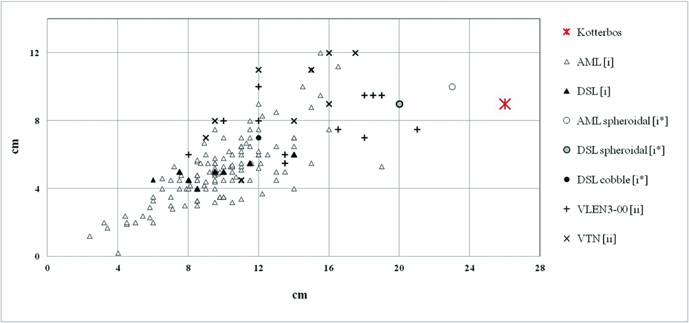
Dimensions of basalt stones from Kotterbos and the Limes in Vleuten-De Meern and Utrecht. The morphological categories ‘small’ for cuspate stones found in roads [i] and ‘intermediate’ size flattish stones found in masonry constructions [ii] are detailed in the text; note that the ‘large’ columnar blocks found in revetments [iii] fall outside the diagram. Rare stones with unusual habits found with the cuspate stones are indicated by [i*]. Acronyms refer to archaeological sites and are explained in the section on the morphologies of basalt stones from the Limes.
Basalts from Kotterbos, Vleuten-De Meern and Utrecht, and relevant basalts from the volcanic fields of the Siebengebirge (SVF) and the Vogelsberg (VVF), see Table 2, in an excision of the TAS classification. Note the outlying SiO2 content of the Vogelsberg sample #2711, as discussed in the text. Alkaline–subalkaline boundary after Irvine & Baragar (Reference Irvine and Baragar1971). Acronyms for archaeological sites are explained in the section on the macroscopic properties of basalt stones from the Limes.

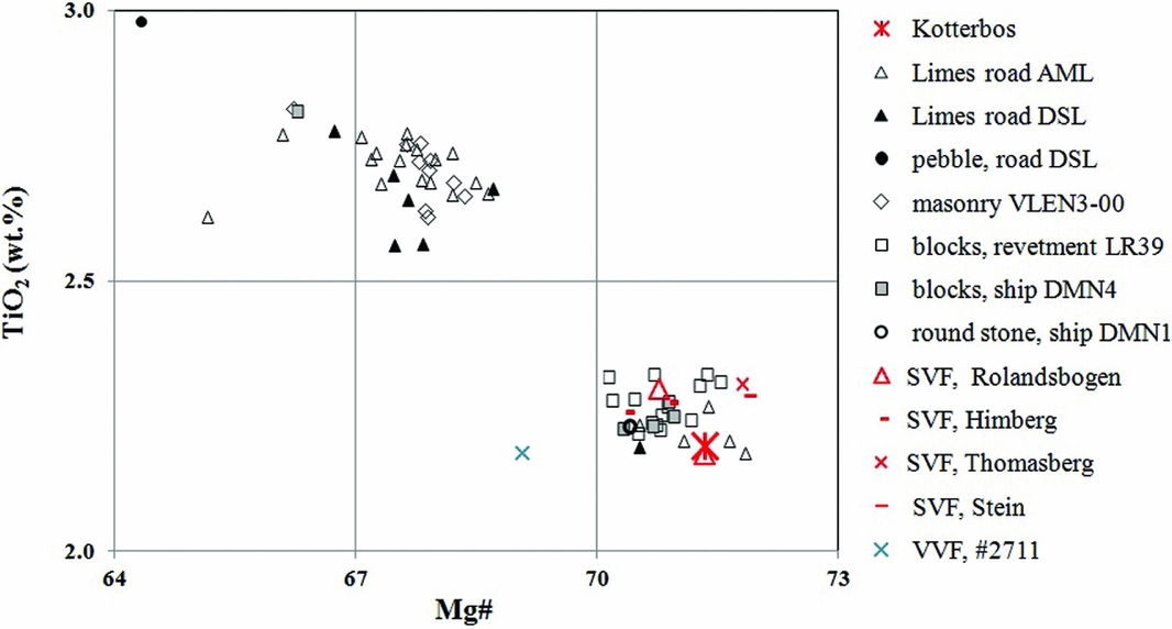
TiO2 wt% versus Mg# for the Roman basalts from Kotterbos, the Limes in Vleuten-De Meern and Utrecht, and relevant basalts from the volcanic fields of the Siebengebirge (SVF) and the Vogelsberg (VVF), see Table 2. Two large groups are apparent. The high Mg#–low TiO2 group comprises the Kotterbos basalt, a group of 25 Limes basalts and basalts from five occurrences in the Siebengebirge. Note the outlying high TiO2–low Mg# values of the well-rounded pebble of the Limes road DSL, and relatively low Mg# of VVF basalt #2711, separating it from the rest of the high Mg# group; both deviations are discussed in the text. Acronyms for archaeological sites are explained in the section on the macroscopic properties of basalt stones from the Limes.
The traverse of the Rhine through the Siebengebirge Tertiary volcanic field. Between the castellum Rigomagus (present-day Remagen) and Castra Bonnensia (Bonn), the Rhine has eroded an up to 5-km wide valley into Devonian basement and Tertiary volcanics. Fossil waterways, e.g. the Gumme, carried water in Roman times (Horn, Reference Horn and Horn1987; Gerlach, Reference Gerlach and van Rey2001) and may have played a role in the transport of basalt (Linthout et al., Reference Linthout, Paulick and Wijbrans2009). The valley is boarded by steep terraces and alluvial fans (Grunert, Reference Grunert1988). From Rigomagus downstream, the Limes coincides with the Rhine. Archaeological information concerning Roman relicts is after Horn (Reference Horn and Horn1987), Rey (Reference Rey2001) and Lendering (Reference Lendering2011). Archaeologically documented Roman activity in quarries at the sides of the Rhine is after Röder (Reference Röder1974) and Horn (Reference Horn and Horn1987). Names of locations with basalt of identical chemistry with the basalt of Kotterbos are marked by red ovals; two of these locations are outside the map area. Only Rolandsbogen complies with reasonable Roman demands from the viewpoint of military safety and logistics and is therefore accepted as the source of the Kotterbos basalt (see text). As indicated by previous geoarchaeological research by the author, the Erpeler Ley is another body that was exploited by the Romans to supply the Limes of the Netherlands with building stones.

Recently, a 3.25-kg basalt stone was reported from a Roman archaeological site about 40 km north of the Limes in the Netherlands (van Heeringen et al., Reference van Heeringen, Hessing, Kooistra, Lange, Quadflieg, Schrijvers and Weerheijm2014). The site, just outside the northern limits of Almere in the municipality of Lelystad, was discovered during a landscape redevelopment project at Kotterbos that was carried out under the commission of the Province of Flevoland and accompanied by archaeological investigations by Vestigia Archeologie & Cultuurhistorie (Amersfoort).
The single rough basalt stone and a Roman stoneware tile were the only inorganic artefacts amongst some 200 ecofacts; these latter remains comprised mainly alder stems in the prolapsed and drowned archaeological site that was buried by a gyttja, namely, a layer of debris dominated by peat moor deposited in a former lake that existed in Roman times (van Heeringen et al., Reference van Heeringen, Hessing, Kooistra, Lange, Quadflieg, Schrijvers and Weerheijm2014). Many of the stems were carved, showing for instance half-lap joints and cross-connections. Using a procedure for curve fitting (wiggle match analysis) of two triple AMS-radiocarbon dates, the felling date of one carved alder stem was refined to 69 AD (van Heeringen et al., Reference van Heeringen, Hessing, Kooistra, Lange, Quadflieg, Schrijvers and Weerheijm2014). This unusual discovery of a basalt stone at a Roman site some 40 km outside of the Limes prompted R. van Heeringen to ask the author if the Kotterbos basalt would fit in his study of Roman basalts from the Dutch Limes. More specifically, the question was whether provenance studies could determine if the stone could be attributed to one of the two established source sites for Limes basalts (i.e. Rolandsbogen or Erpeler Ley) or came from elsewhere.
To this end, the petrography and chemistry of the Kotterbos basalt have been investigated and compared with data from the author's previous studies on the subject. The results of this geoarchaeological investigation address the question of how the stone arrived at Kotterbos.
Macroscopic petrography of the Kotterbos basalt and the basalt stones from the Limes
The stone has a thin greenish grey coating due to weathering. Fresh parts show a very dark grey aphanitic matrix. As shown in Fig. 2, the finely granular surface is scattered with millimetre-sized dimples (pitting) that reflect selective erosion of abundant olivine phenocrysts. Magmatic flow has caused a somewhat wavy layering (Fig. 2a and d). Two types of xenoliths up to about 1 cm in size are mostly either olivine-rich or quartz-rich in composition.
In these aspects the Kotterbos stone is very much in line with the basalt stones found along the Limes in the Netherlands (Linthout, Reference Linthout, De Groot and Morel2007, Reference Linthout, Dielemans and van der Kamp2012, Reference Linthout and Dielemans2014; Linthout et al., Reference Linthout, Paulick and Wijbrans2009).
Morphology of the Kotterbos basalt versus morphologies of basalt stones in the Limes
The shape of the Kotterbos stone is highly irregular and planar surfaces, as can be formed in basalts by jointing during cooling, are absent. The stone is 26 cm long, raggedly tapering from a broad base (10 × 9 cm) to a pointed apex (Fig. 2). With three rough faces and one rather smooth (Fig. 2c), the stone appears to be a fragment from an exposure that was eroded in situ previously. Although the edges are somewhat worn, the stone is not rounded, suggesting that it did not undergo significant geological transport from its point of origin.
The morphological properties of the basalt stones and blocks from the Limes correlate with their functions in the respective constructions. Three groups have been distinguished previously by the author:
-
1. ‘Small’ (average 5 × 7.5 × 10 cm) angular, blocky stones with worn edges that were used in bulk, most probably as an admixture in the agger or as statumen (= foundation) of Roman roads, as in examples from the Utrecht districts Kanaleneiland (site code AML) and Hoograven (site code DSL) (Linthout, Reference Linthout, Dielemans and van der Kamp2012, Reference Linthout and Dielemans2014). It should be noted that these blocky shapes have a geological origin; they are formed by jointing during cooling in the entablure and cuspate zones of basalt bodies (Winter, Reference Winter2001). Such fragments usually accumulate in screes, where abrasion over long periods of time will eventually wear off the sharp edges to some extent. Stones of this type are by no means the result of splitting in Roman quarries or building sites, as over that geologically short period of time the edges would have preserved their original sharpness. In the two studied Roman roads, stones of morphologies other than cuspate are rare. At site AML a relatively large stone (Fig. 3) with several joint faces and one roundish face, due to spheroidal weathering, was found. A similar stone was found at site DSL. These two rocks are seen as subordinate debris in screes of the cuspate stones. Also at DSL, a smooth, ovoid cobble (7 × 8 × 12 cm) was encountered. The well-rounded character of this stone indicates significant fluvial transport and hence a relatively distant original source; this notion is corroborated by the pebble's disparate chemistry (Fig. 5). The pebble is interpreted as an accidental addition from Rhine terrace sediment to a scree of cuspate stones (Linthout, Reference Linthout, Dielemans and van der Kamp2012, Reference Linthout and Dielemans2014).
-
2. Stones of ‘intermediate’ size, 8–21 cm, with flattish outlines and occasionally featuring stains of cement, which were used as building stones in various constructions, such as a wall, a bridge, a marsh road and possibly a watchtower, all in the region of Vleuten-De Meern (site codes VLEN3–00 and VTN) (Linthout et al., Reference Linthout, Paulick and Wijbrans2009).
-
3. ‘Large’ blocks of columnar basalt, many ranging in diameter from 25 to 45 cm. These were used in large quantities in revetments and supports of embankments, for instance in the revetment at locality Balije-2, in Vleuten-De Meern (currently known as the district Leidsche Rijn in Utrecht, site code LR39). Similar blocks were found on De Meern 4, a Roman freight vessel dating from 100 AD (site code DMN4) (de Groot & Morel, Reference De Groot and Morel2007; Linthout, Reference Linthout, De Groot and Morel2007; Linthout et al., Reference Linthout, Paulick and Wijbrans2009).
One previously analysed stone is different in morphology from the stones listed above. It concerns the 10-cm large ‘round stone’ of unknown utility that was found as a solitary stone on De Meern 1, a Roman ship that was not designed for the transport of heavy cargo (Jansma & Morel, Reference Jansma and Morel2007; Mangartz, 2007). As the round stone does not show traces of working (F. Mangartz, pers. comm., 2013), it is here interpreted as an extreme product of spheroidal weathering, known as a residual boulder (Holmes, Reference Holmes1965).
Since the Kotterbos stone does not feature jointed or roundish faces, it does not conform to any of the above morphological categories. Its size is a little larger than class 2 (Fig. 3) and the wedge-like shape of the Kotterbos stone is clearly at variance with the flattish outlines of the class 2 stones. Also, the Kotterbos stone has a fundamentally different chemistry than the analysed flattish stones, as will be demonstrated in a later section of this paper (see also Fig. 5). The Kotterbos stone should therefore not be seen as an elongate fragment of a flattish building stone.
Microscopic petrography of the Kotterbos basalt and its comparison with examples from the Limes and the volcanic hinterland
The Kotterbos basalt has a porphyritic texture with scattered euhedral (1–2 mm) phenocrysts, predominantly of forsteritic olivine and subordinate Ti-augite (light-green with mauve hues). The intergranular matrix consists of very fine, crystalline Ti-augite, plagioclase, Ti-magnetite and olivine. Some brown glass occurs in isolated patches and rare vesicles are filled with analcime. Xenoliths of peridotitic and of quartz-feldspar-rich composition occur regularly; olivine, quartz and plagioclase are also found as xenocrysts, 0.5–2 mm in size. Quartz xenocrysts typically show reaction rims of fine crystalline pyroxene prisms in perpendicular orientation to the quartz matrix boundary. The rims are the result of reactions due to chemical disequilibrium between the hot basalt liquid (1000–1200°C) and the quartz crysts. Radial pyroxene aggregates without quartz are also common and these are interpreted as complete replacements of originally small quartz fragments. Judging from internal melting phenomena and corrosive embayment in their boundaries, xenocrysts of plagioclase were not initially stable in the liquid basalt either. A fresh seam of plagioclase, rimming each crystal, indicates that the mineral became stable at a later stage, most likely when the matrix plagioclase crystallised. The dominance of pyroxene, plagioclase and magnetite in the groundmass defines the rock as basalt in the broad sense. As Ti4+ in pyroxene requires Na+ for charge balance, the magma must have been alkaline. Featuring olivine not only as phenocrysts but as a matrix phase as well, the rock is alkali olivine basalt in the petrographic sense (Hughes, Reference Hughes1982; Winter, Reference Winter2001). As such, the Kotterbos basalt is similar to basalts from the Limes in Vleuten-De Meern and Utrecht (Linthout, Reference Linthout, De Groot and Morel2007, Reference Linthout, Dielemans and van der Kamp2012, Reference Linthout and Dielemans2014; Linthout et al., Reference Linthout, Paulick and Wijbrans2009) as well as to those of the CEVP (Wedepohl, et al. Reference Wedepohl, Gohn and Hartmann1994). They all are porphyritic alkali olivine basalts containing xenoliths from the mantle and the continental crust, indicating that their magmas originated in the sub-continental mantle. This notion complies with the failed rift-related intra-continental plate tectonic context of the CEVP (Wedepohl et al., Reference Wedepohl, Gohn and Hartmann1994; Jung et al., Reference Jung, Pfänder, Brauns and Maas2011). From an archaeological point of view, the CEVP is also a likely provenance area as it is near to the Netherlands. Because feldspathoids, K-rich feldspars, Mg-Fe micas (phlogopite/biotite) and amphiboles are absent from the Kotterbos and Limes basalts, these stones cannot hail from the Eifel fields, as volcanites from this region always contain one or more of those minerals (Schmincke et al., Reference Schmincke, Lorenz, Seck and Fuchs1983; Mertes & Schmincke, Reference Mertes and Schmincke1985; Huckenholz & Büchel, Reference Huckenholz and Büchel1988; Gluhak & Hofmeister, Reference Gluhak and Hofmeister2009). With the Eifel region excluded, three volcanic centres in the CEVP remain as possible areas of provenance: (i) the Siebengebirge volcanic field (SVF), (ii) the Westerwald (WVF) and (iii) the Vogelsberg (VVF). The petrographies of the alkali olivine basalts of all these fields (Vieten et al., Reference Vieten, Hamm and Grimeisen1988; Wedepohl et al., Reference Wedepohl, Gohn and Hartmann1994; Bogaard & Wörner, Reference Bogaard and Wörner2003; Haase et al., Reference Haase, Goldschmidt and Garbe-Schönberg2004; Jung et al., Reference Jung, Vieten, Romer, Mezger, Hoernes and Satir2012; Kolb et al., Reference Kolb, Paulick, Kirchenbauer and Münker2012) are similar to that of the Kotterbos basalt. Further specific information concerning the geological provenance of the Kotterbos basalt therefore cannot be obtained by microscopic petrography and the issue was investigated further using geochemical analysis.
Geochemical analysis and classification
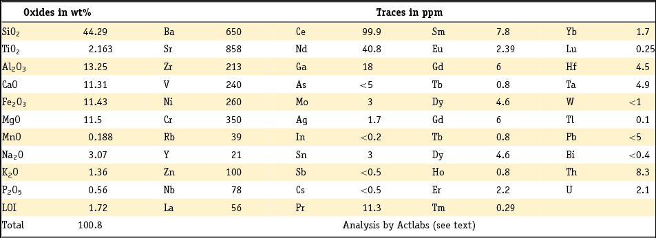
The Kotterbos basalt was analysed by Activation Laboratories Ltd Canada using lithium metaboraat/tetraboraat fusion ICP, with ICP/MS for additional trace elements. The relative precision (at 2σ) is better than 2% for major elements and better than 10% for trace elements. Table 1 gives the contents of major and minor elements and a large number of trace elements. To facilitate comparison, all plotted basalt data (Table 2) have been standardised to totals of 100 wt%, free from volatiles, and on the assumption that in basalts of this type 80% of the iron is FeO (Middlemost, Reference Middlemost1989).
Chemical analysis of the Kotterbos basalt.
Chemical data of basalts with high Mg#–low TiO2 from Roman sites in the Netherlands and of basalt bodies from the Cenozoic, CEVP; all data after normalisation to 100% dry, FeO = 80% of total iron (Middlemost, Reference Middlemost1989). Oxides are in wt%; trace elements in ppm. Blanks were not measured. The grey column shows the spreads of 23 criteria for Roman basalts from the Limes in Vleuten-De Meern and Utrecht. Data from the literature: L, Linthout Reference Linthout, De Groot and Morel2007, Reference Linthout, Dielemans and van der Kamp2012, Reference Linthout and Dielemans2014; Linthout et al., Reference Linthout, Paulick and Wijbrans2009; K, Kolb et al., Reference Kolb, Paulick, Kirchenbauer and Münker2012; V, Vieten et al., Reference Vieten, Hamm and Grimeisen1988; J, Jung et al., Reference Jung, Vieten, Romer, Mezger, Hoernes and Satir2012; B, Bogaard & Wörner, Reference Bogaard and Wörner2003. Note that the fingerprint of the Kotterbos basalt fits all criteria of the group Limes basalts. The seven basalt analyses from the CEVP, which also correlate with all (14–23) measured criteria, were traced by subjecting 390 basalt analyses from the CEVP to iterative correlation with the group's criteria.
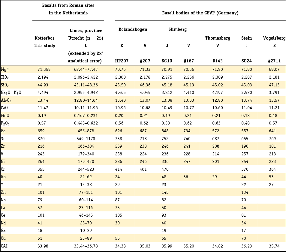
*/1x for this group and 1x for the compared analysis; errors not added for CAI
The chemical alteration index, 100*[Al2O3/(Al2O3 + CaOtotal – CaOapatite + Na2O + K2O)] (molar), CAI = 34, is below ‘incipient weathering’, which begins at CAI = 40 (Nesbitt & Young, Reference Nesbitt and Young1982). In the TAS diagram for the chemical classification of volcanic rocks (Le Maitre, Reference Le Maitre1989), advocated by the IUGS, the Kotterbos basalt plots amidst the alkali-rich dense part of the cloud of the Limes basalts from Vleuten-De Meern and Utrecht (Fig. 4). The Kotterbos stone, an alkali olivine basalt in the petrographic sense, is specified in TAS as a basanite. It is not a tephrite due to a high olivine content (ol > 10%) and absence of feldspathoid.
Studies of the origin and development of basalt magmas often make use of the Mg number, Mg# = 100*MgO/(MgO + FeO) (molar). Here, the Mg#, in combination with the TiO2 content, is used to compare the Kotterbos basalt with the Roman basalts from the Limes in Vleuten-De Meern and Utrecht, and basalts of the presumed areas of provenance. The 60 Roman basalts, from seven different excavations along the Limes, define two groups in the TiO2 wt%–Mg# space, one with high Mg# value combined with low TiO2 wt% and the other with lower Mg# and higher TiO2 wt% (Linthout, Reference Linthout, De Groot and Morel2007, Reference Linthout, Dielemans and van der Kamp2012, Reference Linthout and Dielemans2014; Linthout et al., Reference Linthout, Paulick and Wijbrans2009). Fig. 5 shows that the Kotterbos basalt (Mg# = 71.4; TiO2 = 2.2 wt%) joins in the high Mg#–low TiO2 group of 25 analyses, comprising stones from LR39 (13), DMN4 (5), AML (5), DSL (1) and DMN1 (1).
It should be noted that the masonry stones from site VLEN3–00, some of which are about the size of the Kotterbos stone (Fig. 3), are quite different in chemistry as they combine relatively low Mg# values with relatively high TiO2 content (Fig. 5).
Geochemical fingerprinting and correlation
The compositional variability of the basalts in the Tertiary volcanic fields SVF, WVF and VVF has been recorded in hundreds of whole-rock analyses (Vieten et al., Reference Vieten, Hamm and Grimeisen1988; Bogaard & Wörner, Reference Bogaard and Wörner2003; Haase et al., Reference Haase, Goldschmidt and Garbe-Schönberg2004; Linthout et al., Reference Linthout, Paulick and Wijbrans2009; Jung et al., Reference Jung, Vieten, Romer, Mezger, Hoernes and Satir2012; Kolb et al., Reference Kolb, Paulick, Kirchenbauer and Münker2012). The search for possible geological sources of the Kotterbos basalt has therefore focused on trying to find chemical compositions in this dataset that match with the chemical fingerprint of this particular stone. In this study, the fingerprint comprises 23 variables based on the contents of 25 elements: Mg and Fe (processed in Mg#), Na and K (processed in total alkali), the other major and minor elements Si, Al, Ca, Ti, P, Mn, and the trace elements Ba, Sr, Zr, V, Ni, Rb, Cr, Y, Zn, Nb, La, Ce, Nd, Cu and Ga. A basalt analysis from the CEVP would be accepted as a match for the basalt of Kotterbos if the former was within the fingerprint of the latter, inclusive of twice the appropriate analytical errors for each criterion (i.e. once for the CEVP rock and once for the analysis of the Roman basalt). Matches were sought by subjecting 390 basalt analyses from the literature to iterative correlation; 254 analyses were from SVF, 36 from WVF and 100 from VVF. As a considerable number of German basalts have not been analysed for some of the trace elements described above, full matches that were based on fewer than 23 criteria have also been evaluated.
Unfortunately, a full match with the basalt of Kotterbos could not be found. However, this is acceptable because with 13–23 variables the chance of a perfect correlation with another single sample is small. On the other hand, the nominal analytical data of the 23 items in the fingerprint of the Kotterbos basalt all are within the spreads of each of the 23 fingerprint criteria of the high Mg#–low TiO2 group of 25 Limes basalts (Table 2). This indicates that the chemical affinity of the Kotterbos basalt extends beyond the high Mg#–low TiO2 criterion. Indeed, this almost-perfect multi-component affinity justifies the proposition that the geological origin of the Kotterbos basalt can be found amongst those CEVP basalt analyses that comply with all analysed compositional criteria within the respective spreads of each of the 13–23 fingerprint criteria of the group of high Mg#–low TiO2 basalts.
Geological matches for the high Mg#–low TiO2 group
Matching by iterative exclusion, executed on 390 basalt analyses from the three CEVP fields, has resulted in seven geological matches in four different locations in the SVF and one in the VVF (Table 2). However, the latter match is questionable because the analysis of #2711 seems to have benefitted excessively from the generous allocation of analytical error margins for some of the major elements. For example, the relatively high SiO2 content (47.13 wt%) and low Mg# (69.07) plot markedly outside the respective clusters of the high Mg#–low TiO2 group in the TAS and Mg# vs TiO2 diagrams (Figs 4 and 5). The authors of the original geochemical study of this sample (Bogaard &Wörner, Reference Bogaard and Wörner2003) also indicate that it is unlikely that basalt #2711 was sampled from a former Roman quarry as most basaltic rocks in the Vogelsberg are badly altered and the very few known fresh basanites are from small plugs that are not suitable for quarrying (Wörner, pers. comm., 2007).
Archaeological significance of the geological matches
It seems reasonable to accept that the Romans preferred to quarry their stones from pits in militarily safe and logistically convenient locations, i.e. on the Roman-occupied side of the Limes and close to a waterway for transport, in this case the river Rhine. Conveniently, large basalt bodies are situated along the Rhine (Fig. 6). From an archaeological point of view, the geological matches from Himberg, Thomasberg and Stein should therefore be seriously questioned as viable locations of provenance. Despite the soundness of the chemical matches of these basalts (Table 2), their positions on higher fluvial terraces, between 6 and 21 km from the Rhine and well outside the Limes (Fig. 6), seem to be militarily vulnerable and highly unfavourable for Roman quarrying from the logistical viewpoint.
The two remaining full matches, samples HP207 and #207 (Table 2), are from the basalt body of Rolandsbogen. Situated on the west bank of the Rhine, inside the Limes and between the nearby castella (fortresses) of Bonna and Rigomagus, Rolandsbogen was well protected militarily (Fig. 6). Moreover, lying in the leeside of an island, it is in an optimal position logistically, ideal for handling bulk shipments of basalt. The many large columnar basalt blocks in revetment LR39 and onboard the Roman river cargo vessel DMN4 (Jansma & Morel, Reference Jansma and Morel2007), as well as the multitude of cuspate stones from the Limes road (Linthout, Reference Linthout, De Groot and Morel2007, Reference Linthout, Dielemans and van der Kamp2012, Reference Linthout and Dielemans2014; Linthout et al., Reference Linthout, Paulick and Wijbrans2009), show that bulk transport of basalt from Rolandsbogen to the northern Limes did take place.
The basalt stones from Rolandsbogen in the Netherlands
The bulk of the basalt stones studied from Rolandsbogen are cuspate stones and large columnar blocks that were used in roads and revetments along the Limes in Vleuten-De Meern and Utrecht. Thus far only two Rolandsbogen stones with distinctive morphologies have been recognised: the solitary round basalt stone on the Roman vessel De Meern 1, which was not designed to transport basalt, and the loose stone of Kotterbos. As argued above on chemical grounds, the Kotterbos basalt cannot be seen as an accidental fragment of a ‘flattish’ masonry stone. Their respective archaeological settings and unusual morphologies indicate that neither of these two stones was meant to be used in Roman construction. For the Kotterbos stone this implies that it cannot be seen as a stray sample that somehow was separated from a shipment of building stones to the Limes and from there brought to its final site. If these stones were not intended for building, the question remains as to why these stones were brought from Rolandsbogen.
Rolandsbogen is situated in a sheltered position on the west bank of the Rhine behind islands and may well have been a convenient anchorage, not only for the transport ships that supplied the infrastructure of the northern Limes with basalt, but for other ships as well. It is speculated that sailors visiting this anchorage may have taken loose cobbles of Rolansbogen basalt on board for some reason of their own. The basalt stone of Kotterbos and the round stone of De Meern are possible examples of this practice.
The archaeological time setting of the arrival of basalt in the infrastructure of the Limes and at Kotterbos
Multi-disciplinary studies, coordinated by a team of archaeologists from the Department of Cultural History of the Municipality of Utrecht, have revealed that the construction of the infrastructure of the Dutch Limes started between 85 and 90 AD, initially without the use of basalt (Luksen-Ytsma, Reference Luksen-IJtsma2010; Langeveld et al., Reference Langeveld, Luksen-IJtsma and Graafstal2010; Dielemans & van der Kamp, Reference Dielemans and van der Kamp2012). As shown by dendrochronology of oak timbers from constructions with the basalt stones and blocks, this rock type was first used along the Limes in 100 AD. This took place in a project aimed at the repair and protection of the Limes road against flood inundations (Langeveld et al., Reference Langeveld, Luksen-IJtsma and Graafstal2010). Around 125 AD, basalt was used in a second repair project (Dielemans & van der Kamp, Reference Dielemans and van der Kamp2012).
As a single loose stone that was not meant to be used in Roman roads or for construction, the Kotterbos stone has no functional relationship with the alder constructions on the archaeological site. The time of arrival of the basalt stone at Kotterbos is therefore not per se linked to the age of those constructions. For now, the archaeological and Quaternary geological facts for the Kotterbos site (van Heeringen et al., Reference van Heeringen, Hessing, Kooistra, Lange, Quadflieg, Schrijvers and Weerheijm2014) do not allow a more precise dating for the time of arrival of the basalt stone than between around 60 and 100 AD. The upper time limit is stratigraphically determined by the ‘gyttja’ that overlies the archaeological site. van Heeringen et al. (Reference van Heeringen, Hessing, Kooistra, Lange, Quadflieg, Schrijvers and Weerheijm2014) argue that the collapse of the alder stem constructions, their consecutive displacement and burial by the ‘gyttja’ took place relatively shortly after 69 AD, most likely around 100 AD. A clue for the maximum age can be inferred from the stoneware tile present. There is an association between basalt stones and stoneware tiles in refractory floors, designed to allow cooking on Roman vessels, and one such example is the Woerden 7 (Blom & Vos, Reference Blom and Vos2008). Assuming that the basalt stone and tile arrived at Kotterbos together, van Heeringen et al. (Reference van Heeringen, Hessing, Kooistra, Lange, Quadflieg, Schrijvers and Weerheijm2014) suggest that this took place in Roman times and in a nautical context. Scientific analysis indicates that the stoneware tile is made from a mixture of river sand and clay in the upstream Rhine area (van Os, Reference van Os, Van Heeringen, Hessing, Kooistra, Lange, Quadflieg, Schrijvers and Weerheijm2014); certainly, Roman brickworks at Xanten (Germany) and De Holdeurn (near Nijmegen in the Netherlands) were active from 60 AD and 70 AD, respectively (van Heeringen, Reference van Heeringen, Hessing, Kooistra, Lange, Quadflieg, Schrijvers and Weerheijm2014). The basalt stone and the tile may have been left by the people who carved the alder stems in 69 AD (i.e. three decades before the Romans first used basalt stones in the infrastructure of the northern Limes). However, the arrival of the items earlier or later in the period between 60 and 100 AD cannot be excluded; a discussion of nautical transport in the areas north of the Limes during that period is given by van Heeringen et al. (Reference van Heeringen, Hessing, Kooistra, Lange, Quadflieg, Schrijvers and Weerheijm2014).
Conclusions
Based on petrography, geochemical analysis and concessions to realistic Roman demands for military safety and effective logistics, the loose basalt stone that was deposited between 60 and 100 AD at the archaeological site in Kotterbos (municipality of Lelystad, the Netherlands) is a basanite that hails from Rolandsbogen on the west bank of the Rhine, 12 km upstream from Bonn (Germany).
The Kotterbos basalt is the first and so far only basalt stone in an archaeological site of Roman age that has been found beyond the Limes in the Netherlands and at a distance of 40 km north of it, and therefore it represents a significant discovery.
Acknowledgements
I thank Robert Van Heeringen of Vestigia Archeologie & Cultuurhistorie Amersfoort for asking me to investigate the basalt of Kotterbos, which appeared to be a maverick among the Roman basalts of the Low Countries, and for providing photographs of the stone. Joas van der Laan helped with placing the Kotterbos site in its geographical setting around 100 AD (Fig. 1). The manuscript benefitted from the corrections and advice by Fraukje Brouwer and an anonymous reviewer. I am obliged to another anonymous reviewer for critical remarks regarding archaeological aspects of the research question. Corrections in my English by an anonymous colleague and the editorial help by Sjoerd Kluiving are gratefully acknowledged.


