


Introduction
Knowledge of the fauna and flora that inhabit different zones of the world can provide indications of the evolution of continental masses throughout the geological eras. In the marine environment, although many species can have a wide distribution due to their dispersal by marine currents, the main factors that influence species habitats are the temperature of the water, the depth that light reaches and the presence of food resources. Strong and constant marine current fronts are boundaries that delimit water masses with different characteristics and can constitute invisible barriers to the horizontal dispersal of species, and they also biologically characterize large marine zones (Bost et al. Reference Bost, Cotté, Bailleul, Cherel, Charrassin and Guinet2009).
The three main global oceans - the Pacific, Atlantic and Indian oceans - unite without interruption in the south, then are separated northwards around the southern tip of Africa, South America and Australia/New Zealand. This vast body of water surrounds Antarctica and has been given the name Southern Ocean (SO), which was officially accepted by the International Hydrographic Organization (IHO) in 2000 (https://doi.org/10.1594/PANGAEA.57673). However, its northern limits have not been well-defined.
Since the late nineteenth century, there have been many studies of SO biogeography, with some defining a northern limit and others establishing biogeographical zones and provinces (e.g. Ortmann Reference Ortmann1896, Hedgpeth Reference Hedgpeth1970, Knox Reference Knox2006, Longhurst Reference Longhurst2007). Briggs & Bowen (Reference Briggs and Bowen2012) suggested boundaries for SO biogeographical regions, which were later accepted and expanded by Toonen et al. (Reference Toonen, Bowen, Iacchei, Briggs and Kliman2016). These bioregions were also summarized by De Broyer & Koubbi (Reference De Broyer, Koubbi, De Broyer, Koubbi, Griffiths, Raymond, d’Udekem d'Acoz and Van de Putte2014). In the present work, we mostly adhere to the biogeographical boundaries proposed by Toonen et al. (Reference Toonen, Bowen, Iacchei, Briggs and Kliman2016) for both cold-temperate and polar SO areas. Chapman et al. (Reference Chapman, Lea, Meyer, Sallée and Hindell2020) defined and described SO marine fronts and discussed their influence on biological process. Here, we consider the SO to include all water masses south of latitude 41°S, which is the approximate latitude of the Southern Subtropical Front (SSF). The SSF is biologically important because it delimits the warmer and more saline waters located to the north from the less saline and colder waters in the south. Generally, differences between these water masses govern most marine species distributions.
The biodiversity of SO marine invertebrates has been studied by several historical and contemporary oceanographical expeditions. The results of these surveys have been documented by several workers such as De Broyer et al. (Reference De Broyer, Jazdzeska, De Broyer, Koubbi, Griffiths, Raymond, d’Udekem d'Acoz and Van de Putte2014), and the taxonomic species richness was summarized by Ballesteros et al. (Reference Ballesteros, Hopkins, Salicrú and Nimbs2025). However, many bioregionalization analyses of the SO have centred on Antarctic waters, with much still to be learned about the diversity of abyssal areas (Brandt et al. Reference Brandt, De Broyer, De Mesel, Ellingsen, Gooday, Hilbig and Tyler2007), which account for the vast majority of the spatial extent of the SO.
Taxonomic studies are essential to understanding the distribution of biota and to defining ecoregions, including oceans (Koubi et al. Reference Koubi, De Broyer, Griffiths, Raymond, d’Udekem d'Acoz, Van de Putte, De Broyer, Koubbi, Griffiths, Raymond, d’Udekem d'Acoz and Van de Putte2014). Such studies that have helped to define the biogeography of the SO based on invertebrate diversity, including bryozoans (Barnes & De Grave Reference Barnes and De Grave2000), Antarctic echinoderms (Danis et al. Reference Danis, Griffiths, Jangoux, De Broyer, Koubbi, Griffiths, Raymond, d’Udekem d'Acoz and Van de Putte2014, Eléaume et al. Reference Eléaume, Hemery, Roux, Améziane, De Broyer, Koubbi, Griffiths, Raymond, d’Udekem d'Acoz and Van de Putte2014, Saucède et al. Reference Saucède, Pierrat, David, De Broyer, Koubbi, Griffiths, Raymond, d’Udekem d'Acoz and Van de Putte2014), Amphipoda (De Broyer et al. Reference De Broyer, Lowry, Jażdżewski, Robert and De Broyer2007, De Broyer & Jazdzewska Reference De Broyer, Jazdzeska, De Broyer, Koubbi, Griffiths, Raymond, d’Udekem d'Acoz and Van de Putte2014), Antarctic and sub-Antarctic Isopoda (Kaiser Reference Kaiser, De Broyer, Koubbi, Griffiths, Raymond, d’Udekem d'Acoz and Van de Putte2014), Porifera (Downey et al. 2012, Janussen & Downey Reference Janussen, Downey, De Broyer, Koubbi, Griffiths, Raymond, d’Udekem d'Acoz and Van de Putte2014), zooplankton (McLeod et al. Reference McLeod, Hosie, Kitchener, Takahashi and Hunt2010), Antarctic and Magellan polychaeta (Montiel Reference Montiel2005, Schüller & Ebbe Reference Schüller, Ebbe, De Broyer, Koubbi, Griffiths, Raymond, d’Udekem d'Acoz and Van de Putte2014), pycnogonids (Munilla & Soler-Membrives Reference Munilla and Soler-Membrives2009), Antarctic anemones (Rodríguez et al. Reference Rodríguez, López-González and Gili2007), shelled Antarctic and sub-Antarctic molluscs (Dell Reference Dell1990, Linse et al. Reference Linse2006), heterobranch sea slugs (Ballesteros et al. Reference Ballesteros, Hopkins, Salicrú and Nimbs2025) and several others. A useful tool for the analysis of the diversity and ecology of molluscs is the Southern Ocean Mollusc Database (SOMBASE), a global database of SO molluscs (Griffiths et al. Reference Griffiths, Linse and Crame2003), and Rauschert & Arntz (Reference Rauschert and Arntz2015) is particularly useful given the large number of photographs of living specimens that this study provides.
There are few studies that explore the comparative biogeography of the SO. Primo & Vázquez (Reference Primo and Vázquez2007) analysed the biodiversity of Antarctic, sub-Antarctic and far South American ascidians, and Primo & Vázquez (Reference Primo, Vázquez, De Broyer, Koubbi, Griffiths, Raymond, d’Udekem d'Acoz and Van de Putte2014) later analysed the ascidian faunal assemblage across the entirety of the waters south of the SSF. Linse et al. (Reference Linse2006) analysed the biogeography of the Antarctic and sub-Antarctic shelled molluscs and defined three provinces in the SO. Griffiths et al. (Reference Griffiths, Barnes and Linse2009) explored the distribution of bivalves, gastropods and bryozoans across 29 regions in the Southern Hemisphere and reported that the boundaries of SO biogeographical regions may differ depending on the taxonomic group studied.
The biodiversity of one of the largest invertebrate groups, the molluscs, in the SO has been studied, in part, by several authors. For example, Powell described molluscs from the Antarctic and sub-Antarctic (Powell Reference Powell1951, Reference Powell1958, Reference Powell1960) and from Kerguelen and Macquarie islands (Powell Reference Powell1957), Carcelles (Reference Carcelles1953) prepared an early inventory of Antarctic molluscs from the Argentine area, Linse (Reference Linse1999) and Forcelli (Reference Forcelli2000) studied Magellanic molluscs, Aldea & Troncoso (Reference Aldea and Troncoso2008, Reference Aldea and Troncoso2010) studied species from the South Shetland Islands and the Bellinghausen Sea; Engl (Reference Engl2012) described Antarctic shelled molluscs in his impressive work, Grove (Reference Grove2015, Reference Grove2018) published a guide to the marine molluscs of Tasmania and an early work by May (Reference May1921) provided a list of the molluscs of the same island. Spencer et al. (Reference Spencer, Willan, Marshall and Murray2016) compiled a catalogue of New Zealand marine molluscs, and García & Bertsch (Reference García and Bertsch2009) carried out an interesting biogeographical study on the diversity and distribution of sea slugs from the Atlantic Ocean.
Sea slugs (Mollusca, Gastropoda, Heterobranchia, formerly Opisthobranchia) of the SO have been studied since the nineteenth century. Prominent researchers who studied sea slug samples collected by the early expeditions include Bergh (Reference Bergh1884), Pelseneer (Reference Pelseneer1903), Eliot (Reference Eliot1905, Reference Eliot1907a, Reference Eliot1907b, Reference Eliot1909), Vayssière (Reference Vayssière1906), Odhner (Reference Odhner1926, Reference Odhner1934) and Marcus (Reference Marcus1959). Later, among others, Minichev (Reference Minichev1972) studied the remote coasts of the Davis Sea (East Antarctica), Vicente (Reference Vicente1974) studied the nudibranchs of the Kerguelen Islands, Vicente & Arnaud (Reference Vicente and Arnaud1974) studied species from Adélie Land, Cattaneo-Vietti (Reference Cattaneo-Vietti1991) examined the nudibranchs of the Ross Sea, Castellanos et al. (Reference Castellanos, Landoni and Dadon1993) studied the sea slugs of the Magellanic zone and Schrödl (Reference Schrödl2003) examined the nudibranchs and pleurobranchs of the Magellanic zone. The pelagic Pteropoda were studied by Hunt et al. (Reference Hunt, Pakhomov, Hosie, Siegel, Ward and Bernard2008). Ballesteros et al. (Reference Ballesteros, Hopkins, Salicrú and Nimbs2025) recorded a total of 395 species of sea slugs for the SO south of 41°S, of which 40 were Pteropoda.
Until just a few decades ago, sea slug species identification was based on morphological identification. Molecular biology has since enabled the identification of new species and cryptic species complexes of sea slugs, expanding their known biodiversity. This work also includes new species described in recent studies based on molecular analysis. The aim of the present work is to provide a biogeographical analysis of SO sea slugs, comparing species richness across various bioregions, with the aim of exploring and discussing their geographical affinities.
Materials and methods
Geographical bioregions
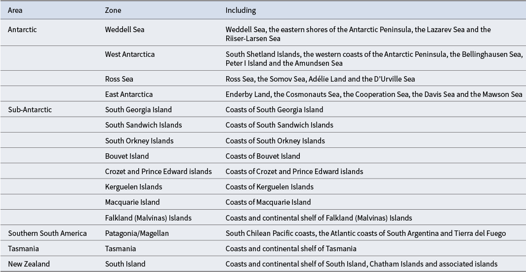
For the biogeographical analyses, the following regions (Fig. 1 & Table I) have been used, all of them south of the 41°S parallel: South Island, New Zealand; Tasmania, Australia; Crozet and Prince Edward islands; Kerguelen Islands; Macquarie Island; Patagonia/Magellan, South America; Falkland (Malvinas) Islands; South Georgia Island; South Sandwich Islands; South Orkney Islands; Bouvet Island; and Antarctica (Weddell Sea, West Antarctica, Ross Sea, East Antarctica). Powell (Reference Powell1960) comprehensively discussed the physical characteristics of each of these regions and their biogeographical relationships.
Biogeographical areas and Antarctic marine zones. Antarctic: EA = East Antarctica; RS = Ross Sea; WA = West Antarctica; WS = Weddel Sea. Patagonia/Magellanic = PAT/MAG; Sub-Antarctic: BOU = Bouvet Island; FAL = Falkland (Malvinas) Island; KER = Kerguelen Islands; MACQ = Macquarie Island; PEC = Prince Edward and Crozet islands; SG = South Georgia Island; SO = South Orkney Islands; SS = South Sandwich Islands. Tasmania = TAS; New Zealand: NZ = South Island of New Zealand. Antarctic marine zones: 1 = Weddell Sea; 2 = Bellingshausen Sea; 3 = Amundsen Sea; 4 = Ross Sea; 5 = Somov Sea; 6 = D’Urville Sea; 7 = Mawson Sea; 8 = Davis Sea; 9 = Cooperation Sea; 10 = Cosmonauts Sea; 11 = Riiser-Larsen Sea; 12 = Lazarev Sea.

Biogeographical regions used for the analyses in this research.

Data collection
The data used in the present study were collected from the records of 158 published works on Antarctica, the sub-Antarctic region, South America, Tasmania and southern New Zealand: Weddell Sea, 12 works; West Antarctica, 18 works; Ross Sea, 22 works; East Antarctica, 8 works; South Georgia Island, 13 works; South Sandwich Islands, 1 work; South Orkney Islands, 9 works; Bouvet Island, 3 works; Crozet and Prince Edwards islands, 2 works; Kerguelen Islands, 8 works; Macquarie Island, 2 works; Falkland Islands, 5 works; Patagonia/Magellan, 26 works; Tasmania, 15 works; South Island of New Zealand, 14 works. The data used are also from the authors’ unpublished records from the Antarctic area.
A substantial bibliography of scientific papers was collected and analysed for reports and information on any heterobranch sea slugs species in the study areas and zones. In addition to the pioneer publications mentioned in the ‘Introduction’ section, many others were analysed, and these are listed in Table II.
List of publications consulted in alphabetical order of authors and those of the same first author in chronological order.

The databases of sea slug species records from the ECOQUIM I expedition conducted onboard the RV Polarstern (2003–2004) in the Weddell Sea and the ECOQUIM II expedition conducted on board the BIO Hespérides (2006) off the coast of the South Shetland Islands have also been used (MB participated in both expeditions). The authors have verified that the data used in the present study also include all sea slug species recorded in the web portals Scientific Committee on Antarctic Research - Marine Biodiversity Information Network (SCAR-MarBIN; https://www.vliz.be/projects/scarmarbin/index.php), SOMBASE (https://www.gbif.org/occurrence/2270439982), the Australian Antarctic Data Centre (https://data.aad.gov.au/aadc/biodiversity) and the Global Biodiversity Information Facility (GBIF; https://www.gbif.org).
Statistical analysis
A total of 355 benthic species were listed in a presence/absence table for each bioregion (Table S1). As additional information, this table also includes 40 species of pteropods that have been recorded in oceanographic surveys in different areas of the SO; these species have not been included in the statistical analyses due to their pelagic life and wide geographical distribution in numerous marine areas. Bioregional similarities were analysed using the Sorensen index, calculated as follows:
 $$\begin{align*}{s}_{Sorensen}\left({Z}_i,{Z}_j\right) = \frac{2{a}_{ij}}{2{a}_{ij}+{b}_{ij}+{c}_{ij}} \end{align*}$$
and dissimilarities were calculated as follows:
 $$\begin{align*}{d}_{Sorensen}\left({Z}_i,{Z}_j\right) = 1-\frac{2{a}_{ij}}{2{a}_{ij}+{b}_{ij}+{c}_{ij}} = \frac{b_{ij}+{c}_{ij}}{2{a}_{ij}+{b}_{ij}+{c}_{ij}} \end{align*}$$
where aij is the number of species observed in the two zones (Zi and Zj ) and bij and cij represent the numbers of species observed in a single zone (bij : number of species observed in Zi and not observed in Zj ; cij : number of species not observed in Zi and observed in Zj ). The K-mean method has been used to classify the zones by affinity. This method guarantees that the variability within the groups is minimal. The proposed number of groups (g = 5) is consistent with the quantitative information provided by the ΔTESS, pseudo-F and silhouette statistics. At g = 5 all three statistics are maximized when considering the sweep at g = 1, g = 2, …, g = 6 (ΔTESS: 18.88 for g = 2, 20.02 for g = 3, 17.73 for g = 4, 20.94 for g = 5 and 18.33 for g = 6; pseudo-F: 3.3060 for g = 2, 3.4090 for g = 3, 3.2970 for g = 4, 3.5050 for g = 5 and 3.4940 for g = 6; silhouette: 0.1516 for g = 2, 0.1681 for g = 3, 0.2053 for g = 4, 0.2931 for g = 5 and 0.2672 for g = 6). Bioregions were visualized using multi-dimensional scaling (MDS). The Kruskal stress (4.57% in 2D) demonstrates the reliability of the representation. In order to recognize the characteristics and differences between the groups, the most representative and distinctive species of each group have been identified.
With small sample sizes in some zones (n = 1 publication, South Sandwich Islands; n = 2 publications, Prince Edward and Crozet islands; n = 2 publications, Macquarie Island; and n = 3 publications, Bouvet Island) and different levels of representativeness in the samples, the coherence of the groupings obtained by applying the Sorensen and Simpson indices with the K-mean method (s Simpson(Zi ,Zj ) = aij / (aij + min{bij ,cij }) has been verified. In addition, the concordance between the non-hierarchical classification (K-mean) and the hierarchical classification obtained using the WARD and UPGMA methods has been verified.
Results
Biogeographical affinities
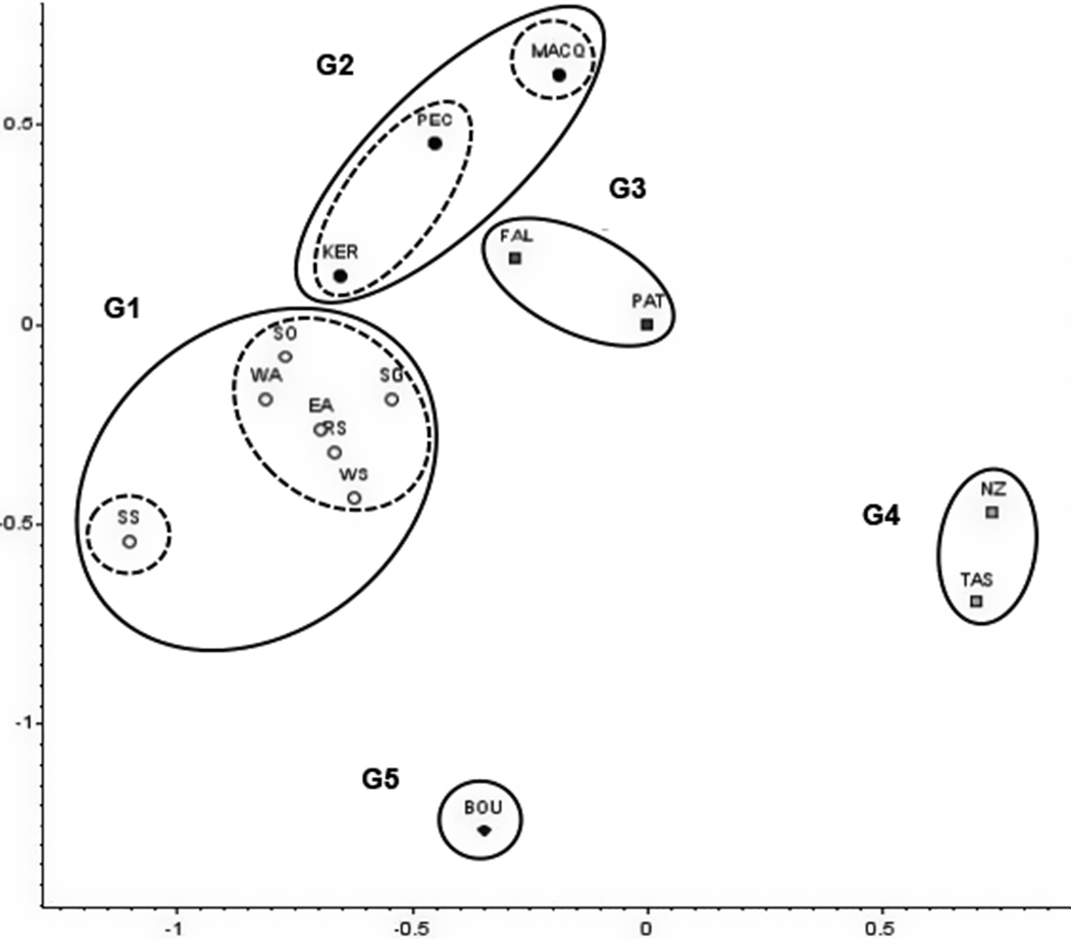
The classification into 5 groups (g = 5) has provided the following partition (zones assigned to each group; Fig. 2):
-
G1 = {Weddell Sea (WS), West Antarctica (WA), Ross Sea (RS), East Antarctica (EA), South Georgia Island (SG), South Sandwich Islands (SS), South Orkney Islands (SO)}
-
G2 = {Prince Edward and Crozet islands (PEC), Kerguelen Islands (KER), Macquarie Island (MACQ)}
-
G3 = {Falkland Islands (FAL), Patagonian and Magellanic zone (PAT/MAG)}
-
G4 = {Tasmania (TAS), South Island of New Zealand (NZ)}
-
G5 = {Bouvet Island (BOU)}
Geometrical representation of the zones and groupings from the southern seas: Weddell Sea (WS), West Antarctica (WA), Ross Sea (RS), East Antarctica (EA), South Georgia Island (SG), South Sandwich Islands (SS), South Orkney Islands (SO), Prince Edward and Crozet islands (PEC), Kerguelen Islands (KER), Macquarie Island (MACQ), Falkland Islands (FAL), Patagonian and Magellanic zone (PAT/MAG), Tasmania (TAS), South Island of New Zealand (NZ) and Bouvet Island (BOU). The solid lines delimit the five groups, and the dashed lines within G1 and G2 indicate the real or artificial isolation of the zones represented by small samples.

The G1 group is made up of all of the zones that are located within the Polar Front (the four Antarctic ones (WS, WA, RS, EA) and three sub-Antarctic zones (SG, SS, SW)), except BOU, which is isolated in the G5 group. The G1 group has remained stable at all classification levels (g = 2, g = 3, g = 4 and g = 5), and the G5 group has been separated from the others starting at level g = 4. The G2 group is made up of the rest of the sub-Antarctic zones (PEC, KER, MACQ), except FAL, which has been joined with PAT/MAG to form the G3 group. The common characteristics explain why the two groups have remained united at levels g = 2 and g = 3 and are observed separately at levels g = 4 and g = 5. The union of the zones that form the G3 group is very stable, easily overcoming the differences in representativeness of the samples. The G4 group is made up of the two zones of the oceanic continent (TAS, NZ). The union of the zones that form the G4 group is also very stable, and the sample sizes are also relevant. The effect attributable to the small sample sizes has been revealed when the classification into seven groups has been considered. At this level of classification, the structure in five groups is maintained and the zones with small sample sizes are isolated: SS (n = 1), MACQ (n = 2) and BOU (n = 3). This distribution of groups has also been revealed in the MDS representation. The map in Fig. 3 shows the five groups of biogeographical affinities obtained.
Geographical map showing the areas and zones grouped into the five groups (G1–G5) of biogeographical affinities obtained. Abbreviations and numbering: ACC = Antarctic Circumpolar Current; EA = East Antarctica; RS = Ross Sea; WA = West Antarctica; WS = Weddell Sea; 1 = Patagonia/Magellan; 2 = Falkland (Malvinas) Islands; 3 = South Georgia Island; 4 = South Orkney Islands; 5 = South Sandwich Islands; 6 = Bouvet Island; 7 = Prince Edward and Crozet islands; 8 = Kerguelen Islands; 9 = Macquarie Island; 10 = Tasmania; 11 = South Island of New Zealand; 12 = Amundsen Sea; 13 = Bellingshausen Sea; 14 = South Shetland Islands; 15 = Lazarev Sea; 16 = Riiser-Larsen Sea; 17 = Cosmonauts Sea; 18 = Cooperation Sea; 19 = Davis Sea; 20 = Mawson Sea; 21 = D’Urville Sea; 22 = Somov Sea.

Representative and distinctive species of the groups
Eighty-two species have been observed in the zones of group G1. The 17 most representative species (present in more than 50% of the zones of the group) and most distinctive from the other zones (present in less than 50% of the complementary zones) are: Acteon antarcticus (present in all zones of group G1 and in one zone of group G2); Newnesia antarctica, Notaeolidia gigas and Bathyberthella antarctica (with unique presence in six zones of group G1); Toledonia major and Bathydoris hodgsoni (with unique presence in five zones of group G1); Myrella challengeriana and Tritoniella belli (present in six zones of group G1 and in the zones of group G3); Antarctophiline alata (present in six zones of group G1 and in the zones of groups G2 and G3); Prodoris clavigera (occurring in five zones of group G1 and one zone of group G3); Antarctophiline gibba, Notaeolidia depressa, Pseudotritonia gracilidens and Pseudotritonia quadrangularis (with unique occurrence in four zones of group G1); Toledonia elata (occurring in all four Antarctic zones of group G1 and in two zones of group G2); Cuthona crinita (occurring in four zones of group G1 and on Bouvet Island (G5)); and Diaphana paessleri (occurring in four zones of group G1 and in the zones of groups G2 and G3). With lesser representation and great distinctiveness, the unique occurrence in three zones of group G1 has been observed in the following species: Cylichna gelida, Toledonia globosa, Aegires albus, Pseudotritonia antarctica, Eubranchus glacialis, Notaeolidia schmekelae, Tergipes antarcticus and Curnon granulosa. Taxonomically, the species observed in group G1 are included in four taxonomic groups: Nudibranchia, Cephalaspidea, Acteonimorpha and Pleurobranchida.
Eighteen species have been observed in the zones of group G2. The only representative species of the group are: Doris kerguelenensis (occurring in three zones of group G2, six zones of group G1 and two zones of group G3); Toledonia elata (occurring in two zones of group G2 and four zones of group G1); and Diaphana paessleri (occurring in two zones of group G2, four zones of group G1 and two zones of group G3). Seven species have been observed in only one zone of group G2: on Kerguelen Islands: Toledonia circumrosa, Toledonia media, Cadlina kerguelensis, Eubranchus arnaudi and Guyvalvoria savinki; and on Macquarie Island: Cuthona macquariensis and Trinchesia macquariensis. Taxonomically, the species observed in group G2 are included in three taxonomic groups: Nudibranchia, Cephalaspidea and Acteonimorpha.
Sixty-eight species have been observed in the zones of group G3. The most representative and distinctive species are: Toledonia biplicata, Toledonia bullata, Antarctophiline flaklandica, Aeolidia campbelli, Cadlina magellanica, Diaulula punctuolata, Gargamella immaculata, Geitodoris patagónica, Acanthodoris falklandica, Cuthona valentini and Berthella platei. These species are characterized by their presence in both zones of the group and by their absence from the zones of the other groups. Thirty-six more species have been observed only in the zones of group G3: in the Falkland Islands: Parvaplustrum tenerum, Doris falklandica, Eubranchus falklandicus and Tritoniella gnocchi; and in the Patagonian/Magellanic zone: Praephiline thurmanni, Scaphander interruptus, Acteon fasuloi, Lanayrella ringei, Lanayrella vagabunda, Berghia rissodominguezi, Spurilla braziliana, Cadlina sparsa, Tyrinna delicata, Corambe lucea Doris claurina, Doris fontainei, Doris plumulata, Diaulula hispida, Dialula variolata, Rostanga pulchra, Doto uva, Eubranchus fugiensis, Phidiana lottini, Phidiana patagonica, Ancula fuegiensis, Bermudella angelensis, Holoplocamus papposus, Polycera marplatensis, Polycera priva, Thecacera darwini, Cuthona odhneri, Tritonia odhneri, Ercolania evelinae, Aplysiopsis brattstroemi, Elysia cf. hedgpethi and Elysia patagonica. Eight species occur together in the zones of groups G1, G2 and G3, 10 additional species occur together in the zones of groups G1 and G3, no additional species occur only in the zones of groups G2 and G3, three species occur together in the zones of groups G3 and G4 and no species occur together in groups G3 and G5. Taxonomically, the species observed in group G3 are included in five taxonomic groups: Nudibranchia, Cephalaspidea, Acteonimorpha, Pleurobranchida and Sacoglossa.
Two hundred and ten species have been observed in the zones of group G4 (Tasmania and the South Island of New Zealand). The 30 most representative and most distinctive species are: Philinopsis gigliolii, Bulla quoyii, Diaphana brazieri, Diaphana tasmanica, Philine angasi, Philine auriformis, Bullina lineata, Aeolidiella drusilla, Baeolidia australis, Baeolidia macleayi, Heterodoris antipodes, Cadlina tasmanica, Ceratosoma amoenum, Dendrodoris maugeana, Dendrodoris nigra, Doris wellingtonensis, Hoplodoris nodulosa, Doto pita, Eubranchus rubeolus, Fiona pinnata, Glaucilla atlanticus, Bermudella mija, Tambja verconis, Berthella medietas, Placida dendrítica, Oxynoe viridis, Aplysia argus, Aplysia concava, Aplysia extraordinaria and Aplysia juliana. These species are characterized by their presence in the two zones of the group and by their absence from the zones of the other groups. One hundred and seventy-nine species have been observed only in one zone of group G4, three species occur together in the zones of groups G3 and G4 and one species occurs together in the zones of groups G1 and G4. Taxonomically, the species observed in group G4 are included in nine taxonomic groups: Nudibranchia, Cephalaspidea, Acteonimorpha, Sacoglossa, Ringiculimorpha, Pleurobranchida, Umbraculida, Runcinacea and Aplysiida.
Four species have been observed in group G5 (Bouvet Island). Myrella dantarti has been observed only in Bouvet Island, and Cuthona crinita, Doto antarctica and Diaphana inflata have also been observed in the zones of group G1. Taxonomically, the species observed in group G4 are included in two taxonomic groups: Nudibranchia and Cephalaspidea.
Compatibility with other numerical treatments
The clusters obtained by applying the K-mean method are compatible with those obtained by applying hierarchical methods (Fig. 4). In both cases, the classification is maintained at g = 5 (Fig. 4), and at g = 7 using the WARD method, the populations represented with small sample sizes are isolated (SS, MACQ and BOU). Using the Simpson index, each statistic indicates a different number of groups (ΔTESS, g = 3; pseudo-F, g = 6; silhouette, g = 2 and g = 5) and, consequently, the optimal number cannot be inferred. Maintaining the central structure, the supposed symmetry in the non-concordances conditions the classification at high levels (b ≈ c using the Simpson index). Specifically, for g = 3, all of the zones within the Polar Front are grouped into a single block (BOU is separated later), the rest of the sub-Antarctic zones and South America are grouped into a second block and the zones of the oceanic continent are grouped into a third block. From g = 3 onwards, the differences in detail are distorted by the supposed symmetry contradicted by the observations in the zones with larger sample sizes.
Hierarchical classification of the zones from the southern seas (Sorensen distance): a. WARD method and b. UPGMA method. The solid red lines separate the five groups, and the dashed lines show the real or artificial isolation of the zones represented by small samples. TAS = Tasmania; NZ = South Island of New Zealand; BOU = Bouvet Island; PEC = Prince Edward and Crozet islands; KER = Kerguelen Islands; MACQ = Macquarie Island; FAL = Falkland Islands; PAT = Patagonia/Magellan; WS = Weddell Sea; RS = Ross Sea; EA = East Antarctica; WA = West Antarctica; SO = South Orkney Islands; SG: South Georgia Island; SS = South Sandwich Islands.

Discussion and conclusions
As some authors (e.g. Koubi et al. Reference Koubi, De Broyer, Griffiths, Raymond, d’Udekem d'Acoz, Van de Putte, De Broyer, Koubbi, Griffiths, Raymond, d’Udekem d'Acoz and Van de Putte2014) pointed out, taxonomy is a fundamental component when studying biogeography and for establishing biogeographical affinities between different zones, both terrestrial and marine. On a large scale, the depth, marine currents, typology (soft or rocky substrates) and geomorphology of the ocean floor (flat or inclined substrates, canyons, seamounts, etc.) determine the presence of species in the benthos; we must also take into account that different taxonomic groups may have different geographical distribution patterns (Brandt et al. Reference Brandt, De Broyer, De Mesel, Ellingsen, Gooday, Hilbig and Tyler2007). In addition, on a smaller scale, some of the factors that can influence benthic animal species are the orientation and inclination of the rocky substrate, the presence of algal species for herbivorous animals or the existence of suspended particulate matter for filter-feeders. Recently, Ballesteros et al. (Reference Ballesteros, Hopkins, Salicrú and Nimbs2025) provided very interesting data on the biodiversity and taxonomy of sea slugs from different regions of the SO that have allowed us to establish in this paper the biogeographical affinities of this group of molluscs in that wide marine area.
In addition, Koubi et al. (Reference Koubi, De Broyer, Griffiths, Raymond, d’Udekem d'Acoz, Van de Putte, De Broyer, Koubbi, Griffiths, Raymond, d’Udekem d'Acoz and Van de Putte2014), as a summary of the different works on the taxonomic groups that appear in the vast work of De Broyer et al. (Reference De Broyer, Jazdzeska, De Broyer, Koubbi, Griffiths, Raymond, d’Udekem d'Acoz and Van de Putte2014) on the biogeography of the SO, define seven different biogeographical regions, and our results are in agreement with the main biogeographical models of previous authors, considering as transitional zones the Weddell Sea and the Amundsen Sea between East Antarctica and West Antarctica and the Falkland Islands between the Magellanic region and the sub-Antarctic islands of the Scotia Arc.
Griffiths et al. (Reference Griffiths, Barnes and Linse2009) studied the biogeographical affinities of 29 regions in the SO, including those that appear in our study, but also adding the southernmost region of Africa and the island of Tristan da Cunha. These authors constructed a table indicating the species present in each of these regions according to the groups of Bryozoa (Cyclostomata and Cheilostomata), Bivalvia and shelled Gastropoda molluscs, and they considered that their studied regions, according to statistical analysis, can be categorized into three groups: South America, Antarctica and New Zealand, which would correspond to our groups G3, G1 and G4, respectively, and are the most important in terms of the number of recorded species. Regarding shelled gastropods, Griffiths et al. (Reference Griffiths, Barnes and Linse2009) found that species from sub-Antarctic islands (especially those from the Falkland Islands and the Scotia Arc) have more affinities with those from Antarctica than with those from South America, as is also the case in our work with the sea slug heterobranch gastropods, except for the species from the Falkland Islands, which in our analysis are related to those from the southern cone of America rather than those from the sub-Antarctic zones.
In keeping with the basic ecological tenet of a concomitant reduction in biodiversity with increasing proximity to the poles (Gaston Reference Gaston2000), it is unsurprising that G4 (Tasmania and the South Island of New Zealand) supports the highest levels of taxonomic diversity and species endemism in the SO (Ballesteros et al. Reference Ballesteros, Hopkins, Salicrú and Nimbs2025). Given that sea slugs sensu lato are a fundamentally tropical group (Rudman & Willan Reference Rudman, Willan, Beesley, Ross and Wells1998), their diversity in Tasmania and New Zealand is reflective of historical and contemporary connectivity to warmer waters. In eastern Australia, there are ~1000 sea slug species in its tropical waters, which reduces to ~250 species in Bass Strait (northern edge of the SO) and then to ~150 species in southern Tasmania. In the Australian SO territories (Macquarie and Heard islands), this diversity reduces even further, to ~50 taxa (Rudman & Willan Reference Rudman, Willan, Beesley, Ross and Wells1998). Patterns of diversity in New Zealand follow the same attenuation with increasing latitude (Willan & Morton Reference Willan and Morton1984). Although Australia and New Zealand share some species, diversity at similar latitudes in New Zealand is lower, most likely driven by its significant spatiotemporal isolation (Willan & Morton Reference Willan and Morton1984). Connectivity between the two land masses via Tasman Sea currents means that the faunal affinity between the two locations is ~14% (n = 30) of recorded species. Due to spatiotemporal isolation, group G4 has comparatively high levels of endemism compared to the other SO groups, sharing only four taxa with the other SO bioregions. Unsurprisingly, these shared species are planktonic, as the agents of dispersal and distribution among planktonic nudibranchs are vastly different from those that drive patterns in benthic groups (Rudman & Willan Reference Rudman, Willan, Beesley, Ross and Wells1998). Indeed, many planktonic taxa have a near-circumpolar distribution.
Historically, Tasmania was part of the Australian mainland, but about 10,000 years ago, at the end of the Last Glacial Maximum, a significant rise in sea level (Lewis et al. Reference Lewis, Sloss, Murray-Wallace, Woodroffe and Smithers2013) formed the Bass Strait, which is ~240–300 km wide, has a maximum depth of ~50 m, and is interspersed with islands that represent emergent, elevated areas of the flooded continental shelf (Williams et al. Reference Williams, Ulm, Sapienza, Lewis and Turney2018). Currents flowing east from the Indian Ocean and west from the south-western Pacific Ocean converge here and can deliver larvae of some warm-temperate species into the cooler waters of Tasmania (Dickman Reference Dickman2018). As a result, the Tasmanian fauna contains a larger proportion of warm water-associated groups than any of the other SO regions. For example, there are some 20 species of the tropically affiliated nudibranch family Chromodoridiae in Tasmania. Proximity to and the movement of warm waters from the tropical Indo-West Pacific have resulted in the evolution of extant regional endemics in Tasmania and the South Island of New Zealand that are akin to their tropical ancestors (some warm water conspecific vagrants are still occasionally found in these regions (Rudman & Willan Reference Rudman, Willan, Beesley, Ross and Wells1998)) rather than those of the polar regions.
Some characteristics of the waters surrounding Tasmania are very different from the rest of Australia; for example, salinity is relatively low (~34 parts per thousand) and is closer to the salinity of Antarctic waters (which is also ~34 parts per thousand); the temperature of the water surrounding Tasmania is also lower, ranging on average between 10°C and 11°C in the winter (August) and between 17°C and 18°C in the summer (January) (Rotschi & Lemasson Reference Rotschi and Lemasson1967, SeaTemperature.info 2025). The island of Tasmania along with the South Island of New Zealand, the southern tip of South America and the sub-Antarctic islands are considered by Briggs & Bowen (Reference Briggs and Bowen2012) to be within the cold-temperate regions of the Southern Hemisphere. For these reasons we have mainly considered the island of Tasmania as a marine zone belonging to the SO.
Some studies on the sea star Patiriella regularis, endemic to New Zealand waters (Waters & Roy Reference Waters and Roy2004, Ayers & Waters Reference Ayers and Waters2005), have shown through genetic analysis that the upwelling phenomena that occur north of the South Island of New Zealand, at ~42°S, represent a faunal disjunction between the marine faunas of the North Island and South Island of New Zealand, preventing most of the planktonic larvae of many marine invertebrates from recruiting on the coastal seabed.
Bouvet Island has been found to have 50% endemism in gastropod mollusc species and is considered by some authors (e.g. Briggs & Bowen Reference Briggs and Bowen2012) as a province within the cold-temperate regions of the Southern Hemisphere, as do other authors (e.g. Koubi et al. Reference Koubi, De Broyer, Griffiths, Raymond, d’Udekem d'Acoz, Van de Putte, De Broyer, Koubbi, Griffiths, Raymond, d’Udekem d'Acoz and Van de Putte2014). Griffiths et al. (Reference Griffiths, Barnes and Linse2009) indicated that the Cyclostomata bryozoans of Bouvet Island have a high affinity with those of South Africa. In our work, and with respect to the marine sea slug heterobranch fauna, Bouvet Island appears to be isolated and without affinities to other nearby regions; we believe that this may be due to the scarce data available (only four species and one of them endemic), so this isolation may be an artefact of the scarcity of such data.
The geological forces of plate tectonics that led to the fragmentation of the supercontinent Gondwana and the opening of the Drake and Tasman passages some 20–40 million years ago caused the definitive separation of South America and Australia from the Antarctic continent and its total isolation. The movement of the plates took Antarctica farther south, and it became covered with ice over its entire surface. The appearance of the Antarctic Circumpolar Current (ACC) caused many marine species to become ‘trapped’ between the limits of the ACC and the Antarctic continent, which explains the high degree of endemism of many of the groups of the Antarctic benthic fauna (Briggs & Bowen Reference Briggs and Bowen2012). Our work finds close affinities between the different Antarctic zones and the sub-Antarctic South Georgia, South Orkney and South Sandwich islands, with all of these areas being located within the ACC, which also agrees with the data of other authors (e.g. Griffiths et al. Reference Griffiths, Barnes and Linse2009, Koubi et al. Reference Koubi, De Broyer, Griffiths, Raymond, d’Udekem d'Acoz, Van de Putte, De Broyer, Koubbi, Griffiths, Raymond, d’Udekem d'Acoz and Van de Putte2014).
Linse et al. (Reference Linse2006) analysed the biodiversity and biogeography of Antarctic and sub-Antarctic shelled Gastropoda and Bivalvia based on 27 study areas ranging from the southern cone of America, the sub-Antarctic islands, the South Island of New Zealand and Antarctica; they did not include the island of Tasmania in their study. They found that the greatest biodiversity occurs in the Wedell Sea area, with 279 species and 19.7% endemism, followed at some distance by South Georgia Island (199 species, 32.7% endemism), the Ross Sea (192 species, 11.5% endemism) and Tierra del Fuego (178 species, 23.0% endemism). In our study, and considering only sea slugs, we found that the greatest biodiversity (Table S1) corresponds to the island of Tasmania, with 154 species, followed by the South Island of New Zealand, with 120 species, and then, at some distance from the previous ones, the Antarctic area, with 88 species (Ross Sea = 51 species, Weddell Sea = 48 species, West Antarctica = 43 species, East Antarctica = 42 species), and the Patagonia/Magellan area, with 71 species. The known biodiversity of the other areas and zones studied is considerably lower and ranges from 36 species in South Georgia Island and 29 species in the Falkland Islands (Malvinas) to 6 species in Bouvet Island and 3 species in Macquarie Island, which may be artificial and due in part to the lower sampling effort.
In this work, using species records from the literature, our own unpublished data and statistical analyses, we found a high affinity between the sea slug faunas of the different Antarctic zones and some sub-Antarctic zones such as South Georgia Island and the South Orkney Islands. Possibly the present and past submarine elevations and islands and the Scotia Arc have favoured the settlement of the larvae of these different species and contributed to this high affinity between these zones.
More knowledge is needed on the sea slug fauna of the other more isolated sub-Antarctic zones (Bouvet Island, Prince Edward and Crozet islands, Kerguelen Islands and Macquarie Island) to confirm their true affinities with the Antarctic zones and other sub-Antarctic zones.
It is also confirmed that the Polar Front constitutes a real biogeographical barrier for sea slugs, since in our work very few species from the Antarctic and sub-Antarctic zones are found outside the ACC, which separates the cold Antarctic waters to the south from the more temperate ones to the north. On the other hand, the low affinities of the G2 zones (Prince Edward and Crozet islands, Kerguelen Islands and Macquarie Island) with the other zones may also be due to the fact that, in addition to their isolation, they are outside the ACC and therefore have a low probability of receiving larvae of species from colder waters, especially if these larvae come from the south, considering that the ACC flows eastwards. The position of the Kerguelen Islands in group G2 is noteworthy; these islands are located within the ACC zone of influence, which can fluctuate northwards or southwards depending on the season. The position of the Kerguelen Islands in the geometric representation of zones (Fig. 2) is very close to the zones of G1 (Antarctica and sub-Antarctic islands within the ACC), so they may be influenced by more southern sea slug fauna. In our work, we confirm the significant affinities between the sea slug fauna of the Falkland Islands (Malvinas) and that of the Patagonian/Magellanic zone, possibly due to their relative proximity and the existence of a wide continental platform connecting the two zones.
Tasmania and the South Island of New Zealand are separated by the Tasman Sea, a vast expanse of the south-western Pacific Ocean that separates the islands of New Zealand from eastern Australia. The Tasman Sea is dominated primarily by the East Australian Current, which flows south from the warm waters of the Coral Sea and supplies the tropical or subtropical components of the sea slug fauna to the island of Tasmania and the South Island of New Zealand, hence their great affinities.
Finally, given that a very large part of the SO is made up of abyssal plains that have not been scientifically explored, it is assumed that future studies of these deep areas will bring to light numerous unknown species of marine heterobranchs, mainly small-shelled species that inhabit abyssal bottoms, as has occurred with the Pyramidelloidea in the deep tropical Central and South Pacific (Peñas & Rolán Reference Peñas and Rolán2016). Furthermore, recent advances in molecular analysis will allow us to differentiate new species of sea slugs that are currently included in cryptic species complexes, so the biodiversity of this group of molluscs in the SO can be significantly increased.
Supplementary Material
To view supplementary material for this article, please visit http://doi.org/10.1017/S0954102025100369.
Acknowledgements
We are very grateful to Gary McDonald, who has provided us with many PDFs of old articles that are difficult to obtain. The first author thanks Conxita Àvila for the opportunity to have been a member of her team participating in the 2003–2004 oceanographic campaign on board the RV Polarstern in the Weddell Sea area, and also to the Marine Biodiversity and Evolution research group at the University of Barcelona (SGR 01271), to which he belongs, for the facilities provided during the preparation of this manuscript. Ana Ramos and Ignacio Olaso-Toca were the directors of the BENTART campaigns carried out between 1994 and 2006 in western Antarctica on board the BIO Hespérides, and the first author thanks them for his having been chosen to participate in those campaigns. We are grateful for the comments and suggestions of two anonymous reviewers, which have helped improve the quality of this work. Finally, we also thank the crews of the RV Polarstern and BIO Hespérides for the facilities provided for the work on board both oceanographic vessels.
Author contributions
Conceptualization: MB, MS; methodology: MB, AH, MS; software: AH, MS, MJN; validation: all authors; formal analysis: all authors; investigation: MB, AH; resources: MB, MJN; data curation: MB, AH, MS; writing - original draft preparation: MB, AH; writing - review and editing: all authors; visualization: MB; supervision: MB; project administration: MB. All authors have read and agreed to the published version of the manuscript.
Competing interests
The authors declare none.


 Open access