Introduction
The coastal areas of the Netherlands have frequently suffered from floods, influencing land use and human habitation. Reconstructing flooding history contributes to our understanding of the resilience and adaptability of coastal inhabitants to storm events. One of the areas in the Netherlands where floods directly influenced the lives of its inhabitants was the Zuiderzee region. The Zuiderzee was an inlet of the North Sea that came into existence during Medieval times after the erosion of vast peat swamps in the central part of the Netherlands. Peat formation came to an end in the precursor of the Zuiderzee, the Flevo lagoon, around AD 800 (Ente et al., Reference Ente, Koning and Koopstra1986). When peat formation ended, a degradation phase started.
The inhabitants of islands in the Zuiderzee area have a long tradition of living and struggling with the sea. For Schokland, located in the southern part of the Noordoostpolder (the Netherlands, Fig. 1), this tradition dates back to around AD 1050–1100 (Hogestijn et al., Reference Hogestijn, Bartels, Laarman and Tiesinga1994). The natural drainage induced by the degradation of the peat swamp initially created favourable conditions for habitation (Van Balen, Reference Van Balen2008). However, these conditions changed around AD 1200 due to increasing marine influence in the peat swamp (Van der Heide & Wiggers, Reference Van der Heide and Wiggers1954; Hogestijn et al., Reference Hogestijn, Bartels, Laarman and Tiesinga1994). The process of degradation continued until the completion of the Afsluitdijk in 1932 (Wiggers, Reference Wiggers1955).
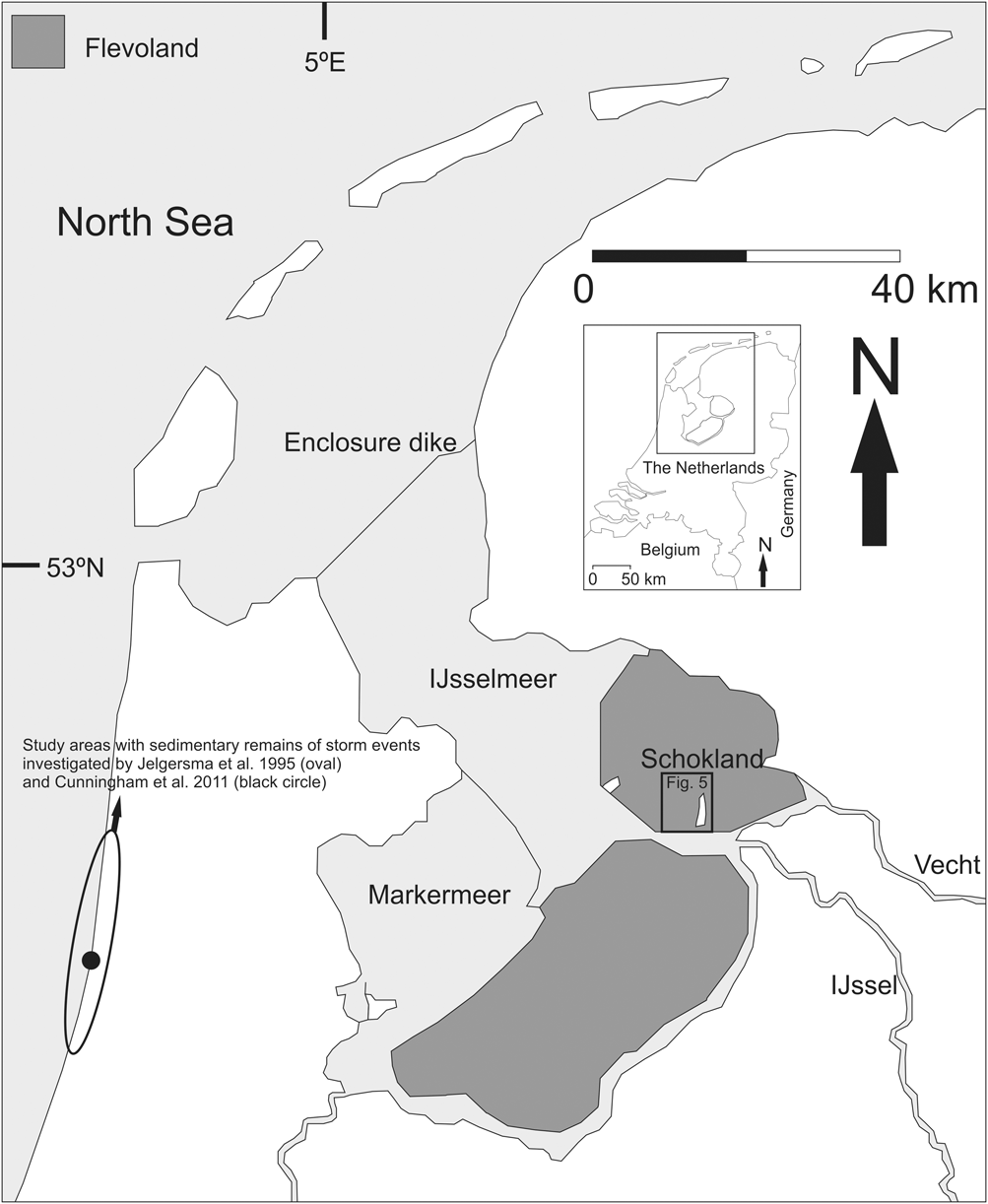
Location of study area (grey area) and Fig. 5 within the Netherlands. Location of study areas with sedimentary remains of storm events investigated by Jelgersma et al. (Reference Jelgersma, Stive and Van der Valk1995) and Cunningham et al. (Reference Cunningham, Bakker, Van Heteren, Van der Valk, Van der Spek, Schaart and Wallinga2011) are also shown.

Since the reclamation of the Noordoostpolder from the Zuiderzee, the Holocene subsurface of Schokland has been the topic of a number of studies that deal with sand, clay and peat deposits (Van der Heide & Wiggers, Reference Van der Heide and Wiggers1954; Wiggers, Reference Wiggers1955; Gotjé, Reference Gotjé1993; Van Balen, Reference Van Balen2008). However, detailed studies dealing with the uppermost ∼2-m thick clay cover on the former island do not yet exist. The clay unit represents a transition from a peatland to a marine environment. As it was deposited on the island during human occupation, a detailed study of the recent clay layer provides a unique opportunity to combine geological and historical archives to reconstruct the island’s flooding history during the last 1200 years. In general, the combined use of such archives is rare due to the lack of long-term historical paleostorm records. Studies on storm chronologies of the late Holocene from around the world therefore depend mainly on geological archives (e.g. Eden & Page, Reference Eden and Page1998; Lamoureux, Reference Lamoureux2000; Ambers, Reference Ambers2001; Cunningham et al., Reference Cunningham, Bakker, Van Heteren, Van der Valk, Van der Spek, Schaart and Wallinga2011; Dezileau et al., Reference Dezileau, Sabatier, Blanchemanche, Joly, Swingedouw, Cassou, Castaings, Martinez and Von Grafenstein2011). However, few studies exist where historical sources are integrated into coastal reconstructions (e.g. Vos & Van Heeringen, Reference Vos, Van Heeringen and Fischer1997; Beekman, Reference Beekman2006; Termote, Reference Termote, Coosen, Mees, Seys and Fockedey2006). Although such a study exists for Schokland, the reconstruction was limited to the 18th and 19th centuries (Moerman & Reijers, Reference Moerman and Reijers1925). The major objective of this research is to reconstruct the depositional history of Schokland over the past 1200 years by analysis of the uppermost clay deposit. More specifically we want to (1) determine the depositional mechanisms and the spatial distribution of the thickness of the youngest clay layer, (2) assess the role of storm events and (3) evaluate the role of anthropogenic factors (i.e. embankments, dwelling mounds) in the sedimentary record of Schokland during the past 1200 years. To this end we used a literature study, analyses of a digital elevation model and laboratory analyses on new corings. The laboratory analyses included grain-size distribution (GSD; N = 356), end-member modelling (unmixing GSDs), carbonate and organic matter content (N = 398) and palaeo-ecological indicators (foraminifera, bivalves and ostracods, N = 73). To improve the chronological framework of the island’s depositional history, we present three new 14C AMS datings.
Geological and cultural setting
Palaeogeographical context
The oldest part of the landscape of the study area was formed during the Saalian glaciation of the Netherlands, corresponding to Marine Isotope Stage MIS 6 (cf. Bassinot et al., Reference Bassinot, Labeyrie, Vincent, Quidelleur, Shackleton and Lancelot1994). Glacial till and glaciofluvial sand were deposited on the central north part of Schokland (De Waard, Reference De Waard1949; Brouwer, Reference Brouwer1950; Wiggers et al., Reference Wiggers, De Jong and Spanjer1962) as a result of the southward expansion of the Fennoscandian ice sheet (cf. Van den Berg & Beets, Reference Van den Berg, Beets and Van der Meer1987). The ridge formed by these glacial deposits is still visible in the topography of Schokland (Figs 2 and 3).
Digital elevation models (DEMs) of Schokland. The maps have a Rijksdriehoekstelsel coordinate system and the elevation is indicated in centimetres relative to Dutch O.D. A. Elevation top Pleistocene. In the northern part the ridge of glacial till is visible and in the south the ridge of aeolian sands (compiled from Seidel, Reference Seidel1804; Gotjé, Reference Gotjé1993; Schiltmans, Reference Schiltmans2005; RIJP corings (www.dinoloket.nl); TNO corings and cone penetrations tests (www.dinoloket.nl)). B. Elevation of current surface (Actueel Hoogtebestand Nederland) and location of cores, depressions documented by Eilander & Heijink (Reference Eilander and Heijink1990), 14C AMS dates (blue circles, this study) and 14C radiocarbon date (blue square, Ente et al., Reference Ente, Koning and Koopstra1986).
Cross-section of Schokland and surrounding area with lithologic data. Glacial till (Saalian) and coversand/dune/fluvial deposits (Late Pleniglacial and Late Glacial) are presented together with a Holocene depositional sequence. The Medieval and Modern Period clay sequence is divided into two parts: clay with low CaCO3 content and plant remains at the base (brackish) and clay containing marine shells at the top (marine). Each of these two parts can be differentiated into a terrestrial facies (Schokland) and a subaquatic facies (surrounding area) (after Van der Heide & Wiggers, Reference Van der Heide and Wiggers1954, appendix).
During the Late Pleniglacial (∼ 29–14.7. ka), fluvial deposits were formed in a braided river system representing the precursors of the Holocene Vecht and IJssel river systems (Wiggers, Reference Wiggers1955). The incisions of the river branches created local, elongated depressions in the Pleistocene surface, where younger deposits thus attain larger thicknesses (Figs 2 and 3). Along the banks of these river branches aeolian deposits were laid down. The aeolian deposits are known as coversand deposits.
During the Younger Dryas, between ∼10950 and 10150 radiocarbon years BP, parallel ridges of aeolian sands formed along the banks of the rivers. These ridges probably formed due to increased aridity of the environment as well as the braided style of the fluvial system. Granulometric research indicated grain sizes coarser than the texture of coversand deposits, thus confirming that these ridges are river dunes (Wiggers, Reference Wiggers1955). Examples of such ridges are located on the northern flank of the Saalian glacial deposits (Van de Plassche et al., Reference Van de Plassche, Bohncke, Makaske and Van der Plicht2005) and on the southern tip of Schokland (Figs 2A and 3).
The glacial, aeolian and fluvial activity has created an undulating topography of the top Pleistocene deposits at Schokland, varying from –9 m to –3 m relative to Dutch Ordnance Datum (O.D.) (Fig. 2A). For a detailed description of the Pleistocene deposits see De Waard (Reference De Waard1949), Wiggers (Reference Wiggers1955), Ter Wee (Reference Ter Wee1966), Doppert et al. (Reference Doppert, Ruegg, Van Staalduinen, Zagwijn, Zandstra, Zagwijn and Van Staalduinen1975), Van den Berg & Beets (Reference Van den Berg, Beets and Van der Meer1987) and Busschers et al. (Reference Busschers, Kasse, Van Balen, Vandenberghe, Cohen, Weerts, Wallinga, Johns, Cleveringa and Bunnik2007).
The Pleistocene deposits on Schokland are overlain by a sequence of Holocene peat and clay deposits up to 7 m thick (Van der Heide & Wiggers, Reference Van der Heide and Wiggers1954) (Fig. 3). The basal part of the peat was 14C-dated at 5820 ± 60 BP (Gotjé, Reference Gotjé1993). Its formation is related to the relative sea level rise during the Holocene, resulting in a general transgression and flooding of the Zuiderzee area. The combination of warmer and wetter conditions led to the formation of a tidal lagoon fringed by swamps. The most important connection to the North Sea was via the Bergen tidal inlet (Fig. 4). Around 3450 BP, after closure of the inlet, an extensive poorly drained swamp area developed in the Schokland region. The peat formed in this swamp is characterised by a vegetation succession showing an upward transition towards oligotrophic conditions (De Mulder & Bosch, Reference De Mulder and Bosch1982; Gotjé, Reference Gotjé1993).
Palaeogeographical maps of the Zuiderzee area, showing the Bergen tidal inlet (2750 BC map), the opening of the tidal inlet east of Texel (AD 100 map) and the expansion of the Zuiderzee between AD 800 and 1500. The development shown here illustrates the isolation of the peat island of Schokland through time (modified after Vos et al., Reference Vos, Bazelmans, Weerts and Van der Meulen2011).
Around 2000 BP a tidal inlet formed east of the present-day island of Texel in the northwestern part of the Netherlands (Fig. 4, Beets & Van der Spek, Reference Beets and Van der Spek2000). This tidal inlet connected the North Sea with the poorly drained swamp area in the Schokland region. The top of the peat at Schokland was 14C-dated at ∼1200 ± 50 BP (Ente et al., Reference Ente, Koning and Koopstra1986), providing a maximum age for the overlying clay deposits. Van der Heide & Wiggers (Reference Van der Heide and Wiggers1954) and Wiggers (Reference Wiggers1955) divided the clay cover at Schokland into two parts: clay with low CaCO3 content at the base (brackish) and clay containing marine shells at the top (marine) (Fig. 3). Because of the enlargement of the tidal inlet east of Texel from around 1200 BP (Wiggers, Reference Wiggers1955), Schokland became increasingly vulnerable to storms. Continuing expansion of this tidal inlet resulted in the formation and rapid enlargement of the Zuiderzee in the next few centuries (Fig. 4).
From around AD 800 a series of major storm events eroded parts of Schokland, thereby decreasing the extent of the peat area in marked stages (Fig. 5). The difference in peat coverage around Schokland at AD 800 in Figs 4 and 5 is due to the higher resolution of Fig. 5. The beginning of marine influence on Schokland is possibly related to the storm of AD 838. While, the storm of AD 1170 is regarded as the start of the formation of the Zuiderzee (Gottschalk, Reference Gottschalk1971; Buisman, Reference Buisman1995), the storm of AD 1248 is assumed to be the last event in the formation of the Zuiderzee (Buisman, Reference Buisman1995). The peat area which connected Schokland to the mainland was most likely eroded due to the storm event of AD 1446 (Gottschalk, Reference Gottschalk1975; Hogestijn, Reference Hogestijn and Huizinga1992). Since the end of the 19th century no further erosion of the island has taken place, as shown by the palaeo-coastlines, which are similar to those of present-day Schokland (Moerman & Reijers, Reference Moerman and Reijers1925; Van der Heide & Wiggers, Reference Van der Heide and Wiggers1954). With the reclamation of the Noordoostpolder around AD 1939, Schokland became a land-locked island and no further flooding and sedimentation took place. However, since that time the surface of Schokland has subsided due to peat compaction (Van den Biggelaar & Pieters, Reference Van den Biggelaar, Pieters, Van Diepen, Van der Most and Pruntel2012).
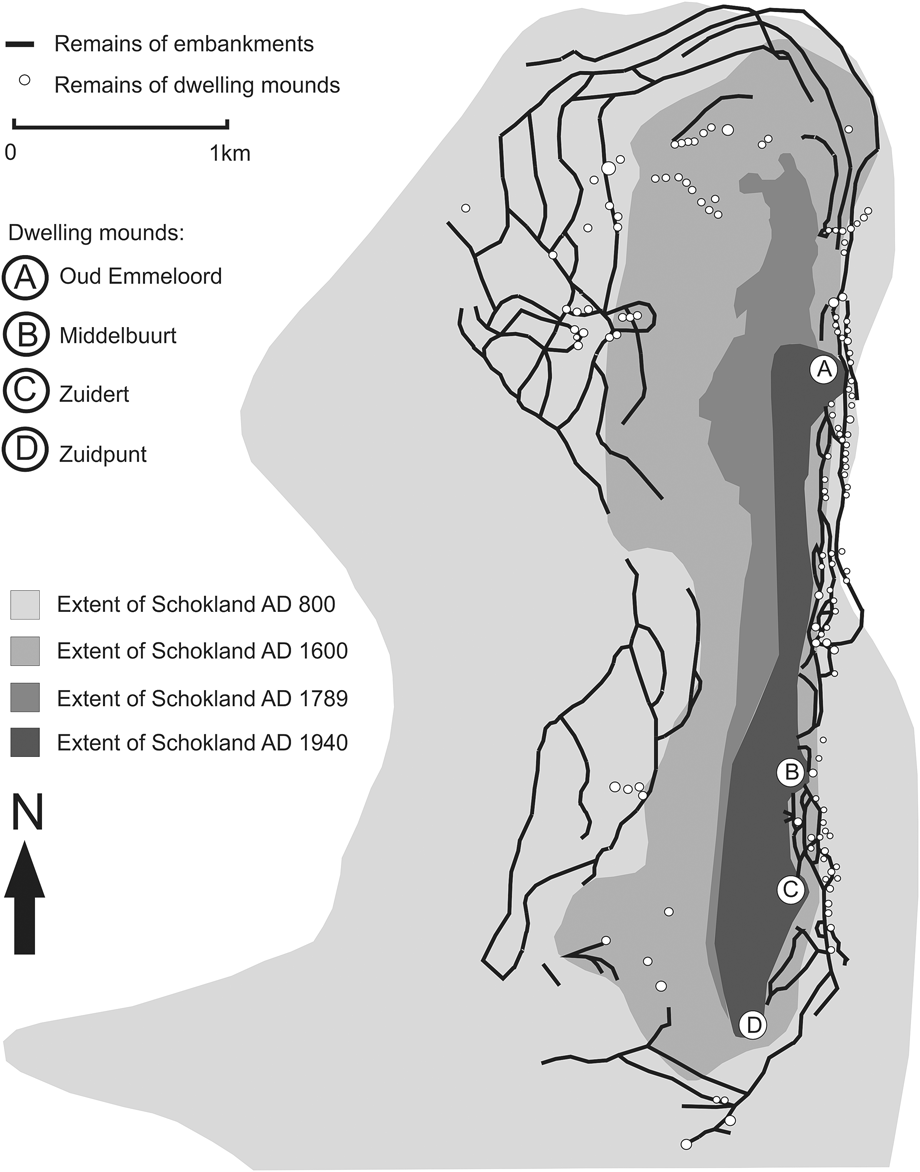
The reduction of Schokland since AD 800. The locations of embankments and dwelling mounds around Schokland are shown (after Van der Heide & Wiggers, Reference Van der Heide and Wiggers1954, Fig. 7, with modifications from Van Doesburg & Mauro, Reference Van Doesburg and Mauro2007; http://historische-luchtfoto.flevoland.nl/).
The surface of the former island has an undulating character, varying from –3.2 to 2.4 m relative to Dutch O.D. (Fig. 2B), that is either anthropogenic (dwelling mounds) or natural (depressions) in origin. According to Eilander & Heijink (Reference Eilander and Heijink1990), depressions were formed by embankment breaches during storm events (Fig. 2B). In response to the storm events, four artificial hills were created, which are still visible on Schokland ( i.e. Zuidpunt, Zuidert, Middelbuurt and Emmeloord, Fig. 5) (Van der Heide & Wiggers, Reference Van der Heide and Wiggers1954). They are the most tangible evidence of people’s struggle against the sea on the former island.
Habitation history
Evidence of human presence on aeolian river dunes and a coversand ridge in the direct vicinity of Schokland dates from the Late Palaeolithic to the Early Iron Age, between ∼10000 and 2500 BP (Hogestijn, Reference Hogestijn1991; Ten Anscher & Gehasse, Reference Ten Anscher, Gehasse, Bloemers, Groenman-van Waateringe and Heidinga1993; Gehasse, Reference Gehasse1995; Ten Anscher, Reference Ten Anscher2012). The poorly drained peat area prohibited human occupation in the area from the Middle Iron Age to the Late Medieval period. The formation of the Almere Lagoon around 1200 BP resulted in improved drainage of the area (Wiggers, Reference Wiggers1955; Ente et al., Reference Ente, Koning and Koopstra1986) (Fig. 4), making it possible for people to settle again. Archaeological remains indicate renewed human occupation between AD 1050 and 1100 (Hogestijn et al., Reference Hogestijn, Bartels, Laarman and Tiesinga1994), signifying a minimum age for the start of the reclamation of the peatlands. The reclamation caused compaction and oxidation of the peat, which in turn resulted in a relative rise in sea level. Consequently, around AD 1200, embankments were constructed to protect the inhabitants against the increasing marine influence (Van der Heide & Wiggers, Reference Van der Heide and Wiggers1954; Hogestijn et al., Reference Hogestijn, Bartels, Laarman and Tiesinga1994). During the AD 1375 storm surge the village of Ens, located southwest of modern-day Schokland, was flooded (Hogestijn, Reference Hogestijn and Huizinga1992). Schokland’s separation from the mainland around AD 1446 (Gottschalk, Reference Gottschalk1975; Hogestijn, Reference Hogestijn and Huizinga1992) led to the migration of its inhabitants to the artificially raised areas on Schokland (Zuidpunt, Zuidert, Middelbuurt and Emmeloord, Fig. 5) (Van der Heide & Wiggers, Reference Van der Heide and Wiggers1954). Unglazed Siegburg stoneware (15th century), present in the lowest raised anthropogenic layer of Zuidert, confirms this date (Van der Heide, Reference Van der Heide1950). At the beginning of the 17th century a wooden sea defence existed. It was most probably built in response to the storm event of AD 1570 to protect the inhabitants against flooding. The damage inflicted on this sea defence by storm surges (e.g. the storm event of AD 1625) (Buisman, Reference Buisman2000) resulted in the introduction of a new tax for ships visiting Schokland to finance the repairs. This tax was collected for the maintenance of the wooden sea defence until AD 1763 (Resolutie Ridderschap en Steden van Overijssel 1629 and 1763 in Geurts, Reference Geurts1991). Because of the increasing impact of the Zuiderzee on the inhabited part of Schokland (Fig. 5) and the effect of the storm event of AD 1775 on the former island (Hering, 1776), the sea defence on the western part of Schokland was replaced by a stone embankment at the beginning of the 19th century (Moerman & Reijers, Reference Moerman and Reijers1925). The stone embankment and the former island were heavily damaged by the storm surges of AD 1824 and 1825 (Moerman & Reijers, Reference Moerman and Reijers1925), which led to discussions on the evacuation of the former island. In 1859 the Schokland population was evacuated because of the increasing maintenance costs of the sea defence and the growing poverty of the population (Handelingen Staten-Generaal, 1857–1858, 1858–1859 in Geurts, Reference Geurts1991). After the evacuation, the former island was hit by the storm surges of AD 1877 and 1916. Although after the AD 1877 storm surge new plans were proposed to reclaim the Zuiderzee area, the plan concerning the construction of the Zuiderzee reclamation works was not accepted until after the AD 1916 storm event (Geurts, Reference Geurts1991). As the lighthouse on the Zuidpunt and the harbour at Emmeloord were of great importance to sailors and fishermen, a harbour master, a lighthouse watchman and maintenance workers continued to live on the island until AD 1942, the year the Noordoostpolder was completed (Van der Heide & Wiggers, Reference Van der Heide and Wiggers1954; Van der Heide, Reference Van der Heide1959).
Material and methods
Lithostratigraphic mapping was carried out with the help of six evenly distributed coring-based cross-sections orientated east–west across Schokland and comprising a total of 35 cores (Fig. 2).
The cores were taken with 3- and 6-cm diameter gouges and an Edelman auger of 7 cm in diameter. The length of the cores varied from 1.20 to 6.75 m. The auger was used for the dry top 1 m of clay, while the gouges were used from 1 m below the surface, where moist conditions prevail. In the field the cored sediments were described lithologically. The descriptive parameters include grain size, colour, oxidation/reduction, CaCO3 content, content of organic (shells, shell fragments, humus, plants and roots) and non-organic (Fe, Mn) components, sedimentary structures and archaeological remains. The Munsell Soil Color Chart (2000 edition) was used for the description of the colour, while the remaining parameters were described with the use of standard guidelines (Bosch, Reference Bosch2000). Changes in one of the descriptive parameters determined the sample interval in 32 (out of 35) cores, yielding an average of five samples per core. On each sample one grain size (GSA) and one thermogravimetric analysis (TGA) were performed. To determine the GSD of the samples a Helos Laser Particle Sizer was used. Prior to the grain-size measurements, samples were treated with H2O2 (30%) and HCl (10%) to remove organic matter and carbonate. TGA was used to determine the carbonate and organic matter content of the sample, both expressed in weight percentage (wt%) of dry mass. This weight loss was measured by stepwise heating of the sample from 25 to 1000°C.
Three complete cores (cores 36, 37 and 39) were analysed in the Sediment Laboratory of VU University Amsterdam. They were sampled at 10-cm intervals for TGA, GSA and palaeo-ecological indicators (foraminifera, bivalves and ostracods). In addition, one of the cores (core 36) was sampled at 1-cm intervals for TGA and GSA (155 samples). Furthermore, from each of the three complete cores a sample was taken from organic material for AMS radiocarbon dating to improve the chronological framework. Terrestrial plant, seed and wood material was manually selected from the 2-cm thick samples to avoid contamination with older or younger carbon. Whenever sufficient material was available, samples were pre-treated with the acidic-alkali-acid (AAA) method of Mook & Streurman (Reference Mook, Streurman, Mook and Waterbolk1983). Radiocarbon dates are given with a 2-sigma error range (95% probability) in calibrated years BP, unless stated otherwise. Calibration was conducted with the software developed by Talma & Vogel (Reference Talma and Vogel1993) using the IntCal09 calibration curve (Reimer et al., Reference Reimer, Baillie, Bard, Bayliss, Beck, Blackwell, Bronk Ramsey, Buck, Burr, Edwards, Friedrich, Grootes, Guilderson, Hajdas, Heaton, Hogg, Hughen, Kaiser, Kromer, McCormac, Manning, Reimer, Richards, Southon, Talamo, Turney, Van der Plicht and Weyhenmeyer2009). The combined field and laboratory sampling strategy yielded 398 TGA, 356 GSA, 73 palaeo-ecological and 3 AMS radiocarbon samples.
End-member modelling was applied to the complete GSD dataset to infer depositional mechanisms (Weltje, Reference Weltje1997; Prins & Weltje, Reference Prins, Weltje, Harbaugh, Watney, Rankey, Slingerland, Goldstein and Franseen1999; Prins et al., Reference Prins, Postma and Weltje2000; Reference Prins, Bouwer, Beets, Troelstra, Weltje, Kruk, Kuijpers and Vroon2002; Weltje & Prins, Reference Weltje and Prins2003; Parris et al., Reference Parris, Bierman, Noren, Prins and Lini2009). The end-member modelling algorithm (EMMA) unmixes the sediment into several grain-size populations, or end members (EMs) (Weltje, Reference Weltje1997). As each EM may correspond to a specific depositional mechanism or provenance area (Weltje & Prins, Reference Weltje and Prins2003), the best approximation for the number of EMs, including their ratio and vertical and lateral dispersal pattern, provides a tool to infer genetic interpretations of the grain-size dataset. The added value of this data-analysis technique relative to other methods is explained in detail by Weltje & Prins (Reference Weltje and Prins2003, Reference Weltje and Prins2007).
Results and interpretation
Cross-sections with the lithostratigraphic data from the corings of profiles A, B and F from Schokland and corresponding TGA and GSA results are shown in Fig. 6. Palaeo-ecological data derived from the cores are shown in Table 1. A detailed view of core 36 (profile B) with corresponding grain size, TGA, palaeo-ecological indicators and EM modelling results is shown in Fig. 7.
Profiles A, B and F with lithologic data. Based on the calibration experiment by Vriend & Prins (Reference Vriend and Prins2005) it is assumed that the end-member (EM) proportions (within the siliclastic sediment fraction) expressed by volume are similar to the EM proportions expressed by weight. The proportional contribution of the EMs to the bulk sediment samples was re-scaled in proportion to the organic matter and carbonate contents (wt%). In effect, organic matter (OM) and carbonate are considered as two additional EMs (next to the grain-size based EMs), therefore OM + carbonate + EMs = 100%.
Palaeo-ecological data from the clay deposit (unit 3) from all profiles across Schokland1
1 Cores that were examined for forams and ostracods are located at profiles A, B and F; at other profiles only plant remains and shell (fragments) were documented.
Coring 36 with grain size, palaeo-ecological and end-member modelling data showing (a) the limited availability of foraminifera, (b) the lack of ostracods and (c) a general coarsening upward trend related to the gradual increase of marine inundation of the island. Black arrows indicate coarse grain-size peaks that are possibly related to storm events that eroded parts of Schokland. Dates in black indicate the age of the upper and lower boundaries of each subunit: 1, AD 1939, construction Noordoostpolder; 2, AD 1600, historical sources mentioning the increasing influence of the Zuiderzee on Schokland; 3, AD 1050–1200, initial reclamation of the peatlands in conjunction with the start of construction of the oldest embankments; 4, cal AD 770–900 and cal AD 920–940 AMS date (this study) of the top of unit 2. Meaning of the scale for palaeo-ecological indicators: 1, few (0–1%); 2, moderate (1–10%); 3, abundant (>10%). For legend and location of coring 36 on profile B, see Fig. 6.
The shallow subsurface of Schokland can be subdivided into three main depositional units. Unit 1 consists of Pleistocene sands. The sands are slightly silty, light to dark brownish grey or greyish brown, and poor in CaCO3 (max. ∼0.5 wt%) and organic material (1.4–5.2 wt%). Unit 2 consists predominantly of reddish brown mineral-poor reed peat and/or sedge peat. The peat has a variable thickness across the former island. In the northernmost part, where the top of the Pleistocene sand has the lowest elevation, the thickness of the peat measures 4–5 m. In areas where the top of the Pleistocene sand has a high elevation the peat thickness is around ∼0.5–1.5 m or ∼1.5–2.5 m (Fig. 8), levelling the palaeo-relief. The top of the peat has been dated in cores 36 and 37 (Fig. 2B; Table 2). The third unit contains brown to brownish-grey medium to very silty clay and has a variable thickness. This unit is the subject of this study.
Thickness of peat deposits in centimetres and locations of cores taken for this study. The map has a Rijksdriehoekstelsel coordinate system (compiled from Seidel, Reference Seidel1804; Gotjé, Reference Gotjé1993; Schiltmans, Reference Schiltmans2005; RIJP-corings (www.dinoloket.nl); TNO corings and cone penetrations tests (www.dinoloket.nl)).
14C dates of top peat samples in Schokland. One 14C radiocarbon bulk sample (Ente et al., Reference Ente, Koning and Koopstra1986) and two 14C AMS dates (cores 36 and 37). Sample core 39 contained insufficient above-ground organic material for AMS date. No AAA pre-treatment was possible on core 37 sample due to small sample size (0.8 mg). 14C radiocarbon age of Ente et al. (Reference Ente, Koning and Koopstra1986) was calibrated with the software developed by Talma & Vogel (Reference Talma and Vogel1993) using the IntCal09 calibration curve (Reimer et al., Reference Reimer, Baillie, Bard, Bayliss, Beck, Blackwell, Bronk Ramsey, Buck, Burr, Edwards, Friedrich, Grootes, Guilderson, Hajdas, Heaton, Hogg, Hughen, Kaiser, Kromer, McCormac, Manning, Reimer, Richards, Southon, Talamo, Turney, Van der Plicht and Weyhenmeyer2009). For location of samples see Fig. 2B.
Subdivision of the clay unit
Based on lithological trends the clay deposit (unit 3) can be subdivided into three subunits. The boundary between the peat layer (unit 2) and the basal clay deposit (subunit 3.1) is based on a sharp decrease in organic matter content (Fig. 7). Subunit 3.1 consists of clayey peat with a gradual transition to very humic silty clay (Fig. 9A). It contains in situ plant remains and is poor in CaCO3. In the northern part of Schokland the arenaceous foraminifer Trochammina sp. dominates in this subunit, while in the southernmost part these foraminifers are absent from this subunit (Fig. 7; Table 1). Trochammina sp., in the absence of calcareous foraminifera, is indicative of a weakly brackish environment. An increase in sand and CaCO3 content, and a sharp decrease in plant material defines the transition from underlying subunit 3.1 to subunit 3.2 (Fig. 7).
Detailed view of parts of each of the subunits 3.1 (core 36), 3.2 (core 36) and 3.3 (core 37). Blue arrows in B highlight some 0.1- to 2-cm thick layers.
Subunit 3.2 consists of brownish-grey very silty clay (Fig. 9B) and contains more sand and CaCO3 than the underlying subunit 3.1. Thin layers of reworked plant material are also present. Subunit 3.2 is dominated by calcareous foraminifera (Ammonia beccarii, Haynesina sp. and Elphidium sp.). However, in the southernmost part of Schokland subunit 3.2 also contains some Trochammina sp. (Table 1). In addition, the southern part of Schokland contains (fragments of) bivalve shells and ostracods in subunit 3.2, while in the northern area shell material and ostracods are almost absent (Figs 7 and 10; Table 1).
Number of 0.1- to 2-cm thick layers of coarser material embedded in the clayey matrix and distribution of shells and/or shell fragments per coring in subunits 3.2 and 3.3. These layers and shell material are absent in subunit 3.1.
The transition to subunit 3.3 is marked by an increase in sand and CaCO3 content (Figs 6 and 7). Subunit 3.3 forms the top of the clay deposit and consists of shell-rich greyish-brown medium silty clay with low organic matter content (Fig. 9C). This subunit contains a higher sand and CaCO3 content compared to underlying subunits. While within this subunit bivalve shell material is present across the former island, ostracods and Ammonia beccarii are primarily present in the southern part (Figs 7 and 10; Table 1).
The thickness of the three lithological subunits varies across Schokland (Fig. 11A–C). Subunit 3.1 (0–1 m thick) contributes very little to the overall thickness of the clay cover and is predominantly found at the western edge (0–0.5 m) and the north–south central axis (0–1 m) of Schokland. Subunit 3.2 forms the main body of clay deposit (0–2.5 m thick). The thickest clay deposits of subunit 3.2 have been found on the western (1–2 m) and eastern (0.5–2 m) edge and the southernmost part (1–2.5 m) of the former island. The clay thickness of subunit 3.3 is intermediate between that of subunits 3.1 and 3.2, with the majority of the clay being deposited in the north–south central axis (0.5–1.5 m) and the southernmost part of Schokland (1–2 m). For both subunits 3.2 and 3.3 the thickest clay cover was found on the southernmost part of the former island and the thinnest on the northernmost area.
Thickness (in centimetres) of clay subunits 3.1, 3.2 and 3.3.
Within subunits 3.2 and 3.3 several 0.1- to 2-cm thick layers of coarser sediment occur (Fig. 9B), sometimes in combination with shell and/or reworked plant material. The number of these layers varies across the former island. Overall, the majority of these layers were found in the central to north area of Schokland and in its southernmost area. However, within subunit 3.2 these layers are primarily located along the western and eastern edges, while within subunit 3.3 the layers are present in the north–south central axis (Fig. 10).
Overall, the results of the analyses show that clay unit 3 predominantly has an upward increasing sand content. Laterally, the sand content decreases from west to east across the entire island. While organic matter content decreases towards the top of the clay deposit, the CaCO3 content increases (Figs 6 and 7; Table 1).
Grain-size analysis
The grain-size dataset of all cores at Schokland has been unmixed using EMMA. Goodness-of-fit statistics indicate that five EMs are needed to satisfactorily describe the grain-size dataset (r2 mean = 0.98). The five EMs of the top of the Pleistocene sand (unit 1) and the uppermost clay deposits (unit 3) each have clearly defined modes at 420 µm (EM 1; range ∼180–1000 µm), 210 µm (EM 2; range ∼45–500 µm), 44 µm (EM 3; range ∼11–125 µm), 19 µm (EM 4; range ∼2–63 µm) and 7 µm (EM 5; range ∼0–32 µm) (Fig. 12). The sand of unit 1 consists primarily of EM 2 (210 µm), but in the central to northern part of the subsurface of Schokland a large contribution of EM 1 (420 µm) was found at the western edge (Fig. 13). Grain-size analyses on Middle and Late Pleistocene and Holocene sediments of the Noordoostpolder indicate that the coarsest EM (EM 1) may correspond to the grain size of Late Glacial river dunes (range ∼125–600 µm; Wiggers, Reference Wiggers1955; Van Loon & Wiggers, Reference Van Loon and Wiggers1976). EM 2 closely resembles the grain size of glaciofluvial sand (range ∼50–420 µm; Wiggers et al., Reference Wiggers, De Jong and Spanjer1962) or Late Glacial coversand (range ∼50-300 µm; Wiggers et al., Reference Wiggers, De Jong and Spanjer1962) and the three fine-grained EMs may be indicative of marine silty clay and fine sandy deposits (range ∼0–105 µm; Wiggers, Reference Wiggers1955; Wiggers et al., Reference Wiggers, De Jong and Spanjer1962; Van Loon & Wiggers, Reference Van Loon and Wiggers1975a,Reference Van Loon and Wiggersb). Further research is needed to determine the influence of the IJssel fluvial sediments as well as the glacial till as a sediment source for the three fine-grained EMs.
Grain-size distribution of the five EMs based on 356 samples. A comparison to grain-size analyses on Middle and Late Pleistocene and Holocene sediments of the Noordoostpolder may indicate the following sediment sources for the EMs: EM 1: (eroded) Late Glacial river dune deposits; EM 2: (abraded) Late Glacial cover sand deposits; EMs 3–5: Late Holocene marine silty clay and fine sandy deposits (Wiggers, Reference Wiggers1955; Wiggers et al., Reference Wiggers, De Jong and Spanjer1962; Van Loon & Wiggers, Reference Van Loon and Wiggers1975a,Reference Van Loon and Wiggersb; Van Loon & Wiggers, Reference Van Loon and Wiggers1976).
Results of end-member modelling (EMM) data for unit 1 and subunits 3.1, 3.2 and 3.3.
Within the clay deposit (unit 3) the proportion of EMs 2 and 3 gradually increases from bottom to top (Fig. 13). Apart from a vertical trend in the EM proportions in unit 3 there is also a lateral trend. In subunit 3.2 the north–south central axis of the former island consists of higher proportions of fine silty and clayey material (EMs 4 and 5) than the western and eastern edges. Within subunit 3.3 the northern part of Schokland contains coarser material than the southern part. While in the northern part of the former island a high proportion of medium fine sand and very coarse silt (EMs 2 and 3) is present, the southern part is dominated by silty and clayey material (EMs 3, 4 and 5; Fig. 13).
Subunits 3.2 and 3.3 contain 0.1- to 2-cm thick layers of coarser material intercalated in the clayey matrix. The grain size of these layers varies vertically and laterally across the former island (Fig. 14). Within subunit 3.2 these layers are dominated by very coarse and fine silt (EMs 3 and 4). In the southernmost area, subunit 3.2 also has two layers with a high proportion of coarse sand (EM 1).
Results of end-member modelling (EMM) data for 0.1- to 2-cm thick silty and sandy layers per coring within subunits 3.2 and 3.3.
Within subunit 3.3 the coarsest of the 0.1- to 2-cm thick layers are found in the northern part. The layers in the northern half of Schokland are dominated by medium fine sand (EM 2) and very coarse silt (EM 3), while those in the southern half consist of very coarse silt (EM 3; Fig. 14).
Apart from lateral trends in grain size of the 0.1- to 2-cm thick layers there is also a vertical trend. A detailed view of this vertical trend is provided by the 1-cm resolution grain-size analyses and EMMA results of core 36 from the central north of Schokland. The EMMA results indicate that both the 0.1- to 2-cm thick layers and the clayey matrix have a gradual upward increase in the proportion of coarser EMs (Fig. 7).
There is a positive correlation between the number of the 0.1- to 2-cm thick silty and sandy layers and the availability of Pleistocene sand in the direct vicinity of Schokland. Areas where the top Pleistocene sand is relatively close to the surface (central to north and southernmost areas) contain most of these layers in the clay (compare Figs 2 and 10). In the northern part of Schokland these layers consist primarily of medium fine sand (EM 2). The medium fine sand deposits (EM 2) within the clay are interpreted as reworked coversand deposits. In the southwest of the former island several layers contain a high proportion of coarse sand (EM 1), which are interpreted as eroded river dune deposits based on their grain-size mode and their close proximity to a river dune in the southeastern part (Wiggers, Reference Wiggers1955). The results from the EMMA and the positive correlation indicate that the sandy material in the surficial clay deposit originates from erosion of the Pleistocene subsoil in close proximity to Schokland, and that only a little lateral sediment transport has occurred.
Paleogeographical development
The presence of in situ plant material, the gradual transition from peat to clay, the presence of agglutinated foraminifera (Trochammina sp.) and the low CaCO3 content all point to low energetic conditions during the time of deposition of subunit 3.1. These findings lead to the conclusion that this area was distant from tidal influence during this period. This is consistent with the results of previous research which also indicate the presence of clay with low CaCO3 content at Schokland (Van der Heide & Wiggers, Reference Van der Heide and Wiggers1954; Wiggers, Reference Wiggers1955). The results from previous and current research point to weakly brackish conditions during the deposition of subunit 3.1. The lowest subunit (3.1) of the surficial clay is therefore interpreted to have been formed in a peatland that was gradually inundated.
The top of the peat underlying subunit 3.1 was 14C-dated by Ente et al. (Reference Ente, Koning and Koopstra1986) at 1200 ± 50 BP (cal AD 680–900 and cal AD 920–970; Fig. 2B; Table 2). This 14C date was obtained from a conventional radiocarbon analysis on a bulk sample (Carex peat) and may therefore be subject to significant errors (Kilian et al., Reference Kilian, Van der Plicht and Van Geel1995; Shore et al., Reference Shore, Bartley and Harkness1995; Nilsson et al., Reference Nilsson, Klarqvist, Bohlin and Possnert2001). However, in the Schokland area, errors in bulk-dated peat samples due to root rejuvenation were most likely balanced out by ageing effects (Van de Plassche et al., Reference Van de Plassche, Bohncke, Makaske and Van der Plicht2005). The 14C AMS dates obtained in this study (Fig. 2B; Table 2), have one older age (cal AD 410–550, core 36) and one similar age (cal AD 770–900 and cal AD 920–940, core 37) compared to the peat bulk 14C date of Ente et al. (Reference Ente, Koning and Koopstra1986) (cal AD 680–900 and cal AD 920–940). The 14C AMS date of core 36 is probably too old because of considerable erosion of the top of the peat at Schokland (Gotjé, Reference Gotjé1993). In this study the 14C AMS date of cal AD 770–900 and cal AD 920–940 for the top of the peat is therefore used to indicate a maximum age of subunit 3.1.
In the overlying subunit 3.2 the presence of calcareous foraminifera (Ammonia beccarii, Haynesina sp. and Elphidium sp.), ostracods and bivalve shells points to a brackish environment. This is a new subunit which in previous results was interpreted as being part of the marine clay deposited since the start of the 17th century (Van der Heide & Wiggers, Reference Van der Heide and Wiggers1954; Wiggers, Reference Wiggers1955). The transition from a weakly brackish to a brackish environment occurred gradually because there are no sharp boundaries within this subunit other than those related to the 0.1- to 2-cm thick silty and sandy layers, and the layers of reworked plant material. The start of the increasing marine influence at Schokland (base subunit 3.2) possibly occurred between AD 1050 and 1200. AD 1050 (Hogestijn et al., Reference Hogestijn, Bartels, Laarman and Tiesinga1994) is the minimum age of initial reclamation of the peatlands that resulted in oxidation and subsidence of the peat, which led to a rise in relative sea level. AD 1200 marks the beginning of the construction of the embankments at Schokland (Van der Heide & Wiggers, Reference Van der Heide and Wiggers1954; Hogestijn et al., Reference Hogestijn, Bartels, Laarman and Tiesinga1994).
The top subunit (3.3) was dominated by marine influence, as indicated by low organic matter content, high CaCO3 content, the presence of ostracods and calcareous foraminifera as well as the large amount of bivalve shell material. This is also in agreement with visitor accounts describing the marine influence on the former island (e.g. Mees, Reference Mees1847; Meijlink, Reference Meijlink1858) and the results from previous research which confirm the presence of clay with marine shells at Schokland (Van der Heide & Wiggers, Reference Van der Heide and Wiggers1954). The transition from a brackish (subunit 3.2) to a marine environment (subunit 3.3) is inferred from the gradual increase in CaCO3 content and the gradual decrease in organic matter content within unit 3. This transition was previously dated at approximately AD 1600, based on historical data (Van der Heide, Reference Van der Heide and Wessels1951; Van der Heide & Wiggers, Reference Van der Heide and Wiggers1954; Wiggers, Reference Wiggers1955).
Overall, on Schokland the number of the 0.1- to 2-cm thick silty and sandy layers in unit 3 decreases towards the east, indicating that sedimentation took place during inundation from the west (Fig. 10). This is confirmed by the lateral decrease in grain size of marine silty clay deposits from the northwest towards the southeast in the Noordoostpolder (Wiggers, Reference Wiggers1955; Van Loon & Wiggers, Reference Van Loon and Wiggers1975a,Reference Van Loon and Wiggersb). The relatively coarse grain size of the silty and sandy layers within subunits 3.2 and 3.3 is interpreted to result from high-energy transport pulses, possibly related to storm events. The majority of these layers within the clay are near locations where the top of the Pleistocene sand comes close to the surface.
Discussion
Coastal distance effects and embankments
The deposition of the clay cover on the island of Schokland was influenced by proximity to the coastline and the presence of embankments. During the deposition of subunit 3.1, Schokland experienced little tidal influence, resulting in limited clay sedimentation (Fig. 11A) without bivalve shell material. The increased marine influence during the deposition of subunit 3.2 is reflected by the increased clay sedimentation, with the greatest thickness at the western and eastern edges and the southernmost part of the former island (Fig. 11B). Moreover, this subunit contains bivalve shell material, especially in the southern half of Schokland (Fig. 10). In addition, the increasing influence of the sea is reflected in the presence of embankments, of which the oldest date back to ∼AD 1200 (Van der Heide & Wiggers, Reference Van der Heide and Wiggers1954; Hogestijn et al., Reference Hogestijn, Bartels, Laarman and Tiesinga1994). Although during deposition of subunit 3.3 the former island was close to the sea, overall the clay cover of this subunit is thinner compared to that of subunit 3.2 (Fig. 11B and C). This smaller clay thickness is most likely the result of the shorter period of deposition of subunit 3.3 (∼350 years) compared to the period of deposition of subunit 3.2 (∼400–550 years), combined with the presence of extensive embankment networks at the western and eastern edge of Schokland since the start of the 17th century (Fig. 5). During the deposition of subunit 3.3 areas further from the coastline had a lower sedimentation rate (compare Figs 5 and 11). Despite the varying proximity to the coastline and the presence of extensive embankment networks, bivalve shell material is present across the entire former island in the clay of subunit 3.3 (Fig. 10).
Until the end of the 18th century the northwestern part of Schokland was in a more distal position with respect to the coastline (Fig. 5). This is reflected in the thin clay sequence of subunits 3.2 and 3.3 in that northwestern area, implying lower sedimentation rates (Fig. 11B and C). This has resulted in a low surface elevation (∼2.50 m below Dutch O.D.) relative to the remainder of the island. The southern half of Schokland was proximal to the coastline (Fig. 5), resulting in the increased clay deposition of subunits 3.2 and 3.3.
The presence of shell material in the clay of subunit 3.3 indicates that after the construction of the sea defence around AD 1600, clay continued to be deposited on the former island. The embankments at Schokland were possibly at an elevation that would buffer floods during the summer, but not during the winter. These low-level summer embankments are known to have been used in the vicinity of Schokland in the area of Kampen (Province Overijssel) since the beginning of the 17th century. The embankments were applied to inundate the area during winter to increase the fertility of the agricultural land (Nanninga Uitterdijk, Reference Nanninga Uitterdijk1888).
Other factors that may have influenced the clay deposition on Schokland during the last 1200 years are the increasing connectivity between the North Sea and the Zuiderzee, and shifts in the IJssel river fluvial regime (e.g. see Makaske et al., Reference Makaske, Maas and Van Smeerdijk2008; Cohen et al., Reference Cohen, Stouthamer, Hoek, Berendsen and Kempen2009). These factors possibly influenced changes in (1) relative sea-level rise, (2) salinity content, (3) tidal amplitude of the Zuiderzee area and (4) sediment budget. The ongoing compaction of the clay and the underlying peat at Schokland may also have influenced the clay deposition on Schokland. As a result of compaction and compression more accommodation space may have been created for clay deposition. However, due to the lack of data concerning the influence of these factors on the clay deposition at Schokland, it is presently not possible to integrate them into the discussion. Future research is needed to develop a more detailed understanding of the relationship between these factors and the depositional history of Schokland during this time period.
Storm events at Schokland
The erosion of Pleistocene sand from the direct vicinity of Schokland and redeposition of this sand in the clay across the former island is considered to be the result of storm events (Fig. 13, compare unit 1 and subunit 3.3). The storms caused deposition of silty and sandy layers within the clay sequence. For example, the grain-size analysis of core 36 in the central to northern area of Schokland shows several such layers with relatively coarse grains. The grain-size and EMMA results indicate that a general upward increase in sand content is present in both the 0.1- to 2-cm thick silty and sandy layers and in the clay unit (Fig. 7). This suggests an increased marine deposition due to gradual encroachment of the former coastline. The increase in sand content in the clayey matrix and the visibility of the thin silt and sand layers diminishes in the top part of subunit 3.3 (∼top 40 cm), which may be caused by recent ploughing.
The thin silt and sand layers with the coarsest material, indicative of the highest energy regime, may be associated with major storm events that, according to the historical record, eroded parts of the Zuiderzee area and flooded the island of Schokland. A limitation of this association is that dates of storm events before AD 1400 are error-prone due to copying of the original historical sources by hand during the Medieval Period. Nevertheless, due to the combined use of historical and geological archives the effects of major storm events on the sedimentation pattern of the youngest clay deposit at Schokland is inferred. Future research is needed to strengthen the chronological framework of the clay cover via optically stimulated luminescence (OSL) dating of the silty and sandy layers. However, the resolution of OSL dating does not permit a definitive correlation between the silty and sandy layers, and individual storm events mentioned in the historical sources.
The limited tidal influence during the deposition of subunit 3.1 (peatland that gradually inundates) is inferred from the limited clay sedimentation, the presence of agglutinated foraminifera (Trochammina sp.) and the low CaCO3 content. Moreover, a storm event in AD 838 mentioned in historical sources is further evidence of marine influence (Gottschalk, Reference Gottschalk1971; Buisman, Reference Buisman1995) (Table 3).
Overview of the geological and historical data that were used for the facies interpretation of clay subunits 3.1, 3.2 and 3.3.
The brackish environment of subunit 3.2 is inferred from the presence of calcareous foraminifers, ostracods, shell material and an increased sand content. The increased marine influence was more pronounced at the western and eastern edges and the southern part compared to the remainder of the former island. The variability in marine influence across Schokland is inferred from the thickness of the clay cover, the presence of shell remains and the difference in proximity to the coastline.
The reconstructed brackish environment can be related to historical sources mentioning the AD 1170 storm event as the start of the formation of the Zuiderzee (Gottschalk, Reference Gottschalk1971; Buisman, Reference Buisman1995) and AD 1200 as the start of the construction of embankments at Schokland (Van der Heide & Wiggers, Reference Van der Heide and Wiggers1954; Hogestijn et al., Reference Hogestijn, Bartels, Laarman and Tiesinga1994). Moreover, the flooding of the village of Ens during the storm surge of AD 1375 (Hogestijn, Reference Hogestijn and Huizinga1992) and Schokland’s separation from the mainland due to the storm event of AD 1446 (Gottschalk, Reference Gottschalk1975; Hogestijn, Reference Hogestijn and Huizinga1992) also indicates an increased marine influence in the Schokland area during the deposition of subunit 3.2. This influence is further confirmed by the 15th century migration of the inhabitants of the Schokland area to the four artificially raised areas within the present-day contours of the former island (Van der Heide, Reference Van der Heide1950; Van der Heide & Wiggers, Reference Van der Heide and Wiggers1954) (Table 3).
The further increase in marine conditions at Schokland during the deposition of the medium silty clay of subunit 3.3 is based on the high CaCO3 content, large amount of bivalve shell remains, high sand content and presence of calcareous forams and ostracods in the geological archive of the former island. The varying thickness of the clay across Schokland during the deposition of subunit 3.3 is explained by a combination of proximity to the coastline and the presence of embankments. Although the embankments possibly caused clay to be deposited across Schokland during winter to increase the fertility of the land, the closer proximity to the coast in the south in the last few centuries is likely to have caused the higher clay sedimentation rate in that area. The deposition of unit 3.3 can be related to historical sources mentioning the storm events since AD 1600 (e.g. Hering, 1776; Seidel, Reference Seidel1804; Moerman & Reijers, Reference Moerman and Reijers1925) and the accounts of visitors mentioning the marine influence on the former island (e.g. Mees, Reference Mees1847; Meijlink, Reference Meijlink1858). Furthermore, the marine environment on the former island is in agreement with the results of previous research that deal with the loss of land since AD 1600 (e.g. Moerman & Reijers, Reference Moerman and Reijers1925; Van der Heide & Wiggers, Reference Van der Heide and Wiggers1954). Moreover, the presence of a wooden sea defence at Schokland at the beginning of the 17th century and the continuing maintenance of the defence system since that time also indicates the increasing influence of the North Sea on the former island (Moerman & Reijers, Reference Moerman and Reijers1925; Resolutie Ridderschap en Steden van Overijssel 1629 in Geurts, Reference Geurts1991) (Table 3).
Event-stratigraphy
According to Jelgersma et al. (Reference Jelgersma, Stive and Van der Valk1995), the number and magnitude of storm events along the Dutch coast have increased since AD 800. This increase was possibly driven by changes in climatic conditions and foreshore bathymetry. Temperature decline during the Little Ice Age (∼AD 1600–1800) resulted in enhanced thermal gradients in the North Sea Basin and could explain this increase (Lamb, Reference Lamb, Mörner and Karlin1984; Jelgersma et al., Reference Jelgersma, Stive and Van der Valk1995). Foreshore topography affects the dispersal of wave energy, possibly influencing the rise in storm-surge magnitude (Jelgersma et al., Reference Jelgersma, Stive and Van der Valk1995). Apart from changing natural conditions, anthropogenic-driven influences could also have affected the number and scale of storm floods. For example, lack of embankment maintenance during the early 15th century made the western Dutch coastal area vulnerable to flooding (Gottschalk, Reference Gottschalk1975; Buisman, Reference Buisman1996). Furthermore, there appears to be a correlation between insufficient resources for flood protection (e.g. labour) and increased effects of storm events in coastal Flanders during the 15th century (Soens, Reference Soens2013). Moreover, prior to the 16th century, the anthropogenic impact on the coastal dunes in the southwest Netherlands prevented the formation of forests. Lack of forests caused increased erosion of the dunes and disturbed the natural equilibrium (Beekman, Reference Beekman2006). This disturbance could have led to increased flooding events in the area. During the 16th century this increase continued due to insufficient embankment maintenance in the southwest Netherlands (De Kraker, Reference De Kraker2006).
In Schokland, relative sea-level rise in the Flevo area since AD 1050 was induced by a combination of reclamation of the peatlands (Hogestijn et al., Reference Hogestijn, Bartels, Laarman and Tiesinga1994) and a changing palaeogeograhical context (e.g. Van der Heide & Wiggers, Reference Van der Heide and Wiggers1954; Wiggers, Reference Wiggers1955). The construction and maintenance of embankments at Schokland since AD 1200 (Moerman & Reijers, Reference Moerman and Reijers1925; Van der Heide & Wiggers, Reference Van der Heide and Wiggers1954; Resolutie Ridderschap en Steden van Overijssel 1629 and 1763 in Geurts, Reference Geurts1991; Hogestijn et al., Reference Hogestijn, Bartels, Laarman and Tiesinga1994) could indicate that storm magnitudes rather than poor embankment maintenance caused gradual erosion of the former island.
Storm events at a regional scale
According to historical sources (e.g. Gottschalk, Reference Gottschalk1971, Reference Gottschalk1975; Buisman, Reference Buisman1995, Reference Buisman1996, Reference Buisman2000) major storm events that eroded parts of Schokland during the last 1200 years also affected other coastal areas along the Dutch, Belgian and German coasts.
The sedimentary record of these storms along the coast of the western Netherlands is vulnerable to erosion due to the receding coastline since the Early Medieval period (Jelgersma et al., Reference Jelgersma, Stive and Van der Valk1995). However, some sedimentary remains of storm events were preserved along the central western coast of the Netherlands (Fig. 1). These remains could be 14C-dated to the 14th–17th centuries (Jelgersma et al., Reference Jelgersma, Stive and Van der Valk1995) or OSL dated to AD 1775 (Cunningham et al., Reference Cunningham, Bakker, Van Heteren, Van der Valk, Van der Spek, Schaart and Wallinga2011). The dated sediments consist of shell-rich sandy layers. These layers contain mollusc species such as Spisula subtruncata, Cerastoderma edule and Donax vittatus (Jelgersma et al., Reference Jelgersma, Stive and Van der Valk1995; Cunningham et al., Reference Cunningham, Bakker, Van Heteren, Van der Valk, Van der Spek, Schaart and Wallinga2011), leading to the interpretation that they were deposited in an open marine environment. The shell-bearing layer dated to the 14th–17th centuries may be correlated to subunits 3.2 and 3.3 on the basis of the chronology of the layer and the presence of bivalve shell remains (Cerastoderma edule). The shell-bearing layer dated to AD 1775 could possibly be linked to one of the 0.1- to 2-cm thick silty and sandy layers of subunit 3.3 at Schokland. This tentative link is based on the historical sources mentioning the impact of the AD 1775 storm surge in both the western coastal area of the Netherlands and at Schokland (Hering, 1776). Future research is needed to correlate the shell-bearing layers along the western coast of the Netherlands to the silty and sandy layers in the clay at Schokland.
Furthermore, a correlation of the clay deposit at Schokland to storm-event signatures at the Belgian and German coast would improve our understanding of Late Holocene coastal evolution at a larger scale. For example, Wartenberg et al. (Reference Wartenberg, Vött, Freund, Hadler, Frechen, Willershäuser, Schnaidt, Fischer and Obrocki2013) indicate that the larger the area over which distinct event-stratigraphic markers can be traced, the higher the possibility that these are not the result of storm events, but of tsunamis. Evidence of tsunami impacts of the 19th and 20th centuries are presented for the British and Germany coastal areas (Haslett & Bryant, Reference Haslett and Bryant2007; Haslett et al., Reference Haslett, Mellor and Bryant2009; Newig & Kelletat, Reference Newig and Kelletat2011; Newig, Reference Newig, Henning and Vött2013). However, due to the lack of data on the sedimentary remains of storm events at the Belgian and German coasts since AD 800, a correlation between these coastal areas and Schokland is not possible.
Conclusions
The results of this study show that the combination of historical and geological archives of Schokland is essential to (1) assess the role of storm events in the sedimentation pattern and (2) explain the depositional history of the surficial clay deposits in relation to the erosion of the surrounding peatlands in the Zuiderzee region.
• The palaeo-relief is levelled by peat growth. The relation between clay and peat thickness is inversely proportional to the expected compaction rates of the peat.
• The surficial clay at Schokland has been subdivided into three lithogenetic subunits.
• The lowest subunit (3.1) of the surficial clay of the former island is believed to have been formed in a peatland that, based on a new AMS date, gradually inundated since cal AD 770–900 or cal AD 920–940.
• An increased marine influence (brackish environment) was present on the former island during the deposition of subunit 3.2, possibly beginning around AD 1050–1200. This date range is based on initial reclamation of the peatlands in conjunction with the start of the construction of the oldest embankments.
• A marine environment was dominant during deposition of subunit 3.3, dated between AD 1600 and 1939. These dates are based on historical sources mentioning either the increasing influence of the Zuiderzee on Schokland or the subsequent reclamation of the Noordoostpolder.
• The limited thickness of subunit 3.1 across Schokland is related to limited tidal influence. The greater thickness of subunits 3.2 and 3.3, especially in the southern part of the former island, is explained by a combination of embankments and proximity to the coastline.
• The sedimentation pattern of unit 3 reveals a general coarsening-upward sequence in conjunction with a lateral trend. Laterally, coarser sediments have been found at the western and/or eastern edges of the island (subunits 3.1 and 3.2) and in the northern part (subunit 3.3). The combined vertical and lateral trends reflect the general encroachment of the coastline.
• The coarsening upward sequence of the 0.1- to 2-cm thick silt and sand layers within subunits 3.2 and 3.3 confirms the general encroachment of the coastline. The coarsest of these layers are either located in the southernmost area of Schokland (subunit 3.2) or in the northern part (subunit 3.3), which can be attributed to reworking by waves of the elevated Pleistocene subsurface.
• The 0.1- to 2-cm thick silt and sand layers within subunits 3.2 and 3.3 can be tentatively correlated with major storm events that flooded parts of Schokland.
• The shell-bearing layer at the central western Netherlands dated to the 14th–17th centuries may be correlated to subunits 3.2 and 3.3 at Schokland. Furthermore, a shell-rich sandy layer in that area dated to AD 1775 could possibly be correlated to one of the fine silty and sandy layers within subunit 3.3 at Schokland.
Acknowledgements
This article is part of D.F.A.M. van den Biggelaar’s PhD research at the VU University Amsterdam (VU). This research is conducted within the framework of the multidisciplinary Biography of the New Land research program of CLUE (VU), in collaboration with the Nieuw Land Heritage Centre (Lelystad, the Netherlands). This research programme is jointly funded by the research institute CLUE (VU) and the Nieuw Land Heritage Centre.
We thank the Ministry of Infrastructure and the Environment for access to the digital elevation model of the surface elevation of Schokland (Actueel Hoogtebestand Nederland) and the nature conservation organisation Het Flevolandschap for their permission to conduct fieldwork at Schokland.
Facilities for grain-size analysis, TGA and palaeo-ecological analysis were provided by the Sediment Laboratory of the VU University Amsterdam. We thank Martin Konert and Martine Hagen (Sediment Laboratory, VU) for their help with these analyses, Sjoerd Bohncke for his assistance with sampling for 14C AMS dating and discussing the radiocarbon results, Michel Groen, Frans Backer, Ruben Lelivelt and Annelies Koopman (VU) for discussion and their support at fieldwork activities and Dick Velthuizen for his assistance at the Nieuw Land Heritage Centre. We thank Linda Mbeki for her comments on the text. Finally, the comments of two anonymous reviewers have greatly improved the quality of this paper.