


The remains of ancient Maya household architecture are ubiquitous across the modern landscape in the Maya area as solitary mounds and residential plaza groups. Pedestrian surveys along transects in forested areas have revealed mounds at many sites (Culbert and Rice Reference Culbert and Don1990). Airborne lidar has shown “bare-earth” views of mounds and other features on the ground through the forest (Canuto et al. Reference Canuto, Estrada-Belli, Garrison, Houston, Acuña, Kováč, Marken, Nondédéo, Auld-Thomas, Castanet, Chatelain, Chiriboga, Drápela, Lieskovský, Tokovinine, Velasquez, Fernández-Díaz and Shrestha2018; A. S. Z. Chase et al. Reference Chase, Chase, Chase, Chase, Chase and Diane2024; A. F. Chase et al. Reference Chase, Chase, Chase, Chase, Chase, Chase and Diane2024; Thompson et al. Reference Thompson, Walden, Chase, Hutson, Marken, Cap, Fries, Piedrasanta, Hare, Sherman, Horn III, Montgomery, Munson, Richards-Rissetto, Shaw-Müller, Ardren, Awe, Brown, Callaghan, Ebert, Ford, Guerra, Hoggarth, Kovacevich, Morris, Moyes, Powis, Yaeger, Houk, Prufer, Chase and Chase2022). Lidar has revealed stone architecture around central plazas as well as residential groups on raised platforms and on non-elevated areas consisting of the mounded remains of stone buildings or pole-and-thatch buildings that decayed. Lidar imagery captures the most recent, usually the Late Classic (a.d. 550–800) or Terminal Classic (a.d. 800–900), visible architecture, but not earlier residential remains (Hiquet Reference Hiquet2024:92). Questions remain about the contemporaneity of buildings and their uses, as well as settlement that left no mounded remains, often termed “invisible sites” (A. F. Chase et al. Reference Chase, Chase, Chase, Chase, Chase and Diane2024; D. Chase Reference Chase, Culbert and Rice1990; Culbert and Rice Reference Culbert and Don1990; Johnston Reference Johnston2004; Pyburn Reference Pyburn, Culbert and Rice1990).
Including the “invisible” sites in studies of Maya settlement is important to understanding ancient Maya population estimates, wealth distribution, the composition of households, and household activities (Canuto et al. Reference Canuto, Estrada-Belli, Garrison, Houston, Acuña, Kováč, Marken, Nondédéo, Auld-Thomas, Castanet, Chatelain, Chiriboga, Drápela, Lieskovský, Tokovinine, Velasquez, Fernández-Díaz and Shrestha2018; Chase Reference Chase2017; Chase and Chase Reference Chase and Chase2014; Culbert and Rice Reference Culbert and Don1990; Estrada-Belli et al. Reference Estrada-Belli, Gilabert-Sansalvador, Canuto, Sprajc and Fernadez-Diaz2023; Haviland Reference Haviland1972, Reference Haviland1982; Inomata et al. Reference Inomata, Triadan, Pinzón, Burham, Luis Ranchos, Aoyama and Haraguchi2018; Thompson et al. Reference Thompson, Walden, Chase, Hutson, Marken, Cap, Fries, Piedrasanta, Hare, Sherman, Horn III, Montgomery, Munson, Richards-Rissetto, Shaw-Müller, Ardren, Awe, Brown, Callaghan, Ebert, Ford, Guerra, Hoggarth, Kovacevich, Morris, Moyes, Powis, Yaeger, Houk, Prufer, Chase and Chase2022; Yaeger and Robin Reference Yaeger, Robin, Lohse and Valdez2004). Thompson et al. (Reference Thompson, Walden, Chase, Hutson, Marken, Cap, Fries, Piedrasanta, Hare, Sherman, Horn III, Montgomery, Munson, Richards-Rissetto, Shaw-Müller, Ardren, Awe, Brown, Callaghan, Ebert, Ford, Guerra, Hoggarth, Kovacevich, Morris, Moyes, Powis, Yaeger, Houk, Prufer, Chase and Chase2022) note that “often the humblest of households remain undetectable in heavily vegetated areas” in lidar survey and that house mounds may be missed during pedestrian survey due to “dense foliage, or invisible platform/‘vacant terrain’ where low-lying house foundations may be obscured by natural soil processes.” The low-lying coastal plains and shallow marine waters of Belize and the Yucatan of Mexico are flooded landscapes that contain ancient Maya sites that are invisible in the modern landscape (McKillop Reference McKillop2024). Invisible Maya sites that left no mounded remains in the modern landscape include underwater sites in Punta Ycacos Lagoon on the southern coast of Belize that were flooded by sea-level rise (Figure 1; Foster et al. Reference Foster, McKillop and Sills2023; McKillop Reference McKillop2002, Reference McKillop2024; McKillop et al. Reference McKillop, Sills and Harrison2010). One of these sites is the Ch’ok Ayin site, a residential household group with several pole-and-thatch buildings and associated artifacts. Analysis of the material reveals the age, function, and role of the buildings in salt production and related activities, including salting fish, pottery production, and woodworking.
Map of the Port Honduras coastal bight showing the location of Punta Ycacos Lagoon. Insert shows location in the Maya area.

The underwater sites in Punta Ycacos Lagoon add missing dimensions since the sites left no mounded remains of pole-and-thatch buildings of residences, salt kitchens, and other structures used to supply dietary salt needs for the nearby coastal and inland Maya (McKillop and Sills Reference McKillop and Sills2022, Reference McKillop and Sills2023, Reference McKillop and Sills2025). Although pole-and-thatch buildings constructed directly on the ground without stone foundations are regarded as the lowest tier of Maya architecture (Gonlin Reference Gonlin, Gonlin and Lohse2007; Thompson and Prufer Reference Thompson and Prufer2021; Yaeger and Robin Reference Yaeger, Robin, Lohse and Valdez2004), the Late Classic Maya at the Paynes Creek Salt Works were not impoverished. They obtained painted and decorated pottery, chert, obsidian, and jadeite from nearby and distant locations (McKillop Reference McKillop2019; McKillop and Aoyama Reference McKillop and Aoyama2018; McKillop and Sills Reference McKillop and Sills2022, Reference McKillop and Sills2023; McKillop et al. Reference McKillop and Robertson2019). Unlike Maya residential household groups elsewhere who were largely self-sufficient in agricultural production, such as the inland communities of Uxbenka and Ixkuku’il in southern Belize, San Lorenzo and Chan No’ohol in the upper Belize River valley, or outlying areas of Caracol (Chase and Chase Reference Chase and Chase2014:12; Thompson and Prufer Reference Thompson and Prufer2021; Yaeger and Robin Reference Yaeger, Robin, Lohse and Valdez2004), the Paynes Creek Maya may have relied on trade to obtain food in exchange for salt and salted fish (McKillop and Aoyama Reference McKillop and Aoyama2018). In a survey of 110,000 masonry structures in Guatemala and Mexico, Estrada-Belli and colleagues (Reference Estrada-Belli, Gilabert-Sansalvador, Canuto, Sprajc and Fernadez-Diaz2023) found that elite architecture was regularly distributed in urban and rural areas, likely to oversee the use and trade of resources. There was no elite architecture at the Paynes Creek Salt Works (McKillop Reference McKillop2019), underscoring that this was independent, surplus household production, evidently without local overseers (McKillop and Sills Reference McKillop and Sills2022, Reference McKillop and Sills2023).
Household archaeology and residential groups in the Maya area
Maya householders often lived and worked in plaza groups consisting of one or more buildings on a raised platform with a central open space. The uses of buildings ranged from single- to multi-family units to an extended household occupying one or more buildings, with other structures used for cooking, storage, and craft production (Gonlin Reference Gonlin, Gonlin and Lohse2007; Haviland Reference Haviland1970:193, Reference Haviland1985; Prufer et al. Reference Prufer, Moyes, Culleton, Kindon and Kennet2011; Robin Reference Robin2012; Sheets et al. Reference Sheets, Dixon, Lentz, Egan, Halmacher, Slotten, Herrera and Lamb2015; Thompson and Prufer Reference Thompson and Prufer2021; Wauchope Reference Wauchope1938:128–138; Wilk Reference Wilk, Richard and Ashmore1988; Yaeger and Robin Reference Yaeger, Robin, Lohse and Valdez2004). In a study of 24,500 household groups from 23 centers in the Maya lowlands, the researchers found there was an average of three to four structures per household (Thompson et al. Reference Thompson, Walden, Chase, Hutson, Marken, Cap, Fries, Piedrasanta, Hare, Sherman, Horn III, Montgomery, Munson, Richards-Rissetto, Shaw-Müller, Ardren, Awe, Brown, Callaghan, Ebert, Ford, Guerra, Hoggarth, Kovacevich, Morris, Moyes, Powis, Yaeger, Houk, Prufer, Chase and Chase2022). Excavations at Ixkuku’il revealed that there was variation over time in the number of structures, with an average of five for the Early Classic (a.d. 250–500) and only three on average during the Late Classic (Thompson and Prufer Reference Thompson and Prufer2021). At Caracol, there were typically one to 12 structures on a raised platform arranged around a rectilinear open space in roughly cardinal directions, with residences, an eastern shrine that was not used as a residence, and other structures used for a variety of purposes (Chase and Chase Reference Chase and Chase2014). Excavations in residential household groups at Caracol indicate that they were used for an extended family with probably no more than one or two nuclear families (A. S. Z. Chase et al. Reference Chase, Chase, Chase, Chase, Chase and Diane2024).
Residential groups on platforms included some buildings with stone foundations, some with stone walls, and others just pole-and-thatch built directly on the ground (Chase Reference Chase, Culbert and Rice1990; Culbert and Rice Reference Culbert and Don1990; Johnston Reference Johnston2004). Excavations at Chan No’ohol revealed “ephemeral non-mound structures” that were barely elevated above the ground surface and that sometimes even lacked facing stones (Yaeger and Robin Reference Yaeger, Robin, Lohse and Valdez2004:157–159). The structures were interpreted as ancillary buildings. In contrast, the mounds visible on the ground surface were taller, always had facing stones, and were interpreted as residences. Most San Lorenzo structures were residential and had wattle and daub superstructures on low platforms composed of river cobbles, with some faced with limestone (Yaeger and Robin Reference Yaeger, Robin, Lohse and Valdez2004:154). Even small mounds in rural Copan had platforms or stones outlining the perimeter of buildings (Gonlin Reference Gonlin, Gonlin and Lohse2007). At Komchen in the northern Maya lowlands, some Preclassic pole-and-thatch structures were built directly on the ground surface, but later houses and other buildings were constructed on piles of small stones or “chich” piles, as at other sites such as Sayil, Becan, and Dzibilchaltun (Ringle and Andrews Reference Ringle, Andrews, Richard and Ashmore1988:182–183). Diane Chase (Reference Chase, Culbert and Rice1990) noted that kitchens at Santa Rita Corozal “resemble vacant terrain structures” and are often in plazas and sometimes marked by “barely raised lines of stone building pads.” Pole-and-thatch structures were likely common at Tikal for residences, workshops, kitchens, and more (Haviland Reference Haviland1985), an observation underscored by the dominance of modern Maya pole-and-thatch buildings (Wauchope Reference Wauchope1938).
The lack of stone in the mangrove landscape of Punta Ycacos Lagoon may explain why pole-and-thatch structures at the Ch’ok Ayin site and elsewhere at the Paynes Creek Salt Works were built directly on the ground surface and lacked stone foundations or stones marking the perimeter of buildings. The Early Classic Maya settled along the shores of Punta Ycacos Lagoon, a large saltwater system in southern Belize (McKillop Reference McKillop2019). The sea floor in the lagoon system is anaerobic red mangrove peat (Rhizophora mangle). The peat was deposited as sea level rose during the Holocene. Peat forms when red mangroves grow vertically to keep their leaves above water, trapping detritus and other matter in their prop roots. Mangrove peat extends to 11 m in the inshore lagoon between the Belize barrier reef and the mainland coast in southern Belize (Cameron and Palmer Reference Cameron and Palmer1995). Mangrove peat extends over 4 m below sea floor in Punta Ycacos Lagoon, the location of the Paynes Creek Salt Works (McKillop Reference McKillop2005a). The peat preserved building posts and other wood, leaving footprints of building walls in the sea floor. Rising seas later flooded the sites, leaving them underwater. The lower portions of the building posts were preserved below ground in red mangrove peat.
The lack of mounded remains in Punta Ycacos Lagoon may be due to wave action that spread soil when the sites were inundated by sea-level rise and submerged below the water. There are three earthen mounds in the mangrove flats near the lagoon that were mounds of soil discarded from the brine-enrichment process (Watson and McKillop Reference McKillop2019). Discard mounds of soil depleted of salt are common at brine-boiling sites elsewhere (Reina and Monaghan Reference Reina and Monaghan1981; Sills Reference Sills2016; Williams Reference Williams2023) and were likely nearby most salt kitchens at the Paynes Creek Salt Works.
The Paynes Creek Salt Works
The Paynes Creek Salt Works developed in response to a need for dietary salt for the coastal and inland Maya in southern Belize during the Classic period population increase (McKillop Reference McKillop2002, Reference McKillop2005a, Reference McKillop2019; McKillop and Sills Reference McKillop and Sills2022, Reference McKillop and Sills2023). Beginning in the Early Classic, the Maya constructed pole-and-thatch buildings along the shores of a saltwater lagoon in southern Belize to make salt in specialized salt kitchens (McKillop Reference McKillop2019; McKillop and Sills Reference McKillop and Sills2025). They were similar to those used in the Maya highlands and elsewhere worldwide prehistorically and historically (Andrews Reference Andrews1983; Reina and Monaghan Reference Reina and Monaghan1981). The location was desirable since the shallow lagoon was hyper-saline in the dry season compared to the nearby open sea, which reduced wood fuel needs for boiling brine in pots over fires to make salt. The brine-boiling pottery, briquetage, was abundant at the salt works. This was a common method of making salt along the coasts of Belize and Pacific Guatemala, with the long rainy season, in contrast to the arid north coast of the Yucatan of Mexico where solar evaporation was possible (Andrews Reference Andrews1983; Kepecs Reference Kepecs, Kepecs and Alexander2005).
Evaluation of ancient Maya objects found in pole-and-thatch buildings indicates that the Paynes Creek Maya participated in surplus household production of salt (Figure 1; McKillop and Sills Reference Sills2016, Reference McKillop and Sills2022, Reference McKillop and Sills2023). The process resembled salt making at Sacapulas, a community in the highlands of Guatemala, where families collected salty water from a salt spring (Reina and Monaghan Reference Reina and Monaghan1981). Universally, the salinity of salt water is enriched before brine boiling in order to reduce the boiling time and the amount of wood fuel (McKillop Reference McKillop2019; Williams Reference Williams2023, Yankowski Reference Yankowski2019). Brine enrichment consists of pouring salty water on salty soil in raised containers and collecting the enriched brine below (Williams Reference Williams2023). At Sacapulas, the families enriched the salinity by pouring salty water over salty soil in a raised container and collecting the saltier water below in a pot. Then the salt-enriched brine was transported to a family salt kitchen, where the brine was boiled in open clay bowls over a fire (Reina and Monaghan Reference Reina and Monaghan1981). At the Eleanor Betty site, a wooden canoe repurposed as a container for salty soil had a clay funnel below to channel the enriched brine into a pot (McKillop et al. Reference McKillop, Sills and Cellucci2014). Elsewhere at the Paynes Creek Salt Works, soil depleted of salt was discarded, resulting in earthen mounds in the mangrove mud flats at Witz Na’ab and the Killer Bee sites (McKillop Reference McKillop2002:46–49; Watson and McKillop Reference McKillop2019). Charcoal identification from residences and salt kitchens at the Paynes Creek Salt Works indicates that a variety of tree species was used for fuel and for building construction from the coastal area (Robinson and McKillop Reference Robinson and McKillop2013, Reference Robinson and McKillop2014). Earthen mounds were likely present at the Paynes Creek Salt Works where sea-level rise eroded and flattened the mounds. Earthen discard mounds are common at the Placencia Lagoon Salt Works (Sills Reference Sills2016) and elsewhere in Mesoamerica (Williams Reference Williams2023).
The Paynes Creek salt workers boiled the enriched brine in pots over fires in specialized salt kitchens dedicated to brine boiling and associated activities including storing wood fuel, brine, and salt cakes (McKillop Reference McKillop2002, Reference McKillop2005a, Reference McKillop2019, Reference McKillop2021; McKillop and Sills Reference Sills2016, Reference McKillop and Sills2022, Reference McKillop and Sills2023). Brine boiling is indicated by briquetage—the broken pottery vessels, along with their clay cylinder vessel supports with globs of clay at the top where the vessel rested and a flat glob at the other end to form a base (McKillop Reference McKillop2002:Figure 3.1). Excavations at Yotok, Ek Way Nal, and Ta’ab Nuk Na revealed abundant briquetage and wood charcoal in salt kitchens (McKillop and Sills Reference Sills2016, Reference McKillop and Sills2022, Reference Foster, McKillop and Sills2023). Excavation of a Late Classic salt kitchen at Yotok in the West Lagoon revealed that 98 percent of the pottery in Building A was briquetage (McKillop and Sills Reference Sills2016). In contrast to the abundance of salt-making pottery at the salt kitchens, a residence at Ta’ab Nuk Na had a diversity of artifacts of various materials, except briquetage (McKillop and Sills Reference McKillop and Sills2022).
Settlement patterns at the paynes creek salt works
The Paynes Creek Salt Works include clusters of pole-and-thatch buildings, with most sites in an 8 km2 area in Punta Ycacos Lagoon (McKillop Reference McKillop2019). There are two sites with earthen mounds in the black mangroves bordering the lagoon (Watson and McKillop Reference McKillop2019). For survey purposes in the lagoon, a site was defined as a cluster of wooden posts and associated artifacts on the sea floor that were separated from other clusters by at least 10 m. The buildings had decayed and rotted in the water but the portions of the wooden building posts below the sea floor in red mangrove peat were preserved. The posts barely protruded, if at all, above the sea floor. They were discovered by systematic flotation survey in teams, shoulder to shoulder traversing back and forth across the lagoon. Survey included viewing the sea floor and feeling it with hands flat on the sea floor. A wire survey flag was placed on the north side of each post in the sea floor for later mapping with a total station. The pattern of posts was not evident until the map data were downloaded to a computer and entered in the project GIS. Posts included hardwoods and palmetto-palm posts. The rough tops of hardwood posts were almost indistinguishable from the mangrove peat. Since the hardwood posts formed the walls of rectangular structures, finding the posts led to impromptu searches for patterns to follow walls and find building corners. The palmetto-palm posts were more difficult to identify during survey since the interior of the posts had decayed leaving only a thin, hard bark. Since the palmetto-palm posts formed lines at the edge of sites, finding one or two of these posts initiated an opportunistic search following the line to find more posts. Both the systematic flotation survey and opportunistic searches following known posts led to the discovery of buildings at many sites. At some sites, mangrove peat had grown over the posts and obscured them partly or entirely, so that the extent of buildings was undefined.
A total of 4,042 wooden posts have been mapped that mark the walls of structures at 70 underwater sites in Punta Ycacos Lagoon, with additional sites discovered but not yet mapped (McKillop Reference McKillop2019). Maps of structures, post diameters, and tree species for building construction are available elsewhere (McKillop Reference McKillop2019). Built directly on the ground without platforms or stone foundations, the pole-and-thatch buildings at the Paynes Creek Salt Works were likely as common in antiquity as they are in traditional Maya villages (Haviland Reference Haviland1985; Wauchope Reference Wauchope1938; Wilk Reference Wilk, Richard and Ashmore1988). Although the mounded remains of artifacts which were associated with pole-and-thatch structures that perished are widespread, the lower portions of the actual pole-and-thatch buildings were preserved below the sea floor at underwater sites at the Paynes Creek Salt Works in Belize, including the Ch’ok Ayin site discussed here.
The Ch’ok Ayin site: A flooded Late Classic Maya household group
The distribution of pole-and-thatch buildings and associated objects at the Ch’ok Ayin site reveals a Late Classic (a.d. 550–800) residential group where a Maya household lived and worked at salt production and related activities (Figure 2). The Ch’ok Ayin site provides a model for other flooded coastal Maya sites in Belize and the Yucatan coast of Mexico that lack preserved wooden buildings, as well as providing an example of Classic Maya pole-and-thatch architecture. Not only are the Paynes Creek Salt Works invisible in the modern landscape, they are underwater and below the sea floor. Lacking the preservation of the wooden architecture, the Ch’ok Ayin site would be a distribution of objects embedded in the sea floor—likely a common occurrence in coastal areas subject to flooding from sea-level rise in the Maya area and beyond, and a sobering reminder of the fate of low-lying areas worldwide today.
Map of wooden posts and artifacts by material class in the sea floor at the Ch’ok Ayin residential household group.

The formation of mangrove peat mirrored sea-level rise, creating a flat sea floor in the lagoon that obscures the fact that buildings at Ek Way Nal and Ta’ab Nuk Na sites were constructed at different times from the Early Classic, through the Late Classic, and Terminal Classic periods (McKillop and Sills Reference McKillop and Sills2022, Reference McKillop and Sills2023, Reference McKillop and Sills2025). Only the portions of wooden posts in the peat below the sea floor were preserved.
Distances from the Ch’ok Ayin site to other nearby sites were compared with a large study in the Maya area which indicated that the distance between the center of each household group ranged from 32 to 216 m with a mean distance of 101 m (Thompson et al. Reference Thompson, Walden, Chase, Hutson, Marken, Cap, Fries, Piedrasanta, Hare, Sherman, Horn III, Montgomery, Munson, Richards-Rissetto, Shaw-Müller, Ardren, Awe, Brown, Callaghan, Ebert, Ford, Guerra, Hoggarth, Kovacevich, Morris, Moyes, Powis, Yaeger, Houk, Prufer, Chase and Chase2022:15). Eight sites are located within 216 m of the Ch’ok Ayin site (Figure 3). Two of the sites—Site 103 and Site 77—have wooden structures defined by rectilinear distribution of posts. The other six sites lack well-defined wooden architecture. Site 103 and Site 78 are near the 100 m average distance between sites in Thompson et al.’s (Reference Thompson, Walden, Chase, Hutson, Marken, Cap, Fries, Piedrasanta, Hare, Sherman, Horn III, Montgomery, Munson, Richards-Rissetto, Shaw-Müller, Ardren, Awe, Brown, Callaghan, Ebert, Ford, Guerra, Hoggarth, Kovacevich, Morris, Moyes, Powis, Yaeger, Houk, Prufer, Chase and Chase2022) study, at 70 m and 103 m respectively. Site 8 is just beyond the maximum distance of 216 m. However, traveling by boat to other sites in the lagoon was likely easier than walking on overland trails between inland sites. The linear arrangement of many of the underwater sites in Punta Ycacos Lagoon suggests they were located along former shorelines and that buildings were constructed farther from the shore as sea level rose (McKillop Reference McKillop2019).
Map of underwater sites in Punta Ycacos Lagoon near the Ch’ok Ayin residential household group. Circles show 32 m minimum, 100 m average, and 216 m maximum distance between household groups, using distances in the study by Thompson et al. (Reference Thompson, Walden, Chase, Hutson, Marken, Cap, Fries, Piedrasanta, Hare, Sherman, Horn III, Montgomery, Munson, Richards-Rissetto, Shaw-Müller, Ardren, Awe, Brown, Callaghan, Ebert, Ford, Guerra, Hoggarth, Kovacevich, Morris, Moyes, Powis, Yaeger, Houk, Prufer, Chase and Chase2022).

The Ch’ok Ayin site measures 32 × 27 m in area (864 m2) as recorded by clusters of wooden posts and associated artifacts embedded in the sea floor. The site was discovered during flotation survey by systematically traversing back and forth across the lagoon. Wooden posts and artifacts were flagged for mapping (Figure 4). Survey resulted in the discovery of 56 hardwood posts and three palmetto-palm posts, and associated objects. Mapping the posts and artifacts revealed four clusters of posts demarcating the outlines of rectangular buildings (Figure 5). The long axes of the buildings are oriented approximately 32 degrees west of north, which is the same as most buildings at other sites in the lagoon (McKillop Reference McKillop2019:68–73, Figures 4.4–4.6).
Photo of archaeologists and wire flags marking locations of wooden posts at the Ch’ok Ayin residential household group.

Map of wooden posts and building outlines.

Radiocarbon dating from four posts at the Ch’ok Ayin site provides construction dates for each building. The sample included post 5 from Building A, post 40 from Building B, post 19 from Building C, and post 28 from Area D (Table 1). The patterning of wooden posts and associated objects at the Ch’ok Ayin site reveals Building A was a residence, whereas Buildings B and C were salt kitchens, with brine enrichment in the open areas outside the buildings. The cluster of wooden posts for Building D does not define the outlines of a building.
AMS radiocarbon dates for building posts at the Ch’ok Ayin residential household group

Salt production: briquetage and storage jars
The salt-making pottery was locally made using granitic sand temper and clay available in the lagoon system near the salt works (McKillop Reference McKillop2019). The briquetage belongs to the Punta Ycacos Unslipped ceramic type as defined for the Paynes Creek Salt Works (McKillop Reference McKillop2002:54–72, Figures 3.3–3.8). Brine enrichment took place outside buildings, as indicated by the presence of clay funnels outside Buildings A (VVV) and C (Y). Pieces of two funnels were in Building B (II, PPP), and another two partial funnels in Building D (BB and FFF; Figures 6, 7, Table 2). A small bowl with multiple holes on the base and sides may have been a sieve or funnel (object AA).
Map of wooden posts and Punta Ycacos Unslipped pottery.


Miscellaneous jars, briquetage, and ocarina. For map locations, see Figure 6 for 83 QQ and 83 AAAA. See Figure 9 for 83 WWW. Others not on map. For descriptions, see Table 2. (a) 83 F, (b) 83 W, (c) BBB1, (d) 83 OOO, (e) 83 QQ, (f) 83 AAAA, (g) 83 WWW.

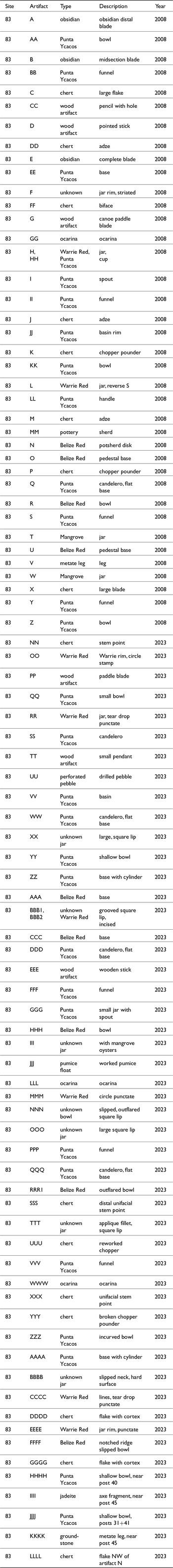
Sea-floor artifacts from the Ch’ok Ayin residential household group (Site 83). Artifacts A-MM were mapped in 2008. Artifacts NN-LLLL were mapped in 2023.

Brine-boiling jars, bowls, and basins with solid clay cylinder vessel supports (objects AAAA, EE, and QQ) are at the site (Figures 7, 8). They resemble those described for Stingray Lagoon and other sites in the lagoon, where a jar or bowl was supported by three solid clay cylinder supports over a fire (McKillop Reference McKillop2002:Figures 3.1, 3.10–3.14). The cylinders were placed at an angle in a glob of clay with a flat base (McKillop Reference McKillop2002:Figure 3.15). A glob of clay was formed over the top of the cylinder with a concave surface on which the pot rested (McKillop Reference McKillop2002:Figures 3.16–3.18). The recovery of a spout from large jar (I) and a small pot with a spout (GGG) at the Elon site suggests pouring brine into a dozen or more pots as the water evaporates with spouted vessels as at Sacapulas. Alternatively, the Maya at the Ch’ok Ayin site used calabash bowls such as those preserved in peat at Stingray Lagoon site and the Eleanor Betty site (McKillop Reference McKillop2019:130).
With a variety of bowl and jar vessel forms, some may have been used for brine boiling and others for hardening the loose, wet salt into salt cakes. At Sacapulas, a couple of dozen open bowls were used for brine boiling, with the bowls turned upside down to harden the salt inside the bowls, which were broken to remove the salt cakes (Reina and Monaghan Reference Reina and Monaghan1981). In some cases at Sacapulas, loose wet salt was poured into fiber or clay forms to make hardened cakes and then the pots were broken to reveal the hardened salt cake. That process results in broken vessels at the salt kitchens. In contrast, at a salt works on Bohol Island in the Philippines, brine was hardened in jars, and then transported in the same jars for regional exchange (Yankowski Reference Yankowski2019). In that case, the jars are absent from the production locale but instead found at the consumer locations.
Other objects made from locally available clay and temper materials not directly used in salt making were found at the Ch’ok Ayin site, including small incense burners or “candeleros” (Q, WW, DDD, and SS) and a burner lid (VV) from Building B (Figure 6).
Containers used to store brine and salt used in the brine-enrichment and boiling process include plain and decorated jars (Figures 8, 10). Warrie Red water jars are red-slipped, with some having incised, impressed, and “unit-stamped” decoration (using a tool to stamp a decoration) on the vessel shoulder. Defined for the Paynes Creek Salt Works (McKillop Reference McKillop2002:77–86, Figures 3.27–3.31), the technique of impressing designs from a stamp on Warrie Red resembles Remate Red from Lubaantun (Hammond Reference Hammond1975), Tinaja Red from Seibal and Altar de Sacrificios, and elsewhere (McKillop Reference McKillop2002:82–83). Warrie Red jars are found in Buildings A and B at the Ch’ok Ayin site and include the reverse “S” unit-stamp motif (L, Figure 10H ) and horizontal incised lines (H, BBB2, Figure 10a and 10d). Mangrove Unslipped pottery, defined for the Paynes Creek Salt Works (McKillop Reference McKillop2002:72–77, Figures 3.22–3.24), is an undecorated water storage jar, typically much larger than Warrie Red jars. There are several other jars (Figure 8a–d), including two in Building A (BBB1 and OOO), one in Building B (XX), and two in Building C (T and W). Artifacts T and W have square lips, which is a Terminal Classic trait. Another water storage vessel at the Ch’ok Ayin site is a large, striated jar with a square lip and outflared rim (F).

Belize Red pottery and ocarinas
Commonly found in residential households at Caracol and sites in the upper Belize River valley where it was made, Belize Red pottery was also found at the Ch’ok Ayin site and elsewhere at the Paynes Creek Salt Works (McKillop Reference McKillop2019:Table 7.2). Belize Red is easy to identify from the volcanic ash temper that creates a smooth and powdery surface, even with small fragments and weathered surfaces so that there were only traces of red slip (McKillop Reference McKillop2002:86–90, Figures 3.35–3.36). Belize Red is found outside Buildings A and B and in the open area between them (Figures 9, 11, Table 2). The vessels include a flat-bottomed bowl (HHH, Figure 11a), a sag-bottomed bowl with basal notching (FFFF, Figure 11c), a bowl (RRR1, Figure 11d), a pedestal base (O, Figure 11b), and a perforated potsherd disk with incised lines (location O, Figure 11e) near Building A. There is a Belize Red bowl with a plain basal angle (R) and another pedestal base (U) from the open area between Buildings A and B (Figure 9). There are a Belize Red body sherd with traces of red slip (AAA) and a Belize Red base (CCC) near Building B. Belize Red dates from the Late to the Terminal Classic at Caracol, with some traits temporally distinctive (Chase and Chase Reference Chase and Chase2012:8, Figures 2, 3). The large footed plate with outflaring sides, a sag bottom, is standard for the later part of the Late Classic (a.d. 550–800) at Caracol (Chase and Chase Reference Chase and Chase2012:Figure 2g). Toward the end of the Terminal Classic, small footed plates or bowls, including some with notched flanges and incised decoration, along with pedestal base bowls, come into use and were found at Caracol (Chase and Chase Reference Chase and Chase2012:8). The small collection of Belize Red sherds from the Ch’ok Ayin residential group includes forms that are generally Late Classic and that may continue into the Terminal Classic.
Map showing locations of Warrie Red and Belize Red ceramics. (Map includes LLL ocarina and LLL Warrie Red distinguished by symbols).


Ocarinas are figurine whistles found in household deposits for domestic ritual during the Classic period (Halperin Reference Halperin2014). They are common at some sites at the Paynes Creek Salt Works, notably Stingray Lagoon (McKillop Reference McKillop2002:Figure 3.39–3.40) and at Ek Way Nal where most are helmeted male figures or women with children (McKillop and Sills Reference McKillop and Sills2022:Figure 16). They resemble mold-made ocarinas produced at Lubaantun, where there are ocarina molds (Hammond Reference Hammond1975, Reference Hammond2017). There are four fragmentary ocarinas at the Ch’ok Ayin site. There are two ocarina fragments (MM and GG) in Building B, a fragment in Building A showing kneeling legs and a shield (LLL), and an elaborately dressed male figure (WWW) from Building A (Figures 8g, 9).
Stone objects
There are many stone tools, mainly associated with Building A and most made from chert (Figures 12, 13, Table 2). They include formal tools made from high-quality material with characteristic banding of the northern Belize chert-bearing region. The formal tools resemble artifacts from Colha (Shafer and Hester Reference Shafer and Hester1983). There are 11 chert objects associated with Building A. Most are along the exterior building wall, with two outside. J (Figure 13c) is to the northwest and SSS is to the southeast of the building. The Building A chert objects include three unifacial stemmed points (SSS, NN, and XXX, Figure 13a), two chert adzes (J and M), three chopper pounders (K, P, and YYY, Figure 13e), and flakes (C, DDDD, and GGGG, Figure 13f). A biface (FF, Figure 13b) is associated with Building B, a large blade likely part of a unifacial stemmed point (X) with Building C, and a chert adze (DD, Figure 13d) with Building D.
Map showing locations of stone artifacts.


Use-wear analysis of chert tools from other sites at the Paynes Creek Salt Works indicates most were used to process fish and/or meat and a minority to cut or whittle wood (McKillop and Aoyama Reference McKillop and Aoyama2018). The use-wear study also indicated that the morphology of the tools did not identify their use: for example, the pointed ends of unifacial stemmed points were unused, but the sides showed multiple use areas for cutting or scraping. More than salt making took place in Building A, which has evidence for woodworking and/or fish processing as well as use as a residence.
There are three obsidian blades, including two in Building A (object A and object E) and one in Building B (object B). E is a complete blade, visually identified to the El Chayal source in highland Guatemala. Object A is the distal end of a blade, visually identified to the Ixtepeque source. B is a mid-section of an obsidian blade, visually identified to the Ixtepeque source.
Other objects indicate fishing and domestic activities. Ground stone objects include a broken pumice fishing float (object JJJ), located just outside Building A to the southeast. There is a drilled pebble fishing weight (UU) outside Building C to the southeast. There is a fragmentary jadeite axe (IIII) from Building A. There is a metate leg (V) in the open area between the buildings. Metates are common in households at Maya sites, but they are also associated with salt production at Sacapulas (Reina and Monaghan Reference Reina and Monaghan1981), so their presence may support one or both uses at the Ch’ok Ayin site. At Sacapulas, corn was used in brine enrichment and in brine boiling. During the brine-enrichment process, when a drop of corn dough floated in the brine it was deemed sufficiently salty. Corn dough was added to the brine before pouring into the bowls to prevent the salt from sticking to the walls and to make the salt fine-grained.
Wood objects
Wood objects and building posts were preserved in the red mangrove peat matrix of the Elon site below the sea floor (Figure 14, Table 2). Parts of two wooden canoe paddle blades were discovered nearby one another on the west side of Building A (G) (McKillop Reference McKillop2019:Figure 6.15) and outside the same building (PP). A small carved wood pendant with a hole drilled at one end was discovered on the north side of Building A (TT). A small wood object shaped like pencil, with a hole drilled in the center (CC) was found near Building D.
Map showing locations of wooden artifacts. For descriptions, see Table 2.

Discussion
The type and distribution of objects associated with the wooden buildings at the Ch’ok Ayin site indicate that a variety of activities took place. The artifacts mapped on the sea floor were likely moved from their original use locations (see Binford Reference Binford1981; Schiffer Reference Schiffer1975). Sweeping material to the edge of rooms or outside may explain the concentration of artifacts in those areas in contrast to the center of buildings, especially for Building A. Artifacts may have been cached in the rafters along walls and then fallen to the floor, as described for the Ceren site that was covered by volcanic tephra (Sheets et al. Reference Sheets, Dixon, Lentz, Egan, Halmacher, Slotten, Herrera and Lamb2015). The concentration of artifacts with buildings in contrast to the paucity of material outside supports the interpretation that the activities that resulted in the artifact distributions took place nearby. The construction of the buildings and their use was at the same time, supporting the interpretation that the buildings were not used for refuse from earlier times.
The objects found in the buildings most likely reflect the activities that took place in and around those buildings, for several reasons: The diagnostic artifacts are similar. There are different types of artifacts associated with the different buildings that reflect different activities, supported by ethnographic models of salt production at Sacapulas and elsewhere (Reina and Monaghan Reference Reina and Monaghan1981). The Ch’ok Ayin site is isolated from other residential plaza groups and there are no artifacts in the intervening areas. Distinct patterns of artifacts on the sea floor at other lagoon sites also have defined building uses, including examples at Tab Nuk Na, Pok Tot, and Ek Way Nal. Excavations in building A at Pok Tot revealed 89 percent of the artifacts were briquetage from brine boiling, suggesting the activity took place in the building (McKillop and Sills Reference Sills2016), supported by the model of Sacapulas salt kitchens with separate residences.
The Belize Red serving bowls and ocarinas in Building A, along with other items typically found in Maya households, point to this building being a residence for the salt makers. Additional evidence for residential use is the perforated potsherd disk in Building A (N). The spindle whorl has incisions from spinning on the red slip (Figures 9, 11). The interior of Building A is empty, with objects along the exterior wall and under the roof overhang area 1–2 m outside the building. The residents of Building A kept the interior of the structure clean, since it was a living area. Any items stored in the rafters, on building posts, or on the wall fell when the building collapsed, resulting in the distribution of objects along the exterior walls, as described for the Ceren site (Sheets et al. Reference Sheets, Dixon, Lentz, Egan, Halmacher, Slotten, Herrera and Lamb2015). Broken bowls from fire-hardening salt at Sacapulas are stored inside the salt kitchens and then dumped outside the building (Reina and Monaghan Reference Reina and Monaghan1981). This may have been the case at the Ch’ok Ayin site. Most of the chert tools are outside Building A, suggesting their use outdoors, perhaps for fish or meat processing or for woodworking as indicated by use-wear study of other similar chert tools elsewhere at the Paynes Creek Salt Works (McKillop and Aoyama Reference McKillop and Aoyama2018).
Salt production was associated with the other buildings. Building C and Area D, lacking ocarinas and Belize Red pottery, were involved in salt production. Building C may have been a salt kitchen. The distribution of wooden posts and the occurrence of funnels in Area D suggest the area may have been used for brine enrichment. The number of funnels indicates that brine enrichment was a frequent activity at the Ch’ok Ayin site. The variety of Punta Ycacos vessels include large jars, bowls, and basins suitable for brine boiling. In addition, there are smaller bowls suitable for hardening wet salt into fire-hardened cakes for storage and trade.
The Late Classic Maya household at the Ch’ok Ayin site enriched the salinity of lagoon water, boiled the brine to make salt, and were engaged in other activities related to salt production and subsistence. The salt pots may have been made at Site 103, about 37 m to the north, where a wooden pottery-making paddle was found (McKillop Reference McKillop2019:Figure 6.5). The Maya at the Ch’ok Ayin site certainly communicated with salt makers at other household salt works, with a residence dated to the Late Classic at Ta’ab Nuk Na 330 m to the north. Sites 8, 69, and 70 have Late Classic Warrie Red and Belize Red pottery from the sea floor. The abundance of formal chert stone tools sets Ch’ok Ayin apart from the other household salt works in the area, with most of the chert from the residence, Building A. Although it is tempting to suggest the stone tools were used for processing fish, as elsewhere (McKillop and Aoyama Reference McKillop and Aoyama2018) and the spindle whorl from Building A used to spin cotton for fishing nets or lines, the stone tools may have been used for cutting wood and the spindle whorl for making cotton clothes. In any case, the number of formal chert tools in Building A indicates a focused activity using stone tools that did not occur elsewhere at the site.
The Maya at the Ch’ok Ayin site were able to obtain pottery and stone objects from diverse origins, indicating that the people were integrated into several economic production and distribution networks through regional marketplace trade. This was similar to the small Maya communities of Ceren in El Salvador (Sheets et al. Reference Sheets, Dixon, Lentz, Egan, Halmacher, Slotten, Herrera and Lamb2015), San Lorenzo and Chan No’ohol (Yaeger and Robin Reference Yaeger, Robin, Lohse and Valdez2004), Uxbenka and Ixkuku’il (Thompson and Prufer Reference Thompson and Prufer2021), or outlying areas of Caracol (Chase et al. Reference Chase, Chase, Terry, Horlacher, Chase and King2015). The Maya at the Ch’ok Ayin site had access to a wide variety of local and imported goods and resources, despite their low economic status as represented by the pole-and-thatch buildings constructed directly on the ground surface—buildings that would be “invisible” in the modern landscape of mounded remains of house mounds visible on lidar or traditional field survey. They extended to the south in the Guatemala highlands (for obsidian) and the Motagua River valley (for jadeite and greenstones). Economic ties extended north to the upper Belize River valley (for Belize Red pottery) and to the northern Belize chert-bearing zone with its main production locale at Colha (for formal chert tools). Economic ties also extended to inland locations in southern Belize for ocarinas, and perhaps farther inland to the Pasion and Petexbatun regions of Guatemala (for Warrie Red “unit-stamped” jars).
Radiocarbon dating places building construction at Ch’ok Ayin in the Late Classic, although the ceramics span a longer time, and extend into the Terminal Classic. The diverse forms of Belize Red are comparable to those dated throughout the Late and Terminal Classic at Caracol (Chase and Chase Reference Chase and Chase2012) and resemble forms found at Ek Way Nal in the East Lagoon at the Paynes Creek Salt Works (McKillop and Sills Reference McKillop and Sills2023). Shared unit-stamping motifs on Warrie Red and the presence of ocarinas also link the two sites. The presence of square lips and spouted jars at the Ch’ok Ayin site are Terminal Classic traits elsewhere.
Using the pole-and-thatch buildings provides an alternative for estimating population based on mound counts or residential groups, for which the Ch’ok Ayin site would have zero people. The Ch’ok Ayin site was a single-component residential household group with several buildings, including the Building A residence and other structures. They represented a household involved in surplus production of salt and related activities of an estimated five people. Using mound counts for the 100 sites with wooden architecture at the salt works (McKillop Reference McKillop2019) would indicate a population of zero. However, some sites have multiple wooden structures and not all buildings were constructed at the same time. Radiocarbon dating each of the 10 pole-and-thatch building at Ek Way Nal and Ta’ab Nuk Na sites indicated that different buildings were constructed at different times from the end of the Early Classic to the Terminal Classic (McKillop and Sills Reference McKillop and Sills2022, Reference McKillop and Sills2023). The type and variability of associated objects indicated the use of each building at these sites, which includes residences and workshops dated to different times. Future radiocarbon dating of each building at the Paynes Creek Salt Works would provide a better estimate of building construction dates upon which to base population estimates.
Conclusions
The Ch’ok Ayin residential group at the Paynes Creek Salt Works provides information on the Late Classic Maya domestic economy of what is regarded the lowest rank of Maya architecture—pole-and-thatch structures built directly on the ground surface. The outstanding preservation of wooden building posts at the salt works provides the only examples of Classic Maya pole-and-thatch architecture. The associated objects indicate one building was a residence, along with other structures used as salt kitchens, and outdoor activities. Far from being impoverished, the Ch’ok Ayin householders participated in the marketplace economy of the Late Classic southern lowlands, obtaining goods and resources from nearby and distant locations, including painted pottery, jadeite, and obsidian.
Sea-level rise during the Holocene flooded what was land between the current coast of Belize and the barrier reef. Hundreds of mangrove and sand cays developed in shallow water in the inshore lagoon. Maya settlement along the coast began by the Middle Preclassic (600 b.c.) at Ich’ak’tun, a shell midden at the mouth of the Deep River (McKillop and Robertson Reference McKillop and Robertson2019). Settlement and salt production at Cerros (Robertson Reference Robertson and Debra2016) began in the Late Preclassic (300 b.c.– a.d. 250), with the major stone architecture constructed later during the Late Preclassic. Moho Cay, a Late Classic trading port at the mouth of the Belize River, was inundated (McKillop Reference McKillop and Garber2004). Island sites with coral rock foundations of buildings in the Port Honduras in southern Belize flooded by sea-level rise include Wild Cane Cay, Frenchman’s Cay, Green Vine Snake, and Pelican (McKillop Reference McKillop2002:Table 5.3, 2005b, Reference McKillop2024). Settlement elsewhere along the coast of Belize and the Yucatan peninsula of Mexico impacted by rising seas includes Canbalam (Dahlin et al. Reference Dahlin, Andrews, Beach, Bezanilla, Farrell, Luzzadder-Beach and McCormick1998) and sites on the south coast of Belize that are hidden in the modern landscape (McKillop Reference McKillop2024). Only at the Paynes Creek Salt Works were the wooden posts from pole-and-thatch buildings preserved. Flooded coasts hold sites that are underrepresented in settlement studies, population estimates, and considerations of household livelihood. As sea levels continue to rise, low-lying coastal areas in the Maya area and beyond, worldwide, will disappear from the visible landscape.
Data availability statement
Data are available in the manuscript and by contacting the corresponding author.
Acknowledgements
The research is based on field research carried out in 2023, supported by NSF Grant 826653, with permits from the Belize Institute of Archaeology, and field assistance from Cher Foster and John Young.
Funding statement
The research was funded by NSF grant 826653.
Competing interests
The authors have no competing interests.


 Open access