Introduction
The Oer-IJ tidal system
Güray (Reference Güray1952) introduced and defined the Oer-IJ as the prehistoric tidal system between Castricum–Uitgeest, Beverwijk–Assendelft and Velsen–Amsterdam that was the forerunner of the IJ-Lake (Fig. 1). It was the successor of the Haarlem tidal system that had developed between Haarlem and Amsterdam in the early and middle Holocene (Van der Valk, Reference Van der Valk1992). Owing to the rapid Holocene sea-level rise, the western Netherlands had developed into one large tidal area in the Early Holocene, connected with the North Sea through a dozen tidal inlets (Beets et al., Reference Beets, Van der Spek and Van der Valk1994).
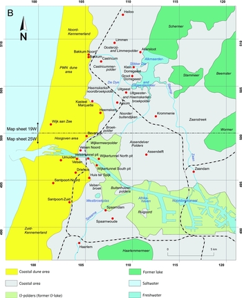
T Location maps with the topographic names mentioned in the text. A. The northwestern part of the Netherlands, with the location of the former IJ-lake and the silted-up tidal area of the Oer-IJ inlet system; B. Location map of the Oer-IJ region.

Between 4000 and 3000 BC the rate of sea-level rise decreased significantly (e.g. see the sea-level curve of Van de Plassche, Reference Van de Plassche1982), the tidal area in the western Netherlands filled up and large parts were transformed into peat bogs. The back-barrier part of the tidal inlet of the Haarlem system, which had moved northward over time (Van der Valk, Reference Van der Valk1992, Reference Van der Valk and Beets1996), was bounded on both sides by newly formed peatlands. After 3000 BC, when the main tidal channel was surrounded by peat bogs, the system changed in characteristic. The well-defined channels of this so-called Oer-IJ system drained the peatlands of Noord-Holland, the peat lakes of Flevoland (the area of the IJsselmeer, Markermeer, Flevopolder and Noordoostpolder, Fig. 1; Lenselink & Koopstra, Reference Lenselink, Koopstra, Rappol and Soonius1994) and those along the Eem River. Following the end of the Late Bronze Age (about 800 BC), the system was connected to the Rhine river farther south through the Utrechtse Vecht (Bos, Reference Bos2010). Through this connection, the Oer-IJ became the northernmost branch of the Rhine, changing into an estuary (the Oer-IJ Estuary) (Zagwijn, Reference Zagwijn1971a).
Earth scientific surveys and palaeogeographic reconstructions
After the Second World War, extensive regional earth scientific surveying was carried out in the Oer-IJ area. First, soil scientists mapped the areas Noord-Kennemerland (De Roo, Reference De Roo1953), southern Noord-Holland (Kloosterhuis, Reference Kloosterhuis1954; Pons & Kloosterhuis, Reference Pons and Kloosterhuis1955) and IJ-Lake (Güray, Reference Güray1952). Later in the 1950s, the National Geological Survey (RGD) started its systematic mapping, based primarily on coring surveys. Surficial-geological map sheets 19 West and East were published by Westerhoff et al. (Reference Westerhoff, De Mulder and De Gans1987). Map sheets 25 West and East were never completed, and only a concept surficial-geological map compiled by De Gans (RGD, unpubl.) is available for the associated area. This latter map was used by Blokzijl et al. (Reference Blokzijl, Dubelaar, De Gans and De Jong1995) for the popular-scientific geological map of Haarlem.
Within the framework of the geological mapping, palaeo-botanical/palynological research by Zagwijn (Reference Zagwijn1971b) and De Jong (Reference De Jong, Brandt, Groenman-Van Waateringe and Van der Leeuw1987a), and various geochronologic studies have produced valuable age control (see Appendices A1–A6). Useful information on the lateral variability of identified units has been obtained by studying temporary exposures of different dimensions. Large pits made for the construction of the Velsertunnel and Wijkertunnel (Van Straaten, Reference Van Straaten1957; Beets et al., Reference Beets, Roep, Westerhoff and Beets1996, Reference Beets, Groot and Davies2003) were invaluable in understanding the sedimentary mechanisms behind the Oer-IJ deposits. Much smaller exposures in the dunes and beach plains of Kennemerland, including key sites in the Hoogovens area, enabled Jelgersma et al. (Reference Jelgersma, De Jong, Zagwijn and Van Regteren Altena1970) to identify stages of dune formation, providing a context for preserved archaeology in the dune deposits. The most recent large-scale geo-landscape/geoarchaeological research in this area is based on observations in medium-sized pits (tens of metres) created during removal of redundant buildings and pumping stations in the dune area of the Water Supply Company Noord-Holland (PWN) in 2001 and 2002 (Vos et al., Reference Vos, Van Eerden and De Koning2010).
The first palaeogeographic maps of Noord-Holland, compiled on the basis of geological data, date back to the late 1950s and early 1960s, and were made by Pons and Wiggers (Reference Pons and Wiggers1959, Reference Pons and Wiggers1960). Zagwijn (Reference Zagwijn1971a) studied the origin of the Oer-IJ and produced five additional palaeogeographic maps, largely based on the geological map of the coastal area between Bergen and Monster, farther south in Zuid-Holland (Jelgersma et al., Reference Jelgersma, De Jong, Zagwijn and Van Regteren Altena1970), in which the mouth of the Oer-IJ was projected near Egmond. The palaeogeographic reconstructions of the Oer-IJ by Vos from 1983 also located the tidal outlet near Egmond, specifically during the Late Iron Age. From the geological mapping of sheet 19W it has appeared, however, that the mouth of the Oer-IJ was, in its final phase, located near Castricum–Bakkum (Westerhoff et al., Reference Westerhoff, De Mulder and De Gans1987). In his shoreline reconstructions Westerhoff also suggested that the Oer-IJ inlet formed between Uitgeest and Heemskerk around 2400 BC (between 4000 and 3500 14C years BP). In coastal reconstructions of the earliest period of the Oer-IJ, Van der Valk (Reference Van der Valk1992) showed that the Oer-IJ evolved from the earlier tidal inlet system of Haarlem between 3000 and 2400 BC.
More recent palaeogeographic maps of the Oer-IJ area (Vos, in Lange et al., Reference Lange, Besselsen and Londen2004 and Kok, Reference Kok2008; Vos et al., Reference Vos, Van Eerden and De Koning2010) are updates of the maps by Vos (Reference Vos, Brandt, Van der Horst and Stolp1983). The protocol followed in creating these maps, including scientific methods and expert considerations, has not been addressed, however, and an overview of the abundant multidisciplinary data used has not been provided. This paper fills that gap.
Palaeolandscape and archaeology
The prehistoric Oer-IJ region is particularly relevant from an archaeological perspective because it was one of the main settlement centres in the Netherlands (e.g. Meffert, Reference Meffert1998; Lange et al., Reference Lange, Besselsen and Londen2004; Kok, Reference Kok2008). Abundant natural water courses made the coastal area easily accessible and kept it well drained. Elevated barrier ridges and dunes were suitable for permanent occupation. The upper, silted-up parts of salt marshes and the margins of adjacent higher lying peatland were periodically inhabited.
The favourable palaeolandscape conditions explain the presence of humans and the multitude of archaeological remains in the shallow subsurface of the Oer-IJ area. Site-specific archaeological research was conducted in the Oer-IJ region, with Roman harbour works being surveyed in Velsen (Van Straaten, Reference Van Straaten1957; Morel, Reference Morel1986, Reference Morel1988), being addressed in the peaty marshlands of Assendelverpolders (near Assendelft; Brandt & Van der Leeuw, Reference Van der Leeuw, Brandt, Groenman-Van Waateringe and Van der Leeuw1987), and Iron Age and Roman settlements being discovered in salt marsh deposits excavated in Velserbroek (Therkorn & Oversteegen, Reference Therkorn and Oversteegen1994) and the nearby Broekpolder (Therkorn et al., Reference Therkorn, Besselsen, Diepeveen-Jansen, Gerritsen, Kaarsemaker, Kok, Kubiak-Martens, Slopsma and Vos2009). Highlights included the discovery of the early Medieval church of Assendelft on post-Roman peatland (Besteman & Guiran, Reference Besteman, Guiran, Brandt, Groenman-Van Waateringe and Van der Leeuw1987) and a canoe on the bottom of a tidal creek at Uitgeest-De Kleis (De Koning & Vos, Reference De Koning and Vos2007). Many archaeological studies provided key evidence used to improve and refine palaeolandscape reconstructions (see Appendices B1–B10). In the context of archaeological research, geological/palaeo-environmental studies by RGD, TNO and Deltares provided geoarchaeological information for palaeolandscape reconstructions and for understanding the relationship between habitation and landscape history. Key sites in the coastal dune area were the pits in the PWN dune area west of Bakkum/Castricum (Vos et al., Reference Vos, Van Eerden and De Koning2010) and in the Middensluiseiland Dam of the sluice complex in IJmuiden (Vos, Reference Vos2008). Beach-ridge sediments were exposed in excavations and construction pits of Klein Dorregeest (Vos, Reference Vos2007a; Müller et al., Reference Müller, Van Bergeijk, Drenth, Vos and Van Heeringen2008), Limmen-De Krocht (De Dijkstra et al., Reference Dijkstra, De Koning and Lange2006), and Assum and Waldijk (De Koning, Reference De Koning2007; Williams, Reference Williams2012). The pits of Castricum-De Zanderij (Vos, Reference Vos2007) and Uitgeest-Benes (De Koning & Vos, in prep.) provided valuable palaeolandscape information for the last marine phase of the Oer-IJ tidal area (for locations, see Fig. 1 and Fig. App. A).
For basic descriptions of the archaeology from the Late Neolithic up to the Late Middle Ages in the Oer-IJ area we refer, for example, to Lange et al. (Reference Lange, Besselsen and Londen2004), De Koning (Reference De Koning2007), Williams (Reference Williams2012), Müller et al. (Reference Müller, Van Bergeijk, Drenth, Vos and Van Heeringen2008), Vos et al. Reference Vos, Van Eerden and De Koning2010, Therkorn et al. (Reference Therkorn, Besselsen, Diepeveen-Jansen, Gerritsen, Kaarsemaker, Kok, Kubiak-Martens, Slopsma and Vos2009) and the dissertations of Therkorn (Reference Therkorn2004) and Kok (Reference Kok2008).
Methods
Geomorphology, subsurface geology and archaeology are the main pillars of palaeolandscape reconstruction for the Oer-IJ region, each with its own spatial and temporal strengths and weaknesses. Concerning the subsurface, a litho- and chronostratigraphic framework provides the context, whereas geological mapping uses the stratigraphic framework in creating logical and consistent visualisations of the distribution of stratigraphic units.
All landscape reconstructions presented in this paper are founded on combining a thorough, pre-existing geological framework with digital terrain models created using LIDAR images, with relevant information from key archaeological sites, and with absolute 14C (radiocarbon) and optically stimulated luminescence (OSL) age control. The geological map (Fig. 2) and LIDAR images of the Oer-IJ region (Fig. 3) constrain the spatial extent of geological features at and below the surface. Using absolute and relative (archaeological) age control on these features, the palaeolandscape was reconstructed in series of palaeogeographic maps. Absolute ages, available from publications and reports, are presented in Appendices A1–A6 (Fig. App. A) and the palaeolandscape information of the key sites in Appendices B1–B9 (Fig. App. B).
Geological map of the northern part of the Oer-IJ region (from Kok, Reference Kok2008). Numbers on the grid stand for kilometres in a national coordinate system (RD, Rijksdriehoek coordinates).


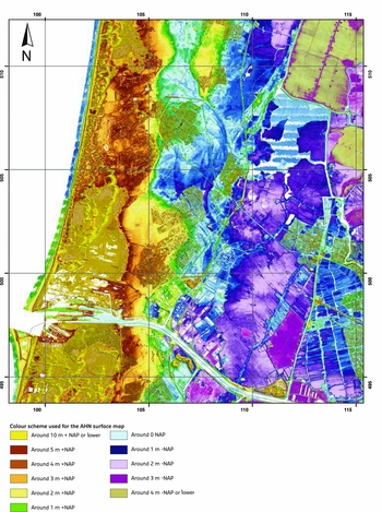
LIDAR-generated elevation map (AHN) of the Oer-IJ region.
Lithostratigraphy
The Holocene coastal deposits of the Netherlands are divided hierarchically into formations, members and layers. Clastic coastal deposits as dune, beach and tidal facies all belong to the Naaldwijk Formation (Westerhoff et al., Reference Westerhoff, Mulder, de, Geluk, Ritsema, Westerhoff and Wong2003; Fig. 4). The organic deposits accumulated in coastal-peat bogs belong to the Nieuwkoop Formation. The peat layer at the base of the Holocene coastal sequence – directly on top of the Pleistocene substrate – is called Basal Peat (Doppert, Reference Doppert, Ruegg, Van Staalduinen, Zagwijn, Zagwijn and Van Staalduinen1975; Westerhoff, Reference Westerhoff, Mulder, de, Geluk, Ritsema, Westerhoff and Wong2003). Peat layers underlain by Holocene clastic tidal deposits are called Holland Peat. On the landward side of the Oer-IJ system, a particularly thick layer of Holland Peat occurs. At its base, this peat is eutrophic (reed peat and reed-sedge peat). In the central parts of the area marked by thick Holland Peat, oligotrophic peat with recognisable remains of heather, peat moss and cotton grass covers the eutrophic peat. Woody peats have not been found in the Holland Peat around the Oer-IJ. However, twigs of shrubs are locally preserved. Myrtle, occurring in mesotrophic to oligotrophic peat, is one of the species identified. In the Assendelverpolders there is evidence that the peat was partly dehydrated as a result of the activity of prehistoric humans.
Holocene chrono- and lithostratigraphy of the coastal deposits in the subsurface of the Oer-IJ region.

In the study area, the following clastic members are distinguished within the Naaldwijk Formation (Fig. 4), from base to top:
Wormer Member: Tidal deposits between the Basal Peat and the Holland Peat, or between separate Holland Peat layers. Humic and lagoonal clays at the base of this unit are assigned to the Velsen Layer (Bennema, Reference Bennema1954).
Walcheren Member: Tidal deposits above the uppermost Holland Peat layer or, in the absence of Holland Peat, the Basal Peat (Vos, Reference Vos2015).
Zandvoort Member: Beach sands, usually below the dune sands of the Schoorl Member.
Schoorl Member: Coastal dune deposits with thin peat layers, including any humic soils.
Within the Schoorl Member, the classical distinction between Younger and Older Dunes (Doppert, Reference Doppert, Ruegg, Van Staalduinen, Zagwijn, Zagwijn and Van Staalduinen1975) has been kept in the new classification. The Younger Dunes consist of parabolic dunes with more relief than the Older Dunes. They locally exceed 10 m +NAP (the Dutch ordnance level, around mean sea level) and were formed largely after 1000 AD. The Older Dunes, generally not exceeding 6 m +NAP, contain (peat) soils and ancient culture layers in many places.
In this paper, the tidal sediments of the Oer-IJ system are referred to as Oer-IJ deposits. They belong to the Walcheren Member. Within the Oer-IJ deposits, different sub-units are distinguished on the basis of their sedimentary characteristics (lithofacies):
Subtidal channel and tidal-inlet deposits include sandy channel sediments formed below mean low water (MLW). They are layered and contain varying amounts of shells (partially in layers), (peat) detritus and clay (partially in laminae). The shell assembly consists largely of an open marine fauna, of which Spisula subtruncata (cut through shell) is the most important one.
Intertidal-flat deposits are dominated by sandy sediments, deposited between mean low and mean high water (MHW) levels. In their upper parts, these tidal-flat deposits are commonly slightly clayey and homogenised owing to bioturbation (mixing) by tidal-flat organisms. Downward the sands may be laminated with clay. The main shell species preserved in these facies and commonly found in life position are Scrobicularia plana (peppery furrow shell), Macoma balthica (Baltic tellin), Cerastoderma edule (common cockle) and Peringia ulvae (Laver spire shell; ‘Hydrobia’, in the older geological literature).
Upper-intertidal salt-marsh creek and supratidal-levee deposits are composed mainly of clays with some fine laminae of detritus and sand and/or silt. These deposits are sandier than adjacent salt-marsh deposits.
Supratidal salt-marsh deposits consist of grey organic clays, with the clastic component deposited at spring tides and/or during storms. Towards the peatlands of the Zaansteek, salt-marsh deposits become more humic (‘peaty’) and intensely rooted by reed. The salt-marsh clays fringing the coastal barrier, however, are lighter coloured and contain more silt and sand.
The names used for the various lithofacies are combined with the depositional system responsible for their accumulation (Oer-IJ), for example Oer-IJ channel deposits and Oer-IJ salt-marsh deposits.
The IJ-Lake deposits of the post Roman IJ-Lake between Amsterdam and Velsen include the fills of channels incised into Oer-IJ deposits, consisting of heavy humic clay and partially decayed organic material (peat chunks and peat detritus), and the clayey and sandy lake bottom lateral of channel fills. The sandy lake-bottom sediments in the vicinity of Velsen often contain peat detritus and are called the Dirty Sands (Bennema & Pons, Reference Bennema and Pons1957; Bosman, Reference Bosman2011).
Geological map and LIDAR images
Existing geological maps of Westerhoff et al. (Reference Westerhoff, De Mulder and De Gans1987) and Blokzijl et al. (Reference Blokzijl, Dubelaar, De Gans and De Jong1995) were supplemented and refined using LIDAR images of the land surface from the digital terrain model Actueel Hoogtebestand Nederland (AHN). On LIDAR images, the present-day surface expression of prehistoric Oer-IJ landscapes such as former main tidal channels and creeks in the clay-on-peatland (peat area covered thin clay layer of max. 0.5 m) can be recognised. Despite the intensive urbanisation, the morphological features are still visible over a large area (Fig. 3). Even the silted-up, closed sea-arm west of Bakkum, which was covered by Younger Dunes in the Middle Ages, is recognisable as these overlying dunes are lower here than to both the north and south.
Age control
Numerous samples from building pits, excavations, trenches of gas pipes and boreholes have been dated using 14C (on plant and shell material) and OSL (on silt and sand) (Fig. App. A). In one case (building excavation De Kleis in Uitgeest), dendrochonological analysis of an oak canoe found at the base of a tidal-channel fill was used for dating. An overview of hundreds of 14C dates and dozens of OSL dates, including their relevance to the palaeogeographic reconstruction of the Oer-IJ region, is given in Appendices A1–A6.
Archaeologically constrained ages are an important addition to absolute ages. Pottery provides an indication of the archaeological period in which it was manufactured, and offers the possibility of corroboration.
Palaeolandscape evolution
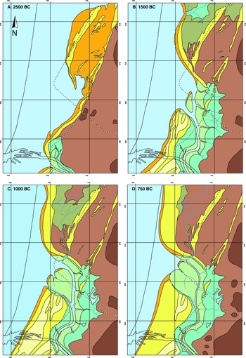
Using geological, morphological and archaeological information, the evolution of the Oer-IJ landscape is visualised in palaeogeographic maps at supra-regional and regional levels. At the supra-regional level, the maps (Fig. 5) show the entire Holocene coastal evolution of the northwestern Netherlands down to the Oude Rijn estuary in the lower-left corner. Regional maps of the Oer-IJ between Heiloo in the north and Velsen in the south (for extent, see Fig. 1) cover the period 2500 BC to 1000 AD (Fig. 6), and show the landscapes in and around the Oer-IJ from its inception to its final silting-up, as well as the formation of the IJ-Lake (Fig. 6). A reconstruction of beach ridge and dune progradation in the Oer-IJ region between 3500 BC and 500 AD, drawn on the basis of these maps, is shown In Fig. 7.
Palaeogeographical maps of the northwestern Netherlands between 9000 BC and present (revised after Vos et al., Reference Vos, Bazelmans, Weerts and Van der Meulen2011).


Palaeogeographical maps of the Oer-IJ region between 2500 BC and 1000 AD (revised after Vos et al., 2010).


Beach-ridge and dune formation in the Oer-IJ region between 3500 BC and 500 AD. For geological profile, see Fig. 10.

The history of the Oer-IJ system from a long-term supra-regional perspective
In the early Holocene sea level was around 35 m –NAP. The present-day Dutch coastal area and a large part of what is now the bottom of southern North Sea were dry (cf. Beets & Van der Spek, Reference Beets and Van der Spek2000). A remnant of the Overijsselse Oer-Vecht Valley in the middle of Noord-Holland (Fig. 5A) represents an ancient course of the Rhine River during the Saale ice age. Earlier the Rhine ran in a northwesterly direction to the North Sea, but the Saale ice front along the Wieringen–Gaasterland line deflected the course of the river westward. South of the ice front a new river valley formed and low contemporaneous sea level allowed the Rhine and its tributaries to deepen the valley significantly (Busschers, Reference Busschers2008). During the subsequent Eem interglacial and Weichsel glacial the primeval valley was partly filled with marine and terrestrial deposits (Westerhoff et al., Reference Westerhoff, De Mulder and De Gans1987). In the early Holocene, the Overijsselse Vecht, draining the eastern part of the Netherlands and part of Germany, debouched into this still considerable oversized valley, with the much larger Rhine following a more southerly course towards the Maas Estuary near Rotterdam (e.g. Busschers, Reference Busschers2008). The deepest part of the valley in the central part of Noord-Holland at the beginning of the Holocene was ~25 m –NAP. The later Oer-IJ was located along the southern edge of this valley. Here, the top of the Pleistocene surface, where it is not eroded by younger tidal channels, lies between 23 and 16 m –NAP (Westerhoff et al., Reference Westerhoff, De Mulder and De Gans1987).
Late Palaeolithic and Mesolithic hunters and gatherers likely encamped in this area, and archaeological remains possibly occur in the upper part of Pleistocene deposits, where not eroded by younger Holocene tidal channels (Van Heeringen & Theunissen, Reference Van Heeringen and Theunissen2001).
The geometry of the valley system had a strong influence on the drowning of Noord-Holland during the Holocene. The rapid sea-level rise in the early Holocene (Jelgersma, 1996; Van de Plassche, Reference Van de Plassche1982; Kiden, 2002) raised the water table in this palaeovalley, resulting in Basal Peat formation in a zone that showed an overall landward shift in time together with the landward-expanding open-water tidal basin (deposition of the Wormer Member) seaward of the peat landscape. In the PWN dune area, peat formation began around 7535 BC at about 23 m –NAP (B945–7; Table A3.20).
With continued sea-level rise, the peat area in the lowest part of the valley (25–20 m –NAP) was drowned around 7500 BC. Stratified humic clays of the lagoonal Velsen Layer continued to be formed in the PWN dune area, at least up to about 6720 BC (B45–6; Table A3.20). Near the Velsertunnel construction pit, where the top of the Pleistocene sand is at around 16 m –NAP, the Basal Peat was formed later, around 6085 BC (VT-5 and 6; Table A4.7); until shortly before that time lagoonal accumulation had taken place near the nearby located borehole Beverwijk-Wijkerbroek (WIJ-3; Table A4.8). The lagoons and coastal marshes were unsuitable for residential sites and camps, but fishing and hunting by Stone Age humans may well have been possible in these environments. No archaeological evidence of human presence in Noord-Holland during the early Holocene has been found yet. Artefacts found buried in the Maasvlakte area of the Port of Rotterdam (18.5–20 m –NAP), farther south, show that humans were present in the Dutch coastal lowlands during the early Holocene (Moree & Sier, Reference Moree and Sier2014).
Around 6500 BC the southern and northern North Sea became connected and the North Sea had grown to about its present size. The deepening of the North Sea and other changes in its bathymetry led to an increase in tidal amplitude along the Dutch coast (Van der Molen & De Swart, 2001; Hijma & Cohen, 2011). In the drowning Overijsselse Oer-Vecht system, increased tidal forces stimulated the formation of large tidal channels. At drilling locations B43 (B43–7; Table A3.18; Fig. App. A) and Wormer (BW-7 and 8; Table A1.2; Fig. App. A) the bases of channel fills date to around 5800–5700 BC. In the first half of the Atlantic, sedimentation could not keep up with rapid sea-level rise (Fig. 8), and an embayment arose, with tidal flats and associated tidal channels toward the landward basin margin (Van der Spek, Reference Van der Spek1994; Beets & Van der Spek, Reference Beets and Van der Spek2000; Beets et al., 2004; Fig. 5B).
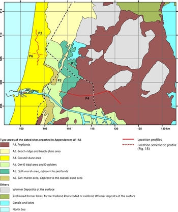
Geographical subdivision of the Oer-IJ region, with the location of the geological profiles p1 to p6.
Around 3850 BC the Overijsselse Oer-Vecht tidal basin had reached its maximum extent, enveloping almost all of Flevoland (Ente, Reference Ente, Koning and Koopstra1986; Lenselink & Koopstra, Reference Lenselink, Koopstra, Rappol and Soonius1994), while the location of the later Oer-IJ tidal system was still largely seaward of the contemporary coastline (Fig. 5C). To its south the tidal-inlet system of Haarlem extended all the way to present-day Amsterdam. The expansive tidal-basin landscape dominated by channels and sand flats was not suitable for habitation; unsurprisingly, no archaeological remnants have been found in the lower and middle part of the tidal deposits of the Wormer Member. Along the landward margins of this large tidal basin there is some evidence of occupation and habitation (5000–3400 BC) on creek ridges and Pleistocene sand outcrops near, amongst others, location P14 in the Noordoostpolder and near Swifterbant in the Flevopolder (Deckers et al., 1980; Raemaekers et al., 2010; Ten Asscher, Reference Ten Anscher2012).
After 3850 BC the embayment silted up gradually. Sediment from the sea and from rivers began to catch up and even exceed the accommodation space created by decelerating sea-level rise, resulting in a reduction of the tidal prism and a decrease in channel size and back-barrier tidal range (Van der Spek, Reference Van der Spek1994, Beets & Van der Spek, Reference Beets and Van der Spek2000). With the reduction of the tidal prism (the volume of water flowing into and out of the tidal basin during each tidal cycle) the wet cross-sectional area of the associated tidal inlet decreased (Oost & De Boer, 1994). As less sediment became needed to fill newly created space in the back-barrier environment, the landward migration of the shoreline stopped and the barrier started to prograde through beach-ridge formation (cf. Cleveringa, Reference Cleveringa2000). More and more of the tidal hinterland silted up to salt-marsh level (Vos & De Wolf, Reference Vos and De Wolf1988, 1994), falling dry for prolonged periods and enabling vegetation to colonise the surface. In Westfriesland and the Wieringermeer this salt-marsh landscape was inhabited (e.g. De Weerd, 1965; Van Heeringen & Theunissen, Reference Van Heeringen and Theunissen2001; Kleijne et al., Reference Kleijne, Brinkkemper, Lauwerier, Smit and Theunissen2013). Neolithic remains in the Amstel River deposits, found during the excavation of the North–South Metro Line in the old town of Amsterdam, are reworked and probably originate from this salt-marsh landscape as well.
The gradual silting-up of the embayment's tidal inlets and the infill of tidal channels strongly deteriorated the natural drainage of the hinterland, which became waterlogged and started to enable large-scale peat development between 3200 and 2500 BC (BN-2, Table A1.1; BW-2, Table A1.2; OM-1, Table A1.6; BK-1, Table A1.7; HO-1, Table A1.8; BH-1, Table A1.9; BII-1, Table A1.10 and MD-1, Table A1.11; for locations, see Fig. App. A). The central parts of the peatland became completely isolated from the sea, nutrient-rich water was no longer supplied, and oligotrophic peat formation and accumulation started. Near locations Neck (BN) and Wormer (BW) the oligotrophic peat formation began between 3000 and 2750 BC (BN-1, Table A1.1; BW-1, Table A1.2).
Around 3000 BC a relatively small tidal channel subdivided the large peatland that included both the Zaanstreek in the north and the Haarlemmermeer area in the south. The tidal system associated with this channel, known as Oer-IJ, continued to have an open connection to the sea because it provided the natural drainage of the surrounding peatland, including several peat lakes in the low-lying peat depressions in Flevoland (Lenselink & Koopstra, Reference Lenselink, Koopstra, Rappol and Soonius1994) and the Eem River (Fig. 5D).
After 2750 BC (Fig. 5D) the Oer-IJ drained all of the southern Flevoland peat hinterland and later – around 800 BC (Bos, Reference Bos2010) – also the Utrechtse Vecht region. The IJsselmeer area and the Noordoostpolder drained through the much larger Westfriese inlet system farther north, which formed the main remnant from the Oer-Vecht tidal basin. The two inlet-related tidal systems became separated completely by peatland (Lenselink & Koopstra, Reference Lenselink, Koopstra, Rappol and Soonius1994).
During the following centuries the progradation of the coastline accelerated, causing marine influence in the hinterland to dwindle even further. The reduced influence of the sea made Late Neolithic and Bronze Age settlement possible on the highest salt-marshes (Roep & Van Regteren Altena, Reference Roep, Van Regteren Altena and De Boer1988). Around 1750 BC, the Westfriese tidal system was still active (Vos et al., Reference Vos, Van der Heide and Stuurman2013), but after about 1500 BC the inlet silted up and the shrinking tidal basin was cut off from the sea upon complete barrier closure (Roep et al., Reference Roep, Beets and De Jong1979; Beets et al., Reference Beets, Roep, Westerhoff and Beets1996; Fig. 5E (note that these two publications report ages in non-calibrated 14C years BP, about 250 years younger than the calibrated 14C ages BC). As a result of the closure, the natural drainage of the Westfriese tidal system to the sea was impeded, the groundwater level rose in the area and large-scale peat growth started at the cost of a salt-marsh area that became increasingly saturated with water. The replacement of supratidal environments with peat bogs significantly reduced the possibilities for settlement in the Late Bronze Age and Early Iron Age.
As a result of the silting-up and closure of the Westfriese tidal basin after 1500 BC, a series of beach ridges developed between Limmen and Bergen, forcing the coastline to migrate seawards beyond its present position. The Middle Holocene embayment silted-up (Figs 5C–F) and due to this infilling also between Velsen and Beverwijk the beach ridges and dunes show a pattern of seaward coastal accretion (Fig. 7). The progradation of the coastline on both sides of the contemporary Oer-IJ mouth led to the development of a sandy tidal-flat area (the area between Castricum and Uitgeest), interpreted as an inner or flood-tidal delta by De Roo (Reference De Roo1953).
The connection with the Rhine River through the Utrechtse Angstel–Vecht system only emerged after 800 BC, when the peat lakes in the Vecht region became interconnected (avulsion process) and a continuous waterway between the Rhine and the Flevo lakes was created (Bos, Reference Bos2010). From south to north, the smaller lakes in the Vecht region were filled one by one with fluvial Rhine deposits. Through the new, northern connection, the Rhine eroded channels, incising the previously formed lake deposits and other underlying sediments, on its way to the Flevo lakes (Fig. 5F).
During that same period, West Friesland, the northern Flevo lake and the Overijsselse Vecht probably drained through a separate opening between the northern Flevo lake and the Wadden Sea. A ‘peat barrier’ separated the northern and southern Flevo lakes (Fig. 5F) until about 400 BC. The creation of a connection between the northern and southern Flevo lakes is considered to be the primary factor causing the silting-up of the Oer-IJ tidal area at that time. As a result all Flevo lakes and the rivers draining the Utrechtse Vecht region started to discharge through the new natural waterway towards the Wadden Sea. Now deprived of much of its water supply, the main channel of the Oer-IJ lost its discharge function. An abundant supply of marine sand by waves and tides drove the gradual closure of the Oer-IJ inlet (Vos et al., Reference Vos, Van Eerden and De Koning2010). This process was finalised between 200 and 100 BC when the barrier closed, thus isolating what remained of the Oer-IJ tidal system. Late Iron Age settlements in the former intertidal area between Castricum and Uitgeest (Castricummer Polder; Fig. 1) strongly suggest that there was no tidal activity anymore in this area at that time (Fig. 5G) and that the hinterland of the Oer-IJ system became fresh. The natural drainage direction reversed, with water moving through the channel of the Oer-IJ from Beverwijk to Amsterdam and onward into the newly formed Zuiderzee (Fig. 5G).
Increasing wave erosion and human activity along the old Oer-IJ channel during the Middle Ages led to the disappearance of marginal peatlands and to the creation of the IJ-Lake (De Gans & Bunnik, Reference De Gans and Bunnik2012; Fig. 5H). With the diking of the surrounding peatlands after 1300 AD, the enlargement of the lake was stopped (Fig. 5I, J). Sedimentation in the lake filled the part between Beverwijk and Assendelft. In 1872 the remaining parts of the lake were reclaimed and the IJ-Polders were created. The construction of the Noordzeekanaal in 1876 shortened the shipping route between Amsterdam and the North Sea, traversing the relatively narrow dune belt near IJmuiden (Fig. 5K).
Landscape and settlement history of the Oer-IJ region
The Oer-IJ existed for some 2800 years, from its inception around 3000 BC to the closure of its inlet around 200 AD. The landscape history of the region is visualised for eight successive periods (Fig. 6A–H), defined on the basis of coastal developments, marine activity and large-scale human interventions. Along with the maps, the most important palaeolandscape data (sample ages and relevant information from key sites in Appendices A and B) are discussed in light of the settlement history.
Formation of the Oer IJ: 3000–2000 BC (Fig. 6A)
The Oer-IJ tidal system is the successor to the Haarlem–Amsterdam system and developed around 3000 BC, when the tidal basins in Holland silted up. Because of the infilling the coastal-peat bog extended and the inlet system was sandwiched between the new peatlands to the north (Zaanstreek) and south (Haarlemmermeer area).
Around 3000 BC the mouth of the Oer-IJ system was located near Velserbroek (Van der Valk, Reference Van der Valk1992). Subsequently – due to the infill of the embayment of the central part of Holland and longshore currents – the associated tidal inlet shifted to the north, with low coastal dunes developing in the beach-ridge plain near Westerbroeksterplas (south of Velserbroek) (Bosman & Van Eerden, Reference Bosman, Van Eerden and Roos2009). About 2500 BC, the inlet and main tidal channel of the system were located just south of the present Noordzeekanaal – between Driehuis and Velsen-Zuid – as constrained from tidal-flat deposits near Huis ter Spijk (HS-1; Table A6.2; Fig. App. A) and at the Velsertunnel construction pit (VT-4 Table A4.7; Fig. App. A). At the location of the Wijkertunnel construction pits, salt marshes were present (Beets et al., 2004). Northeast of the northern pit of the Wijker-tunnel, a peat layer is still present on top of the Wormer salt-marsh deposits, pointing to a sheltered environment at the margin of the tidal system. The formation of freshwater peat in the whole area north of the Noordzeekanaal (A17 II-4; Table A5.7; Fig. App. A) indicates that at that time a beach ridge stretching from Velsen-Noord to Uitgeest–Akersloot protected this area, which allowed peat formation in this area.
Before 3000 BC a beach ridge had formed about 500 m farther west than the preserved landward-most beach ridge of Uitgeest. Peat formation in construction pit site Uitgeest-De Kleis at that time (Appendix B1; Fig. App. B) – on top of tidal deposits of the Wormer Member and below beach-ridge sediments of Uitgeest – point to a sheltered position and thus to the presence of a protecting barrier seaward of this location. The base of this peat layer dates from 3365 BC at De Kleis (UK-6; Table A2.1a) and from 3455 BC at the nearby gas pipe of Uitgeest (UG-1; Table A5.1). The top of the peat layer was formed at about 3040 BC (UK-5; Table A2.1a), providing a maximum age for the beach ridge at De Kleis. The landward side of the beach ridge is covered by a second peat layer that formed between 2530 BC and 2020 AD (UK-3 and 4; Table A2.1a).
Around 3000 BC openings in the beach barrier south of Uitgeest were still present, as witnessed by a clay layer (3455 BC, UG-1 and Table A5.1, to 3315 BC, BU-2 and Table A5.2) at the base of the Holland Peat in the western part of the Uitgeester- and Heemskerkerbroekpolders (Fig. 9). The age of the clay wedge in the western part of the Uitgeesterbroekpolder indicates that there was active exchange of tidal water between the North Sea band and the tidal basin until about 2600 BC. Fine sediment was supplied through small breaches in the Heemskerk–Assum–Uitgeest barrier. After 2600 BC, the barrier at this location was closed (Fig. 6A), with oligotrophic peat beginning to form (Fig. 9) in complete isolation from the sea.
Geological cross-section through the Uitgeesterbroekpolder, based on borehole descriptions from the DINO database of TNO. The profile demonstrates that the Early Age Creek deposits were formed in Bronze Age lake deposits (Ostracod clay). For the location of the profile see Fig. 8 (P1).

Breaches were also present north of Uitgeest. In prehistoric times the associated channel systems, such as the Stierop channel between Uitgeest and Groot Dorregeest, and the Slikker-Die channel between Klein Dorregeest and Akersloot, remained partially open. They played an active role in the drainage of the adjacent peatlands. The southern side of the beach ridge along the Slikker-Die palaeochannel was overgrown by peat (Müller et al., Reference Müller, Van Bergeijk, Drenth, Vos and Van Heeringen2008), which was formed between 2680 and 1615 BC (KF-3 and 4; Table A2.7).
Between 3000 and 2500 BC the orientation of the coastline changed. The beach ridge south of Uitgeest migrated landward over the Holland Peat of the site De Kleis while north of Uitgeest, the beach plain between Akersloot and Limmen expanded seaward. Bivalves from this prograding intertidal area, collected in the upper part of beach sands near Heiloo, Kooibrug and Nijenburgerviaduct, gave ages of 2375 BC (HO-1; A2.10), 2765 BC (KB-1; Table A2.11) and 2915 BC (NV-1; Table A2.12). Here, the aeolian sands covering the beach ridges started to accumulate between ~2500 and 2250 BC.
The beach ridge of Uitgeest–Akersloot was inhabited during this period, as witnessed by Bell Beaker finds (2500–2000 BC) on the eastern flank of the beach ridge near Klein Dorregeest (Appendix B2; Müller et al., Reference Müller, Van Bergeijk, Drenth, Vos and Van Heeringen2008). Near the Hoogdorperweg in Heemskerk, Late Neolithic/Early Bronze Age plough traces are present in the top of the beach-ridge unit (Appendix B3; Vaars, Reference Vaars2004). South of the Oer-IJ tidal inlet near Velsen, the beach-ridge area – with small sand dunes – near the Westerbroeksterplas (Velserbroekpolder) was also inhabited from the late Neolithic Period (Bosman & Soonius, Reference Bosman and Soonius1990).
Neolithic people were active in the tidal marshes along the main Oer-IJ tidal channel, as evidenced by a flint scraper and a sharpened pole found in the top of Wormer deposits at location Afrikahaven (below the Holland Peat; AH-4, around 3195 BC, Table A4.9).
Ingression of a tidal inlet south of Assum and formation of the ‘gooseneck’ tidal channel in the Noorderbuitendijken: 2000–1500 BC (Fig. 6B)
Shortly after 2000 BC, the continuous beach ridge between Heemskerk and Uitgeest was breached south of Assum. The changing coastline orientation had eroded and weakened the beach ridge at this location, as indicated by the formation of overwash sands in this area. The oldest overwash sands at site Waldijk II, linked to this breach, were deposited around 1950 BC (WA-O2; Table A2.3b). The washover may have acted as a sand source for contemporaneous and subsequent dune formation at Assum-Waldijk I (Appendix B4; De Koning, Reference De Koning2007).
The large, permanent ingression in the beach ridge, south of location Assum-Waldijk I, captured the tidal prism of the soon-to-be-abandoned inlet near Velsen-Zuid, creating a new Oer-IJ inlet about 10 km farther north and changing the course of the main tidal channel. This large channel incised into the (former) peatland of the Noorderbuitendijken area between Beverwijk-Heemskerk and the Assendelverpolders. It is likely that the breach formed during a major storm, linking to a drainage pattern that was already present in the peatland behind the beach ridge Beverwijk-Uitgeest. Owing to this ingression, around 2000–1900 BC, the main tidal channel of the Oer-IJ got its characteristic curved shape (‘gooseneck’), partly parallel to the North Sea coastline (Fig. 6B). Peatlands east of the channel were covered by Bronze Age clay layers. The old inlet (between Velsen Zuid and Noord) silted up shortly after the new breach formed. The tops of the beach sands at locations Velsen-Noordzeekanaal (VIa-1; Table A3.26b) and Velsen-PEN Noorderweg (VP-1; Table A3.23) are from about 2315 BC and 1700 BC, respectively. These dates indicate that the area of the old inlet filled up rapidly and dune formation started here.
Differential progradation of the coastline and development of the Oer-IJ Estuary: 1500–650 BC (Fig. 6C, D)
In this period, the coastline migrated seaward both north and south of the newly formed Oer-IJ tidal inlet. At the southern side, at the location of Hoogoven IV, the base of the dune sands – covering beach sands – had an age shortly before 875 BC (HIV-3; Table A3.21c). At that time the zone of beach ridges and dunes fronting the coast-parallel stretch of the Oer-IJ Estuary had already broadened to some 4 km and had extended northward to Kasteel Marquette in Heemskerk.
North of the new Oer-IJ inlet, between Limmen and Bakkum-Noord, the beach ridge and dune area migrated seaward as well, following the silting-up and closure of the Westfriese Inlet after 1500 BC. The Middle Holocene embayment of the coast of Noord-Holland was filled completely for this area between 1500 and 500 BC (Fig. 5C–E).
Owing to the coastal progradation south and north of the mouth of the Oer-IJ, the tidal area in between became larger, lengthening in a cross-shore direction. As the inlet shifted to Bakkum/Castricum, a large tidal-flat area developed in the Castricummerpolder around 1000 BC. This flood-tidal delta (De Roo, Reference De Roo1953), fronted by low storm ridges, was not the result of a passive marine transgression as assumed before (Pons & Wiggers, Reference Pons and Wiggers1959/1960), but of increasingly strong tidal currents through the lengthening inlet (De Groot et al., 1996).
The meandering Oer-IJ channel between Amsterdam and Velsen-Zuid deeply incised into the subsurface (De Gans, Reference De Gans and Bunnik2012) in the period that the tidal prism of the basin increased. Near Amsterdam, the base of the main channel fill is located at about 16 m –NAP. The maximum fill depth increases to about 24 m –NAP toward Spaarndammerpolder, and then decreases in the direction of the tidal inlet near Bakkum/Castricum. Near the construction pits of the Wijker- and Velsertunnel (Van Straaten, Reference Van Straaten1957; Beets et al., 2004) the inlet-proximal channel depth never exceeded 15 m –NAP. Close to the estuary mouth, in the PWN area near Castricum, it only reached max. 11 m –NAP (1000 BC time line in Fig. 10B; Vos et al., Reference Vos, Van Eerden and De Koning2010). Here, the channel was wider.
Cross-section through the mouth of the Oer-IJ system in the PWN dune system, after Vos et al. (Reference Vos, Van Eerden and De Koning2010). For the location of the profile, see Fig. 8 (P2). Key sites and boreholes in red are the new data from Vos et al. (Reference Vos, Van Eerden and De Koning2010). A. Geological profile (S–N) of the PWN dune area. B. Reconstruction of the time lines, based on 14C and OSL dates. The results of the dates are presented in Appendix A3.

The varying depth of the channel base is explained by subsurface lithology. Between Amsterdam and Spaarndammerpolder, the tidal deposits along the Oer-IJ channel were clayey and peaty, and much more cohesive than the sandy and therefore easily erodible layered deposits of the Wormer Member below the channel. In this area, the channel deepened rather than widened in response to increased tidal prism. Towards the inlet, the channel had sandy levees and widened rather than deepened. The history of this deepening and widening is unclear owing to a lack of data. Sediment fills from that period have been poorly preserved and few observations have been made.
In the transition zone, humic and peaty clays accumulated mostly under spring-tide and storm conditions in the supratidal reach. The humic peaty layers encountered in several Velserbroek cores have ages between 3525 BC and 85 AD (V2–1–6 and V3–1–3; Tables A6.3 and A6.4), showing that locally this zone remained in place for a long time.
North and northeast of the Oer-IJ channel, the transition zone between the salt-marsh area and the peatlands was located near the Buitenhuizer- and Assendelver Polders, and near Uitgeester- and Heemskerkerbroek. Peat formation in the Assendelver Polders began around 2775 BC (A17 II-4; Table A5.7) and continued until the Early Iron Age.
A salt-marsh clay wedge of a couple of decimetres in the Holland Peat 200 m south of location Q is estimated to have been deposited around 1500–1000 BC (Bronze Age). On top of the clay, eutrophic reed peat and oligotrophic peat was formed. The latter accumulated between 845 and 800 BC (AQ-4 and AQ-3; Table A5.10), associated with the temporary decrease in marine activity. A Bronze Age clay wedge of tidal deposits – covering the Holland Peat layer and deposited after the tidal-inlet ingression south of Assum around 1900 BC – is also found farther north in the Wijkermeerpolder, the Noorderbuitendijken and in the Uitgeester- and Heemskerkerbroekpolders. In these latter polders, a layer of eutrophic reed peat, several decimeters thick, is present between the Bronze Age clay (layer 4) and oligotrophic peat (layer 7; Fig. 9). The eutrophication of the peat and Bronze Age clay deposition are thus related to the breach of the beach ridge in this area.
Together with sea-level rise (10–15 cm/century), autocompaction of the peat under the weight of the newly formed clay layer certainly played a role in the temporary drowning of the peatlands in the Noorderbuitendijken, Uitgeester- and Heemskerkerbroekpolder.
Bowl-shaped depressions in the Bronze Age clay layer in the western part of the Uitgeester and Heemskerkerbroekpolders and Assendelverpolders (near site P; Vos, Reference Vos1998) contain humic ‘ostracod’ clay (Fig. 9), marked by abundant ostracods and Hydrobia snails. These depressions, with an erosive base, were brackish lakes in the transition zone between the tidal area and the peatlands. They were enlarged and deepened by wind–wave erosion. Hydrobia snails from site P have an age of 1310 BC (AP-1; Table A5.9).
Around 700–600 BC, the lakes had been filled to salt-marsh level. A reed level at the top of the Bronze Age clay layer formed around 685 BC (UB-1; Table A5.4.). More evidence that the lakes were fully filled by 650–600 BC is provided by the dated fills of salt-marsh creeks incised into the underlying ostracod clay (Fig. 9) during the subsequent phase of renewed marine influence.
From 850 to 650 BC marine activity in the Oer-IJ tidal system decreased and channels likely became shallower. Changes in tidal activity are distilled from observations in the transition zone between the tidally influenced landscape and the peatlands, such as around the Broekpolder and the Assendelver Polders. Oligotrophic peat at site Q (AQ-4 and AQ-3; Table A5.10) indicates that at least this marginal peat zone was no longer flooded by marine nutrient-rich water in the Late Bronze Age. Contemporary maximum flood levels in the tidal system had either decreased or the peat had grown to above extreme high water (EHW, or maximum stormflood level). Relatively limited marine activity during this time (lower EHW) is also reflected in the nature of pollen assemblages more north in the peatland of the Assendelverpolders at site A17 (De Jong, 1989). A period of decreased marine influence in the peatland, separating two periods of more prominent marine influence as represented by a local vegetation component with high amounts of Cheneopodi-caea (or goosefoot family): Chen. 3a peak of De Jong (1989) around 1230 BC (A17 I-3; Table A5.7) and Chen. 4 peak around 525 BC (A17 II-2; Table A5.7).
In the Broekpolder, the temporary reduction in tidal influence between 850 and 650 BC enabled humans to populate the area. Plough marks from the Late Bronze Age (Therkorn et al., Reference Therkorn, Besselsen, Diepeveen-Jansen, Gerritsen, Kaarsemaker, Kok, Kubiak-Martens, Slopsma and Vos2009) in salt-marsh deposits (layer III, Fig. 11; Appendix B5) date from around 790 BC (BP-7; Table A6.1). Land snails in this unit are an indicator of prolonged dry conditions (Vos, Reference Vos2000).
Profile reconstruction of the salt-marsh ridge, west of the main tidal channel of the Oer-IJ, Broekpolder location. For the location of the profile, see Fig. 8 (P3) and Fig. App. B5. For the description of the layers see Appendix B5.

In the Assendelver Polders the Early Iron Age settlement of site Q on top of the oligotrophic peat top (Therkorn, Reference Therkorn, Abbink, Brandt, Groenman-Van Waateringe and Van der Leeuw1987) dates the end of this peat formation and has an age of about 650 BC (AQ-1 and 2; Table A5.10).
It is difficult to explain the decrease in tidal activity in the Oer-IJ area during the Late Bronze Age. The changing dimensions of the Oer-IJ basin may have favoured dampening of the tidal amplitude, but the seemingly most important changes to its configuration took place well before the temporary reduction in marine influence. The flood-tidal delta between Castricum and Assum/Uitgeest that may have provided increased resistance to the incoming tide around 1000 BC, and the ‘gooseneck structure’ of the main channel between the Castricummerpolder and Velsen-Zuid, which might have slowed down the tidal activity (Kleinhans, pers. commun.), had been in existence since about 2000 BC. Positive feedback of peat development in intertidal areas is an alternative explanation, but there is no preserved evidence of this mechanism. Whatever the reason, lower tidal levels improved the living and working conditions in the higher margins of the main channel, as testified by the increased presence of humans during this relatively quiet period.
Active marine phase in the Oer-IJ Estuary: 650–400 BC (Fig. 6E)
Marine activity in the hinterland of the Oer-IJ increased once again in the Early Iron Age. Estuarine clay was deposited on top of oligotrophic peat along the eastern edge of the Uitgeester and Heemskerkerbroekpolders, and in the Assendelverpolders. A clay layer overlying the settlement at site Q (Vos, Reference Vos, Brandt, Van der Horst and Stolp1983) and the surrounding area indicates that drowning took place after 650–600 BC (AQ 1 and 2; Table A5.10). in addition, the lateral side of the beach ridge of Assum was covered with an Early Iron Age to early Middle Iron Age salt-marsh clay layer (layer Z3 in profile Fig. App. B4; De Koning, Reference De Koning2007).
On the northern side of the Assendelverpolders (site A17) a dated Cheneopodicaea peak in a sample from the marginal zone of the peatland indicates an increase in marine activity around 525 BC (Chen. 4; A17 II-2; Table A5.7). In the Broekpolder, Early/Middle Iron Age intertidal-flat deposits on top of salt-marsh units of the Late Bronze Age form another direct indication of increased marine activity (layer II, Fig. 11; Appendix B5). Scrobicularia plana shells from the tidal-flat sediments were formed between 600 and 345 BC (BP-2/6; Table A6.1). The widespread presence of Early Iron Age intertidal deposits on top of slightly older supratidal deposits indicates a regional increase in the MHW level (layer II, Fig. 11; Appendix B5). Other bivalve shells in the intertidal flat deposits formed next to the contemporary main channel also date from this period (WP-3, Table A4.4; NS-1, Table A4.5; BP-2 to BP-7, Table 6.1), confirming that the Oer-IJ was an open and active marine tidal system at that time.
The clearest indication that the tidal activity increased after 650 BC is the formation of creeks in the salt marshes in Uitgeester and Heemskerkerbroek, and in the Assendelverpolders. These creeks incised into the Wormer tidal deposits below, and their sediment fill consists of clays with thin sand layers. The hollowed-out oak canoe found at location Uitgeest-De Kleis at the base of the creek fill was made of wood that formed between 617 and 600 BC (UK-a1 to 4; Table A2.1b; outer and youngest part of the tree; Appendix B1). Assuming a maximum lifetime of the canoe of 25–50 years, the sediments directly below the canoe date from 550–590 BC. The minimum age of the creek incision – the beginning of the active marine period – therefore is estimated to be about 625–590 BC.
During the active marine period, the main tidal channel in the flood-tidal delta extended to the northern side of this area, near the present course of the De Dye (a remnant of the former tidal channel; Appendix B6), and by lateral migration of the channel the north bank of the Oer-IJ was eroded between Bakkum-Noord, Limmen and Uitgeest. The released overbank sands by channel erosion – in addition to aeolian activity due to reclamation activities (disturbance of the vegetation) of the adjacent beach ridges of Limmen – may have been the cause of the great sand drift east of the beach ridge of Limmen–Heiloo. The minimum available age of this event is around 765 BC (LK-6; Table A2.8), but there is probably a time hiatus between the end of the peat growth and the start of the sand drifts of about 150 years). Between Limmen and Heiloo sand was deposited over a large area on top of coastal peat that had formed in the beach-ridge plain at the present Oosterzij- and Limmerpolder.
During the increase in marine activity in the tidal hinterland of the Oer-IJ, the coastline on both sides of the tidal inlet continued to migrate seaward (Figs 6 and 7). South of the mouth, near Secundair 5, dune formation along the moving coastline began around 475 BC (S5-O2; Table A3.11b; Fig. App. B7) and north of the mouth, at Secundair E, starting around 410 BC (SE-O2; Table A3.6b).
There are different explanations for the increase in marine influence in the area of the Uitgeester and Heemskerkerbroekpolders, the Assendelverpolders and the Broekpolder after 650 BC, but none of them is fully satisfactory. A driving factor may have been the greatly increased fluvial discharge from the hinterland after the Utrechtse Vecht had become the northern branch of the River Rhine. The origin of the northern Rhine and Oer-IJ connection has been dated to around 800 BC (Bos, Reference Bos2010).
Amplified fluvial flow would have enlarged the tidal inlet and main channel of the Oer-IJ. Because of the wider opening of the inlet the friction effect decreased and this led to an increase in the tidal range in the estuary. An increase in the tidal range caused an enlargement of the tidal prism and this led again – a self-reinforcing process – to larger tidal channels and a decline in the friction effect at the mouth of the system.
Drainage of the peatlands of the Assendelverpolders during the Early Iron Age, through dug ditches, could have lowered the surface by peat oxidation and consequent subsidence. However, there is no evidence of intensive occupation of the area during the Early Iron Age.
Autocompaction, combined with some sea-level rise (approximately 10 cm per century at that time), is the most plausible explanation for creating accommodation space in the tidal system of the Oer-IJ. Deposition of clay on top of the peatlands during extreme high water would have triggered positive feedback, accelerating peat compaction under the weight of the clay cover. The subsequent increase in tidal volume would have enlarged the tidal channel, allowing the tide to penetrate farther into the estuary. In this self-reinforcing process of drowning, tidal flats and open water would have increased at the expense of supratidal peatlands.
Silting-up and final closure of the Oer-IJ system: 400 BC–250 AD (Fig. 6F)
Marine activity in the Oer-IJ Estuary decreased gradually after about 400 BC, when the self-reinforcing drowning in the Oer-IJ region ended and a reverse development started. Once sedimentation and peat formation took place faster than the creation of new accommodation space by relative sea-level rise, tidal channels were reduced in size, and peak tidal and storm-surge levels decreased. This process started around 400 BC, when the Flevo lakes became interconnected, thus linking the Oer-IJ region with the Wadden Sea. The ensuing reduction in the drainage function of the Oer-IJ formed the prelude to the closure of its North Sea inlet.
The pollen assemblage in the peat below the Roman settlement of site A17 in the Assendelverpolders (top peat formed at about 45 BC; A17 II-1; Table A5.7) and above the peat with the Cheneopodicaea 4 peak (signifying strong marine influence; formed around 525 BC; A17 II-2; Table A5.7) indicates that oligotrophic peat was being formed in the immediate vicinity (Therkorn et al., 1997) around this time. Humans took immediate advantage of reduced marine activity in the transition zone between the salt marsh and the peatland, as evidenced by the archaeological finds in the fill of a salt-marsh creek at site N (bone dating back to about 380 BC; AN-1, Table A5.8) and at location 9805-eastside in the northern part of the Assendelverpolders (RW III/G3a pottery type, which was in use between 400 and 250 BC; Van Roon, Reference Van Roon2000).
As the Oer-IJ silted up over the course of several centuries, its mouth (located in the PWN dune area) became significantly narrower and shallower. Radiocarbon and OSL dates from cores and pits in a north–south cross-section (Fig. 10) traversing the former mouth show that by 400 BC the southern part of the estuary up to Sec. G had already been cut off from the sea by a beach ridge (see Tables A3.5/A3.20; Appendix B7).
Around 200 BC the Oer-IJ system definitively lost its westward connection to the sea when the frontal beach ridges bounding the estuary merged to form a continuous barrier. Tidal activity in the former inlet fully ceased during the last half of the Late Iron Age and the whole area, including the sandy flood-tidal delta of the Castricummer Polder, became permanently habitable. The Late Iron Age sites (settlements) found on top of the youngest Oer-IJ tidal deposits in this polder are testament to this change (Appendix B6). At sites Uitgeest-Benes (Fig. App. B6; De Koning, in prep.), Castricum-Grote Ven, locations A and B (Woltering, Reference Woltering1977; De Koning, 2013), Late Iron Age pottery and traces of settlements were found in archaeological trenches and newly dug ditches. The Iron Age pottery found is typical for the period between 200 BC and 50 AD. At site Uitgeest-Benes, the sand layers in which the settlement and ditches were constructed were dated. A storm layer (sand with open-marine shell species, including Spisula subtruncata) and an overlying aeolian sand layer – directly on top of it – have overlapping 14C-age intervals. Both formed around 220 BC (UB-O1 and 2; Table A4.11b). The upper part of the underlying intertidal sand-flat deposits was dated using two specimens of the bivalve Scrobicularia plana, which provided ages of about 390–285 BC (UB-3 and 4; Table A4.11a). These tidal-flat deposits were formed during the active marine phase of the Oer-IJ, as to be expected, and the aeolian cover sand layer was formed in the first half of the Late Iron Age. The age of the dune sand (the last non-aquatic sedimentation at this location) fits well with the associated Late Iron Age occupation.
Late Iron Age settlements were also present in the dry salt marsh and marginal peatlands along the beach ridge of Uitgeest (Helderman, Reference Helderman1970; De Koning, Reference De Koning, Grünewald and Seibel2003, Reference De Koning and Hogendijk2012) and salt-marsh areas in the Uitgeester- and Heemskerkerbroekpolders (Therkorn, Reference Therkorn2004), in the Assendelver Polders (Brandt et al., Reference Brandt, Van der Leeuw, Brandt, Groenman-Van Waateringe and Van der Leeuw1987; Therkorn et al., 1997) and in the Broekpolder (Therkorn, Reference Therkorn, Besselsen, Diepeveen-Jansen, Gerritsen, Kaarsemaker, Kok, Kubiak-Martens, Slopsma and Vos2009). In the margins of the peatlands, peat growth stopped near Late Iron Age settlements because of drainage and exploitation of the land, while at some distance from these sites peat growth continued. Because the peat was no longer inundated by nutrient-rich water, oligotrophic Sphagnum peat began to dominate. This peat was extracted in the Roman Period in elongated strips (Therkorn et al., 1997) and used as fuel and building material.
Around 0 AD the seaward edge of the closed barrier between IJmuiden and Egmond was still located well landward of the present coastline (Fig. 7), but seaward of the Hoogovens construction pits. Here, 3 km landward of the present-day coastline, the start of dune formation on the beach sands took place some time between 875 and 545 BC, around the transition from the Bronze Age to the Early Iron Age (HIII-6; Table A3.21b; and HIV-3; Table A3.21c).
In the Early Roman Period the lower parts of the barrier were still occasionally flooded during extreme storms, with large amounts of overwash sands and shells being deposited behind gaps in the frontal dune. These storm deposits were found at the locations Pompgebouw and Castricum-Zanderij. OSL ages of sand layers above and below the storm unit at Castricum-Zanderij indicate that the overwash deposit formed at the end of the second century AD (CZ-O1 and 2; Table A4.3b; Appendix B8).
On barrier closure during the Late Iron Age, the Oer-IJ Estuary could no longer drain directly to the sea. Between Velsen and Amsterdam the main Oer-IJ channel remained open (time of the beginning of the infilling of the channel/IJ-Lake formation) as the natural drainage was forced in the opposite direction to the Flevo lakes (early Zuiderzee) and Wadden Sea area (Fig. 5G). Because the waterway between Velsen and Amsterdam still existed at 50 AD, the Roman harbour at Velsen maintained a good connection with the Oude Rijn, the Roman border (Limes) at that time, through the Amstel and Utrechtse Vecht rivers.
As a result of the long water-discharge route through the Flevo lakes to the Wadden Sea, the drainage of the Oer-IJ area deteriorated, and the groundwater level in the silted-up salt marshes of the Uitgeester- and Heemskerkerbroek and Assendelverpolders rose. In the second and third centuries AD people adjusted to the rising water table by constructing plank bridges between their houses. As wetlands expanded, widespread post-Roman peat growth started, and people abandoned the area at the end of the third century AD.
Coastal progradation and peat formation in the Oer-IJ hinterland: 250–950 AD (Fig. 6G, H)
After 250 AD, large-scale peat development took place in much of the Oer-IJ region behind a widening belt of dunes, reflecting continued deterioration of the natural and artificial drainage. In the Broekpolder, west of the abandoned main tidal channel (BP-1; Table A6.1), newly developed peat in the lower parts of the former tidal area was eutrophic. In the former peatland areas of the Uitgeester- and Heemskerkerbroek Polders and Assendelverpolders predominantly oligotrophic peat developed (AR-1 up to 5; Table A5.5; Fig. 12). Because of the large-scale peat formation, the habitation opportunities in these areas decreased markedly, and no archaeological remains from the late third to the 10th century have been found here.
Profile reconstruction of the rise and decline of the peat land in the Assendelverpolders and Zaanstreek. For the location of the profile, see Fig. 8 (P4).
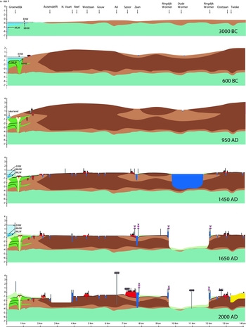

Peat formation continued into the Early Middle Ages, and the central parts of peat domes reached elevations of at least 3–4 m +NAP (Fig. 12). In the 10th century the first peat extraction in central Noord-Holland began along the ditch known as The Kaaik, which is located west of the present village of Assendelft (Besteman & Guiran, Reference Besteman, Guiran, Brandt, Groenman-Van Waateringe and Van der Leeuw1987). A simple wooden church made Assendelft the first parish in the Zaanstreek (Fig. 13).
Mediaeval church of Assendelft from the 10th century AD in its 10th-century AD environment. A. Image from Mieneke van Gogh of the wooden church of Assendelft; B. Remnants of the graveyard around the excavated mediaeval church of Assendelft. Below the 0.4 m thick clay cover only the bottom plates of the coffins were preserved. About 1.2 m of peat has disappeared by oxidation. The height of the coffins was ~0.4 m and the depth of the grave ~1.2 m.

In the Assendelverpolders, post-Roman peat is still present below the site of the 10th-century church of Assendelft (Figs 12 and 13). The weight of the church compacted the post-Roman peat, preserving the overlying culture layer. The age of the peat directly below the culture layer indicates that peat formation continued until the ninth century (AO-1; Table A5.6).
Post-Roman peat was also found below the IJ-Polder clay near Ruigoord, where peat development also continued certainly into the ninth century (RZ-1; Table A1.3) and possibly even longer since the original top has been eroded (Veerkamp, Reference Veerkamp2001).
In the Castricummer- and Heemskerker Noordbroekpolder eutrophic peat was formed during the Early Middle Ages in depressions and silted creeks (Delgronden; De Roo, Reference De Roo1953). The highest sand flats and lower dunes in this area were probably never covered by peat. Habitation was likely limited to these higher locations (e.g. Uitgeest-Benes; App. B6; De Koning, in prep.), where humans were present during the Early Middle Ages. Settlements from this period have also been found on higher sandy areas in the PWN dune area (Duinker, Reference Duinker1955; Deelen, 1962; Van Regteren Altena; Reference Van Regteren Altena1970; Vos et al., Reference Vos, Van Eerden and De Koning2010), and on the beach ridges of Limmen–Heiloo (Dijkstra et al., Reference Dijkstra, De Koning and Lange2006; Dijkstra & Verhoeven, Reference Dijkstra and Verhoeven2013) and Akersloot–Dorregeest–Uitgeest–Assum (De Koning, Reference De Koning1992, Reference De Koning, Grünewald and Seibel2003, 2007/2012).
The abandoned deep Oer-IJ channel between Amsterdam and Velsen was oversized for local drainage. As a result, clay was deposited in the channel thalweg starting in Roman times (Cleveringa, Reference Cleveringa1988). The channel fill postdating 800 BC contains much organic material, even as blocks of peat (De Gans, 2008), indicating that peat was eroded along the channel margins. As part of this process, the channel became both shallower and wider. An elongated lake began to form, the early phase of the later IJ-Lake. Continued erosion caused the lake to expand in time.
In the meantime, the coastal dune area widened. Periods of local sand drift, contributing to the formation of the Older Dunes, alternated with periods of vegetation and soil formation. Generally, the dunes were several metres high, with a maximum elevation of about 6 m +NAP. In the studied pits and trenches in the PWN dune area (Appendix B7), and at the Hoogoven location (Jelgersma et al., Reference Jelgersma, De Jong, Zagwijn and Van Regteren Altena1970) and Middensluis-eiland (Appendix B9), the exposed dune profiles show one or more light brown to black palaeosols, with thicknesses varying from a few centimetres to a couple of decimetres. These soils are humic to very humic or even peaty. Even the peaty soils are sandy or contain thin sand layers, indicating that some aeolian sand transport continued in the area during periods of vegetation. Plough marks and hoof imprints of cows occur in many places in the palaeosols (Appendices B7 and B9). Anthropogenically reworked soils are termed ‘culture layers’.
Multiple organic-rich layers were especially well-developed at sites Secundair 5, Secundair G and WRK in the PWN dunes (Tables A3.9–A3.11; Appendix B7) and at Middensluiseiland (Table A3.4; Appendix B9; Fig. 14), separating sand-drit units formed as little as a century apart. The palaeosols are intensively ploughed, suggesting that the disturbance of the vegetation by humans was a major factor in the local sand drift and dune formation. Only in the dune profile of pit Secundair 3 was no organic palaeosol found. This site is located in the convex cove of the former Oer-IJ mouth where the formation of Older Dunes started relatively late.
Landscape reconstruction for profile Middensluiseiland. For the location of the profile, see Fig. 8 (P5) and Fig. App. B9. The vertical exaggeration of the profile is 5. For the location of the profile sections 1 to 20, see Fig. App. B9.


The Older Dunes landscape became intensively populated and used as soon as it was formed, as testified by many archaeological indicators and artefacts from the pits and trenches in the Hoogoven (Van Regteren Altena, Reference Van Regteren Altena1970) and PWN dune areas (e.g. Secundair E, Secundair D, Secundair G, WRK gebouw and Secundair 5; Vos et al., Reference Vos, Van Eerden and De Koning2010). The Older Dunes are mostly covered by Younger Dunes sand accumulated during the next phase, keeping the greater part of the incorporated archaeological heritage both ‘invisible’ and preserved.
Formation of the Younger Dunes and large-scale reclamation of the peatlands: 950–1800 AD
From the 11th century onwards the whole peat area of the Zaanstreek was reclaimed, and peat villages such as Westzaan, Oostzaan and Zaandam arose (De Cock, Reference De Cock1980). For these reclamations peat was drained on a large scale, lowering bog surfaces significantly through oxidation and compaction. High-lying, well-drained peat areas remained arable until about 1400 AD. By 1450 AD the surface level had become so low that drainage problems arose. It became increasingly difficult to discharge excess water into the IJ-Lake, and the area turned into a wetland suitable for livestock only. Peat lakes began to form along bog streams such as the Wormer peat river during the Late Middle Ages. Owing to wave-governed shore erosion and extensive peat extraction by humans, many of these lakes expanded quite rapidly. The IJ-Lake also increased in size, reaching its maximum extent in this period. Continued drainage caused the surface level of the remaining peatlands to be lowered further and they sank around or below the 0 NAP level (Figs 12D, E). Thus, at high tide the open water of the IJ-Lake stood at a higher level than the peat surface. Dikes protecting the area against flooding broke repeatedly. At each breach location erosion pits were scoured and clay was deposited on the adjacent peat. Clay was also deposited by ‘inland water’ (water inundations in the polders behind the sea dike) when low parts of the embanked areas were flooded. Sluicing excess water during low tide in order to keep the polders dry became more and more difficult as the difference between polder levels and open water, such as the IJ-Lake, increased. From the 17th century onwards windmills had to be used. They also became instrumental in reclaiming peat lakes such as the Wormer.
In the dune area of the western Netherlands, the mode of aeolian sand transport changed drastically between 950 and 1050 AD. Enormous quantities of sand went adrift, forming large parabolic Younger Dunes. In the PWN dune area they reached up to 25 m +NAP. Ages of peat and sand from pits and trenches at Middensluiseiland and in the PWN area confirm that the formation of the Younger Dunes in this region began at the end of the 10th and the beginning of the 11th centuries (ME-3 and 4, Table A3.4a; SE-O1, Table A3.6b; WRK-1; Table A3.10a; S5–1, Table A3.11a), in line with the regional timing (Jelgersma et al., Reference Jelgersma, De Jong, Zagwijn and Van Regteren Altena1970). Possible driving mechanisms were sand availability in response to strong coastal erosion (Van Straaten, Reference Van Straaten1965; Jelgersma et al., Reference Jelgersma, De Jong, Zagwijn and Van Regteren Altena1970; Van der Valk, Reference Van der Valk1992), changing climate (increasing storm activity, e.g. Ehlers, Reference Ehlers1986) and human influence (Van den Berg, 2013). Palynological and faunal proxies provide evidence for relatively warm and dry conditions around 1000 AD (Klijn, Reference Klijn1981; Van den Berg, 2013), which would have promoted aeolian sand transport. Increased storm frequency (Ehlers, Reference Ehlers1986) was another relevant climatic change. Observations in the pits of Middensluiseiland (Vos, Reference Vos2008) and the PWN dune area (Vos et al., Reference Vos, Van Eerden and De Koning2010) show that human interference in the dune landscape was large (e.g. ploughing) and definitely played an important role in aeolian sand transport. At the end of the Early Medieval Period humans disturbed the vegetation on a large scale, at least helping to set off a self-enhancing process of aeolian sand transport that culminated in the formation of large parabolic dunes (Klijn, Reference Klijn1981). The importance of each of these processes and the ultimate driving (decisive) factor in the formation of the Younger Dunes remains a point of discussion.
Below the highly accidented parabolic dunes, horizontally layered aeolian deposits level the former relief of the Older Dunes. As the parabolic dunes (also known as ‘walking dunes’) migrated, the tops of the Older Dunes were flattened by wind erosion (‘equalisation phase’; Jelgersma et al., Reference Jelgersma, De Jong, Zagwijn and Van Regteren Altena1970; Pruissers et al., Reference Pruissers, Vos and Van der Valk1991; Van der Valk, Reference Van der Valk1992) and many of the intermediate dune valleys were filled with aeolian sand (Fig. 14C–E). In the predominantly horizontal deposits from this equalisation phase some thin organic beds occur locally, formed in the broad plains between the parabolic dunes. At Secundair 5 and near the WRK building such thin organic layers were found to have formed around 970 AD (S5–1; Table A3.11a; WRK-1; Table A3.10a). The overall pattern of the parabolic dunes dates for the major part from before the 16th century. In subsequent times, local sand drift has still taken place, but the general dune morphology, as seen on the AHN elevation map (Fig. 3; yellow parabolic shapes), has not changed since then.
The AHN terrain map shows clear evidence for migration to the northeast, reflecting prevailing southwesterly winds. In light of this parabolic orientation of the dunes (indicative for SW–NE aeolian transport), it is likely that the present-day Papenberg dune migrated over the site of the construction pits at Secundair 5, the WRK Building and Secundair G, and equalised the former relief of the Older Dunes in the process, during the transition from the Early to the Late Middle Ages.
The Younger Dunes buried Early Medieval settlements in the area. Humans continued to be present in the dune area but the habitation was increasingly concentrated in villages along the landward side of the widening dune belt. Archaeological traces or materials have not been found in deposits from the equalisation phase, and are few and far between in the sand forming the Younger Dunes.
Urbanisation and formation of a ‘sand dike’ in the coastal zone: 1800 AD–present
Before 1800 AD the frontal dunes fringing the contemporary coastline were still highly mobile, reflecting their parabolic origin. Intermittent lows were prone to flooding during major storms, locally transforming into ephemeral or permanent tidal inlets (known locally as slufters). Since the 19th century the coastline has changed strongly. For coastal defence, sand transported along the coastline was captured with fences, and the captured sand was fixed by planting marram grass (Klijn, Reference Klijn1981). The most seaward interdune areas were filled with wind-blown sand, creating a single frontal dune. The current coastline of the western Netherlands is fringed by a high and straight, commonly vegetated dune ridge. Because of its anthropogenic genesis, it is frequently referred to as a ‘sand dike’ (Fig. 15D, E).
Landscape reconstruction for the profile through the PWN dune area and present-day examples of the reconstructed features. The vertical exaggeration of the profile is about 60. A. Reconstruction for the Roman Period; B. Embryo-dune formation (De Hors, Texel; photo Laura Vonhögen); C. Lower-dune formation (De Hors, Texel; photo Laura Vonhögen). D. Present situation; E. ‘Sand dike’ (Heemskerker beach; photo Marcel Bakker); F. Vegetated parabolic dunes in the Younger Dune area (De Hors, Texel).


In the 19th century the major change in the landscape behind the dunes was the reclamation of the IJ-Lake, immediately followed by the construction of the Noordzeekanaal (Fig. 5K), traversing the new IJ-Polder and the dune belt to connect Amsterdam with the North Sea. The reclamation and drainage of the IJ-Polder and other polders by engine-driven pumping stations has gradually lowered the surface level of the peat polders to 1–2 m –NAP (Fig. 12; reconstructions 1650 and 2000 AD).
Large-scale urbanisation in the 20th century rapidly changed the landscape in the Oer-IJ region. Although these changes have obscured and obliterated more and more of the natural landscape, they have also allowed geo-archaeologists to study former landscapes and their inhabitants in unprecedented detail (key-site information and AHN elevation map; Fig. 3).
Discussion
New insights into key events
Our research confirms that the change in the position of the Oer-IJ tidal inlet was not caused by gradual migration driven by longshore currents, as was suggested in the reconstructions by Vos (2004) and Vos et al. (Reference Vos, Van Eerden and De Koning2010), but rather the result of a breakthrough event, as indicated in the reconstruction of Van der Valk (Reference Van der Valk1992, Reference Van der Valk and Beets1996). The associated ingression was created around 2000–1900 BC, some 500 years later than suggested in these latter publications.
There has been disagreement on the timing of the development of the Zuiderzee. In his palaeogeographic maps, Zagwijn (1986) placed it not before the Early Medieval period (after 400 BC). Pons & Wiggers (Reference Pons and Wiggers1960), Ente et al. (Reference Ente, Koning and Koopstra1986), and Westerhoff et al. (Reference Westerhoff, Mulder, de, Geluk, Ritsema, Westerhoff and Wong2003), however, concluded that the connection of the Zuiderzee with the Wadden Sea was established in the Early Roman period (about 50 AD). They based their opinion on landscape descriptions by the Roman writers Tacitus and Plinius, and on the assumption that the other opening to the sea – the Oer-IJ – would have silted up simultaneously (Ente, Reference Ente, Koning and Koopstra1986). Lenselink (in Lenselink & Koopstra, Reference Lenselink, Koopstra, Rappol and Soonius1994; Menke et al., 1998) proposed a narrow connection between the Flevo lakes and the Wadden Sea in the Late Iron Age (before 0 AD).
Here, we argue that the connection of the Flevo lakes and the Wadden Sea was established even earlier, in the Middle Iron Age. Silting up of the Oer-IJ started around 400 BC, caused in part by the creation of the Zuiderzee opening.
The common opinion (e.g. Zagwijn, 1986; Morel, Reference Morel1988; Bosman, Reference Bosman1997) was that in the Early Roman period the Oer-IJ still had an open connection to the North Sea. Between 15 and 50 AD Roman ships could supposedly still navigate from the port of Castellum Flevum to the open sea. However, geological and archaeological evidence argues against such a late open connection. Dated Oer-IJ sediments in the former mouth and tidal hinterland indicate that the opening had been already closed in the Late Iron Age. Just landward of the mouth of the Oer-IJ, the base of dune sands on top of marine tidal deposits dates from around 220 BC. Nearby, Late Iron Age settlement traces were found on top of Oer-IJ-tidal deposits. Clearly, the Oer-IJ system had been cut off from the sea by a coastal barrier at that time. In the Roman period this barrier was flooded only during extreme storms, and shell-rich overwash sediments were deposited on the backside of temporary breaches.
Unresolved issues
Since deepening and widening of the main Oer-IJ channel are erosive processes that do not leave a sedimentary record, it is likely that their timing will never be fully resolved. Nevertheless, it may be possible to shine some indirect light on these processes, analysing the deepest parts of the channel fill and using hydrodynamic models to reconstruct channel behaviour as a function of subsurface lithological characteristics.
Hydrodynamic modelling can also help to understand how and to what degree changing tidal-inlet and -basin configurations affected the tidal influence in the region, including high- and low-tide levels. At present, several explanations of observed geological and archaeological evidence call on very significant changes in tidal amplitude and particular mean high water (e.g. key site Broekpolder, Appendix B5 and Fig. 11). Confirmation through independent evidence would strengthen this argument, whereas refutation would focus our attention on alternative hypotheses.
Finally, it is still unclear which factor(s) triggered the formation of the Younger Dunes. To answer this question, the spatial and temporal resolution of our knowledge of dune development needs to be improved. OSL dating has proved to be a very useful addition to the suite of dating methods available to the geo-archaeologist and should be used extensively to time dune initiation, maturation and migration on a regional scale.
Supplementary material
To view supplementary material for this article, please visit http://dx.doi.org/10.1017/njg.2015.27
Acknowledgements
I am grateful to Sytze van Heteren and Friederike Bungenstock for the extensive review of this paper. Their comments and suggestions were of great benefit in improving the manuscript. I thank Hans van der Plicht and Harm-Jan Steurman for the information and control of the radiocarbon data (Appendix A).