Introduction
The subsurface of the North Sea comprises early Palaeozoic to Recent sediments and is characterised as a major continental basin (Sclater & Christie, Reference Sclater and Christie1980), which has been intensively investigated since the discovery of significant hydrocarbon reservoirs. Accordingly, the North Sea Basin has been widely covered by seismic surveys, exploration and production wells from oil and gas companies. Over the last few decades, geological surveys of neighbouring countries in the North Sea have carried out major mapping projects in the offshore areas in order to provide consistent interpretations, based on the latest data. One of these studies was obtained in the NCP-1 project by TNO from 2004 to 2006 (Duin et al., Reference Duin, Doornenbal, Rijkers, Verbeek and Wong2006) followed by the NCP-2 project, which included a detailed interpretation of well- and 3D seismic data in the Netherlands offshore sector (Kombrink et al., Reference Kombrink, Doornenbal, Duin, Den Dulk, Van Gessel, Ten Veen and Witmans2012).
The Millennium Atlas published by Evans et al. (Reference Evans, Graham, Armour and Bathurst2003) constitutes the results of geological investigations of the central and northern North Sea and brings together the offshore geology and expertise of the Norwegian Petroleum Society, the Geological Survey of Denmark and Greenland as well as the Geological Society of London. In the Southern Permian Basin Atlas (SPBA; Doornenbal & Stevenson, Reference Doornenbal and Stevenson2010), a comprehensive overview is provided based on more than 150 years of petroleum exploration and research in the Southern Permian Basin area. Within the framework of the SPBA, maps covering the German offshore sector are generalised to a scale of 1:1,000,000. For the construction of grids of the central German North Sea in the SPBA the expertise from the Geotectonic Atlas of Northwestern Germany and the German North Sea (GTA) published by Baldschuhn et al. (Reference Baldschuhn, Binot, Fleig and Kockel2001) was used. The northwestern part of the German North Sea in the SPBA is based on 3D seismic data provided by industrial operators. In the GTA 14 seismic horizons of the deep subsurface are presented covering only the central part of the German North Sea (Baldschuhn et al., Reference Baldschuhn, Binot, Fleig and Kockel2001).
To date no detailed seismic interpretation is published for the northwestern German North Sea. Therefore, within the framework of the project Geo-scientific Potential of the German North Sea (GPDN) a detailed seismic mapping study has been carried out in the northwestern part of the German North Sea, also referred to as the Entenschnabel.
The GPDN project was realised by the Federal Institute for Geosciences and Natural Resources (BGR), the State Authority for Mining, Energy and Geology of Lower Saxony (LBEG) and the Federal Maritime and Hydrographic Agency (BSH). The objective of the GPDN project is to provide geo-scientific information on the geological evolution and the structural setting of the German North Sea area.
For the Entenschnabel, 13 seismic horizons were interpreted mostly in accordance with those horizons in the central German North Sea that were previously identified by Baldschuhn et al. (Reference Baldschuhn, Binot, Fleig and Kockel2001). The aim of this study is the mapping of key horizons in order to reconstruct the structural evolution in the northwestern German North Sea. During the geological evolution of the Entenschnabel area prominent structural elements developed. Their appearance and significance for the study area will be described. In the Entenschnabel, the formation of the Central Graben is the most significant event in the multiphase tectonic evolution of the North Sea region (Vejbæk, Reference Vejbæk1990; Ziegler, Reference Ziegler1990, Nielsen et al., Reference Nielsen, Balling, Jacobsen and Thybo2000; Gemmer et al., Reference Gemmer, Nielsen, Huuse and Lykke-Andersen2002a; Møller & Rasmussen, Reference Møller, Rasmussen, Surlyk and Ineson2003). We therefore concentrated on prominent groups and formations in the Mesozoic and Cenozoic. With the exception of the Zechstein Group, the Upper Palaeozoic succession was excluded. Depth and thickness isopach maps provide an overview of the distribution of the Zechstein Group (Late Permian), the Lower and Upper Buntsandstein Groups, the Keuper Formation, the Lower, Middle and Upper Jurassic, the Lower and Upper Cretaceous (Mesozoic), the Palaeocene, the Eocene, the Oligocene and the Lower Miocene. The geological evolution of the base Zechstein Group to the Palaeogene is reconstructed using depth and thickness variations and tectonic structures. The recognition of different structural deformation styles of the identified stratigraphic horizons form the basis for the geological reconstruction. Up to 6.5 km Upper Permian to Palaeogene sediments accumulated in the German Central Graben, which has an evolution marked by both extensional and compressional tectonic events.
Regional geological setting
At the end of the Palaeozoic and during the Mesozoic the North Sea region was dominated by the approximately E–W trending Northern- and Southern Permian Basins. These basins are separated by the Mid-North Sea- and Ringkøbing-Fyn-High (Vejbæk, Reference Vejbæk1990; Gemmer et al., Reference Gemmer, Huuse, Clausen and Nielsen2002b; Geluk, Reference Geluk, Wong, Batjes and De Jager2007). Within the Southern Permian Basin the Upper Permian Zechstein Group comprises a complex of cyclic marine evaporites, which are preserved and occur at present-day depths of more than 5500 m (Doornenbal & Stevenson, Reference Doornenbal and Stevenson2010). The German North Sea including the Entenschnabel covers the western offshore part of the Southern Permian Basin (Figs 1 and 2C).
Location map and available data of the study area. The Entenschnabel covers an area of approximately 4000 km² in the northwestern distal part of the German North Sea Water depth in the Entenschnabel is between 20 and 60 m.

A. 3D view of the Top pre-Zechstein highlighting the main structural elements in the Entenschnabel. Blue to green coloured areas illustrate structural lows while yellow to red areas indicate structural highs. Naming of structural features in this work is partly based on Wride (Reference Wride1995). B. Faults with offsets at the top pre-Zechstein surface. Red, blue, green and yellow lines indicate locations of representative cross-sections shown in Fig. 3. C. The inset shows an overview of major structures in the North Sea modified after Evans et al. (Reference Evans, Graham, Armour and Bathurst2003). The red dashed line indicates the border of the German North Sea.
The Entenschnabel (Fig. 1) is characterised by a complex rift-dominated structural pattern, with the Central Graben as the main structure, forming in general a half-graben system (Møller & Rasmussen, Reference Møller, Rasmussen, Surlyk and Ineson2003). According to Frederiksen et al. (Reference Frederiksen, Nielsen and Balling2001) the North Sea Central Graben is an approximately NNW–SSE oriented 70–130-km wide graben system with a length of approximately 550 km separating the E–W oriented Mid-North-Sea-High from the Ringkøbing-Fyn-High. The Central Graben forms the southern arm of the North Sea rift system (Fig. 2C), with the Moray Firth Basin as the western arm and the Viking Graben as the northern arm (Frederiksen et al., Reference Frederiksen, Nielsen and Balling2001). To the east the graben system is bounded by a major fault system, colloquially named the Schillgrund Fault but also known as the Coffee Soil Fault. Kockel (Reference Kockel1995) and Duffy et al. (Reference Duffy, Gawthorpe, Docherty and Brocklehurst2013) described the Schillgrund Fault as a NNE–SSW oriented and WNW dipping inverted fault system.
As the overall evolution of the North Sea Central Graben is well known, the timing of its initial formation is still being debated (Sclater & Christie, Reference Sclater and Christie1980; Barton & Wood, Reference Barton and Wood1984; Ziegler, Reference Ziegler1990; Reference Ziegler1992, Michelsen et al., Reference Michelsen, Mogensen, Korstgård, Larsen, Brekke, Larsen and Talleraas1992; Frederiksen et al., Reference Frederiksen, Nielsen and Balling2001, Nielsen et al., Reference Nielsen, Paulsen, Hansen, Gemmer, Clausen, Jacobsen, Balling, Huuse, Gallagher, Dore, Cartwright, Stoker, Turner and White2002; Møller & Rasmussen, Reference Møller, Rasmussen, Surlyk and Ineson2003, Duffy et al., Reference Duffy, Gawthorpe, Docherty and Brocklehurst2013). Ziegler (Reference Ziegler1990; Reference Ziegler1992) suggest that the formation of the Central Graben may have initiated in the Late Permian, while Sclater & Christie (Reference Sclater and Christie1980) and Barton & Wood (Reference Barton and Wood1984), for example, delineate that the first extension within the Central Graben took place in the Triassic, followed by several phases of extension from the Middle to Late Triassic.
Jurassic volcanic activity at the North Sea Rift Dome (Graversen, Reference Graversen, Doré, Cartwright, Stoker, Turner and White2002, 2006) at the triple point between the Viking, Central and Moray Firth-Witch Ground grabens (Fig. 2C) resulted in uplift and subsequent erosion of Lower Jurassic deposits documented in a regional unconformity at the base of the Mid-Jurassic succession (Ziegler, Reference Ziegler1990; Underhill & Partington, Reference Underhill, Partington and Parker1993). The Late Jurassic is marked by dome collapse lasting until the Early Cretaceous (Frederiksen et al., Reference Frederiksen, Nielsen and Balling2001). Because of major Late Jurassic extensional basin evolution Michelsen et al. (Reference Michelsen, Mogensen, Korstgård, Larsen, Brekke, Larsen and Talleraas1992) and Nielsen et al. (Reference Nielsen, Paulsen, Hansen, Gemmer, Clausen, Jacobsen, Balling, Huuse, Gallagher, Dore, Cartwright, Stoker, Turner and White2002) believe that major faulting related to the initiation of the Central Graben area occurred at this time. At the end of the Early Cretaceous the European stress pattern changed from extension to compression (De Lugt, Reference De Lugt2007). With the beginning of the Late Cretaceous major rifting in the southern North Sea Rift System abated and subsidence of the North Sea Basin commenced (Nielsen et al., Reference Nielsen, Sorensen, Thiede and Skarbo1986; Underhill & Partington, Reference Underhill, Partington and Parker1993; Ziegler, Reference Ziegler1990). According to Kockel (Reference Kockel2002) rifting activity throughout NW Germany and the German North Sea ceased in the Middle Aptian. In general, Late Cretaceous and Cenozoic evolution of the North Sea Basin was mainly characterised by periods of basin subsidence in combination with distinct periods of tectonic activity (De Lugt, Reference De Lugt2007).
Inversion affected the Central Graben during the Late Cretaceous and further north of the study area during the Early Miocene (Liboriussen et al., Reference Liboriussen, Ashton, Tygesen and Ziegler1987; Vejbæk & Andersen, Reference Vejbæk, Andersen and Ziegler1987; Mogensen & Jensen, Reference Mogensen and Jensen1994; Rasmussen, Reference Rasmussen2009). Kockel (Reference Kockel1995) postulated that inversion in the German Central Graben occurred during the post Santonian time. Inversion in the North Sea is explained by the collision of Europe with Africa and extension along the Mid-Atlantic ridge related to the opening of the North Atlantic (Ziegler, Reference Ziegler1990). According to Ziegler (Reference Ziegler1992) the last stage of basin evolution in the North Sea was a ’post rifting stage’ initiated in the Palaeocene, marked with a wide-scale regional thermal subsidence. Ziegler (Reference Ziegler1990) and Huuse & Clausen (Reference Huuse and Clausen2001) describe the Cenozoic North Sea Basin developed as an intracratonic sag basin centred at the Central Trough, which is situated above older Mesozoic rifting structures like the Central Graben (Wong et al., Reference Wong, Batjes and De Jager2007). The current architecture of the North Sea was reached in the Eocene (Walter, Reference Walter2007).
Data and methods
For mapping purposes a common work-flow methodology that includes the interpretation of horizons and faults from industry 3D and 2D seismic data in the time domain (two-way travel time) and the subsequent conversion to the depth domain was used. Most of the interpretation was made on time-migrated 3D seismic data with a bin size of 12.5 m whereby the data is sampled at 4 ms. Four available 3D seismic data sets cover an area of approximately 4000 km² in the Entenschnabel area (Fig. 1 and Table 1). 2D seismic surveys (Table 1) are time-migrated, sampled at 4 ms and used in areas without 3D seismic coverage. For the creation of maps, the seismic interpretation was interpolated to 3D grids. Finally, the 3D grids were depth converted. The time–depth conversion is based on a velocity model built from well log and checkshot data. The stratigraphic correlation as well as the interpretation of horizons is based on stratigraphic and geophysical well data. Stratigraphic well markers enable identification of layer boundaries in seismic data and provide anchorpoints for a tie to the correct depth after conversion. Stratigraphic information and log data (gamma ray and sonic velocities) for 27 exploration wells in the Entenschnabel area were used (Fig. 1).
Header data of seismic surveys used in the study area.
The sedimentation rates estimated in this study are based on the isopach maps and stratigraphic ages without considering compaction and erosion, and are assumed constant for the interval considered.
Well log interpretation
The criteria for selection of the wells were total depth, stratigraphic significance, spatial distribution and the presence of digital well logs. Otherwise, confidential information of both industry wells and seismic data was accessible for scientific purposes within the framework of the GPDN project (www.gpdn.de). The localisation of wells used in this study can be seen in Fig. 1.
Seismic interpretation
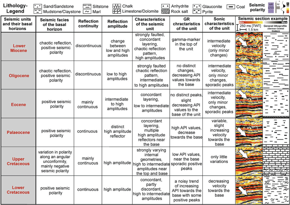
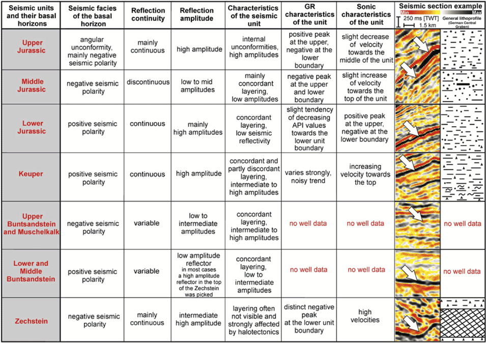
The boundaries of 13 major stratigraphic units, including the Late Permian (Zechstein Group) to the Neogene (Lower Miocene) were interpreted (Table 2). In general, every 10th to 20th inline and crossline was interpreted in the 3D surveys, corresponding to a 100 m resolution. Minor inconsistencies between the interpretations of different surveys due to differences in acquisition and processing were analysed and minimised by applying individual vertical shifts and local smoothing. Horizons were gridded with a cell size of 100 m × 100 m using a faulted convergent gridding algorithm with high grid coverage and low smoothing applied. The red lines in Table 2 constitute the mapped seismic horizons presented in this paper. The seismic characteristics of these reflectors are summarised in Table 3. In addition, based on the lithological information from wells in the study area, Table 3 shows a generalised description of sediment types deposited within the German Central Graben area.
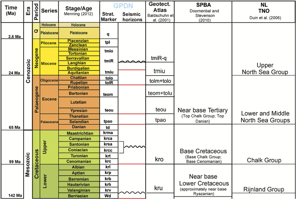
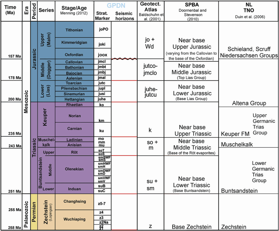
Simplified stratigraphic chart showing the age of the main mapped intervals (seismic horizons; red lines). Wavy lines indicate major unconformities in the German on- and offshore area. Square brackets indicate the varying times of the unconformity. The geological time scale after Menning (Reference Menning2012) was used. Comparisons were made to the Geotectonic Atlas of Northwestern Germany and the German North Sea (Baldschuhn et al., Reference Baldschuhn, Binot, Fleig and Kockel2001), Southern Permian Basin Atlas (Doornenbal & Stevenson, 2010) and the mapping study in the Netherlands North Sea sector after Duin et al. (Reference Duin, Doornenbal, Rijkers, Verbeek and Wong2006).
Seismic characteristics of interpreted horizons and associated units (base Lower Miocene to the base Lower Cretaceous). For each interpreted horizon characteristics refering to the seismic facies, reflection continuity, reflection amplitude, internal configuration of the associated seismic unit as well as distinctive features in the Gamma Ray and Sonic-Log are described. The seismic convention is illustrated in the upper right corner. The presented generalised lithoprofile is based on well data within the German Central Graben area.
Time–depth conversion
Time–depth conversion was performed using a linear velocity approach for several layers except for the Zechstein salt (Table 4). This approach of a linear velocity increase with depth was applied previously for regional mapping projects according to Baldschuhn et al. (Reference Baldschuhn, Binot, Fleig and Kockel2001), Van Dalfsen et al. (Reference Van Dalfsen, Doornenbal, Dortland and Gunnink2006) and Kombrink et al. (Reference Kombrink, Doornenbal, Duin, Den Dulk, Van Gessel, Ten Veen and Witmans2012).
Summarised seismic characteristics of interpreted horizons from the Upper Jurassic to the base Zechstein.
Layers used for time–depth conversion and their defined minimum and maximum velocity ranges. Ranges were defined based on sonic velocity logs.
Overview of major structural elements and main tectonic phases of their subordinate features. The last column summarises the burial history of the structural elements since the Late Jurassic.
The velocity at depth is calculated by the formula:
 $$V(z)\, = \,{V_0}\, + \,K\, \times \,z$$
where V 0 is the velocity at the surface, K is the gradient and z is the depth.
The result of the computation is one laterally constant K value for each layer and a V 0 value for each given location. The V 0 values were gridded for each layer to cover the study area. Considering the low number of wells in the study area no further statistical or geostatistical modelling was performed. Depth-converted horizons were inspected for misties at borehole locations. The depth error was generally less than 5% of the respective marker depth. In these areas the horizons were not corrected such that the depths at the well location were honored. Only above salt domes and at the flanks of salt domes were the misties greater. There and below the salt domes manual editing and correction was applied.
Structural interpretation
Within the Entenschnabel some 800 faults were interpreted. Faults were interpreted if a significant offset of more than 50 m of the horizons was visible over a distance of more than 1 km. The chosen average distances between the fault stick interpretations range from 100 m to 500 m. Partly, where the complexity along the fault plane increases or where the fault pattern is influenced by another fault or a salt structure, the interpretation was made in more detail with distances less than 100 m between the individual fault sticks. The structural style and geometry of fault structures differ significantly.
Salt structures were interpreted in time slices and vertical slices. For a more accurate model of the salt body, different seismic attribute cubes were calculated and interpreted (e.g. chaos, coherency, variance) in order to better constrain the boundary between salt and surrounding sediments.
Structural elements
Structural features in the central North Sea (the Netherlands, the United Kingdom, Norway, Denmark, Germany) including the Central Graben indicate that the present-day structural pattern of the subsurface of the North Sea results mainly from a Late Jurassic to Early Cretaceous rifting event (Wride, Reference Wride1995).
When comparing the structural features first documented within the Entenschnabel by Wride (Reference Wride1995) to our mapping results, it is evident that there is in general agreement on the existence of several structural elements but that exact localities, shapes and structural interpretations differ. The timing of the generation of some structural elements in particular has not been studied in detail. Principal structural elements can be defined on the bases of the depth map of the top pre-Zechstein (Fig. 2A). The structural names used in this work are partly adopted from Wride (Reference Wride1995). Most tectonic events since the Late Permian have left their imprint in the Palaeozoic bedrock of the Entenschnabel. The top pre-Zechstein shows over 200 fault traces with different fault offsets and strike directions (Fig. 2B). Generally, the fault pattern of the Mesozoic is distinctly different from that at the base Zechstein. Representative geological cross-sections in the time domain illustrate the structural geometry of major elements in Fig. 3. The northwestern study area is covered by section A trending WSW–ENE, while the central and southern realms are represented by profiles B (NE–SW, WNW–ESE, NW–SE), C (WNW–ESE, W–E, NNW–SSE, WSW–ENE, WNW–ESE) and D (W–E; Fig. 3).
Four regional geological cross-sections in the time domain (TWT) illustrating the main structural elements within the Entenschnabel (see Fig. 2B for locations).
The Entenschnabel comprises four major structural elements: the Schillgrund High, the German Central Graben, the Step Graben System and the Mid North Sea High (Fig. 4A). These major features are internally structured by a large number of minor features such as the John Graben and the Clemens Basin, which will be described in detail below (Fig. 4A).
A. Overview of major structural elements and sub-ordinate features, reflecting the structural pattern of the Entenschnabel area. 1, Outer Rough Basin; 2, Mads Graben; 3, Hans Graben; 4, John Graben; 5, Clemens Basin; 6, Mads High; 7, Hans High; 8, Outer Rough High; 9, Schillgrund High; 10, Mid-North Sea High. B. Map of salt structures in the study area.
The Dutch Step Graben (Kombrink et al., 2012) continues towards the north into the Entenschnabel area. In contrast to the Dutch offshore, this structural element corresponds in the German North Sea to a pronounced array of structural highs and grabens with associated large fault offsets in the pre-Zechstein and distinct thickness variations in the Mesozoic overburden. Because of the segmentation of this structural element into a number of equal extensional features in the Entenschnabel we prefer the term Step Graben System (Figs 2A and 4A).
Structural highs in the study area show different evolutionary stages and burial histories. Because of extensive erosion on most structural highs, often down to Zechstein strata or basement rocks, the basement and Zechstein are frequently overlain by Late Jurassic sediments (Fig. 3). Examples for structural highs are the Mads- and Schillgrund High (Fig. 3, Profiles B and C). In places, the Mads High and the Outer Rough High represent areas where thinned Zechstein strata are overlain by Cretaceous sediments (Fig. 3, Profile A). In the Dutch offshore sector such an area with mostly thin Mesozoic deposits is defined as a platform (Kombrink et al., Reference Kombrink, Doornenbal, Duin, Den Dulk, Van Gessel, Ten Veen and Witmans2012).
In particular, the basement in the German part of the Central Graben is segmented by a variety of horst and graben features. In some cases, graben structures in the basement are overlain by a basin in the Mesozoic overburden (e.g. John Basin on top of the John Graben). Besides the development of rift-dominated structures, an extensive diapirism affected the post-Zechstein overburden within the German Central Graben and the Step Graben System (Fig. 4B). In places, halokinesis ultimately resulted in the formation of salt diapirs, which also deformed overlying sediments and adjacent sediments through the formation of rim synclines (Schulz-Ela et al., Reference Schulz-Ela, Jackson and Vendeville1993). Consequently, Cretaceous and Cenozoic formations are characterised by radial fault patterns and crestal graben systems related to salt intrusion (Fig. 3, Profile C). The intensity of salt movement varies strongly between geological periods. Salt diapirs are mainly linked to interconnected NW–SE and NE–SW oriented faults in the Mesozoic overburden (e.g. Fig. 6).
A. Map showing the depth of the base Zechstein. B. The thickness of Zechstein. The mobilisation of Zechstein salt is visible by lateral thickness variations. The salt structures in the Entenschnabel with thicknesses of more than 1400 m are displayed as hatched areas.
Schillgrund High
The Schillgrund High represents the southeasternmost realm of the Entenschnabel and is bounded to the west by the Schillgrund Fault, which represents the main fault system of the Central Graben (Figs 2A and 4A). The Schillgrund High in the study area is partly overlain by thin (up to 200 m) Upper Jurassic sediments on top of Zechstein strata.
Missing Triassic and Early to Middle Jurassic sediments were probably deposited in the area because these sediments are preserved in surrounding grabens and basins, and point to major regional depositional trends across the Schillgrund High (Doornenbal & Stevenson, Reference Doornenbal and Stevenson2010). On the Schillgrund High these sediments were eroded due to an interplay of Late Jurassic structural evolution of the Central Graben, including its eastern graben shoulder and local thermal uplift related to the North Sea Dome (Fig. 3, Profile C). To the south the Schillgrund High continues as a platform area into the Dutch sector, where Cretaceous sediments overlie Triassic and Permian rocks (Kombrink et al., Reference Kombrink, Doornenbal, Duin, Den Dulk, Van Gessel, Ten Veen and Witmans2012).
German Central Graben area
The western border of the German Central Graben, oriented almost N–S, is defined by the transition into the Step Graben System and its associated sub-ordinate features (Figs 2A and 4A). To the east, the Central Graben is bounded by the Schillgrund Fault. The latter consists of listric NE–SW striking fault segments, partly inverted during the Late Cretaceous. These fault segments are linked by steep, in some parts faulted, relay ramps. A remarkable feature is the change in strike of the southeastern bounding faults of the German Central Graben area. They start in the south with an approximately N–S strike (Johannes Graben) and turn into a NW-SE strike half-way up the Entenschnabel (Fig. 2B). The dominant structural direction changes from NNE–SSW along the Schillgrund Fault to a NNW–SSE direction continuing into the Danish North Sea sector, as revealed by the pattern in the Top Pre-Zechstein horizon (Figs 2B and 4A).
The evolution of two NNW–SSE elongated Upper Jurassic basins, namely the John Basin and the Clemens Basin, has a major impact on the recent structural pattern in the Mesozoic strata of the German Central Graben.
John Graben and John Basin
The John Basin is related to a NNW–SSE oriented half-graben in the pre-Zechstein basement, the John Graben (Figs 2A and 4A). It is bounded to the west by the Johannes Graben and in the east has a transition into the Clemens Basin (Figs 2A and 4A). Similar to the German Central Graben area the John Graben existed as a structural feature in Palaeozoic times, but the main structural evolution has occurred since the Late Jurassic when differential subsidence clearly started. Within the John Graben, Late Permian (Zechstein) sediments are overlain by Mesozoic to Cenozoic deposits (Fig. 3, Profile C). The John Basin on top of the Zechstein is not significantly faulted. The basin structure in the Mesozoic overburden is wider than the graben in the Palaeozoic basement. Both structures are traceable towards the NNW into the Danish offshore sector.
Clemens Basin and Clemens Graben
The northern boundary of the Clemens Basin is marked by a transition into the Tail End Graben. In the south it terminates at the Schillgrund Fault. Its structure is strongly influenced by salt tectonics and the formation of rim-synclines. In most parts of the Clemens Basin the stratigraphic profile is truncated by erosion at the base of the Upper Jurassic (Fig. 3, Profile C).
Within the southernmost area of the Clemens Basin a strongly inverted graben, the Clemens Graben, is developed in the post-Zechstein strata (Fig. 3, Profile C). Lower Triassic sediments were probably deposited in the Clemens Graben, but these were subsequently eroded. The Clemens Graben experienced strong tectonic subsidence in the Late Jurassic, as indicated by Upper Jurassic sediments reaching a maximum thickness of up to 1800 m within the southern part of the Clemens Graben (Fig. 3, Profiles C and 11B). This represents the main evolution phase of the Clemens Graben. Nevertheless, inconsistencies in the internal geometry of the Triassic successions at the base of the present-day Clemens Graben point to a prior probably extensional and halotectonically influenced event during the Mid to Late Triassic. It can be assumed that the Late Jurassic structural feature of the Clemens Graben is related to that Mid to Late Triassic precursor.
Step Graben System
The northwestern boundary of the Step Graben System is defined by the Mid North Sea structural high and the eastern boundary represents the transition to the German Central Graben area (Fig. 4A). The Step Graben System is basically characterised by Late Permian (Zechstein) overlain by Upper Jurassic to Cretaceous sediments (Fig. 3, Profiles A and B). In places, Upper Jurassic deposits overlie Lower Buntsandstein. In the northwestern part of the Entenschnabel, structural elements with N–W to NNW–SSE orientation dominate the structural pattern. In most parts of the Step Graben System sediments are deeply eroded below the bases of the Upper Jurassic and Upper Cretaceous. The southern extension of the Step Graben System into the Dutch North Sea sector forms a terrace-like structure (Kombrink et al., Reference Kombrink, Doornenbal, Duin, Den Dulk, Van Gessel, Ten Veen and Witmans2012) between the Elbow Spit and Cleaverbank Platforms in the west, and the Dutch Central Graben in the east (Kombrink et al., Reference Kombrink, Doornenbal, Duin, Den Dulk, Van Gessel, Ten Veen and Witmans2012). Within the Dutch Step Graben the Jurassic is preserved locally. Lower Jurassic sediments were probably deposited in the area, but these were subsequently eroded by the Mid-Jurassic thermal uplift (Kombrink et al., Reference Kombrink, Doornenbal, Duin, Den Dulk, Van Gessel, Ten Veen and Witmans2012).
Mads Graben and Mads High
The NNW–SSE oriented Mads Graben formed as a half-graben during the Late Triassic. Its eastern boundary, the Mads Fault, is characterised by a southwest dipping, listric fault zone with a detachment deeper than 10 km (Figs 2B and 3, Profiles A and B). The hanging-wall of the Mads Fault is dominated by increased Triassic thicknesses (Figs 2A and 3, Profiles A and B). To the west, the Mads Graben is bounded by the Outer Rough High. During the Late Jurassic, the Mads Graben was affected by erosion cutting down in some places as deep as Lower Triassic strata. The Mads Fault was reactivated as a reverse fault during the Late Cretaceous and probably until the Palaeogene, as illustrated in Fig. 3 (Profile B).
The Mads High is sharply bounded to the west by the Mads Fault and represents a structural high, which is dominated by Upper Jurassic to Cretaceous sediments on top of Late Permian (Zechstein) strata (Figs 2A and 3, Profiles A and B). In the northwesternmost part of the Mads High, Upper Cretaceous sediments overlie thin relicts of the Zechstein or the Palaeozoic basement rocks. On the Mads High Triassic and Lower to Middle Jurassic sediments are missing (Fig. 3), which might indicate Jurassic to early Late Cretaceous uplift and erosional events.
Hans Graben and Hans High
The Hans Graben is a half-graben in the southeast of the Mads Graben. Based on the depth map of the top pre-Zechstein it is obvious that these grabens are separated by the northeasternmost part of the Step High (Fig. 2A). The Hans Graben is vertically and horizontally displaced to the Mads Graben and shows a complex internal fault pattern (Fig. 3, Profile B). However, the infill of the Hans Graben is similar to that of the Mads Graben (Fig. 3, Profile B).
The NNW–SSE oriented Hans High represents the southeastern extension of the Mads High structural element (Fig. 2A). The Hans High is sharply bounded to the west by the Hans Graben and to the south by the German Central Graben (Fig. 2A).
Outer Rough High
The Outer Rough High is sub-ordinate feature of the Step Graben System representing a widespread area where Upper Jurassic directly overlie Zechstein sediments (Fig. 3, Profile B). Lower to Middle Jurassic and Middle to Upper Triassic sediments are entirely eroded, probably due to Mid-Jurassic thermal uplift (Figs 7–10). To the east, this structural high grades into the Mads Graben (Fig. 2A).
A. Depth map of the base Lower Buntsandstein. B. Thickness map calculated between the base Lower Buntsandstein and the base Upper Buntsandstein. Hatched areas indicate locations of salt diapirs piercing the surface. Lower Buntsandstein sediments are mainly eroded on the Schillgrund High as well as in parts of the northwestern Entenschnabel (dark grey area).
A. Depth map of the base Upper Buntsandstein B. Sediment thicknesses of the Upper Buntsandstein and the Muschelkalk.
A. Depth map of the base Keuper. B. Thickness of the Keuper sediments.
A. Depth map of the base Lower Jurassic. B. Thickness map of the Lower Jurassic.
Outer Rough Basin
The Outer Rough Basin is an example of a structural element in the top of the Step Graben System. This basin is a structural element that does not entirely fit into the structural pattern of the Step Graben System, which developed from the Late Triassic to the Late Jurassic. The Outer Rough Basin represents the structural evolution from the beginning of the Cretaceous in this area and is characterised by the presence of thickened Lower Cretaceous to Lower Palaeogene sediments. There, the Upper Jurassic overlies thinned Zechstein deposits (Fig. 3, Profile A).
Mid-North Sea High
The Mid-North Sea High represents the northwesternmost realm of the Entenschnabel and has thin Upper Jurassic sediments overlain by Zechstein strata. The structural high is bounded to the east by the Outer Rough Basin (Fig. 4A).
Depth and thickness of the Upper Permian to Lower Miocene successions
Upper Permian (Zechstein Group)
The present-day depth of the base Zechstein in the Entenschnabel ranges from almost 2600 m on the southeastern Schillgrund High and on the Step High (Fig. 2A) to more than 7500 m in the John Graben (Fig. 5A). Basins that have subsided further during the Late Jurassic such as the German Central Graben area, including the John Graben and Clemens Basin, and later during the Cretaceous, such as the Outer Rough Basin, are clearly outlined on the depth map of the base Zechstein (Figs 2A and 5A).
A. Depth map of the base Middle Jurassic. B. Thickness of the Middle Jurassic.
The thickness of Zechstein strata varies considerably, indicating the mobilisation of Zechstein salt (Fig. 5B). Along the slopes of salt structures thicknesses significantly increase to about 1400 m and within the salt diapirs of the German Central Graben thicknesses up to 3000 m are reached.
Fault structures with large offsets dissecting the base Zechstein have a distinct influence on the thickness and distribution of the Zechstein Group (Figs 2B and 5B). This is partly shown by a decrease in thickness or absence of Zechstein sediments along the footwall of major fault structures and an increase in salt thickness on the hanging-wall near the faults (Figs 3 and 5B).
Triassic (Lower Buntsandstein, Upper Buntsandstein, Keuper)
The base Lower Buntsandstein attains depths of more than 7200 m within the John Graben (Fig. 3, Profile C and Fig. 6A). Triassic depth maps (Figs 6–8) reveal the outline of Keuper deposition in the German Central Graben area, which coincides largely with the Lower and Upper Buntsandstein sediment distribution. One exception is the Clemens Basin, where Keuper deposits are locally absent due to erosion (Fig. 8). In contrast to the Keuper and Upper Buntsandstein sediment distribution, the Lower Buntsandstein is in places preserved in the Step Graben System blocks A2–A9 and block B10 (Fig. 6A). The latter is characterised by almost complete absence of Upper Buntsandstein and a minor Keuper sediment distribution (Figs 7 and 8). In contrast, widespread Keuper sediments dominate the B8 block. On the Schillgrund High and parts of the Outer Rough High Triassic sediments are absent (Figs 6–8). As the result of Triassic subsidence, thick deposits have been preserved in the German Central Graben, in particular within the John Graben, surrounding areas of the Clemens Basin, at the hanging-wall of the Schillgrund Fault and in the Mads Graben (Figs 6B to 8B). The maximum thickness of the Triassic deposits reaches up to 3000 m (Figs 6–8). Except for local maxima in the German Central Graben thickness maps reveal a general decreasing thickness trend of Triassic sediments from the southeast towards the northwest within the Step Graben System (Figs 6B to 8B).
Jurassic (Lower Jurassic, Middle Jurassic)
The present-day depth of the base Lower Jurassic ranges from less than 2600 m to more than 5500 m in the John Graben (Fig 3, Profiles C and 9A). The Lower Jurassic is preserved in large parts of the German Central Graben and locally within the Step Graben System (Mads Graben). The Clemens Basin is marked by the absence of Lower to Middle Jurassic sediments. Middle Jurassic sediment distribution is dominated by widespread erosion in large parts of the study area, especially on structural highs (Fig. 10). Lower and Middle Jurassic depocentres are present in the John Basin and in a depression at the hanging-wall of the Schillgrund Fault with a total thickness of up to 1000 m (Figs 9B and 10B).
Upper Jurassic
The Upper Jurassic is preserved in large parts of the study area. The depth ranges between less than 2000 m and 5400 m inside the John Basin. In places, the Outer Rough High is characterised by the absence of Upper Jurassic sediments (Fig. 11A). Up to 2200 m of Upper Jurassic deposits are held within the John Basin (Fig. 11B). In the Step Graben System Upper Jurassic deposits attain thicknesses between 200 and 400 m. Some salt structures (e.g. Clara, Barbara, Claudia; Fig. 4B) show an increase in thickness in surrounding rim synclines during the Late Jurassic, indicating synchronous salt uplift.
A. Depth map of the base Upper Jurassic. B. Thickness of the Upper Jurassic.
Lower Cretaceous
The depth of the base Lower Cretaceous ranges between less than 1500 m on the roof of salt structures in the Central Graben and 3900 m within the NNE–SSW oriented Outer Rough Basin. The latter holds Lower Cretaceous sediments with a thickness of up to 1000 m (Fig. 12B). Only minor increases in the thickness are related to the Clemens Basin and the rim synclines of salt structures within the German Central Graben (Figs 12A and B). The widespread absence of Lower Cretaceous sediments along the northwestern border of the German Central Graben and in the Step Graben System due to presumed erosional events in the Late Cretaceous (Figs 12A and B) is remarkable.
A. Depth map of the base Lower Cretaceous. B. Thickness of the Lower Cretaceous.
Upper Cretaceous
The base of Upper Cretaceous ranges from less than 1500 m to more than 3600 m in the Outer Rough Basin and along the border to the Danish North Sea sector (Fig. 13A). The NNW–SSE oriented Outer Rough High is characterised by a distinct thickness minimum of Upper Cretaceous sediments. The Upper Cretaceous shows a significant change in depositional trend visible on the Schillgrund High (Fig. 13B) with thicknesses of more than 1200 m compared to older depocentres of Triassic to Jurassic sediments, which were located mainly within the German Central Graben (Figs 6B to 11B). In contrast, the Schillgrund high is characterised by absence of Triassic to Middle Jurassic and thinned Upper Jurassic to Lower Cretaceous sediments. In general, areas with low thicknesses, erosion or non-deposition from the Late Jurassic to Early Cretaceous are often characterised by increased thicknesses of Upper Cretaceous sediments.
A. Depth map of the base Upper Cretaceous. B. Thickness of the Upper Cretaceous.
Palaeogene: Lower Neogene (Base Palaeocene–Base Lower Miocene)
The Base of Palaeogene shows an increasing depth from 1800 m on the Schillgrund High to more than 2850 m within the Outer Rough Basin (Fig. 14A). At the top of some salt structures in the German Central Graben, the base Palaeocene attains depths of less than 1400 m (Fig. 14B). The Central Graben and further major Mesozoic structural features such as the John Basin, Clemens Graben or the Mads Graben are no more clearly visible in the depth of the Palaeogene (Fig. 14A). Thickness maps of the Palaeocene, the Eocene, the Oligocene and the Lower Miocene illustrate in detail the dynamic structural changes from the Palaeogene to the Lower Neogene (Figs 15A–D). The Palaeocene depositional trend shows similarity to the Upper Cretaceous, with maximum sediment thicknesses on the Schillgrund High and in the northwesternmost realm of the Entenschnabel. From the Eocene to the Lower Miocene depocentres changed several times. The outline of the Outer Rough Basin is visible for the last time in the thickness distribution map of the Eocene (Fig. 15B).
A. Depth map of the base Palaeogene. B. Thickness map calculated between the base Palaeocene and the base Lower Miocene.
Thickness maps of four sedimentary units (Palaeocene–Lower Miocene) in the Entenschnabel. A. The thickness of the Palaeocene shows no clear trend and is dominated by two depocentres, of which one is located alongside the Schillgrund High. The second depocentre is located in the northwest at the border to the Netherlands North Sea sector. B. Eocene deposits fill a depression (Outer Rough Basin) in the northwestern study area with up to 950 m of sediments. A trend of increasing sediment thickness from the southeast towards the northwest is evident. C. A change in the depocentre is illustrated within the Rupelian unit, which reaches a sediment thickness between 650 and 700 m at the border to the Danish North sea sector in the east. D. Map showing the thickness of the Lower Miocene unit with 250 m in the southeastern Entenschnabel on the Schillgrund High.
Discussion
Zechstein
Within the German Central Graben, the base Zechstein reaches a maximum depth of 7800 m (Fig. 5A). This is considerably deeper than in the Dutch North Sea, where the depth of the base Zechstein Group ranges from about 700 m in the southeastern part of the offshore Netherlands to more than 5000 in the Dutch Central Graben (Duin et al., Reference Duin, Doornenbal, Rijkers, Verbeek and Wong2006; Kombrink et al., Reference Kombrink, Doornenbal, Duin, Den Dulk, Van Gessel, Ten Veen and Witmans2012). However, in the southwestern part of the Entenschnabel the base Zechstein correlates well with the mapped depth of the base Zechstein Group in the Netherlands sector, as illustrated by Duin et al. (Reference Duin, Doornenbal, Rijkers, Verbeek and Wong2006) and Kombrink et al. (Reference Kombrink, Doornenbal, Duin, Den Dulk, Van Gessel, Ten Veen and Witmans2012). Salt tectonics had an important impact on sediment distribution and the subsequent deformation of Mesozoic and Cenozoic overburden, especially within the Central Graben. The north of the Schillgrund High is characterised by thin Zechstein deposits. In this area low initial thicknesses between 0 and 300 m of the Zechstein salt in combination with a change in the overall rock lithology (Doornenbal & Stevenson, Reference Doornenbal and Stevenson2010) prevented the formation of salt diapirs. Within the German Central Graben and the Step Graben System where the Zechstein thickness varies between 300 and 1400m thin-skinned tectonics is the dominant structural style (Fig. 3, Profiles C and D) in the Mesozoic overburden, as mentioned also by Ten Veen et al. (Reference Ten Veen, van Gessel and den Dulk2012) for the Dutch offshore. There, the salt forms a regional décollement, which decouples the deformation of the Mesozoic overburden from the deformation in the pre-Zechstein basement (Ten Veen et al., Reference Ten Veen, van Gessel and den Dulk2012; Duffy et al., Reference Duffy, Gawthorpe, Docherty and Brocklehurst2013; Maystrenko et al., Reference Maystrenko, Bayer and Scheck-Wenderoth2013). This can be clearly seen in the German Central Graben between the John Graben and the Clemens Basin (Fig. 3, Profiles C and D), where faults have not penetrated the sedimentary successions above the Zechstein. In the cross-sections it is apparent that the sub-Zechstein faults die out in the Zechstein salt while the supra-Zechstein faults floor-out in the Zechstein salt or at the base of the Lower Triassic (Fig. 3, Profiles A–D). If structures in the pre-Zechstein basement are coupled through the salt layers to the Mesozoic overburden, this is most probably controlled by the salt thickness, total fault offsets, displacement rates and the sediment load above the Zechstein (Ten Veen et al., Reference Ten Veen, van Gessel and den Dulk2012; Duffy et al., Reference Duffy, Gawthorpe, Docherty and Brocklehurst2013; Fig. 3, Profiles A–D). Ten Veen et al. (Reference Ten Veen, van Gessel and den Dulk2012) discussed the influence of these parameters on the decoupling of the deformation in the pre-Zechstein from that in the post-Zechstein.
Where the Zechstein salt does not fully decouple the deformation in the different structural levels, often a graben or a half-graben structure dominates the sedimentary evolution of the Mesozoic overburden, which is apparent in the area of the Mads Graben and the eastern German Central Graben (Fig. 3, Profiles A–C).
Triassic
Small variations of Triassic sediment thicknesses in the study area suggest that the German Central Graben area was only affected by minor tectonics during the Early Triassic. However, in the Late Triassic faults with large offsets developed in the German Central Graben and in the region of the Mads Graben (Fig. 3, Profile B), defining the present outline of the Triassic sediment distribution and significantly influencing the sediment thicknesses (Figs 6–8). Duin et al. (Reference Duin, Doornenbal, Rijkers, Verbeek and Wong2006) concluded that fault structures dissecting the Triassic sediments in the Netherlands North Sea sector are mainly a result of Late Jurassic rifting. This finding is confirmed for the Entenschnabel area.
Erosion of Triassic strata over structural highs (e.g. Mads High, Schillgrund High, Outer Rough High) mainly determines the stratigraphic profile of areas to the northwest and to the east of the German Central Graben (Figs 6–8). The Middle to Upper Jurassic uplift in the North Sea region Graversen (2006) is responsible for the erosion of Triassic deposits on structural highs.
The thicknesses of the Lower and Middle Buntsandstein sediments reveal an estimated accumulation rate of 166 m/Myrs for local areas in the hanging-wall of the Schillgrund Fault. In the same area, an accumulation rate of approximately 85 m/Myrs is estimated for Upper Buntsandstein to Muschelkalk time and 7.7 m/Myrs for Keuper deposits. The resolution in time varies strongly for the mapped seismic units in the Triassic. Without better constrains for the Mesozoic subsidence history of the German Central Graben and other parts of the Entenschnabel, the estimated average subsidence rates of the mapped seismic units are not sufficient for the interpretation of tectonic activity.
Initial rifting of the Central Graben
Our thickness maps indicate an initial evolution of the German Central Graben during the Triassic. Increasing thicknesses of the Lower Buntsandstein unit, which are directed towards a broad depression within the southeastern German Central Graben area, point to a first extensional pulse during the Early Triassic. There are almost no indications for faults that could have affected or controlled the formation of that depression (Fig. 6B). Thus, we suggest the Early Triassic to be the most plausible timing for the initiation of rift-related extension in the German Central Graben. This is in accordance with the assumptions for the timing of the initial rifting within the Dutch Central Graben by De Jager (Reference De Jager, Wong, Batjes and De Jager2007) and Frederiksen et al. (Reference Frederiksen, Nielsen and Balling2001) for the Central North Sea.
The initiation of the half-graben geometry of the German Central Graben started in the Mid-Triassic, which is documented by a NE–SW elongated depocentre along the Schillgrund Fault (Fig. 7B). A first major phase of rifting took place in the Late Triassic (Fig. 8B), which is evident from distinct increases in thicknesses of Keuper sediments at the hanging-wall of the Schillgrund Fault. Rifting activity decreases or terminated from the Late Triassic to the Mid-Jurassic. Thickness maps of this period (Late Triassic to the Mid-Jurassic) indicate minor local uplift and subsidence probably related to the mobilisation of the Zechstein salt but with no indication of active diapirism (Figs 8B to 10B).
During the Late Jurassic, the second major phase of rifting started and slowly decayed in the following Early Cretaceous (Figs 11 and 12), therefore we agree with Nielsen et al. (Reference Nielsen, Paulsen, Hansen, Gemmer, Clausen, Jacobsen, Balling, Huuse, Gallagher, Dore, Cartwright, Stoker, Turner and White2002) that further major phases of rifting in the Central Graben took place during Late Jurassic and Early Cretaceous.
The region of the German Central Graben area may have been influenced by earlier extensional tectonics as well, probably since Carboniferous time as postulated for the Dutch Central Graben by Van Adrichem Boogaert & Kouwe (1993). We can neither confirm nor exclude this statement for the Entenschnabel area, as mapping of stratigraphic units older than the Zechstein was not part of this study.
Jurassic
The base of the Upper Jurassic is marked by a significant regional angular unconformity. This explains the limited preservation of the sediments from the Lower Buntsandstein to the Upper Jurassic (Fig. 3, Profile D). Within the Danish Central Graben the top of the pre-Middle Jurassic succession is also defined by a major unconformity in the southern and central part of the Danish Central Graben (Andsbjerg, Reference Andsbjerg, Ineson and Surlyk2003).
The major erosion of Lower to Middle Jurassic sediments on the Outer Rough High, the Mads High and on the Schillgrund High correlates to the Middle to Late Jurassic up-doming and the partial inversion of the Central Graben area (Figs 9–11). Large parts of the Danish Central Graben also seem to be affected by large-scale regional uplift, as a result of the North Sea doming event during the earliest Middle Jurassic (Ziegler, Reference Ziegler1990; Underhill & Partington, Reference Underhill, Partington and Parker1993; Graversen, Reference Graversen, Doré, Cartwright, Stoker, Turner and White2002, 2006). Where Lower Jurassic sediments are preserved, low variability of the thickness suggests that the German Central Graben experienced only minor tectonic activity and halokinesis during the Early Jurassic. Within 22 Myrs up to 1300 m (60 m/Myrs) of sediments were deposited during the Early Jurassic within the John Basin (Fig. 9B). During the Late Jurassic a major extensional phase with subsequent reactivation of diapirism is evident by the growth of rim-synclines in the German Central Graben (Fig. 11B). Particularly in the John Basin above the John Graben and within the Clemens Graben up to 2800 m thick Jurassic sediments are preserved as a result of high subsidence driven by extensional tectonics in combination with salt tectonics. The thickness maps of the Middle and the Upper Triassic (Figs 7B and 8B) show a decrease in thickness where the Jurassic depocentre is situated. In contrast, the thickness of Triassic deposits increases towards the margins of the John Graben. This kind of depocentre shift over time and the absence of high offset faults in the Mesozoic cover indicates halotectonic movement of the Zechstein salt.
Cretaceous
Extensional tectonics initiated in the Late Jurassic ceased during the Early Cretaceous. Uplift and erosion during the Late Cretaceous strongly influenced the distribution of Lower Cretaceous and Upper Jurassic deposits. Duin et al. (Reference Duin, Doornenbal, Rijkers, Verbeek and Wong2006) concluded that Lower Jurassic sediments were partly eroded due to Late Cretaceous basin inversion and uplift in the Central Netherlands Basin, especially on higher fault blocks.
The present-day depth and preservation of Lower Cretaceous sediments was controlled by the Late Cretaceous structural evolution and by increased Cenozoic subsidence. With the exception of the Outer Rough Basin the Lower Cretaceous is absent in large parts of the Step Graben System. In contrast, the German Central Graben is characterised by continuous sedimentation from the Late Jurassic to the Early Cretaceous.
The structural evolution in the Late Cretaceous was characterised by thermal and partly tectonically driven (e.g. Schillgrund High) subsidence. The greatest thicknesses with up to 1600 m of Upper Cretaceous strata are reached on the eastern graben shoulder of the Central Graben, on the long-lived Triassic to Jurassic Schillgrund High (Fig. 13B). According to Nielsen et al. (Reference Nielsen, Balling, Jacobsen and Thybo2000) a global sea level rise during the Late Cretaceous led to deposition of sediments in the Central Graben and on the surrounding basement highs. Subordinate compressional tectonics in the Late Cretaceous resulted in local inversion of pre-existing Triassic to Jurassic structures (Wride, Reference Wride1995; Vejbæk & Andersen, Reference Vejbæk and Andersen2002; Gemmer et al., Reference Gemmer, Nielsen, Huuse and Lykke-Andersen2002a, Reference Gemmer, Nielsen and Bayer2003). This local inversion can be seen in the German Central Graben and in the Step Graben System. Inversion during the Santonian and post-Santonian time, as suggested by Kockel (Reference Kockel1995), affected especially the eastern part of the German Central Graben (e.g. Schillgrund Fault). Here large amounts of contraction are clearly visible along the Clemens Graben (Fig. 3, Profile C). Inversion tectonic led to a decrease in deposition of Upper Cretaceous sediments in the Step Graben System (Outer Rough High) and the German Central Graben (Fig. 13B). This major phase of contraction ended in the Campanian and from the Maastrichtian to the Palaeocene only minor compressional tectonics are documented in the study area, as postulated also by Kockel (Reference Kockel1995).
Palaeogene and Lower Neogene
Palaeogene deposits form continuous and sub-parallel horizontal layers reflect in general a ramp-type margin (Jacobs & De Batist, Reference Jacobs, De Batist, De Batist and Jacobs1996; De Lugt, Reference De Lugt2007). Minor unconformities and non-parallel layering indicate motion of some salt diapirs. During the Palaeogene, the tectonic regime changed from compressional to extensional (Ziegler, Reference Ziegler1990; Reference Ziegler1992). Because of this change of the tectonic setting, the depocentre shifted from the southeast on the Schillgrund High to the central North Sea (Figs 15A and D).
The Cenozoic North Sea Basin was affected by thermal subsidence enhanced by sediment loading (Ziegler, Reference Ziegler1990, Reference Ziegler1992). Vejbæk (Reference Vejbæk and Larsen1992) concluded that strong subsidence during the Cenozoic was mainly controlled by a combination of thermal relaxation and gabbro–eclogite phase transformation in the deep crust.
Locally in the northwestern study area (above the Outer Rough Basin) within 37 Myrs up to 1400 m thick Palaeogene sediments were deposited and preserved (Fig. 14B), resulting in an average sedimentation rate of approximately 36 m/Myrs. More than 2500 m of Cenozoic sediments are deposited within the German Central Graben. In the Danish part of the Central Graben the thickness of the Cenozoic sedimentary column varies between about 2000 m in the southern part to about 3000 m in the northern part, showing similar thickness values as in the Entenschnabel (Vejbæk & Andersen, Reference Vejbæk, Andersen and Ziegler1987; Vejbæk, Reference Vejbæk and Larsen1992).
Conclusion
Based on an extensive dataset of 3D and 2D seismic data and information from 27 wells we constructed detailed maps on the distribution, thickness and present-day depth of 13 key stratigraphic horizons within the Zechstein to Lower Miocene sedimentary succession in the Entenschnabel area. The geological evolution is reconstructed using major structural elements mainly defined in the pre-Zechstein basement (Table 5).
• Particularly within the German Central Graben, the structural style and fault patterns in Mesozoic strata are distinctly different from those below the Zechstein salt. Here, the Zechstein salt formations act as effective detachment horizons, which is obvious from the dominance of thin-skinned structures in the Mesozoic overburden.
• Thickness variations in the Lower Buntsandstein point to mild extension tectonics during the Early Triassic within the German Central Graben but without significant faulting activity.
The flow of Zechstein salt has not significantly influenced the Triassic sedimentary evolution. Small thickness variations suggest that the German Central Graben experienced minor tectonics during the Early and Middle Triassic. The absence of Triassic and Lower to Middle Jurassic sediments in the northwestern Entenschnabel and on structural highs is mostly due to local thermal uplift and concomitant erosion related to the Middle Jurassic North Sea dome and Late Jurassic tectonic events.
• During the Late Jurassic, a major extensional phase took place in combination with extensive reactive diapirism. Analyses of rim-synclines reveal that most of the salt structures had their main phase of growth during the Late Jurassic.
The Early Cretaceous saw the termination of the extensional deformation that initiated in the Late Jurassic. Early Cretaceous subsidence occurred in the German Central Graben and within the Outer Rough Basin.
• During the Late Cretaceous, most of the contraction and inversion was accommodated within the Central Graben, along the eastern border faults or in the Step Graben System (e.g. Schillgrund Fault, bounding faults of the Clemens Graben, Mads Fault). Inversion or reactivation mainly affected Triassic to Jurassic faults and sedimentary successions.
• The tectonic evolution during the Palaeogene was characterised by the change from compressional tectonics initiated in the Late Cretaceous to extensional tectonics from the beginning of the Eocene to the Miocene. Thermal subsidence of the North Sea Basin created accommodation space for the Cenozoic sediments within the study area. Closely related to the change in the tectonic regime was the initiation of a depositional trend with increasing thicknesses towards the North Sea Basin. Above the Outer Rough Basin Palaeogene and Lower Neogene deposits attain a cumulative thickness of up to 1400 m.
Acknowledgments
We thank the German North Sea Consortium (GNSC; BEB Erdgas Erdöl, Wintershall Holding AG, RWE DEA AG, EWE AG), Fugro Multiclient Services AS (FMCS) and TGS-NOPEC for permission to use their seismic data. We also thank the associated editor Geert-Jan Vis, and Johan ten Veen, Erik Rasmussen and an anonymous reviewer for their helpful and detailed comments, which helped to improve this article.