


Although Classic Maya salt kitchens have been identified at the Paynes Creek Salt Works, residences for the salt workers were elusive (Figure 1; McKillop Reference McKillop2019; McKillop and Sills Reference McKillop and Sills2016). Surplus household production can occur at home, in different buildings or in outdoor spaces, or separated from communities near the source of resource extraction for chert, salt, slate, and other materials (Healy et al. Reference Healy, Awe, Iannone and Bill1995; Hearth Reference Hearth and Robin2012; Horowitz Reference Horowitz2017; Shafer and Hester Reference Shafer and Hester1983; Sheets et al. Reference Sheets, Dixon, Lentz, Egan, Halmbacher, Slotten, Herrera and Lamb2015; VandenBosch et al. Reference VandenBosch, LeCount, Yaeger, LeCount and Yaeger2010; Whittaker et al. Reference Whittaker, Kamp, Ford, Guerra, Brands, Guerra, McClean, Woods, Badillo, Thornton and Eiley2009). The preservation of wooden posts that define the outlines of pole and thatch buildings in mangrove peat below the sea floor at the Paynes Creek Salt Works provides an opportunity to examine activities associated with different buildings at one of the largest sites, Ek Way Nal. It has ten wooden structures, so some of the buildings were expected to have been salt kitchens, whereas others were anticipated to be used for other activities, including as residences.
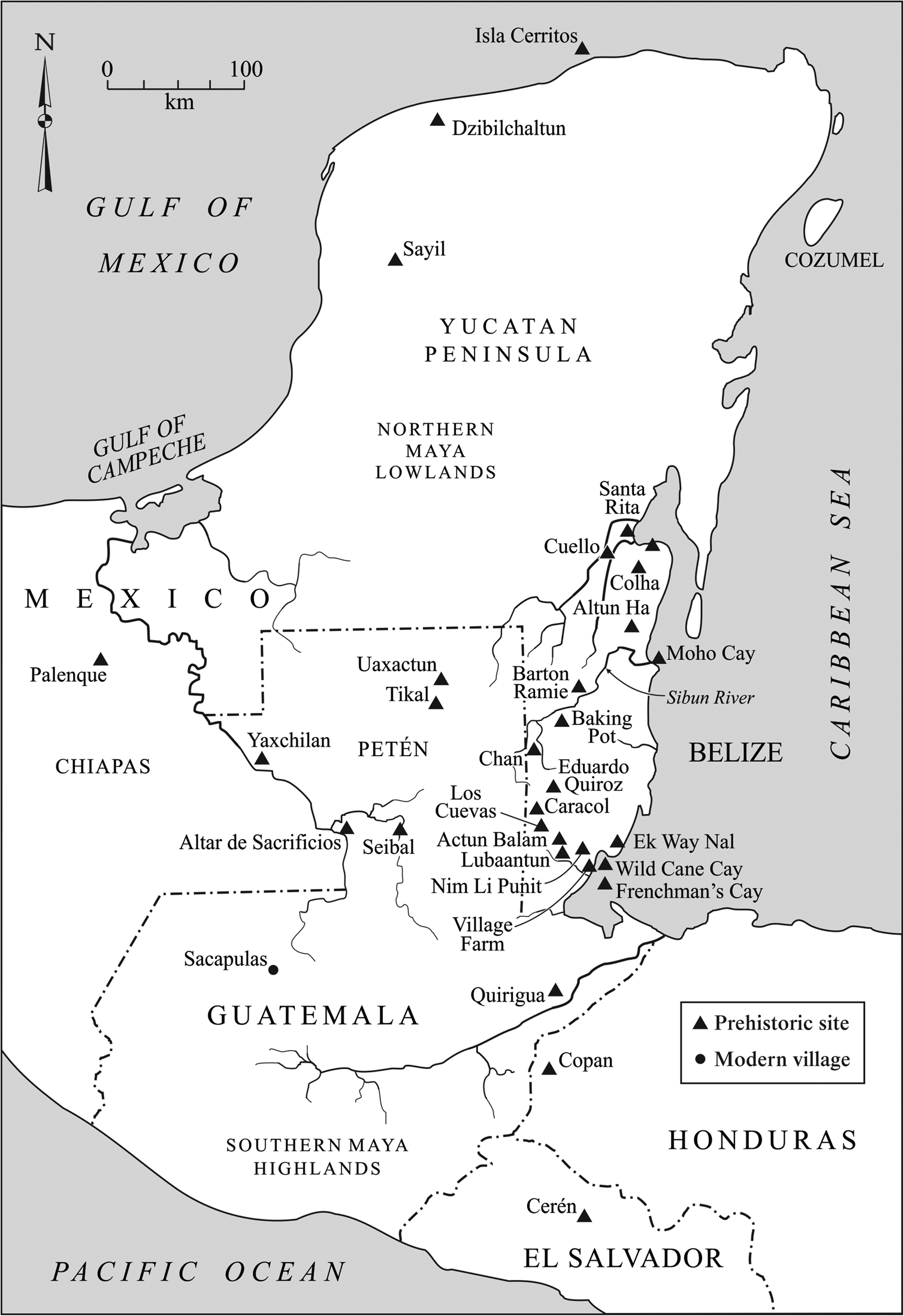
Map of the Maya area showing sites mentioned in the text. Map by Mary Lee Eggart.
The buildings’ uses provide information on the organization of salt production in the Late to Terminal Classic Maya economy (a.d. 600–900). Following Costin (Reference Costin and Schiffer1991), the organization of salt production at Ek Way Nal is evaluated in terms of factors of intensity (part-time/full-time), context (independent/attached), concentration (dispersed to nucleated), constitution (kin-based to industrial), and scale (size). Hirth (Reference Hirth and Hirth2009) provides useful categories of craft production, including intermittent single craft production, intermittent crafting, continuous single craft production, and continuous multi-crafting. Intermittent crafting is carried out in the household along with subsistence activities and is usually of short duration or periodic. Multi-crafting can include contingent crafting that represents production of goods used in the larger crafting process. Although not all of these factors can be evaluated from the surface mapped artifacts and buildings at Ek Way Nal, they provide a foundation for evaluating salt production at the site (see also McKillop Reference McKillop2019, Reference McKillop2021; Sills and McKillop Reference Sills and McKillop2018).
The salt-making community of Sacapulas in the Maya highlands is used as a model for evaluating the salt economy in relation to the patterns of artifacts associated with different buildings at Ek Way Nal (Reina and Monaghan Reference Reina and Monaghan1981). At Sacapulas, salty soil is produced by pouring water from a salt spring on nearby soil, letting it dry, and repeating the process over several days. The salty soil is then placed in an elevated wooden box nearby. A filter made from vegetation is placed over a hole in the base of the wooden box, with a large jar below. Salty water is poured over the soil and collected in the jar below the wooden box. This process is repeated until a ball of cornmeal floats, indicating the water is considered sufficiently salty. The enriched brine is then carried in jars to the salt kitchens, which are in a line near the salt spring, with the residences farther back. Each family has a salt kitchen and a residence and they work as a unit in salt production. The salt kitchens are used exclusively for making salt, including boiling brine on a fire hearth in the center of the building, storing brine and loose salt in jars along the walls, and storing salt cakes and broken salt pots. In addition, firewood is stored along a wall. Salty soil is piled on the floor for enriching it during the rainy season if more salt is needed. The broken salt pots are periodically moved to a pile outside. The brine-boiling bowls are made at the residences. The salt makers work full-time during the dry season, including transporting salt cakes to marketplaces in the region.
The same process of salt production is carried out using salt springs elsewhere in the Maya highlands, including San Mateo Ixtatán and Ixapa (Andrews Reference Andrews1983), but Sacapulas has the most detailed record, likely since salt was still being produced when Reina and Monaghan (Reference Reina and Monaghan1981) carried out their field research. Brine-boiling is a common method worldwide, currently and in the past, with summaries for Mesoamerica (Andrews Reference Andrews1983; McKillop Reference McKillop2019, Reference McKillop2021; Williams Reference Williams2021) and elsewhere throughout the world (Brigand and Weller Reference Brigand and Weller2015; Li and von Falkenhausen Reference Li and von Falkenhausen2010). Variations on brine-boiling, including the use of large pans to evaporate brine that has been concentrated in salinity in raised wooden devices, are described in studies elsewhere in Mesoamerica (Castellon Reference Castellon2016; Liot Reference Liot2000; Williams Reference Williams2021). Brine-boiling in central Mexico used fresh or salty water to enrich the salinity in soil from lake beds along lakeshores, resulting in different flavors and colors of salt (Parsons Reference Parsons2001). Ethnoarchaeological studies in the Philippines describe transporting salt cakes in clay pots for trade after the brine is boiled (Yankowski Reference Yankowski2019).
If the Sacapulas model fits Ek Way Nal, buildings were dedicated to salt-making, residences, and other purposes. Expectations for a household assemblage, a salt kitchen assemblage, and a fish-salting assemblage of artifacts include different suites of artifacts for various activities. Maya residences elsewhere typically include a diversity of pottery shapes for cooking, storage, eating, and serving, as well as other items. There may have been separate sleeping and kitchen buildings, as at Cerén (Sheets et al. Reference Sheets, Dixon, Lentz, Egan, Halmbacher, Slotten, Herrera and Lamb2015). Stone tools include manos and metates for grinding corn, as well as chert and obsidian objects. Also expected in residences are ritual items such as figurines and censers, plant and animal foods, and burials under floors, such as at the nearby island community of Wild Cane Cay (McKillop Reference McKillop2005a), rural Copan (Gonlin Reference Gonlin, Gonlin and Lohse2007), Chan (Robin Reference Robin2012), or Barton Ramie (Willey et al. Reference Willey, Bullard, Glass and Gifford1965). In contrast, a salt production assemblage features a lack of diversity of ceramics and a focus on salt-making, as at the Yotot site, where 98 percent of the pottery from excavations was briquetage, the broken pots and vessel supports from the brine-boiling process (McKillop Reference McKillop1995:Figure 10, Reference McKillop2002; McKillop and Sills Reference McKillop and Sills2016). Discarded briquetage would be expected if the salt was hardened into cakes for transport (McKillop Reference McKillop2021). A fish-salting assemblage included tools for cleaning and cutting fish, a rack for drying or a container for salt-drying fish, and fish bones, either indoors or in an outdoor space (McKillop Reference McKillop2019:118–121). Some fish bone elements may be missing if salt-dried fish were transported inland from the coast, as at the Northern River Lagoon site in northern Belize, where there was an underrepresentation of catfish vertebrae in comparison with catfish heads (Masson Reference Masson and Emery2004:114). Cut marks on fish bones may indicate flaying for sun drying at Colson Point on the central Belize coast (Graham Reference Graham1994). Soil chemistry, particularly calcium, may reveal evidence of fish (De Lucia Reference De Lucia2013; Knudson and Frink Reference Knudson and Frink2010), as suggested for the Chan b'i site in the Eastern Lagoon at the Paynes Creek Salt Works (Sills et al. Reference Sills, McKillop and Wells2016). Finally, mounds of leached soil and a large container for holding salty soil during brine enrichment would be expected in open areas, such as the plazas or yards. Earthen mounds of leached soil were excavated at Witz Naab' and Killer Bee in the mudflats elsewhere at the Paynes Creek Salt Works (Watson and McKillop Reference Watson and McKillop2019). Piles of discarded soil were likely once present at Ek Way Nal, but were eroded from wave action as the sites were submerged by sea-level rise. A wooden canoe with a hole in the base and funnel below from the Eleanor Betty site was likely used to hold salty soil during brine enrichment (McKillop et al. Reference McKillop, Cory Sills and Cellucci2014). Williams (Reference Williams2021) reports several earthen mounds at contemporary salt works in west Mexico, likely similar to the earthen mounds at the Placencia Lagoon Salt Works (Sills Reference Sills2016) and Northern River Lagoon (Masson and Mock Reference Masson, Mock, Demarest, Rice and Rice2004) that lack wooden buildings. In fact, Ek Way Nal may provide a model for these and other brine-boiling sites along the coast of Belize where wood has not preserved, including Marco Gonzalez (Graham and Pendergast Reference Graham and Pendergast1989), Wits Cah Ak'al (Murata Reference Murata2011), and Moho Cay (McKillop Reference McKillop and Garber2004), as well as others (McKillop Reference McKillop2019).
This article discusses the sea floor survey at Ek Way Nal, mapping of individual artifacts and wooden posts, and activities indicated by spatial patterns of the artifacts and buildings (Figures 1 and 2). The large size of the pottery sherds on the sea floor and embedded in it suggests that post-depositional site trampling was minimal, a view supported by the high percentage of vessel rim diameters of Punta Ycacos Unslipped at 7–20 percent and Warrie Red rims at 15–100 percent (McKillop Reference McKillop2002:108, Figures 3.48–3.50). The artifacts and posts are in firm red mangrove peat. The timing of deposition of the peat, its composition and timing in relation to the deposition of artifacts, and post-depositional site transformation processes are being evaluated in separate studies of the marine sediment (Foster Reference Foster2021; McKillop and Sills Reference Mckillop and Sills2021) and are beyond the scope of the current study. The patterns of artifacts associated with buildings dated to different times are evaluated from household and salt kitchen assemblages elsewhere to interpret ancient activities at the community and in particular buildings.
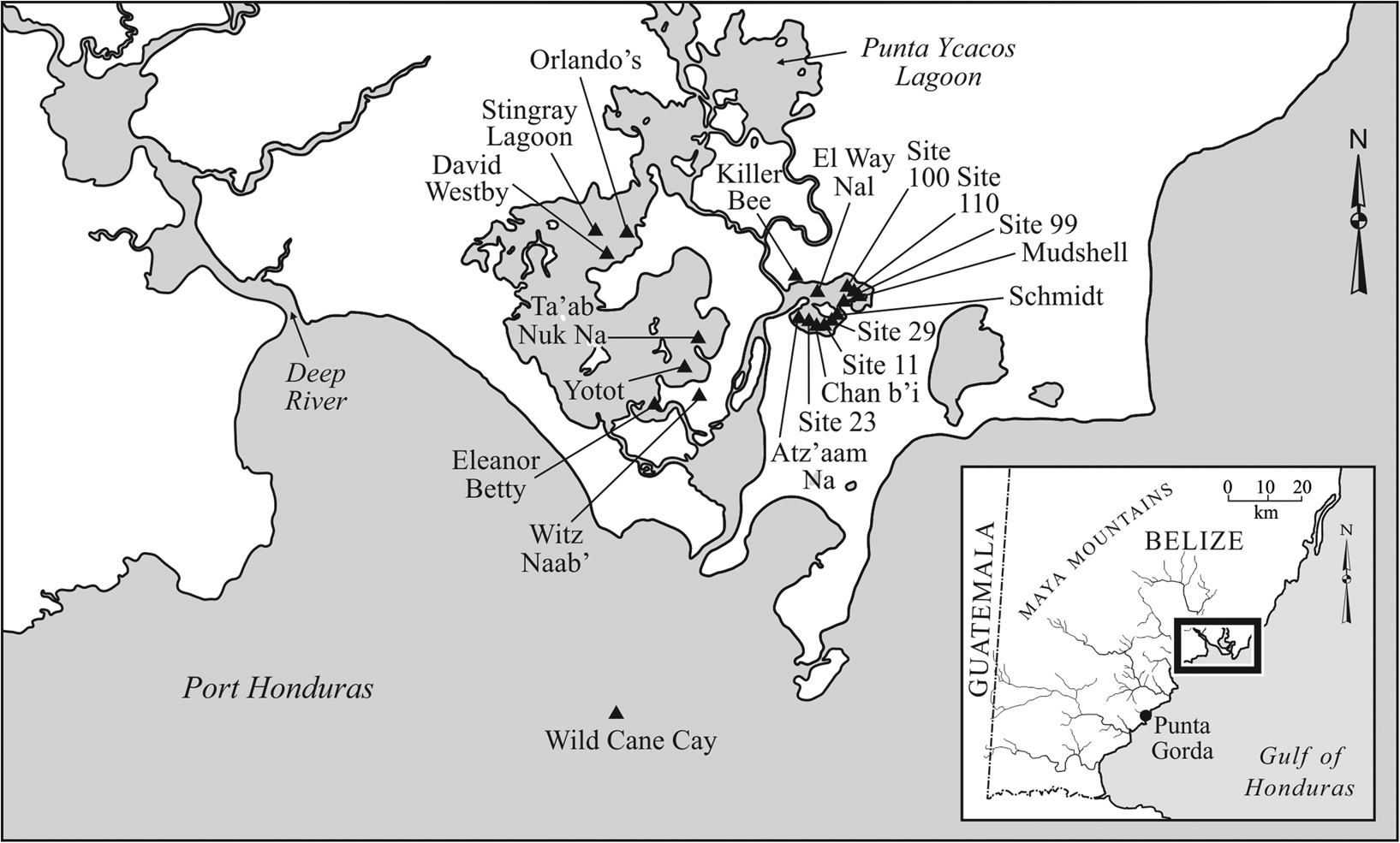
Map of Punta Ycacos Lagoon, showing sites mentioned in the text. Map by Mary Lee Eggart.
PAYNES CREEK SALT WORKS
Ek Way Nal is one of the largest underwater sites that comprise the Paynes Creek Salt Works, a complex of submerged sites in Punta Ycacos Lagoon that was focused on salt production using the method of boiling brine in pots over fires (Figure 2; Feathers and McKillop Reference Feathers and McKillop2018; Feathers et al. Reference Feathers, McKillop, Sills and Watson2017; McKillop Reference McKillop1995, Reference McKillop2002, Reference McKillop2005b, Reference McKillop2019; McKillop and Sills Reference McKillop and Sills2016, Reference McKillop2017, Reference McKillop2019; Robinson and McKillop Reference Robinson and McKillop2013, Reference Robinson and McKillop2014; Sills and McKillop Reference Sills and McKillop2018; Sills et al. Reference Sills, McKillop and Wells2016; Somers Reference Somers2007; Watson and McKillop Reference Watson and McKillop2019; Watson et al. Reference Watson, McKillop and Cory Sills2013). The sites were submerged by sea-level rise that is documented by radiocarbon-dated red mangrove peat from a sediment column (McKillop et al. Reference McKillop, Cory Sills and Harrison2010). When the salt works were in operation during the Classic period (a.d. 300–900), they were on dry land along the shoreline of the lagoon. Each underwater site is defined by a cluster of artifacts and wooden posts visible on the sea floor and at least 10 m distant from another site. A total of 4,042 wooden posts define wooden buildings at 70 sites (McKillop Reference McKillop2019). Wooden posts are known from 30 additional sites, but they are too remote or in water too deep for total station mapping.
Excavations have been carried out at 19 sites (Figure 2), including Stingray Lagoon, David Westby, Killer Bee, Orlando's (McKillop Reference McKillop1995, Reference McKillop2002), Chan b'i (Sills and McKillop Reference Sills and McKillop2013, Reference Sills and McKillop2018; Sills et al. Reference Sills, McKillop and Wells2016), Yotot (McKillop and Sills Reference McKillop and Sills2016), Witz Naab' and Killer Bee (Watson and McKillop Reference Watson and McKillop2019; Watson et al. Reference Watson, McKillop and Cory Sills2013), Eleanor Betty (Feathers and McKillop Reference Feathers and McKillop2018; Feathers et al. Reference Feathers, McKillop, Sills and Watson2017), sites 11, 23, 29, and Atz'aam Na (McKillop Reference McKillop2019, Reference McKillop2021; Sills and McKillop Reference Sills and McKillop2018), five underwater shell midden sites (Schmidt, Mudshell, sites 99, 100, and 110; McKillop Reference McKillop2017), and Ta'ab Nuk Na (Foster et al. Reference Foster, McKillop and Sills2019; McKillop Reference McKillop2018; McKillop and Sills Reference Sills and McKillop2019; Sills and McKillop Reference Sills and McKillop2019). Ek Way Nal has not been excavated but as one of the largest sites, with ten buildings and associated artifacts embedded in the sea floor, the site provides an opportunity to evaluate activities in the different buildings.
Salt was produced at the Paynes Creek Salt Works by enriching salty water by pouring it over salty soil and then boiling the brine to make salt. This method of salt production is common worldwide in antiquity, historic times, and currently, as practiced in the Maya highlands at Sacapulas and other communities with salt springs (Andrews Reference Andrews1983; Reina and Monaghan Reference Reina and Monaghan1981). The method results in briquetage, as well as earthen mounds of leached soil from the brine-enrichment process. Excavations at the Paynes Creek Salt Works provide examples of these processes. At the Yotot site, for example, transect excavations yielded briquetage inside and immediately outside the pole and thatch salt kitchens, with few artifacts in the fenced open yard (McKillop and Sills Reference McKillop and Sills2016). Excavation of one of the earthen mounds at Witz Naab' revealed it was leached soil from brine enrichment (Watson and McKillop Reference Watson and McKillop2019; Watson et al. Reference Watson, McKillop and Cory Sills2013). Earthen mounds were probably associated with each salt kitchen, as shown ethnographically, but were eroded at the Paynes Creek Salt Work sites due to wave action and hurricanes after the sites were submerged underwater. Witz Naab' and Killer Bee are the only remaining earthen mounds known to be associated with the salt works, although there are unexcavated earthen mounds nearby on the savannah and on offshore islands. The Eleanor Betty site has a wooden canoe that had been repurposed as a container for holding soil in the brine enrichment process (McKillop et al. Reference McKillop, Cory Sills and Cellucci2014). The canoe had a line of palmetto palm posts on either side, wooden pegs holding it up, and a large clay funnel underneath to collect enriched brine in a pot below.
EK WAY NAL SITE DESCRIPTION AND SEA FLOOR SURVEY
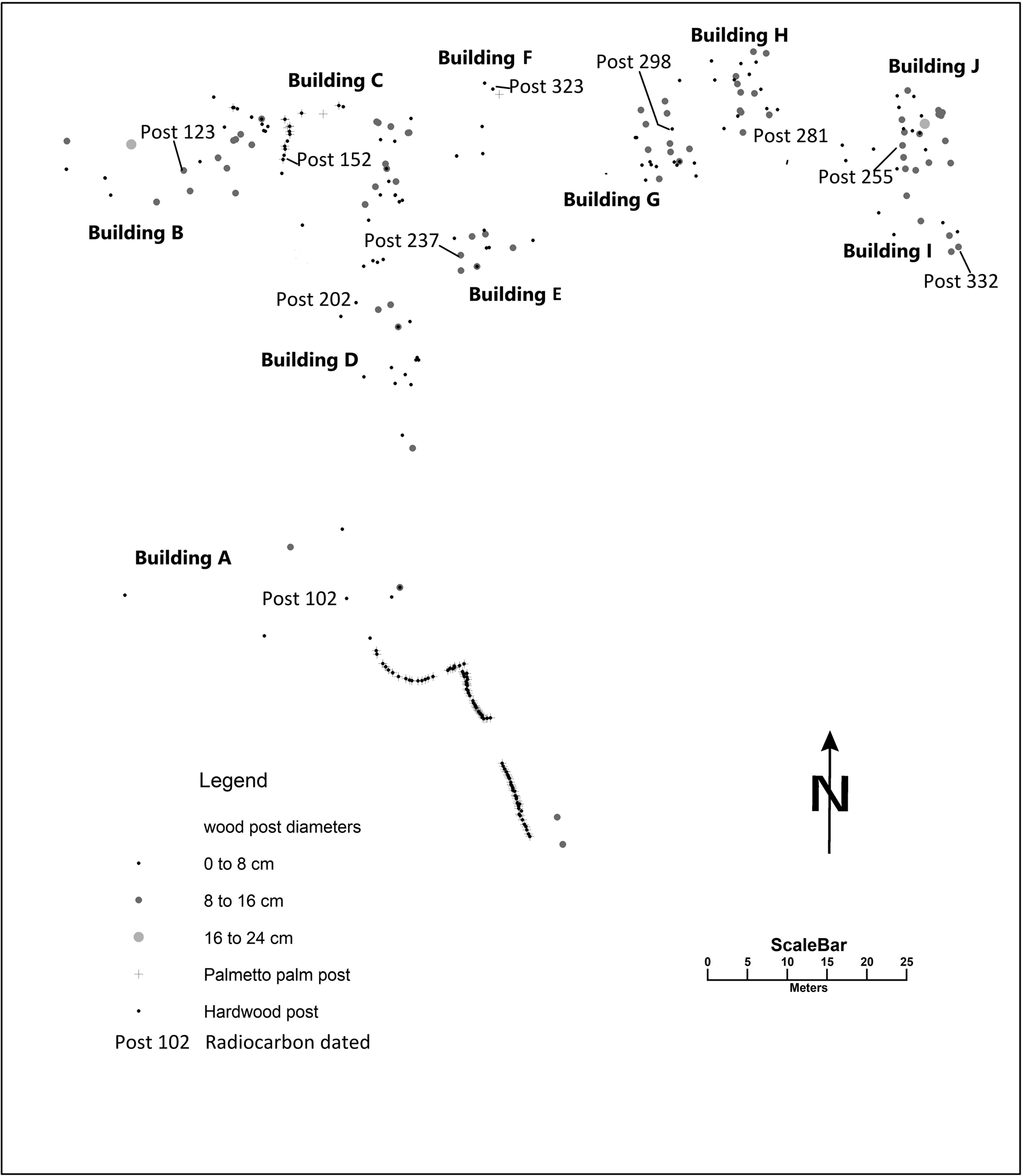
Ek Way Nal has 201 hardwood posts that form the walls of ten buildings, as well as 109 palmetto palm posts (Acoelorrhaphe wrightii). Most of the palmetto palm posts form a line at the southern edge of Ek Way Nal, defined by the lack of artifacts beyond that point. Lines of palmetto palm posts are located at the edges of many of the sites at the Paynes Creek Salt Works. Artifacts are lacking beyond the posts, suggesting their use either to shore up the land and/or as a fence around buildings and a yard or plaza. Palmetto palms are water-resistant and are commonly used today in Belize to protect shorelines. Plotting the hardwood posts by their diameter sizes shows larger corner posts as well as building shapes. The buildings were pole-and-thatch structures similar to houses and other buildings in traditional Maya villages (McKillop Reference McKillop2019:Figure 4.2; Wauchope Reference Wauchope1938). Post diameters averaged 6 cm for palmetto palm posts, but ranged from 7 to 18 cm for hardwood posts. The size ranges for posts are based on Wauchope's (Reference Wauchope1938) divisions in pole-and-thatch building construction. Corner posts and exterior walls were larger, at 6–12 cm in diameter.
Special techniques were devised to locate and map Ek Way Nal due to its shallow, underwater location, mostly less than 1 m in depth (Figure 3). The survey team traversed the site back and forth, shoulder to shoulder, on research flotation devices, pivoting to site a PVC pole marking the previous traverse (Figure 4). Floating above the site allowed the team to see the sea floor without walking on it and damaging it, or stirring up the silt on the sea floor, which reduces visibility underwater. Wooden posts and artifacts in the sea floor at Ek Way Nal were flagged for mapping. The posts barely protruded from the sea floor. The site extended from a mangrove spit of land into shallow water in the East Lagoon on the north. The larger part of the site was south of the spit of land, where the greater water depth precluded survey without dive gear. The southern boundary of the site was not determined.
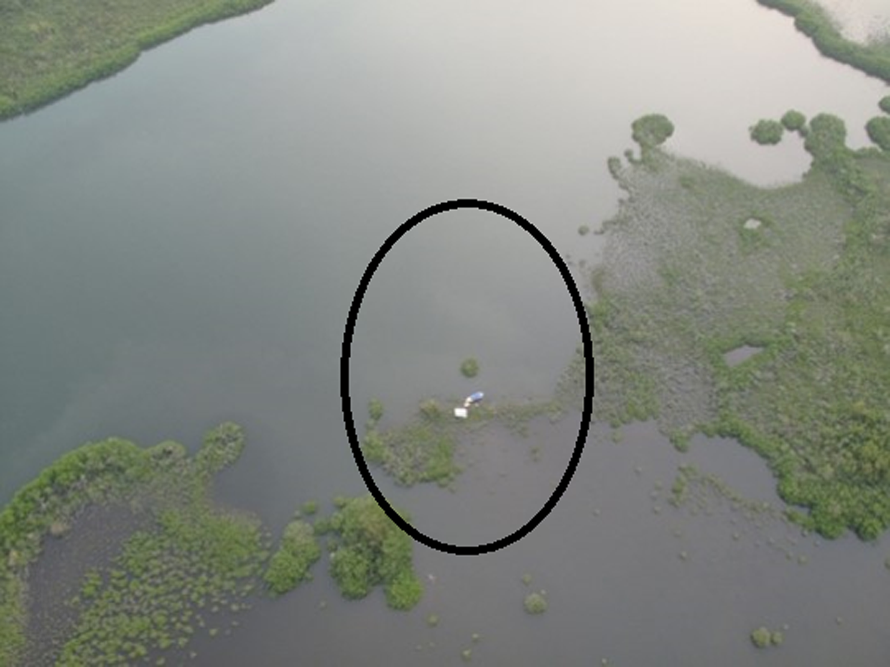
Drone aerial view of Ek Way Nal, in Punta Ycacos Lagoon, with the site area circled. Photograph by Eddie Weeks, Louisiana State University, from the Underwater Maya project.
Flotation survey at Ek Way Nal, with flags marking locations of wooden posts below the sea floor. Photograph by McKillop.
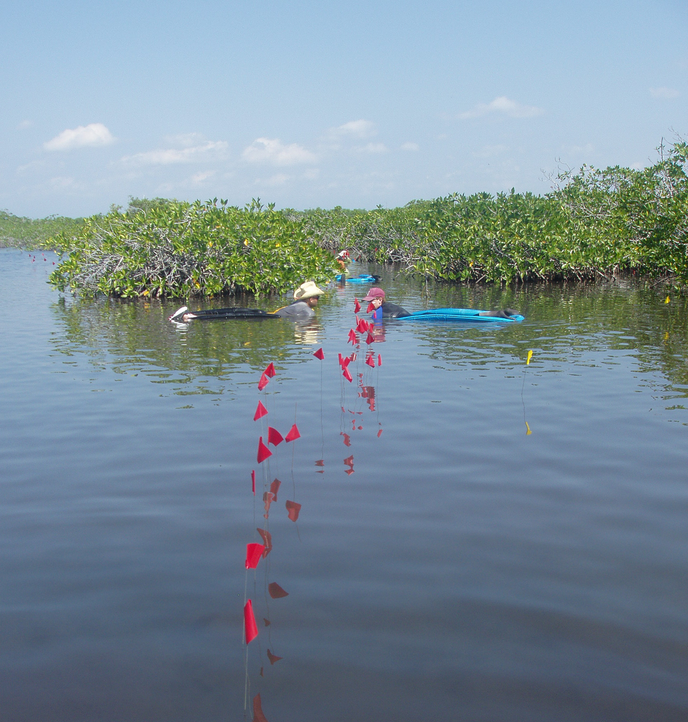
Temporally diagnostic and distinctive pottery, all chert and obsidian, and other materials such as wood and ground stone, were marked with yellow survey flags, along with posts marked by red flags. They were labeled using capital letters for artifacts and numbers for posts. Among the sea of colored and labeled flags, spatial patterns of buildings and artifacts were not apparent. Each flagged post and artifact was mapped from a total station at a permanent cement datum with a PVC pipe sunk into its center.
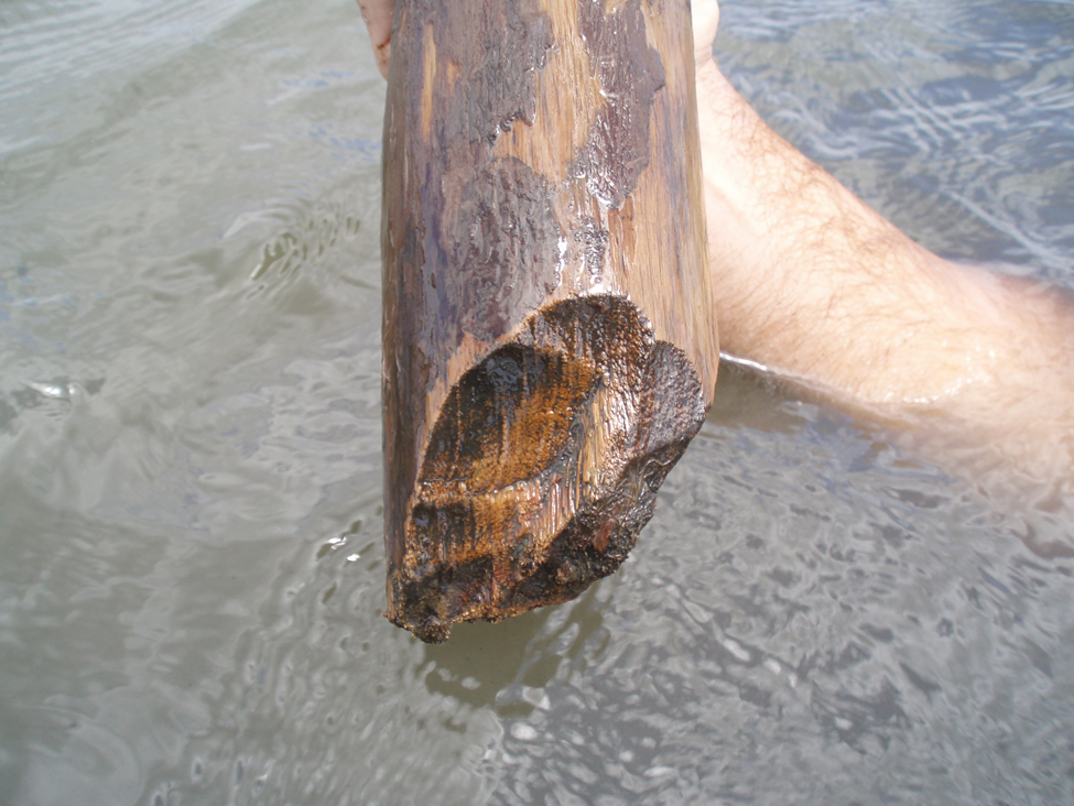
The diameter of each wooden post was measured underwater using a plastic tape measure. Wood samples were then cut using stainless steel knives, after clearing mangrove peat from around the rotted tops of posts at the sea floor. Each post sample was placed in a Ziploc bag full of water to preserve the integrity of the wood structure for species identification. Selected posts were excavated if they were short and became loose during wood sampling or to determine whether they were posts (Figures 5 and 6). Excavated posts with cut ends were 3D-scanned as a permanent record since the wood decayed over time in water.
Wooden post 305 from Ek Way Nal. Photograph by McKillop.
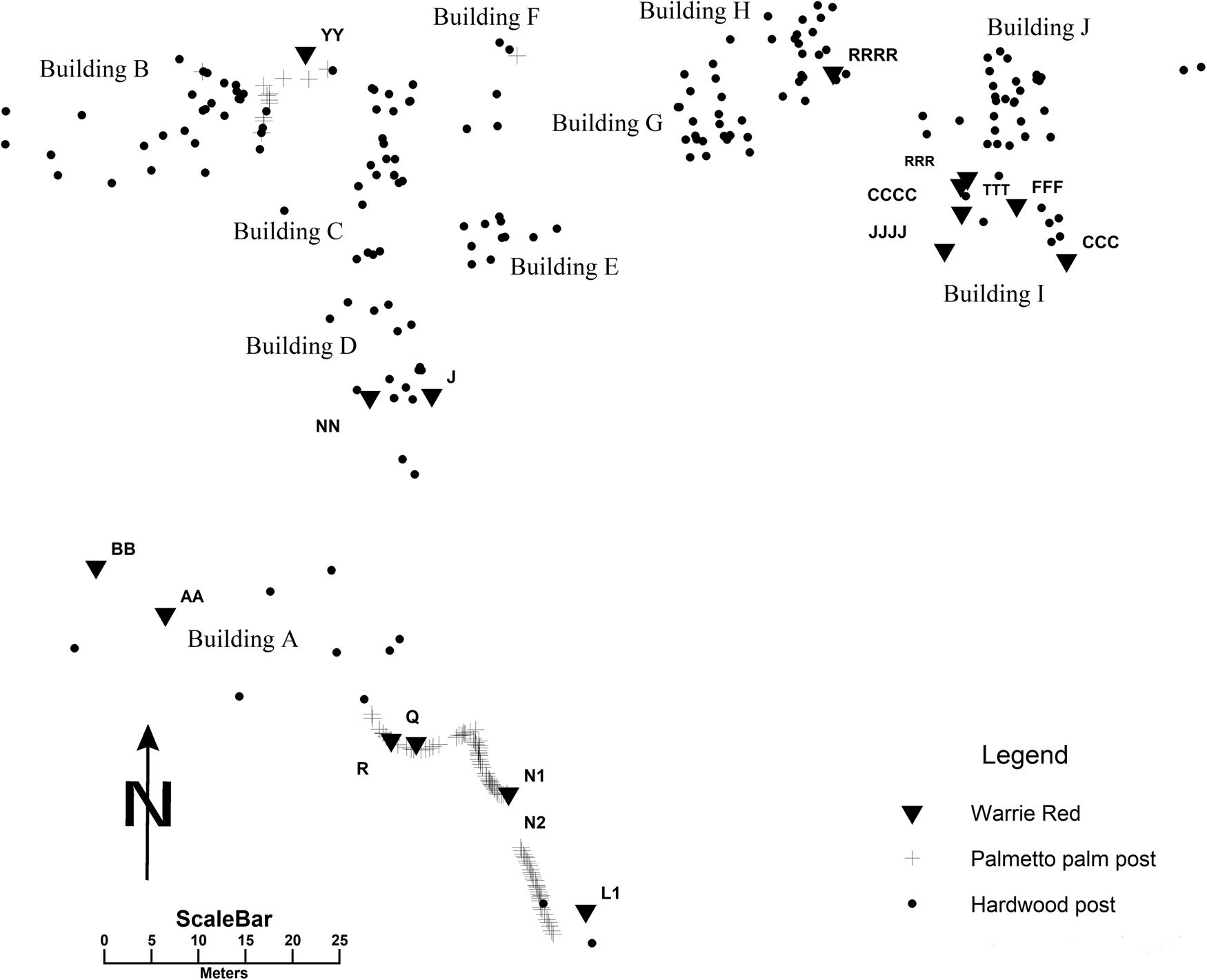
Map of wooden posts at Ek Way Nal by post diameter size, with buildings labeled and posts selected for radiocarbon dating named. Map by McKillop.
DATING THE WOODEN BUILDINGS
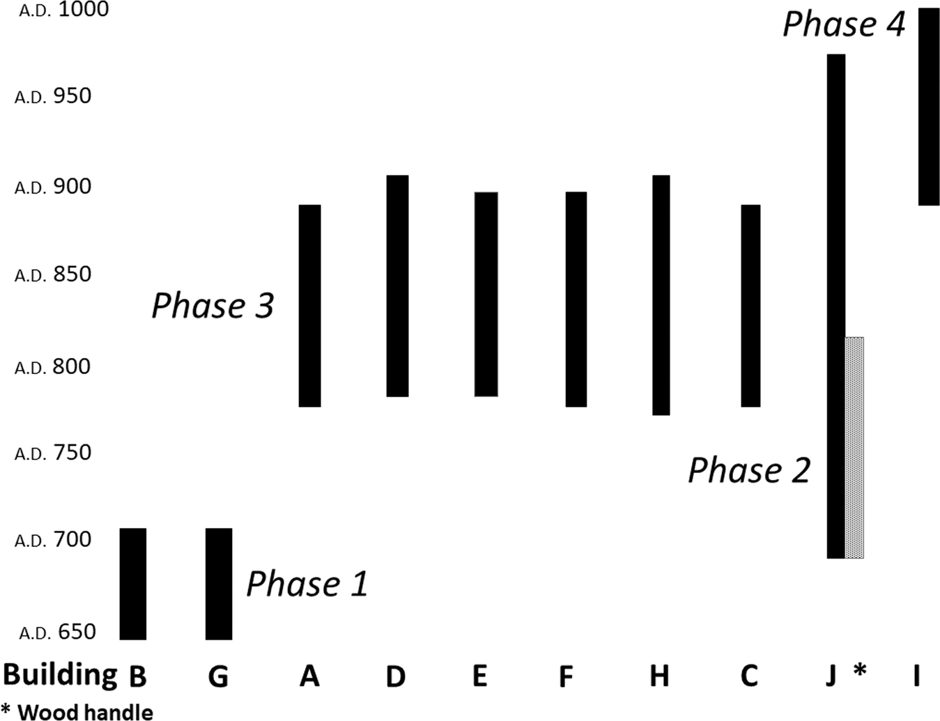
A wooden post from each of the ten buildings was radiocarbon dated (Table 1). The dates indicate that the buildings were constructed at four different times (Figure 7). First, Buildings B and G were constructed near the beginning of the Late Classic. Then Building J was constructed. The radiocarbon date of a.d. 660–810 on the rosewood handle of the jadeite gouge found beside post 255 in Building J provides a shorter time span than the date for the wooden post (Table 1 and Figure 7). Buildings A, C, D, E, F, and H were constructed sometime from the end of the Late Classic to the Terminal Classic. The radiocarbon date for Building I indicates it was constructed at some point from the Terminal Classic to the Early Postclassic. The use date for the building can be refined by the absence of Postclassic pottery indicating that Building I was used in the Terminal Classic. The outline of posts from Buildings I and J overlap, which means that the buildings were not contemporary.
Radiocarbon dates for wooden posts and rosewood handle from Building J. Drawing by McKillop.
Radiocarbon dates for wooden posts from Ek Way Nal.
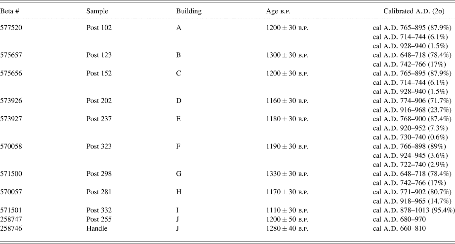
Note: Beta # 256256 and 258257 were previously reported in McKillop and Sills Reference McKillop and Sills2019.
Building construction dates provide the earliest use of the structures, which may have lasted 40–50 years or more, with replacement of roofing thatch (10–20 years, depending on the species of palms) and periodic replacement of some wood posts (Good Reference Good1995; Wauchope Reference Wauchope1938). The 50-year range for the first buildings, B and G, in the early part of the Late Classic, suggests their building life. The 100-year range of the third construction episode is probably too long.
Apart from the briquetage which is not distinctive to particular time periods, other pottery, in particular Belize Red and Warrie Red, indicate a Late to Terminal Classic age for the use of the buildings. Belize Red is a volcanic ash tempered ceramic that is easily identified by its soft paste. The type was first described for Barton Ramie and the Belize Valley (Gifford Reference Gifford1976). Belize Red was previously described as Moho Red for the Paynes Creek Salt Works for the first three excavated sites (McKillop Reference McKillop2002:86–90, Figures 3.35–3.37). Belize Red occurs from the Late Classic through the Terminal Classic at Caracol, both in burials and on building floors (Chase and Chase Reference Chase and Chase2012:8).
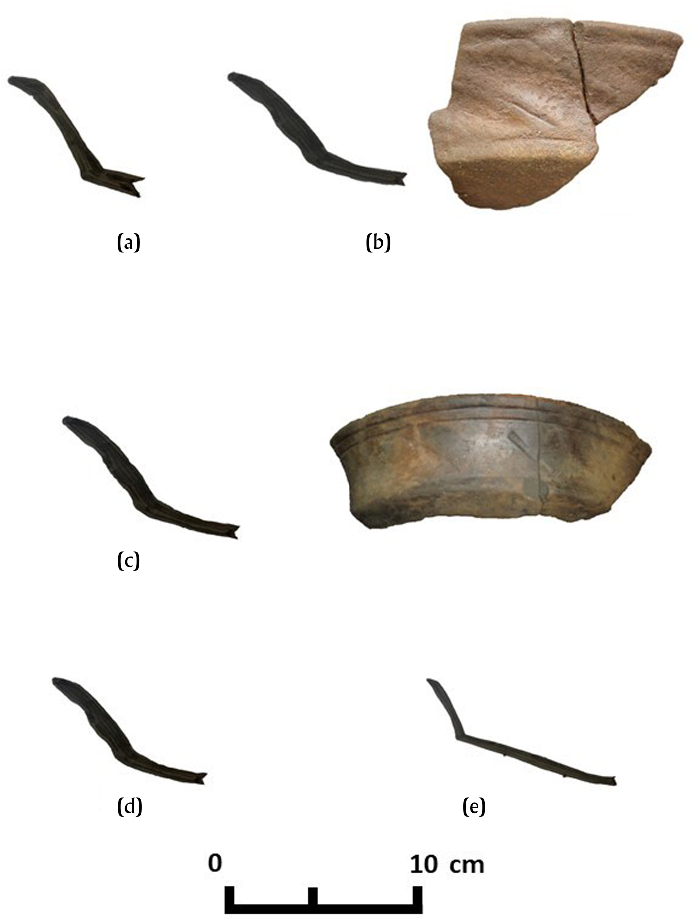
The small sample of decorative modes of Belize Red bowls recovered from the sea floor are not specific to particular Late to Terminal Classic buildings at Ek Way Nal (Figures 8 and 9, Table 2). Bowls with horizontal incised lines and diagonal incisions and/or gouges in a panel on the exterior of the vessel are present in the first construction phase in Building B (artifact WW), the third construction phase in Building A (Z), and the fourth construction episode in Building I (YYY). Notched basal angles are on Belize Red sherds from Building D (HH, QQ, and K) and from Building I (EEE). A plain basal angle is on a sherd with a flat base from Building J (HHH).
Belize Red bowl rim sherds, with catalog identifications. (a) WW; (b) Z; (c) YYY; (d) EEE; (e) HH. Photographs by McKillop.
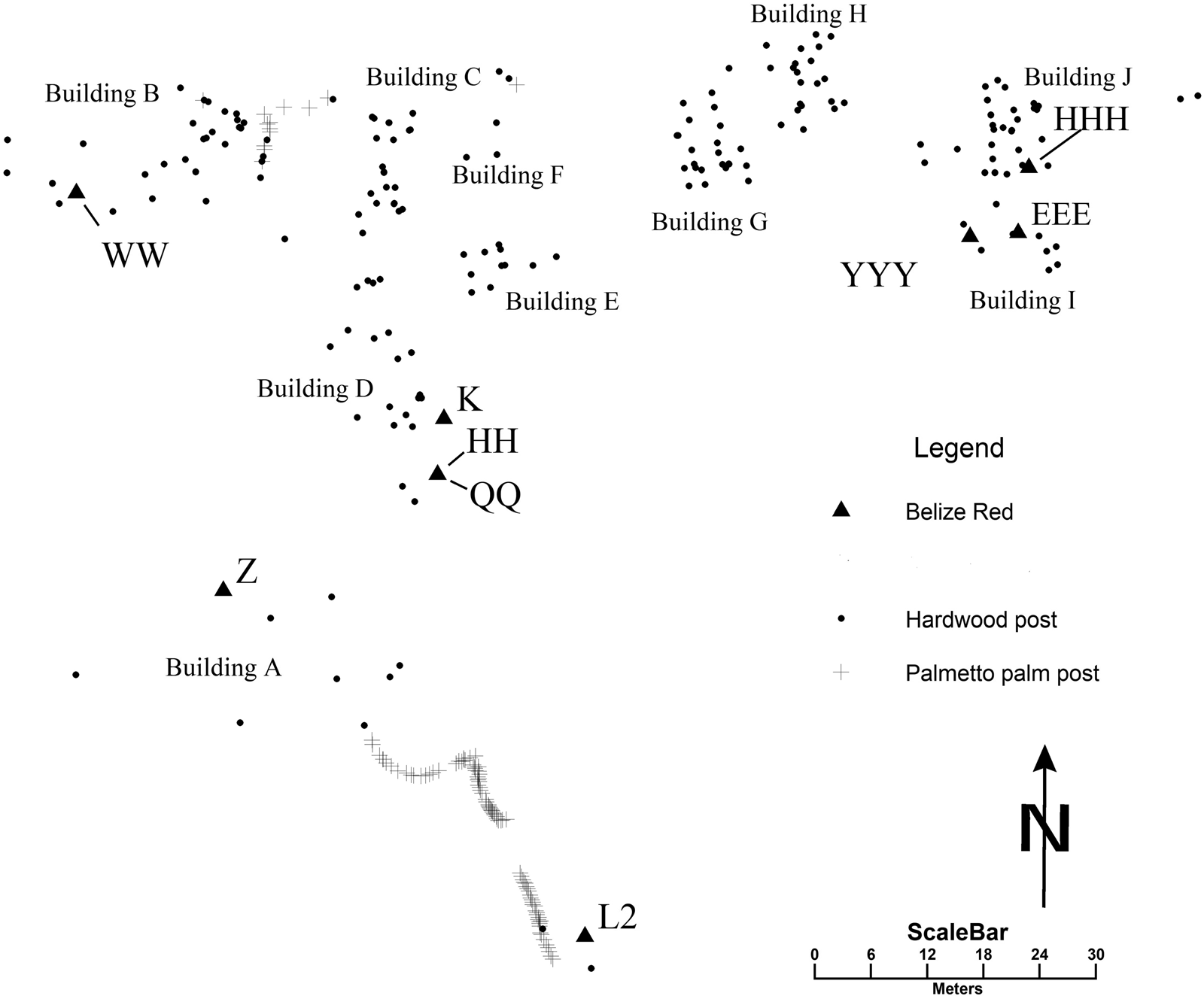
Map of Ek Way Nal posts showing locations of Belize Red pottery identified by catalog numbers. Map by McKillop.
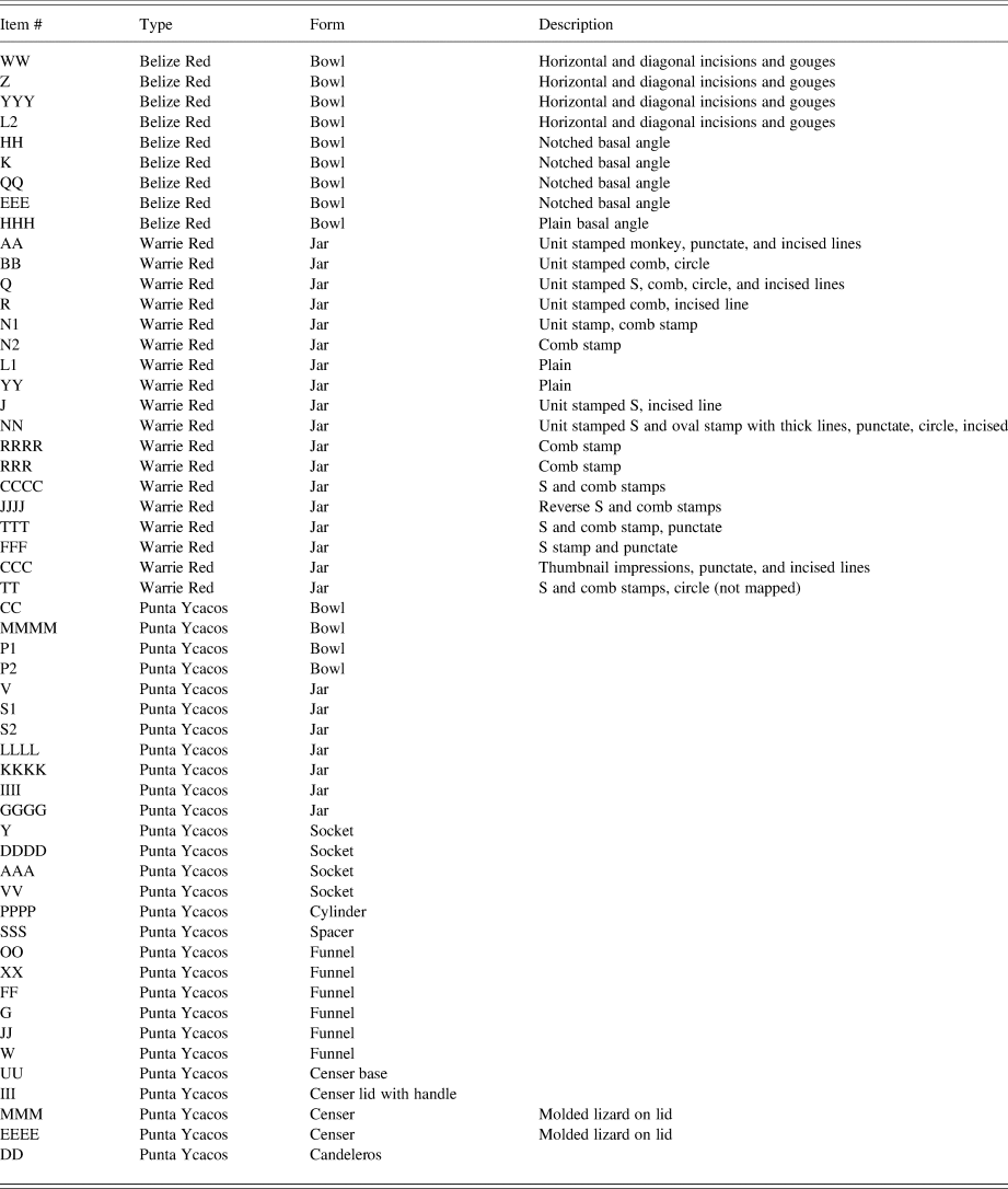
Description of pottery mapped on the sea floor at Ek Way Nal.
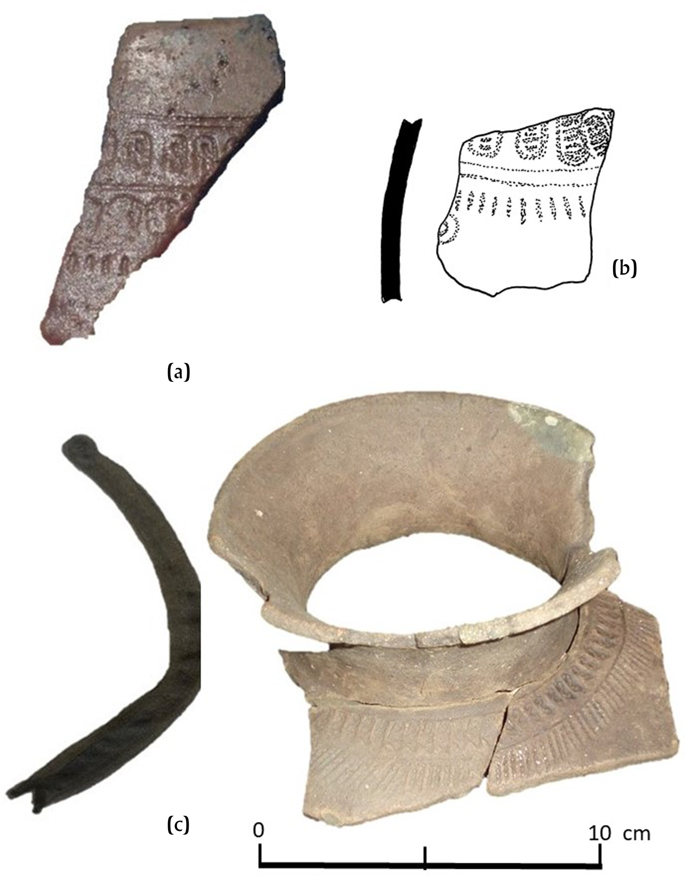
Warrie Red jars, including some with unit-stamped decorations on the vessel shoulder, were found in buildings A, C, D, H, and I, and near the palmetto palm posts. The unit-stamped pots corroborate the radiocarbon ages of the buildings at Ek Way Nal. The type resembles Remate Red from Lubaantun and Tinaja Red from Seibal and Altar de Sacrificios (Adams Reference Adams1971; Sabloff Reference Sabloff1975). Remate Red ceramics comprise over 42 percent of Late Classic and over 28 percent of Terminal Classic pottery at Nim Li Punit (Fauvelle Reference Fauvelle2012:Table 1). Warrie Red has more diversity in stamped decorations than Remate Red at the other southern Belize sites or sites in adjacent Guatemala. The type was described based on 81 sherds from Stingray Lagoon, David Westby, and Killer Bee sites (McKillop Reference McKillop2002:77–86, Figures 3.27–3.30). No unit-stamped decorations are associated with Buildings B or G that are dated to the Late Classic, suggesting that unit-stamping was used later. The unit stamps on pottery in buildings in the Late and Terminal Classic include monkey, S, reverse S, circles, comb stamps, and abstract motifs, as well as incised lines (Figures 10 and 11, Table 2). Building I has S, reverse S, punctate, and comb stamps, as well as thumbnail impressions, indicating the building was used in the Terminal Classic and not the Early Postclassic.
Warrie Red jar sherds, with catalog identifications. (a) AA; (b) NN; (c) JJJJ. Photos and drawing by McKillop.
Map of Ek Way Nal posts showing locations of Warrie Red pottery, identified by catalog numbers. Map by McKillop.
The practice of unit-stamping red slipped jars extends from the coast of southern Belize inland to Lubaantun, Nim Li Punit, and Pusilha, and west to Seibal and Altar de Sacrificios (Adams Reference Adams1971; Hammond Reference Hammond1975; McKillop Reference McKillop2002; Sabloff Reference Sabloff1975). Unit-stamped decoration occurs in the Late Classic at Lubaantun, which coincides with its use at Ek Way Nal. Unit-stamped decoration also occurs on bowls and jars in caves in the Maya Mountains, including Las Cuevas (Kosakowsky et al. Reference Kosakowsky, Moyes, Robinson and Voorhies2013), Rio Frio, Eduardo Quiroz, and Actun Balam (Pendergast Reference Pendergast1969, Reference Pendergast1970, Reference Pendergast1971, Reference Pendergast1974). The stamping found on jars at Ek Way Nal is more similar to the monkey and S motifs from Lubaantun than to the abstract motifs from Altar de Sacrificios, Seibal, and the Petexbatún. Elsewhere in the Paynes Creek Salt Works there are abstract motifs like the Petexbatún unit stamps, as well as the suite of motifs at Ek Way Nal (McKillop Reference McKillop2019).
ACTIVITIES ASSOCIATED WITH DIFFERENT BUILDINGS
The distribution of artifacts and posts suggests specific activities were associated with different buildings at Ek Way Nal and underscores the value of individually mapping the posts and artifacts. The results are qualitative since only diagnostic or other distinctive artifacts were flagged and mapped during sea floor survey, but the distribution provides clear indications of different activities. The diversity of artifacts is a stark difference to the Yotot site where briquetage dominates the sea floor and subsurface (McKillop and Sills Reference McKillop and Sills2016). Although salt production took place, other activities did as well. The Ek Way Nal Maya were engaged in a variety of activities in different indoor and outdoor spaces, some related to salt production, such as salting fish and wood working, as in Hirth's (Reference Hirth and Hirth2009) contingent multi-crafting. Other activities, such as music, consuming food, and ritual, are not directly related to making salt. Since ground corn was used in salt production, grinding corn may be considered a contingent activity.
Salt Production
Briquetage was mapped in Buildings A, B, C, E, G, and I, as well as associated with the line of palmetto palm posts (Figures 12 and 13). The briquetage includes jars, bowls, clay cylinder vessel supports, sockets at the end of cylinders where the pot rested, bases attached to cylinders, and spacers that may have been placed between jars to keep them separated on the fire (McKillop Reference McKillop2002:Figures 3.3–3.20). Buildings without salt production include Buildings D, F, H, and J as potential residences.
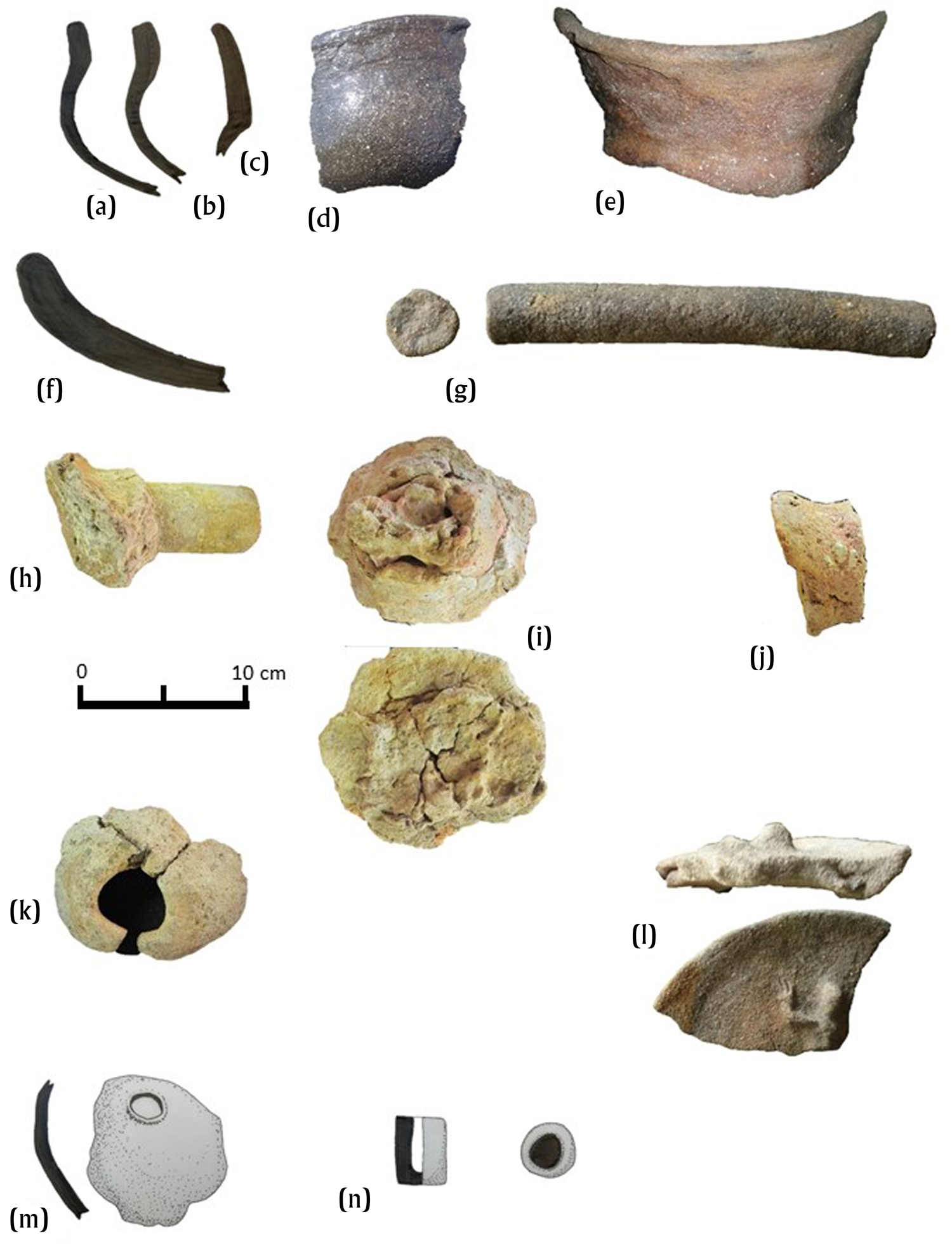
Punta Ycacos Unslipped pottery, with catalog identifications. (a) S1 jar profile; (b) S2 jar profile; (c) GGGG jar profile; (d) S2 exterior; (e) 60 GGGG exterior; (f) CC shallow bowl profile; (g) PPPP clay cylinder; (h) VV socket; (i) AAA socket and base; (j) SSS spacer; (k) W funnel; (l) MMM incense lid; (m) G1 funnel; (n) DD candelero. Photographs and drawings by McKillop.
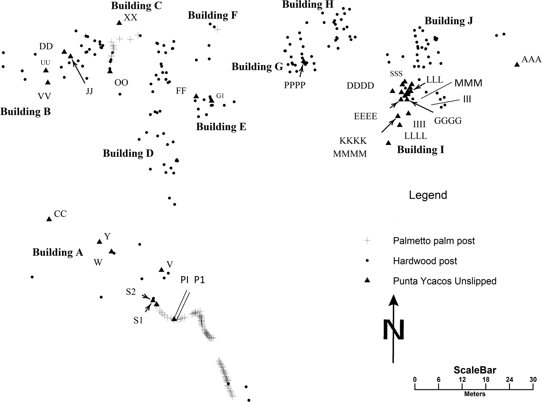
Map of Ek Way Nal posts showing locations of Punta Ycacos Unslipped pottery identified by catalog numbers. Map by McKillop.
Occupation of Ek Way Nal may have been seasonal, but the salt kitchens provided shelter from rain and made brine-boiling possible year round, as at Sacapulas, where salty soil is stored in the salt kitchens, banked against the walls and on the floor, which raised the level of the floor around the brine-boiling area. (Reina and Monaghan Reference Reina and Monaghan1981). Brine would be enriched by pouring salty water through salty soil, as at Sacapulas. Although the acidic peat did not preserve microfossils or marine shells that could inform about seasonality, the presence of fruits that ripen throughout the year supports year-round use of Ek Way Nal, with the possibility of salt production year round as well (McKillop Reference McKillop2019:122).
Salt-dried Fish
Activities in buildings A and C and the line of palmetto palm posts included processing fish, perhaps including salt-drying fish (Figures 14 and 15, Table 2). Use-wear analysis by Kazuo Aoyama indicated that artifacts X in Building A and ZZ in building C were used to cut fish and/or meat (McKillop and Aoyama Reference McKillop and Aoyama2018:Table 1). Artifact T beside the line of palmetto palm posts was used to scrape hide or scale fish. Fish or meat processing was concentrated in the west area of the community. Only one additional chert artifact from Ek Way Nal was studied for use-wear, so there may reasonably be more tools that were used to process fish or meat. Buildings A and C were among the six buildings dated to the Terminal Classic during the main use of Ek Way Nal, which evidently included salt-making and processing fish and/or meat (McKillop Reference McKillop2019).
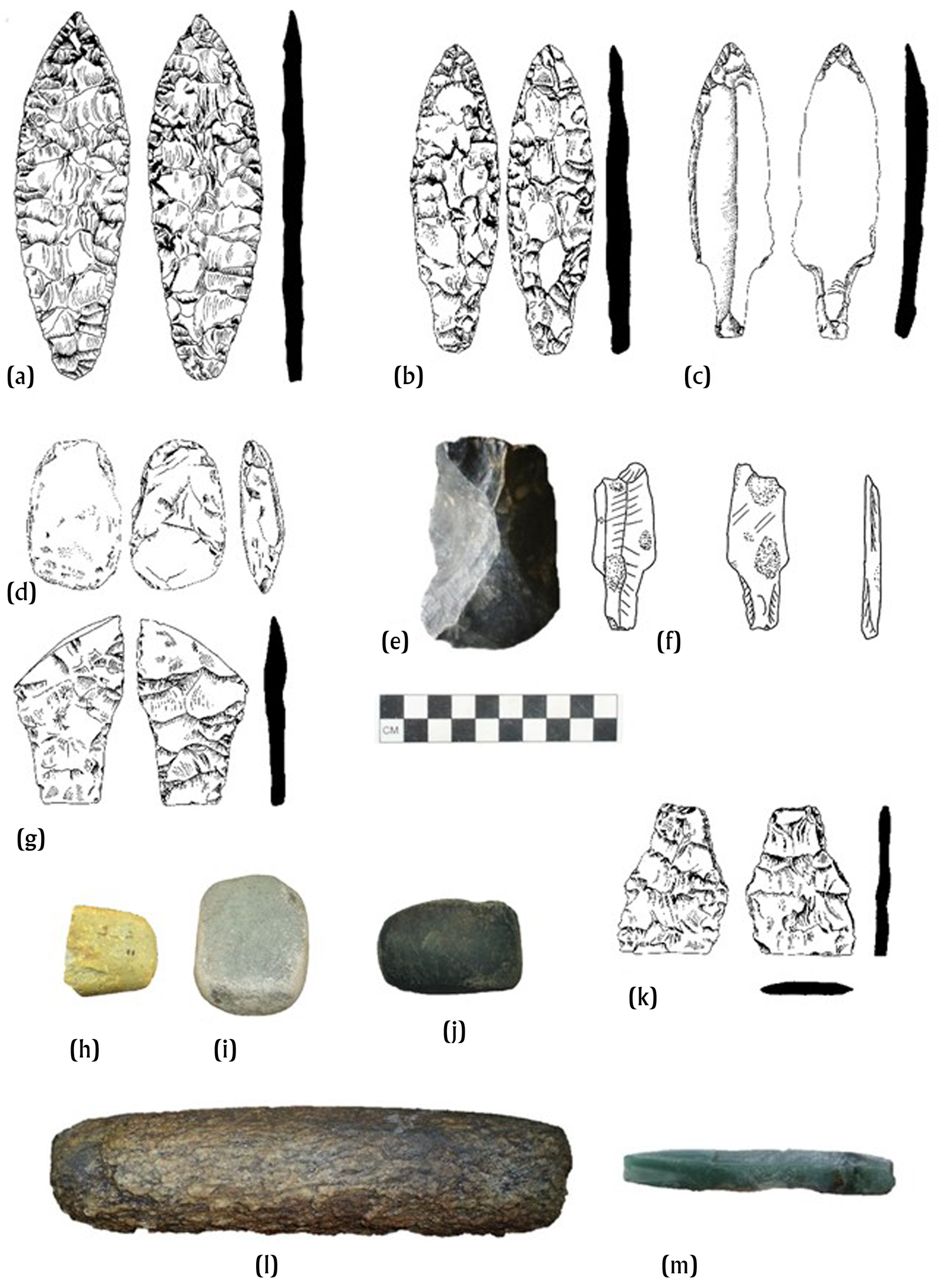
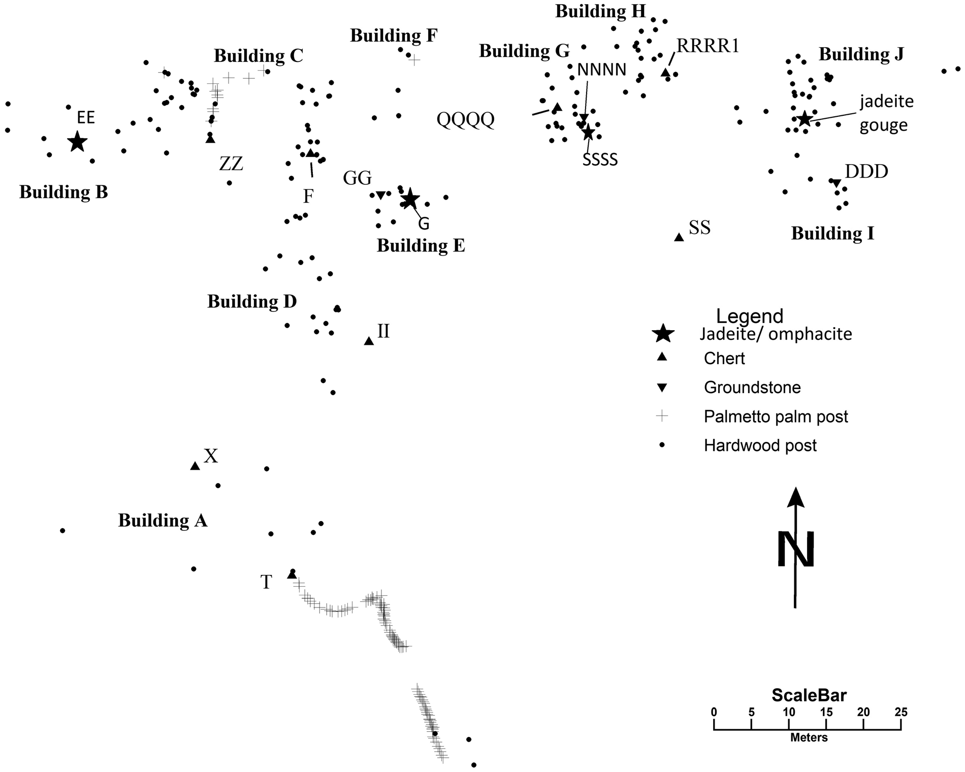
Stone artifacts, with catalog numbers. (a) F laurel leaf biface; (b) ZZ shouldered biface; (c) RRRR1 unifacial stemmed point; (d) T biface; (e) QQQQ large flake; (f) SS pock-marked unifacial stemmed point; (h) SSSS ground stone celt; (i) EE ground stone celt; (j) G ground stone celt; (k) II shouldered biface; (l) DDD mano; (m) jadeite gouge. (a–d, g, k) Drawings by Mary Lee Eggart. (e, f, h–j, l) Drawings and photographs byMcKillop.
Map of Ek Way Nal posts showing locations of stone artifacts, identified by catalog numbers. Map by McKillop.
Any fish or other animal bones would have been destroyed by the acidic matrix of the red mangrove peat, which also destroys calcium carbonate in marine shells and crushed limestone or dolomite temper in pottery. No fishing gear was found at Ek Way Nal, although a side-notched stone used as a fishing weight was found at Ta'ab Nuk Na (McKillop Reference McKillop2019:Figure 6.6). Fishing line made from spinning cotton may be evident from spindle whorls, such as one found at site 6 (McKillop Reference McKillop2019:Figure 6.17), but not at Ek Way Nal. Fish are abundant in the lagoon, including permit (Trachinotus falcatus), barracuda (Sphyraena barracuda), and Goliath grouper (Epinephelus itajara). Manatees (Trichechus manutus), American crocodiles (Crocodylus acutus), and jaguars (Panthera onca) are also found in the lagoon, so may have been processed at Ek Way Nal. On flotation survey in a shallow water lagoon near Ek Way Nal, there were jaguar paw prints in the sea floor. Crocodiles have been observed at Ek Way Nal. Manatee have been observed nearby. Fishing and hunting may have been carried out by other members of an extended family of salt workers, by the salt workers in the rainy season when salt production is not optimal (even indoors), or by fisher folk elsewhere, such as the nearby island of Wild Cane Cay. Fish bones, manatee bones, and other animal bones, as well as fishing weights, are plentiful in Late Classic midden deposits at Wild Cane Cay (Figure 2; McKillop Reference McKillop2005a:36–37).
Grinding Corn
Manos and metates are typical of households where grinding corn was a frequent activity. However, ground corn was also part of salt production at Sacapulas (Reina and Monaghan Reference Reina and Monaghan1981). At Sacapulas, when a ball of corn meal floats in the brine during brine enrichment, the brine is considered salty enough for boiling in the kitchen house. Corn meal was smeared on the inside of bowls to seal the containers before the brine was poured into them. Grinding stones were associated with Buildings E, G, and I (Figures 14 and 15).
Food Preparation
The diet included fish and tree fruits from the community and likely additional foods from elsewhere, such as corn. The presence of grinding stones supports this view. Endocarps from the native palms coyol (Acrocomia aculeata, also known as Acrocomia mexicana) and cohune (Attalea cohune, also known as Orbigyna cohune) were found at the site, and were common at other sites on the sea floor and in excavations (McKillop Reference McKillop2019:121–123, Figure 6.8). Although no fish or other animal bones were found, they would not have been preserved due to the acidic matrix of the red mangrove peat. Use-wear on three chert tools indicates that fish and meats were processed at Ek Way Nal (McKillop and Aoyama Reference McKillop and Aoyama2018).
Wood Working
Cutting trees and sharpening the ends of building posts required tools, as did the manufacture of various wooden objects. A laurel leaf chert biface in Building C, artifact F, has use-wear indicating that it was used to cut or whittle wood (Figures 14a and 15; McKillop and Aoyama Reference McKillop and Aoyama2018:Figure 4a). The rosewood handle (Dalbergia stevensonii) for the jadeite gouge in Building J was carved from a larger piece of wood (McKillop et al. Reference McKillop2019). Each of the wooden building posts was sharpened at the base before the post was driven into the ground during building construction.
The preferred woods for building construction at Ek Way Nal are Mouriri sp. (n = 64), Santa Maria (Calophyllum brasiliense; n = 26), and Chrysobalanaceae (n = 18), all available in the rainforest south of the sites; white mangrove (Laguncularia racemosa; n = 12) from the mangrove ecosystem; and Caearia sp. (n = 6) from the seaside (McKillop Reference McKillop2019:Figure 5.3, Table 5.2). Palmetto palms (Acoelorrhaphe wrightii; n = 109) were available on dry land inland from the mangroves, about 100 m from the water's edge. Rosewood (n = 1) was available in the rainforest south of the lagoon.
Ritual
Household ritual using figurines, censers, and candeleros was common at ancient Maya communities (Gonlin Reference Gonlin, Gonlin and Lohse2007; Halperin Reference Halperin2014). Rituals also may have been part of salt-making, as at Sacapulas, Guatemala, where there is a ritual at the beginning of each salt season, corresponding to the start of the dry season (Reina and Monaghan Reference Reina and Monaghan1981). Salt-making or household rituals at Ek Way Nal may have included ocarinas for music, figurines, and incense burners, as well as serving dishes for food and bowls for beverages. Belize Red serving bowl or dish sherds were found in all four phases in limited quantities. They are common in household deposits at Caracol and in the Belize Valley. Calabash (Crescentia cujete) bowls were preserved at several underwater sites in the lagoon, notably Stingray Lagoon and Eleanor Betty sites (McKillop Reference McKillop2019:130, Table 5.1).
Gonlin (Reference Gonlin, Gonlin and Lohse2007) suggests coyol wine may have been served in commoner household rituals at Copan. Coyol is a native palm fruit that is ubiquitous at the underwater sites, along with another native palm fruit, cohune. The inner hard endocarp shells preserve well. Perhaps coyol, corn, and/or chocolate drinks were part of rituals. Corn was excavated in Classic period middens on nearby Wild Cane Cay, along with coyol and cohune endocarps, mamey (Pouteria sp.) apple seeds, and nance (Byrsonima crassifolia) seeds (McKillop Reference McKillop1994). Coyol and cohune endocarps and mamey seed shell were radiocarbon dated to the Late Classic at another underwater site, Stingray Lagoon (McKillop Reference McKillop2019:Table 5.1). A cacao bean was preserved in waterlogged midden deposits below a coral rock platform at nearby Frenchman's Cay (McKillop Reference McKillop2005b). The mainland nearby is one of the main cacao-growing areas in the Maya region, with a large cacao farm currently in operation at the Late Classic site of Village Farm (Figure 2).
There are nine mapped ocarinas or figurines at Ek Way Nal (Figures 16 and 17). Ocarinas are common in Classic Maya households as part of domestic rituals (Halperin Reference Halperin2014; Halperin et al. Reference Halperin, Bishop, Spensley and Blackman2009). Phase 1 includes two boxers or helmeted figures (A and C head only) and a woman with a child (B) from Building B (Figure 17). They are Lubaantun-style ocarinas (Hammond Reference Hammond2017). Taube (Reference Taube, Renfrew, Morley and Boyd2018, Taube and Zender Reference Taube, Marc, Orr and Koontz2009) suggests boxers were involved in rain rituals at the start of the rainy season. Salt rituals at the beginning of the dry season are known for modern salt works at Sacapulas, Guatemala (Reina and Monaghan Reference Reina and Monaghan1981). Phase 2 does not have figurines, but few artifacts were surface collected in Building J. Phase 3 includes two ocarinas that each feature a woman and child, from Buildings C (E) and D (H), both larger than Lubaantun-style ocarinas, as well as a hollow-body ocarina (OOOO) from Building H. Phase 4 includes a figurine (KKK, NNN) made from the typical briquetage pottery, Punta Ycacos Unslipped. East of Building I there is a Lubaantun-style ocarina ball player head (BBB) and a female head and torso ocarina (AAA).
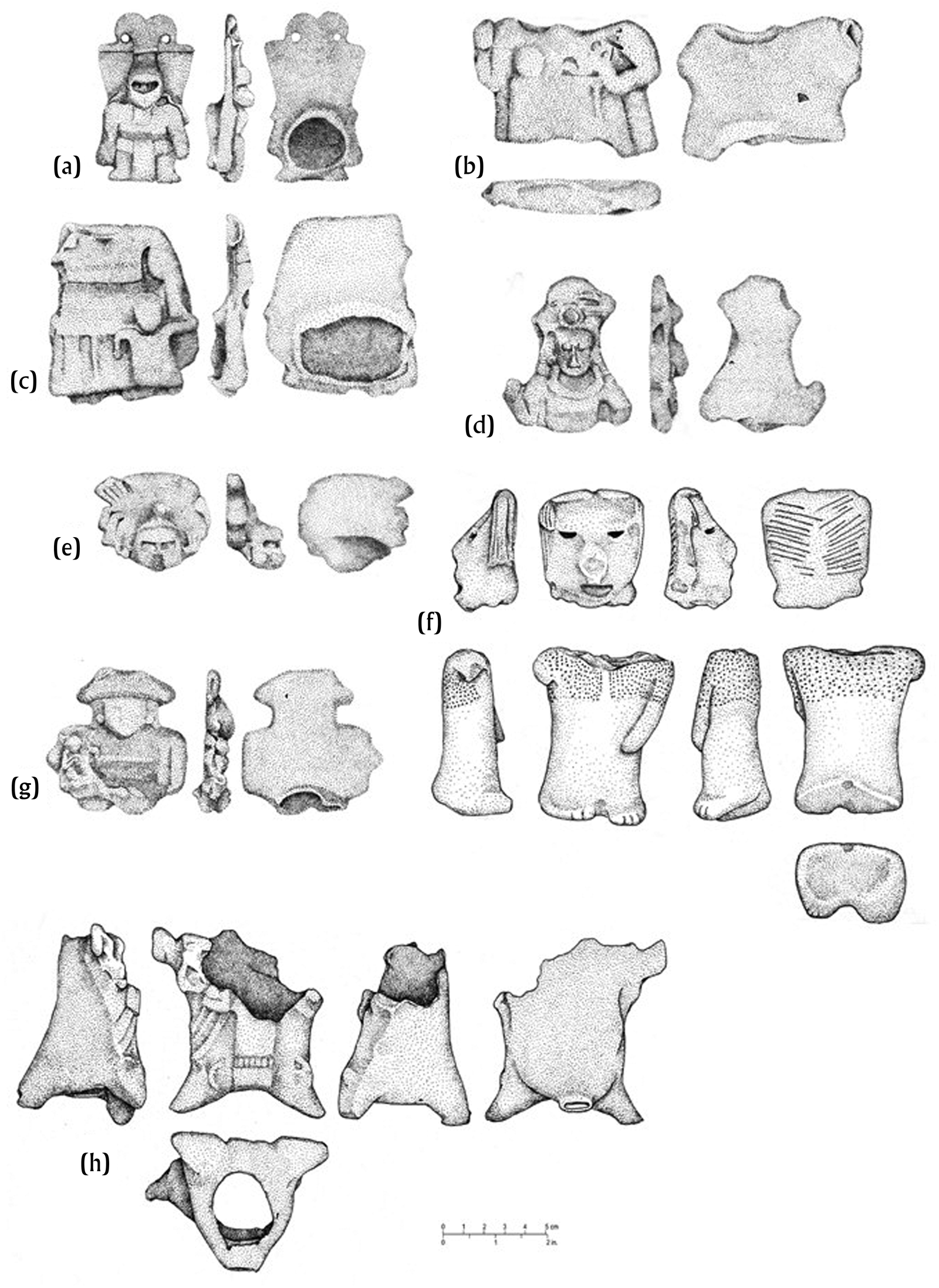
Ocarinas, with catalog numbers. (a) A boxer; (b) H woman with child; (c) B woman with child; (d) AAA woman; (e) C boxer head; (f) KKK and NNN Punta Ycacos Unslipped figurine; (g) E woman holding infant; (h) OOOO. Drawings by Mary Lee Eggart.
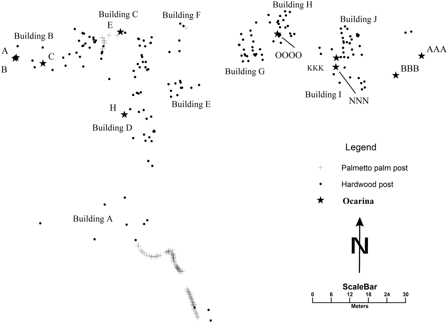
Map of posts at Ek Way Nal showing locations of ocarinas, identified by catalog numbers. Map by McKillop.
Censers and candeleros were used to burn incense (Figures 12 and 13). Censers at Ek Way Nal are large cylinders with lids made from Punta Ycacos Unslipped clay and quartz sand temper. Candeleros are small, flat-based containers. Phase 1 includes a censer base (UU) and a candelero (DD) from Building B. Phase 4 includes three censer lids from Building I, one with a handle (III) and two with modeled lizard decoration on the top (MMM and EEEE).
DISCUSSION
The ten buildings at Ek Way Nal were used at different times and for various purposes (Table 3). Householders engaged in numerous activities, including cooking, grinding corn, sharpening tools, and ritual. In contrast, surplus household salt production was carried out in salt kitchens, as known from modern and historical examples. Salt production, salting fish, wood working, and making the brine-boiling pots are considered contingent multi-crafting, since they are all part of the salt production process. Scaling, gutting, and cleaning fish or meat, as well as salting fish or meat, may have been part of household activities on a limited scale for household use. However, like salt production, surplus household production of salted fish or meat was likely carried out in specific locations outside homes, either in a yard or in a special structure. Most of the chert artifacts from various sites, including Ek Way Nal, that were part of a use-wear study indicated that they were used to cut fish or meat or to scale fish or scrape hides (McKillop and Aoyama Reference McKillop and Aoyama2018). Cutting and whittling wood also may have been part of household activities, including making handles for tools such as the jadeite gouge. However, every wooden building post was sharpened at the end driven into the ground and palm fronds were cut for thatching the salt kitchens, indicating that wood work was integrally connected to salt production. Warrie Red, often with unit-stamped decoration on the vessel shoulder, was the main storage container, for water, brine, or loose salt. The brine-boiling pots were locally made from clay and quartz sand temper available in the lagoon, and a pottery paddle from a nearby site indicates that production of the standardized salt pots was an activity contingent to salt production (McKillop Reference McKillop2019, Reference McKillop2021). In general, there is a lack of diversity of ceramic types and a focus on briquetage, which corresponds to expectations for surplus household salt production. The goal in discussing activities that took place at Ek Way Nal during each phase of construction is to consider whether any of the buildings may have been residential.
Activities associated with different buildings over time.
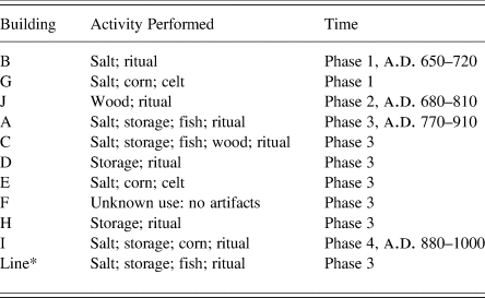
Notes: salt = salt making; storage = Warrie Red storage jars; fish = use-wear for processing fish; wood = use-wear for wood-working or wood artifact; corn = grinding stone; ritual = ocarina, incense burner, possibly celt, candeleros, and/or Belize Red serving bowl; Line* = line of palmetto palm posts.
Tools or other objects found in a particular building may have been in storage for use outside or indoors at a later time. Some objects may have been stored in rafters inside buildings, as at Cerén (Sheets et al. Reference Sheets, Dixon, Lentz, Egan, Halmbacher, Slotten, Herrera and Lamb2015), or in storage areas in buildings, as at Aguateca (Inomata et al. Reference Inomata, Triadan, Ponciano, Pinto, Terry and Eberl2002). The jadeite gouge found beside a post inside Building J may have fallen from a stored position (McKillop et al. Reference McKillop, Harlow, Sievert, Wayne Smith and Wiemann2019). Objects used in outdoor activities, such as salt-drying fish, were likely stored indoors, away from weather, children, or animals. Objects in salt kitchens at Sacapulas had storage and use areas inside the building, including piles of firewood, piles of broken brine-boiling bowls that had been removed from salt cakes, and large jars for storing brine and loose salt along the inside walls (Reina and Monaghan Reference Reina and Monaghan1981). The use area was the brine-boiling platform in the center of the building, with open space around for the salt workers to maneuver.
Phase 1
Buildings B and G were constructed in phase 1, during the early part of the Late Classic (Table 3). The radiocarbon date on building posts is corroborated by the presence of Late Classic, Lubaantun-style ocarinas, the absence of unit-stamping on jars, and the presence of Belize Red serving bowls or dishes. Lubaantun-style ocarinas are restricted to phase 1. Belize Red and the ocarinas link Ek Way Nal to Lubaantun at that time. Both buildings B and G have briquetage. Building G has a grinding stone and a greenstone celt. Building B is evaluated as a residence based on the ritual items, including censers, a candelero, and ocarinas, whereas Building G is interpreted as a salt kitchen.
Phase 2
Phase 2 includes Building J. The radiocarbon age is refined by the date on the rosewood handle for the jadeite gouge, which narrows the range to a.d. 680–810, placing the building in the Late Classic. The wooden posts from Building I overlap those from Building J, indicating that the buildings were not contemporaneous. Apart from the jadeite gouge and rosewood handle, the only artifact mapped in Building J is a Belize Red rim sherd (HHH) with incised and diagonal lines on the exterior (Figure 9). Building J is a candidate for a residence, since it has the jadeite gouge, which may be unexpected in a salt kitchen. The building is also located away from the center of salt production and salting fish to the west, mirroring a divided landscape at Sacapulas with salt kitchens near the salt spring and houses farther back.
Phase 3
Buildings A, C, D, E, F, and H were constructed during Phase 3. Buildings C, D, E, and F form a plaza group in the center of the site. Construction of the buildings occurred sometime from the end of the Late Classic to the Terminal Classic, based on radiocarbon dates of building posts. The dates are supported by the lack of Lubaantun-style ocarinas and the presence of unit-stamped jars (Buildings A, C, D, and H and the line of palmetto palm posts). The ocarinas in Buildings C (E) and D (H) are larger than Lubaantun-style ocarinas. The ocarina in Building H (OOOO) is a thin-walled, hollow body, also different from the Lubaantun-style examples. The use of similar unit-stamped decorations on the shoulder of Warrie Red storage jars ties Ek Way Nal to Nim Li Punit in Phase 3. The significance for the current study is that unit-stamped pottery has a restricted distribution on the coast and inland in southern Belize, the Maya Mountains, and adjacent Guatemala (McKillop Reference McKillop2002:82–83). Unit-stamped pottery was not made at Ek Way Nal due to lack of crushed limestone, dolomite, or other temper materials that are available inland (McKillop Reference McKillop2019:161). Buildings F and H are candidates for residences since they lack briquetage or evidence of salting fish.
Salt production, salting fish, and wood working are some of the activities that occurred at Ek Way Nal during Phase 3. Buildings A, C, and E have briquetage indicating that salt production took place. Buildings A and C also have Warrie Red storage jars for brine or loose salt. The grinding stone in Building E may indicate salt production or household use. Wood working existed in Building C or the tool was stored in the building, based on use-wear from a chert tool. Buildings A and C and the area adjacent to the line of palmetto palm posts have chert tools used to process fish or meat. The tools were either stored in the buildings or were used there.
In terms of ritual in Phase 3, Buildings C and D have figurines depicting a woman holding an infant, and Building H has a hollow figurine, none in Lubaantun style.
Phase 4
Phase 4 is represented by Building I, where briquetage is abundant and there is a grinding stone (DDD). Evidence for ritual includes three censers (MMM, III, and IIII) and a figurine (KKK, which joins NNN), all made from local Punta Ycacos ware (Figure 13). Unit stamping is popular and includes the S, reverse S, and comb stamped decorations on the shoulder of jars as well as thumbnail impressions (Table 2, Figure 11). Belize Red includes bowl rim YYY with gouges on a panel defined by horizontal incised lines (Figure 8c) and a bowl with a notched basal angle (Figure 8d).
Ek Way Nal may have supplied salt cakes and salted fish to Lubaantun, Nim Li Punit, and other inland communities at separate, periodic markets. The Ek Way Nal traders brought goods and food back to the salt works. Salt cakes may have been transported in sand-tempered bowls to Lubaantun, where Puluacax pottery comprises 14 percent of Hammond's (Reference Hammond1975) pottery. The rarity of Puluacax pottery at Nim Li Punit may reflect a change in the transport of salt cakes without bowls.
Lubaantun and Nim Li Punit were independent and fairly self-sufficient communities that lacked strong connections with each other. However, Ek Way Nal had ties to each, including unit-stamped and Belize Red pottery. The ties between the Paynes Creek Salt Works and Nim Li Punit are underscored by similarities in obsidian source use, with Ixtepeque being the main source used by both (McKillop Reference McKillop2019:Table 7.4), although no obsidian blades were found in the sea floor survey. This pattern linked the sites to Wild Cane Cay in the Terminal Classic, where Ixtepeque was also the preferred obsidian source material. In contrast, Lubaantun relied on El Chayal obsidian (Fauvelle Reference Fauvelle2012:90). Ties between Lubaantun and Ek Way Nal are the Lubaantun-style ocarinas.
CONCLUSIONS
Systematic sea-floor survey and mapping individual artifacts and posts embedded in the sea floor show patterns of different activities that underscore that Ek Way Nal was not just a series of salt kitchens. Expectations for a household assemblage, a salt kitchen assemblage, and a fish-salting assemblage of artifacts include different suites of artifacts for various activities (Table 4). A household assemblage is characterized by a diversity of pottery vessel forms for cooking, storage, water, and consumption. Stone tools, corn grinding stones, plant and animal remains, and evidence of ritual are expected, as are burials under house floors at nearby Wild Cane Cay (McKillop Reference McKillop2005a). In contrast, a salt production assemblage features a lack of diversity of ceramics and a focus on briquetage, as at the Yotot site, where 98 percent of the pottery from excavations was briquetage (McKillop and Sills Reference McKillop and Sills2016). A fish-salting assemblage includes tools for cleaning fish, a rack or box for salt drying, a lack of pottery, ritual, or diversity of artifacts, and fish bones, either indoors or in a yard.
Archaeological correlates of household, salt kitchen, fish processing, and brine enrichment activities.
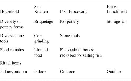
The lack of burials, fish, or other animal remains is expected at Ek Way Nal, since the acidic red mangrove peat does not preserve anything made from calcium carbonate. The sea-floor survey did not recover clear evidence of burial goods even in the absence of preserved skeletal remains. Ritual items can be associated with household or community ritual or with salt rituals, so their common occurrence at the site is not helpful in distinguishing residences from salt kitchens. The presence of briquetage and lack of diversity of other pottery indicate that Building G may have been a salt kitchen in Phase 1, during the early part of the Late Classic. Building J may have been a residence in Phase 2 based on the occurrence of the jadeite gouge with its rosewood handle. Buildings F and H are candidates for residences in Phase 3 when six buildings were constructed, based on the lack of briquetage or evidence of salting fish. Buildings C to F form a plazuela group. Along with the area extending to the line of palmetto palm posts, the buildings include an indoor and outdoor area for fish processing on the south and an area to the north for salt production. Building I dates to Phase 4 and has abundant briquetage, indicating that salt production was the main activity.
Studies of the organization of production in ancient complex societies such as the Classic Maya include factors such as intensity, context, concentration, constitution, and scale (Costin Reference Costin and Schiffer1991). Salt production at Ek Way Nal was likely full-time during the four-month dry season, with some production as needed during the rainy season, following the model of Sacapulas, where salty soil is stored in the salt kitchens for use during the rainy season. Following Hirth's (Reference Hirth and Hirth2009) terms, salt production was part of contingent multi-crafting. In addition to making salt, other related or contingent activities included maintenance of buildings and canoes, selection and transport of wood for construction and other wood working, pottery production, and salting fish. There is no indication of elite supervision on site or remotely, indicating that salt production was independent, instead of being part of “attached production” for the elite: there is no evidence of elite residences at Ek Way Nal or large sites where elite may have lived (McKillop Reference McKillop2019; Watson and McKillop Reference Watson and McKillop2019). The buildings at Ek Way Nal were nucleated and near the salty water resource for salt production, as opposed to dispersed. The constitution of production was based on kin-based, surplus household production, with residences located near salt kitchens. The scale of production needs to be determined by excavation and within the context of the other Paynes Creek Salt Works. Since the Ek Way Nal buildings were constructed and used over time from the Late to the Terminal Classic, the scale of salt production is less than if the buildings were all used at the same time. At least one salt kitchen was in use from the Late to Terminal Classic (Table 3). Based on the density of briquetage on the surface from this study and from a previous general surface collection at Ek Way Nal (McKillop Reference McKillop2021) and at other sites in the lagoon system (McKillop Reference McKillop2002; Sills and McKillop Reference Sills and McKillop2018), brine-boiling used standard-sized vessels, suggesting mass production of the product, salt (McKillop Reference McKillop2002).
Transport of loose salt in baskets or other perishable containers, or as salt cakes to other communities, including up rivers to inland marketplaces, may have been carried out by members of the extended households (McKillop Reference McKillop2019). The presence of Belize Red, Warrie Red, and other nonlocal pottery, chert from Colha or elsewhere in the northern Belize chert-bearing zone, and jadeite and omphacite from the Motagua River (Figure 14; McKillop et al. Reference McKillop, Harlow, Sievert, Wayne Smith and Wiemann2019) indicate Ek that Way Nal was a community well-integrated into waterborne transport and trade along rivers and the coast. Nonlocal goods and resources were evenly distributed among households, as is expected for participation in a marketplace economy (Cap Reference Cap and King2015; Chase et al. Reference Chase, Chase, Terry, Horlacher, Chase and King2015; Masson and Freidel Reference Masson and Freidel2012).
Caracol may have controlled a trade route that included Belize Red vessels arriving from the Belize River valley and moving south along the edge of the Maya Mountains to southern Belize (Chase and Chase Reference Chase and Chase2012). Belize Red was first traded to inland sites in southern Belize about a.d. 780–790 (Irish and Braswell Reference Irish and Braswell2013:273), but Belize Red was earlier on the coast at Ek Way Nal. An east–west trade route from the interior of Guatemala to the coast via the Sibun River was also controlled by Caracol. Belize Red was used in burials at Caracol and in the lower Belize Valley at Baking Pot and Barton Ramie, but not in the upper valley where it was in domestic contexts. Belize Red was virtually absent at Tikal and Uaxactun and from the Rio Hondo–Rio Azul trade route in northern Belize. Belize Red is also found at Lubaantun and Nim Li Punit (Fauvell Reference Fauvelle2012:Table 1; Hammond Reference Hammond1975).
This study shows that analysis of individually mapped wooden building posts and artifacts on the sea floor indicates temporal and spatial patterns of ancient activities related to the surplus household production of salt at Ek Way Nal during the Late to Terminal Classic periods. Over the course of four successive building construction phases, there were likely separate residences and salt kitchens. Other related activities, including salting fish, wood working, grinding corn, and rituals pertaining to the needs of householders and salt kitchen workers, occurred both indoors and outdoors. Some activities, notably salt-drying fish, were part of the surplus salt production and can be described as contingent multi-crafting. Other activities, such as rituals, eating, or wood working, were carried out in households as part of everyday life. The interpretations are facilitated by the rich ethnographic record of salt production by the brine-boiling method, the material remains of brine-boiling as briquetage, and the unusual environmental condition that preserved the wooden buildings.
RESUMEN
Para los mayas clásicos, el excedente de producción familiar era fundamental para abastecer a otros hogares dentro de una comunidad y para obtener otros bienes y recursos fuera de la comunidad, a menudo a través del comercio en el mercado. En este artículo, la rara conservación de edificios de madera debajo del lecho marino, que también están asociados con artefactos, se utiliza para evaluar la producción familiar excedente de sal en la economía maya del clásico tardío al terminal (600–900 d.C.). Las expectativas de artefactos asociados con diferentes actividades forman la base de una discusión sobre conjuntos de artefactos para residencias, cocinas de sal y talleres de salazón de pescado. Se discute un estudio de caso para el sitio maya submarino de Ek Way Nal, una de las salinas de Paynes Creek en Belice, que tiene cientos de postes de madera preservados en turba de mangle rojo (Rhizophora mangle), debajo del lecho marino. Los postes forman las paredes de edificios de diez postes y techos de paja con artefactos asociados incrustados en el fondo del mar. Dado que la madera normalmente se descompone en el paisaje tropical de América Central, los postes de madera y los artefactos asociados brindan la oportunidad de examinar las actividades en los edificios con postes y paja construidos directamente en la superficie del suelo, a menudo denominados “estructuras invisibles.” El estudio de flotación sistemático sobre el sitio, marcando los artefactos y postes individuales y mapeándolos, brindó la oportunidad de examinar los patrones espaciales de las actividades. Se describen los métodos de campo, junto con el poste de madera y los artefactos. Los diez edificios se asignan a diferentes fases de construcción en función de las fechas de radiocarbono en los postes de los edificios. Las fechas de uso se asignan en función de la variedad de tipos y los análisis modales de la cerámica. El sitio incluĭa residencias, cocinas de sal y locales para actividades asociadas, en particular el procesamiento de pescado y el trabajo de la madera.
ACKNOWLEDGMENTS
Fieldwork was carried out with permits from the Belize Institute of Archaeology and with encouragement and assistance from Dr. John Morris, Dr. Jaime Awe, and Institute staff. The fieldwork was supported by NSF grant 0513398 “Mapping Ancient Maya Architecture on the Sea Floor, Belize” to H. McKillop. Radiocarbon dating was supported by NSF grant 1826653 “Labor Relations in a Traditional Complex Society” to H. McKillop and E. Sills. We appreciate the field team that included the authors, along with Bretton Somers, Mark Robinson, Amanda Evans, and John Young. We are grateful to our host family in Belize, Tanya Russ and John Spang, and to Celia Mahung and staff of the Toledo Institute for Development and the Environment (TIDE) who co-manage Paynes Creek National Park. To the people of Punta Gorda we owe friendship and tremendous gratitude for your interest in the archaeology of the coastal waters north of your town.


 Open access