Introduction
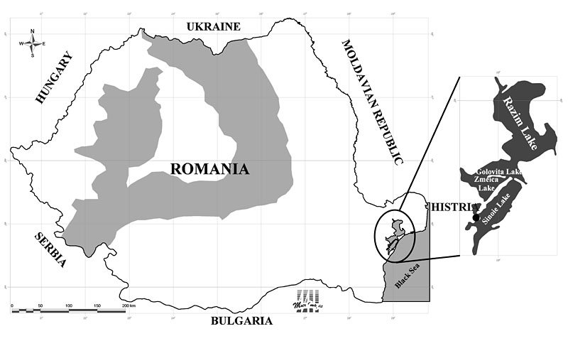
Location of Histria (west of the Black Sea).

Histria, a Millesian colony founded around 657-6 BC (Reference ErhardtErhardt 1983) on the western Black Sea coast, was situated near the mouth of the Danube (Figures 1 & 2) and took its name from the river Istros. Together with Orgame-Argamum, an Ionian colony situated to the North, Histria is part of the oldest wave of Greek colonisation on the western and northern Black Sea coast (Tsetskhladze 1998). The history of this Ionian colony covers 14 centuries, starting with the Greek, Hellenistic, Roman and Late Roman periods and ending at around AD 610. The topography of the Hellenistic and Roman town is relatively well-known (Figure 3). Archaeological, epigraphic and numismatic discoveries made over the course of a century and published in over 300 articles, studies and monographs have contributed substantially to the dissemination of important aspects of the Greek and Roman colonial world. Those aspects include Greek and Latin epigraphy, Greek sanctuaries, Hellenistic and Roman pottery, Greek and Greco-Roman sculpture and early Christian architecture (Reference AlexandrescuAlexandrescu 1999). As with all Ionian colonies, the site upon which Histria was founded near the mouth of the Danube was favoured by natural factors, including: excellent conditions for the installation of a harbor; quality land for agriculture and forest-covered hills; excellent water sources; limestone quarries; copper and iron mines, and sources of clay, wood and fish. To the north, the town limits extended to the Danube Delta and included Halmyris, the old bay today called Razim.
Scythia Minor in the Greco-Roman Period.

View over Histria.

The Chorothesy, discovered at Histria in 1914, in which M. Laberius Maximus, the governor of Moesia, established the boundaries of the Histrian territory on October 25th AD 100.

New research
The new research initiative has been directed at the understanding of the chora, the hinterland of the town. The Chorothesy, the famous inscription discovered at Histria in 1914, provides a major asset in this respect (Reference PippidiPippidi 1983: 67). In this exceptionally significant epigraphic document, unique in the Pontic area, M. Laberius Maximus, the governor of Moesia, established the boundaries of the Histrian territory on October 25th AD 100 (Figure 4). Archaeological and geo-morphological research has also been applied to the territory of the town, starting from geo-morphological (Reference RomanescuRomanescu 2005), topographical (Reference AvramAvram 1990) and economic foundations (Reference BounegruBounegru 2006). In 2007, a new project The Resource Catchment Area of Graeco-Roman Histria: an ecochronological Approach was accepted for financing within the Exploratory Research Projects Program 2007-2010 (National Council of Research in Higher Education of the Ministry of Education and Research in Romania). Here we offer a preliminary account of the work.
Objectives & methodology
The main objectives of the project are:
-
1. To identify the natural resources of the Histrian territory in the Greek and Roman periods.
-
2. To establish the geographical extent of the natural catchment area and to highlight the dynamics of exploitation.
-
3. To establish the role of natural resources in the development of the human habitat.
-
4. To determine a settlement typology and function through time.
-
5. To build a model of the exploitation of the natural resources in the Histrian territory and to check its applicability to similar cases in the Pontic and Mediterranean regions.
The methodology has four levels:
-
1. The mono-disciplinary level: the use of GPS, the application of classical and satellite photogrammetry and the application of archaeological survey.
-
2. The multidisciplinary level: the analysis of ancient texts on territorial boundaries, and the application of spatial and viewshed analysis methods to verify the Aristotelian theory of the visual control of Greek colonial territory.
-
3. The interdisciplinary level: the comparison of the catchments of the Greek and Roman colonial territories.
-
4. The transdisciplinary level: the study of literary and epigraphic sources, in conjunction with archaeological, landscape, geographical analysis and satellite photography, in order to deduce the control exercised by the central urban settlement.
Results
We have so far identified 84 ancient settlements, sanctuaries, necropoleis, fortified settlements, farms and aqueducts in the Histrian territory dating from the Greek, Hellenistic, Roman and Roman-Byzantine periods, as well as the vestiges of the ancient Histrian harbour. Stone quarries, copper and iron mines, traces of iron and clay exploitation and a few Roman aqueducts that supplied water to the town were also identified and located (Figure 5). Systematic and surface archaeological research have confirmed the fact that during the Hellenistic and Roman periods the territory of the town (the chora) stretched west and south to the Calabeus river in Chorothesy, and north to the Danube Delta.
Histrian territory.

The visibility limits of the natural boundaries of the Histrian territory.

Visibility studies (Figure 6) show a strong coincidence between the settled areas and the territory visible from the town. This explains to a great extent the direct control Histria had over the resources of the area and confirms the close relation existing in a Greek colony between the town and the territory.
Acknowledgements
Our thanks go to the National Council of Research in Higher Education of the Ministry of Education and Research in Romania for supporting this Project completely.