


Introduction
Lynchets cover significant areas of northern Europe (Brown et al., Reference Brown, Walsh, Fallu, Cucchiaro and Tarolli2020: 566–67) but they have rarely been subjected to direct archaeological investigation (Brown et al., Reference Brown, Fallu, Walsh, Cucchiaro, Tarolli and Zhao2021: 2). Strictly speaking, lynchets are defined as created by medieval strip farming and ploughing along slope contours (cultivation lynchets; see Curwen, Reference Curwen1939: 46) but the term has been widely applied to small agricultural terraces without walls (Froehlicher et al., Reference Froehlicher, Schwartz, Ertlen and Trautmann2016: 173–85) and this is the definition we apply here. Lynchets and terraces present the most widespread geo-anthropological elements of landscape transformation prior to modern times (Figure 1). Here, we present the results of a detailed geoarchaeological investigation of the age, form, and function of lynchets within three typical lowland chalk systems.
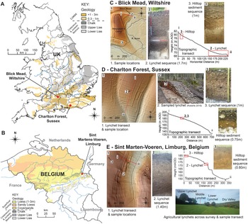
Distribution of European loess (based on Catt, Reference Catt, Lerman and Meybeck1988; Lehmkuhl et al., Reference Lehmkuhl, Nett, Pötter, Schulte, Sprafke and Jary2021), lynchet and terrace ‘common’ distribution, and location of case studies.

Unlike steep-land agricultural terraces, which have recently received considerable archaeological attention (Harfouche & Poupet, Reference Harfouche, Poupet, Arnoldussen, Johnston and Løvschal2021; Turner et al., Reference Turner, Kinnaird, Varinlioğlu, Şerifoğlu, Koparal and Demirciler2021; Brown et al., Reference Brown, Fallu, Cucchiaro, Alonso, Albert and Walsh2023), lowland lynchets on soft rocks (e.g. chalklands) have seen relatively little modern scientific analysis. Although commonly described by nineteenth-century antiquarians, lynchets were not systematically studied until the development of aerial photographic archaeology in the 1920s (Crawford, Reference Crawford1923). This led to further work on their form within the wider historical landscape (Curwen, Reference Curwen1939: 45–52). By the 1960s, the analysis of the composition and distribution of lynchets across the UK and northern Europe demonstrated concentrations across steeper hillside landscapes with shallow soils over limestone geologies, particularly chalk (Whittington, Reference Whittington1962: 117; Fénelon, Reference Fénelon1963: 24–28); much debate has centred on when these features were formed (Macnab, Reference Macnab1965: 279–90; Fowler & Evans, Reference Fowler and Evans1967: 289–301; Baker, Reference Baker1969: 136–40).
More recently, geomorphological research in these areas has made it possible to date soils, given the presence of windblown silts (loess) which are highly fertile and can be accurately dated by sediment luminescence (Stevens et al., Reference Stevens, Sechi, Bradák, Orbe, Baykal and Cossu2020: 3–4), in turn allowing for a better understanding of the historic formation of lynchets and increased potential of soil erosion (Evans et al., Reference Evans, Collins, Zhang, Foster, Boardman and Sint2017: 49–51; Verhegge & Delvoie, Reference Verhegge and Delvoie2021: 1–2). A greater understanding of formation processes and prehistoric land use across the chalklands of southern Britain (Bell, Reference Bell1986: 72–73; Johnston et al., Reference Johnston, May and McOmish2020, Reference Johnston, May, McOmish, Arnoldussen, Johnston and Løvschal2021: 185–207) and continental Europe (Rommens et al., Reference Rommens, Verstraeten, Peeters, Poesen, Govers and Van Rompaey2007: 784–87; Fuchs & Lang, Reference Fuchs and Lang2009: 22–24; Turner et al., Reference Turner, Kinnaird, Varinlioğlu, Şerifoğlu, Koparal and Demirciler2021: 784–87), mapping, and morphological assessments of buried soils and lynchets have documented the progressive development, erosion, and redeposition of brown earth soils, calcareous colluvium, and agricultural horizons across these landscapes (Ford et al., Reference Ford, Bowden, Gaffney and Mees1990: 44–51; Macphail et al., Reference Macphail, Courty and Gebhardt1990: 53–69; Allen, Reference Allen, Bell and Boardman1992: 37–52; Bell et al., Reference Bell, Black, Maslin and Toms2020: 1–8).
The term lynchet has been used across northern Europe for small unwalled contour ridges created by the ploughing of strip fields. They have been identified in France (Schwartz et al., Reference Schwartz, Robin, Adam, Schaeffer, Gebhart and Herrault2020; Keller et al., Reference Keller, Harrault, Schwatrz, Rixhon and Ertlen2023; Etrlen et al., Reference Etrlen, Keller, Vincent and Schwartzin press), Denmark (Nielsen & Dalsgaard, Reference Nielsen and Dalsgaard2017), Germany (Larsen et al., Reference Larsen, Robin, Heckmann, Fülling, Larsen and Bork2016), Poland (Sobala, Reference Sobala2021), and Czechia (Zádorová et al., Reference Zádorová, Penížek, Žížala, Matějovský and Vaněk2018; Zacharová et al., Reference Zacharová, Riezner, Elznicová, Macová, Kubát and Holcová2022) as well as England and Belgium. In some of these cases, such as the Danish and British ‘Celtic’ fields, lynchets are part of prehistoric field systems (Arnoldussen et al., Reference Arnoldussen, Johnstone and Løvschal2021), but this is not typical. Hence the examples presented here are not part of prehistoric field systems.
The Distribution of Lynchets in England
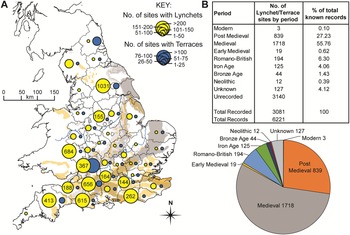
England's Historic Environment Record (HER) provides spatial information on terraces and lynchets and reveals distinct relationships with their underlying geology (Figure 2). Lynchets are recorded more often (n = 5657) than terraces (n = 564) and this reflects the nature of the low-relief soft-rock landscape of England and the terminology used by the Ordnance Survey and aerial photographic surveys (Crawford, Reference Crawford1923). With this caveat in mind, the results demonstrate distinct clustering of lynchets in southern England across areas with both Jurassic limestone and Cretaceous chalk bedrock. The frequency of lynchets in the southern and south-western counties reflects the presence of chalk and Jurassic limestones in the North and South Downs, Salisbury Plain, the Chiltern Hills, and Cranborne Chase. Although less common, terraces have a similar distribution, except for Northumberland, where there is a greater number recorded over lynchets.
A: distribution of lynchet (n = 5657) and terrace (n = 564) sites based on HER data with underlying Jurassic and Cretaceous limestone bedrock by county across England; B: number of lynchet/terrace sites by period across England.

Dating lynchets has been problematic (see Johnston et al., Reference Johnston, May, McOmish, Arnoldussen, Johnston and Løvschal2021: 185–207). Both form and archaeological associations have been most commonly used. About half the HER records have associated dates; of these, over half (56 per cent) suggest that both lynchets and terraces originated in the medieval period (ad 1066–1540), and a further twenty-seven per cent date to the post-medieval period (ad 1540–1750). This is, however, likely to be a considerable overestimation and probably reflects the re-use of older sites. The few excavations undertaken have yielded more early dates than the twelve per cent recorded for the Bronze Age to early medieval periods in the HER. For example, extensive landscape surveys and scientific analysis of field systems on the Berkshire Downs around Lambourne demonstrated that lynchets were created during the Romano-British period (Ford et al., Reference Ford, Bowden, Gaffney and Mees1990: 44–51; Bowden et al., Reference Bowden, Ford and Mees1993: 109–33). More recently, the refinement in optically stimulated luminescence (OSL) dating has allowed both lynchets and terraces to be dated more reliably (Brown et al., Reference Brown, Walsh, Fallu, Cucchiaro and Tarolli2020: 575). At Lyminge, Kent, OSL was used alongside traditional geoarchaeological methods to date trackways bounding lynchets to the late prehistoric and Romano-British periods (Bell et al., Reference Bell, Black, Maslin and Toms2020: 4–8). OSL has also successfully been used to date and understand the field boundaries of Cornwall (Vervust et al., Reference Vervust, Kinnaird, Herring and Turner2020a: 428–31) and northern England (Vervust et al., Reference Vervust, Kinnaird, Dabaut and Turner2020b: 64-68). In the Ingram Valley in Northumberland, a mix of OSL, radiocarbon, and hydrogen pyrolysis (HyPy) radiocarbon dating (Ascough et al., Reference Ascough, Bird, Brock, Higham, Meredith, Snape and Vane2009) has revealed that terraces were created in the Early Bronze Age (Brown et al., Reference Brown, Fallu, Cucchiaro, Alonso, Albert and Walsh2023: 352).
The Distribution of Lynchets in the Low Countries
In Belgium and the Netherlands, the greatest concentration of lynchets is found across the chalk and loess dominated central belt (Langohr, Reference Langohr, Cahen and Otte1993; Meijs, Reference Meijs2002; Van den haute et al., Reference Van den haute, Frechen, Buylaert, Vandenberghe and De Corte2003; Vancampenhout et al., Reference Vancampenhout, Langohr, Slaets, Buurman, Swennen and Deckers2013) and the Limburg Hills. These features, known as ‘graften’ or ‘graaf’, are derivatives of ‘graven’ or ‘graben’ (to dig), and the etymology, alongside historical research, suggests major anthropogenic formation (Alleijn & Saris, Reference Alleijn and Saris1980; Van Westreenen, Reference Van Westreenen2008: 183-88). Both cartographic and placename evidence suggests they date from at least the medieval period and that they were elements of common small-scale grazing systems when not being cultivated, and that the risers (in contrast to the horizontal beds) could provide wood and other shrub resources (Van Westreenen, Reference Van Westreenen2008: 183–88). However, the nature of the underlying chalk and limestone has led some scholars to infer a natural origin based on stratigraphic bedding (Kuyl & Felder, Reference Kuyl and Felder1968: 116–22).
The formation of the lynchets across the Belgian and Dutch Limburg has been attributed to an increase in population in the Iron Age (Dirkmatt, Reference Dirkmatt and Dirkmatt2006: 197–201). The development and use of lynchets in the Roman and medieval periods have also been attributed to increases in viticulture, particularly for the south-facing Limburg examples at Kolmont, Overeys, and Wahlwiller (Dirkmatt, Reference Dirkmatt and Dirkmatt2006: 197–201). Nyssen et al. (Reference Nyssen, Debever, Poesen and Deckers2014: 172) also suggest that lynchet formation must have taken place in the Gallo-Roman and medieval periods due to increased soil erosion from agricultural cultivation, and because similar practices have also been shown to have existed over large areas of the Low Countries (Van Oost et al., Reference Van Oost, Van Muysen, Govers, Deckers and Quine2005: 193–203). Across the Lanakerveld area of Maastricht in the southern Netherlands, lower gradient lynchets are only visible as subtle surface earthworks due to extensive soil erosion (Meurkens et al., Reference Meurkens, van Wijk, de Bruin, Hemminga, van Hoof and Knippenberg2009: 49–52). Indeed, the modernization of cultivation techniques after ad 1900 and land consolidation after ad 1950 led to the loss of more than half the Dutch lynchets in the twentieth century (Baas et al., Reference Baas, Groenewoudt, Jungerius and Renes2012: 9). Multidisciplinary research on lynchet formation processes at Groensdael has proposed that they result from downslope sediment erosion and colluviation driven by arable cultivation and water transfer over the last millennia (Nyssen et al., Reference Nyssen, Debever, Poesen and Deckers2014: 172–73). Since this estimate is based on tillage translocation rates generalized from Ethiopia, one of the aims of our research was to test this predicted age in an analogous system close to Groensdael.
Material and Methods
Detailed methodological descriptions of all analytical techniques are given in the online Supplementary Materials, with only brief descriptions here. Lynchet morphology was identified by a combination of airborne laser scanning (or LiDAR), unmanned autonomous vehicle (UAV) photography using structure-from-motion (SfM), and terrestrial laser scanning (Cucchiaro et al., Reference Cucchiaro, Paliaga, Fallu, Pears, Walsh and Zhao2021).
Soil and sediment sampling from lynchets and control profiles was conducted from archaeological excavations, test pits, and boreholes. Sequences were hand-excavated back to clean, undisturbed layers before graphic and descriptive recording, field analysis, and monolith sampling of the complete sedimentological sequences.
Sediment samples were analysed using loss on ignition (LOI) for organic, carbonate, and dry bulk density, magnetic susceptibility (MS), particle size analysis, portable X-ray fluorescence (pXRF), portable optically stimulated luminescence (pOSL), and soil micromorphology to investigate soil and sediment history. Direct dating was conducted using OSL (Table 1) of the silt-sized quartz fraction, following Shen et al. (Reference Shen, Mauz, Lang, Bloemendal and Dearing2007).
Summarized OSL and radiocarbon dates from the sampled lynchet sequences across the three locations (for full table, see Supplementary Material Table S1). * = Roberts, Reference Roberts2019.

Site-Based Results and Interpretations
Results and interpretations of the scientific data from the three case study areas are discussed alongside hilltop control locations, and more detailed analysis and discussion from the three sites is present in the Supplementary Material (S11–14).
Blick Mead lies on the eastern edge of the Stonehenge World Heritage site (Figure 3a and c), with subtle, low-angle lynchets developed within a dry valley from eight to nine per cent. The largest lynchet was present at the edge of the River Avon floodplain at the toe-end of a dry valley where it rose to a maximum of 1.70 m above the Middle-Upper Cretaceous chalk bedrock (Figure 3, c2) and preserved a unique Mesolithic occupation site (Jacques et al., Reference Jacques, Phillips and Lyons2018).
A and B: lynchet sample locations across England and Belgium in relation to underlying limestone geology and loess; C: detailed location and information for samples from Blick Mead, Wiltshire (lat.: 51.177313, long.: -1.7884306); D: Charlton Forest, W. Sussex (lat.: 50.932239, long.: -0.69141984); E: Sint Marten-Voeren, Belgium (lat.: 50.738762, long.: 5.8074479).

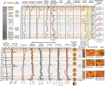
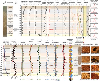
Sedimentological analysis of the sequence demonstrated a complex stratigraphy (Figure 4) with evidence of a thin pre-lynchet loessic soil above the chalk. The onset of lynchet formation was OSL dated (SBG080 and SBG086) to the Middle to Late Bronze Age and composed of weakly banded sandy silt-clay horizons (Table 1, Supplementary Material, Table S1). Over time, sedimentation upon the lynchet shifted between coarser material, possibly reflecting increased cultivation activity, and finer more organic horizons, suggesting reduced cultivation, surface weathering, and the erosion of arable soils between the Early and Middle Iron Age (SBG090).
Profile sedimentological analysis of the lynchet sequence at Blick Mead, Wiltshire, England.

The sedimentary record changed markedly in the upper metre of the sequence, suggesting a return to more intensive cultivation from the Middle Iron Age to the medieval period. Inititially there is distinctive cyclical deposition of coarser and finer sediments demonstrating cultivation/tillage and erosion across the site with varying degrees of intensity through the late prehistoric and early historic periods. An additional OSL date (SBG084) at the southern end of the lynchet (Table S1), dated to ad 290–470, implies enhanced lynchet formation in the Late Romano-British period, and the presence of greater amounts of degraded microcharcoal particles, organics, and carbonate may also indicate deliberate anthropogenic additions to the soils to increase or maintain fertility.
In the uppermost section of the lynchet there is a phase of considerably coarser sedimentation dating to between the eleventh and fifteenth centuries ad (SBG094, 096). This darker, more organic horizon demonstrates clear evidence of regular modification and mixing through cultivation (Figure 4, slide 30–37 cm).
The intensification of agricultural practice across the site during the medieval period may be related to the refounding of Amesbury Abbey in ad 1177 (Norton, Reference Norton2014). The development of an organic-rich, stoneless topsoil and subsoil most probably represents the reduction and, finally, the cessation of cultivation on the lynchet in the last 500 years. This may have been due to a shift from arable to pastoral land use in the post-medieval period caused by the Reformation and development of formal gardens in the eighteenth century ad.
The co-axial lynchet system at Charlton Forest, W. Sussex, was laid out on the undulating dip slope (8–9 per cent) of East Dean Woods within the South Downs in the upper Lavant valley, between the villages of Upwaltham and Singleton (Figure 3a and d). The lynchets, presently covered by post-war beechwood forestry with subordinate softwoods, were originally identified between Arundel and Harting in the early twentieth century (Wyatt, Reference Wyatt1927). Curwen (Reference Curwen1929: 93–95) also noted them, but these features were largely ignored in favour of more prestigious monuments such as enclosures, barrows, and hillforts. More recently the full extent of the lynchets has been revealed by high-resolution LiDAR (Manley, Reference Manley2016). The LiDAR survey and associated excavation have revealed an extensive former agricultural landscape and other prehistoric features including Bronze Age barrows and burnt mounds, a possible Iron Age banjo enclosure, and a Romano-British temple. Initial analysis and dating of the lynchets suggest agricultural activity during the Iron Age and Romano-British periods (Roberts, Reference Roberts2019).
Sedimentological analysis of a 1 m-deep lynchet revealed a complex depositionary sequence and formation history (Figure 5). Above the basal chalk, a cultivated loessic deposit was identified with radiocarbon dating (SUERC-67326) (Roberts, Reference Roberts2019) suggesting that agricultural practice probably began in the Middle to Late Bronze Age (Table 1). The sediment properties of the initial agrarian activity reflects the direct cultivation of an original in situ loess-derived deposit, with a thin residual degraded soil horizon towards the top indicating the remnants of a prehistoric land surface.
Profile sedimentological analysis of the lynchet sequence at Charlton Forest, W. Sussex, England.

From the Late Bronze Age onwards (SBG117) into the Iron Age, there appears to have been a progressive increase in cultivation activity and the deliberate input of both inorganic loessic material and organics to increase soil depth and fertility, a technique used widely across the north-western loess regions of Europe (Vanwalleghem et al., Reference Vanwalleghem, Poesen, Vitse, Bork, Dotterweich and Schmidtchen2007: 583).
In the upper half of the lynchet, the sediment sequence displays more cyclical silt-dominated layers and coarser horizons reflecting phases of reduced activity and possible soil development and increased cultivation practice and heightened erosion throughout the Iron Age and Romano-British period, as suggested by the presence of ceramics.
Following this, the sustained increase in coarser lynchet sediment, anthropogenic indicators (degraded carbonized and organic fragments), and ceramics indicated an increase in cultivation activity up to the Late Romano-British period (SBG120). The absence of pottery post-dating the late third century ad, though, suggests that cultivation had ceased well before the enclosure and afforestation with closed-canopy woodland associated with the creation of the Forest of Arundel in the twelfth century ad, marked by the development of the fine-grained surface topsoil and subsoil.
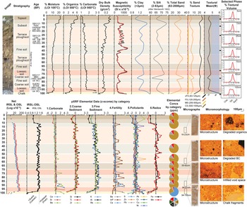
Sint Martens-Voeren in Limburg, Belgium, is located on the eastern edge of the Central Belgian loess belt. It has large lynchets at the junction between the steepest mid-valley Middle-Upper Cretaceous chalkland slopes (11.5 per cent) and the valley floor (Figure 3b and e).
Detailed analysis of the central lynchet revealed a 1.40 m sediment sequence and deposition from the late prehistoric period onwards (Figure 6). OSL dating towards the base of the lynchet (SBG124) indicated that agricultural practice and lynchet formation began before the Roman period, with early cultivation occurring on a pre-existing in situ loessic soil.
Profile sedimentological analysis of the lynchet sequence at Sint Martens-Voeren, Limburg, Belgium.

Initial development of the lynchet appears to have been dominated by the gradual accretion of finer and coarse sediment deposition. These suggest continued but reduced cultivation and possibly more regular fallow periods (e.g. rotations). However, a clear sedimentological transition occurs at 0.80 m, indicating a change in this practice. Overall, the sequence becomes coarser, with changes in analytical results suggesting a change in source material provenance and agricultural practice. Although not directly dated, this may equate to the intensification of land use in the later Roman period.
Above this sediment, texture shifts again towards finer sedimentation, with analysis suggesting a reduced phase of cultivation intensity, and possible soil development. Finer sediment deposition may derive from continued surface sediment erosion during lower agricultural activity in the Roman to early medieval transition period.
By the early medieval period (SBG126), sedimentological evidence suggests renewed cultivation activity, possibly in line with an early development of openfield agriculture. The return of coarser lynchet sediments is combined with analytical evidence indicating that additional coarse material, possibly derived from domestic or settlement sources, may have been added as manure, a practice that would have continued right through the medieval period.
The subsequent shift to finer sediment deposition may derive from the reduction in arable cultivation across the valley, the growth and possible planting of vegetation on the lynchet risers and across the former medieval openfield system, as shown on historical maps, and the development of a more pastoral economy in the past 300 years.
At each site, a control profile was excavated in a hilltop location in order to characterize the nature of the surrounding soils away from the agricultural lynchets (Figure 7) (Supplementary Material S14). At Blick Mead and Charlton Forest, between 0.30 and 0.50 m of light yellowish brown to brownish yellow loess with a medium silt texture were identified. At Sint Martens-Voeren, the uppermost 0.50 m loess sequence was identified and consisted of a very pale brown to brownish yellow coarse silt. The analytical results of these loess deposits demonstrated that these horizons were physically undisturbed, compared to loessic horizons within the lynchets. Differences in the microstructure and sediment geochemistry of the loess could also be determined from the three sites, highlighting differences in provenance and degrees of post-burial alteration.
Sedimentary characteristics of control profiles including in situ loess from Blick Mead, Charlton Forest, and Sint Martens-Voeren.

In terms of chronoologies, OSL dating of the loess at Charlton is consistent with Late Pleistocene dates from southern England (Parks & Rendell, Reference Parks and Rendell1992: 103), whilst at Blick Mead dates are consistent with loess deposits found at Bemerton, also in the Wiltshire Avon valley (Egberts et al., Reference Egberts, Basell, Welham, Brown and Toms2020: 130). At Sint Martens-Voeren, the OSL dates correlate with others from the Middle Belgian loess belt (Van Baelen et al., Reference Van Baelen, Raczynski-Henk, de Kort, Huisman, van Os and Versendaal2017: 63–65), although the date (1870–1390 bc) from colluvium directly above the loess indicates truncation and reworking of the original in situ loess through increased cultivation in the Early Bronze Age.
Discussion
Despite historical inconsistencies in their identification, lynchets are typically found within undulating landscapes across soft lithologies in Europe, particularly in southern England, France, and Belgium. Their representation in national archaeological records varies considerably, making comparisons between countries challenging. Even where broad spatial and chronological characterizations exist, as in England, the absence of detailed analyses has led to a lack of archaeological context for these important landscape features.
The creation of the lynchets in all the cases analysed here preserved thicker soils on the slopes; this reduced the erosion rate, maintained fertility, and increased carbon storage across the original loess-mantled slopes, which are prone to soil erosion and gullying (Vanwalleghem et al., Reference Vanwalleghem, Gómez, Infante Amate, González de Molina, Vanderlinden and Guzmán2006: 393-99; Zhao et al., Reference Zhao, Fallu, Cucchiaro, Tarolli, Waddington and Cockcroft2021: 14–15); indeed, research into the historical context of soil erosion and the development of lynchet features has revealed increased soil erosion rates owed to tillage in the Anthropocene (Nyssen et al., Reference Nyssen, Debever, Poesen and Deckers2014: 172–73; Vanwalleghem et al., Reference Vanwalleghem, Van Den Eeckhaut, Poesen, Deckers, Nachtergaele, Van Oost and Slenters2017: 19–20; Poesen, Reference Poesen2018: 64–67).
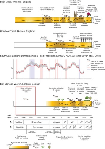
The topography and stratigraphy of our three sites, as well as our analytical results, suggest that soil retention was facilitated in different ways (Figure 8). The gentle topography, laterally extensive cultivation stratigraphy, and lack of hiatuses or inversions suggest that our two English sites were created by ploughing from the Bronze Age onwards. As there is no evidence of cutting into the hillslope to redistribute soil, these are not cut-and-fill systems and so are most likely to have been created solely by ploughing and the tillage-induced redistribution of loessic soil. In contrast, the topography, variable tread soil thickness, and pIRSL:pOSL scatter in the fills of the Sint Martens-Voeren site all suggest that the upper loess and the underlying chalk, were cut into, and loess, chalk, and soil redistributed across the tread surfaces. This is an accentuation of the natural structure in the chalk, which is sub-horizontally bedded and of variable resistance (Nyssen et al., Reference Nyssen, Debever, Poesen and Deckers2014: 169–70). It would therefore be more correct to regard the Sint Martens-Voeren lynchets as a terrace system with unwalled risers. On morphological grounds, the Belgian example resembles other steep and sharply defined systems such as the classic Mere lynchets on the scarps of Salisbury Plain and the Jurassic scarps of the Cotswold hills and Somerset in England (Whittington, Reference Whittington1962: 117–18).
Comparative site chronology and process model for the three case studies. For definitions of historical and archaeological periods, see Supplementary Material S11.

All three sites reveal multiple phases of re-creation and use. The initial creation of the lynchet at Blick Mead can be seen in the context of Middle Bronze Age activity in the Stonehenge area that included the construction of multiple round barrows and the establishment of field systems (Richards, Reference Richards1990; Roberts et al., Reference Roberts, Last, Linford, Bedford, Bishop and Dobie2017: 121–23). This is consistent with the construction of terraces in the Cheviot Hills in northern England during this period (Brown et al., Reference Brown, Fallu, Cucchiaro, Alonso, Albert and Walsh2023: 356). The Middle to Late Bronze Age start date for the Charlton Forest lynchets possibly reflects the deforestation of the South Downs during this period, as reflected by contemporaneous burnt mounds (Yates, Reference Yates2007; Yates & Bradley, Reference Yates and Bradley2010: 53–61), and aligns with lynchet formation and land use at West Dean, close to Charlton Forest (Sillar et al., Reference Sillar, Sommer and Davis2008: 54–57). Later Iron Age acceleration of agrarian practice and lynchet construction, including around hillforts, probably reflects population growth, as reflected by the construction of hillforts and proto-urban centres (oppida) prior to the Roman invasion (Bradley, Reference Bradley1971; Bowden, Reference Bowden2016), and the export of surplus grain from southern England to mainland Europe. Increased agricultural activity across the lynchets in the Roman period is likely to reflect the continuation of this system alongside the development of a new, enhanced domestic market.
The proposed Late Iron Age inception date for the Sint Martens-Voeren lynchets may be seen in the context of a population increase and agricultural land use in line with the development of the La Tène culture (Meylemans et al., Reference Meylemans, Creemers, De Bie and Paesen2015: 210); colluviation appears to have started earlier (in the Late Bronze Age) across the hilltop landscape and so the Sint Martens-Voeren sequence is in many ways comparable to that at Charlton Forest.
The varied use of the lynchet systems into the early medieval period reflects more localized agricultural conditions in both the countryside and proto-urban centres across northern Europe. Abandonment appears to happen at different times: the agricultural land at Blick Mead became a pasture for the redeveloped Amesbury Abbey after ad 1177 (Norton, Reference Norton2014), whilst Charlton Forest appears to have been abandoned in the Late Romano-British or early medieval period, before becoming part of the hunting forest of the Earls of Arundel and afforestation in the late thirteenth century ad (Roberts, Reference Roberts2018: 147–48).
By contrast, the Sint Martens-Voeren lynchets remained in use for horticulture until the eighteenth century ad, when they were converted to improved grazing land. Although hedgerow dating is not a precise technique, the high number of woody species growing today on the risers (over 9–10 woody species per 30 m) at Sint Martens-Voeren probably reflects a possible change to arboriculture c. 1000 years ago (Pollard et al., Reference Pollard, Hooper and Moore1974). At Habsheim (Alsace, France), hedges defined along reference topographic sequences provided a history of erosion across the loess-dominated landscape (Froehlicher et al., Reference Froehlicher, Schwartz, Ertlen and Trautmann2016: 173–85). Similarly, distinctive farm and woodland boundaries have been identified at specific contour levels across large areas of western and central Europe (Szabó, Reference Szabó2010: 208–09). Sunken lanes, roads, and hollow-ways have also been used to analyse the distribution and transfer of agricultural soils in relation to loess landscapes (Deckers et al., Reference Deckers, Kerselaers, Gulinck, Muys and Hermy2005: 20–29; Bell et al., Reference Bell, Black, Maslin and Toms2020: 1–8). These have been conducted in relation to topographic variation (De Geeter et al., Reference De Geeter, Poesen and Vanmaercke2020: 4), hydrology (Boardman, Reference Boardman2013: 1641–42), and within historically forested landscapes (Vanwalleghem et al., Reference Vanwalleghem, Bork, Poesen, Dotterweich, Schmidtchen and Deckers2003: 18–24; Deckers et al., Reference Deckers, Kerselaers, Gulinck, Muys and Hermy2005: 25–28). Sint Martens-Voeren also shows local variation: the lynchets on the northern slope of the valley, 2 km away, were created by ploughing and, based on estimates of tillage erosion rates, an initial construction of the lynchets is estimated to have taken place in the Gallo-Roman to medieval periods (Nyssen et al., Reference Nyssen, Debever, Poesen and Deckers2014: 172–73).
Conclusions
Loessic landscapes provide ideal agronomic conditions and facilitate the landscape-scale creation of agricultural (and in some cases co-axial) lynchet systems. The English sites presented here were first created in the Middle to Late Bronze Age by ploughing, and their formation was accelerated in the Iron Age and Romano-British periods. In the early medieval period, exploitation became more intermittent, with the Blick Mead site continuing to be used later than Charlton Forest. In contrast, lynchets at Sint Martens-Voeren were created by excavation (cut-and-fill) from the Iron Age onwards, following extensive cultivation and colluviation across the hilltop area from the Early Bronze Age, and used into the medieval and later historic periods.
Although they had previously been regarded as typical medieval lynchet sites, all three of our case studies show origins in prehistory with increased use in the Iron Age and Roman periods. The preservation of form and soil depth over several millennia indicates considerable resilience to soil erosion, which on these lithologies is known to be high under arable agriculture (Evans et al., Reference Evans, Collins, Zhang, Foster, Boardman and Sint2017: 54–56; Boardman et al., Reference Boardman, Burt and Foster2020: 3931–33). Loess played an important role in this because it facilitated easy and landscape-scale lynchet creation and rapid soil thickening, fertility being maintained by organic inputs from crops and animals. The presence and survival of these lynchets in the present-day landscape reflects the low rates of soil loss on these features compared to surrounding areas with thin soils directly on chalk and a lack of post-medieval deep ploughing. This implies that lynchets had, and still have, the capacity to confer agricultural resilience if maintained and used appropriately. It is also likely that their destruction, or indeed re-cultivation, would produce increased erosion and sediment input into fluvial systems with resultant silting up and reductions in flood discharge capacities. Whilst we have been successful in establishing the date of inception of our three lynchet systems and traced their use history, several less tractable questions remain, including the relative intensity vs frequency of their use, crop variation in the past and, even more elusively, whether their creation was driven by ‘bottom up’ customs and practices, or ‘top-down’ regional-scale command economies.
Acknowledgements
This work was undertaken as part of the European Research Council (ERC) Advanced Grant funded ‘TerrACE’ project (https://www.terrace.no/; ERC-2017-ADG: 787790, 2019–2023). The authors would like to thank the landowners and associates at Blick Mead including Sir Edward and Lady Antrobus, David Cornelius-Reid and family, and the Amesbury Museum and Heritage Trust. At Charlton Forest, sincere thanks go to His Grace the Duke of Norfolk and the Arundel Estate. The authors are also indebted to Dr Barbara Mauz (University of Salzburg, Austria) for additional assistance with OSL dating and analysis.
Supplementary Material
To view supplementary material for this article. please visit https://doi.org/10.1017/eaa.2024.6.


 Open access