Project aims
The Prehistoric Canoeists' Passages Project (PreCaPas; http://pasosdecanoeros.wordpress.com) is based on the application of geo-computing techniques (Geographical Information Systems, satellite image processing, terrain model reclassification) to characterise a significant aspect of hunter-gatherer life in the Fuego-Patagonia region of Chile; specifically, it concerns the mobility of the Kawésqar people during the period following European contact in the seventeenth century.
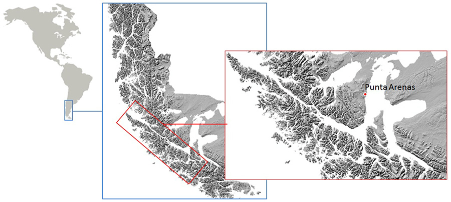
Location map of study area.

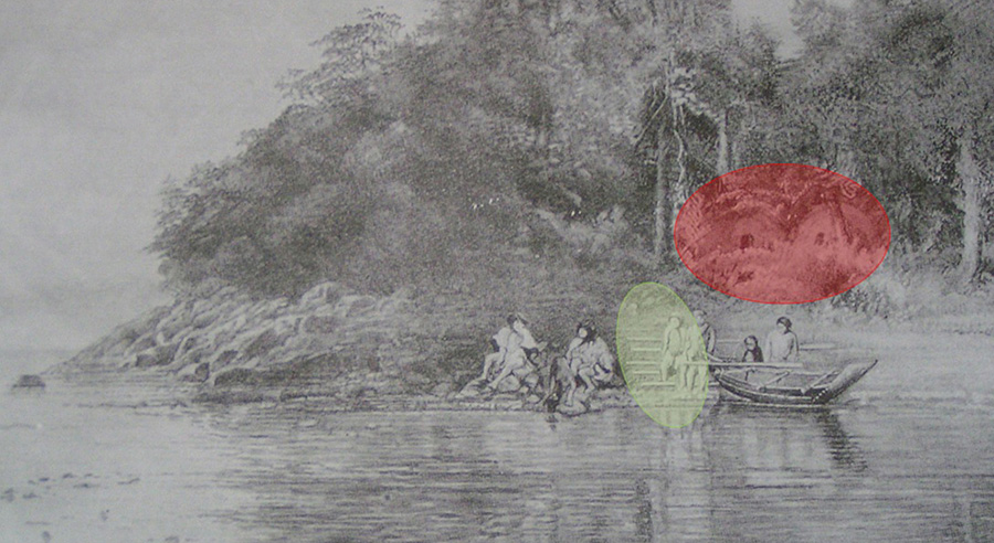
Early-twentieth-century drawing illustrating a passage, with horizontal poles (in green), up which canoes were carried, with huts in close proximity (in red) (Reference RoutledgerRoutledger 1919: 86).

The Kawésqar territory in this southern part of South America was first inhabited 6500 years ago; by the end of the nineteenth century, however, extensive contact with Europeans had almost wiped out the local population—respiratory disease being the most likely cause. The Kawésqar were hunter-gatherers who focused on the exploitation of littoral resources through continuous transhumance by coastal navigation (Reference EmperaireEmperaire 1963; Braum 1974; Bailey & Parkington 1988). Groups travelled by canoe (up to 8 or 9m in length and 1m in width) around the fragmented Patagonian coast, in the area between the Gulf of Penas (47°15'0" S, 75°0'0" W) to the north and the Brecknock Peninsula (54°34'60" S, 71°49'60" W) to the south. Each canoe could transport a family of up to nine persons.
The only source of information about these 'sea nomads'—a term first coined by J. Reference EmperaireEmperaire (1963)—comes from ethnographical records, which include information about a peculiar practice: crossing over land bridges to other coastal regions. These 'passages' were more than simply routes to shorten the distances involved in coastal navigation or to avoid certain obstacles (e.g. dense forest, glaciers, social boundaries, etc.). They should be understood as an amalgam of natural landscape features and social factors which enabled different solutions to Kawésqar needs.
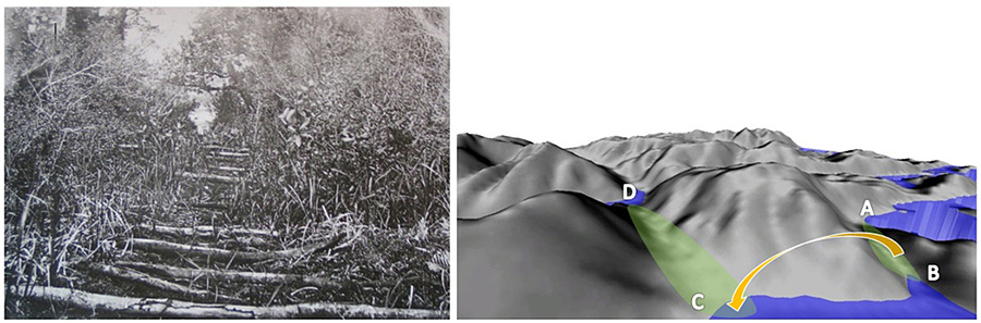
Hypothetical examples. Left: horizontal pole structure (generic example from McEwan et al. 1997: 68). Right: DEM simulation of possible passage route.

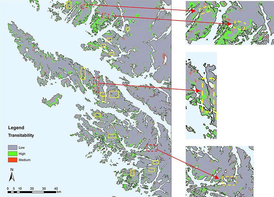
Modelling potential passages. Potential examples (in yellow boxes) with close-ups of the four cases where archaeological fieldwork is planned. Picture elaborated for E. Cerrillo and J. Martinez, IAM-CSIC Mérida, Spain (from Maximiano Castillejo et al. 2013).

The main aim of PreCaPas is the quantitative characterisation of these ethnographically-attested routes, or passages, and to make spatial predictions of potential passages within the study area. The project aims to solve a problem of archaeological visibility: how to recognise and find possible routes associated with these passages. To answer this question, the project team has adopted archaeological spatial prediction as our basic methodology (Fry et al. 2004; Mehrer & Wescott 2006; Verhagen & Whitley 2012).
Archaeological problems
The passage system used by the Kawésqar canoeists was not only an expedient solution for shortening transport routes, but also structured the palaeo-landscape and facilitated intra-group and inter-ethnic interaction (e.g. access to exogenous raw materials, exchange of individuals and prestige goods, spread of ideas and knowledge, etc.). It is very likely that this system would have played a significant role in communication and exchange networks among different social collectives. But this system is very difficult to detect and interpret archaeologically due to, firstly, the issue of exactly what constitutes a passage, and secondly, and perhaps more importantly, issues hampering archaeological detection (e.g. dense vegetation cover, low visibility of associated structures, etc).
First outcomes: potential locations of particular passages
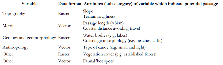
From ethnographic sources, the Kawésqar people had many different types of passage and various ways of using them. The PreCaPas project works with a particular type: those less than 8km in length. There are four ethnographically attested examples: Churruca, Skyring, Hoste and Xaltegua (Reference RoutledgerRoutledger 1919; Prieto Iglesias et al. 2000). From these four known passages, the project team has identified key variables with which we aim to predict the location of other examples. The variables include: topography (slope and terrain roughness), distance (passage length versus coastal distance), geomorphology (presence of water bodies on passage route, topography of sea/land transition points), type of canoe, potential presence of structures (e.g. horizontal poles, associated huts), vegetation cover, sea currents and access to hunting grounds.
The study area is located between the western entrance of the Strait of Magellan (Desolation Island) and its eastern limit at Dawson Island. The goal is to detect specific passages (<8km, across fairly flat transit areas). The spatial predictive methodology uses a GIS platform (both vector and raster data), combining variables and reclassifying the landscape to indicate locations of high, medium or low probability of the presence of a passage.

Using the input variables, the model identified 18 locations with high probability of the presence of a passage. The effectiveness of the model was evaluated through comparison with control points (both positive and negative potential passages) and the team considers the model to have performed well at this spatial resolution because, in our test series, the control points were correctly identified.
The future
Following the initial analysis, the project team is designing a more complex algorithm to facilitate an automatic and exhaustive method to detect potential passages of different types in the Kawésqar landscape. We are also planning archaeological fieldwork to ground-truth the results of the modelling. In the future, we are also interested in applying this methodology in other regions with similar ecological and geographical situations; for example, potentially this approach could be used to address specific problems about mobility during the Mesolithic period along the Scottish (Hardy & Wickham-Jones 2009) and Norwegian coastlines (Glørstad 2013).