

Climate change drives multiple processes that threaten the world's archaeological sites (Andrews and MacKay Reference Andrews and MacKay2012; Chapman Reference Chapman2002; Colette et al. Reference Colette, Bomhard, Byers, Cassar, Castellanos, Dourojeani, Elloumi, Han, Hoegh-Guldberg, Khawlie, Mcleod, Merson, Midgley, Mous, Olynyk, Sidi, DSalm, Sherpa and Young2007; Howard Reference Howard2013). The recent marked increases in global average temperature and sea level are predicted to continue, along with increasingly frequent extreme weather events (IPCC 2013). The Arctic has already experienced some of the most rapid climate change in the world (Lemmen et al. Reference Lemmen, Warren, James and Mercer Clarke2016) and continues to be particularly impacted through a combination of increased sea and air temperatures, sea ice reduction, a longer open-water season, ice sheet melt, and the warming and thaw of permafrost (IPCC 2013).
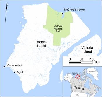
Coastal erosion, accelerated by permafrost thaw, wave action, and increased storm surges, means that entire Arctic sites are being lost to the sea. The Beaufort Sea coast (Figure 1 inset) is among the hardest hit, with some regions seeing mean coastal erosion rates of over 6 m per year (Jones et al. Reference Jones, Hinkel, Arp and Eisner2008). In addition, some of the area's coastal sites are being inundated. The nineteenth-century whaling site on Herschel Island, which is under consideration for nomination to the UNESCO World Heritage List, is perhaps the best known. In an attempt to preserve them, some of the site's whaling structures have already been moved inland (Colette et al. Reference Colette, Bomhard, Byers, Cassar, Castellanos, Dourojeani, Elloumi, Han, Hoegh-Guldberg, Khawlie, Mcleod, Merson, Midgley, Mous, Olynyk, Sidi, DSalm, Sherpa and Young2007).
Banks Island, showing location of sites mentioned in the text.
Other threats to the Arctic archaeological record include the severe degradation of near-surface permafrost, which projections suggest will decrease by 37–81 percent by the end of the twenty-first century (Collins et al. Reference Collins, Knutti, Arblaster, Dufresne, Fichefet, Friedlingstein, Gao, Gutowski, Johns, Krinner, Shongwe, Tebaldi, Weaver, Wehner, Stocker, Qin, Plattner, Tignor, Allen, Boschung, Nauels, Xia, Bex and Midgley2013; IPCC 2013). The cold Arctic climate has long meant remarkable organic preservation on Arctic archaeological sites. This rich material record sheds light on past cultural developments and also includes numerous paleoenvironmental proxies (plant and animal remains) that can be used to reconstruct long-term climate records and to examine food webs, population dynamics, and the evolutionary history of these species (Jensen et al. Reference Jensen, Fitzhugh, Hambrecht, Dawson, Dugmore, Harrison and McGovern2015). The thawing permafrost and associated increase in the depth of the active layer will see marked deterioration of organic artifacts and environmental remains that have been preserved in the permafrost, in some cases for millennia (Blankholm Reference Blankholm2009; Hald Reference Hald2009; Jensen et al. Reference Jensen, Fitzhugh, Hambrecht, Dawson, Dugmore, Harrison and McGovern2015). Permafrost thaw can also lead to the subsidence of level surfaces and cause slides, flows, and thaw slumps on slopes (Nelson et al. Reference Nelson, Anisimov and Shiklomanov2001), disturbing the stratigraphic integrity of neighboring sites. The seasonal thawing and freezing of the active upper layer of permafrost results in cryoturbation, which moves soils (and the artifacts they contain) both vertically and horizontally (French Reference French2007; Williams and Smith Reference Williams and Smith1989). This process is already impacting graveyards on Herschel Island, breaking caskets and pushing them out of the ground (Colette et al. Reference Colette, Bomhard, Byers, Cassar, Castellanos, Dourojeani, Elloumi, Han, Hoegh-Guldberg, Khawlie, Mcleod, Merson, Midgley, Mous, Olynyk, Sidi, DSalm, Sherpa and Young2007).
In the face of these threats to the Arctic archaeological record, archaeologists, heritage managers, and northern communities are scrambling to document threatened sites. Given the size of the region and the high cost of accessing its archaeological sites, we need to develop strategies for monitoring sites, assessing the level of threat, and prioritizing them for further investigation. Several ongoing research projects in the western North American Arctic have begun to do so (Anderson Reference Anderson2014; Friesen Reference Friesen2015; Jensen et al. Reference Jensen, Fitzhugh, Hambrecht, Dawson, Dugmore, Harrison and McGovern2015). Meeting these challenges requires the application of a range of methods to rapidly gather data about site structure and to monitor changes to sites that are not under immediate threat. Satellite imagery, lidar, drones, 3D scanning, and geophysical techniques can, among other things, be used productively to these ends. Important work using 3D scanning to digitally document threatened sites has already been done (Dawson et al. Reference Dawson, Bertulli, Levy, Tucker, Dick and Cousins2013). Here, we focus on the potential role of magnetometer survey in managing Arctic sites in the face of climate change. Using a series of case studies from Banks Island, located on the eastern edge of the Beaufort Sea, we show how magnetometer survey can be used to rapidly locate buried features and gather data about site structure, including differentiating between dwelling types. These data can either stand alone or be used to strategically target areas for excavation. We also demonstrate magnetometry's utility in establishing how sites are likely to respond to coastal erosion, thereby identifying areas that are most at risk.
Archaeological Geophysics and the Arctic Environment
Geophysical survey techniques have become an indispensable tool in the nonintrusive identification and mapping of archaeological sites and landscapes in many parts of the world (Clark Reference Clark1990; Johnson Reference Johnson and Johnson2006; Scollar et al. Reference Scollar, Tabbagh, Hesse and Herzog1990). However, while near-surface geophysical techniques are used in a variety of Arctic applications, including the study of permafrost (Kneisel et al. Reference Kneisel, Hauck, Fortier and Moorman2008; Wu et al. Reference Wu, Wang, Watanabe, Chen and Battogtokh2009), paleoclimate (Begét Reference Begét1996; Vandenberghe et al. Reference Vandenberghe, Lu, Sun, van Huissteden and Konert2004), and depositional and erosional processes (Nesje et al. Reference Nesje, Matthews, Dahl, Berrisford and Andersson2001; Zhu et al. Reference Zhu, Matasova, Kazansky, Zykina and Sun2003), they are rarely employed in the investigation of archaeological sites. Their potential in this context is illustrated by their use to identify buried historic iron artifacts (Arnold Reference Arnold1982; Gibson Reference Gibson1982), locate buried dwellings, burials, middens, and burnt features, including hearths (Eastaugh and Taylor Reference Eastaugh and Taylor2005, Reference Eastaugh, Taylor and Renouf2011; Stamnes and Gustavsen Reference Stamnes, Gustavsen, Kamermans, Godja and Posluschny2014; Viberg et al. Reference Viberg, Trinks and Lidén2009; Viberg et al. Reference Viberg, Berntsson and Liden2013), identify buried stone features, including tent rings (Landry et al. Reference Landry, Ferguson, Milne and Park2015), and distinguish anthropogenic features from naturally occurring permafrost and geological features (Hodgetts et al. Reference Hodgetts, Dawson and Eastaugh2011; Wolff and Urban Reference Wolff and Urban2013).
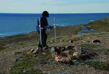
Magnetometry, due to its ability to detect a broad range of archaeological features, high spatial resolution, and rapid data acquisition, has become one of the most widely used geophysical techniques in archaeology (Kvamme Reference Kvamme and Johnson2006) and holds particular potential for archaeological survey in northern regions. Capable of surveying up to 1 ha a day at sampling densities of 60 measurements per m2, magnetometry is able to investigate large areas quickly and resolve the small, ephemeral features commonly encountered on hunter-gatherer sites (Hodgetts et al. Reference Hodgetts, Dawson and Eastaugh2011; Kvamme Reference Kvamme2003). Both are critical factors in Arctic archaeology, since the brief snow-free season and remote location mean that field seasons are short and expensive. Magnetometry also has advantages over techniques such as GPR and earth resistance survey because operators carry the instruments above the ground during data collection (Figure 2). Arctic sites often contain stone-built surface features, including tent rings, caches, hearths, and kayak rests, which impede instruments that must remain in contact with the ground surface.
Magnetometer survey (Bartington Grad 601 Dual Sensor Fluxgate Gradiometer) on Banks Island showing rock features common on the surface of Arctic sites. Note opened meat cache in the foreground.
A further strength of magnetometer survey is its ability to identify a range of non-anthropogenic features. While geophysical anomalies caused by natural features often make it more difficult to identify those of archaeological origin, geophysical mapping of permafrost features can be valuable in predicting climate change impacts on Arctic archaeological sites. Frost action can create vertical ice wedges that penetrate many meters underground (Murton Reference Murton and Elias2007). While ice wedges often produce linear depressions on the ground surface, these surface features do not always reflect the full extent of the subsurface ice. Magnetometer survey can be used to map these buried ice features (Hodgetts et al. Reference Hodgetts, Dawson and Eastaugh2011). This information can assist archaeologists in assessing the level of threat to coastal sites, since ice wedges create mechanical weaknesses along which eroding coasts can fracture (Gunther et al. Reference Gunther, Overduin, Sandakov, Grosse and Grigoriev2013). It can also help archaeologists to monitor temporal changes in ice wedge extent as part of longer-term monitoring strategies and to target areas for further investigation that are either the least disturbed or the most threatened by ice wedges, depending on their aims.
Although magnetometer survey holds significant potential for Arctic archaeology, the periglacial environment presents challenges in its application. The success of any magnetometer survey depends on a number of factors, in particular the presence of measurable differences in the magnetic susceptibilities (the ability of a material to become magnetized) of the soils and features being investigated (Kvamme Reference Kvamme and Johnson2006). Topsoil typically becomes magnetically enhanced compared to the subsoil during soil development (Dalan Reference Dalan2008; Dearing et al. Reference Dearing, Hay, Baban, Huddleston, Wellington and Loveland1996; Maher and Taylor Reference Maher and Taylor1988). Human activities also magnetically enhance the iron minerals in soils, primarily through burning (Le Borgne Reference Le Borgne1955; Reference Le Borgne1960; Tite and Mullins Reference Tite and Mullins1971). Burnt features and features containing burnt material (e.g., hearths, fire-cracked rock, middens) are common on archeological sites and carry a thermoremanent magnetism, making them identifiable as characteristic dipole anomalies, defined as “two equal magnetic poles of opposite sign separated by a very short distance” (Clark Reference Clark1990:169). Occupation deposits and middens are also identifiable due to bacteria-induced magnetic enhancement of organic refuse during decomposition (Faßbinder and Stanjik Reference Faßbinder and Stanjek1993). However, in regions with limited topsoil development, such as the high Arctic, magnetometer survey can be less effective because of limited magnetic contrast between archaeological features and the surrounding subsoil (Kvamme Reference Kvamme and Johnson2006). Another potential impediment for Arctic magnetic survey is the region's glacial till deposits composed of gravel and boulders of varying geological composition. The magnetic properties of igneous rocks, and their jumbled arrangement within the till, can produce magnetic signals that either are indistinguishable from or “drown out” those of archaeological interest (Clark Reference Clark1990; Hodgetts et al. Reference Hodgetts, Dawson and Eastaugh2011; Horsley and Dockrill Reference Horsley and Dockrill2002).
Proximity to the magnetic pole also has an effect on the results of Arctic geophysical survey. Both the strength and inclination of the earth's magnetic field change with geomagnetic latitude (proximity to the magnetic pole), with typical strengths ranging from 30,000 nT at the equator to 60,000 nT at the poles, and the inclination of the magnetic field ranging from horizontal at the equator to vertical at the poles (Kvamme Reference Kvamme and Johnson2006; Tite Reference Tite1972). As the measured field is the vector sum of the earth's magnetic field and the field created by a local feature, the shape of the resulting anomaly depends on the geomagnetic latitude of the survey (Tite Reference Tite1972).
In the mid-northern latitudes, where angle of inclination usually ranges between 55 and 75 degrees (Kvamme Reference Kvamme and Johnson2006), a normal dipole anomaly resulting from a feature with induced magnetism, such as a refuse-filled pit, will be slightly offset from the feature itself. When measured with a fluxgate gradiometer, the most commonly used magnetometer for archaeological applications, the anomaly is characterized by a profile with a maximum positive peak south of the source by approximately one-third the source to sensor distance, and a negative trough to the north of the source (Schmidt Reference Schmidt, Gubbins and Herrero-Bervera2007; Tite Reference Tite1972). As geomagnetic latitude increases, the maximum positive peak measured by a fluxgate gradiometer becomes stronger and shifts northward relative to the source, becoming centered directly over the source at the magnetic pole, while at the same time the corresponding negative trough diminishes in strength (Clark Reference Clark1990; Weymouth Reference Weymouth1986). Thus, at the magnetic pole, when results are presented as a magnetic map (as in the case studies below), a dipole anomaly resulting from induced magnetization would show a central high ringed by a low, while at mid-northern continental latitudes it would show a high adjacent to a low, aligned to the magnetic pole (Kvamme Reference Kvamme and Johnson2006). Objects with remanent magnetism, such as iron items and igneous rocks, produce anomalies referred to as non-normal dipoles. They show a more pronounced negative trough than normal dipoles (Weymouth Reference Weymouth1986). While they generally show as a high adjacent to a low, the orientation of the dipolar alignment depends on the orientation of the objects themselves (Kvamme Reference Kvamme and Johnson2006). However, because the angle of inclination is vertical (90°) at the magnetic pole, an anomaly resulting from in situ thermoremanent magnetism at the magnetic north pole would show a central high ringed by a low, similar to anomalies produced by features with induced magnetism.
Despite these challenges, the potential of Arctic magnetometry is supported by the results of geophysical surveys from a variety of northern regions, including Alaska (Wolff and Urban Reference Wolff and Urban2013), Arctic and Subarctic Canada (Eastaugh and Taylor Reference Eastaugh and Taylor2005, Reference Eastaugh, Taylor and Renouf2011; Hodgetts et al. Reference Hodgetts, Dawson and Eastaugh2011; Landry et al. Reference Landry, Ferguson, Milne and Park2015), and northern Europe (Horsley and Dockrill Reference Horsley and Dockrill2002; Stamnes and Gustavsen Reference Stamnes, Gustavsen, Kamermans, Godja and Posluschny2014; Viberg et al. Reference Viberg, Trinks and Lidén2009; Viberg et al. Reference Viberg, Berntsson and Liden2013). These studies suggest that magnetometer survey can successfully document the archaeological features of interest on sites created by Arctic hunter-gatherers. Other geophysical techniques, including ground-penetrating radar and electromagnetic survey, have been less successful at resolving archaeological features, although they provide valuable information on the underlying geology, stratigraphy, and geomorphology (Meulendyk et al. Reference Meulendyk, Moorman, Andrews and MacKay2012; Wolff and Urban Reference Wolff and Urban2013).
Case Studies
Three case studies illustrate the benefits of magnetometer survey for archaeologists and cultural resource managers working in the Arctic. The sites in question, McClure's Cache, Cape Kellett, and Agvik, are located on Banks Island, Northwest Territories (Figure 1), and were surveyed between 2010 and 2014. Banks Island sits on the eastern edge of the Beaufort Sea, and while its coasts are not the worst affected by erosion in the region, they are under considerable threat (Lantuit et al. Reference Lantuit, Overduin, Couture, Wetterich, Aré, Atkinson, Brown, Cherkashov, Drozdov, Forbes, Graves-Gaylord, Grigoriev, Hubberton, Jordan, Jorgensen, Ødegård, Ogorodov, Pollard, Rachold, Sedenko, Solomon, Steenhuisen, Streletskaya and Vasiliev2010; Lemmen et al. Reference Lemmen, Warren, James and Mercer Clarke2016). Geologically, the Banks Island Coastal Plain, which runs along the island's west coast, is underlain by unconsolidated Tertiary or early Pleistocene sands and gravel and is characterized by low rolling hills. To the east, the remainder of the island forms the Banks Island Lowland ecoregion. It consists largely of late Proterozoic stratified rocks (sandstone, siltstone, and shale), with gabbro sill intrusions (Ecological Stratification Working Group 1995). Surface deposits have been extensively reworked by fluvial, glacial, and marine processes. Permafrost is deep and continuous across the island and is characterized by high ice content and frequent ice wedges. The island ranges in latitude from 72 to 74 degrees north and has an inclination of 84 degrees at Sachs Harbour on its south coast. The shape of magnetic dipole anomalies resulting from induced magnetism will therefore be intermediate between those seen at mid-northern latitudes (magnetic high adjacent to magnetic low) and those expected at the magnetic pole (magnetic high surrounded by a magnetic low).
We conducted two surveys (Cape Kellett and Agvik) with a Bartington Grad 601 Dual Sensor Fluxgate Gradiometer, and one (McClure's Cache) with a Geoscan FM256 Fluxgate Gradiometer. The surveys utilized grids of 20 m by 20 m, and logged readings at 0.125 m intervals along parallel traverses spaced 0.25 m apart. The only exception was McClure's Cache, where we used a larger traverse interval of 0.50 m. We downloaded the raw data from the magnetometer surveys into Geoplot 3.00t for processing and conversion into grayscale images. The presented results are clipped to ±3 nT to strengthen the contrast of archaeological features relative to the strong magnetic responses resulting from igneous erratics and iron objects on all three sites.
McClure's Cache (QaPv-1)
McClure's Cache (Figure 1) is a deposit of goods left in 1853 on the coast of Mercy Bay, on Banks Island's north coast, by Captain Robert McClure and the crew of HMS Investigator during their failed attempt to locate Sir John Franklin and his men. The cache was comprised of their unused supplies, including casks of salt meat and dry goods, clothing, six small boats, muskets, ammunition, and a supply of coal.
Our magnetometer survey of the site was part of the HMS Investigator Rediscovery Project (Cohen Reference Cohen2013), launched by Parks Canada Agency in 2010, which sought to locate the ship in Mercy Bay and record evidence of the crew's land-based activities around McClure's Cache. The principal aim of the magnetometer survey was to locate the unmarked graves of three British sailors who perished during the expedition and were buried in 1852. Historic accounts (Armstrong Reference Armstrong1857; Neatby Reference Neatby1967; Nelson Reference Nelson1967; Osborn Reference Osborn1969) described the graves on the shore near the ship, but previous pedestrian surveys had failed to locate them. The Mercy Bay coast, like many parts of Banks Island, is seeing increasing subsidence and retrogressive thaw slumping due to thawing permafrost (Segal et al. Reference Segal, Lantz and Kokelj2016). Figure 3 shows a large thaw slump that opened up adjacent to the McClure's Cache site during the 2010 field season. It was important to locate the graves to assess their risk of damage as a result of such processes.
Thaw slump due to melting permafrost at McClure's Cache (QaPv-1).

The survey area encompassed the coal deposit, the adjacent concentration of broken barrels, and a large area of gently sloping ground to their north (Figure 4). The magnetometer survey took less than a day to locate the graves, which took the form of three positive lozenge-shaped anomalies, approximately 50 m north of the main cache (Figure 4a). Inspection of the ground surface confirmed the anomalies as graves, with the cuts still visible, and in one case a low mound of earth marked the feature. A single round positive anomaly east of the central grave (Figure 4b) was likely associated with the grave marker mentioned in the journal of Johann Miertsching (Neatby Reference Neatby1967), the Moravian missionary who served as the ship's Inuktitut translator. Likewise, two backfilled, 1 m2 test pits, likely from Clifford Hickey's unpublished excavations in the 1980s, also presented as large positive anomalies (Figure 4c). As expected, the survey also identified many dipolar anomalies of varying orientation, which correspond with iron artifacts, including barrel hoops and tin can fragments, lying on the site surface (Figure 4).
Results from McClure's Cache (QaPv-1) survey area showing the dense concentration of dipolar anomalies associated with the cache site: (a) graves, (b) grave marker, and (c) unmapped 1980s test units.

Cape Kellett (OlRr-1)
Cape Kellett is the earliest known Thule Inuit site on Banks Island, and one of the earliest in Arctic Canada (Figure 1), with two phases of occupation around cal A.D. 1200 and 1350. The site was first recorded by T. H. Manning in 1952 and consists of an alignment of nine winter houses along a gravel beach. The remains of Manning's wooden shack and a relatively recent tent ring are also visible at the site (Figure 5). While the full extent of Manning's (Reference Manning1956a, Reference Manning1956b) excavation is unknown, our fieldwork identified three partially excavated dwellings (Figure 5:H6, H8, and H9) and three others (Figure 5:H3, H4, H5) that show evidence of disturbance related to his work, to looting, or to erosion. The two westernmost houses (H1 and H2) have been largely destroyed by erosion. Three large ice wedges, visible as linear surface depressions, also cut through the site.
Results of the magnetometer survey at Cape Kellett (OlRr-1), showing numerous small dipolar anomalies and subsurface ice features.

We hoped Cape Kellett would provide the opportunity to investigate the effects of permafrost action and previous excavation on the magnetometer data and allow us to explore the potential of magnetometry in documenting the full extent of ice wedges at the site as well as the internal structure of Thule winter houses. The survey area was positioned over seven of the dwellings, including House 6 excavated by Manning and the three disturbed structures, and also encompassed surface evidence of ice wedges and Manning's shack (Figure 5).
Unfortunately, the results of the Cape Kellett survey are less clear than those obtained from McClure's Cache, due to numerous small, round positive and dipolar anomalies of varying magnetic intensity distributed across the site (Figure 5). Many of the stronger dipolar anomalies were identified as iron objects lying on the beach surface (Figure 5a). They are particularly dense in the vicinity of Manning's collapsed shack where iron nails and other fixings litter the ground surface (Figure 5b). However, ground truthing at the site revealed that many of the anomalies result from igneous cobbles deposited within the substrate. The magnetic response of these cobbles varies considerably from 0 nT, for cobbles of sedimentary origin, to beyond the range of the instrument (100 nT) for igneous cobbles, depending on their size, orientation (which determines the shape of the anomaly), depth below surface, and geological composition (both influencing the strength of the anomaly). Similar anomalies have been attributed to igneous rocks on other Arctic sites (Hodgetts et al. Reference Hodgetts, Dawson and Eastaugh2011; Hodgetts et al. Reference Hodgetts, Eastaugh and Munizzi2015). They represent one of the greatest impediments to Arctic magnetometer survey, as their magnetic responses are often indistinguishable from other sources of remanent magnetism of archaeological interest, such as iron objects. Additionally, when present in large numbers they “drown out” the subtler responses associated with archaeological features and impede their identification. This “noise” made it difficult to differentiate between intact and disturbed house features at the site. The Cape Kellett case study highlights the limitations of magnetometry in interpreting archaeological site structure in Arctic settings with large numbers of glacially deposited igneous cobbles.
Despite these limitations, our survey identified dipolar anomalies caused by the ice wedges (Figure 5). These anomalies extend beyond the visible surface traces, indicating that the buried ice wedges are larger than they appear on the surface. It also identified another ice wedge with no surface trace, running through House 4 (Figure 5d; Figure 6). The boundary between the tundra vegetation and the exposed gravel beach is also visible as a diffuse linear positive anomaly (Figure 5e). House 5 was the only one of the seven surveyed houses that was clearly identifiable in the results. The structure presents as a weak sub-circular positive anomaly surrounding a weak negative center (Figure 6).
Detail of magnetometer results at Cape Kellett (OlRr-1) showing the differences between House 4, where a substantial ice wedge obscures the structure, and House 5, where the structure is clearly visible.

Agvik (OkRn-1)
Agvik (OkRn-1) is a Thule Inuit site (ca. cal A.D. 1350–1550) located approximately 50 km southeast along the coast from Cape Kellett on a high bluff overlooking Amundsen Gulf (Figure 1). It includes the remains of 14 dwellings, 11 of which cluster near a gully (Figure 7), and a further three of which are located between 100 and 200 m to the northeast. They are visible as round depressions ringed by low mounds. The gully, which borders the western edge of the site, is eroding rapidly toward the adjacent dwellings. Comparison of the gully edge documented in 2014 to that mapped by Arnold (Reference Arnold2010) in 2009 indicates that it has eroded up to 20 m in that five-year period (Figure 7). If the erosion continues at that rate, the four dwellings immediately adjacent to the gully could disappear in the next five years. We also witnessed substantial chunks of coast (upward of 20 m in depth) falling into the sea within a few kilometers of Agvik. A similar event at the site would leave very little buffer between the active cliff face and the dwellings.
Map of Agvik (OkRn-1), showing dwelling locations, eroding gully, and magnetometer survey area.
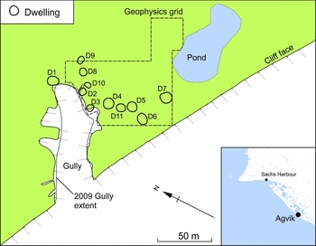
We established a survey grid covering approximately 6,400 m2 over the dwellings in the immediate vicinity of the gully and cliff face (Figure 7). Anomalies in the magnetometer data allowed us to identify numerous archaeological and natural features (Figure 8). The most obvious are those resulting from ice wedges, which show as negative, and, to a lesser extent, dipolar anomalies that crisscross the site. There is little surface evidence for some of these features, so the survey results are useful in establishing the level of threat from buried permafrost features to individual dwellings. The most prominent ice wedge is represented by the negative linear anomaly that runs southwest to northeast across the entire survey area (Figure 8a). Between 2009 and 2015, the gully erosion was greatest along the line of this ice wedge. Having a map of the subsurface ice allows us to predict the most likely direction of future erosion and which dwellings are under most imminent threat. A similar line of erosion is beginning to develop along a smaller ice wedge immediately north of Dwelling 2 (Figure 7). The cliff edge is another area of concern, since this region of the Banks Island coast is eroding rapidly. The magnetometer data indicate that an ice wedge runs parallel to the cliff (Figure 8b), forming a weak point along which the sandy coastal soils could cleave as they are weakened through permafrost thaw. The survey also identified many small, round positive anomalies located in the vicinity of the depressions (Figure 8c). The cut features from McClure's Cache, including the graves and backfilled test units, produced similar positive anomalies, indicating that these may also represent cut features such as pits.
Results of magnetometer survey at Agvik (OkRn-1), revealing the numerous subsurface ice features that crisscross the site.
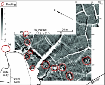
We also identified numerous anomalies associated with the dwellings. Significantly, despite the surface similarities of the dwellings, the magnetometer survey, in combination with excavation evidence, suggests that the structures represent at least two types: winter houses and qarmat (singular: qarmaq). Thule Inuit winter houses were large, oval semi-subterranean structures with a flagstone or driftwood floor; a raised rear sleeping platform of stone slabs; walls of stone and whalebone; a sod roof; and an entrance tunnel (McGhee Reference McGhee1978). Qarmat are generally defined as less substantial structures with a smaller, shallower central depression, and a skin as opposed to sod roof (Boas Reference Boas and Hope2013 [1888]; Mathiassen Reference Mathiassen1927). They were primarily occupied in the transitional seasons of spring and fall, though there are also accounts of their use through the winter (Mathiassen Reference Mathiassen1927). There was clearly considerable variability in the construction of both types of dwelling. Winter houses ranged from large, heavily built “high-cost/low-maintenance” structures to smaller, more lightly built “low-cost/high maintenance” ones (Dawson Reference Dawson2001). Qarmat varied from surface structures to semi-subterranean ones of varying depth, with or without entrance tunnels (Boas Reference Boas and Hope2013 [1888]; Park Reference Park1988). While there was doubtless overlap between the two types, individual dwellings may be more closely aligned with one or the other.
Prior to 2014, Arnold (Reference Arnold2010) and our team interpreted all of the dwellings at Agvik as winter houses. However, the excavation of Dwelling 2 revealed a collapsed sod wall around a ground-level earthen platform, which ringed a central depression. Because in most cases the entire interior of winter houses is semi-subterranean, with a raised stone or driftwood platform at the rear of the structure, we now interpret Dwelling 2 as a qarmaq (Hodgetts et al. Reference Hodgetts, Eastaugh, Haukaas and Kelvin2014). It conforms quite closely to Boas's (Reference Boas and Hope2013 [1888]:Figure 498) illustration of a qarmaq.
The anomalies associated with Dwelling 2 included a number of positive magnetic highs located in the center of the dwelling and two weak, diffuse positive magnetic highs immediately outside to the east and south (Figure 9:D2). Excavation demonstrated that these resulted from small, discrete features, including a central cooking area with large deposits of burnt material, several storage pits (filled with organic remains), and two thin external middens. While the magnetic response of some of the other dwellings is obscured because of their proximity to ice wedges (D10 and D11), several (D3, D4, and D8) display arrangements of anomalies similar to Dwelling 2. Like Dwelling 2, all of these structures are at the smaller end of the size range at the site, and none have the remains of whale-bone posts projecting from their surface. These anomalies may therefore represent other qarmaq, as we can reasonably expect weaker, less well-defined anomalies associated with structures with a smaller, shallower semi-subterranean component, and stronger, more clearly defined anomalies with those that have a larger, deeper, semi-subterranean component containing more magnetically enhanced occupation and/or midden deposits and more substantial architecture. This interpretation is supported by the magnetic responses of three of the largest structures (D5, D6, and D7), which are associated with ring-shaped positive anomalies (sometimes discontinuous) surrounding the central depression (Figure 8, Figure 9:D5 and D7). These anomalies look very similar to that from House 5 at Cape Kellett.
Detail of magnetometer survey at Agvik (OkRn-1), showing anomalies associated with three of the semi-subterranean dwelling features.

The magnetometer results from Agvik suggest two dwelling types, producing distinct magnetic anomalies resulting from varying architectural forms and/or different occupational intensity associated with different functions or seasons of occupation. Faunal remains from Dwelling 2 demonstrate that it was occupied in late winter to spring and also in fall. Those from Dwelling 5 suggest fall and winter occupation. Dwelling 1, another large dwelling, not included in the magnetometer survey, suggest a primarily winter occupation (Kotar Reference Kotar2016). The magnetometer survey, Dwelling 2 excavation, and zooarchaeological analysis together suggest that the smaller structures at Agvik represent qarmat, occupied primarily in spring and fall, and that the larger structures represent more substantial winter houses.
Discussion
These case studies demonstrate that magnetometer survey provides a means of rapidly documenting the structure of sites, locating archaeological features of interest, and differentiating between certain dwelling types, and can therefore increase the efficiency of archaeological activities on some Arctic sites as we attempt to mediate the impacts of climate change. At McClure's Cache, it rapidly located the position of the sailor's graves, a standard application of the technique, though rare in an Arctic context. The efficiency of the McClure's Cache survey will, hopefully, encourage those responsible for managing Arctic sites to consider magnetometer survey as a useful tool to help maximize field time, given the logistical challenges of Arctic research.
At Agvik, the magnetometer results suggested structural differences between the dwellings at the site. Combined with limited excavation and subsequent faunal analysis, these differences indicate seasonal movements between more substantial winter houses and less heavily built spring/fall qarmat by the site's occupants. This was the only site where our research permit allowed for excavation to ground-truth the geophysical survey results. Ground-truthing revealed that archaeological features (e.g., refuse-filled pits and external middens) with magnetic susceptibility values that contrast with those of the surrounding soil, created positive anomalies, or positive anomalies partially or completely ringed by negative ones. The latter is exactly what we would expect from a dipolar anomaly resulting from induced magnetism at this high latitude. In this case, the integration of magnetometer survey with excavation allowed us to develop a much fuller understanding of the site.
While these elements of the McClure's Cache and Agvik data are promising, other results from Cape Kellett and Agvik illustrate that the technique is not a panacea, mapping the location of archaeological features and providing information about dwelling structure in all cases. When the substrate is glacial till containing large numbers of igneous cobbles, they “wash out” anomalies associated with archaeological features in the same way as recent ferrous metal objects across a site. The strong linear negative or dipolar anomalies produced by ice wedges likewise obscure anomalies of archaeological interest.
Nonetheless, all three case studies highlight the utility of the magnetometer data in assessing the threat to the archaeological remains as a result of climate change processes. At McClure's Cache, the magnetometer survey assisted in evaluating the threat to the graves simply by determining their location. The graves are on level ground, so are not imminently threatened by thaw slump activity at the site, which occurs on sloping terrain. At Cape Kellett and Agvik, ice wedges accelerate coastal erosion. Mapping them with the magnetometer allowed us to predict the trajectory of future erosion and thereby determine which archaeological features are most imminently threatened.
Conclusion
Magnetometry is clearly useful in many Arctic contexts, for rapidly mapping both archaeological and permafrost features. Research in other regions has repeatedly shown that, because different geophysical techniques are better at identifying different types of cultural and natural features, they are most effective when used in concert (e.g., Keay et al. Reference Keay, Earl, Hay, Kay, Ogden and Strutt2009; Kvamme et al. Reference Kvamme, Johnson, Haley and Johnson2006). The use of electromagnetic survey and ground penetrating radar (GPR) on Arctic sites has had mixed results, often proving more effective at mapping natural geological features than archaeological ones (e.g., Landry et al. Reference Landry, Ferguson, Milne and Park2015; Wolff and Urban Reference Wolff and Urban2013). However, Urban et al. (Reference Urban, Anderson and Anderson2012) provide a strong example of the integration of these techniques with magnetometry to maximize information about site structure at an Inupiat site in Alaska. There, the conductivity, magnetic susceptibility, and magnetometer data were each better at identifying certain kinds of features (a dog yard, burnt area, and hearths, respectively). Their GPR data, while less useful for discriminating particular feature types, provided depth estimates and 3D visualizations of features identified using the other techniques.
GPR also has great potential not just in high-resolution volumetric imaging of archaeological features but also permafrost features. GPR is widely used by permafrost scientists to map changes in the active permafrost layer (e.g., Kneisel et al. Reference Kneisel, Hauck, Fortier and Moorman2008; Wu et al. Reference Wu, Wang, Watanabe, Chen and Battogtokh2009). It could be used to monitor permafrost depth on archaeological sites, as well as the depth and 3D structure of ice wedges delineated using magnetometer survey. Meulendyk et al. (Reference Meulendyk, Moorman, Andrews and MacKay2012) have used GPR to map the stratigraphy and internal structure of ice patches associated with past human caribou hunting, including identifying caribou dung horizons. Used in concert with magnetometry as part of a monitoring program involving repeated visits to sites, GPR could track temporal changes in the depth of active permafrost and other periglacial features that impact both the preservation of organic artifacts and stratigraphic integrity on Arctic sites.
As we noted earlier, there is a pressing need for archaeologists to prioritize Arctic archaeological sites for salvage, monitoring, and documentation based on their cultural and historical significance and the degree to which they are threatened by climate change. The relative value of sites is a complex issue, and one that will have to be addressed in partnership with northern communities, whose cultural heritage it represents. The scope of this task is daunting, but the consequence of failing to act will be a serious loss of information about past ways of life and environmental conditions in the Arctic. Because they can map the near-surface geophysical properties of a large area in a matter of hours or days, magnetometer survey and other geophysical techniques are valuable tools in systematic efforts to assess and monitor the level of climate change–related threat at sites and to document threatened sites and target areas for excavation. In so doing, they help us maximize our onsite efforts and make more efficient use of our time and funding as we respond to this threat.
Acknowledgments
We are grateful to all our friends and colleagues in Sachs Harbour and to the Sachs Harbour Hunters and Trappers Committee and the Sachs Harbour Community Corporation for their ongoing support of our work. Many thanks to the Ikaahuk Archaeology Project field crews of 2013 and 2014, the Investigator Rediscovery Project (IRP) field crew of 2010, and Parks Canada's Western Arctic Field unit. We thank Henry Cary for inviting us to participate in the IRP and sharing his survey data from McClure's Cache, Charles Arnold for sharing shared his field notes from Agvik and historical photos from Cape Kellett, and Jean-Francois Millaire and Magali Morlion for translating the abstract into French. Thanks also to the four anonymous reviewers, whose comments helped us improve the paper. This research was funded by the Social Sciences and Humanities Research Council of Canada (Insight Grant 435-2012-0367 awarded to Hodgetts), Parks Canada Agency, the Polar Continental Shelf Program, and the Northern Scientific Training Program. The fieldwork at McClure's Cache was carried out under Northwest Territories (NWT) archaeologist permit 2010-001 (awarded to Ryan Harris and Henry Cary); that at Cape Kellett and Agvik under NWT archaeologist permits 2013-006 and 2014–015 (awarded to Lisa Hodgetts). Permits were issued by Prince of Wales Northern Heritage Centre and permit holders adhered to the conditions of each permit.
Data Availability Statement
Copies of the original field notes, photographs, and field reports are archived at Prince of Wales Northern Heritage Centre. For access, e-mail archaeology@gov.nt.ca, call 867-767-9347 x 71252, or write to NWT Archaeology Program, Prince of Wales Northern Heritage Centre, PO Box 1320, 4750 48th Street, Yellowknife NT, X1A 2L9, Canada.



