





In 1927, the city of Santa Barbara, California, began construction of a rubble mound breakwater to create a protected yacht harbor. The initial breakwater was an L-shaped structure that left a gap between the short “arm” of the breakwater and the shore, and engineers believed this configuration would allow sand to continue its normal movement along the coast.Footnote 1 The engineers who designed the structure acknowledged that, “The design of a harbor on a sandy coast is one of the most difficult problems of engineering.” They anticipated some shoaling of the harbor and erosion of the beach to the east, particularly during storms.Footnote 2 Their report framed the breakwater as an experiment in which trial-and-error would lead to an ideal harbor for the city, but they downplayed both risks and costs involved, including projecting that “the annual cost for maintenance will be negligible.”Footnote 3 This optimism would prove badly misguided, as sand almost immediately began to fill the new harbor.
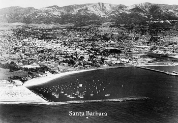
Within months of the breakwater’s 1929 completion, panicked engineers connected the breakwater to shore to cut off the flow of sand into the harbor. However, this caused a rapid build-up of sand on the west, or upcoast, side of the structure (Figure 1). The breakwater successfully blocked waves from reaching the harbor—exactly what it was designed to do—but, in the process, it also blocked wave energy that transported sand along the shore. The interruption in sand flow led to rapid erosion of beaches downcoast, where observers described the beach as “stripped of sand down to hardpan and cobbles.”Footnote 4
Santa Barbara’s harbor in 1935. Note the accumulation of sand against the short edge of the breakwater (left) and the wide beach within the harbor. Source: “Aerial view of Santa Barbara and the harbor from the ocean, ca.1935,” University of Southern California Digital Library and California Historical Society.

This essay argues that coastal waters were active agents shaping the history of California’s coast. This agency took the form of independent action—from rivers changing course to storms buffeting the coastline—as well as interactions with human efforts to transform the coast. Even as developers and engineers sought to stabilize an inherently dynamic coastal environment, recurring hazards revealed the limits of their control. Interactions between water and people had direct physical effects, often in the form of unintended consequences from structures such as the Santa Barbara breakwater, but those interactions also altered people’s understandings of coastal environments. In particular, unexpected outcomes when natural forces, such as water and sand, encountered coastal engineering projects led to new scientific research and attempts to partner with waves and sand to design a coastline that would serve human needs. Ultimately, dynamic coastal processes driven by water co-created California’s coastline with the state’s human residents.
Recent scholarship across the environmental humanities has embraced new materialist thinking that recognizes the agency of the more-than-human world. As Jane Bennett asks, what if we viewed “technological and natural materialities” as “actors alongside and within us—vitalities, trajectories, and powers irreducible to the meanings, intentions, or symbolic values humans invest in them?”Footnote 5 Theorizing the agency of matter has the potential to challenge the modernist hubris behind the “belief that powerful humans and their cultures are distinct from the natural material world,” as Timothy LeCain explains.Footnote 6 In the process, new materialism offers historical insights and potential paths to navigate the Anthropocene.Footnote 7
Water differs from the inert “objects” or “things” that have been the focus of much new materialist analysis. Water is characterized by motion and movement, in some ways occupying a liminal space between fixed objects and living entities. While scientists have long recognized water’s physical power, humanists have often relegated it to the background of their narratives. Attention to more-than-human agency in history also requires thinking across different time scales and considering intersections of those temporalities with human ones. For example, water acts on the coast through the constant (if variable) action of waves and tides. Storms—and the high tides, powerful waves, and floods that accompany them—represent more sporadic, unpredictable, and often uncontrollable influences. In California, water also joins with geological forces in deep time shaping of the landscape. Many Indigenous traditions have always understood water to be a living entity, reminding us that Western nature/culture divisions represent one cultural perspective, not a universal truth. This essay’s emphasis on the agency of water in shaping coastal environments thus contributes to a broader rethinking of Western epistemological preeminence and its past, present, and future environmental consequences.
This essay uses select examples from California history to illustrate water’s force as an active agent in the state’s coastal history. I hope this brief discussion will provide a framework for historians in thinking about the power of coastal waters across time and space.
Coastal Geography and the Role of Water
Water produces the physical geography of the California coastline across temporalities. Waves erode cliffs along rocky portions of the coast, and sandy beaches are even more strongly subject to the force of water. Wave action shapes and reshapes beaches according to daily, seasonal, and long-term cycles. Wave action provides the energy that drives littoral drift—the scientific term for the movement of sand along the coast, a flow often described as a “river of sand.” Seasonal changes of beaches can be dramatic and highly visible. In winter, powerful waves wash sand out to sea where it gathers in berms. The gentler waves of spring and summer then push the sand back to shore, restoring the beaches.Footnote 8 At Santa Barbara, local observers believed that the “average seasonal fluctuations of the elevation of the sand surface” were roughly six feet during the period from 1929 to 1935, and a single storm could remove and replace four feet of sand.Footnote 9
Coastal cliffs and bluffs are exposed to constant wave action, and water from the land also affects cliff stability—urbanization has accelerated cliff erosion by increasing runoff from street drains, landscape watering, and altered drainage patterns. Retreat or collapse is often an episodic process in which a seemingly stable cliff suddenly fails, usually during a wet winter. In the El Niño winter of 1983, one seacliff in Santa Cruz that had eroded a total of twenty-five feet in the preceding half century suddenly lost forty-six feet of clifftop.Footnote 10
While ocean waves represent the most obvious influence of water on California’s shoreline, rivers connect the coast with inland environments, adding another dimension to water’s influence. The Los Angeles River illustrates the dynamism and agency of water. Today, the river is perhaps most famous for its invisibility—its usually dry concrete channel has been the backdrop for many movie scenes.Footnote 11 However, the Los Angeles River was central to human settlement in the region for thousands of years of Indigenous habitation, continuing into the era of Spanish and Mexican control. In the early nineteenth century, the river flowed in a generally westward direction, with its outlet at the Ballona wetlands on Santa Monica Bay. However, during floods in 1815, 1822, and 1825, the river changed course dramatically, moving its outlet far to the south to San Pedro Bay. Smaller changes in the river’s route occurred with later floods in the nineteenth century, including massive floods in 1861–1862 that turned much of Los Angeles into a lake covering twelve miles.Footnote 12
Such floods brought both fresh water and sediment to the coast. Historically, sediment carried by rivers provided as much as 80 to 95 percent of beach sand, with most arriving in the aftermath of large storms.Footnote 13 One flood in 1914 deposited so much silt into the Los Angeles and Long Beach harbors that one observer described “muddy waters” extending “miles beyond the [Long Beach] breakwater to sea.”Footnote 14 Reports published in the aftermath framed sediment as damage to the harbors, rather than as sand supply for beaches. In one, engineer Charles T. Leeds explicitly addressed “the problem of protecting the harbor district from flood borne silt deposits” and emphasized that Los Angeles County could help the harbor by “controlling the upper rivers.”Footnote 15 This imperative to protect harbors and to control the unpredictable floods of Southern California rivers through dams and flood control infrastructure created new problems for the coast by removing crucial sources of beach sand in the twentieth century.
Cities and Hazards
While modern cities promise control of natural forces, urban environmental historians (among other scholars) have uncovered the illusory character of the separation of city and nature.Footnote 16 The history of California’s coastal cities shows water’s enduring importance in shaping the state’s history. Ocean-born commerce brought people and goods to San Francisco during the Gold Rush boom of the mid-nineteenth century. Demand for waterfront real estate and for flat land on the hilly San Francisco peninsula led early developers to build out over the water, filling in mud flats and tidelands to create new real estate. In 1847, the city auctioned off newly surveyed shoreline property consisting largely of “water lots” that were under water at high tide. The new owners built wharves and filled in their property using sand from inland hills and dunes as well as trash and debris. This transformation of water into land erased the area’s original cove by 1849.Footnote 17
While “making land” solved several problems for early residents of San Francisco, it created others. Filled land was prone to subsidence, and heavy buildings compressed the mud beneath them, creating what historian Matthew Morse Booker describes as “a submarine wave of mud that slowly pushed out into the bay.” Engineers constructed a seawall to harden the boundary between land and water, holding in fill and keeping water out.Footnote 18 However, another hazard of unstable made land became apparent when earthquakes struck the city, most dramatically the “Big One” in 1906. In neighborhoods built on fill, water and gas pipes shattered, streets buckled, and structures collapsed or even sank into the ground. Liquefaction—in which unconsolidated soil behaves like a liquid, even losing the capacity to support structures—revealed what Booker calls “ghost tidelands.” Blocks that had formerly been water or wetlands suffered the most severe damage during earthquakes, showing how water that had seemingly been erased from the map continued to affect the city.Footnote 19
Cliff collapses represent another example of episodic hazards at the intersection of water, land, and history. Collapses both fast and slow have periodically forced retreat from neighborhoods along California’s coast. In 1929, a landslide at Point Fermin in San Pedro forced abandonment of a neighborhood of homes overlooking the Pacific. Remnants of foundations, streets, and infrastructure can still be seen in the area, which is known as Sunken City. Beginning in 1956, over several years, a large slide destroyed more than 150 homes in the Portuguese Bend development nearby on the Palos Verdes Peninsula. Geologists had identified and mapped the slide area, but developers ignored their warning. Underground water is a primary cause of such landslides, and water draining from septic tanks, landscape irrigation, and other urban uses makes landslides more likely, if not inevitable.Footnote 20
California’s history of liquefaction and landslides shows how control of water in urban coastal environments has been ephemeral and contingent. Water continues to influence even the most urban of places, even if it bides its time underground for a while.
Coastal Engineering and Science
Beginning in the late nineteenth century and continuing throughout the twentieth and twenty-first centuries, Californians reengineered their coastline for reasons ranging from the commercial to the recreational. Our example here returns to the Santa Barbara breakwater. In the spring of 1936, government officials, engineers, and local elites organized the California Beaches Association to address a perceived crisis facing the state’s beaches. E. B. Brown, City Engineer of Santa Barbara, presented the situation as a conflict between “man” and “nature,” declaring “nature has taken revenge … demonstrating superior power and skill by scouring out thousands of yards of Santa Barbara’s once choice beaches.”Footnote 21 Many statements from the time echoed Brown in implicitly recognizing the agency of waves and sand in shoaling harbors and erasing downcoast beaches.
The crisis inspired extensive study by leading scientists and engineers seeking solutions. Oceanographer Willard Bascom noted the challenges of perceiving coastal processes such as littoral drift, writing of how “the actual shifting of the beach materials takes place under water and since the human mind cannot very well remember and compare the previous position of the surface with some later position, it may appear that little or no change is taking place.”Footnote 22 Bascom described how coastal processes resist human perception through their scale and their constancy of movement and change. The medium of water further challenges human perception of changes taking place along the shoreline. Somewhat paradoxically, by interfering with normal wave-driven movements of sand along the coast, structures such as breakwaters helped make those processes visible to scientists, rapidly advancing knowledge about coastal processes. Two other scientists, John W. Handin and John C. Ludwich, explicitly noted this in a 1949 report on research conducted in Santa Monica, writing, “The problem of sand transport by a longshore current is clarified by observing the effect of a breakwater on this current.”Footnote 23 Coastal engineering structures—particularly the ones that had dramatic unintended consequences—helped scientists to understand how wave action shaped the coast, and they in turn sought to adapt structures to those natural forces.
By the 1940s, engineers planned ways to partner with waves to maintain harbors and beaches. In 1948, the Army Corps of Engineers described the regular dredging of Santa Barbara’s harbor as a successful adaptation and a model for other coastal cities:
At Santa Barbara, a new sand fill is placed on a feeder beach down coast from the harbor breakwater at approximately 2-year intervals to serve as a stockpile from which the down-coast beaches are nourished by littoral drift. The fill material is dredged from shoal depositions carried into the harbor from the upcoast beaches by littoral drift.Footnote 24
This quotation suggests that, once the sand is dredged and placed in the correct location, littoral drift will take over and transport sand to beaches in need. The idea of a “feeder beach” thus implies a kind of partnership between people and waves, with the shared project of maintaining the width of desired beaches.
Knowledge that scientists and engineers gained through studies of wave action and sand movement in Santa Barbara and Santa Monica led them to develop new models for mid-twentieth-century coastal engineering projects in Marina del Rey and Newport Beach. They began to employ feeder beaches, planned (rather than emergency) dredging, and carefully designed coastal structures (including breakwaters) to create hybrid landscapes. These hybrid landscapes represented modified versions of the natural littoral cell in which sand was supplied by people but moved by waves.Footnote 25 Although Santa Barbara’s harbor continues to require regular dredging, coastal engineers largely succeeded in stabilizing beaches to the south along Santa Monica Bay. The wide sandy beaches beloved by visitors and locals alike represent the product of scientific research and a partnership between people, waves, and sand.
Conclusion
How has water spoken in the history of coastal California?Footnote 26 It spoke through erosion and landslides that represent the confluence of gradual wear on the land and storms that brought vast quantities of water and sudden transformations to local landscapes. It spoke through floods that carried water and sediments—along with debris and trash—from inland landscapes to the coast. It spoke when water believed to be contained and transformed into land resurfaced during earthquakes. And it spoke as waves that moved sand and, in doing so, disrupted coastal engineering projects and coastal economies. Dynamic coastal processes—powered in large part by water—shaped the history of California’s shoreline, co-creating a hybrid coastal landscape with the state’s human residents.

 Open access

