

In 1497, Vasco da Gama set sail from Portugal in search of an eastern route to Asia and its legendary lands of gold and spices. Navigating southward along the western coast of the African continent, he ventured into previously uncharted regions, permanently exposing Europe to a global diversity that would never again be closed off. As a result, during the sixteenth century, the European episteme was overwhelmed by an intense influx of ethnographic, physiographic, climatic, linguistic, cultural, technological, economic, political and spiritual information. This torrent of new knowledge challenged traditional Western categories of understanding and compelled a process of intellectual reconfiguration.Footnote 1 The inventory of the world expanded exponentially through direct observation based on personal experience, in contrast to the medieval tradition of book learning, which derived knowledge from ancient textual authorities in the field of natural history.Footnote 2 The newly unveiled and continuously expanding Asian horizon – much like the American – founded on empirical observation and direct experience, posed a fundamental challenge to European knowledge of the world. However, its most immediate impact was reflected in geographic understanding and the development of cartographic representations.
The vast amount of information generated by the Indo-Pacific expansion led by the Portuguese Crown was channelled into the development of an extensive body of cartographic materials, as well as geographic and cosmographic literature in both manuscript and printed forms. Initially, the dissemination of such materials – and of ‘maritime knowledge’ in general, understood as the circulation of pilots, sailors, cartographers, cosmographers, and nautical documents such as rutters, maps and treatises – was subject to strict restrictions imposed by imperial policies.Footnote 3 Since geographical knowledge was intrinsically linked to the rise of the nation-state and held pivotal importance for the early stages of expansionist processes, European maritime powers, particularly the Iberian kingdoms as pioneers in transoceanic discoveries, implemented a series of legislative measures to prevent this information from reaching their rivals.Footnote 4 Framed within what became known as the política do sigilo, a set of regulations was enacted in Portugal as early as the reign of King Manuel I (1469–1521) to prevent the excessive dissemination of nautical knowledge beyond its borders.Footnote 5 Similarly, the Casa de Contratación in Spain prohibited the free circulation of nautical charts or any geographic information about the Indies and banned the sale of cartographic materials to foreigners.Footnote 6 However, despite these restrictions imposed by imperial authorities, the informal transmission of geographic knowledge and cartographic materials proved impossible to control by any single power – be it the Iberian, French, or English Crowns, or the Dutch Republic.Footnote 7 Following the categories established by José María Moreno Madrid, the circulation of such knowledge in Early Modern Europe occurred through two primary mechanisms: illicit appropriation, including espionage and theft, and brain drain, whereby foreign professionals – such as sailors, merchants, travellers or cartographers – were hired to enhance the contracting party’s expertise.Footnote 8 Both practices facilitated access to information among all actors involved in maritime expansion and overseas colonisation, laying the groundwork for what Ofer Gal has conceptualised as ‘global knowledge’.Footnote 9
The circulation of literary and material culture, technology, knowledge and populations across different parts of the early modern world has become an increasingly prominent field of research among historians, as evidenced by the present special section. In recent years, a global historical perspective has emerged, underscoring the significance of knowledge circulation – in its multiple forms – in the processes of cultural exchange that took place across the world during the early modern period. This article aligns with this historiographical trend by examining European geographical knowledge and cartographic representations of the Korean peninsula as a case study. Moving from broader theoretical frameworks to concrete analysis, it explores how ethnographic knowledge about East Asia was acquired, disseminated and received in Renaissance Europe through the first Western maps and writings related to Korea. The profound lack of knowledge about the peninsula in the West, prior to the settlement of Portuguese and Spanish traders and missionaries in what is commonly referred to as Iberian Asia, enables us to trace the circuits through which information about Korea circulated among European learned circles during the sixteenth and seventeenth centuries. Within the Western body of knowledge, Korea was a tabula rasa, making it possible to track, from its very origins, the development of geographical knowledge about the region as compiled by members of religious orders – particularly the Jesuits, who played a central role in transmitting this information. As will be examined below, Korea first entered the European episteme in broad terms, shaped by Jesuit reports on the Imjin War produced within the Japanese mission, before its depiction gained greater spatial precision through the work of their counterparts based in Ming China. Nevertheless, this epistemological process was far from linear. The Imjin War, in a tangible way, put Korea on the map for Europeans – but not always on the same map. The occasionally divergent information that missionaries and other European actors drew from the Chinese and Japanese pathways ensured that inaccuracies, contradictions and ambiguities marked the process by which the Korean peninsula was incorporated, with a ‘precise’ representation, into the emerging global conception of space taking shape in Europe during the Age of Discovery.Footnote 10
Korea ignota
Tzvetan Todorov asserts that the era of Iberian transoceanic expansion did not produce a sense of radical strangeness among Europeans, given that they had never completely lost awareness of Africa, India or China. The memory of these regions had been present in the European episteme since its very origins.Footnote 11 However, this reality does not apply universally to all territories and populations – Korea being a notable exception. In fact, by the year 1500, the only piece of European knowledge about Korea consisted of no more than a few brief lines written by Marco Polo (1254–1324). In these, he used the term Cauli or Kao-li to describe the Korean kingdom of Goryeo (918–1392) as one of the regions subjected to Kublai Khan (1215–94).Footnote 12
In contrast, Islamic cartographic and geographic traditions had developed a considerably more nuanced understanding of the region. As early as the ninth century, geographers such as Ibn Khurdādhbih (c. 820–913) and travel writers like Sulaymān included Korea – referred to as Al-Shila, a transliteration of the Silla kingdom (57 bce–935 ce) – in their accounts.Footnote 13 These descriptions emphasised the peninsula’s insular character, mountainous terrain, pale-skinned inhabitants, temperate climate and notable abundance of gold.Footnote 14 Portrayals of Silla as an earthly paradise for Muslim travellers significantly enhanced its appeal among later medieval authors, establishing it as a recurring motif in Arabic travel literature.Footnote 15 Nevertheless, this geographical knowledge accumulated by the Arab world about Korea did not find its way into Christian Europe.
Despite the central role of Arabic knowledge in shaping medieval European science – particularly in the fields of astronomy, medicine and philosophy – Islamic geography followed a markedly different trajectory. Arabic geographical treatises, travel narratives and maps were never translated into Romance languages, rendering much of this material largely inaccessible to the Christian world, even when its authors lived and worked in Muslim Spain. The reasons for this limited transmission remain unclear.Footnote 16 While it is conceivable that certain geographic ideas or general notions – such as the perceived insularity of the Korean peninsula – filtered indirectly into European thought, such influence appears to have been both fragmentary and largely unacknowledged. Thus, it can be broadly stated that the geographic knowledge accumulated in the Islamic world regarding Korea effectively vanished from the European intellectual horizon.
The isolationist policy implemented by the Korean government to restrict access to the peninsula for any Western foreign agents meant that, despite the Portuguese – followed later by the Spanish and the Dutch – establishing themselves in neighbouring territories, they were unable to establish direct contact with Korea until the nineteenth century.Footnote 17 As a result, much of the European knowledge about Korea was filtered through the Jesuit medium.Footnote 18 It was Catholic missionaries, primarily members of the Society of Jesus, engaged in proselytising activities in China and Japan, who became the principal collectors and transmitters of information about the Korean kingdom. Indirectly, by interacting with native Chinese and Japanese populations – particularly merchants, sailors and fishermen – the missionaries picked up fragments of information about Korea. In fact, the first reference to the peninsula found in the vast Jesuit textual corpus originates from Anjirō (?–1550), the first recorded Japanese convert to Christianity. He worked as a merchant in Malacca after being exiled from Japan under accusations of murder. In 1548, Father Nicolao Lancillotto (?–1558), rector of the Colegio de San Pablo in Goa, interviewed Anjirō to gather information about his homeland in preparation for establishing a missionary presence there. As a result of this meeting, from which Lancillotto compiled a report for the Jesuit superiors in Rome, the Society of Jesus learned that south-east of China there was a nation called Coree, with which the Japanese maintained trade relations and from where they imported textiles (panos d’algodão).Footnote 19
As the decades passed and the Jesuit mission in Japan became firmly established, the Ignatian missionaries began to envision potential plans for the evangelisation of the Korean peninsula. Consequently, references to Korea in their textual production gradually increased, albeit at a very slow pace. The Portuguese Jesuit Gaspar Vilela (1526–72), acting under the orders of the Society’s superior in Japan, Cosme de Torres (1510–70), was the first missionary to attempt such an endeavour in 1566. However, Vilela failed in his objective of establishing a Christian mission in Korea due to what he described as ‘the wars along the way’ – that is, the instability prevailing in Japan at the time. Nevertheless, he documented his intentions in a letter addressed to Francisco de Borja (1510–72), in which he emphasised the need to make another attempt in the future. This letter, dated 4 November 1571, contains, in broad terms, the fragmented and imprecise knowledge the Jesuits had about Korea at that time. According to Vilela, Korea (Corai), inhabited by ‘white people’, was located ‘ten days’ journey by sea’ and marked ‘the beginning of Greater Tartary’. He further claimed that if one continued travelling forward, it was said that one could reach ‘High Germany’. Additionally, Vilela noted that ‘through this land you [could] go to the great city of Poquiu [Beijing], where the king of China lives’.Footnote 20 This statement suggests that, indirectly and perhaps unintentionally, the Portuguese missionary correctly acknowledged Korea’s peninsular nature – an understanding that would later become a source of confusion.
Most of the (scarce) Jesuit writings containing references to Korea prior to the 1590s and the Imjin War were intended for internal circulation within the Society of Jesus. Although a vast number of Jesuit writings were meant to be published and commercially distributed across Europe in multiple editions and languages, none of them referred to Korea. Instead, their primary focus was on the Japanese mission and the extensive news surrounding it. In fact, the only document related to Korea that can be identified as accessible to the European literate public was Vilela’s letter, which was printed in a book-letter published in 1575, known as the Cartas de Alcalá.Footnote 21 Thus, the embryonic knowledge that missionaries had gradually accumulated about Korea during the early decades of their presence in East Asia eventually made its way into Europe, albeit at a very slow pace. This was reflected in the European cartographic repertoire.
None of the widely circulated world maps, planispheres or geographical texts of the sixteenth century included a depiction of Korea. Neither the Cantino Map nor the Cosmographia of Sebastian Münster (1488–1552) – the single most important source of geographical, historical and scientific knowledge of its time, published in all major European languages in more than thirty-six editions over a century – made any reference to Korea.Footnote 22 Initially, Korea was even omitted from the earliest edition of the Theatrum Orbis Terrarum of Abraham Ortelius (1527–98), the first modern atlas, published in 1570 and the most widespread and influential Western portrayal of East Asia for nearly seventy years, with more than 2,000 copies sold.
It would be in Goa, the capital of Portuguese India, where the first Western cartographic depiction of Korea was produced, not in a printed map, but in a carefully crafted manuscript. Fernão Vaz Dourado (1520–80), a military officer and cartographer, produced at least four different nautical atlases between 1568 and 1580, each comprising approximately fifteen charts or folios. These works integrated over half a century of accumulated nautical knowledge generated in Goa – an important hub at the intersection of the Spanish and Portuguese empires – as well as insights probably obtained through his interactions with missionaries based in India. Among his extensive cartographic output, Dourado included two notable representations of Korea, the earliest dating to 1568 (Figure 1). In a detailed and large-scale map of Japan – remarkably, the first in which the archipelago is depicted independently on a chart, and in a distinctive crescent shape – the Portuguese cartographer included, in the upper left section, a land mass of considerable size. This land mass, whose insular or peninsular nature is left ambiguous, borders to the north with the ‘reinos da China’ and bears the label ‘costa de Conrai’. In contrast to the richly annotated depiction of Japan, the only additional textual reference relating to Korea is the toponym ‘I. dos Ladrões’ (Thieves’ Island). This toponym, which would recur in later maps drawing from Jesuit and Portuguese sources, usually referred to one or more small islands located at the southernmost tip of the land mass identified as Korea. Given its location, it most likely designates Cheju Island, although the possibility of a cartographic error cannot be excluded, as the Mariana Islands were also historically known by that name. This first cartographic representation of Korea is further embellished with illustrations of four Buddhist pagodas or shrines, consistent with the iconographic and chromatic richness that characterises Dourado’s work, as well as a prominent inland lake from which several rivers emerge.Footnote 23 Three years later, a reduced version of this same map was included as the eighth chart of his Atlas universal – arguably one of the most renowned folios among Dourado’s surviving works – which meticulously depicts the coasts, archipelagos and numerous islands of the Eastern Indian Ocean, the South and East China Seas, and the entrance to the Pacific Ocean, reaching as far as the Tordesillas meridian.Footnote 24 In this version too, Korea appears as a vaguely defined land mass, rendered at an exaggerated scale (Figure 2). Nevertheless, both of Vaz Dourado’s maps hold great significance, as they constitute material evidence that Korea – albeit peripherally – had begun to be incorporated into the European spatial understanding of Asia.
F. Vaz Dourado, ‘Iapam’, 1568. Casa de Alba Foundation. Image via Wikimedia Commons. https://commons.wikimedia.org/wiki/File:Iapam_by_João_Vaz_Dourado.jpg

F. Vaz Dourado, Atlas [eight chart], 1571. Biblioteca Nacional de Portugal, Manuscritos Reservados, IL.171. https://purl.pt/400

Vaz Dourado’s cartographic depiction of Korea, like all those that followed in the next century, was never specific to the peninsula. That is, Korea was never depicted in a stand-alone map but rather referenced within world atlases or maps primarily focused on China or Japan. This is also the case with the planisphere of Urbano Monte (1544–1613), the next European cartographic projection of Korea, which would take more than a decade to emerge. Composed of sixty-two separate maps, Monte’s planisphere was created in 1587, drawing on the knowledge disseminated through Jesuit texts and maps of Japan that had circulated in Europe up to that time.Footnote 25 More importantly, it was probably shaped by the direct contact its author had with members of the Tenshō Embassy (1582–90). This delegation, composed of four Japanese adolescents, was conceived by the Jesuit visitor Alessandro Valignano (1539–1606) and travelled across southern Europe to pay homage to King Philip II and pledge obedience to the Pope. Their mission was to promote the Catholic enterprise in Japan, secure financial and political support from the Holy See and European monarchies, and impress upon the young delegates the magnificence of Western civilisation. Upon their return to Japan, they were expected to serve as a foundation for a new phase of evangelisation, led by native clergy.Footnote 26 From the cosmographic knowledge he obtained through this embassy, Monte depicted Korea (Corai) as a small, highly schematic island, without any accompanying toponym.Footnote 27 Moreover, it appears to have been added belatedly, as it is not coloured like the rest of the countries.Footnote 28 This representation thus differs significantly from that of Vaz Dourado. While there is some development in spatial knowledge of East Asia – evident in the complete depiction of the Sea of Japan – Monte’s map remains riddled with inaccuracies stemming from ignorance, the dissemination of errors and the lack of reliable data. These flaws highlight the fact that, in sixteenth-century Europe, there was no ‘singular global geographical knowledge of Korea’.Footnote 29
Korea insula
European knowledge of Korea experienced exponential growth as a result of the conflict known as the Imjin War (1592–98). After unifying Japan under his rule and subjugating the remaining feudal lords (daimyo), the hegemon Toyotomi Hideyoshi (1537–98) launched a campaign of continental expansion aimed at overturning the Sino-centric system that governed the region and positioning himself at the centre of a new order. Given Japan’s limited naval tradition, Hideyoshi first opted to invade the Korean peninsula, intending to use it as a launching platform for his ultimate objective: an attack on China. This Japanese expansionist ambition triggered a war that, in terms of the number of troops mobilised, became the largest global military conflict of its time.Footnote 30 A significant number of Jesuit missionaries saw the Japanese invasions as an opportunity to advance their long-aspired mission of evangelising Korea, a territory that had remained inaccessible until then. Consequently, the Ignatian missionaries devoted substantial resources to gathering information about the course of the war – especially since a large proportion of the Japanese frontline troops were composed of Christian daimyo, their major patrons. This Jesuit interest was reflected in their textual production, which contains a vast catalogue of references to multiple aspects of the conflict.Footnote 31
The missionaries drew upon multiple sources of information to acquire knowledge about the war and, inherently, about Korea. First, members of the Society of Jesus gained first-hand knowledge through their two fellow Jesuits, Gregorio de Céspedes (1551–1611) and Francisco de Laguna (1552–1617), who, on separate journeys, entered Korean territory to provide spiritual assistance to the Japanese Christians engaged in combat there. However, the information they were able to gather was limited, as they could only travel within the fortifications in the south of the country, where the Japanese forces were stationed midway through the war, after their initial advance had been repelled by the Koreans with the support of Ming troops.Footnote 32 For this reason, the majority of the information available to the Jesuits came from their native informants. Clear evidence suggests that throughout the six years of the war, the Ignatian missionaries maintained direct epistolary correspondence with Konishi Yukinaga (1555–1600), Arima Harunobu Protásio/Juan (1567–1612), Ōmura Yoshiaki Sancho (1568–1619), and other Christian daimyo engaged in the fighting in Korea.Footnote 33 Additionally, on the rare occasions when these daimyo were forced to return to Japan to report to Hideyoshi on the progress of the battles against the Chinese and Koreans, the Jesuits took advantage of the opportunity to meet with them in person under the pretext of offering confession. For example, the Italian Jesuit Francisco Pasio (1554–1612) transcribed all the information that Konishi Yukinaga provided him during a meeting in Nagoya in the autumn of 1593: ‘Going to Nangoya [Nagoya-Hizen] to hear the confession of Agustín [Yukinaga] himself, […] I spoke privately with him […]. It seemed appropriate to the vice-provincial that I write a brief account of the events of this war between the Japanese and the corias up to this point.’Footnote 34
Alongside the converted daimyo, the Jesuits also relied on another group of informants to obtain information: the Korean captives taken by the Japanese and sent to Japan. A significant portion of this captive Korean community was settled in Kyushu, where Christianity had a strong presence, fostering frequent interactions between the captives and the missionaries. In fact, several thousand Koreans converted to Christianity, with some even joining religious orders. They became a pillar of the Japanese Church during the Tokugawa persecutions, playing a crucial role in the clandestine network of converts that emerged at the time.Footnote 35 Finally, the missionaries also obtained information about the war and its theatre through documents circulating in Japan. Thanks to the converts within the country’s ruling elite, the Jesuits had access to private materials reflecting the strategic plans of the Japanese high command. Through this privileged access, for instance, they were even able to examine a map used by Hideyoshi to plan the invasion, in which Korea’s eight provinces were distinguished only by different colours – a clear indication of the limited geographical knowledge the Japanese had of the Korean peninsula.Footnote 36
To provide their European readers with contextual information about the battlefield, the missionaries included a vast array of ethnographic data on Korea in their chronicles, drawn from the sources available to them. Some of these references – covering aspects such as geography, political structure, vassal relations with China, flora and fauna, economy, warfare and Korean society – were incorporated into the private correspondence that Jesuits maintained with their superiors in Rome. However, in most cases, this information appeared in texts produced by the Society of Jesus for public dissemination. European literate audiences gained access to this new knowledge about Korea primarily through the annual letters (Annuae litterae), which were printed in multiple editions and languages – Italian, French and Latin – and widely distributed across Europe. The annual letter of 1589–90 and 1591–92, written by Luís Fróis (1532–97), those of 1593 and 1594, compiled by Pedro Gómez (1535–1600), and a collection of letters from the same period by Organtino Gnecchi-Soldo (1530–1609), introduced a new body of knowledge about Korea to the West.Footnote 37 For instance, they provided new geographical data: ‘This kingdom of Coray is said to be approximately 160 of our leagues in length and around 60 in [width]’.Footnote 38 In addition to these reports, the publication of the Historia of Luis de Guzmán (1544–1605) in 1601 further contributed to the European understanding of Korea. Although Guzmán never travelled to Asia, his work – highly influential in its time – relied on first-hand testimonies and both public and private materials in the possession of the Society of Jesus. Among the various histories of the Ignatian evangelisation efforts in different overseas territories, his account traces the Jesuit mission in Japan from its very beginnings until the death of Toyotomi Hideyoshi, dedicating a significant portion of its final pages to Korea and the Japanese invasions. Guzmán is arguably the Jesuit author who compiled the most extensive body of information on Korea in a single work. His descriptions contain increasingly precise details about the geography of the peninsula:
The kingdom of Coray is 80 leagues north of Firando [Hirado], an island of Japan. It lies at a latitude of thirty-five degrees, which amounts to 250 leagues by Japanese reckoning. It borders and is connected with three nations: the Chinese to the north and north-east, the Tartars and the Orancai.Footnote 39
Guzmán’s text, however, reveals that significant gaps – or at the very least, ambiguities – still existed in European knowledge regarding Korean geography at the dawn of the seventeenth century. Influenced by the accounts provided by the Christian daimyo who had fought in Pyongyang, the Spanish missionary stated that Korea was an island, as it was separated from China by a river – the Yalu: ‘The island of Coray, also called Coria, lies near the province of Panquin [Beijing], where the King of China resides, as these two kingdoms are separated in that region only by a mighty river, three leagues wide.’Footnote 40 In this regard, the Italian merchant Francesco Carletti (1573–1636), who visited Japan in 1597 during his circumnavigation of the globe, recorded that the Jesuit-Portuguese community in the Japanese archipelago did not hold a unanimous view on whether Korea was an island or a peninsula: ‘A peninsula connected to the mainland of China, according to some. Others say it is separated by a small sea channel that surrounds it entirely, running between the mainland and the said peninsula, or rather, island, commonly called Coreà.’Footnote 41
Although in a fragmented and unstructured manner, Jesuit writings functioned as a kind of encyclopaedia for European audiences of the time, in the strictest sense of a ‘compendium of knowledge’ – particularly on Korea, but also on Asia more broadly. These Jesuit letters did not circulate exclusively among Catholic powers but also reached literary circles in Northern Europe, as some were translated and incorporated into English and Dutch works. A paradigmatic example can be found in Richard Hakluyt’s (1552–1616) The Principall Navigations, a seminal work compiling accounts of English expeditions by explorers, traders and travellers across the world over a span of 1,500 years.Footnote 42 First published in 1589, Hakluyt’s work saw an expanded edition released between 1598 and 1600, which included translations of two letters from 1590 and 1594, written by Luís Fróis, that focused on the war, as well as one by Organtino (1595–96), under the title: ‘Three Several Testimonies Concerning the Mighty Kingdom of Coray’.Footnote 43 Notably, these documents on Korea in Hakluyt’s work were introduced by emphasising that it was ‘esteemed at the first an iland, but since found to adjoyne with the maine not many dayes journey from Paqui [Beijing] the metropolitan citie of China’.Footnote 44 Drawing from the previously analysed ambiguous information in the ‘Portugale Iesuites yeerely Iaponian Epistles’, Hakluyt correctly identified Korea’s peninsular nature, making his text one of the earliest literary testimonies to reflect this reality.
While the advancement of geographical knowledge about Korea compiled in textual sources outpaced cartographic representations, there was nonetheless a degree of correlation in their concurrent development. Thus, during the final decade of the sixteenth century, in parallel with the emergence of Jesuit texts on the Imjin War and closely linked to the rise of Western European powers – especially the Dutch – and their pursuit of sea trade with Asia, cartographic representations of Korea became more widespread in European maps. One of the most significant maps from this period accompanies the work of Jan Huyghen van Linschoten (1563–1611), a figure widely credited with opening the Indian Ocean to European geographical imagination.Footnote 45 Born in Haarlem into a Catholic family, van Linschoten served as secretary to the Archbishop of Goa, João Vicente da Fonseca (1530–87). This position granted him access to the extensive library that undoubtedly existed within both the archbishop’s palace and the viceregal palace in what was then the capital of the entire Estado da Índia. Footnote 46 Thus, it cannot be ruled out that this library contained a copy of Vaz Dourado’s atlas, which he may have used as a source, along with sensitive data from the roteiros (nautical routes) written and shared by Portuguese sailors.Footnote 47 In addition to these documentary sources, van Linschoten relied on the vast empirical knowledge possessed by his select group of informants and collaborators, which included the Dutch sailor Dirck Gerrits Pom (1544–1608), who had travelled to Japan on Portuguese ships; Diogo do Couto (1542–1616), the future Portuguese chronicler of Asia; and, given his close ties with the archbishop, it is possible that he also received information from Jesuit visitor and provincial of Asia Alessandro Valignano, although the latter was never explicitly acknowledged as a source by the Dutchman.Footnote 48 Through these sources, van Linschoten became aware of the existence of Korea, a territory about which he claimed to have ‘good, comprehensive, and true information’.Footnote 49 His 1595 work Reys-gheschrift, a compilation of essential contemporary nautical letters, specifically in chapter 30, which focuses on the routes between China and Japan, briefly mentions that between these two countries lie the so-called ‘Islands of Core – as referred to by the Portuguese – although their actual name is Chausien’.Footnote 50 This reference, which reproduces the traditional European geographical misconception of Korea’s insularity, suggests that van Linschoten, albeit indirectly, obtained information from Chinese sources. The term ‘Chausien’ is in fact a transliteration of the Chinese pronunciation of Chosŏn, the Korean dynasty (1392–1897) by which the peninsula was known natively. In his Itinerario (1596), van Linschoten’s other major work, the primary reference to Korea appears in an accompanying map of East Asia, created by Arnold Florent van Langren (1571–1644) (Figure 3). This map once again underscores the scarcity of accurate geographical knowledge about Korea circulating in Europe. Unlike the detailed annotations found on many of the islands of Southeast Asia and the coasts of Japan and China, the Korean peninsula is depicted as a large, featureless circular island, bearing only the widely used Portuguese toponym ‘Ilha dos Ladrões’.
A. F. van Langren, ‘Exacta & accurata delineatio’, in Itinerario, aut. H. van Linschoten (Amsterdam, 1596). Biblioteca Nacional de Portugal, Cartografia, C.C. 804 V. https://purl.pt/30763

The Itinerario enjoyed widespread circulation across Europe, being translated into multiple European languages and with an estimated 10,000 to 15,000 copies printed.Footnote 51 The extensive dissemination of van Linschoten’s work undoubtedly contributed to the misconception that Korea was an island, further embedding it into the European imagination. Additionally, it played a role in the republication of Abraham Ortelius’s map. In 1596, a new edition of the Theatrum Orbis Terrarum was printed, featuring a newly included map of Japan by the Portuguese Jesuit and mathematician Luís Teixeira (?–1604) (Figure 4).Footnote 52 As cosmographer to the King of Spain, Teixeira himself had never been to Asia but presumably copied the map from an author who had either lived in Japan or had direct familiarity with Japanese sources. The leading candidate for this source is Ignacio Moreira (1543? –?), the first European cartographer reportedly to have set foot in Japan.Footnote 53 In this map, Korea is depicted as a vast island, with an elongated land mass extending southward towards western Kyushu. This representation would be adopted by the next generation of cartographers and, alongside van Linschoten’s map, illustrates how, in less than thirty years, Korea emerged from obscurity in European cartographic representations to become a recurring feature – though still marked by a striking lack of accuracy and detail.
L. Teixeira, ‘Iaponiae Insulae Descriptio’, in Theatrum Orbis Terrarum, aut. Abraham Ortelius (Antwerp, 1596). Sophia University, Kirishitan Bunko, JL-MAP-1595-KB1-3. https://digital-archives.sophia.ac.jp/laures-kirishitan-bunko/view/kirishitan_bunko/JL-MAP-1595-KB1-3

Korea paeninsula
The definitive confirmation by Europeans that Korea was a peninsula is inextricably linked to the transformational shift in the sources of geographical knowledge about this territory in the early seventeenth century.Footnote 54 The accounts produced by members of the Society of Jesus involved in the Japanese mission during the Imjin War acted as a crucial vector for the incorporation of Korea into the European geographical episteme. However, these narratives did not significantly contribute to improving the accuracy of Korea’s cartographic representation. Such improvement occurred shortly thereafter, as a result of the accumulated knowledge of Jesuit missionaries engaged in evangelisation efforts in China. The shift in focus in the textual production of Jesuits in Japan – triggered by the first waves of anti-Christian governmental policies – and, more significantly, the success of Matteo Ricci (1552–1610) and his companions in establishing a stable mission in Beijing, led to European knowledge of Korea being filtered through Chinese sources.
The Jesuits engaged in the Chinese proselytising mission made use of cartography, along with mathematics and astronomy, as tools for dialogue with the country’s literate elites. This approach resulted in a substantial expansion of their knowledge of the Asian world. Drawing on both personal experience and, more significantly, Chinese cartographic knowledge, Jesuits produced a series of maps that offered a much more accurate depiction of East Asia. This was particularly evident in the case of Korea. Unlike Japan – whose historical relations with Korea were shaped by mistrust and hostility, most notably the Imjin War, which fostered a certain degree of mutual unfamiliarity – China maintained a tributary relationship with Korea established over a millennium. This political and cultural subordination provided the Ming dynasty with a profound and long-standing knowledge of Korean geography. Jesuit missionaries compiled, assimilated and implemented this knowledge, as evidenced by the work of Michele Ruggieri (1543–1607). In the 1590s, as part of a coordinated effort to persuade ecclesiastical superiors and Catholic sovereigns to increase their support for the Chinese mission, Ruggieri created a map titled Sinarum Regni aliorumque regnorum et insularum illi adiacentium descriptio. This map, which features rich textual annotations alongside its detailed graphical elements, not only accurately represents Korea as a peninsula but also includes a legend in which the Italian Jesuit explicitly clarifies that the previous notion of its insularity had been a mistake (Figure 5).Footnote 55 In 1602, Ruggieri, alongside the Chinese astronomer and mathematician Li Zhizao (1565–1630), assisted Ricci in developing his famous oval planisphere, Kunyu Wanguo Quantu (Complete Map of the Myriad Nations of the World). Following a European model but once again drawing from Chinese sources, this map likewise correctly depicts Korea as a peninsula, incorporating a dozen toponyms written in Chinese characters – a clear testament to the syncretism of Chinese and European geographical knowledge that the Jesuits embodied.
M. Ruggieri, Sinarum Regni aliorumque regnorum et insularum illi adiacentium description, c.1590. Hong Kong University of Science and Technology Library, Antique Maps of China, G7400 1590 .S54.https://lbdiscover.hkust.edu.hk/bib/991009946599703412

The geographical knowledge of China acquired by members of the Society of Jesus circulated fluidly and consistently among their fellow Jesuits, as well as, to some extent, within the Portuguese Empire. A clear example of this is João Teixeira, the son of Luís Teixeira, who, in an effort to represent all territories ‘conquered’ by Portugal, compiled an atlas titled Taboas Geraes (1630). In its ninth map, dedicated to Asia, Korea is depicted as a peninsula – somewhat disproportionate in size but rendered with a remarkable level of detail, particularly in its southern islands.Footnote 56 A more schematic and linear depiction of the Korean peninsula appears in another Portuguese manuscript cartographic document: an anonymous world map that currently decorates the central hall of the Ajuda Palace Library (Figure 6). In the lower-left corner of this map, a pencil inscription theorises about its dating based on European knowledge of Korea at the time: ‘Posterior to 1617, when Bengal was founded. 1598, based on the configuration of Korea’. One particularly notable aspect of both the Ajuda map and the works of João Teixeira and Michele Ruggieri is that all three identify the peninsula as ‘Corea’, rather than ‘Corai’ – the European transliteration of the Japanese reading of the Chinese characters for Goryeo. The latter was the standard term used by Europeans throughout the sixteenth century. This, combined with the fact that the Ajuda map contains additional Korean toponyms derived from their Chinese forms, rather than the Japanese-derived names found in Jesuit chronicles related to the Imjin War, provides clear evidence that the earliest accurate European cartographic representations of Korea originated from geographical knowledge obtained by the Jesuits in the Chinese mission.Footnote 57
Anonymous, World map, c. early seventeenth century. Library of the Palácio da Ajuda. Photograph by the author.

The transmission of this knowledge did not occur synchronously in the secular sphere. The emerging cartographic industry, concentrated mainly in the Low Countries, did not readily absorb the advances in geographical knowledge of Korea produced by members of the Society of Jesus. Jesuit maps were either manuscripts or printed in limited editions, intended primarily for internal use or for distribution among their principal patrons, and thus did not circulate widely among the European public. This, along with the widespread practice of reprinting and reproducing earlier cartographic models, perpetuated the long-standing stereotype of Korea’s insularity in the major atlases printed in Europe during the early decades of the seventeenth century.Footnote 58 A clear example of this can be found in the 1606 Mercator-Hondius Atlas (Figure 7). Seeking to enter the growing commercial map market, engraver and map dealer Jodocus Hondius (1563–1612) acquired from the heirs of Gerardus Mercator (1512–94) the rights to the map plates Mercator had produced for his famous 1585 atlas. Hondius reprinted Mercator’s atlas with a series of additions, including a map of Japan, which he labelled Iaponia. In this map, Korea is depicted following the Ortelius–Teixeira model, appearing as a massive island accompanied by the following Latin inscription: ‘The natives call the land Caoli; the Japanese call it Corai. It is unclear whether it is an island or part of the continent. The natives are fair-skinned and tall in stature. In war, they are brave but cruel and barbaric.’Footnote 59 This statement serves as clear evidence that the geographical knowledge obtained by the Jesuits from their sources and contacts in China took several decades to take root in European epistemology. Some of the most prominent cartographers of the time – Jan Jansson (1588–1664), Joan Blaeu (1596–1673), Philippe Briet (1601–68) and Nicolas Sanson (1600–67) – continued to represent Korea as an island, most following the Ortelius–Teixeira model.Footnote 60 Others produced more accurate depictions, though they still depicted a small river separating the Korean territory from the mainland.
G. Mercator and J. Hondius, ‘Iaponia’, 1606, in Atlas Minor (Amsterdam, 1606). Sophia University, Kirishitan Bunko, JL-MAP-1606-KB1. https://digital-archives.sophia.ac.jp/laures-kirishitan-bunko/view/kirishitan_bunko/JL-MAP-1606-KB1

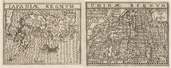
The maps that illustrate travel and geographical literature also reflect the confusion that persisted in Europe during the first quarter of the seventeenth century regarding Korean geography. For example, the massive anthology of travel accounts collected and edited by the English historian Samuel Purchas (1577?–1626), published in 1626 under the title Hakluytus Posthumus or Purchas His Pilgrims, includes a small map of China, based on Hondius’s work, in which Korea is still depicted as an island – clear evidence of the recurring practice of reusing outdated cartographic designs.Footnote 61 On the other hand, the French edition of 1607 of Cornelis van Wytfliet’s (1550/5–97?) Descriptionis Ptolemaicae augmentum provides another curious and highly revealing case (Figure 8). Wytfliet’s original work is recognised as the first atlas dedicated exclusively to the Americas. However, the French translation expanded this content by adding a second book that summarises sources such as Hakluyt and incorporates descriptions of Asia. As was customary at the time, Korea does not appear independently but is instead included within the maps of China and Japan. While the map of China represents Korea as a peninsula, resembling Ruggieri’s depiction, the map of Japan, although only its upper part is visible, labels Korea as ‘Ins[ula]’, highlighting the uncertainty that still prevailed in Europe and how the origin of different sources determined the accuracy of European cartographic representations of Korea.Footnote 62
C. van Wytfliet, ‘Japoniae Regnvm’ ‘Chinae Regnvm’, in Histoire universelle des indes, orientales et occidentales (Douai, 1607). Bibliothèque nationale de France, Société de Géographie, 4-SG BON H-2. https://gallica.bnf.fr/ark:/12148/bd6t57747550?rk=708158;0

It was not until the mid-seventeenth century that a realistic depiction of Korea became widespread across all European learned circles. The concept of Korea’s peninsularity did not take root organically in the European cartographic industry through the gradual integration of the knowledge acquired by the Society of Jesus and the Portuguese in China. Instead, it emerged fortuitously, through the efforts of a single individual. Martino Martini (1614–61) was an Italian Jesuit missionary who travelled to China in 1642 (Figure 9).Footnote 63 There, he acquired extensive knowledge of Chinese geography, history and culture. He was the first Western historian of pre-modern China and the first European to compile a Chinese grammar, earning him recognition as one of the founding figures of Sinology. During his decade in China, Martini gained access to a vast collection of texts and cartographic documents, including the Guang yu tu (Enlarged Terrestrial Atlas), the oldest extant comprehensive atlas of China, compiled by the Ming cartographer Luo Hongxian (1504–64).Footnote 64 This knowledge made him the European with the most advanced understanding of China’s geography and that of its neighbouring countries. Martini’s expertise was reflected in his works, as he authored the first European maps to include the Chinese provinces. He also played a pivotal role in settling the decades-old debate among European cartographers on whether Ezo/Hokkaido was an island or a continent.Footnote 65 Since he relied on Chinese geographical knowledge, Martini depicted Korea as a peninsula in his maps, accurately naming the Yalu river (‘Yalo’), which some of his Jesuit counterparts in Japan had previously mistaken for the boundary separating the peninsula from the mainland. Unlike other cartographic works produced by Jesuits in Ming China, Martini’s maps enjoyed widespread circulation. While returning to Rome, he was captured by the Dutch, who recognised the value of his work and took him to the Netherlands. There, with the assistance of Protestant publisher Joan Blaeu, the official cartographer of the Dutch East India Company (VOC), he published his Novus Atlas Sinensis in 1655.Footnote 66 Martini’s work ultimately solidified the understanding – at least among the educated and literate European public – that Korea was a peninsula. Thus, to apply to Korea Donald Lach’s observation that Japan was ‘firmly put on the map’ barely fifty years after its ‘discovery’, this geographical recognition of Korea would take an additional fifty years to become fully established.Footnote 67
M. Martini, ‘Imperii sinarvm nova descriptio’, in, Novus Atlas Sinensis (Amsterdam, 1655). Library of Congress, Geography and Map Division, G2305 .M3 1655. https://lccn.loc.gov/2002625249

Conclusions
Korea’s incorporation into European geographical knowledge frameworks was neither a linear nor a seamless process; rather, it was marked by ambiguity and contradiction. From the moment Korea entered the European epistemic sphere, multiple and often contradictory geographical descriptions and cartographic representations coexisted, reflecting the uncertainty and fragmentation of the available knowledge. In early modern European documents, Korea is described and depicted in a remarkably diverse range of forms: from an indistinct, featureless land mass vaguely unattached to the Chinese coastline, to a vast, elongated island disproportionately larger than the entire Japanese archipelago, passing through its depiction as a peninsula – sometimes rendered with relative accuracy but often distorted in scale and form. The European cartographic market mirrored this ongoing state of uncertainty, producing a broad spectrum of representations of Korea, and sometimes even within the same body of work. Clear examples of this geographic confusion appear in Cornelis van Wytfliet’s maps and in Joan Blaeu’s Grand Atlas – two major works that simultaneously present multiple, conflicting depictions of Korea, underscoring the persistence of geographical ambiguity well into the seventeenth century.Footnote 68 This lack of consistency can be attributed to the fact that geographical information in graphic form generally took longer to be integrated and standardised than the knowledge contained in written chronicles by explorers, merchants, and, most notably, Jesuit missionaries.
It is well established that members of religious orders engaged in evangelisation efforts – both in the Atlantic and the Indo-Pacific – played a pivotal role in shaping early modern knowledge, particularly in the construction of European perceptions of the West Indies (Americas) and East Indies (Asia). This influence is particularly evident in the case of Korea. The Jesuits stationed first in Japan and later in China, drawing upon first-hand observations and integrating native Asian sources, were the only European group progressively to incorporate a more comprehensive image of the peninsula into their works. Their chronicles – primarily apologetic in tone but, as Antonella Romano notes, also documenting a body of insights that can be considered ethnographic – contributed to the accumulation of substantial direct factual knowledge, which had a lasting impact on European perceptions of Korea.Footnote 69
Before the Imjin War stimulated European interest in Korea, the peninsula occupied only a marginal place within the Atlantic episteme. Europeans could scarcely identify it beyond the name used by Marco Polo, and its image was shaped by an alleged incident involving a Portuguese vessel in the 1570s, during which most of the crew was reportedly massacred by Koreans – an episode that circulated among Portuguese merchants and fostered the perception of Korea as a violent land: ‘Korea […] which is inhabited by barbaric and inhuman people, who do not wish to trade with us at any price. And they say that in the past a Portuguese junk desired to land there, but these fierce people took their boat and all who were in it.’Footnote 70 The acquisition of knowledge by members of the Society of Jesus because of the Japanese invasions produced a simultaneous and radical shift among European groups operating in East Asia in how they regarded Korea and its people, as attested by Guzmán: ‘The people [in Korea] are docile and of good intelligence, and generally white, of great strength.’Footnote 71
However, this knowledge produced during, and as a consequence of, the Imjin War – despite circulating openly across Europe, both in Jesuit publications and in the works of non-Catholic authors such as Hakluyt, who drew heavily on Jesuit sources – do not appear to have had a significant impact on the broader European public. This was particularly true in the realm of cartography. The lack of effective mechanisms for transmitting and compiling geographical information delayed the convergence of evangelisation and cartography as interconnected activities. Consequently, the geographical knowledge accumulated by missionaries failed to be fully translated into the commercial maps that flooded European markets during this period. What reached buyers’ hands was rarely reflective of the most up-to-date geographical notions about Korea. Furthermore, compared to the wealth of information available on neighbouring nations such as China and Japan, knowledge about Korea remained strikingly limited – both qualitatively and quantitatively. While the Korean peninsula was eventually located with accuracy, early modern Europeans continued to have little understanding of its internal reality. The Chosŏn government’s exclusionary policies, which barred any Western presence, meant that European powers showed little initiative in gathering new information about Korea. As a result, the fragmented references compiled by Jesuits during the Imjin War and their proselytising activities in Ming China became – for centuries, with only a few exceptions – the primary source of European knowledge about Korea.Footnote 72 Thus, until the mid-nineteenth century, and from a European perspective, Korea remained the great unknown nation of East Asia.
Supplementary material
The supplementary material for this article can be found at https://doi.org/10.1017/S008044012510056X


 Open access