




In the face of Mercian expansion to the south, the West Saxons abandoned the Upper Thames Valley around Dorchester-on-Thames and reoriented their kingdom around the Hampshire basin in the second half of the seventh century. For the next two hundred years, the northern frontier between Wessex and Mercia marched along the Berkshire Downs.Footnote 1 This article examines the nature of this frontier zone, with an emphasis on the region as a space of mediation in the last decades of the Mercian kingdom, as royal women such as Æthelswith of Mercia (c. 838–888) served as interlocutors between Mercian and West Saxon interests. After the incorporation of the Berkshire Downs into the wider English kingdom, royal women continued to be associated with this landscape as it was transformed from a frontier into an ideologically resonant royal core over the course of the tenth and eleventh centuries.
The Berkshire Downs (see fig. 1) form part of the Cretaceous chalk formation that so marks the geography of southern England. They range from the Goring Gap on the banks of the Thames to the downlands around Marlborough in Wiltshire with which they are contiguous. The northern scarp of the Downs faces the Vale of the White Horse – that is, the valley of the River Ock – and the southern dip-slope is formed by the northern side of the valley of the Kennet. The highest point of the Downs is White Horse Hill, rising some 260 metres above the parish of Woolstone.
Landscape overview of the Berkshire Downs.

Figure 1: Long description
A topographical map uses green to represent lower elevations and light brown for higher terrain. A legend in the Northwest corner identifies a solid brown line as The Wansdyke, a solid orange line as Roman Roads, and a dashed red line as the Berkshire Ridgeway. A scale bar indicates 0 to 15 kilometers.
At the center of the map is the Berkshire Downs, a high-altitude region. The Berkshire Ridgeway dashed line runs West to East across this area, passing Cwichelm’s Barrow.
To the North lies Oxfordshire and the Vale of the White Horse. The River Thames flows through Oxford, Abingdon, and Dorchester-on-Thames. The River Ock is also visible in this northern valley.
To the East, the Chiltern Hills rise, and the River Thames continues Southeast through Wallingford, Pangbourne, and Reading. Eastern Berkshire is labeled in the Southeast quadrant.
To the South is Hampshire, with the River Enborne and River Kennet flowing through the lower terrain.
To the West is Wiltshire, featuring Avebury and the start of the Wansdyke.
Several rivers originate or flow through the central Downs, including the River Lambourn, River Pang, River Dun, and River Kennet. Roman Roads are scattered throughout, notably intersecting near Reading and extending North toward Oxford.
The downlands were recognized by contemporaries as a coherent landscape, and the region was known as Æscesdune in Old English. It is possible that Æscesdune referred to a more expansive pays than just the Berkshire Downs, potentially encompassing the downlands in northeastern Wiltshire as far as the region around Avebury.Footnote 2 The name first appears in the Anglo-Saxon Chronicle in an entry for 648, which claims that ‘in this year Cenwealh gave to his kinsman Cuthred 3,000 hides of land near Æscesdune . Cuthred was the son of Cwichelm, the son of Cynegils.’Footnote 3 As Blair notes, this is a very large valuation that exceeded the later borders of Berkshire. If the entry can be taken at face-value, Cuthred’s territory must have included territory in northern Wiltshire or Oxfordshire, if not both.Footnote 4 Æscesdune is also mentioned in the entry for 661, which reports that ‘Wulfhere, the son of Penda, harried along Æscesdune ; and Cuthred, son of Cwichelm, and King Cenberht died in one and the same year.’Footnote 5 A connection between Æscesdune and the kindred of Cuthred was further strengthened by references in the region to his father, Cwichelm. Rising above the parish of East Hendred is a prominent Iron Age round barrow known as Cwichelmeshlæwe , or Cwichelm’s Barrow. The barrow is referenced by name in a charter of 990 × 992, where it is mentioned as the shire meeting-place.Footnote 6 The barrow is referenced again in the 1006 entry of the Chronicle, as shall be discussed below.Footnote 7 Interestingly, there is a second Cwichelm’s Barrow described in the bounds of Ardley (Oxon.), adjacent to Bicester and Alchester, in which the barrow is described in relation to Akeman Street.Footnote 8 It is possible, but inherently speculative, that the 3,000 hides referred to in the Chronicle reflected the distant memory of a fleeting territory associated with the kindred of Cwichelm oriented around Akeman Street in the north and the Berkshire Ridgeway in the south, thereby extending from the uplands of Æscesdune into adjacent lowlands in the Thames Valley.Footnote 9
In the diplomatic record, a charter of 955 for Compton Beauchamp, on the pre-1974 Berkshire-Wiltshire border, refers to a montem qui dicitur Æscesdune, while the 946 × 947 will of Ealdorman Æthelwold of Wiltshire left land æt Æscesdune to his brother.Footnote 10 Æscesdune also appears in an entry of the Chronicle for 871, describing Æthelred and Alfred’s victory over the Great Army.Footnote 11
As for the name of Berkshire, it first appears in an entry of the Chronicle for 860 and in Asser’s Vita Ælfredi , where the name is – incorrectly – associated with boxwood, suggesting the perception of a coherent character for Berkshire related to woodland.Footnote 12 It is notable that the name of Berkshire does not follow the naming pattern for many other shires, in which the shire name derived from a central place, as in the case of, say, Oxfordshire. Instead, Berkshire takes its name from the Celtic barrog, ‘hilly’, perhaps speaking to the antiquity of the region as a cohesive and distinct landscape that predated the establishment of the shire town of Wallingford.Footnote 13
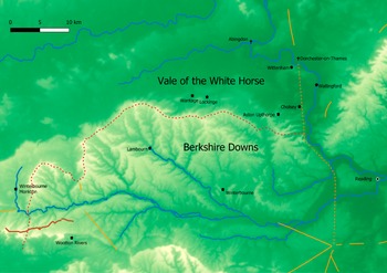
In the eighth century, the Berkshire Downs comprised just one section of a broader frontier zone that ranged from the middle valley of the Thames, across the downlands of Berkshire and northern Wiltshire, into the valley of the Avon around Malmesbury, all the way to Bath in the west. The evidence for the Berkshire Downs as a late seventh- and eighth-century frontier zone between Mercia and Wessex is manifold. In the Abingdon cartulary, there are four charters of Ine of Wessex (r. 689–726) that pertain to the early history of the minster of Bradfield, which lies in the southeast of the Downs along the northern banks the River Pang, about five kilometres south of where the Pang joins the Thames west of Reading.Footnote 14 Adjacent to Bradfield is Englefield, ‘Field of the English’, lying two kilometres to the east (fig. 1).Footnote 15 It is notable that Yattendon, ‘valley of the Jutes’, lies a mere seven kilometres upriver from Englefield and Bradfield, while Tidmarsh (OE Þeod-mersc ), plausibly ‘marsh of the people/nation’, is a mere three kilometres downriver from Englefield/Bradfield, suggesting a remarkable concentration of identity related place-names in the immediate vicinity, and perhaps marking the Bradfield landscape out as a place of assembly.Footnote 16 This is reinforced by the place-name Streatley, eight kilometres due north, which is indicative of a Roman road. This is the conjectural north-south Roman road that may have run from Dorchester-on-Thames in the north to Winchester in the south via Silchester.Footnote 17 The strategic location of Bradfield in the middle Thames Valley, at the nexus of river- and land-based transportation networks on the fringe of the Downs is unlikely to have escaped the notice of acquisitive Mercian and West Saxon kings (fig. 2).
The Eastern Berkshire Downs.
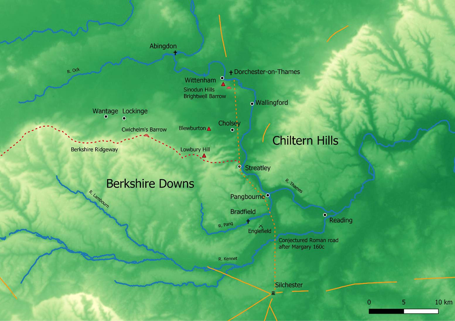
Figure 2: Long description
A topographical relief map using green and yellow shading to indicate elevation.
In the Northwest, the River Ock flows East toward Abingdon. The River Thames enters from the North, passing Dorchester-on-Thames and Wittenham, where Sinodun Hills and Brightwell Barrow are marked with red triangles.
In the West and Southwest, the Berkshire Downs are prominent. The Berkshire Ridgeway is marked by a red dashed line running East through Cwichelm’s Barrow and Lowbury Hill. Nearby settlements include Wantage, Lockinge, and Blewburton. The River Lambourn and River Kennet flow through this region.
In the Center and East, the River Thames curves South through Wallingford, Cholsey, Streatley, and Pangbourne. To the East of the river, the Chiltern Hills rise in elevation.
In the Southeast, the River Thames continues toward Reading. A vertical orange dashed line represents a conjectured Roman road after Margary 160 c, running North to South from Dorchester-on-Thames through Silchester. The River Pang and River Kennet converge near Reading.
A scale bar in the bottom right corner indicates a distance of 10 kilometers.
In their received form, the Bradfield charters are not authentic, but it has been argued that they represent early forgeries relating the foundation traditions of Bradfield which were eventually transferred to Abingdon and revised in the hands of Abingdon scribes.Footnote 18 If these documents do contain genuine fragments of Bradfield’s early history, then they provide an intriguing glimpse into the politics of the Mercian-West Saxon frontier in the late seventh and early eighth centuries. Of the four Bradfield charters, three are of use for understanding the Berkshire Downs as a Mercian-West Saxon frontier. Two of them, S 239 and 241, allude to negotiations with both Ine of Wessex and Æthelred of Mercia to secure the minster’s endowment, with the former including the subscriptions of both kings. S 241 goes further by claiming that the minster received grants on the east-bank of the Thames ( de orienti parti fluminis Tamise ) from Cuthred regulus (perhaps supporting the possibility that Cuthred’s regio spanned the Upper Thames valley in Oxfordshire), Æthelred of Mercia, and Ine of Wessex.Footnote 19 Meanwhile, S 252 claims that the Bradfield endowment was done cum iussione episcoporum Cedde, Germani, Ƿinfridi (‘by order of Bishops Chad, Jaruman, and Winfrid’), three Mercian bishops whose episcopacies can be dated between c. 662 and 672 × 674, and reflect the period in which the West Saxon kingdom reoriented itself south of the Upper Thames Valley.Footnote 20 As Kelly tentatively notes, this could suggest that the initial endowment for Bradfield was made with the support of the Mercian bishops before the minster eventually came to the attention of Ine of Wessex sometime after his accession in 689.Footnote 21 If so, it may be that the minster wished to remember the patronage of both the Mercian and West Saxon dynasties, and by including both subscriptions, the minster could better protect its patrimony in a contested landscape.
Bradfield’s position was not unique along the Mercian-West Saxon frontier. In the eighth century, Malmesbury received patronage from both West Saxon and Mercian kings, while a 687 × 701 bull of Pope Sergius confirmed by both Æthelred of Mercia and Ine of Wessex guaranteed the safety and privileges of Malmesbury in the event of war between the Mercians and West Saxons.Footnote 22 Meanwhile Bath received the patronage of kings from both kingdoms and on several occasions served as an assembly place for the Mercian witan. Footnote 23 In the ninth century, Ealdorman Eanwulf of Somerset received a grant from Burgred at Binegar and witnessed a charter of the same king at Bath in 864.Footnote 24 Eanwulf was probably the same Summertunensis pagae comes who conspired against King Æthelwulf of Wessex in 855.Footnote 25
As suggested by the Malmesbury bull, war played a significant role on the frontier. In 715, Ine of Wessex and Ceolred of Mercia fought at Woden’s Barrow (Wilts.), on the southwestern edge of the Downs south of the River Kennet.Footnote 26 In 802, Ealdorman Æthelmund of the Hwicce fought with Ealdorman Weohstan of Wiltshire at Kempsford. According to the Chronicle, both ealdormen were killed in the fighting, but the men of Wiltshire had the victory. Kempsford lies on the Thames on the modern border of Gloucestershire and Wiltshire, suggesting that by this point Wiltshire had expanded beyond the valley of the Wylye towards the Avon in the north and the Marlborough Downs in the northeast.Footnote 27 That ealdormen commanded both armies highlights their central role in frontier defence while also hinting at their ability to act independently of royal power. Finally in 825, Ecgberht took the field upon Æscesdune at the Battle of Ellendun (near Swindon, Wilts.) and put to rout Beornwulf of Mercia. Ecgberht’s victory on the frontier culminated in the collapse of Mercian hegemony in Kent, Sussex, and Essex.Footnote 28 The battle did not, however, bring the downlands themselves under permanent West Saxon authority, as shall be seen below.
In addition to warfare, the frontier zone was managed in a variety of other ways. A prominent feature of the frontier was the linear earthwork known as the Wansdyke, which runs some twenty kilometres across the Marlborough Downs in its more prominent eastern range. It has recently been suggested that the Wansdyke, rather than dating to Late Antiquity, belongs to the Middle Saxon period. If so, it may be that the Wansdyke was built in emulation of Mercian practice with reference to Offa’s Dyke.Footnote 29 Recent work has reemphasised the potential military significance of linear earthworks, particularly as a means to control movement and hinder enemies on horseback or those driving cattle on the hoof.Footnote 30 However, this should not take away from the ideological importance of such monuments. As the Ridgeway crosses the Wansdyke south of the Kennet, there are a number of theophoric place-names associated with Woden. A traveller journeying south would pass through wodnes dene (Woden’s Valley), before crossing the dyke (Wansdyke, Woden’s Dyke) at a gap known as wodnes geat (Woden’s Gate), before eventually coming upon Woden’s Barrow, marking the area out as a numinous and perhaps rather dreadful place associated with the West Saxon kings who marked their descent from Woden.Footnote 31 It is likely that the significance of Wansdyke was multifaceted, serving as an impediment to raiding, a means of controlling trade and communications, and a demonstration of royal power. It may be that the earthwork also marked a point of transition between the West Saxon heartland and the contested frontier.Footnote 32 Other defensive arrangements include fortifications and a potential beacon relay in the vicinity of Avebury-Yatesbury, as have been described by Reynolds and Pollard and Baker and Brooks.Footnote 33
The transfer of the Upper Thames Valley to Mercia had far-reaching implications, one of which was the absorption of the West Saxon bishopric centred upon Dorchester-upon-Thames into the newly-formed diocese of Leicester during the eighth century.Footnote 34 This episcopal arrangement was still intact in the ninth century, when in 843 × 844 Bishop Ceolfrid of Leicester granted Pangbourne to King Berhtwulf in exchange for the freedom of certain minsters; in turn, Berhtwulf granted the estate to Æthelwulf.Footnote 35 Pangbourne lies four-and-a-half kilometres downriver from Bradfield, where the River Pang meets the Thames. This demonstrates continued – or renewed – Mercian interest in the Berkshire Downs well into the ninth century, perhaps in an effort to control access to the middle reaches of the Thames valley, downstream of the Goring Gap.
The beneficiary of the Pangbourne grant, Æthelwulf, is a useful lens for understanding how the region was mediated between the Mercian and West Saxon dynasties in the second half of the ninth century.Footnote 36 He is referred to as the ealdorman of Berkshire in both Asser’s Vita Ælfredi and the Anglo-Saxon Chronicle. Footnote 37 In 860, he fought alongside Ealdorman Osric of Hampshire against a raiding army near Winchester.Footnote 38 In 871, he fought against the Great Army at Englefield, and four days later he joined forces with Æthelred and Alfred of Wessex to attack the here at Reading, where he was killed.Footnote 39
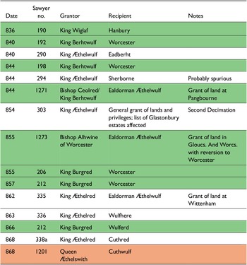
In contemporary narrative sources, Æthelwulf appears as a loyal subject of the West Saxon kings. However, the documentary evidence paints a different picture of his career. In fact, we see that Æthelwulf maintained concomitant obligations to both the Mercian and West Saxon kings between 836 and his death in 871. Æthelwulf was in receipt of three grants of land between 844 and 868. In 844, he received the Pangbourne grant from Berhtwulf of Mercia referred to above.Footnote 40 In 855, he received grants of land in Gloucestershire and Worcestershire from the Bishop of Worcester,Footnote 41 and then in 862 he received a grant of land at Wittenham from Æthelbehrt of Wessex.Footnote 42 In addition to these grants, he witnessed six Mercian charters between 836 and 866 and five West Saxon charters between 844 and 868.Footnote 43 These are listed in table 1.
Charters Involving Ealdorman Æthelwulf of Berkshire, 836–71
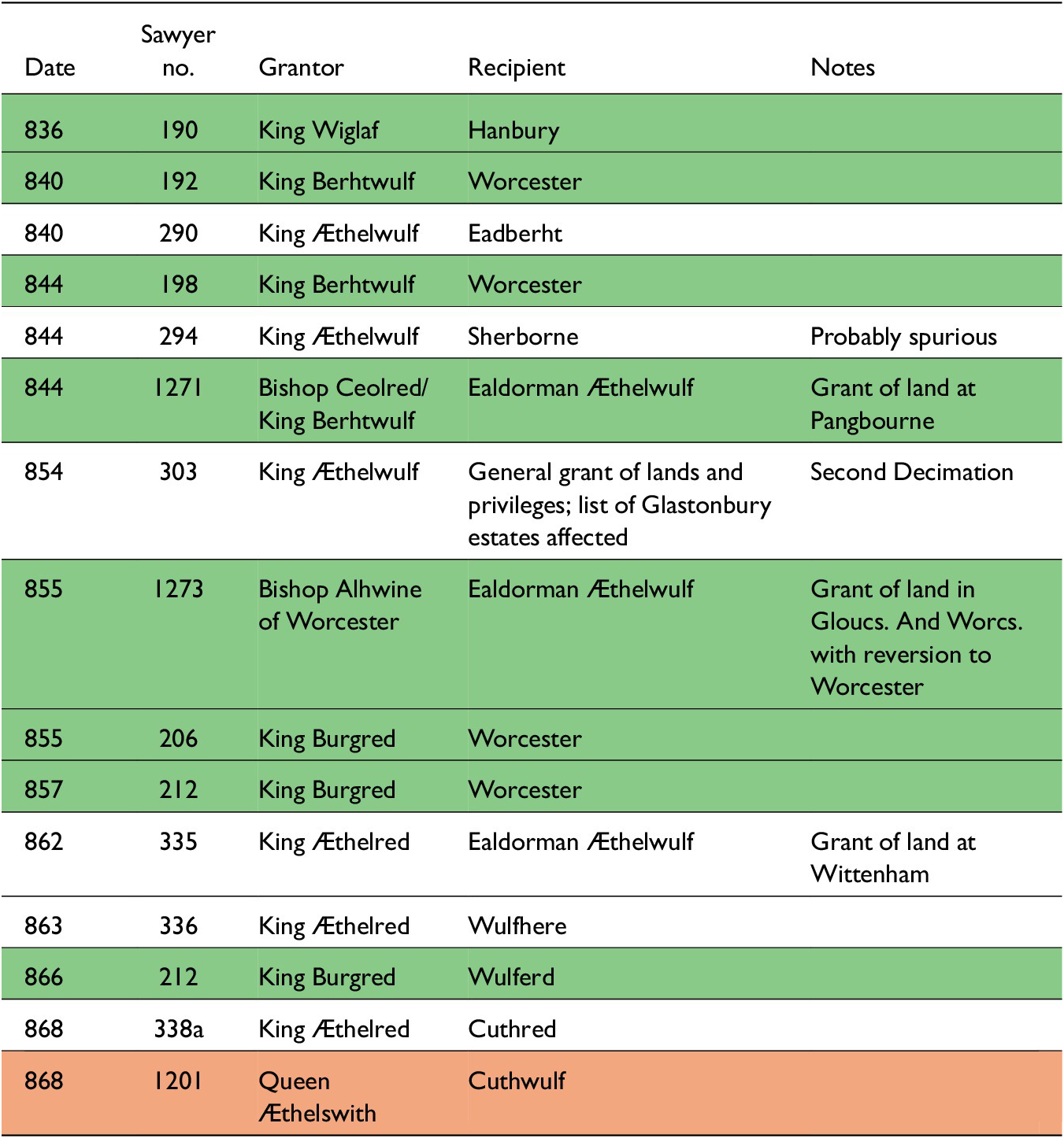
Table 1: Long description
The table contains five columns: Date, Sawyer no., Grantor, Recipient, and Notes.
* 836, 190, King Wiglaf, Hanbury.
* 840, 192, King Berhtwulf, Worcester.
* 840, 290, King Aethelwulf, Eadberht.
* 844, 198, King Berhtwulf, Worcester.
* 844, 294, King Aethelwulf, Sherborne, Probably spurious.
* 844, 1271, Bishop Ceolred or King Berhtwulf, Ealdorman Aethelwulf, Grant of land at Pangbourne.
* 854, 303, King Aethelwulf, General grant of lands and privileges; list of Glastonbury estates affected, Second Decimation.
* 855, 1273, Bishop Alhwine of Worcester, Ealdorman Aethelwulf, Grant of land in Gloucs. And Worcs. with reversion to Worcester.
* 855, 206, King Burgred, Worcester.
* 857, 212, King Burgred, Worcester.
* 862, 335, King Aethelred, Ealdorman Aethelwulf, Grant of land at Wittenham.
* 863, 336, King Aethelred, Wulfhere.
* 866, 212, King Burgred, Wulferd.
* 868, 338a, King Aethelred, Cuthred.
* 868, 1201, Queen Aethelswith, Cuthwulf.
Note: Mercian charters highlighted green, West Saxon charters unhighlighted. Charters pertaining to both kingdoms highlighted orange.
There is one other interesting detail. According to Æthelweard, in his late tenth-century Latin version of the Chronicle, after Æthelwulf was killed at Reading in 871, his body was taken ‘to the place called Northworthig, but in the Danish language Deoraby [Derby]’, suggesting kinship connections deep in Mercia.Footnote 44
Æthelwulf’s association with both courts throughout his career suggests a landscape in which royal authority was contested between the Mercians and the West Saxons well into the ninth century, in which someone such as Æthelwulf could play a significant role in mediating political control between the two kingdoms. After his death in 871, the region came to pass definitively into West Saxon hands, though this may have been drawn out over some decades. Indeed, it may be that the matter was not settled until 911, when the Chronicle reports that after Æthelred of Mercia’s death, Edward the Elder annexed London and Oxford along with all the lands belonging to them.Footnote 45
Throughout his career, Æthelwulf maintained links with both kingdoms. His continued obligations at the Mercian court did not preclude military service in Wessex and his obligations to the West Saxon kings did not prevent him from holding lands in Mercia. This should be a reminder that while Mercian-West Saxon relations up to 829 – the last recorded instance of hostilities between the two kingdoms – were marked by conflict, the later-ninth century is usually understood as a period of détente.Footnote 46 Æthelwulf’s career is a useful reminder that the frontier need not necessarily be hostile, but it did probably require some mediation and political deftness.
One way in which this frontier was mediated was through estates held by royal women in the region. To explore this, we must examine one other charter witnessed by Ealdorman Æthelwulf pertaining to Lockinge. This charter, S 1201, is from the Abingdon cartulary and is dated to 868.Footnote 47 The charter exists in two manuscripts. The C manuscript (London, British Library, Cotton Claudius C. IX) is dated to the twelfth century and the D manuscript (London, British Library, Cotton Claudius B. VI) dates to a century later.
The charter was issued by Æthelswith, wife of King Burgred of Mercia and the daughter of King Æthelwulf of Wessex.Footnote 48 In the charter, she grants fifteen hides at Lockinge in her own name as regina deo largiente merciorum and declares the grant to be of her own property ( mee proprie ), given with the consent of her councillors ( cum consensu et testimonio meorum seniorum ). The recipient is her minister Cuthwulf ( Cuþwulfo fideli meo ministro ), who is otherwise unattested, in exchange for 1500 solidi of silver and gold.
The charter was witnessed by both Æthelswith’s husband, King Burgred, and her brother King Æthelred of Wessex, though neither are mentioned elsewhere in the text, reinforcing that this was specifically a charter of Æthelswith in her own right. Other witnesses included Alfred and Oswald – both of whom attested as filius regis – Bishop Ealhferth of Winchester, and six men who attested as dux .Footnote 49
Three of these duces are notable. One was Earldorman Æthelwulf, discussed above. Another was Ealdorman Wulfhere of Wiltshire.Footnote 50 Wulfhere attested several West Saxon charters between 855 and 877/8, and he received grants from Æthelred of Wessex in respect to land at Buttermere and Æscmere in 863 and Winterbourne Monkton in 869, in addition to an undated grant at Hannington from Alfred (all in Wilts.).Footnote 51 However, a charter of Edward the Elder dated to 901 pertaining to land by the River Wylye refers to Wulfhere forfeiting his lands for ‘abandoning without permission his lord King Alfred and his country despite the oath he had sworn to the king and all his leading men.’Footnote 52 Crucially, the charter claims that Wulfhere was deprived of his inheritance by the judgment of the witan of the Gewisse (i.e. the West Saxons) and the Mercians.Footnote 53 Thus in 878, when Wulfhere was deposed, it was considered proper that the Mercian political community should have some say in the deposition of the Ealdorman of Wiltshire.Footnote 54 It is likely that Wulfhere was deposed after Guthrum’s attack on Chippenham at midwinter in 878 preceding Alfred’s sojourn in Athelney and the Ethandun campaign, hinting at the importance of ealdormen in frontier defence and the potentially disastrous consequences of lapses in military preparedness.Footnote 55
The third dux was Æthelred ‘Mucel’, who witnessed several Mercian charters between 836 and 868, but who is more notable for becoming Alfred of Wessex’s father-in-law when Alfred married his daughter Ealhswith in 868, the same year as the Lockinge charter.Footnote 56 Æthelred ‘Mucel’ also attested a charter of King Æthelred of Wessex at Dorchester (Dorset) in the same year.Footnote 57 We also know that in 868 Burgred sent envoys to Wessex to request military support from Æthelred and Alfred to assist with the siege of Nottingham.Footnote 58 It is plausible that the Lockinge charter was produced in the context of negotiations between the Mercians and West Saxons culminating in the marriage of Alfred to Ealhswith and a combined military campaign in Mercia.Footnote 59
If so, it would not be the first royal marriage between the Mercian and West Saxon houses tied to a military campaign. Æthelswith herself married Burgred at Chippenham in 853. The marriage was probably connected to Burgred’s request to King Æthelwulf for assistance with a military campaign against the Britons.Footnote 60 This expedition is framed by Asser as a demonstration of Æthelwulf’s strength and has often been taken as an example of the preeminent role of Wessex in the relationship between the two kingdoms in the mid-ninth century. However, this reading should be modified slightly considering the precise chronology of events in 851–3. In 851, a viking army sacked Canterbury before proceeding to London and putting Berhtwulf of Mercia to flight, potentially precipitating the end of his reign and the accession of Burgred in 852. Following the disturbances in Kent and the defeat of the Mercians, Æthelwulf of Wessex won a victory at Aclea, while Æthelwulf’s son Æthelstan – styled king in the Chronicle – defeated another host in a sea battle off Sandwich in Kent.Footnote 61 It may have been dawning on both Æthelwulf and the newly-crowned Burgred that the defence of Mercian-ruled London and West Saxon-ruled Kent was interdependent, and that mutual support was necessary. However, the results of the 853 campaigns were mixed. Both Asser and the Chronicle begin their account of 853 by describing the campaign against the Britons. Both texts then describe a battle fought on Thanet against a pagan host in which in which the ealdormen of Kent and Surrey were killed in the fighting and many men were slain and drowned.Footnote 62 It was only after this defeat that the marriage between Burgred and Æthelswith was concluded at Easter. It is plausible that the death of two ealdormen and many among their followings produced an acute sense of crisis in which a marriage to strengthen the growing alliance would seem mutually beneficial. The marriage, then, should probably not be read as a simple statement of inexorable West Saxon dominance.
The choice of Chippenham for the marriage of Æthelswith to Burgred should also be seen in this light. It has been suggested that the marriage was held at Chippenham, ‘in Wessex’, as a demonstration of Mercian subordination.Footnote 63 However, Chippenham should not be thought of as a villa regia in the heart of Wessex, but instead as a nodal point on the Mercian-West Saxon frontier, facing the Mercians in the north and west along the Fosse Way between Bath and Cirencester. Chippenham lies in the valley of the Avon, midway between the downlands of northeastern Wiltshire in the east and the Cotswolds in the west. It is fourteen kilometres south of Malmesbury, sixteen kilometres west of the frontier landscape in the vicinity of Avebury, and about five kilometres northwest of the east Wansdyke and the Roman road running from Mildenhall to Bath.Footnote 64 In 853, Burgred himself granted privileges to Worcester in exchange for land at Poulton and Eisey (both Wilts.), about twenty kilometres northeast of Chippenham; while as late as 864 Burgred and Æthelswith presided over a meeting of the Mercian witan at Bath, twenty kilometres southwest of Chippenham.
Æthelswith played a significant role in governance during her husband’s reign, reflecting both the relatively exalted status of Mercian queens compared to their West Saxon counterparts and the strength of the alliance between Mercia and Wessex in the late ninth century.Footnote 65 She attested every one of her husband’s charters. This was not necessarily unusual for Mercian queens. Æthelswith’s predecessor Sæthryth, for example, witnessed all of her husband Berhtwulf’s charters between 840 and 849, after which she disappears from the historical record.Footnote 66 More unusually, on at least one occasion Æthelswith made a grant in conjunction with Burgred at Bath in respect to Water Eaton (Oxon.) ( Ego Burhredus Deo omnipotenti donante et concedente rex Mercentium et Æthelswith regina mecum … dederimus … aliquam portionem terre proprii iuris nostri in loco ubi solicoli nominant Eaton iuxta flumine Cearwellan terram quinque cassatorum ad liberam potestatem omni rei sibi adabendum regis vel regina vel principes et omnium iuniorum meorum ).Footnote 67 The charter unambiguously claims that the grant was made jointly and would be free from obligation to either the king or the queen, perhaps providing an oblique reference to the queen maintaining a separate household.Footnote 68
Little is known of Æthelswith’s holdings besides Lockinge, but a fragment of a ‘stray’ charter of King Æthelwulf in the Christ Church archive makes reference to her in its bounds: ‘then to the rush brook, from there to the western fern wood/clearing, then to the estate that Queen Æthelswith and Ealdorman Æthelbald [i.e. Æthelswith’s brother, the future King Æthelbald, who attested several charters as dux between 850 and 855] obtained from King Æthelwulf.’Footnote 69 Unfortunately, the land in question cannot be identified but the dating clause states that the charter was done at Wilton on the second day of Easter in 854, the year after Æthelswith became queen of Mercia,Footnote 70 suggesting that Æthelswith continued to hold land in Wessex even after her marriage. She might even have held land jointly with her brother as Queen of Mercia. Æthelswith had agency in the political economy in her own right and could operate in both kingdoms.
As noted by Kelly, the formulae and language of the 868 Lockinge charter are consistent with other Mercian charters of Burgred’s reign. However, the witness list is mostly West Saxon. In the earlier D manuscript, King Æthelred of Wessex is the first to attest. His subscription is followed by that of the Bishop of Winchester. All the witnesses except two, Alhhard abbas and Ælðelferð minister , attest other charters of Æthelred, and there is little correspondence between the witness list of the D manuscript and the witnesses of Burgred’s charters, except for Æthelswith herself, Ealdorman Æthelwulf, and Mucel. Burgred does not attest until the very end of the document. However, in the later C manuscript, Burgred and Æthelswith attest after the West Saxon royal family. C’s witness list is truncated, ending after the attestation of Alhhard abbas with a curt et multi alii consenserunt . This could suggest that the scribe of the C manuscript found it unusual to see the attestation of the Mercian king at the end of the document and produced a more ‘sensible’ witness list in response, in which both kings are afforded a prominent place at the beginning of the list.
This is important because it has implications about the sequence leading to the production of the original text and the process of the diplomatic negotiations taking place. The Lockinge charter poses several intriguing but ultimately unanswerable questions: was the charter produced in the context of a meeting between the two kings, with S 1201 representing some business done on the side? Was the substance of the charter agreed upon and drafted in Mercia and then ratified by a West Saxon assembly as part of ongoing negotiations between the two kingdoms? Or was Æthelswith herself at the assembly, touring her estates and paying a visit to her brothers while serving as an agent of Mercian diplomacy? If so, perhaps the charter was drafted by a Mercian scribe in her entourage and sent at length to the Mercian court for final approval and the addition of Burgred’s attestation.
The ambiguity of the estate at Lockinge, located as it was on the Mercian-West Saxon frontier, reflects the ambiguous position of Æthelswith herself. A West Saxon by birth and a Mercian by marriage, she would serve as a representative of both kingdoms. Perhaps Lockinge served as a sort of ‘buffer’ in the region between competing interests while also serving as a symbol of the comity between Mercia and Wessex that characterised the later ninth century.
Directly adjacent to Lockinge is the estate of Wantage (fig. 2). Significantly, we know that Alfred bequeathed Wantage to his Mercian wife Eahlswith in his will.Footnote 71 Thus, in 868, the West Saxon wife of the Mercian king held Lockinge, and some thirty years later the Mercian wife of the West Saxon king held neighbouring Wantage. We may speculate as to whether Alfred’s mother Osburh was also connected to Wantage, because we know from Asser that Alfred himself was born on the estate in 848.Footnote 72 It should be remembered that Alfred was born only four years after Behrtwulf made his Pangbourne grant, only twenty-five kilometres southeast of Wantage.
At length, Wantage was bequeathed to Eadgifu by her son Eadred in his will, which may not have been implemented.Footnote 73 This marked the end of Wantage as a queenly estate, and after this Wantage passed to the king. In 956, Eadwig made a grant of five hides at Charlton, adjacent to the royal vill at Wantage, to his minister Wulfric, and in 982 Æthelred granted five hides of common land at the same Charlton to the minister Ælfgar.Footnote 74 In c. 997, the vill served as the site of a royal assembly, and it is where Æthelred’s third code was proclaimed.Footnote 75 There is some suggestion that there was a monastic context at Wantage according to the will of Wynflæd, and T.R.E. Wantage was held by King Edward and valued at a substantial £55 with twenty-one ploughs.Footnote 76
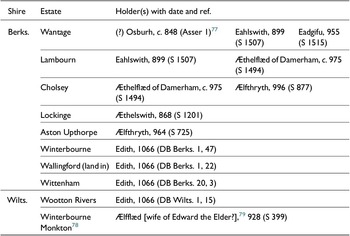
To round out the picture, several other estates were known to have been held on occasion by royal women on Æscesdune and in its environs after the formation of the tenth-century kingdom, as can be seen in table 2 and in the map provided at fig. 3.
Estates Held by Royal Women in the Berkshire, Lambourn and Marlborough Downs, c. 848–1066
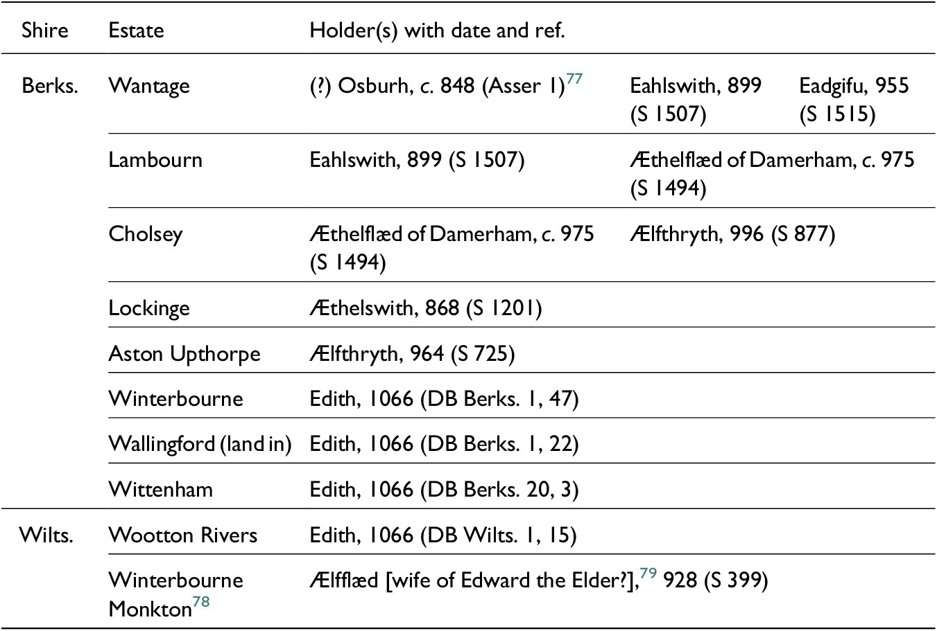
Table 2: Long description
The table is organized into three main columns: Shire, Estate, and Holder(s) with date and reference.
Under the Shire of Berks. (Berkshire):
* Wantage: Held by (?) Osburh, circa 848 (Asser 1); Eahlswith, 899 (S 1507); and Eadgifu, 955 (S 1515).
* Lambourn: Held by Eahlswith, 899 (S 1507) and Aethelflaed of Damerham, circa 975 (S 1494).
* Cholsey: Held by Aethelflaed of Damerham, circa 975 (S 1494) and Aelfthryth, 996 (S 877).
* Lockinge: Held by Aethelswith, 868 (S 1201).
* Aston Upthorpe: Held by Aelfthryth, 964 (S 725).
* Winterbourne: Held by Edith, 1066 (D B Berks. 1, 47).
* Wallingford (land in): Held by Edith, 1066 (D B Berks. 1, 22).
* Wittenham: Held by Edith, 1066 (D B Berks. 20, 3).
Under the Shire of Wilts. (Wiltshire):
* Wootton Rivers: Held by Edith, 1066 (D B Wilts. 1, 15).
* Winterbourne Monkton: Held by Aelfflaed (possibly the wife of Edward the Elder), 928 (S 399).
Estates and Holdings of Royal Women in the Berkshire, Lambourn and Marlborough Downs, c. 868–1066.
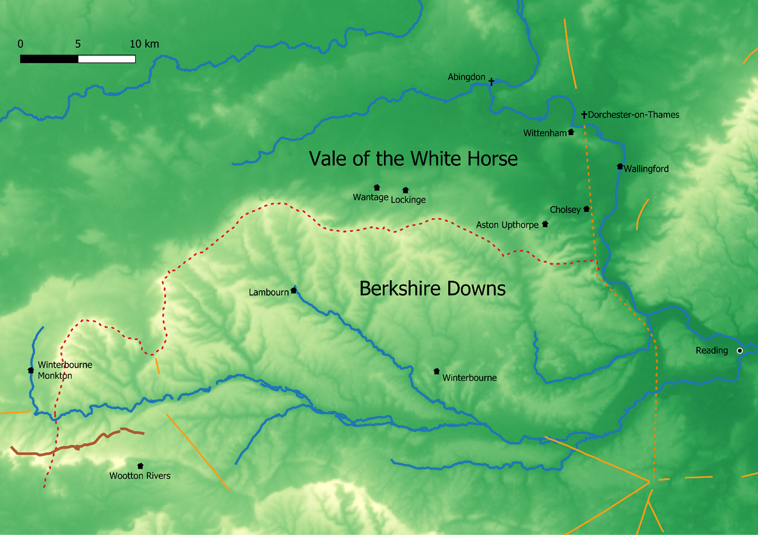
Figure 3: Long description
A topographical map using green and yellow shading to indicate elevation. In the Northwest corner is a scale bar representing 0 to 10 kilometers.
North of the central ridge is the Vale of the White Horse, featuring the settlements of Abingdon, Dorchester-on-Thames, Wittenham, Wantage, and Lockinge. A blue river line flows through this area.
In the center, the Berkshire Downs are marked by a prominent ridge. A red dotted line follows the northern edge of this ridge, passing through Aston Upthorpe and Cholsey.
To the West and Southwest, the Lambourn Downs contain the settlements of Lambourn, Winterbourne Monkton, and Winterbourne. A blue river flows Southeast from Lambourn.
In the East, the settlements of Wallingford and Reading are located near a major river junction.
In the South, Wootton Rivers is marked. Several orange lines intersect in the Southeast corner, suggesting historical boundaries or routes. The map uses black house icons for settlements and crosses for ecclesiastical sites like Abingdon and Dorchester-on-Thames.
Wantage, Lambourn and Cholsey were held by multiple royal women between the ninth and eleventh centuries, possibly suggesting special importance. Thus, if in the ninth century the disposition of Lockinge and Wantage served to help mediate the Mercian-West Saxon frontier, in the tenth and eleventh centuries, the continued association of the region with women of the royal house may have served to strengthen connections between the royal dynasty and a hitherto peripheral landscape that had only recently come under royal control, thereby making use of the landscape and the king’s powers of patronage and largesse while keeping the region within the royal interest.
What does in mean for an estate to be ‘queenly’ in early medieval England? Royal women held land in a variety of ways: some land was that of their paternal kin,Footnote 80 some was held by book and could be alienated, and some seems to have been granted to a royal lady, either as consort or in their dowagerhood, with the intention that the land would revert to the crown. Indeed, several of the estates in question in the Berkshire Downs were held by the king T.R.E. Footnote 81 However, it should be noted that, apart from Queen Edith, for whom we have the evidence of Domesday, the picture is unavoidably incomplete. Royal women must have held estates – perhaps a considerable number – for which no charter or will survives. Furthermore, there may have been a considerable amount of land held by queens, consorts and dowagers that had never been booked. Their revenues were not only derived from landed estates. Queen Edith, for instance, enjoyed various commercial rights in certain places, such as to wool in Cirencester.Footnote 82
Often, when historians discuss the ‘queen’s demesne’ in Anglo-Saxon England, they are referring to clustered estates held in Rutland and Leicestershire which were associated with Emma and Edith in the eleventh century.Footnote 83 It has occasionally been argued that the Rutland estates may have fossilized the arrangements made for Mercian queens before the Cerdicing conquest in the tenth century.Footnote 84 However, it is probable that there were other estates, or groups of estates, that were traditionally associated with the women of the royal dynasty.Footnote 85 Thus, while to speak in terms of ‘demesne’ land may be to ask too much of sparse evidence, much of the land held by Edith had demonstrable links with earlier English queens.
Lands held by queens were enmeshed with other royal landholdings, and the need to provide for the queen, dowagers, concubines and former wives – while also allowing for reversion of estates to the crown – meant that the holdings of queens and other royal women were never static. Queenly landholding was a means of communicating royal power in the expanding tenth-century realm, as lands given as dowry were incorporated into royal lands. There was a significant degree of symbiosis between queens’ lands and the church, as queenly lands were used for the endowment and provisioning of royally connected minsters in the tenth and eleventh centuries, as shall be discussed below regarding Cholsey.Footnote 86 In practical terms, it may be that queens maintained an interest in monastic houses as sources of revenue. As Stafford writes, in 1002 Wherwell minster claimed that Ælfthryth had appropriated sixty hides belonging to the minster at Æthelingadene for her own use, which the minster sought to have restored upon Ælfthryth’s death.Footnote 87 Finally, there was a broader strategic element to queenly landholding related to the defence and organization of the realm. In particular, Stafford notes the importance of Edith’s chain of great estates beginning at Finedon in Northamptonshire, and running north through Leicestershire, Rutland and Lincolnshire; she describes these estates, strung along the Roman road of Ermine Street, as ‘the keys to the north.’Footnote 88
It is reasonable to wonder the extent to which the association of certain estates with queens and royal women mattered ‘on the ground’. The evidence here is limited, but it is possible to make some suggestions. Queens took men into their service, inspired loyalty, and could channel largesse and patronage between local districts with which they were associated and the royal court. In the Vita Sancti Wilfrithi , the young Deiran nobleman Wilfrid was recommended to Queen Eanflæd – herself the daughter of King Edwin of Deira – by members of his father’s household. Eanflæd in turn recommended Wilfrid to her Bernician husband, Oswiu. At length, Eanflæd introduced Wilfrid to her cousin, King Eorcenberht of Kent. As a representative of the remnants of the Deiran royal house, Eanflæd could effectively advocate for the local Deiran nobility and bring them into contact with the courts of her husband and cousin, thereby leveraging both vertical and horizontal connections and serving as an interface between these three networks.Footnote 89
Thegns also took service with queens. For example, Bede wrote that the thegn Imma, who was captured by the Mercians at the Battle of the Trent in 679, had been in the service of Queen Æthelthryth ( reginae minister ), who had been married to Ecgfrith of Northumbria. Ultimately, King Hlothere of Kent ransomed Imma in recognition of Imma’s time in the service of Æthelthryth, Hlothere’s maternal aunt.Footnote 90
In the eleventh century, men could hold land of the queen and there are some people referred to in Domesday as ‘Queen’s Men’. North Mymms (Herts.), for example, was held T.R.E. by ‘three thegns, Queen Edith’s men’.Footnote 91 Other examples include Modig (Thurleigh, Beds.), Alwin the Hunter (Cashio, Herts.), Algar (Sharnbrook, Beds.), Alfgeat (Bradwell, Bucks.), Ælfric (Wolverton, Bucks.), and Siric (Lillingstone, Bucks.).Footnote 92 Such men might be expected to represent Edith’s interests – both formally and informally – in local courts and assemblies, forming a tangible link between the royal family and local landholders.
In some places, queens appointed reeves to oversee their interests. In Eardisland (Heref.), it was customary for the local reeve to give his domina – either Edith or perhaps the wife of Earl Morcar in this case – eighteen ora for her pleasure and ten solidi to her steward and other officers.Footnote 93 The entry is interesting as it suggests that the queen or another great lady might be expected to visit her estates with members of her household and that local officials should anticipate her arrival. The customary act of giving the lady eighteen ora was performed because of her presence, solidifying the connection between the lady and the estate and its inhabitants. On at least one occasion, the appointment of a reeve had disastrous consequences. In 1003, the Chronicle reported that ‘Exeter was stormed on account of the French ceorl Hugh, whom the queen had appointed as her reeve’.Footnote 94
To bring this back to Lockinge and Queen Æthelswith, there is no reason to think that Cuthwulf’s service ended with the Lockinge charter, and he may have continued to serve Æthelswith in the district after the grant was made. The famous ring of Æthelswith, a nielloed Trewhiddle-style gold ring bearing the Agnus Dei between a monogrammed inscription A Đ within a quatrefoil on the face and the inscription +EAĐELSVIĐ REGINA upon the band is also notable. It is possible that the ring was meant as gift or token from the queen to one of her retainers, serving as a possible artefact of the social connection between a queen and those in her service.Footnote 95 This reminds us that Æthelswith would maintain her own household and retinue and she could inspire loyalty, give gifts and treasure, dispose of land, and demand service from those who owed it to her.Footnote 96
Thus far, Lockinge has been discussed in terms of mediation, but estates held by royal women could also memorialize victory and triumph. English queens were not only peacemakers; there was also a role for the celebration of dynastic success. In his will, Alfred left Edington, the site of his great victory over Guthrum in 878, to his wife Ealhswith.Footnote 97 The Berkshire Downs were also remembered in the Anglo-Saxon Chronicle as a place associated with warfare. The Chronicle records no less than eight entries containing battles or instances of warfare between s.a. 556 and 1010 (some of which are presumably legendary), marking the densest geographical concentration of conflict recorded in pre-Conquest sources.Footnote 98 Therefore, when Alfred willed Wantage and Lambourn to his wife, it may be that this also served to commemorate military victories in the Downs at Englefield and Ashdown in 871. Meanwhile, the association of estates on the downs with Ealhswith in Alfred’s will may have helped reconcile the Mercians – and perhaps in particular the men of Berkshire, left bereft of their lord Æthelwulf – to the rule of Alfred and Ealhswith’s son, Edward.
Of course, the assertion of royal authority through women of the dynasty was not always done in the spirit of reconciliation. In some instances, the practice may have been meant to legitimise conquest. The minster of Cookham, lying upon a bend on the south bank of the Thames on the modern border of Berkshire and Buckinghamshire was intensely contested between the West Saxons and Mercians in the eighth century. At the Council of Clofesho in 798, it was related that Æthelbald of Mercia had given Cookham and its appurtenances to Canterbury. After the death of Archbishop Cuthbert in 760, Cookham’s muniments were stolen and delivered into the hands of Cynewulf of Wessex (r. 757–786), and that Cynewulf ‘took over for his own uses the monastery with all things belonging to it’. At length, Offa of Mercia seized the minster of Cookham after defeating the West Saxons in battle at Bensington (Benson, Oxon.), lying upon the north bank of Thames directly across the river from Wallingford. After Offa’s death the minster was held controversially by his widow Cynethryth.Footnote 99 Vanessa King has recently suggested that Cynethryth herself may have been a daughter of Cynewulf of Wessex, adding the possibility that her tenure at Cookham was patrimonial.Footnote 100 If so, her family connections may have helped legitimise Offa’s seizure of the minster and the expansion of Mercian power into the region. This may have buttressed more prosaic concerns. Recent excavation around the Cookham waterfront points to a significant degree of production, suggesting an economic rationale for controlling the Middle Valley of the Thames, perhaps with the minster serving as a nodal point in a trade network linking the Midlands and London via the Thames Valley.Footnote 101
Similarly, Coenwulf of Mercia’s daughter Cwoenthryth’s tenure as abbess of Minster-in-Thanet and Reculver was related to the consolidation of Mercian power in Kent, and the liminal context of Thanet should be recognized here.Footnote 102 While not on a landward frontier, Thanet had a reputation as a place for interface with strangers and newcomers. According to the ninth-century Historia Brittonum , the Saxons were first granted land on Thanet in return for military service, while the Chronicle claimed that Hengist and Horsa made landfall in Ebbsfleet on Thanet.Footnote 103 Before being welcomed into the Kentish interior, the Augustinian mission was similarly confined to Thanet.Footnote 104 Meanwhile, the BCDE MSS of the Chronicle agree with Æthelweard that Scandinavians first overwintered on Thanet.Footnote 105
After the collapse of Mercian hegemony in the 820s, the tradition of imperial royal abbesses fell into abeyance with the resolution of Cwoenthryth’s dispute with the archbishop of Canterbury in 827.Footnote 106 Perhaps the secular tenure described above for Lockinge and Wantage reflects a reaction against the politics of the previous generation – a development that would be similar in practice but markedly different in form, perhaps providing a less ostentatious and controversial mode that better reflected the political climate of the later ninth century.
In the mid-tenth century, however, enthusiasm for monastic reform took root among the aristocracy and royal family, leading to the foundation or re-foundation of many houses with royal connections.Footnote 107 In the Berkshire Downs, we see this at Cholsey. Located on the eastern fringe of the downland, nestled between Brightwell Barrow and the Wittenham Clumps in the north, Blewburton Hillfort in the west, and Lowbury Hill to the south-southwest. The fortified burh of Wallingford lay four kilometres north-northeast, with the Thames a kilometre and a half due east. Cholsey is eleven and a half kilometres north of the Bradfield-Englefield-Streatley cluster described above (fig. 2). The estate was known to be held by Æthelflæd of Damerham and subsequently by Ælfthryth, the mother of Æthelred II.Footnote 108 Ælfthryth provided the endowment for a reformed minster at Cholsey in 986, which was one of the most prominent foundations of Æthelred’s reign.Footnote 109 It may even be that the foundation of Cholsey was meant to serve as a place of reconciliation and expiation following the murder of Edward the Martyr in 978.Footnote 110
However, even if Cholsey was meant to be a place of unity, it is hard to see the minster as symbolic of anything other than the wreckage of Æthelred’s kingship in the first decade of the eleventh century. In 1006, a raiding army marched through Cholsey before progressing across the Berkshire Downs and carrying their plunder right before the gates of Winchester itself before returning to their ships. It is worth quoting the passage at length:
When winter approached, the fyrd [i.e. the ‘English’] went home, and the here [i.e. the ‘Danes’] then came after Martinmas to its sanctuary ( friðstole ), the Isle of Wight, and procured for themselves everywhere whatever they needed; and then towards Christmas they betook themselves to the provender ( feorm ) awaiting them, out through Hampshire into Berkshire to Reading; and always they observed their ancient custom, lighting their beacons ( herebeacen ) as they went. They then turned to Wallingford and burnt it all, and were one night at Cholsey, and then turned along Æscesdune to Cwichelmeshlæwe, and waited there for what had proudly been threatened, for it had often been said that if they went to Cwichelmeshlæwe, they would never reach the sea. They then went home another way. The fyrd was then gathered at the Kennet, and they joined battle there, and at once they [i.e. the here ] put that troop to flight, and afterwards carried their booty to the sea. There the people of Winchester could see that army, proud and undaunted, when they went past their gate to the sea, and fetched themselves food and treasure from more than fifty miles from the sea.Footnote 111
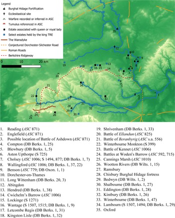
Cholsey is never mentioned again after this, and it is likely that the minster was destroyed.Footnote 112 The route that the army took is notable. By progressing north from the Isle of Wight to Reading they would surely have taken the Roman road in evidence at Streatley, between Bradfield/Englefield and Cholsey, as they lit their beacons. From Reading, they attacked and destroyed the Burghal Hidage fortress (and later Domesday borough) of Wallingford.Footnote 113 At Cholsey, they would have ascended the Berkshire Downs to come to the shire assembly place at Cwichelmeshlæwe. The chronicler gives the barrow an almost numinous quality as a place of exclusion and implies that the coming of the enemy to this barrow – associated as it was with the eponymous Cwichelm – would mark a fateful breach of the king’s peace. From there, the army must have progressed along Æscesdune by means of the Ridgeway that runs along the scarp of the Downs. Langlands has suggested that the Roman road from Silchester to Bath was not in use during the early medieval period, and if this was indeed the case then the Ridgeway would have been the principal east-west route in the region.Footnote 114 The army would have passed above Lockinge and Wantage, past the battlefields memorialised in the Anglo-Saxon Chronicle at Ellandun and Beranbyrig, past significant royal estates at Letcombe Regis,Footnote 115 Kingston Lisle,Footnote 116 Lambourn,Footnote 117 and Shrivenham before turning south.Footnote 118 They routed the fyrd that assembled against them æt Cynetan, which Williams has linked to Overton Hill, just north of where the Ridgeway fords the Kennet, and then could progress through the assemblage of theophoric place-names south of the river: Woden’s Gate, Woden’s Dyke, and Woden’s Barrow, the latter being the site of two battles recorded in the Chronicle. Footnote 119 From there the army came upon the Vale of Pewsey, referenced in both the will of Alfred and a 940 charter of Edmund.Footnote 120 If then the army chose to march east, they would march through Savernake Forest before coming to the royal estates at Bedwyn and Shalbourne and the Burghal Hidage fortress of Chisbury,Footnote 121 before joining the Roman Cirencester-Winchester road and returning to their ships.Footnote 122 The progress of the here through so royal a landscape as they ‘fetched themselves food and treasure’ must have been a potent signal of Æthelred’s failure as a patron and protector, as the minster closely associated with his mother and his venerated half-brother was destroyed. The army progressed through a landscape that was dense with royal significance, perhaps appropriating a leg of a royal progress across the Downs, thereby delegitimising Æthelred’s kingship in the eyes of a bitter chronicler. We see, therefore, how even after the formation of the tenth-century kingdom, this former frontier zone remained a contested landscape that served as a potent stage for both the demonstration and subversion of kingship (fig. 4).
The Royal Landscape of the Berkshire, Lambourn and Marlborough Downs, c. 1006.
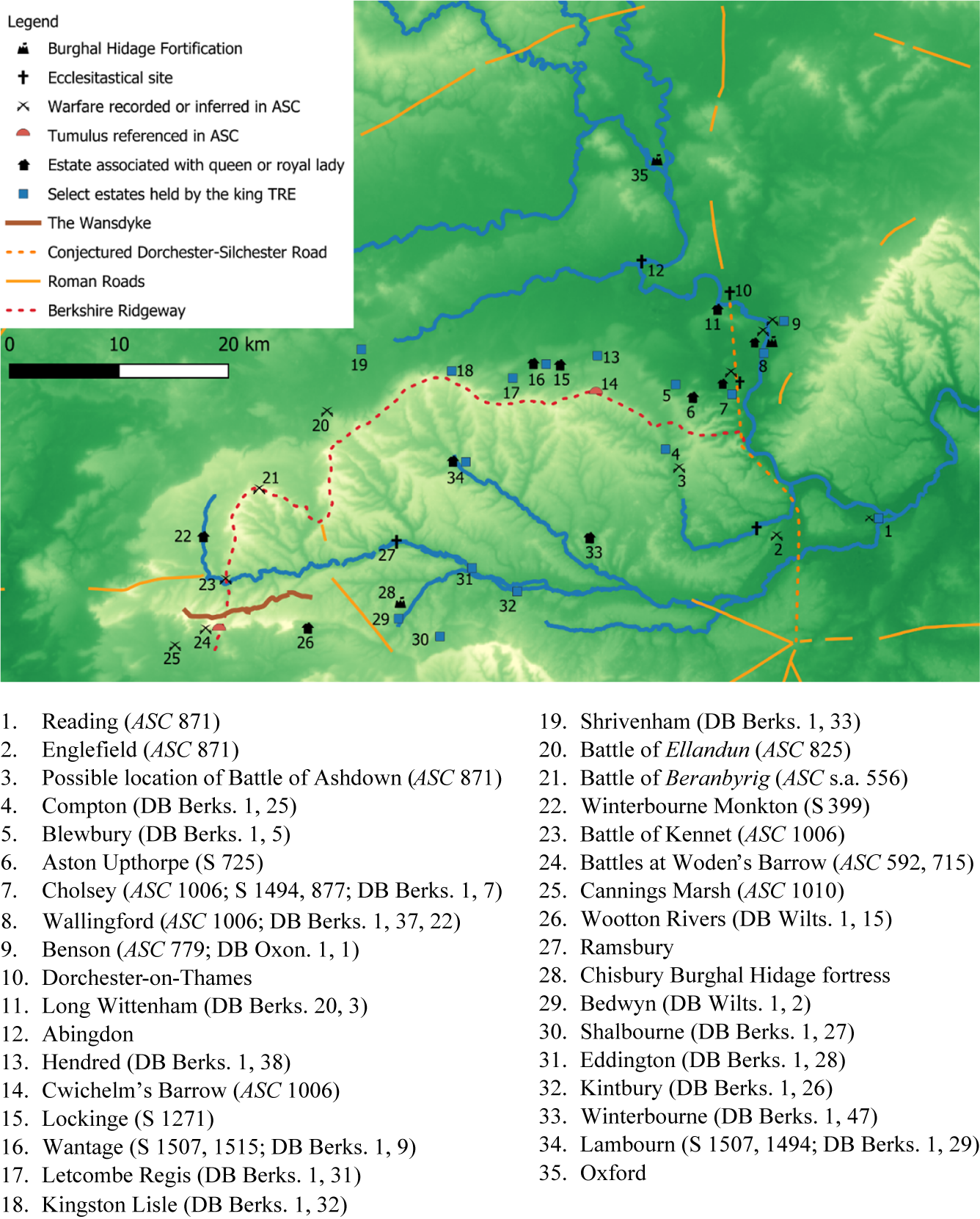
Figure 4: Long description
A topographical map uses green and white shading to indicate elevation. A legend in the Northwest corner identifies symbols for Burghal Hidage Fortifications, Ecclesiastical sites, Warfare recorded or inferred in A S C, Tumulus referenced in A S C, Estates associated with a queen or royal lady, and Select estates held by the king T R E. Linear features include The Wansdyke, Conjectured Dorchester-Silchester Road, Roman Roads, and the Berkshire Ridgeway. A scale bar indicates 0 to 20 kilometers.
Key features distributed across the map include.
* Waterways: Blue lines representing rivers flow generally from the Northwest toward the Southeast.
* Northern Region: Sites 35, 12, 10, and 11 are clustered near the river in the North and Northeast.
* Central Belt: A dense line of sites numbered 13 through 19 follows the red dashed Berkshire Ridgeway running West to East. Sites 5, 6, 7, 8, and 9 are concentrated in the East where the Ridgeway meets a North-South orange dashed conjectured road.
* Southern Region: Sites 20 through 34 are spread across the lower half. The Wansdyke is a solid brown line in the Southwest near sites 23 and 24. Warfare symbols marked with an X are concentrated in the Southwest near sites 24 and 25, and in the East near site 9.
* Royal Estates: Black house icons representing queen’s estates are found at sites 35, 16, 15, 6, 7, 34, 33, 22, and 26. Blue square icons for king’s estates are numerous, including sites 19, 18, 17, 13, 5, 8, 4, 31, 32, 30, and 29.
Thus, while the use of the landscape of the Berkshire Downs was not static, there is evidence for a continuity in the way the landscape was perceived. Between the seventh and ninth centuries, the district marked a frontier between Mercia and Wessex, and the downlands of Berkshire must be seen in conjunction with the better-studied landscape of the Marlborough Downs as part of a broad frontier zone that ranged from the Thames in the east to Bath in the west. The frontier was managed in a variety of different ways by royal agents and regional intermediaries. In the late seventh and early eighth centuries, for example, the minster of Bradfield sought to chart a course for itself between the looming powers of Ine of Wessex and Æthelred of Mercia. The transfer of Dorchester-on-Thames to the Mercian diocese may have been particularly important in this regard, bringing the region under the aegis of the Mercian bishops. Meanwhile, entries of the Anglo-Saxon Chronicle tie the landscape to Cuthred and Cwichelm and worked to weave the region into the narrative of the West Saxon dynasty. In the third quarter of the ninth century, Ealdorman Æthelwulf of Berkshire also found himself navigating between both courts with apparent success, and he was able to maintain his position despite concomitant obligations to both the West Saxon and Mercian kings.
Æthelwulf’s career reflected the increasingly cordial relations between Mercia and Wessex that marked the mid-ninth century. This is a useful reminder that while historians often focus on frontiers as spaces of conflict, they were also spaces of mediation. One way that the frontier zone was mediated during this crucial transitional period may have been through estates held by royal women in Lockinge and Wantage and the influential position held by Æthelswith of Mercia. The multifaceted roles of royal women so familiar to the student of Old English literature – peace-weaver, dynastic representative, keeper of family memory – seems in this case to be mirrored in the landscape as the West Saxon dynasty negotiated control of the region with the Mercians and eventually asserted its authority in the downlands of northern Wessex in the late ninth and early tenth centuries.
A potential association between royal women and liminal landscapes may represent a development of practices that had their origins in the tradition of female monasticism that so marked the dynastic politics of England between the beginning of the conversion period and the mid-ninth century, and it is possible that estates such as Wantage and Lockinge fulfilled a similar social function to, say, Cookham while proving less controversial and antagonistic in a more conciliatory but still potentially delicate political landscape.
Even after the incorporation of the Downs into the unitary English kingdom of the tenth and eleventh centuries, there remained an association between the region and women of the royal house, perhaps to consolidate dynastic authority in the district. Associating estates in the Downs with ladies of the royal dynasty helped bind the landscape to the royal family while utilising the king’s powers of patronage, largesse and protection, all while keeping land within the royal interest, as estates held by queens and dowagers were flexibly integrated into a densely woven royal landscape encompassing royal vills, assembly places, appropriated prehistoric monuments, battlefields memorialised in the Anglo-Saxon Chronicle, and reformed minsters. It is suggested here that the Berkshire Downs transformed over the tenth century from a contested frontier into a core royal zone, and it may be that the Berkshire Ridgeway formed a leg of a royal progress. This created a landscape that was ideologically charged and deeply resonant. In the ninth and tenth centuries, ladies of royal family helped mediate this transformation. This is a useful reminder that everything has a landscape context, and the provision for queens, widows and dowagers could have a political and ideological valence that was useful to a resourceful king, and which was represented in the landscape itself.
Acknowledgements
I am grateful to Professor Alex Woolf for comments and suggestions on an earlier draft; all errors of fact and interpretation remain my own.

 Open access

