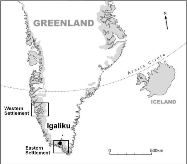
Greenland in its northwest Atlantic context. The location of Igaliku (Garðar) is marked.

Introduction
The image of Norse Greenland as a marginal community of subsistence farmers whose eventual failure in the fifteenth century reflected an inability, or unwillingness, to change in the face of climate change and increased environmental stress has become something of a topos (cf. Reference DiamondDiamond 2005). Evidence of increased erosion as a result of grazing pressure after the introduction of sheep, goats and cattle is widespread in southwest Greenland (e.g. Reference FredskildFredskild 1992), and some details of the fortunes of individual farms have been presented from palaeoecological records (e.g. Reference MainlandMainland 2006; Panagiotakopulu et al. 2007).
Contrasts have been drawn between the more northerly Western Settlement (Figure 1), as a place where hunters farmed, and the Eastern Settlement, whose farmers appear more akin to those of contemporary Iceland, except for the virtual absence of fish as part of their diet or economy (cf. Reference BerglundBerglund 1986). An econocentric view (Dugmore et al. 2007) is that Norse Greenland existed as an outpost of Iceland occupied to secure access to élite trade materials, principally walrus ivory, skins and furs, for medieval Europe, and that collapse in Greenland was a consequence of the re-orientation of supply and the development of alternative materials.
Norse ruins at Garðar/Igaliku. The cathedral is in the foreground and a slab marks a bishop's grave. The lintelled building in the background is the so-called 'Tithe Barn'.

Whatever the causes of abandonment, Norse Greenlandic farmers were not passive bystanders when confronted with natural or economic difficulties. They deliberately modified their landscapes in an effort to increase hay yields for their dairy stock especially. Reference SchwegerSchweger (1998) has suggested that the geoarchaeological evidence for manuring at the site of Gården under Sandet in the Western settlement amounted to the development of a plaggen soil and there is isotope evidence for selective manuring in the Eastern Settlement (Commisso & Nelson 2007). Ingstad (1966; see Reference ArneborgArneborg 2005 for more examples) had drawn attention to evidence for water management at the site of Garðar, the modern Igaliku (Figure 1), and location of the bishop's farm and cathedral (Figure 2) in the Eastern Settlement. New evidence from Garðar implies an integrated system of manuring and irrigation of hayfields which must have required a significant annual input of labour in order to sustain it.
Garðar/Igaliku photographed in August 2005. The ecclesiastical buildings are located to the left of the blue hut. Upcast from the cutting of drainage ditches (visible to the right of the hut) marks the position of open sections from which palaeoenvironmental samples were taken.

Garðar
In 2005, farmers at Igaliku cut a series of drainage ditches in the pasture beside the main farm complex (Figure 3). These exposed a sequence of organic deposits, rich in artefactual material and other debris overlying a gently undulating surface of sands and silts and sealed by a fibrous peat (Figure 4). The sharp basal boundary between the artefact-rich layer and basal sands/silts probably reflects the stripping of turves for the construction of farm buildings (cf. Reference KroghKrogh 1967), and the beginning of organic sedimentation (dating prior to cal AD 1040-1250) indicates a major change in the depositional environment.
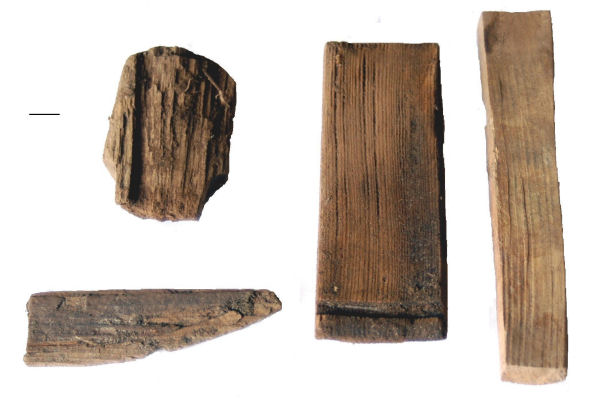
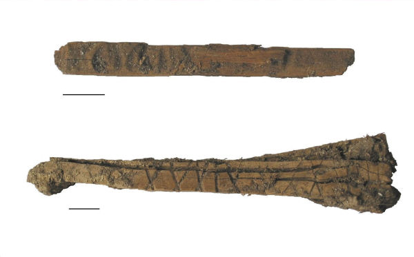
As well as fragments of coopered bowls (Figure 5), two notched tally sticks were recovered from the upcast from the ditches (Figure 6). One is the standard merchants' tally, familiar from Bergen (Reference GrandellGrandell 1988), the other, with its carefully carved groups of notches, is matched by similar examples from Sandnes (Kilærsavík) in the Western Settlement (Reference RoussellRoussell 1936) and may have functioned as a rosary (Ólafsson, pers. comm.).
Ditch section at Garðar/Igaliku showing poorly sorted grey-brown sands and silts with scattered stones (i) overlain by a dark brown humified and clay-rich peat containing abundant cultural material (a plaggen soil) (ii), and sealed by brown fibrous peat lacking in artefactual debris (iii). Calibration of AMS radiocarbon dates on Montia fontana seeds using Calib Rev 5.0 produces 2σ ranges of cal AD 1040-1250 (lower sample) and cal AD 1290-1400 (upper sample).

Wooden artefacts recovered from the upcast of the ditch section: (bottom left) basal section and (top left) broken roughout for a handle loop; (centre and right) staves (Scale bar = 10mm).

The palaeoecological data (insects and pollen sampled from the drainage ditch) include a natural assemblage suggesting a wet eutrophic peaty field with small pools mixed with an indoor component rich in human and animal ectoparasites (essentially a stored-hay fly and beetle fauna). It appears that waste materials from the farm, including the byres - the bishop's stalls for about 100 cattle are out of all proportion to anything else in Greenland (Reference McGovernMcGovern 1992) - were being liberally spread across the hayfield to create a plaggen soil. This, combined with the evidence for wetlands in an area which might otherwise be prone to drought, implies a management of resources similar to the English use of water meadows, although considerably earlier than any known example there (cf. Reference BetteyBettey 1999), and Scandinavian sources (e.g. Emanuelsson & Moller 1990) imply that examples of these systems in Norse homelands may derive from English prototypes.
Saga and Icelandic law code evidence (Havarðs saga ch. 14; Grágás K187), however, indicates the use of irrigation on hayfields during the medieval period and the tradition seems also to have been maintained in the similarly drought-prone inland area of Gudbrandsdal in central Norway (Michelson 1987). It is perhaps not without significance that Greenland's first bishop, Arnald, sent out from Lund in AD 1124, became bishop of Hamar (less than 100km south of Gudbrandsdal) upon his return to Norway in 1152.
Tally stick fragments from the ditch upcast: (top) possible rosary; (bottom) standard merchants' tally stick (Scale bar = 10mm).

Conclusion
The extensive re-modelling of the landscape around Garðar to utilise both midden and water supply would have required the annual articulation of considerable labour. From the dating evidence, it seems that the system was maintained until the estate was finally abandoned in the fifteenth century - the cessation of manuring (cal AD 1290-1400) is a very abrupt horizon. The power of successive bishops and their bailiffs over generations of 'independent people' (sensu Reference LaxnessLaxness 1946) is evident, and would support the hypothesis that final desertion reflects a group decision implemented by the See.
The abandonment of Norse Greenland essentially fossilised a medieval managed landscape with few parallels in Northern Europe. Whilst the reintroduction of sheep farming since the late eighteenth century has caused significant damage to the remains, the evidence for manipulation of resources by the Bishop's men adds to the site's importance and strengthens the proposal to give the region World Heritage status (>http://whc.unesco.org/en/tentativelists/1781/).
Acknowledgements
The Leverhulme Trust is warmly thanked for financial support. Georg Nyegaard, previously director of the Qoqortoq Museum, now of the Grønlands Landsmuseum, dealt with permissions and gave advice concerning artefacts. The interest and comments of Jette Arneborg and Guðmundur Ólafsson are gratefully acknowledged. The people of Igaliku showed considerable forbearance in allowing us to probe into their ditches.