Introduction
In the early 1970s, Professor A.R. Khan of Karachi University conducted the first geoarchaeological survey of the coast of Las Bela (Reference Khan and KhanKhan 1979a). The results (Reference Khan and KhanKhan 1979b) suggested that the coastal areas of Las Bela and southern Sindh have great archaeological potential because of their geographical location and morphological characteristics, as is also reported in the chronicles of the Classical authors, especially Arrian (see for example Reference MccrindleMcCrindle 1879). In 2011, a joint programme of archaeological surveys was initiated by the universities of Ca' Foscari (Venice) and Balochistan (Quetta). Its principal scope was to locate prehistoric shell middens along the shores of Lake Siranda, to AMS-date samples of mangrove gastropods from any new sites, to contribute to the study of the Neolithic peopling of the region and their eventual seafaring along the northern coast of the Arabian Sea and, finally, to interpret the geomorphological variations that took place in the territory of Las Bela since the start of the Holocene.
Geographical setting
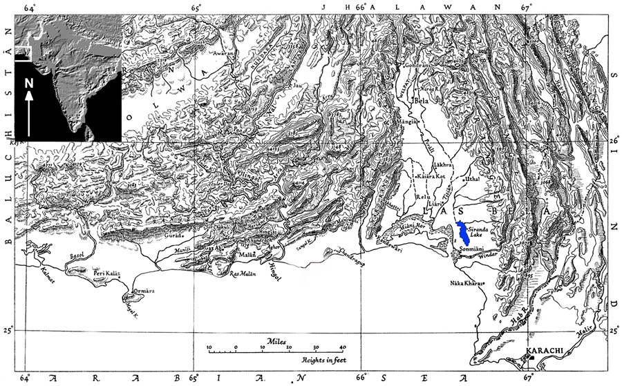
Location of Lake Siranda (blue spot) in Las Bela province of Balochistan, Pakistan (from Reference SteinStein 1943: 195, with variations).

The first geological account of the landscape surrounding Lake Siranda was written by R.E. Snead (1966: 58): "a desert depression with no normal outlet to the sea". The lake stretches from north to south between the Holocene dunes of the Sonmiani Hills in the west, and the Pleistocene sand plain that extends to the east (Snead & Frishman 1968), while in the south it is delimited by the Khurkera plain, formed by the silting of the Winder River flowing from the Pab Range (Reference PithawallaPithawalla 1952: 33).
Lake Siranda, some 14km long and 3km wide, and only 0.30–0.45m above the present sea level, is located in the southernmost part of Las Bela Valley (Figure 1) (Reference SneadSnead 1969). Although fed by summer monsoon rains draining into the basin mainly by the Watto River—an easternmost branch of the Porali River (Reference SteinStein 1943: 198)—today the lake is often dry, depending on the seasonal precipitation (Reference AkhtarAkhtar 2011). According to data from the 1950s, its maximum depth was 1.5m in the winter and 3m in the summer (Reference PithawallaPithawalla 1952: 33).
In one of his papers, Snead reports scatters of marine and mangrove shells, both along the eastern shores of the lake and within its bed (Reference SneadSnead 1966: fig. 15), suggesting that the lake, formed by the recession of the sea (Reference MinchinMinchin 1907: 10), "was lower and functioned as a tidal lagoon in the not-too-distant past" (Reference SneadSnead 1966: 60). Given these premises, research in the area was resumed between 2011 and 2013 in order to verify the presence of shell middens along the lake shores, to establish a radiocarbon chronology of the sites, if any, and to contribute to the knowledge of the events that led to the present geographical situation.
The surveys
Sir Aurel Stein was the first archaeologist to visit Las Bela province during his journey in search of the route followed by Alexander the Great (Reference SteinStein 1943: 198), although Siranda is also reported in other papers devoted to the same topic, mainly based on the chronicles of ancient Greek geographers (see for example Reference HoldichHoldich 1910: 155; Reference EggermontEggermont 1975: 92; Reference HasanHasan 2002: 20).
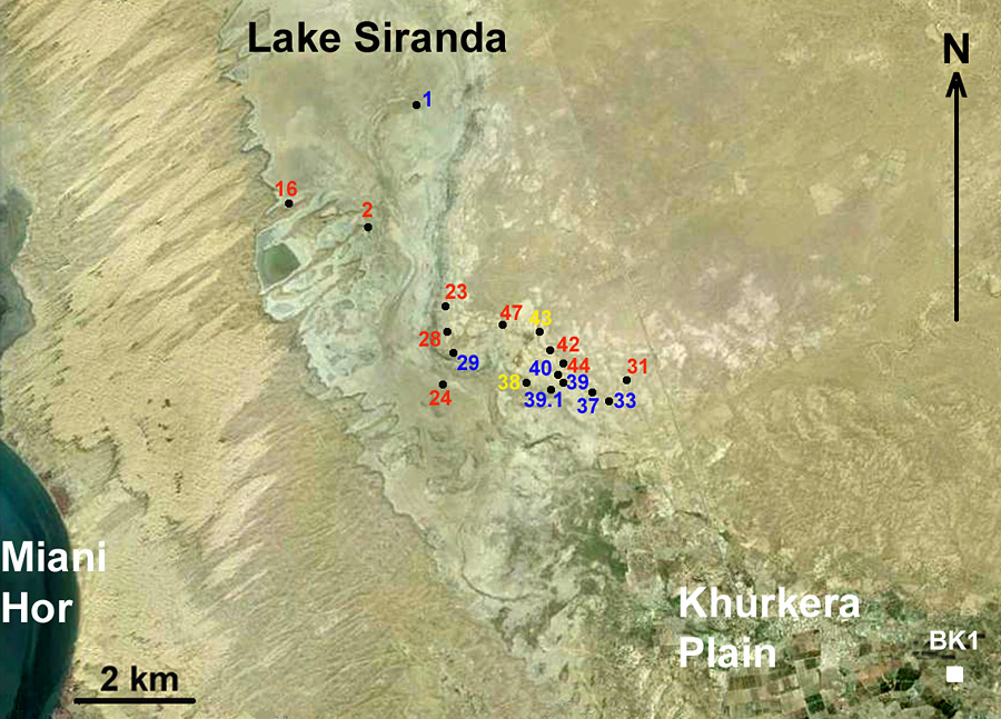
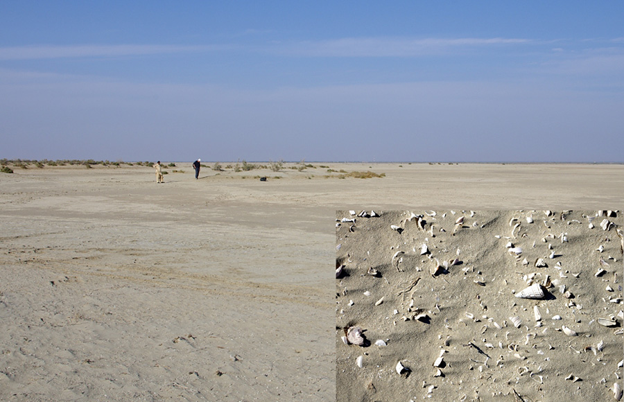
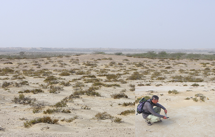
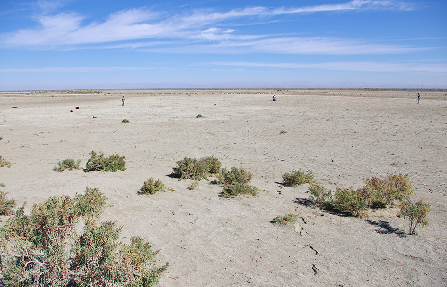
The only known prehistoric site in the territory before the new survey work was Balakot (Kot Bala), a stratified Chalcolithic/Bronze Age mound located in the northern part of the Khurkera plain, excavated by G. Dales in the 1970s (Reference DalesDales 1974, 1979). The 2011–2013 surveys led to the discovery of 73 archaeological sites along the ancient shores of Siranda, 18 of which were AMS dated (Figure 2). They consist mainly of shell middens of different sizes and shapes, sometimes forming clusters within very restricted areas. They are characterised by huge mounds, or small scatters or heaps, of fragmented mangrove gastropods (Terebralia palustris & Telescopium telescopium) (Figure 3), often found associated with other species of marine and mangrove shells, mainly bivalves. Very large middens were discovered mostly along the south-eastern shores of the lake, where the basin begins to narrow (Figure 4), although another very large site, some 75m in diameter, was discovered along the south-western shore (Figure 5).
Lake Siranda: distribution map of the shell middens, AMS dated to the eighth millennium (yellow), seventh millennium (blue) and sixth millennium BP (red). BK1 is Balakot (drawing by R. Nisbet).

Lake Siranda: site SRN 2 in the background, and scatters of T. palustris, T. telescopium and marine bivalves on the surface of SRN 1 in the lower right corner (photographs by P. Biagi).

Lake Siranda: site SRN 29 in the background, and scatter of T. telescopium gastropods on the surface of SRN 30 in the lower right corner (photographs by P. Biagi).

Lake Siranda: the white spot of site SRN 67, the largest shell midden so far discovered along the south-western shore of the basin (photograph by P. Biagi).

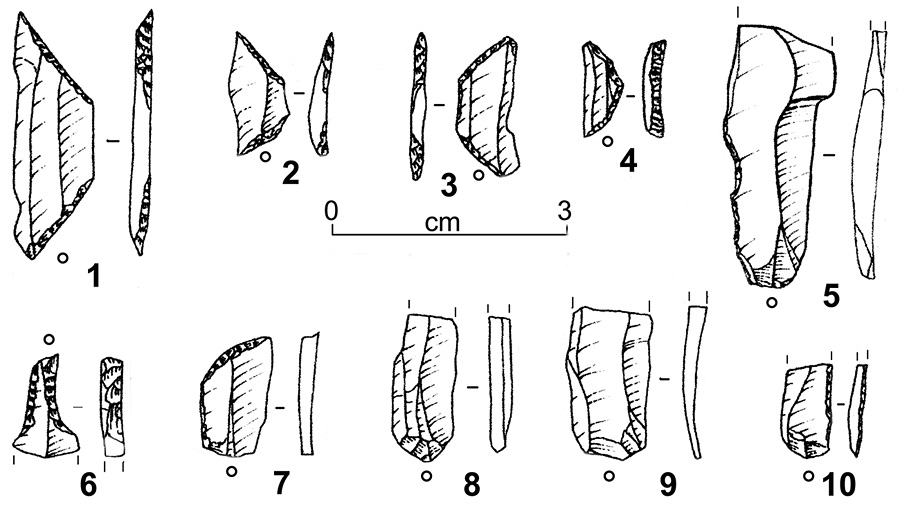
Lake Siranda: chipped stone tools of Gadani reddish-brown flint from shell midden SRN 29: trapezoidal geometrics (nos. 1–3), lunate (no. 4), backed bladelets (nos. 5 & 10), micro-drill (no. 6), truncation (no. 7) and unretouched bladelets (nos. 8 & 9) (drawings by P. Biagi, inking by E. Starnini).

Apart from mangrove and marine shell fragments, the sites yielded characteristic items of material culture among which are chipped stone tools—often obtained from bladelets of Gadani reddish-brown flint (Naseem et al. 1996–1997)—represented by different types of microlithic geometrics, mainly isosceles trapezes and lunates (Figure 6), as well as a few net weights, ground stones and pestles. Small fragments of pottery have also been recovered from a few sites.
The radiocarbon chronology
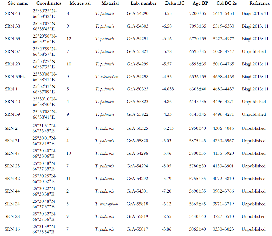
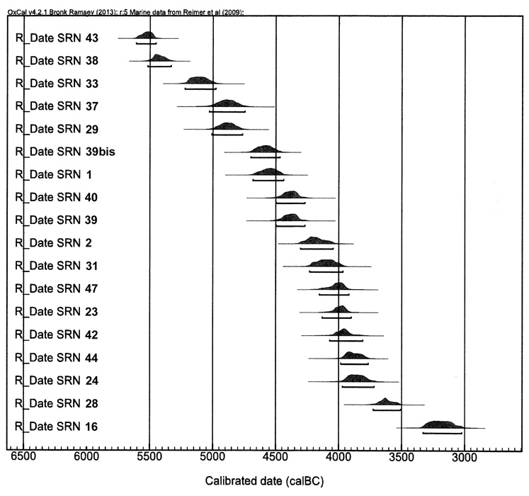
As mentioned above, 18 shell middens have been AMS dated from single, adult mangrove shell specimens, preferably T. palustris. The results obtained so far (Figure 7; Table 1) show that the Siranda shores were settled for a period of some 2000 years between the last two centuries of the eighth and the second half of the sixth millennia uncal BP, that is, during the Neolithic and part of the Chalcolithic periods, when the Arabian Sea level was some 3m higher than present (Reference LambeckLambeck 1996) and the lake was a tidal lagoon of the Arabian Sea partly surrounded by a mangrove environment.

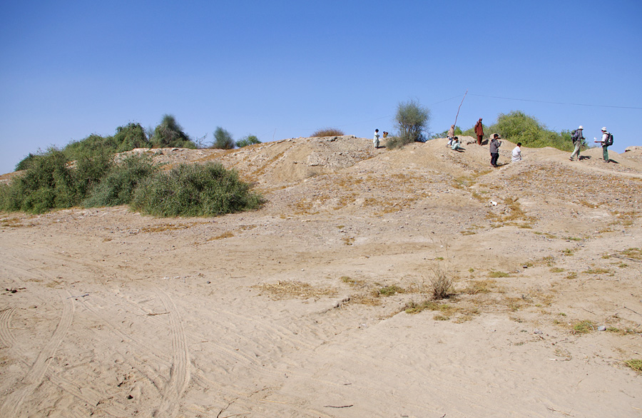
Following the retreat of the ocean, after the middle of the sixth millennium BP, and the consequent disappearance of the mangrove forests, the territory dried up and, as the surveys have shown, was never settled again—even in historical times. Nevertheless, it is important to point out that one specimen of T. palustris, collected from the surface of Balakot mound (BLK 1; Figure 8) was AMS dated to 4660±40 BP (2831–2498 cal BC at 2s: GrA-55828). This assay, which is some 500 years later than the most recent results obtained from the Siranda sites, shows that Balakot inhabitants exploited another mangrove environment, possibly located along the shores of Miani Hor.
Lake Siranda: chronological distribution of the calibrated dates from the different sites. Data from Table 1 (scatterplot by T. Fantuzzi).

Balakot: the prehistoric mound from the south-east (photograph by P. Biagi).

Conclusion
The AMS dates obtained from the Siranda shell middens contribute to the definition of the Holocene peopling of the northern coast of the Arabian Sea, of which very little was known as recently as 10 years ago. The discovery of shell middens around the Bay of Daun, along the coast of Las Bela (Reference BiagiBiagi 2004, 2011; Biagi et al. 2013), and on the limestone outcrops rising from the Indus delta (Reference BiagiBiagi 2009, 2013), have radically changed our view of the Neolithic peopling of this part of the Arabian Sea. Indeed, the research at present underway along the southern coast of the Sultanate of Oman has revealed a very similar pattern of mid Holocene human exploitation, with groups of fisher-gatherers settled along the shores of former tidal lagoons, in a period of maximum expansion of the mangrove environments (Lézine et al. 2002; Berger et al. 2005, 2013).
Acknowledgements
The authors are very grateful to Professor M. Khalid Badini (University of Balochistan, Quetta) for organising their stay at Uthal Circuit House during the 2012 and 2013 fieldwork seasons at Lake Siranda, and to Professor M. Altaf Bouk, former director of the Department of Informatics at the University of Balochistan. Thanks are also due to Mr Iftikhar Badini, Haqdil Hakeem and Muhammad Qasim, students of Uthal Maritime and Agricultural University, who took part in the 2012 and 2013 surveys, and to Dr E. Starnini (Turin University, Italy) for the reassessment of Figures 3 and 4. Research at Las Bela was made possible thanks to contributions from the Italian Ministry of Foreign Affairs (MAE, Rome), and the Ca' Foscari University Archaeology Research Funds (Venice). Thanks are due also to EURAL Gnutti Ltd. (Rovato, Brescia) for financing some of the AMS dates.