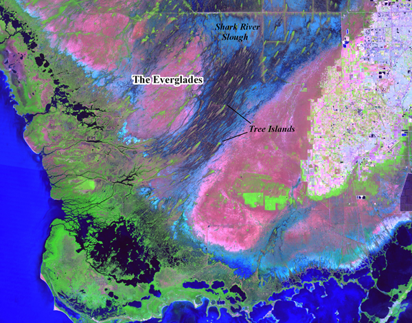
The Everglades span the entire southern half of Florida, covering over a million and a half acres, and constitute the largest subtropical wetland in North America. The park is a vast plain, with a maximum elevation of no more than ten feet above sea level. The centre of the plain forms a slight depression ten miles wide, known as Shark River Slough. This interior sawgrass river contains extensive wet prairies and hundreds of small, elevated tear-drop shaped tree islands (Figure 1). The northern ends of tree islands contain small circular to oval-shaped areas of high ground, vegetated with tropical hardwood trees.
Satellite photo of south Florida showing the Everglades, Shark River Slough, and tree islands.

In 2004, the National Park Service's Southeast Archaeological Center (SEAC) began an archaeological investigation of the Everglades National Park's Eastern Expansion Area, located along the eastern edge of the Shark River Slough. With a total survey area exceeding 107 600 acres (43 545 hectares) of subtropical wetlands, the main goal of the project was to maximize identification of archaeological sites.
Survey methodology included using Geographic Information Systems (GIS) to adapt a predictive model for prehistoric site locations within south Florida wetlands, developed by Carr (1974) and Ehrenhard (1978), and tested by Schwadron (2002). The model's hypothesis is that in south Florida wetlands, prehistoric sites would most likely be situated on the highest ground, i.e., tree islands.
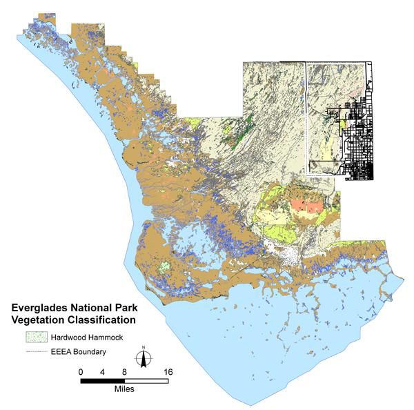
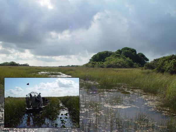
Using ArcGIS™, a highly-detailed vegetation coverage (Vegetation Classification System for South Florida National Parks) (Madden et al. 1999) was used to query vegetation classes that have a high association with archaeological sites, including hardwood hammocks, bay heads and willow tree islands (Schwadron 2004) (Figure 2). Airboats were used to access sites, and each tree island target was tested archaeologically (Figure 3). Results of the project determined that out of 43 high potential tree island site targets, 42 were confirmed to be archaeological sites (Schwadron 2006).
Everglades National Park, GIS vegetation classification coverage, with query for hardwood hammock locations.

Typical tree island. Inset: Tree islands are only accessible with shallow-bottomed "airboats".

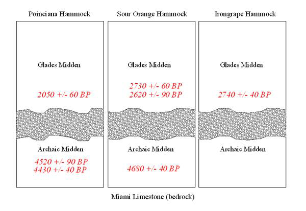
Thin section analysis, Scanning Electron Microscope (SEM) and an Electron Microprobe analyses suggests that the layer appears to be a form of organic, laminar calcrete, consisting of many fine, laminated bands of micrite or mudstone, which probably formed during repeated episodes of sub-aerial exposure, possibly during seasonal wet and dry cycles. This indicates that the calcrete is authigenic (naturally grown in place), and did not form due to weathering or being transported in. Since a thick layer of purer carbonate cannot "ingrow" cleanly into existing sediment (Stone et al. 2006), the calcrete therefore formed in situ, during the time in-between the earlier Archaic and latter Glades occupations of tree islands. The radiocarbon dated artifacts from above and below the layer, the absence of artifacts from within the layer, and various geological analyses supports the premise of an occupational hiatus of tree islands during roughly 4400 BP to 2700 BP.
All sites identified are prehistoric black earth middens, composed of dark brown to black organically stained soil intermixed with very dense vertebrate faunal remains, ceramics, and other midden debris. Marine shell was present, but comprises no more than a quarter of the matrix. These sites, like shell middens, are domestic accumulations of debris, and are thought to suggest evidence of coastal populations who maintained central settlements and used interior tree islands as special use sites (Athens 1983). Current models suggest that interior tree islands were not settled until after 2500 BP (Widmer 1988).
Several significant finds resulting from this investigation will considerably alter our understanding of the human prehistory and settlement of the Everglades. One is that five Late Archaic sites were identified that date considerably earlier than previously thought for the interior Everglades. Sour Orange, Poinciana, Irongrape, Heartleaf, and Grossman's Hammocks all contained deeply buried, well-preserved archaeological deposits indicating that Archaic peoples hunted, fished, processed food, manufactured marine shell tools, built fires, and lived along the developing Everglades tree island landscape over 5000 years ago. Several sites contain examples of the first manufactured pottery types (fiber-tempered) in North America, while others are pre-ceramic, suggesting the possibility of different groups migrating into the region.
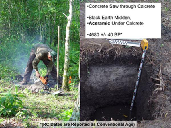
The second significant find is the presence of a buried, hardened, mineralized carbonate soil layer within the tree islands. This layer, temporarily identified as a form of calcrete, was encountered within every tree island tested, and was too hard to break through with hand tools or cores. At two tree islands, a concrete saw was used to break through the layer, and at both sites, well-preserved organic soil, sediment, and archaeological deposits were found deeply buried beneath the layer (Figures 4 & 5). Radiocarbon dates above and below the layer at several sites bracket the formation of the layer from about 4400 BP to 2700 BP. Artefacts above the layer date to the Pre-Glades and Glades period, whereas underneath the layer, artefacts and radiocarbon dates suggest Late Archaic period occupations (Figure 6). Absence of artefacts within the layer suggests an occupational hiatus, and that human use and settlement of tree islands shifted, perhaps influenced by changes in water levels, climate or other environmental conditions.
A concrete saw was used to excavate through the hardened calcrete layer. At the Sour Orange Hammock site, Archaic deposits date to 4680 BP underneath the layer.

Profile of Poinciana Hammock, showing dated Glades Midden above the calcrete layer and dated Archaic deposits below the layer, with a dense black earth midden containing worked and unworked bone, marine shell, fiber-tempered ceramics and other artefacts.

Other south Florida sites have also been reported to have a similar mineralized layer (Reference LaxsonLaxson 1962, Reference Laxson1970; Mowers 1972; Mowers & Williams 1972, 1974; Williams & Mowers 1977, 1979:26; Graves 1982; & Masson et al. 1988), but none have been systematically examined in depth, and all have been interpreted as an anthropogenic formation, the results of humans intentionally piling up marsh marl soils. Artefacts and radiocarbon dates above and below some of these sites also indicate a similar temporal correlation, suggesting the layers formed from around 3800 BP to 2700 BP (Mowers 1972: 129; Mowers & Williams 1972:7; Masson et al. 1988). The layer therefore appears to mark a potentially important regional cultural shift in the prehistoric settlement of south Florida.
While no definite conclusions can yet be made, several correlations are offered. Recent palynological work from southwest Florida suggests that changes in El Niño intensity lead to an increase in water inputs and wetland vegetation, possibly during the time of the layer's formation. Pollen records and radiocarbon-dated peat cores from nearby Fakahatchee Preserve indicate a significant shift from a drier, pine dominated wet prairie to a wetter swamp forest between 3500 BP and 2000 BP (Donders et al. 2005). Our data concurs with other world data-sets which indicate a general shift to wetter conditions caused by an El Niño intensification occurred between 3500 BP to 3100 BP (Reference BradleyBradley et al. 2003:107, Reference GrosjeanGrosjean et al. 1995, Reference Grosjean1997). Other examples from Venezuela and Peru also suggest that high-amplitude fluctuations in El Niño intensity and precipitation occurred during the time interval 3800 to 2800 years ago, causing increased climate variability (Sandweiss 1996, Sandweiss et al. 1996:1531, Haug et al. 2001).
While the origin of the layer is still not well-understood, we continue investigations into the nature and formation of the layer, including geochemical, geological, palynological and sediment studies. Understanding the formation processes of the layer will help us to understand what palaeo-environmental processes and possible climate changes may have occurred during its formation, how interior wetlands were first settled, why they were abandoned, and how Holocene variability may have effected both tree island formation and human settlement in the region. Most importantly, this study determined that deeply buried Archaic deposits occur within Everglades tree islands, and are likely located below the mineralized layers on most, if not all tree islands in south Florida. This indicates that contrary to current models stating that the interior Everglades were not settled until after 2500 BP, they were in fact intensively occupied during the Archaic.