




Introduction
The retreat of the Antarctic Peninsula Ice Sheet since the Last Glacial Maximum (LGM) represents a critical aspect of past and ongoing cryosphere change, offering valuable insights into ice-sheet dynamics, climate interactions and global sea-level contributions. During the LGM (~26.5–19.0 ka ago; Clark et al. Reference Clark, Dyke, Shakun, Carlson, Clark and Wohlfarth2009), the Antarctic Peninsula Ice Sheet extended across the continental shelf, reaching the outer shelf break in many sectors (Davies et al. Reference Davies, Hambrey, Smellie, Carrivick and Glasser2012, Cofaigh et al. Reference Cofaigh, Davies, Livingstone, Smith, Johnson and Hocking2014). However, post-glacial warming and oceanic influences have driven significant ice retreat, leading to progressive grounding-line migration and ice-shelf disintegration (Bentley et al. Reference Bentley, Cofaight, Anderson, Conway, Davies and Graham2014). Geological and geophysical evidence, including marine sediment cores, terrestrial cosmogenic nuclide (TCN) dating and ice-sheet modelling, indicates a complex, spatially variable retreat pattern influenced by climatic forcing and topographic controls. Understanding these retreat mechanisms is critical for predicting the future stability of the West Antarctic Ice Sheet under anthropogenic climate change scenarios.
Cosmogenic surface exposure dating has emerged as a crucial method for reconstructing the retreat history of the Antarctic Peninsula Ice Sheet by providing direct chronological constraints on deglaciation. This technique relies on the accumulation of TCNs, such as beryllium-10 (10Be) or chlorine-36 (36Cl), in rock surfaces exposed to cosmic radiation after ice retreat. The timing of past ice-sheet thinning and grounding-line retreat could be determined by measuring these isotopes in glacially transported erratics and bedrock surfaces (Dunai Reference Dunai2010, Schaefer et al. Reference Schaeffer, Codilean, Willenbring, Lu, Keisling, Fülöp and Val2022).
However, applying cosmogenic exposure dating on the western side of the Antarctic Peninsula presents significant challenges due to the region’s persistent ice cover and dynamic landscape (Johnson et al. Reference Johnson, Venturelli, Balco, Allen, Braddock and Campbell2022). Unlike other parts of Antarctica, where ice-free nunataks preserve glacial deposits, the Western Antarctic Peninsula (WAP) consists primarily of numerous ice-covered islands, with only small, low-elevation portions remaining glaciation-free. Moreover, the few exposed nunataks are often very steep to nearly vertical and subject to frequent rockfalls, continuously erasing any potential exposure history (Halberstadt et al. Reference Halberstadt, Balco, Buchband and Spector2023). Consequently, the limited bare rocks near sea level on ice-free islands, where some datable glacial deposits are present, represent the only viable locations for reconstructing glacier retreat histories on the WAP.
However, some of these deposits were underwater and later emerged due to ongoing isostatic uplift and sea-level changes (Huybrechts Reference Huybrechts2002). The combined effects of relative sea-level change along the shorelines of WAP islands result in previously submerged sites emerging and becoming exposed to cosmic radiation. This process may provide valuable insights into the relative sea-level changes of nearshore WAP environments.
In this study, we applied the TCN dating technique to seven emerged erratic boulders and two bedrock samples below the LGM marine limit of the WAP to infer the glacial retreat histories and their interaction with the relative sea-level changes during the Late Holocene. We also compiled all published TCN dates on the Antarctic Peninsula to compare our results and discuss the complications and methods for correcting the sampling of emerged erratic boulders along Antarctic Peninsula shorelines.
Study area
The Antarctic Peninsula is a narrow, spine-like mountainous region extending more than 1500 km in length, with peaks rising to 3500 m above sea level (m asl), although most are significantly lower (Fig. 1). The Antarctic Peninsula is heavily glaciated mainly by an ice sheet, with numerous outlet glaciers terminating in the ocean along the eastern and western margins. This glacial boundary extends farther south on the western side (67–70°S) compared to the eastern side (64–68°S) of the Antarctic Peninsula (Fig. 1b; Bentley et al. Reference Bentley, Hodgson, Smith, Cofaigh, Domack and Larter2009).
Location maps of the study areas. a. The location of the Antarctic Peninsula (AP) is shown in red box. b. Detailed view of the AP with locations of studied areas of c. Nansen Island, d. Galindez Island and e. Horseshoe Island. Red diamonds indicate the terrestrial cosmogenic nuclide sampling sites. Background maps were taken from the Quantarctica database (Matsuoka et al. Reference Matsuoka, Skoglund, Roth, de Pomereu, Griffiths and Headland2021).

The Antarctic Peninsula has contrasting climatic conditions on its eastern and western sides. The WAP mountains form an orographic barrier to the prevailing strong, moisture-laden westerly winds. This orographic barrier results in a polar-maritime climate in the west and a polar-continental climate in the east. The WAP is strongly influenced by warm, moist air masses originating from mid-latitudes, leading to a relatively mild and wet climate (Mayewski et al. Reference Mayewski, Meredith, Summerhayes, Turner, Worby and Barrett2009, Bozkurt et al. Reference Bozkurt, Carrasco, Cordero, Fernandoy, Gómez-Contreras, Carrillo and Guan2024). In contrast, the eastern side is significantly colder and drier due to the northward penetration of cold Antarctic air masses into the Weddell Sea embayment (Wille et al. Reference Wille, Favier, Gorodetskaya, Agosta, Baiman and Barrett2025).
Geologically, the Antarctic Peninsula shares similar formations with the South American Cordillera, consisting of a pre-Jurassic basement overlain and intruded by Jurassic-Tertiary magmatic arc rocks, formed due to eastward-directed subduction along its Pacific margin (Jordan et al. Reference Jordan, Riley and Siddoway2020).
We conducted our study on three islands - Nansen, Galindez and Horseshoe islands - running from north to south along the coast of the WAP. The study area extends from 64°S to 68°S latitudes (Fig. 2).
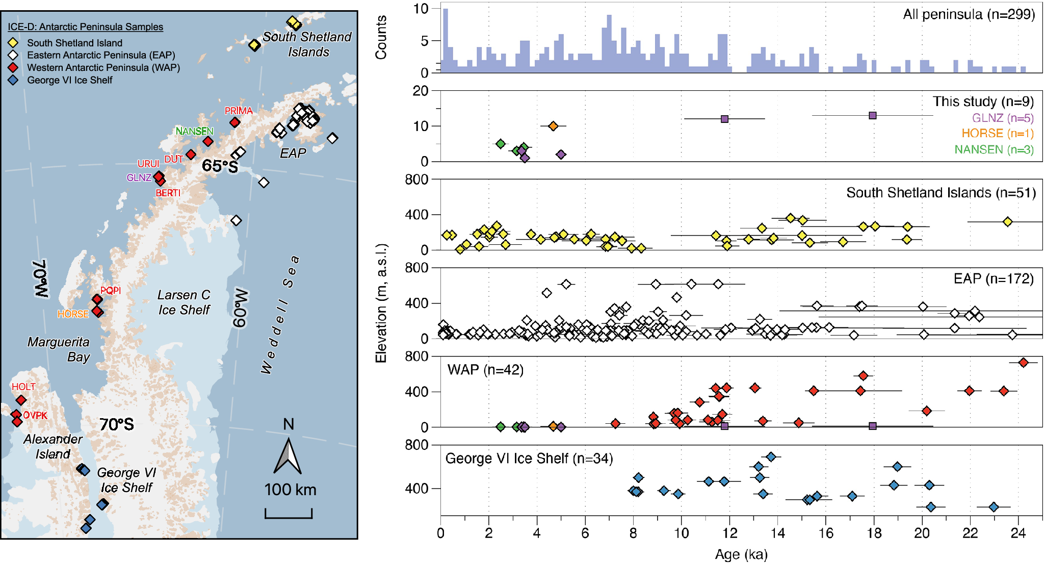
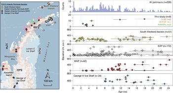
Compilation of published terrestrial cosmogenic nuclide ages from the Antarctic Peninsula. The data were generated from the ICE-D Antarctica informal cosmogenic-nuclide exposure-age database (ICE-D Antarctica 2025a). Colour-coded sample locations are shown on the map. The top graph shows the histogram of all available ages on the peninsula north of 72°S latitude. All ages were recalculated using an online exposure age calculator (version 3, Balco et al. Reference Balco, Stone, Lifton and Dunai2008) with the ‘St’ scaling scheme. Internal uncertainties were used to compare the cosmogenic exposure ages. Bedrock samples are indicated with squares. BERTI = Berthelot Island; DUT = Duthier’s Point; EAP = eastern Antarctic Peninsula; GLNZ = Galindez Island; HOLT = Mount Holt; HORSE = Horseshoe Island; NANSEN = Nansen Island; m a.s.l. = metres above sea level; OVPK = Overton Peak; PQPI = Pourquoi-Pas Island; PRIMA = Primavera Station; URUI = Uruguay Island; WAP = western Antarctic Peninsula.
Nansen Island
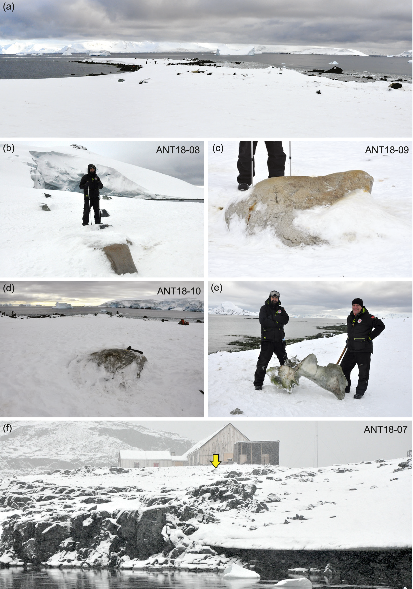
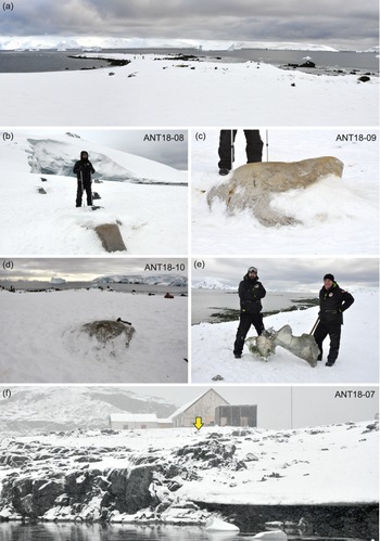
Nansen Island (64.55°S, 62.07°W) is a small island located in the Wilhelmina Bay off the Danco Coast of the Antarctic Peninsula (Fig. 1c). It is part of the group of ice-covered islands scattered along the peninsula’s western coastline (Külköylüoğlu Reference Külköylüoğlu2023). The island is almost entirely covered by an ice cap. The island’s summit lies slightly south of its centre, and the sweeping ice surface is abruptly truncated at the shoreline, where it often forms cliffs or slopes. While the interior remains largely smooth and unbroken, the ice near the shore is heavily crevassed, with fractures running parallel to the coastline (Fleming Reference Fleming1940). Our samples were collected from the San Luis Punta on the north-eastern part of the island (Fig. 3a). The San Luis Punta is a narrow peninsula, ~500 m long and up to 50 m wide. Its top surface is relatively flat, resembling an abrasion platform, with a mean elevation of ~2–3 m asl. This surface is covered with beach pebbles and cobbles, along with several boulder-sized, pink-coloured granite erratics.
a. General view of the sampling site in the San Luis Punta area, Nansen Island, and b.–d. field pictures of individual samples on Nansen Island. e. An undated remnant of a whale near the sample site of ANT18-09 on the San Luis Punta, Nansen Island. f. The former British Antarctic Survey’s Research Base Y and general view of the sampling site (ANT18-07, shown by the yellow arrow) from Horseshoe Island.
Galindez Island
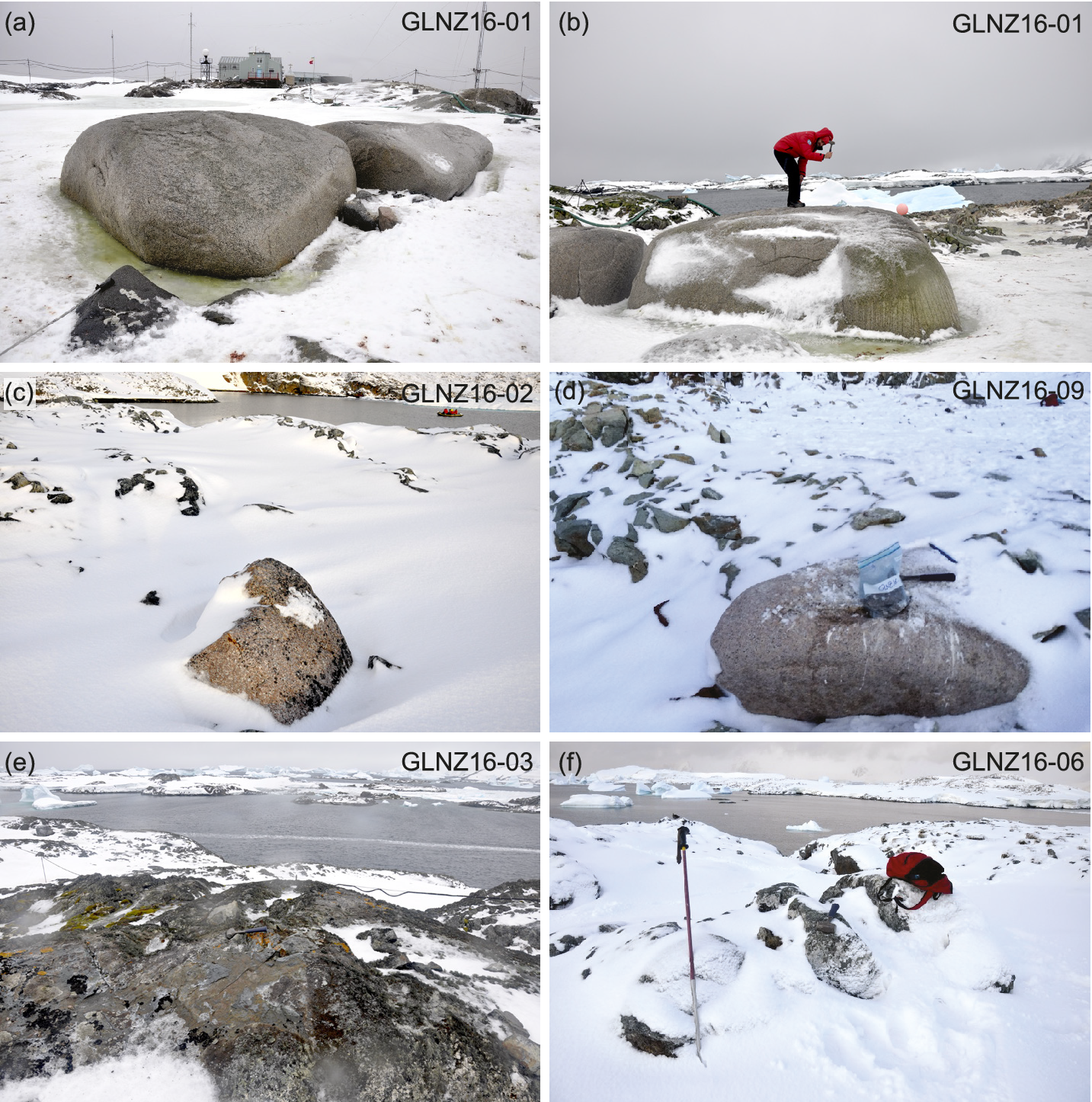
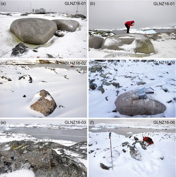
Galindez Island (65.25°S, 64.25°W) is located in the central part of the Argentine Islands, in the Argentine Archipelago-Kyiv Peninsula region in the northern part of the Graham Coast (Fig. 1d). It is best known as the site of the Vernadsky (Akademik Vernadsky) Research Base of Ukraine (Yevchun et al. Reference Yevchun, Fedchuk, Drohushevska, Pnyovska, Chernyshenko and Parnikoza2021). Geologically, the island is composed predominantly of Upper Jurassic volcanic rocks, mainly andesite lavas and dacite pyroclastics, which have been metamorphosed during the Late Cretaceous (Elliot Reference Elliot1964). Only the southern part of the island is covered by an ice cap (~50 m asl at its peak), leaving the rest of the rugged landscape exposed while it was retreating from most of the island (Levashov et al. Reference Levashov, Yakymchuk, Usenko, Korchagin, Solovyov and Pishchany2004). The island itself takes the form of a roche moutonnée (Thomas Reference Thomas1963, Karušs et al. Reference Karušs, Lamsters, Chernov, Krieväns and Ješins2019). Our samples were collected along the northern coast of the island from Marina Point on the west to Podillia Ridge on the east (Fig. 4).
Field pictures of samples from Galindez Island. View of sample GLNZ16-01 are given in a. and b. Field photographs of samples GLNZ16-02 and GLNZ16-09 are given in c. and d., respectively. The bedrock samples from Galindez Island, GLNZ16-03 and GLNZ16-06, are shown in e. and f., respectively. Ukraine’s Vernadsky Station is shown in the background of a.
Horseshoe Island
Horseshoe Island (67.83°S, 67.23°W) is the third largest island in the northern part of Marguerite Bay. Two-thirds of its ~64 km2 surface is covered by glaciers, semi-perennial ice and snow (Fig. 1e; Yıldırım Reference Yildirim2019). The island is composed of foliated granitic and banded gneisses from the Antarctic Peninsula Metamorphic Complex (Matthews Reference Matthews1983), dated to the Lower Jurassic (Velev et al. Reference Velev, Lazarova, Karaoglan, Vassilev and Sselbesoğlu2023). The overlying Antarctic Peninsula Volcanic Group comprises foliated volcanics and sediments (Matthews Reference Matthews1983). Additionally, the Andean Plutonic Suite includes numerous white- and brick-red-coloured granitic intrusions, gabbro and diorite of Cretaceous age (Loske et al. Reference Loske, Herve, Miller, Pankhurst and Ricci1997).
While the southern side of Horseshoe Island is mostly glaciated, featuring Mount Breaker at 879 m asl, the northern part presents a smooth topography where the British Antarctic Survey’s Research Base Y operated from 1955 to 1960. One erratic cobble sample (ANT18-07) was collected near this base (Fig. 3f).
Stretching from north to south, the island is separated by a mostly ice-free, flat-lying narrow central passage (1 km × 1.5 km) at ~80–100 m asl (Yıldırım Reference Yildirim2019). 14C ages from a lake (Hodgson et al. Reference Hodgson, Roberts, Smith, Verleyen, Sterken and Labarque2013) and 10Be TCN surface exposure dating of granitic erratic boulders suggest that the island has been partially ice-free since ca. 10 ka. The 10Be TCN ages range from 12.9 ± 1.1 to 9.4 ± 0.8 ka, with the youngest age being the most accurate for indicating the deglaciation (Çiner et al. Reference Çiner, Yildirim, Sarikaya, Seong and Yu2019). A recent 10Be TCN dating study of the lateral moraine of Shoesmith Glacier (the island’s largest glacier) indicates a Late Neoglacial (Little Ice Age) advance (Çiner et al. Reference Çiner, Yildirim, Sarikaya, Klanten, Oliva, Seong and Yu2025). The shingle-raised beaches on the island’s eastern and western coves produced Late Holocene 10Be TCN ages (Yıldırım et al. Reference Yildirim, Çiner, Sarikaya and Hidy2024). In 2019, the temporary Turkish Antarctic Research Station was established on Lystad Bay of Horseshoe Island (Karatekin et al. Reference Karatekin, Uzun, Ager, Convey and Hughes2023).
Methodology
Sample collection
Samples were collected during two separate Antarctic expeditions. The first was conducted in 2016 as part of the first Turkish Antarctic Scientific Expedition, jointly operated with the 30th Ukrainian Antarctic Expedition at Galindez Island. During this trip, we collected five samples from the island, two of which came from bedrock surfaces (Fig. 4e,f). The second sampling mission was carried out by the Turkish team in 2018. We sampled three boulders from Nansen Island and an erratic cobble from Horseshoe Island (Fig. 3). We intentionally selected our samples from low-lying nearshore sites (< 13 m asl), where the effects of sea-level surface emergence could be observed (Table I).
Field information and cosmogenic exposure ages of the samples.
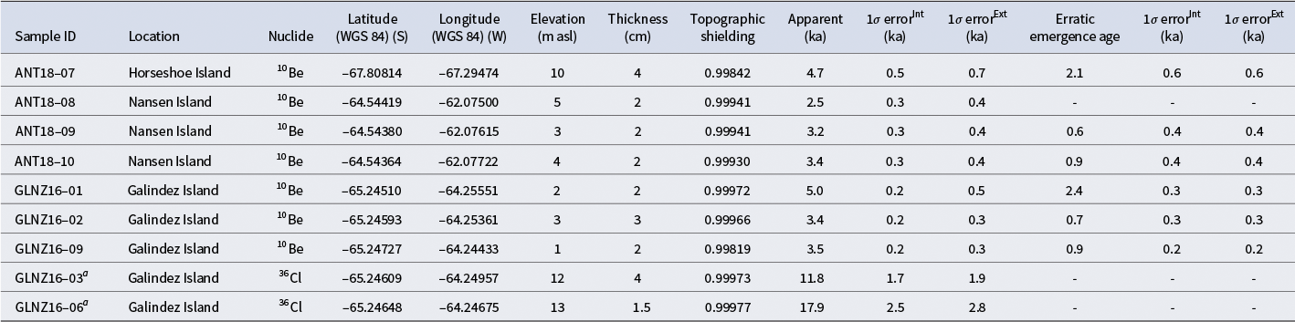
Notes: All exposure ages were computed assuming zero erosion and a rock density of 2.65 g cm−2, using the online exposure age calculator of Balco et al. (Reference Balco, Stone, Lifton and Dunai2008) with the ‘St’ scaling scheme and implemented production rate calibration dataset. Both internal uncertainties (including measurement uncertainties only) and external uncertainties (also including production rate uncertainties) are shown. Emergence ages are corrected for inheritance due to submergence underwater and should be considered as minimum ages. All other ancillary information regarding the samples can be found in Table S1.
a Bedrock samples.
Ext = external; Int = internal; m asl = metres above sea level; WGS 84 = World Geodetic System 1984.
We used a hammer and chisel to collect samples from the upper few centimetres of the rocks, recording both the sample thickness and their inclination to the horizon. We prioritized the largest available boulders in all areas except on Horseshoe Island, where only a single cobble-size erratic (ANT18-07) could be collected. Two bedrock samples were selected from high-standing rock outcrops. We used a handheld GPS unit to record sample locations and assumed ± 1 m elevation uncertainty for all samples.
Cosmogenic nuclide analysis
The lithology of the erratic samples (i.e. granitoids) allows us to analyse them using cosmogenic 10Be from quartz mineral separates. However, the bedrock samples consist of andesite, which does not contain quartz. In this case, we used whole-rock analysis of cosmogenic 36Cl to determine the timing of exposure of the bedrock surfaces. All samples were first crushed, ground to a 0.25–1.00 mm fraction and leached with Milli-Q water and dilute acids. 10Be and 36Cl samples were prepared in different laboratories using standard procedures from the literature (Binnie et al. Reference Binnie, Dewald, Heinze, Voronina, Hein and Wittmann2019, Mechernich et al. Reference Mechernich, Dunai, Binnie, Goral, Heinze and Dewald2019). 10Be samples were prepared at Korea University following the method outlined by Kim et al. (Reference Kim, Seong, Rhee, Khandsuren, Yu and Eliades2024) and at Scottish Universities Environmental Research Centre (SUERC) laboratories (Glasser et al. Reference Glasser, Clemmens, Schanbel, Fenton and McHargue2009). 36Cl samples were prepared at Istanbul Technical University (ITU)/Kozmo-Lab (Sarıkaya et al. Reference Sarikaya, Candaş, Ege and Wilcken2025). Major and minor element concentrations for 36Cl samples were measured at Activation Laboratories, Inc. (Ontario, Canada), using inductively coupled plasma emission mass spectroscopy (Table S1).
Beryllium isotope ratios were measured with a 6 MV tandem accelerator mass spectrometer (AMS) at the Korea Institute of Science and Technology (Kim et al. Reference Kim, Eliades, Yu, Lim, Chae and Song2017) and with a 5 MV tandem AMS at the SUERC facilities (Xu et al. Reference Xu, Dougans, Freeman, Schnabel and Wilcken2010), both normalized to the standards of Nishiizumi et al. (Reference Nishiizumi, Imamura, Caffee, Southon, Finkel and McAninch2007). Chlorine isotopic ratios were measured using the 6 MV SIRIUS tandem AMS at the Australian Nuclear Science and Technology Organization (ANSTO; Wilcken et al. Reference Wilcken, Fink, Hotchkis, Garton, Button and Mann2017). All essential data (dissolved masses, carrier data, raw isotope ratios, procedural and AMS blanks, etc.) required for recalculating the ages can be found in Table S1.
Data processing and age calculations
We calculated the 10Be and 36Cl exposure ages using online calculators formerly known as the CRONUS-Earth online calculators, version 3 (https://hess.ess.washington.edu; Balco et al. Reference Balco, Stone, Lifton and Dunai2008) with the ‘St’ scaling scheme, ‘ant’ pressure handling flag and implemented production rate calibration in the dataset. Both internal uncertainties (including measurement uncertainties only) and external uncertainties (also including production rate uncertainties) were reported to the 1σ uncertainty level (Table I). We assumed a sample density of 2.65 g/cm3 for all samples and applied corrections for sample thickness and topographic shielding. As erosion rates are low and snow cover on sample surfaces is difficult to estimate (Johnson et al. Reference Johnson, Everest, Leat, Golledge, Rood and Stuart2012), we did not apply erosion or snow shielding corrections, consistent with other studies on the Antarctic Peninsula (e.g. Bentley et al. Reference Bentley, Johnson, Hodgson, Dunai, Freeman and O’Cofaigh2011, Balco et al. Reference Balco and Schaefer2013).
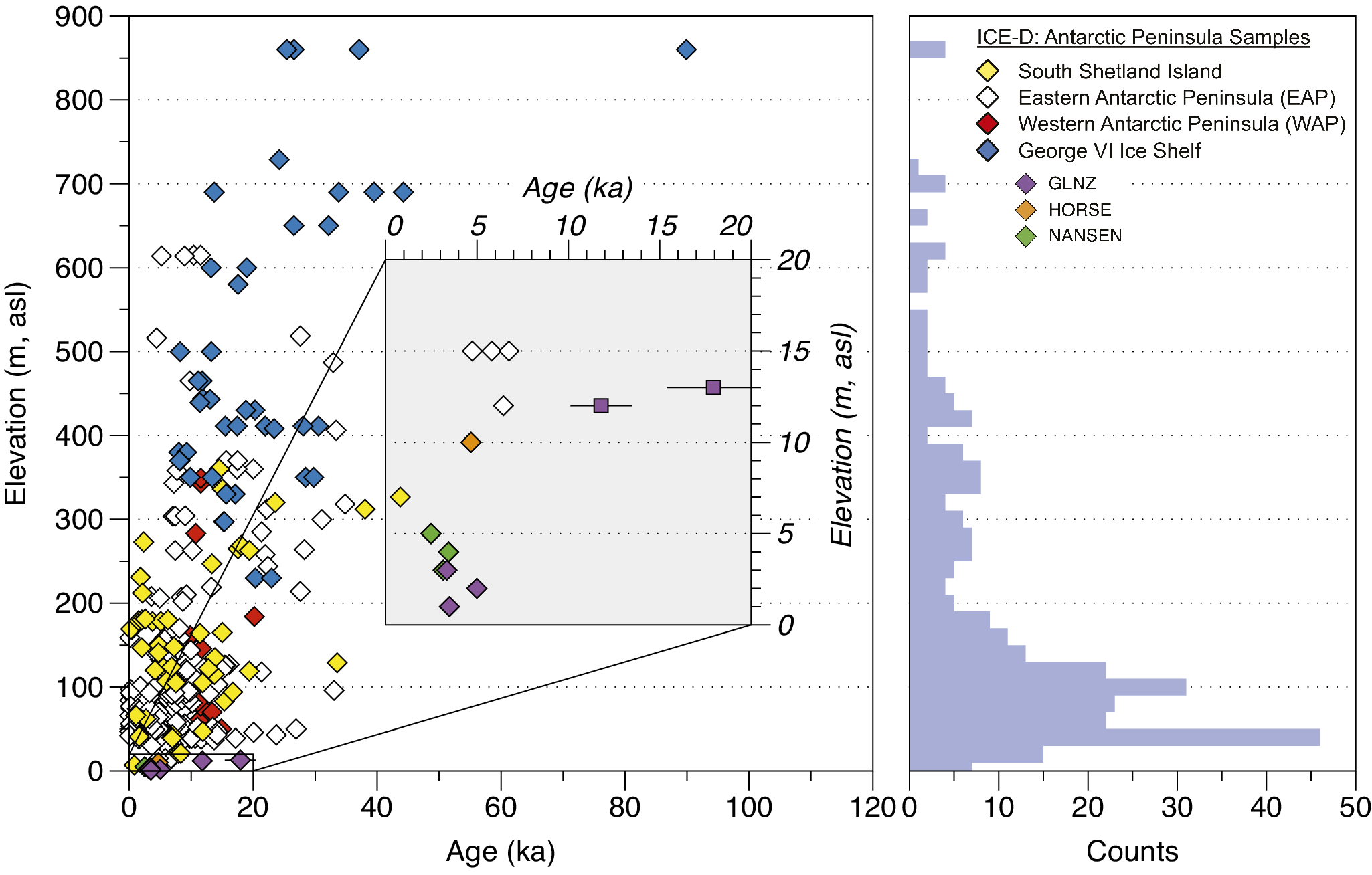
We also compiled all TCN exposure ages to date from the Antarctic Peninsula available in the ICE-D Antarctica database (ICE-D Antarctica 2025a) for comparison with our results (Fig. 2). We focused on sites north of 72°S latitude. A total of 299 published TCN ages exist, 42 of which are from the WAP (including this study). Aside from our samples, only one sample is below 10 m asl (Livingston Island; Oliva et al. Reference Oliva, Palacios, Sancho, Fernández-Fernández, Çiner and Fernandes2024), and four samples are between 10 and 20 m asl (James Ross Island; Kaplan et al. Reference Kaplan, Strelin, Schaeffer, Peltier, Martini and Flores2020) (Fig. 5). Nearly half of the samples (48%) were collected between 20 and 120 m asl (121 m asl is the median). The scarcity of samples near the shoreline (< 20 m asl) indicates hesitation in collecting samples, possibly due to potential issues related to submerged boulders.
Distribution of elevation vs age of all samples from the ICE-D Antarctica database (ICE-D Antarctica 2025b) along the west coasts of the Antarctic Peninsula. The histogram of the elevation distribution of samples (n = 299) is on the right. Abbreviations for sampling sites are given in Fig. 2.

Results
We collected a total of nine samples: two from bedrock surfaces on Galindez Island, three from erratic boulders on Galindez Island, three erratic boulders on Nansen Island and one erratic cobble from Horseshoe Island. The bedrock samples yielded the oldest ages (GLNZ16-03: 11.8 ± 1.9 ka; GLNZ16-06: 17.9 ± 2.8 ka; Table I). These samples were analysed using whole rock for 36Cl. They were taken from an andesite rock outcrop on Karpaty Ridge and Traviane Plateau, respectively, a few hundred metres east of the Ukrainian Antarctic Research Station (Vernadsky) on Marina Point of Galindez Island. The age uncertainties of the two bedrocks do not overlap, precluding us from assigning an average age to this surface.
Three additional erratic samples from Galindez Island yielded 10Be ages ranging from 3.4 ± 0.3 to 5.0 ± 0.5 ka. These samples are situated very close to the present sea level, at elevations between 1 and 3 m asl, along the north coast of Galindez Island, with one (GLNZ16-01) located very close to the north-eastern entrance of Vernadsky Station (Fig. 4a).
Three more samples were collected from the San Luis Punta Peninsula of Nansen Island (Fig. 3). All were taken from low-lying topography at elevations ranging from 3 to 5 m asl and yielded 10Be ages ranging from 2.5 ± 0.4 to 3.4 ± 0.4 ka.
Additionally, one pink granite cobble (10 × 5 × 5 cm in size) was collected from Horseshoe Island (ANT18-07), which yielded a 10Be age of 4.7 ± 0.7 ka.
In general, erratics from Nansen Island yielded the lowest error-weighted ages (3.0 ± 0.3 ka, n = 3), whereas those from Galindez Island yielded error-weighted ages of 4.1 ± 0.6 ka (n = 3). The single cobble sample from Horseshoe Island had an age of 4.7 ± 0.7 ka. As all erratic ages are well clustered and fall within their uncertainties, we calculated a combined error-weighted age for all erratics, assigning a maximum of 3.8 ± 0.3 ka (n = 7) for the emergence time of erratic boulders along the WAP coast. However, we emphasize that these ages are not corrected for inheritance and only represent the maximum age of emergence.
Discussion
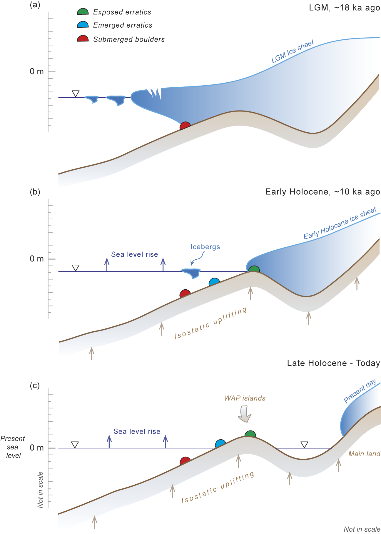
The exposure ages presented here are apparent, meaning they are calculated assuming that each sample underwent a single period of surface exposure without any erosion, cover and/or burial. Potential geological sources of error exist associated with this assumption, including a possible inheritance issue during the submerged stage because of the shielding effect of seawater. As our samples are very close to the shoreline, potential post-glacial geological effects, such as isostatic uplift and sea-level rise, may influence their exposure ages (Fig. 6).
Schematic description of the emergence of erratic boulders on the shoreline of western Antarctic Peninsula (WAP) islands whilst the ice sheet was retreating since a. the Last Glacial Maximum (LGM) and b. the Early Holocene. The present condition of the boulders is shown in c. Exposed erratics (green boulders) represent the boulders deposited on land directly by retreating glaciers. Submerged boulders (red boulders) are erratics deposited under the water, either by retreating glaciers or the icebergs originating from them. Later, submerged boulders emerge onto the land surface due to relative sea-level changes (blue boulders).

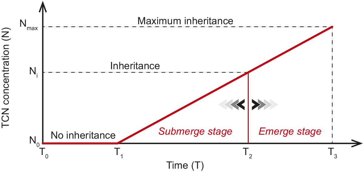
Isostatic uplift occurs when the Earth’s crust gradually rebounds following deglaciation. This process may influence our surface exposure ages. If an erratic boulder was initially deposited under the sea (submerged stage) and later uplifted, it may have been covered by seawater for a period before becoming fully exposed to cosmic rays (emerged stage; Figs 6 & 7). This could result in an overestimation of the true exposure age due to the accumulation of nuclides whilst the sample was submerged.
The changes in terrestrial cosmogenic nuclide (TCN) concentrations of submerged boulders through time. A very short portion of time is shown compared to the full cycle of radioactive cosmogenic isotopes. During the submerged stage, samples were deposited under the water since T0. We assume our samples emerged at sea level at T2 and have been exposed to cosmic radiation since T1. Theoretically, the inherited amount of nuclide concentration (Ni) while samples were sitting under the water should be between Nmax (= Nmeasured) and N0 (no inheritance), depending on the unknown timing of emergence (T2) of the samples to sea level. T3 represents the time of sampling. Left- and right-pointing arrowheads represent the unknown adjustment to the time of emergence.

Uplift rates are not uniform in the Antarctic Peninsula. The northern regions of the Antarctic Peninsula, where ice loss has been more pronounced, tend to experience greater uplift (Nield et al. Reference Nield, Barletta, Bordoni, King, Whitehouse and Clarke2014). Some locations, such as the South Shetland Islands, have been uplifted by more than 20 m since the Early Holocene (Fretwell et al. Reference Fretwell, Hodgson, Watcham, Bentley and Roberts2010). GPS measurements indicate that present-day uplift rates in the Antarctic Peninsula exceed 40 mm per year, particularly in areas experiencing rapid deglaciation (e.g. the Amundsen Sea Embayment; Willen et al. Reference Willen, Wouters, Broerse, Buchta and Helm2024). Relative sea-level data from raised beaches support uplift estimates of 36 m over the past 7.29 ka in Calmette Bay and of 15 m over 3.31 ka in Gaul Cove on Horseshoe Island in Marguerite Bay (Yıldırım et al. Reference Yildirim, Çiner, Sarikaya and Hidy2024). Simkins et al. (Reference Simkins, Simms and Dewitt2013) proposed the Holocene marine limit to be at 21 m asl on Calmette Bay, contrary to the 40.5 m suggested by Bentley et al. (Reference Bentley, Hodgson, Smith and Cox2005) and Yıldırım et al. (Reference Yildirim, Çiner, Sarikaya and Hidy2024). Consequently, earlier studies indicate that the post-glacial marine limit (~15.0–40.5 m asl) is placed well above our sampling sites.
Our samples were deposited underwater during the submergence phase, accumulating a certain amount of the nuclide inventory. If we assume that emergence occurred instantaneously following deposition, the calculated ages would represent the entire duration of surface exposure without any inherited nuclide concentration (Fig. 7). Under this assumption, the exposure ages range from 3.0 ± 0.3 ka on Nansen Island to 4.7 ± 0.7 ka on Horseshoe Island, with a mean value of 3.8 ± 0.3 ka, as presented earlier. Conversely, if we assume that the measured nuclide concentrations were entirely acquired whilst the samples remained submerged and their emergence onto the surface was recent, then the exposure duration would be zero. In this scenario, the calculated ages would not reflect the timing of emergence but instead the maximum possible inheritance due to relative sea-level fluctuations along the WAP coast during the Late Holocene. Therefore, the actual emergence time of the erratics must fall between the age derived under the assumption of no inheritance (3.8 ± 0.3 ka) and that obtained under the assumption of maximum inheritance (recent exposure; Fig. 7). However, we contend that both extreme assumptions are improbable. Theoretically, the inherited nuclide concentration acquired during submergence could range between the measured inventory and zero, depending on the unknown timing of the samples’ emergence relative to sea level.
The evidence indicates a period of submergence offshore, as demonstrated by the identification of several large submerged blocks at depths of less than 25 m along the coastline of Horseshoe Island through shallow acoustic profiling and multi-beam swath bathymetry (Pehlivan & Alpar Reference Pehlivan and Alpar2024, Vardar et al. Reference Vardar, Erturaç, Özcan and Gazioğlu2024). These offshore boulders suggest the deposition of erratics that remain submerged, awaiting eventual emergence (Vardar et al. Reference Vardar, Erturaç, Özcan and Gazioğlu2024). During the submerged stage, cosmogenic neutrons, which can penetrate shallow water (only 37% attenuate to deeper than 1.5 m below the sea surface), continue producing cosmogenic nuclides until full exposure. Additionally, muons, which penetrate greater depths, contribute to the nuclide inventory, particularly in environments characterized by slow relative sea-level change rates. Swirad et al. (Reference Swirad, Rosser, Brain, Rood, Hurst, Wilcken and Barlow2020) corrected the cliff outcrop exposure ages for water shielding by modelling tidal submergence durations and applying depth-dependent attenuation factors for seawater. This ensured that exposure ages reflect true cosmogenic production rather than being underestimated due to periodic water cover. As we do not know the real submerge duration of our samples, we applied a different approach for inheritance correction to determine the true emergence time. Yıldırım et al. (Reference Yildirim, Çiner, Sarikaya and Hidy2024) applied inheritance correction using two 10Be exposure ages (2.88 ± 0.24 and 1.91 ± 0.26 ka) from modern beach gravels. These samples were collected from the lowest available beach ridges within the tidal range of raised beach sediments at Gaul Cove in Horseshoe Island and Calmette Bay, respectively. Surface processes such as wave action and storm surges that continuously rework these clasts probably minimize the inherited nuclide inventory. In contrast, our samples are significantly larger than beach gravels, making them less susceptible to reworking by such processes. Consequently, the inherited nuclide concentration in our samples is expected to be higher than the estimates provided by Yıldırım et al. (Reference Yildirim, Çiner, Sarikaya and Hidy2024).
We propose utilizing the modern beach sediment inventories measured by Yıldırım et al. (Reference Yildirim, Çiner, Sarikaya and Hidy2024) for inheritance correction and estimating the minimum emergence time of our samples. The average 10Be concentration of two gravel samples is 13 200 ± 820 atoms g−1 (Yıldırım et al. Reference Yildirim, Çiner, Sarikaya and Hidy2024). After applying this inheritance correction by subtracting the measured concentrations from our samples, the resulting ages are ~70% younger (Fig. 8b). Notably, as the concentration of sample ANT18-08 is lower than the inheritance correction inventory, its corrected age becomes null. The remaining samples yield ages ranging from 2.4 ± 0.3 to 0.6 ± 0.4 ka, with an average corrected emergence age of 1.4 ± 0.3 ka. Therefore, we argue that the true emergence of our samples should be earlier than 1.4 ± 0.3 ka ago, but not later than 3.8 ± 0.3 ka ago (average age without correction, n = 7).
Age vs elevation graphs of a. all published ICE-D Antarctica database ages (ICE-D Antarctica 2025b) along the west coast of the Antarctic Peninsula and b. samples from this study with relative sea-level curves obtained from raised beaches in Marguerite Bay (from Yıldırım et al. Reference Yildirim, Çiner, Sarikaya and Hidy2024) and from calibrated 14C ages (cal. bp) of various faunal remains (penguin bone, collagen, guano), lacustrine, moss and marine sediments from the South Shetland Islands, Marguerite Bay and Joinville Island, compiled by Lecavalier et al. (Reference Lecavalier, Tarasov, Balco, Spector, Hillenbrand and Buizert2023). The sea-surface temperature (SST) reconstruction from ODP Site 1098 on offshore Anvers Island (Shevenell et al. Reference Shevenell, Ingalls, Domack and Kelly2011) is shown in a. Internal uncertainties were used to compare the cosmogenic exposure ages. The thick black line in a. indicates the WAP’s ice-thinning history based on discussions in the text. Abbreviations and symbology for the sampling sites are given in Fig. 2.

This bracketing age of our samples is comparable with the age range of raised beach sediments on the Gaul and Calmette coves of Marguerite Bay, being 15 and 11 m of relative sea-level change since 3.31 ± 0.31 and 3.35 ± 0.38 ka ago, respectively (Bentley et al. Reference Bentley, Hodgson, Smith and Cox2005, Simkins et al. Reference Simkins, Simms and Dewitt2013, Yıldırım et al. Reference Yildirim, Çiner, Sarikaya and Hidy2024). Furthermore, a subfossil peat on Rasmussen Point (~20 m asl), near Galindez Island, 14C dated to 2.75 ka cal. bp (Yu et al. Reference Yu, Beilman and Loisel2016, Loisel et al. Reference Loisel, Yu, Beilman, Kaiser and Parnikoza2017), shows peatland inception comparable to the maximum emergence age (~3.8 ± 0.3 ka) of our samples. The emergence rates (i.e. the relative sea-level rise) calculated by corrected emergence age of our erratic boulders range from 4.9 m ka−1 at Horseshoe Island to 5.0 m ka−1 at Nansen Island, which is also comparable with the sea-level rise rates obtained from shingle-raised beach sediments in Calmette Bay (4.9 m ka−1) and in Gaul Cove (4.5 m ka−1) on Horseshoe Island (Yıldırım et al. Reference Yildirim, Çiner, Sarikaya and Hidy2024).
Two samples (GLNZ16-03: 11.8 ± 1.9 ka; GLNZ16-06: 17.9 ± 2.8 ka) were obtained from bedrock surfaces on Galindez Island. These samples may contain inherited nuclide concentrations from earlier exposures due to the less erosive nature of cold-based glaciers, which do not effectively remove pre-existing cosmogenic nuclides from the bedrock. Thus, the true age of these samples may be overestimated. On the other hand, typical pre-exposure ages in the Antarctic Peninsula are much older, commonly in the range of 104–105 ka (Johnson et al. Reference Johnson, Nichols, Goehring, Balco and Schaeffer2019), and in some cases exceeding 1 Ma (Hein et al. Reference Hein, Fogwill, Sugden and Xu2014), indicating that our bedrock exposure ages might record the earliest emergence following the deglaciation on Galindez Island. Marine-based radiocarbon data from Heroy & Anderson (Reference Heroy and Anderson2007) indicate deglaciation of the Antarctic Peninsula Ice Sheet between 18 and 9 ka, consistent with our bedrock exposure ages of ~17.9 and 11.8 ka.
Our study provides preliminary records of the true emergence of previously submerged erratic boulders and bedrock surfaces along the WAP coast; a more detailed inventory of nearshore samples is needed to better understand the Late Holocene sea-level history.
Conclusions
We present TCN dating results for six emerged boulders, one cobble and two bedrock surfaces located within the post-glacial marine limit of three WAP islands. Our findings indicate that the average apparent emergence age of erratic boulders, all located less than 10 m above present sea level, is 3.8 ± 0.3 ka. This age assumes single-phase exposure without any shielding effects of seawater. However, isostatic uplift following deglaciation and relative sea-level changes influenced the exposure histories of these boulders, as they were initially submerged and later exposed on land. To account for these factors, we corrected the apparent ages using modern beach gravels with minimal nuclide inheritance. The adjusted emergence ages of erratics range from 2.4 ± 0.3 to 0.6 ± 0.4 ka, with an average of 1.4 ± 0.3 ka. Our study concludes that the true emergence of these boulders occurred between 1.4 ± 0.3 and 3.8 ± 0.3 ka ago, highlighting the ongoing relative sea-level changes affecting the WAP islands since the earliest bedrock exposures of 17.9 ± 2.8 and 11.8 ± 1.9 ka ago obtained from Galindez Island.
Supplementary material
To view supplementary material for this article, please visit http://doi.org/10.1017/S0954102025100394.
Acknowledgements
Part of this study was carried out during the first Turkish Antarctic Research Expedition in 2016, whereas the rest was conducted during the Turkish Antarctic Research Expedition in 2018. This study was conducted under the auspices of the Presidency of the Turkish Republic, with support from the Ministry of Science, Industry, and Technology, coordinated by Istanbul Technical University. The authors thank the Turkish and Ukrainian authorities for their valuable help and support. We thank Dr Klaus Wilcken (Centre for Accelerator Science at ANSTO, Australia) and Dr Derek Fabel (Scottish Universities Environmental Research Centre, UK) for their help in measuring isotope concentrations in some of our samples. We thank Dr Alexander R. Simms and an anonymous reviewer for their helpful comments.
Financial support
The Turkish Ministry of Science and Istanbul Technical University’s Research Funds financed the field trips.
Competing interests
The authors declare that they have no known competing financial interests or personal relationships that could have influenced the work reported in this paper.
Author contributions
MAS, AÇ, CY and IP carried out the fieldwork. MAS and YBS prepared the samples in their laboratories in Turkey and Korea, respectively. BYY measured the samples using accelerator mass spectrometry in Korea. MAS wrote the paper. All of the authors read and approved the manuscript.




 Open access

