
Berkshire
(1) Cookham, Heron’s Court, Terry’s Lane, SL6 9RR (SU 88888 85620): excavation revealed multi-period presence beginning in the Late Bronze Age, with evidence for more substantial structures and land demarcation starting in the late Iron Age/early Roman transition period. Roman activity was divided into three sub-phases. The earliest phase was associated with disuse of a building assigned a late Iron Age/early Roman date, occupying the northern portion of the site. Elements of it were truncated by a rectangular enclosure ditch, possibly open from the second century a.d. To the south of it a single grave was recorded, containing pottery, an iron strap fragment and iron brooch (first–second century a.d.) in addition to highly fragmented human bones. Remains of a building incorporating beam-slots were found within the enclosed area. The structure was without evidence for associated floor deposits, and it is possible that it remained unfinished. To the west, two pits and ditch fragments suggest probable agricultural activity, and in the south-east further post-holes may belong to an enclosure or barn. The second phase was characterised by two rectilinear enclosures, found to the north and south, with associated pitting and a possible fence line. The enclosures were divided by ditches, along with a gated entrance. The southern enclosure was delineated by more substantial double ditches. Toward the end of the latest Roman phase the activity across the site became less intensive, the only evidence for occupation comprising limited dispersed pitting, dated to the fourth century a.d., of little interpretive value. This indicates an abandonment and possible shift in activity at the end of the Roman period.Footnote 124
East Sussex
(1) Bexhill, west of Mount View Street (TQ 748 089): an archaeological excavation and watching brief revealed two phases of ditches, laid out in a roughly rectilinear pattern and probably forming parts of wider field systems, and a series of small, shallow pits, some of which contained charcoal-rich fills. Dating evidence was very limited, but a small assemblage of Roman pottery suggests that the later of the field systems and one of the pits was early Roman in date. The earlier field system may have dated to the Bronze Age.Footnote 125
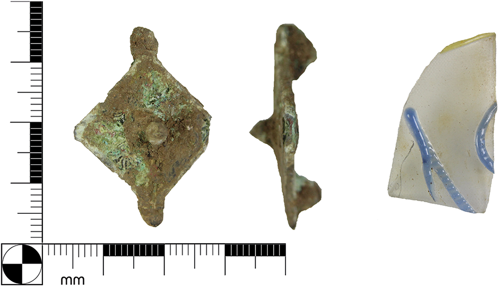
(2) Ringmer, Bridge Farm, Wellingham (TQ 4321 1449): the thirteenth season of investigations in June and early July 2024 saw a return to Trench 7 for a final year before its closure in October.Footnote 126 Five deep pits were excavated, adding to the 30 already opened within this 1400 m2 trench. Also excavated were a possible roadside ditch (F69) and two rows of post-holes (F70 and F71), so adjacent that one must be a replacement for the other, suggesting an important barrier/boundary. Work continued on several features previously opened, including the waterlogged base of pit F48B, which had revealed the corner of a timber frame in 2023. This feature formed a major commitment in 2024 with a large stepped excavation to reveal the complete 700 mm wide square timber frame forming the two bottom courses of the steening of a well. The remains of the well (F48W) were clearly truncated by the later Roman pit (F48B), but were of a distinctive style seen at many other Roman sites in Britain (Fig. 31). The upper layer of timbers was carefully removed and stored for conservation and further analysis, hopefully including dating. Other loose timbers and leather fragments were collected from the liquid mud within the well which was 100% floatated for smaller and environmental finds. A further possible six post-holes were added to the group of seven small, shallow post-hole bases (F62) to form an approximate 5 m square structure. Some of the newly excavated pits showed the vertically sided profile and rectangular plan already seen in earlier excavations. A further 8,273 sherds of Roman pottery were collected giving a total of 81,414 sherds in this trench alone. A further 40 kg of ceramic building material and fired clay were collected and 62 artefacts were recorded as Special Finds, including decorated and/or stamped samian, well timbers and leather, dress ornaments, coins, animal bone, and glass. Of special interest were a sherd of blue snake-thread glass and a lozenge-shaped plate brooch (Fig. 32). The autumn also saw the mechanical removal of top soil from the 1600 m2 Trench 8 over the eastern entrance into the double-ditched enclosure, and the road to Pevensey which will be investigated during June–July 2025 and no doubt beyond.Footnote 127
Well F48W from Bridge Farm, Wellingham, in situ with timber frame and supporting stakes (left), and being carefully lifted (right).

Lozenge-shaped copper alloy plate brooch (BF24, SF627, left) and fragment of vessel glass with blue snake thread (BF24, SF639, right) from Bridge Farm, Wellingham.

(3) Westhampnett (SU 88783 06738): an excavation was undertaken at Goodwood, 2.8 km north-east of Chichester, covering an area of 2.43 ha along the northern side of Roman Stane Street, which linked Londinium (London) to Noviomagus Reginorum (Chichester). A smaller, separately excavated area was located c. 49 m west of the main area. The site produced predominantly Roman material, with the most intense period of occupation between the first and third centuries a.d. A number of features on site remain unphased, including two rectangular post-built structures, but many of these are probably Roman in date. There is also evidence of Neolithic and medieval to modern activity. Roman activity is characterised by numerous ditches, most of which form five (or possibly six) main enclosures and enclosure subdivisions or modifications, along with buildings, cremation burials, pits, post-holes (including a post-hole alignment) and a timber-lined well. The numerous ditch sequences demonstrate continuity of occupation from an early stage. A series of enclosures, not on the Stane Street alignment and producing Late Iron Age to Early Roman pottery, show truncation, ditch recutting, and modification. These may have been established prior to the construction of Stane Street and continued in use through the Roman period. One ditch and structure also yielding Late Iron Age to Early Roman pottery was orientated towards Stane Street. Other early features include a large hollow or working area c. 56.4 m2, and a pit containing at least five cremation burials, four of which were urned, The urns date one burial to the late Iron Age–early Roman period, another as early Roman, and a further two as broadly Roman. A further urned cremation burial c. 2.7 m away is dated by pottery to the late Iron Age–early Roman period. Development through the early Roman period is attested by expansion of the enclosure and trackway system across much of the site. In the south-western part of the excavation area, two parallel ditches, c. 16–17 m apart, appear to have delineated a north-west–south-east trackway. These may have facilitated a thoroughfare heading WNW off Roman Stane Street to the immediate south-east. A timber-lined well within a rectangular enclosure at the site’s south-east was lined with well-preserved timbers, some of which had notches and additional joints suggesting reuse, supported by packing stones. The well produced middle-Roman pottery from a lower fill and early–middle Roman pottery from an upper fill, suggesting that it may have been constructed in the early Roman or early–middle Roman centuries before falling into disuse by the middle Roman period. Fewer features produced middle–late Roman pottery, demonstrating either a decline in activity or receipt of less material, with activity centred on a sub-rectilinear enclosure in the central/central-northern part of the excavation area. More broadly dated features include a sub-rectilinear post-built structure c. 10 × 8 m, located c. 20 m to the north of Roman Stane Street on an orientation respecting the road. Its organisation suggests a workshop or similar with an open side or a gated animal pen. Within its footprint was a pit containing metal objects and middle Roman pottery.Footnote 128
Kent
(1) Lower Herne Village, Land at Strode Farm (Phase C – access road) (TR 17682 66291): excavation uncovered numerous Romano-British linear features within the proposed road strip. Several north-west–south-east and north-east–south-west aligned linear features suggest a relatively regular network of fields with various alterations and subdivisions. The fieldwork system appears to be connected to the one revealed during the earlier investigations within area to the north and respecting alignment with north-west–south-east watercourse, the Herne Ditch, crossing the site. Other features of this phase include a likely early Romano-British sunken feature building located in the eastern part of the area, containing at least two post-holes. It was close to pits and furnaces — relatively shallow round pits with evidence of burning in situ, including fired natural clay on the outline of the pit, charcoal, and small fragments of slag. Similar features were also located in other parts of the area to the north-west and, in particular, to the west end of the current strip of central access road, where a concentration of pits (furnaces) and post-holes with traces of fire were located, likely indicating area of industrial activity. Full post-excavation reporting is pending.Footnote 129


 Open access