
The site
On behalf of Vestfold County Council and the Norwegian Directorate for Cultural Heritage, an archaeological prospection pilot study using ground penetrating radar (GPR) and magnetic measurements was conducted in Vestfold County Norway in May 2007. Archaeologists from the County administration board and Midgard Historical Centre had selected several sites where archaeological structures were expected to exist in the ground. One proposed test site was situated in a field used for agriculture at Odberg in Lågendalen approximately 20km north-west of Sandefjord. A local farmer had recently ploughed up several stones in a field which otherwise did not show any stones of similar dimension in the topsoil. Close to the location where the stones had surfaced a slight elevation is visible on the surface (Figure 1).
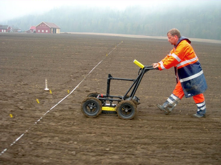
View of the survey site. The remains of the presumed burial mound are visible as slight topographic elevation in the field. The iron rod used for the probing of the ground can be seen on the top of the elevation.

The farmer probed the subsurface by poking manually with a heavy iron rod in the ground. The rod sank approximately 0.3m into the soil and, within a defined area at the elevations' crown, audibly knocked onto hard objects in the subsurface, indicating a layer of densely packed stones, alongside which the rod sank without obstruction deeper into the soil. Archaeologists assumed that the stone layer and elevation could have been caused by an eroded burial mound with central grave. In order to test this hypothesis an archaeological prospection test using magnetic (Reference NeubauerNeubauer 2001; Reference AspinallAspinall et al. 2008) and GPR measurements (Reference ConyersConyers & Goodman 1997; Reference LeckebuschLeckebusch 2003) was conducted in a square of 50m side length centred on the crest of the elevation. Magnetic susceptibility measurements conducted with a handheld Kappameter (SM-30) on several of the erratic stones gave readings 36 times higher than the surrounding soil, suggesting clear detectability of similar stones with the magnetic prospection method.
The fieldwork
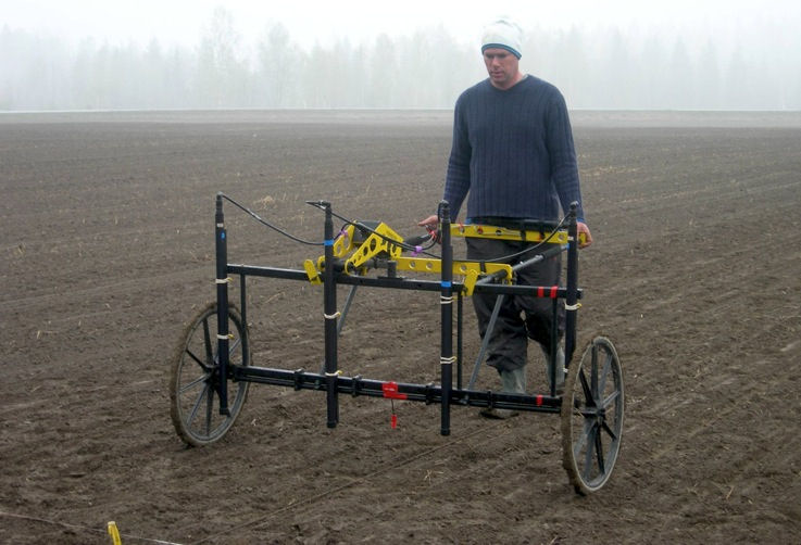
The direction of the GPR profiles was aligned with the furrows in the field in order to reduce measurement noise. Within six hours three operators surveyed the area with a 500MHz single channel GPR system (Sensors & Software NogginPlus) using 0.25m profile spacing and 25mm inline measurement spacing (Figure 2). For orientation, 50m long marking lines were placed with 1m separation on the ground. The measurements were triggered by an odometer wheel attached to the GPR cart. Subsequently the same area was surveyed within 45 minutes using a Förster magnetometer system (FEREX4.032 STD) consisting of four gradiometer probes mounted with 0.5m horizontal spacing on a non-magnetic cart (Figure 3). The lower sensors were fixed approximately 0.2m above the ground. Orientation lines were placed with 2m distance on the ground and the inline sampling interval was 0.1m.
Georadar survey along 50m long profile lines using a 500MHz antenna system mounted in a cart. The edge of the survey area marked with a fibre glass tape measure is visible in the photo. Profile lines were spaced with 1m distance on the ground.

Magnetometer survey using four gradiometer probes with 0.5m spacing mounted on a non-magnetic cart.

Data and results
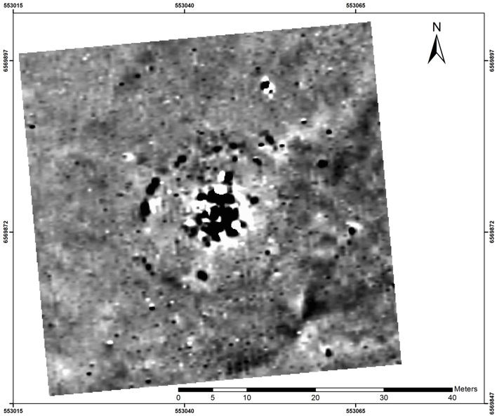
The resulting magnetometer data (Figure 4) showed a central region of approximately 10m diameter consisting of numerous objects with strongly increased magnetisation. This anomalous region is interpreted to be caused by stones having a high magnetic susceptibility, similar to the stones sampled at the surface. Within the measurement area further individual, small-scale anomalies indicate the presence of stones which have been ploughed up or displaced. The large central magnetic anomaly is interpreted as stone packing over a central grave surrounded by a circular structure, presumably a trench around the mound. A number of small dipole anomalies indicate iron objects. Less distinct variations in the magnetic field to the east and south-east of the mound suggest the presence of further structures of probable archaeological interest.
Magnetic data image showing a central anomalous region caused by the layer of packed stones, as well as a circular structure surrounding the centre caused by a trench.

The analysis of the GPR data, which was processed into depth-slices, confirms the interpretation of the magnetic prospection data with more detailed information. From approximately 0.3m depth onwards reflections from the central stone packing are visible in the data. A distinct ring shaped structure of 2–3m in width surrounds the central stone layer at the same distance at which the circular anomaly was observed in the magnetometer data (Figure 5). Numerous light coloured blotches with 2–3m diameter became visible in the data, both within and outside of the circular trench, suggesting the presence of pits or graves, some of which even show internal structure. Other more diffuse GPR anomalies suggest that remains of buildings and other constructions can be expected in the subsurface. In particular, in the south-western region of the survey area a large rectangular structure partly covered by the GPR measurements indicates the remains of a larger construction. An animated display of the depth slices can be seen by clicking on Figure 5.
Georadar depth-slice image showing a circa 0.1m thick data slice at approximately 0.5m depth. The circular trench can be clearly seen, as well as numerous pits or graves inside and outside of the trench. Click to see the animated display of depth-slices (note: this may take time to load).

This test survey obtained data of high quality in a short span of time, demonstrating a successful application of the combined GPR and magnetic method. The archaeological hypothesis that an eroded grave mound had been located at this site was confirmed since it is the only plausible explanation for the observed anomalies. The data suggests the presence of an entire grave field and remains of other constructions (Figure 6). Most importantly, the combined data shows that this archaeological site is seriously threatened by destruction through ploughing: several, probably dislocated, stones can be seen in the magnetic data; the shallow GPR depth-slices show that the top of the stone layer is located at the same depth at which clear plough-marks can be seen and the eastern and southern part of the circular trench surrounding the central grave have suffered more strongly from erosion than the other parts. A large-scale geophysical survey of the entire site and protective measures or a rescue excavation would be recommended for this site.
Interpretation of all georadar depth-slice images.

Acknowledgements
The presented survey was conducted with the help of Pär Karlsson and Bengt Westergaard from UV Teknik, Swedish National Heritage Board. The project was organised and partially funded by Vestfold County administration and Midgard Historisk Senter in cooperation with the Norwegian Directorate for Cultural Heritage. Many thanks go to Joel Boaz, Trude Aga Brun, Lena Fahre, Anitra Fossum and Christer Tonning for their excellent preparation and support.
A full survey report in PowerPoint format is available from the Swedish National Heritage Board, UV Teknik, or the Vestfold County Administration online at: http://www.vfk.no/doc/kulturminnevern/geofysikk/Odberg_site_2/zip/odberg_site_2.zip.