

INTRODUCTION
Lochbrow, in Dumfries and Galloway, Scotland, is the location of a complex of prehistoric archaeological sites, which were first identified as cropmarks on aerial photographs in the 1980s and 1990s. The sites recorded include a timber cursus monument – that is, a monument of Early Neolithic date recorded in cropmarks as alignments of post-pits and interpreted as a long enclosure defined by free-standing timbers.Footnote 1 Also recorded were one certain and one probable Late Neolithic or Early Bronze Age timber circles, recorded in cropmarks as incomplete circuits of postholes, as well as one, possibly two, Bronze Age round barrows. Until the present research, very little work had been undertaken at this site, although the monuments at Lochbrow were discussed by the Royal Commission on the Ancient and Historical Monuments of Scotland (RCAHMS) in its Eastern Dumfriesshire survey.Footnote 2 Study of the aerial photographs and a site visit as part of doctoral research had identified Lochbrow as worthy of further investigation;Footnote 3 the patchy formation of cropmarks suggested that more features might remain to be identified in the areas not conducive to cropmarking, while the striking nature of the landscape location hinted at interesting relationships between the monuments and topography.
The Lochbrow location had also been identified as being of potential interest through predictive modelling and spatial analyses.Footnote 4 Therefore, the Lochbrow Landscape Project was formed to investigate and better understand the sites and landscapes at Lochbrow. The aims of this project were to:
-
∙ investigate and clarify the nature and character of the sites and monuments recorded at Lochbrow;
-
∙ explore the relationship between the sites and their layout in the landscape;
-
∙ study the wider location to investigate the possibility of additional activity, not recorded as cropmarks;
-
∙ investigate long-term relationships to place and the use and development of the landscape; and
-
∙ demonstrate the value of a methodology integrating different research techniques for the investigation of a complex site.
A pilot survey was undertaken in 2010 as well as a series of short field seasons from 2011 to 2015, during which geophysical survey was employed alongside experiential survey, soil coring and re-assessment of the aerial photographs. The project was small scale in terms of personnel, and fieldwork was undertaken by the authors together with small groups of volunteers, both from the local area and from the universities of Glasgow, Aberdeen and York. This paper will outline some of the outcomes of the work conducted by the Lochbrow Landscape Project and some preliminary interpretations.
LOCHBROW: LOCATION AND CONTEXT
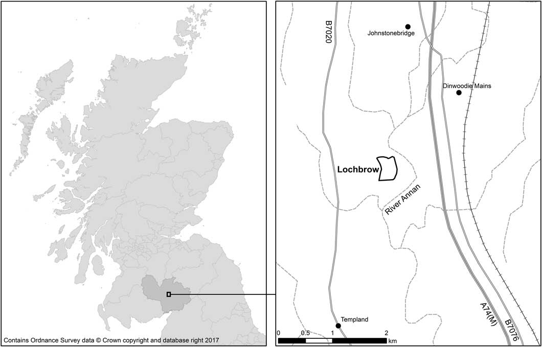
The study at Lochbrow is centred at national grid reference NY 09514 89350, approximately 2.5km south of the village of Johnstonebridge and 8.5km north west of Lockerbie, Dumfries and Galloway (fig 1).
Location of study area. Photograph: Ordnance Survey data © Crown copyright and database right 2016
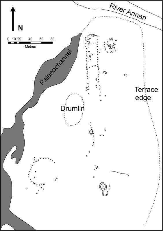
Lochbrow is situated on arable land west of a meander of the River Annan, in an area that is now fairly flat with gentle changes of topography, which makes the large palaeochannel bisecting the northern part of the site and the steep terrace slope towards the river (fig 2) all the more pronounced when viewed from the ground. The archaeological remains are located between the palaeochannel and the steep terrace slope.
Transcription of the cropmarks recorded at Lochbrow showing the distinctive topography. Source: the authors
The cropmarks were first recorded during aerial surveys by RCAHMS in 1988, 1989 and 1992, the cropmarks recording slightly different features each year and the full picture building up with each subsequent aerial survey.Footnote 5 Prior to the present study, research at Lochbrow comprised the inclusion of its timber cursus on a distribution map of Neolithic monuments in southern Scotland,Footnote 6 discussion by BrophyFootnote 7 and MillicanFootnote 8 and a site visit by Millican.Footnote 9
The current use of the land at Lochbrow is dairy farming; the land is categorised as non-prime agricultural land that can support a moderate or narrow range of crops such as cereals, grasses and fodder.Footnote 10 The soils are primarily eutric cambisols typical of alluvial environments with undulating or hilly terrain.Footnote 11 The field supported silage and was being grazed at the time of surveying. The solid geology of the area is the Corncockle Sandstone Formation, a Permian, fine- to medium-grained, well-sorted, red quartz sandstone with large scale Aeolian cross-bedding.Footnote 12 This is overlain by superficial deposits of the Pleistocene Age Kirkbean Sand and Gravel Formation of between 4m and 10m in thickness,Footnote 13 which forms a terrace to the west of the river.
The monuments at Lochbrow recorded within this context range in date from the Early Neolithic to the Bronze Age and include a timber cursus, timber circles and round barrows (see fig 2). The earliest is the timber cursus, an Early Neolithic monument form (dating to between c 3900 bc and 3600 bc) exclusive to Scotland, with around twenty-nine definite or probable examples known to date.Footnote 14 Timber circles are more common phenomena found throughout the British Isles, dating to any time between the later Neolithic and early Bronze Age, from around 3300 bc to 1500 bc.Footnote 15 Finally, round barrows are Bronze Age funerary monuments, found across the British Isles.
The timber cursus monument at Lochbrow is defined by post-pits and is at least 175m in length by approximately 20m in width. Each post-pit is interpreted as originally holding a free-standing timber. Only the northern, V-shaped, terminal of the cursus has been recorded, and the cropmarks suggest that the cursus may widen slightly to the south. One internal division has been recorded within the northern section of the cursus, around 57m from the northern terminal. Of the two timber circles, the probable example is located only around 10m to the east of the cursus terminal. The cropmarks are not clear enough to make a definite interpretation and, unfortunately, the geophysical surveys have not been able to shed any further light on this feature. Therefore, its interpretation as a timber circle must remain uncertain. The second timber circle is more certain and has been clearly recorded as cropmarks located approximately 75m south west of the south end of the cursus. At 48m across at its widest extent, this example is one of the largest recorded in Scotland.Footnote 16 A round barrow and a small section of curving ditch, which may be part of a second barrow, appear to lie on the line of the cursus to the south.
METHODS: EXPERIENTIAL AND GEOPHYSICAL SURVEYS
As a means of investigating this prehistoric complex further, both geophysical and experiential surveys have been undertaken at Lochbrow. The geophysical survey aimed to explore the potential extent and survival of the prehistoric landscape, while the experiential survey was focused on exploring the landscape setting. To the authors’ knowledge, geophysical survey has not been attempted before at the site of a timber cursus, though this method has been employed at bank and ditch type cursus monuments,Footnote 17 and so the viability of this method for investigating this monument type was unknown. In part, this was due to the difficulties of dealing with predominantly pit-defined archaeology, but also to the relatively limited attention that has been afforded to timber cursus monuments as a whole.Footnote 18 Nevertheless, as the formation of cropmarks at Lochbrow is patchy, it was considered that geophysical survey may be able to fill in some of the gaps in the recorded cropmarks as well as provide additional information about the nature of the known features and their survival.
Experiential survey
Embodied or experiential surveys have become popular over the last few decades and have stressed the importance of particular visual and spatial relationships between monuments and other landscape features.Footnote 19 They have demonstrated that locations were carefully chosen and landscape was an important part of the construction, experience and use of these monuments.Footnote 20 Such studies, though, have focused predominantly on highly visible, monumental structures such as chambered cairns and other megalithic monuments.Footnote 21 Less commonly considered are the locations of cropmark sites where little survives above ground with which to engage. A small number of studies, though, have demonstrated the value of applying experiential methods to cropmark sites.Footnote 22 Indeed, an earlier study of Lochbrow by one of the authorsFootnote 23 suggested that Lochbrow and similar sites in the region were more closely tied to their local environment and location than to the more distant views that tend to be emphasised by other experiential studies. This preliminary research indicated that there was much to be gained from a more detailed study. Therefore, the experiential survey employed at Lochbrow built upon this work, focusing less on long-distance views of landscape features and more upon the topographic and local landscape context. It drew inspiration from the work of Hamilton et al,Footnote 24 whose methodology included marking out the predominantly cropmark archaeology on the ground prior to conducting the experiential survey.
Geophysical survey at Lochbrow
Fluxgate gradiometry and electrical resistance surveys were carried out across the field in which the cropmark features were recorded at Lochbrow. These methods are well documented as being successful in detecting anomalies of archaeological significance, given favourable environmental conditions. The Lochbrow landscape, however, was challenging given its superficial glacial geology and the more recent agricultural exploitation, both of which have helped to obscure the more subtle archaeological features. The surveys were carried out at a high resolution (0.5m×0.5m samples for resistance; 0.5m×0.125m for gradiometry) due to the size of the post-pit features being sought. In all, an area of c 3.3ha of resistance and c 13ha of gradiometry was collected.
Gradiometry was collected systematically across the whole field, while resistance, being the slower technique, was used to target the main areas of interest – the cursus and associated features known from aerial photography. By primarily targeting already known features, the resistance survey risked confirmation bias, rather than potentially discovering new features not known from aerial survey. It would have been desirable to have completed a full survey of the field with both methods to avoid this. Nevertheless, a remarkably large area has been completed within the scope of the six seasons, demonstrating that meaningful surveys can still be carried out despite short seasons and small numbers of volunteers with varying degrees of experience.
It is clear from both sets of results (fig 3) that they are strongly influenced by the geology of the gravel terrace (the strong north-east to south-west trends and strongly dark and light patchy areas), complicating the archaeological interpretation of the data. However, it is still possible to see anthropogenic features from various periods within the dataset, though the interpretation must be treated with caution as a result.
Results of (a) gradiometry and (b) electrical resistance surveys. Source: the authors
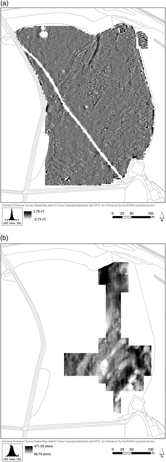
The most obvious anomalies in the gradiometry, viewing at small scale, relate to the geological and topographical features of the site: the course of the relict stream channel running north east to south west across the field, along with a number of sinuous and faint features that most likely relate to glacial activity on the gravel terrace. One particularly large area of differential magnetic response is a large patch just south of, but following the direction of, the channel. This corresponds to an area of higher topography, which was originally thought to either represent a ploughed-out barrow or a possible glacial feature such as a small drumlin. Sedimentological analysis from auger coring showed that the latter interpretation is more likely.Footnote 25
The natural features are also reflected in the resistance survey, which covers one side of the palaeochannel at the northern end, and is represented by a large anomaly of very high resistance. Anomalies of similar strength (both of very high and very low resistance) can also be seen in the lower part of the field. These areas match those dark areas visible in the aerial photography, which unfortunately obscure (or do not produce) cropmarks. While these patches do not appear as such in the gradiometry, faint trends tally with those features, likely to be glacial meltwater channels.
The Lochbrow fields have been subject to deep ploughing in recent history. Faint north–south linear trends in the resistance are likely to reflect this. Traces of older activity, however, are also apparent in certain areas. A small patch of linear anomalies running roughly east–west appear in the gradiometry within the small area surveyed in the adjacent field, which lies on the same plateau. This most probably represents later or post-medieval ridge and furrow (6m spacing), which can – with the eye of faith – be extrapolated in certain areas into the main field, and aligns with a highly magnetic rectangular anomaly in the far north of the field unlikely to represent part of the prehistoric complex. This indicates that deep ploughing in the main field is likely to have had a serious impact on the visibility or survival of archaeological remains.
With this in mind, it is heartening that there has been some success in capturing archaeological anomalies of likely prehistoric date. The geophysics was successful in detecting all of the known features from the aerial survey. However, in order for the surveys to prove useful, they needed to detect features not already prospected. In this, the survey was successful in a few areas: in discovering a small number of new features, and also in extending the area of known ones.
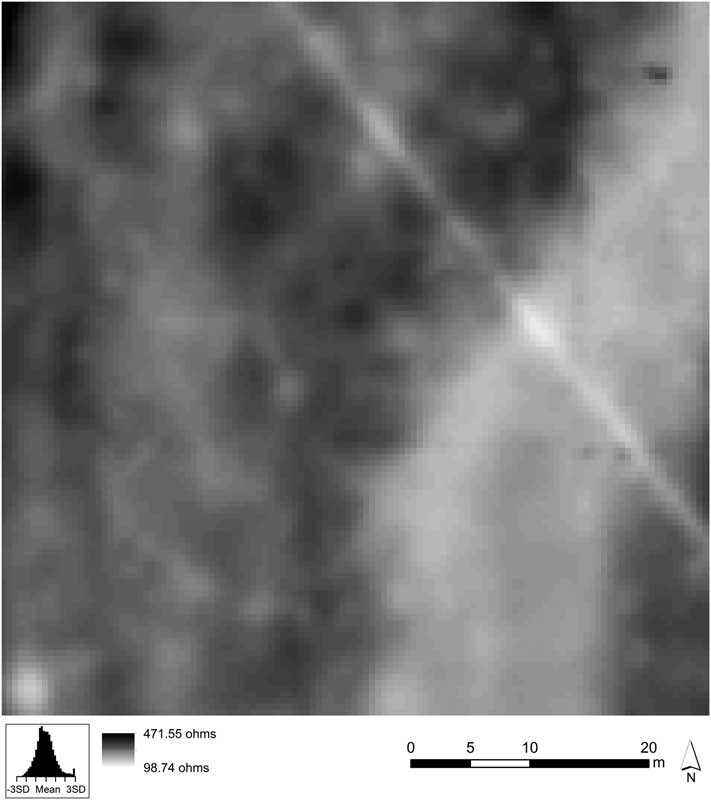
Postholes, which were likely to form a large part of the monument complex, can be difficult to capture with geophysics, but in using a high resolution, the resistance survey captured clearly a large part of the timber circle (fig 4). Unfortunately, the change in geomorphology coinciding with part of the circle means that the survey was unable to identify further postholes in this area, and so a complete record is not possible. This is also reflected in the cropmarks. For the timber cursus itself, the surveys were less successful in capturing postholes, but rather identified a few faint linear features following the course of the cursus, which might indicate ditches or banks. If correct, this interpretation is significant as it has previously been speculated that the apparent association of later monuments with earlier timber cursus monuments could suggest the presence of a slight earthwork element.Footnote 26 The timber and earthwork cursus monuments excavated at Holywood North,Footnote 27 around 17km south west of Lochbrow, could, however, suggest another explanation. Here, a timber cursus pre-dated, and was later replaced by, an earthwork cursus. While this could suggest that the features identified at Lochbrow represent the remnants of a later earthwork cursus, this seems unlikely for a number of reasons. The probable features identified at Lochbrow are on a much smaller scale than the ditch and bank at Holywood North and, significantly, have not been recorded in the cropmarks. It is difficult to explain why the postholes of a timber cursus would survive sufficiently to form cropmarks and not the ditch or bank of a substantial earthwork cursus. Additionally, the linear features do not form a complete circuit (though this may be more a feature of the geomorphology of the site) and instead appear to follow the line of the postholes. It is the authors’ view, therefore, that the probable features identified at Lochbrow are very slight and unlikely to represent an earthwork or ditch-defined cursus similar to that at Holywood North. Instead, they are more likely to represent an upcast bank or slight ditch connected with the timber posts of this monument. At no other excavated timber cursus monuments has such a feature been identified, but, given the plough-truncated nature of all excavated timber cursus monuments, may potentially have been removed by ploughing. Given that post-burning has been recognised at some of these excavated timber cursus monuments,Footnote 28 it was suggested that some of the timber posts at Lochbrow may also have been burnt. Gradiometry should have shown this clearly in the results. However, as discussed above, the combination of agricultural debris and complex geomorphology means that any burnt postholes, if present, are extremely difficult to identify, and so this question remains unresolved.
Electrical resistance results showing the timber circle as low resistance anomalies. Source: the authors
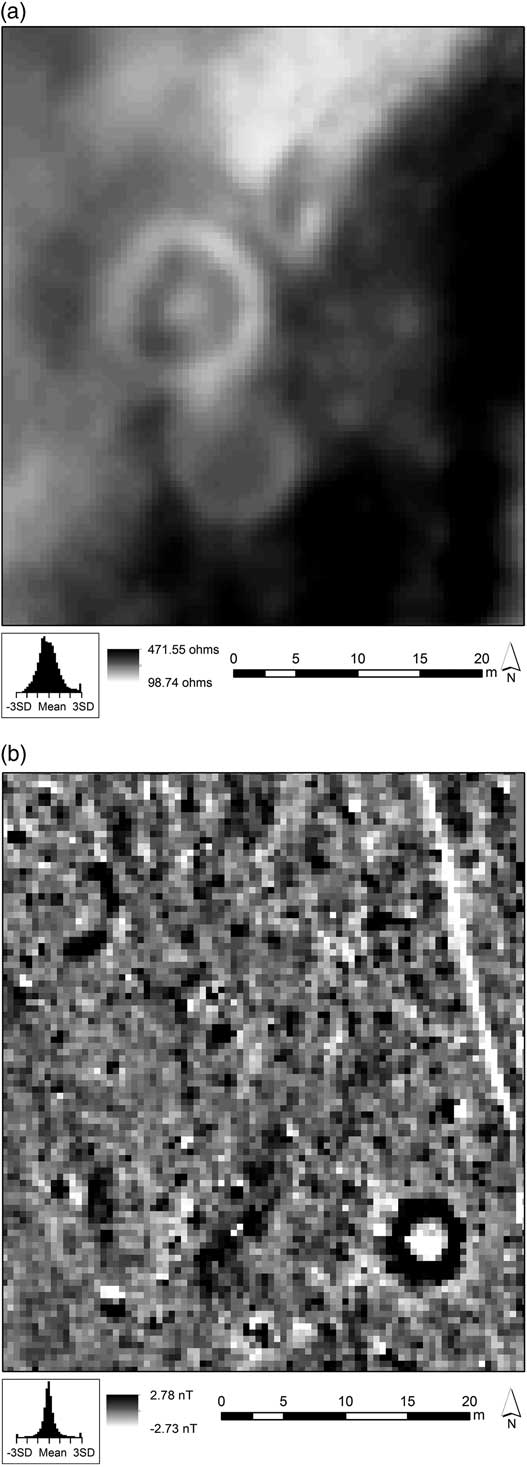
Another significant result is the barrow complex in the southern part of the field, visible as cropmarks. Without the aerial transcription, it would have been very difficult to spot the barrows in the gradiometry results. Nevertheless, there are faint responses that correspond with their location. The barrows are very clear in resistance, however, showing as circular ditches and, in one instance, an anomaly marking the centre, probably the central burial (fig 5a). In these results, the resistance actually appears to extend the complex, showing a possible additional barrow of poor preservation adjacent. It is curious, then, that it is in the gradiometry that one definite and one partial new barrow were identified in the northern part of the field (fig 5b). It is unclear whether this is due to differences in the geomorphology, making anomalies stand out more clearly in this part of the field, or to anthropogenic activity during the use of the northern barrows. However, the fact that the outer ditches show up as strong magnetic anomalies implies that the fill of the ditches likely contains burnt material.
The (a) southern round barrows showing as low resistance features, and (b) northern barrow showing as magnetic anomaly plus probable partial barrow to the north west. Source: the authors
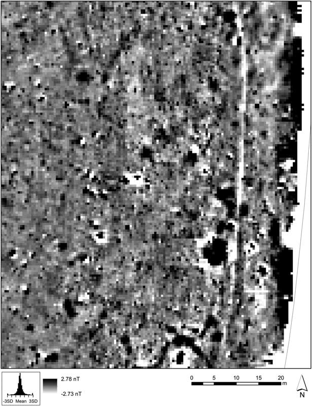
Amongst the complex palimpsest of responses, it is likely that there are many other features of archaeological significance. One area of promise is the area to the east of the southern barrow complex (fig 6). A number of unusual anomalies are present in both sets of survey results, but they do not correspond with any obvious monument forms. On re-examination of the aerial photo, they are partially visible as cropmarks, but are largely obscured by geomorphology and tree cover.
Magnetic anomalies of archaeological significance in the south east of the study area. Source: the authors
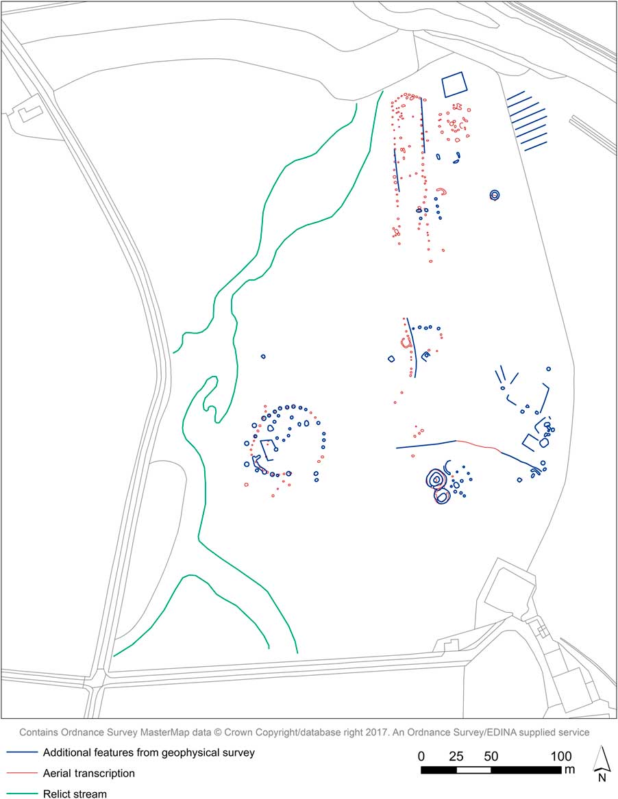
This has highlighted one of the main benefits of this survey: in analysing the geophysics results, it has been possible to return to reassess the original aerial transcriptions. Once anomalies were recognised as known features, it was then possible to see additional similar features in the data, which, once spotted, could actually be seen, albeit very faintly, in the aerial photos. However, without field investigation, many of these anomalies cannot be verified. The interpretation presented (fig 7) is rather conservative as a result of the complexity, and it is likely that many more features remain to be discovered.
Interpretation of results showing the original cropmark transcription alongside additional information gained from geophysical survey. Source: Survey data and aerial transcription the authors; map Ordnance Survey data © Crown copyright and database right 2016
LOCHBROW: MONUMENTS AND LANDSCAPE
One of the aims of the project is to understand the archaeological sites at Lochbrow within their wider landscape context. It has previously been notedFootnote 29 that the Lochbrow monuments are located within a distinctive topography (see fig 2). The monuments are positioned on a level part of the gravel terrace above the floodplain of the River Annan, the terrace defined by fairly sharp, steep edges. A palaeochannel cuts through this terrace on a roughly north-east to south-west orientation. This is likely to be a late- or post-glacial feature rather than an abandoned tributary channel of the Annan,Footnote 30 so would not have been an active stream contemporary with the monument complex. Nevertheless, the area would probably have been damp or marshy, and today forms a very distinctive (and deep) topographical low. This feature constrains the northern end of the terrace, forming a curved end. The cursus and possible timber circle were positioned at this narrowest point, and the cursus terminated close to this northern edge, the form of the cursus terminal perhaps mirroring the shape of the terrace edge.Footnote 31 The cursus then follows the orientation of the eastern terrace edge, which drops off very sharply to the floodplain below, marking a very distinct change in elevation. To the centre west of the cursus is the small drumlin, which forms a distinct topographical high on the otherwise relatively level part of the terrace. The large timber circle to the south west of the cursus is positioned close to the western terrace edge, overlooking the palaeochannel.
This setting is important to our understanding of the monuments of Lochbrow. The highs and lows of the topography, and the position of the monuments in relation to it, provided constraints and opportunities for:
-
∙ the way in which the monuments could have been approached and used;
-
∙ the activities that could have taken place on the site in the past; and
-
∙ how the monuments may have been experienced and understood.Footnote 32
There are indications, too, that the form of these natural features may have influenced elements of the form of the monuments.Footnote 33 Therefore, with this project, the authors wanted to investigate this relationship further, to develop a better understanding of the relationship of the sites to their landscape setting, and also to consider the social, lived and experienced spaces of Lochbrow’s monuments and landscapes as a means of enriching their interpretation.
One of the first steps towards developing a better understanding of the landscape and topography, and the place of the monuments within, was simply to mark out the location of the archaeology on the ground with flags, using a differential GPS and coordinates taken from the interpretation of the aerial photographs. The cursus, timber circle and barrows were marked out in this way for the first time in 2013, and then each subsequent year. As comparison between the aerial photographs and geophysical results had shown a good correlation between the aerial transcription and buried archaeology identified by the geophysics, the authors could be confident in the location of the features flagged out on the ground. By doing this, it became possible to place the monuments more accurately while in the field, to move within and around the known monument boundaries, and to consider the interplay of monuments and topography while on the ground.Footnote 34 This method has helped to materialise the archaeology in an otherwise empty field and has highlighted elements of the monuments’ morphology and landscape location that were not obvious from the transcribed cropmarks.
Firstly, the western side of the cursus at the terminal end was positioned a very short distance from the break of slope of the palaeochannel. As there is a considerable amount of level ground to the east of the cursus, it seems likely that it was a deliberate choice to place the cursus here. Doing this may have emphasised the height of the timbers when viewed from the west, but also would have created a very definite edge to the area at the west of the cursus. This could support the suggestion that the distinctive topography around the monuments at Lochbrow was employed to demarcate the limits of activity here.Footnote 35 A similar relationship was observed between the large timber circle and the edge of the palaeochannel, with the timber circle positioned very close to the western edge of the terrace at a slight bend in the palaeochannel. Indeed, the western arc of the timber circle and the edge of the terrace seem to mirror one another when viewed from the east, something that could suggest that the circle was positioned here to take advantage of the natural topography. Certainly, there is a legitimate question as to why the circle is so close to the terrace edge when there appears to have been plenty of level ground further away from the edge of the terrace on which to build. In a similar manner to the relationship of the cursus to the palaeochannel, this positioning may also have emphasised the height of the timbers when viewed from the west, and may suggest that the local topography was used to enhance or emphasise this section of the monument. The relative dating of the monument forms, with the cursus monuments and timber circles likely built several hundreds or even thousands of years apart, means that we can draw no direct connections between the locational choices of the cursus and the timber circle.
When the cursus boundary was marked out, the relationship between the cursus and drumlin was also highlighted, and it became obvious that the western side of the cursus was constructed close to the base of the drumlin. This means that, depending upon the height of the timbers, it was possible that anyone standing on the drumlin could see into the cursus. As well as enclosing those within, boundaries can also exclude, blocking both visual and physical access. It is interesting, then, that at Lochbrow the cursus was positioned close to a natural feature that potentially allowed individuals to see into the monument. As with the observed relationships with the palaeochannel, there is space upon the terrace to position the cursus further east, at a greater distance from the drumlin, so this relationship must have been a deliberate choice. However, as well as potentially providing a certain level of access, this feature also creates an additional barrier or boundary, preventing visual access at least from the west. The palaeochannel further to the west creates another boundary; it is a very distinct feature that separates one part of this field from the other. Could we be seeing the use of the natural topography to create different levels of access, to form viewing platforms – or perhaps both?
In contrast, the latest monuments (the barrows) within this group of sites appear less influenced by the topography and landscape. Instead, their location can be suggested to be influenced more by the earliest monument known at Lochbrow, the cursus. The barrows visible on aerial photographs appear to lie more or less on the axis of the cursus, something that was confirmed when walking down the length of the flagged-out cursus. It was found that when walking down the centre of the cursus one is directed towards the two round barrows in the south of the field. Considering that they may have been built as long as 2,000 years after the cursus, then perhaps the resistance results provide a clue of upstanding features that may have allowed them to be positioned with such accuracy.
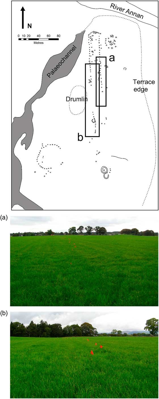
The process of marking out the boundaries of the monuments also revealed elements of their morphology that had not previously been noted. Firstly, the cursus sides appear to curve inward slightly where they meet the single partition at the north. This is a characteristic noted at other timber cursus monumentsFootnote 36 and could suggest that there was more than one phase to the construction of the cursus at Lochbrow, perhaps beginning as a timber enclosure in which the partition functioned as the southern terminal, which was later expanded to the south. Indeed, phased building is also suggested by the fact that the cursus boundary is not straight and, in fact, could be described as being distinctly wobbly or irregular (fig 8). This may indicate that the cursus was constructed in sections – again, something that has been suggested at cursus monuments elsewhere.Footnote 37 In addition, the cursus boundary could be seen to take a distinct diversion around the natural drumlin in the centre of the river terrace (see fig 8). The western side of the cursus passes very close to the drumlin and appears to respect it, with the west side curving round the drumlin and slightly to the south. This curving section means that anyone at the south end is slightly offset from anyone at the north end, and this is likely also to have affected visibility within the monument; with large timber posts in place, these timbers are likely to have blocked the view from the north end of the cursus to the south end. Indeed, when at the north end, the curving section almost seems to cut across the width of the cursus and to create the effect of a terminal. As one walks south down the cursus, the monument begins to open out again. Together, this suggests that the cursus boundaries and divisions were used to create particular effects and perhaps to create smaller enclosed spaces within the larger monument.
Elements of the cursus’ morphology made obvious when marked out on the ground: (a) looking south along the eastern side of the marked-out cursus boundary (red flags), the irregular nature of the cursus boundary can be clearly seen; (b) looking north along the western side of the cursus, the flags show the distinct curve of the boundary. Source: the authors
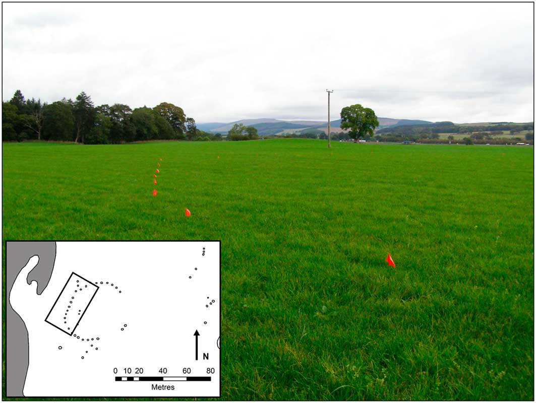
Turning to the timber circle, when marked out on the ground the flattened aspect of the western side of the timber circle became clear (fig 9). This can be observed on the aerial transcription, but is an even more distinct feature on the ground, though this characteristic is not obvious from every vantage point. As a regular circle is relatively easy to mark out with peg and string,Footnote 38 this must have been a deliberate choice. Why this might be the case is more difficult to answer. It may be a function of the mirroring suggested above, though other explanations, including the intended uses and functions of the circle, are also likely.
The flattened aspect of the western side of the timber circle marked out by red flags. Source: the authors
By flagging out the archaeological features on the ground, it has been possible to begin to get a better understanding of the morphology of these sites, their relationships to landscape and where they sit in relation to the distinct topographical features at Lochbrow. It is possible to suggest that the cursus and timber circle were very closely tied to their landscape setting. That setting may have been employed to emphasise certain elements of the monuments, to restrict or control access and to define areas of activity. In contrast, the barrows on the southern axis of the cursus, and perhaps the additional barrows identified through the geophysics, seem to have been placed in relation to the earlier activity at this location. Further, the monument boundaries themselves were used to create particular effects and influence the experience of being within the monuments.
Marking out the archaeology also allows us to experience the scale and dimensions of these monuments and think about those dimensions in relation to an individual. For example, although the south-west timber circle is one of the largest in Scotland,Footnote 39 when only two or three individuals were standing within it, it felt to the authors as if it were a much smaller and more intimate space than the cursus, even if just the northern section were being considered. While this is clearly a very subjective observation, it is useful when considering the way in which these sites may have been experienced and how ceremonial practice changed over time – a change perhaps from larger ceremonial practice of the earlier Neolithic to smaller, more intimate activity during the latter part of the Neolithic or Early Bronze Age. Marking out the archaeology also serves to transform something abstract into something slightly more concrete, and is particularly relevant for understanding cropmark sites where no features survive above ground. Of course, large timber posts rather than flags would have defined these monuments, and also erosional processes will have affected the topography to some extent, but it does help to begin to transform and enrich our thinking. Sites and monuments are more than their ground plans, and this method is useful as a means of helping us to think about the experience of being within and around these monuments and to develop a social understanding of the sites and landscapes at Lochbrow.
CONCLUSIONS
In summary, research at Lochbrow has fulfilled many of the initial aims of the project, namely to add to the picture already known from cropmarks and to explore the character of the sites at Lochbrow and their relationship to landscape. While it has been challenging to interpret the results gathered throughout this study, the process of interpretation has demonstrated the value of employing a number of different research methods (such as cropmark interpretation and geophysical survey) at one site, where the different methods often inform and enhance the interpretation of the results derived from other survey techniques.
Geophysical survey has revealed additional features to those that were already known, providing evidence of the longevity of activity in this location, with as much as 2,000 years between the earliest and latest datable activity, and perhaps more depending upon the date of the new features recorded by geophysical survey. This activity appears to be more complex than initially revealed as cropmarks, and may also suggest that comparable clusters of prehistoric sites elsewhere could be similarly complex and long lived. This is perhaps not surprising as it is well recognised that cropmarks do not always reveal the full picture of archaeological activity.Footnote 40 However, it may also suggest that, at Lochbrow and perhaps elsewhere, the construction of a cursus had an impact on the significance of the place that lasted many generations. Archaeologically, this seems to have led to the creation of further monuments on and around the location of this earliest monument. In many comparable cases,Footnote 41 it is possible to suggest that later monuments were positioned with reference to the earlier cursus.
In this respect, the suggestion of an additional earthwork component (ditch or bank) for the cursus at Lochbrow is significant, particularly as such a feature has been suspected, though not confirmed elsewhere.Footnote 42 While the presence of this feature cannot yet be definitively proved, it adds weight to the suggestion that at least some timber cursus monuments may have comprised more than standing timbers. This need not be more than upcast from the digging of postholes, which would create a small earthwork element. Certainly, at Lochbrow this feature was not substantial enough to influence the formation of cropmarks. Other than the later earthwork cursus at Holywood North,Footnote 43 which was on a much larger scale than that suggested at Lochbrow and, therefore, is not considered comparable, no similar feature has been identified at any other cropmark or excavated timber cursus monument. Such a feature, though, would help to explain why some later sites constructed on and around earlier cursus monuments appear to be positioned with reference to the timber boundaries of cursus monuments with a degree of accuracy.Footnote 44 It is, therefore, perhaps significant that both the timber circles and the multiple barrows now identified at Lochbrow were constructed around the location of the cursus, but not within it, which again hints at the possibility of the continued survival of some feature connected with the cursus long after the timber posts decayed or were burnt.
Ground-based interpretation that draws upon marking out the location of the known features on the ground suggests that the timber cursus and large timber circle were very closely related to their landscape setting; the natural topography would emphasise the boundaries of, and create different levels of access to, the monuments themselves. Irregularities in the boundaries of both the timber cursus and timber circle further suggest that the forms of these monuments and their positions in the landscape were employed to affect the experience of those within these monuments. More widely, this adds further weight to the suggestion that such monuments were closely tied to their location and context.Footnote 45 In fact, it indicates an intimate connection with context, one in which the topography and landscape played a part in the way in which the monument could be approached and experienced. In essence, we must consider the topographic setting to be an extension of the monumental form. A similar relationship with topography is also indicated at the large timber circle, an aspect of timber circles that has not been considered to any great extent. Therefore, further investigation of this facet of timber circles and their context more generally may prove fruitful.
Therefore, the research conducted by the Lochbrow Landscape Project has succeeded in enlarging the picture of the prehistoric sites and monuments both at Lochbrow and more widely. The results, however, raise many questions and further work will be required to make sense of the data and information collected. More detailed analysis of both the geophysical results and the cropmarks recorded on aerial photographs may clarify the features already identified or reveal more detail. More in-depth analysis of the landscape setting and the experiential nature of the monuments may also reveal additional insights into the character and form of this remarkable cluster of sites and the development of the sites and landscapes at Lochbrow.
ACKNOWLEDGEMENTS
The authors are grateful to The Crown Estate, Smiths Gore and Mr David Wilson of Lochbrow Farm for their support of this project. The 2012 and 2013 seasons were supported by funding from the Society of Antiquaries of London, the 2014 season by funding from the University of York, and the 2015 season by funding from the Royal Archaeological Institute (RAI). We would like to thank Liam Herringshaw and Robyn Inglis for their invaluable input on the geology and environment of Lochbrow. The authors would also like to thank all the volunteers: Ron Addison, Jenny Anderson, Judith Archer, Morag Black, Sophia Black, Sophie Boyadjieva, Giles Carey, Julian Carty, students from Dumfries High School, Hayley Graham, Connor Heaney, Kirsty High, Faith Irving, Robert Irving, pupils from Johnstonebridge Primary School, Eileen Kerhouant, Christine Long, Gillian Mellor, Alastair Murgatroyd, Margaret Pool, Natalia Rebollo, Lavinia Vaughan, Gord Wallace, Yi Chung Pan and Nicky Young. Without their hard work, this project would not have been able to achieve so much. Finally, thank you to the anonymous referees for their helpful comments and suggestions.
ABBREVIATIONS AND BIBLIOGRAPHY
Abbreviations
- RCAHMS
-
Royal Commission on the Ancient and Historical Monuments of Scotland



