

How do people form durable cognitive and affective bonds to state territories? How do these place attachments become rigid? Nation-building scholars agree that nation-states can build solidarity amongst the people through identification with a homeland and that people usually conceptualize these homelands along the lines of sacred spaces and co-ethnics (Yiftachel Reference Yiftachel2002; Moore Reference Moore2016). Scholars also acknowledge that homelands can change (Paasi Reference Paasi2000; Shelef Reference Shelef2020), but that process, and the shift in the associated attachments, is undertheorized.
I argue that the flip side of nation-building is what social epistemologists view as “structural ignorance” (Alcoff Reference Alcoff, Sullivan and Tuana2007; Mills Reference Mills1995, Reference Mills, Sullivan and Tuana2007) and that structured ignorance produces rigid place attachments. This ignorance is not merely a lack of knowledge but the active pursuit of non-knowledge or faulty accounts to hold stable the dominant view of an oppressive society (Alcoff Reference Alcoff, Sullivan and Tuana2007, 48). In other words, it is the background knowledge and cognitive mechanisms that filter out discomforting narratives to maintain a dominant view. While Mills, Alcoff, and others develop this concept in the context of white supremacy or patriarchal oppression, I translate its insights to core/non-coreFootnote 1 groups’ dynamics over a disputed territory. From this perspective, the state structures ignorance among the core group about the symbolic significance of the state territory and about the oppression/erasure of non-core groups inhabiting it. This structured ignorance produces particularly rigid attachments. As ignorance underlies all cognition and the sense of self, when non-core groups contest sovereignty over a territory, the contestation not only clashes with attachments but with the ignorance on which the sense of self is based.
In this article, I examine the process of state territorializing practices, structured ignorance, and rigid attachments, through the case of Azerbaijani attachment to the disputed land of Nagorno-Karabakh (NK), which used to be an enclave mostly inhabited by ethnic Armenians in Azerbaijan. NK is now referred to as “Karabagh” in Azerbaijan, which is a much larger territory, where Azerbaijanis have a demographic majority. This blurring distinction and discursive shift from NK — the more neutral term used by the international community following the Soviet name of the former Autonomous Oblast (NKAO) — to Karabagh is part of the broader process of filtering knowledge that I investigate. This article is not an empirical analysis of the NK conflict — although the conflict does interact with the process — but a study of how Azerbaijan structured attachment to NK.
Both Armenia and Azerbaijan have built attachments to NK through their respective nation-building. Armenia also built the symbolic significance of NK for Armenians after the 1915 Genocide and filtered out knowledge about Azerbaijani presence in NK, the ensuing suffering of Azerbaijani Internally Displaced Persons (IDPs) and the ruination of their towns in the seven districts surrounding NK, which were taken by Armenian forces after the first Karabakh war (1988–1994). But as it would take another paper to detail the Armenian structuring of attachments, I bracket it here. I illustrate the intertwined process of nation-building and ignorance-structuring with its byproduct of rigid attachments through the slightly more interesting case of Azerbaijan. Except for the minority of Azerbaijanis who lived there, NK — not Karabagh — did not appear to be a “core” territory to Azerbaijanis when the USSR gave Azerbaijan sovereignty over it in 1921. It was mostly inhabited by a non-core group (ethnic Armenians), and scholars of the region agree that Azerbaijani national consciousness was only emerging at that point (Swietochowski Reference Swietochowski and Suny1996; Saroyan Reference Saroyan1990; Dudwick Reference Dudwick and Suny1996). Yet, a few decades later, NK had become an object of violent attachment. Even after the first Karabakh war, the Azerbaijani government, widely supported by the Azerbaijani population, consistently refused concessions over NK’s status in exchange for the return of the seven adjacent territories, which were inhabited by a majority of Azerbaijanis (International Crisis Group 2005).Footnote 2
While existing literatures offer useful pointers on territorial attachments, it falls short in several respects. Place attachment literature conceptualizes attachment but remains limited to the local level and to attachments mostly derived from positive in-group relationships. The nationalism literature in political geography and a particular strand of ontological security literature, which I build on, specifies frameworks to understand homeland construction and its inculcation to the masses (Anderson Reference Anderson1991; White Reference White2000; Ejdus Reference Ejdus2020). Nevertheless, this scholarship generally does not elaborate on how or why certain territories that technically qualify as “peripheral” (White Reference White2000), territories that do not hold primary sites of significance for the nation or not for extended periods of time, can become “core” territories, especially among the masses. The fields of international relations/comparative politics (IR/CP) either focus on — inherently — sacred places (Hassner Reference Hassner2003; except Toft Reference Toft2003) or on territorial attachments from a behavioral perspective (Goemans Reference Goemans, Kahler and Walter2006) that leaves aside cognitive/affective issues.
I claim that the key to understanding how territories shift from peripheral to core spaces and how people deal with the resulting cognitive-affective contradictions lies in the ignorance that the state structures and that the core group reproduces every day in unselfconscious ways. During the nation-building process, states seek to stabilize their sense of collective self by anchoring it to space (Ejdus Reference Ejdus2020). They employ spatial meaning-making practices that physically and discursively construct conceptions of the state territory and lay the ground for ignorance. Physically, the state can build roads, monuments, and statues (that “project” the core group’s identity on the territory (Ejdus Reference Ejdus2020)), displace or kill non-core groups (Garrity and Mylonas Reference Garrity and Mylonas2024), and destroy their cultural heritage. Discursively, it can draw maps with different names, commission inventories that omit the non-core group’s cultural heritage, censuses that diminish their demographic weight, rewrite official histories about the land and the people, and invent commemorations. The state distills these more discursive practices through several means: textbooks, museums, press, media, and touristic guides (Anderson Reference Anderson1991; Moore Reference Moore2016; Billig Reference Billig1995). Overall, states forge conceptions of the state’s territory and eraseFootnote 3 the presence of the non-core other in it. In this structural process, the other becomes “abject,” or “when the familiar ‘stranger’ is suddenly recognized as a threat” (Kinnvall Reference Kinnvall2006, 52), who cannot be reasoned with, and the land becomes an object of core group attachment.
Importantly, as structural ignorance comes to underlie all cognition and emotions — people misremember events, misinterpret behaviors, feel “misplaced” joy or anger — disrupting it disrupts the stable cognitive environment of the people, and with it, their stable sense of self (or ontological security) (Mitzen Reference Mitzen2006). When non-core groups contest sovereignty, the discomforting narratives that the structure of ignorance was filtering out come to the fore. Hence, people pursue ignorance to preserve their ontological security, perpetuating the structure. The need to preserve structural ignorance reinforces abjection and attachment, which intensify uncompromising stances and exacerbate conflict. The core group is not only now strongly attached to the land, but ceding it to the abject other becomes repulsive.
Through discourse analysis and “practice tracing”Footnote 4 (Pouliot Reference Pouliot, Bennett and Checkel2015), I find that popular attachment to NK strengthened as state territorializing practices structured ignorance about the symbolic significance of NK and the oppression of ethnic Armenians inhabiting it throughout the state-building era, more specifically in the 1960s and 1980s. The 1988–1994 war and the ensuing entrenchment of the structure further exacerbated attachments to NK, which are manifest in the second Karabagh war of 2020, and Azerbaijani attitudes today.
Beyond better understanding Azerbaijani attachment to NK, incorporating structural ignorance into territorial attachment has wider implications. It first helps make sense of “unexpected” attachments and the conflicts they engender. Besides sacred places, how do Israelis become attached to villages/towns formerly inhabited by Palestinians? Similarly, for Greek/Turkish Cypriots in their respective territories, Turks in former Armenian, Greeks, and Kurdish places, or any core group attached to state territories formerly (or still) inhabited by a majority of non-core group members? Conflicts may be intractable not just because people are attached to a disputed territory, but because unmaking the ignorance at the basis of the attachment would disrupt their stable sense of self. Understanding the role of structured ignorance also helps explain variation in attachment; where states structured ignorance to a lesser extent, this type of “unexpected” attachment should be less likely (as, for example, with Iraqis and the Kurdish region in Iraq). More broadly, it sheds light on nation-building; all nation-building processes entail some degree of erasure of the non-core other inhabiting the state territory, and hence some structured ignorance of the erasure and the artificial nature of the nation-state. Digging deeper into how ignorance is structured and what cannot be known would improve our understanding of why we become (rigidly) attached to certain things and not others.
After reviewing existing scholarship on territorial attachments and translating the structural conception of ignorance, I trace how state territorializing practices structured ignorance during the Soviet era, after the 1988–1994 war, and after the 2020 resumption. For each period, I first investigate the practices and then look for an increase in the manifestations of structured ignorance and territorial attachment. Lastly, I reflect on the wider theoretical contributions of incorporating structural ignorance into nation-building and territorial attachment studies.
Place Attachment, Nation-building, Focal Principles, and Empirical Scholarship on NK
Various disciplines have examined attachment to territories in relation to identity and war. Place attachment literature, which draws from urban sociology, humanistic geography, and environmental psychology, defines place attachment as “a bond between an individual or group and a place that can vary in terms of spatial level, degree of specificity, and social or physical features of the place, and is manifested through affective, cognitive, and behavioral psychological processes” (Scannell and Gifford Reference Scannell and Gifford2010, 5). In other words, it highlights different types of units that can form different attachments to different places through different psychological processes (cognitive, affective, and behavioral mechanisms). Nevertheless, as the object of focus often remains at the local level and on positive social ties with other residents, it overlooks how core group members can get attached to distant “national” lands that should technically be associated with an “abject” non-core other.
By contrast, political geographers posit that nation-building often entails building an attachment to the “national” territory, often termed the “homeland.” Similarly, constructivists claim that all homelands are social constructions and that senses of place can be discursively manipulated (Shelef Reference Shelef2020, 10–11; Yiftachel Reference Yiftachel2002). Along these lines, George White’s (Reference White2000) treatment of a people’s sense of place is particularly generative. He highlights three components of territorial attachment: cognitive, or “the roles that [places and territories] play for a nation,” affective, or “the feelings a nation expresses toward them,” and behavioral, or “the efforts a nation undertakes to protect them” or “the tenacity factor” (6). Importantly, senses of the national territory can be manipulated through social interaction. White conceptualizes three levels of significance for territories: core, semi-core, and periphery, and defines these levels depending on the number and variety of sites of primary importance (for the nation) in the territory and how continuously across time the territory held importance (40–41).
In addition to White’s theory, I build on Ejdus’s framework on “ontic spaces” (Reference Ejdus2020), as the latter offers additional tools to link territory and sense of self, and as it examines cognitive-affective dimensions. Material environments can be turned into “spatial extensions of the collective self” (Ejdus Reference Ejdus2020, 2), through “introjection” or the discursive linking of the environment to the self-narrative and through “projection” or “the extrapolation of the self onto the material environment” (Reference Ejdus2020, 28). I extend the analysis to how masses, rather than states, develop attachments to these spaces.
Lastly, Goemans’s rationalist theory (Reference Goemans, Kahler and Walter2006) more abstractly argues that people get attached to some territories and not others because territorial specification helps define who defends what and enforces punishment for cheaters (27). This is a “behavioral” approach to attachment — people are not affectively attached to the territory but will defend it at all costs because of a long-term incentive structure. Nevertheless, cognitive and affective dimensions of attachment have significant ramifications, and my theory improves our understanding of key issues sidestepped by rationalist theories: why would people take for granted a delimitation imposed by a former colonial oppressor, how do people reconcile the use of contradictory principles (when leaders change the justification for what counts as the homeland), why do people “defend” a land that is mostly inhabited by a non-core group?
Turning to empirical scholarship on the NK conflict, the literature overlooks Azerbaijanis’ attachment to NK. Although some scholars mention the importance of the conflict for each country’s nation-building (Minasyan Reference Minasyan2017), most studies that investigate the causes of the conflict (see Ayunts et al. (Reference Ayunts, Zolyan and Zakaryan2016) for an overview), highlight regional/international, military factors in the escalation to war (Davtyan Reference Davtyan2024), domestic regimes (Ayunts et al. Reference Ayunts, Zolyan and Zakaryan2016) or a mix of both (Broers Reference Broers2015). I bracket this vast literature on the conflict and build on analyses of hostile rhetoric and collective memory (Sahakyan Reference Sahakyan2023; Garagozov Reference Garagozov2016), to link dehumanization to territorial attachment.
Overall, this article reflects on how non-core territories become core to the nation from the perspective of the masses, and on how people reconcile potential incongruences while maintaining their ontological security. Turning to structural ignorance is particularly fruitful in that respect.
Translating Structural Ignorance to Territorial Dynamics
Drawing from the epistemology of ignorance literature (Mills Reference Mills1995, Reference Mills, Sullivan and Tuana2007; Alcoff Reference Alcoff, Sullivan and Tuana2007), I translate a structural conception of ignorance, generally used to explain white supremacy and patriarchal oppression, to the dynamics between core and non-core groups over territories. With this move, I posit additional connections between ignorance, attachment, and ontological security.
As developed in the social epistemology literature, structural ignorance is not merely a lack of knowledge, but the active pursuit of non-knowledge to hold stable a dominant view (48). I posit that “active” here refers to two parts of the structuring of ignorance: from the top-down, it refers to the intentional construction and erasure of narratives, beliefs, and materialities. From the bottom-up, it refers to people’s cognitive mechanisms that hold stable the dominant view and their sense of self (such as testimonial discrediting, avoiding alternative narratives, seeking faulty accounts).
Following Mills (Reference Mills1995) and Alcoff (Reference Alcoff, Sullivan and Tuana2007), I maintain that ignorance — structured by epistemic practices and social and political institutions — has a deep cognitive reach. In Mills’s account, whites “learn” through opaque structures to misremember and misinterpret the world to maintain the “Racial Contract” that promotes their interests (Reference Mills1995, 18–19). These “distortions” are also linked to “moral ignorance” or “not merely ignorance of facts with moral implications but moral non-knowings, incorrect judgments about the rights and wrongs of moral situations themselves” (Reference Mills, Sullivan and Tuana2007: 22). In addition to perception, interpretation, memory, and testimony, the moral compass of core group members is biased to preserve moral superiority in the face of the oppression/erasure of the non-core groupFootnote 5.
I posit that structural ignorance also prescribes particular affective mechanisms, which interact with cognition (Crawford Reference Crawford2000; Hutchison Reference Hutchison2016). The ignorance that accompanies nation-building alters the affective framework through which individuals interpret the world and events (Göçek Reference Göçek2015, 34; Hutchison Reference Hutchison2016, 74, 85). Emotions linked to certain memories make the memories more salient, which in turn makes certain interpretations more likely. For instance, the sadness and anger associated with a trauma (which may be misremembered due to structured ignorance) make the trauma more salient, which in turn emphasizes the perception of the perpetrator as abject, and in some cases alters the moral compass to the extent that violence against the abject produces joy.
Social epistemologists often use Harper Lee’s To Kill a Mockingbird, and more specifically, the trial of Tom Robinson, a black man accused of raping a white girl, Mayella Ewell, in 1935 Alabama, to illustrate white ignorance. Tom Robinson’s testimony is discarded from the start because his capacity as a knower is judged deficient based on his racial identity. The prosecution and public are also unable to believe that Tom felt sorry for Mayella, because white supremacy relies on the background knowledge that whites are morally superior to non-whites (McKinnon Reference McKinnon2016, 440). Cook (Reference Cook2018) elucidates similar perceptual, memory, and testimonial biases in her account of white settler ignorance. She explains how the Canadian Prime Minister could state that “Canada has no colonial history” in 2009, despite governmental apologies and truth commissions in 2008 about the residential school system, which forcibly separated, assimilated, and killed indigenous children for over 150 years.
Translating these insights to (non-settler)Footnote 6 core groups and territory, I argue that in the process of nation-building, core group members learn to misinterpret and misremember places as belonging to them and the non-core other as abject. The ignorance structure affects perception: for example, Azerbaijanis learn to mis-see ethnic Armenians as “barbaric,” “uncivilized,” “opportunistic,” and not vulnerable (which makes them incapable of reason and ineligible to justice claims). They learn to conceive NK as Azerbaijan’s cradle of civilization, and to misinterpret the acts of ethnic Armenians as malignant. Azerbaijanis learn to misremember events and violence against ethnic Armenians; accounts of anti-Armenian pogroms become conspiracy theories. Azerbaijanis also automatically discredit Armenian testimony or third-party actors (like France or Russia). And, this structure leads them to form attachments to NK.
The latter link between structural ignorance and attachments is less theorized in social epistemology. I posit that structured background knowledge and cognitive mechanisms produce a particular type of place attachment. If national attachment refers to “how much of how [individuals] define themselves — both cognitively and emotionally — derives from their membership in the nation” (Herrmann, Isernia and Segatti Reference Herrmann, Isernia and Segatti2009, 725), then disputed land attachments among the core group would correspond to “how much of how [core group members] define themselves — both cognitively and emotionally — derives from their bond with the disputed space and from their hatred of the non-core other.” These attachments may become central to the sense of self — being attached to NK becomes what it means to be Azerbaijani.
Highlighting this link with attachments leads us to rethink the basis of the need to preserve ignorance: ontological security. In the ignorance literature, the core group has an interest in maintaining ignorance — to preserve dominance and the benefits it derives from oppression (Alcoff Reference Alcoff, Sullivan and Tuana2007). This insight partially translates to core/non-core groups and territory. However, I argue that a group interest theory overshadows other dynamics within the core group. First, structural ignorance often occurs on an unconscious level. For example, core group members often believe that they are not racist and that they live in a meritocratic society (Castillo Reference Castillo2018). Second, if group interests were the only motivation behind ignorance, then ignorance should be easier to unmake, as people would find other ways to compensate for lost benefits. I posit that, at least partially, the need to preserve structured ignorance is linked to ontological security seeking. Once structural ignorance underlies all cognition, people resist unmaking it to preserve the pacified cognitive environment on which their agency and sense of the self are based (Mitzen Reference Mitzen2006). In other words, in order to be able to associate means with ends and maintain a stable sense of the self, people need to trust that their environment will be reproduced. Having routines helps impose cognitive order on the environment, as routinized responses minimize hard uncertainty and bracket off thinking about difficult questions (Mitzen Reference Mitzen2006, 346, 350). Disrupting the routines (or the repeated practices that maintain ignorance) can disrupt the cognitive environment, which is why some knowledges “cannot be known” lest the whole cognitive environment and the stable sense of self be disrupted.
In the core/non-core group case, these knowledges vary and may include the knowledge of the erasure/oppression of the non-core group, the artificial nature of the core group’s nation, or of the colonial legacy of the state’s sovereignty. To avoid these knowledges and preserve ontological security, the response is to cling to the routines at all costs (Mitzen Reference Mitzen2006, 350–351). Disrupting structured ignorance, by, for instance, discussing alternative narratives about the other and its presence on the land, would not only question the validity of these routines but would also bring to the fore the knowledge they were meant to bracket off. Disruptions would thus endanger cognitive stability and the sense of self. Therefore, when knowledge of the territory’s contested status can no longer be bracketed, people prefer to preserve the dominant discourse rather than question their perception, memory, testimony, and background knowledge, on which their sense of self (and agency) depends. Structural ignorance is hence maintained to preserve ontological security, and this process rigidifies attachments.
For the theory to hold validity, I would need to find state practices that structure ignorance — that build up the symbolic significance of the territory and that erase the presence/oppression of the non-core group inhabiting it. I would then need to see a shift in structural ignorance and territorial attachment — more manifestations of the cognitive mechanisms and background knowledge mentioned above and indicators of place attachment, White’s (Reference White2000) indicators: people attribute historical significance to the territory; they describe it affectively in folklore; and display a willingness to use force to protect it (39). I conduct this investigation in the following sections along two time periods: between 1921 and 1988 (which corresponds to Azerbaijani nation-building during the Soviet period) and after 1988, considering the interaction effects of the 1988–1994 and the 2020 wars.
Phase 1: Structuring Ignorance and Attachment to NK (1921–1988)
The following sections use discourse analysis and practice tracing to highlight how certain practices and discourses generate social effects — the structuring of ignorance — which itself produces other effects: abjectification and popular territorial attachments. In Pouliot’s terms (Reference Pouliot, Bennett and Checkel2015), I embed practices in their social contexts, using textual accounts and maps from multiple sources (with different kinds of biases), to reconstruct the structure (in my case, background knowledge and cognitive mechanisms) that hold stable the dominant view about NK and the non-core other inhabiting it. I complement local (broadly defined) causality with analytical generality: state territorializing practices can be abstracted into construction and erasure practices (on a physical and ideational level).
State Territorializing Practices: Nation-building and Erasure
Investigating how the state structures ignorance starts with state practices that construct conceptions of the territory and erase the non-core group inhabiting it. I hence briefly sketch the vastly studied practices that can alter the physical space/population and the imagination of the territory/people. While these outcomes are often interlinked, I artificially separate them for the purpose of clarity.
Physical/Material Practices
Most of the initial construction happens at the state level, as denial of past/ongoing oppression and particular constructions of the territory call for an actor capable of altering conceptions at the structural level.
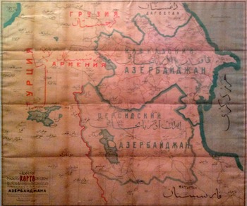
State elites and institutions often start by altering the material environment to “make” the territory part of the nation-state. State territorializing practices range from infrastructural power and projection practices to more radical changes in land/people associations. Under the Azerbaijan Soviet Socialist Republic (AzSSR) sovereignty, the main transportation links — highways and railways — went eastward and southward of NK (besides one small connecting road to Armenia, which also connected Nakhichevan, an Azerbaijani exclave southwest of Armenia) (Dash Reference Dash1989, 72) (Figure 1). These infrastructures physically connected NK to Azerbaijan, while disconnecting it from Armenia. Incorporation into state transportation networks also built in the imagination NK’s belonging to the nation-state, as well as a similar status to Nakhichevan (where Armenians no longer lived).
Map of AzSSR in 1992. Railway and roads go southward and eastward from NK. The Stepanakert-Goris (Armenia) road only became a highway after Armenians took over in 1992. [Washington, D.C.: Central Intelligence Agency, 1992; Library of Congress].

Related to infrastructural power is the construction of monuments, statues of national figures, and of everyday buildings with a “national” character (Tuan Reference Tuan1977, 176–178; Mitchell Reference Mitchell and Mitchell2002; or projection practices Ejdus (Reference Ejdus2020)). In the Azerbaijani case, due to NK’s autonomous oblast status (established in 1923) and Soviet anti-nationalist policies between the late-1930s and 1960s, Azerbaijan used this tool later and to a lesser extent, although it did build schools in the 1950s out of the “spolia” or parts and ornamental relief elements of medieval Armenian churches and cemeteries from the area (Lindsay et al. Reference Lindsay, Smith, Ghulyan and Khatchadourian2024). For example, the AzSSR Ministry of Culture built in Shusha (Shushi in Armenian, a town in NK) the Shusha Carpet Museum in 1985 (Azerbaijani National Carpet Museum 2024), the Azerbaijan State Museum of History of Karabakh in 1991, and unveiled the Monument of Natavan (a bust sculpture of an Azerbaijani poetess born in Shusha) in 1982 (Shusha City State Reserve 2024). Establishing national museums and statues in the territory embeds it as part of the national territory.
Other more radical practices that alter the material environment or population, include physically removing people and destroying built and natural environments. In the Azerbaijani case, the state used more indirect means during the Soviet era. More specifically, the ruins of Armenian towns and quarters from previous episodes of violence (such as the massacres of Khaibalikend and of Shusha in 1919–1920) were destroyed, while damaged churches and khatchkars (Armenian cross-shaped tombstones) were left in disrepair (Walker Reference Walker1991). Importantly, the narrative that Shusha is an Azerbaijani historical place (and that it was the only formerly Azeri-majority town in NK (Broers and Toal Reference Broers and Toal2013)), partly relies on the erasure of Armenian traces following the 1920 massacre, which killed and displaced the entirety of the Armenian inhabitants and destroyed the Armenian part of the city (Saparov Reference Saparov2012, 291). Other indirect practices include the discriminatory allocation of funds to NK and police harassment of Armenians (Libaridian Reference Libaridian1988), which fostered Armenian emigration, while the state actively encouraged Azerbaijanis to migrate to NK (Muth Reference Muth2014, 66).Footnote 7 According to (flawed) Soviet censuses, the Armenian proportion in NK decreased from 90 to 74 percent, while the Azerbaijani population increased six-fold from 1921 to 1987 (Yamskov Reference Yamskov1991, 645–647). Overall, physical practices helped link material environments to the core group (while erasing the link to the non-core group), laying the foundations of biased background knowledge and attachments. I now turn to the more significant ideational practices.
Ideational Practices
Beyond altering space materially to incorporate the territory into the nation-state’s, state territorializing practices also aim at altering the imagination of the territory. These practices include map-making, censuses, and inventories of resources to render the space legible to the state (and later to the people). The AzSSR government established National Institutes and Societies in Ethnography, Archaeology and History in the 1920s and 1930s to fulfill this purpose. The state commissioned inventories and maps of monuments, which systematically omitted Christian monuments in NK and the rest of AzSSR (Shnirelman Reference Shnirelman2001, 161). These revised maps and associated narratives were transmitted to the masses through touristic practices. For example, the Museum of History of Azerbaijan produced in 1956 touristic guides that omitted Armenian monuments, around 60 monasteries and 500 churches in NK, discursively erasing Armenian presence from the lands (Shnirelman Reference Shnirelman2001, 158–159).
Another prevalent state practice that structures ignorance and fosters attachments, is the re-writing of history. Historians were commissioned to write an Azerbaijani history, which was then disseminated to the public through school textbooks. How historical memory formed, how it responded to Armenian claims and Soviet pressures is a vast endeavor. I only briefly sketch how official positions on NK shifted, drawing from Shnirelman’s thorough historiographical investigation (Reference Shnirelman2001). Starting in the late 1930s,Footnote 8 historians were tasked with officializing Azerbaijanis’ indigenous status (104). The model textbook of 1939 emphasized Azerbaijanis’ autochthony by tracing their origins to Caucasian Albanians, a tribe that inhabited the region in ancient times. Interestingly, the textbook recognized that Caucasian Albanians were partly Armenianized and partly Turkified after the Seljuq invasion in the 11–12th centuries. As for NK, the textbook only mentioned its economic ties with the lowlands of the broader Karabagh province (104–106); semi-nomadic groups would take their herds to the highland pastures in the summer months, where the Armenians lived (21). This economic stance was also at the basis of the Soviet decision to transfer NK to AzSSR, which suggests it was a prevalent discourse at the time.
The mainstream Azerbaijani history school started to shift in the 1960s and became revisionist in the 1980s. In the 1960 version, Armenian influence is downplayed: the authors omitted the Armenian origin of the Albanian alphabet, Albanized important Armenian figures (111), but still mentioned intermittent Armenian rule over NK and Armenianized Albanians (110–11). In the 1980s, revisionist accounts replaced these more moderate views in the media and textbooks (123). Gradually, they argued that no Albanians were Armenianized (124), that Armenians never established an independent state in the region (142) and that no Armenian population existed in what is now NK (143). They also Albanized Armenian monuments in NK, claimed that well-known Armenian manuscripts were translations from Albanian originals and maintained that Armenians resettled in Azerbaijan only after Russia annexed Transcaucasia in 1828Footnote 9 (155, 164–173, 183). The contradictions in these accounts — for example, historian Mamedova both emphasized Albanians as a “highly integrated ethnos” (Mamedova 1986, 246; in Shnirelman Reference Shnirelman2001, 171) and traced Azerbaijani ancestry to both the distinct Albanian Church in the highlands and the Turkified Albanians in the lowlands (Shnirelman Reference Shnirelman2001, 172) — reflect early effects of structured ignorance on the historians themselves.
In addition to spreading official history through textbooks, mass media distilled historical debates, documentaries, and presidential speeches in people’s homes, while suppressing alternative accounts. Azerbaijan state media monopoly resembled other Soviet Republics’, only one television channel and radio station were available (Seyidov Reference Seyidov2020). The AzSSR also imposed the instruction of Azerbaijani history in NK schools, forbade Armenian versions, and hampered Armenian TV broadcasting or any cultural links with Armenia (Dudwick Reference Dudwick, Bremmer and Taras1993, 274–275).
In sum, this article does find the presence of state practices that structure ignorance, practices that distill a particular conception of the state territory and erase non-core others from it. Whether such practices actually resulted in a shift in manifestations of ignorance — background knowledge and cognitive mechanisms about past/ongoing oppression of the non-core group and about the symbolic significance of the disputed space — and of popular attachment, is the object of the following section. I find that they both increased by 1988.
Manifestations of Structural Ignorance and Territorial Attachment
Low Ignorance and Attachment
Two indicators hint at the low levels of structural ignorance and popular attachment at the start of Soviet rule. First, NK was not considered a “core” territory in the 1920s, especially when compared to other territories. Lack of “core-ness” is key both in terms of ignorance and attachment. On the one hand, it shows that people did not possess background knowledge about NK’s symbolic significance. On the other hand, given White’s first two indicators specifically, NK did not play a significant role for the nation and did not elicit distinct feelings. NK’s peripheral status can first be seen in 1915, when a delegation of prominent Azerbaijanis proposed an independence plan for their “homeland” to the Ottomans. The devised “Muslim state” included the provinces of Baku, Ganja, Erivan, Dagestan, and Terek, but did not mention NK (Swietochowski Reference Swietochowski and Suny1996, 221).
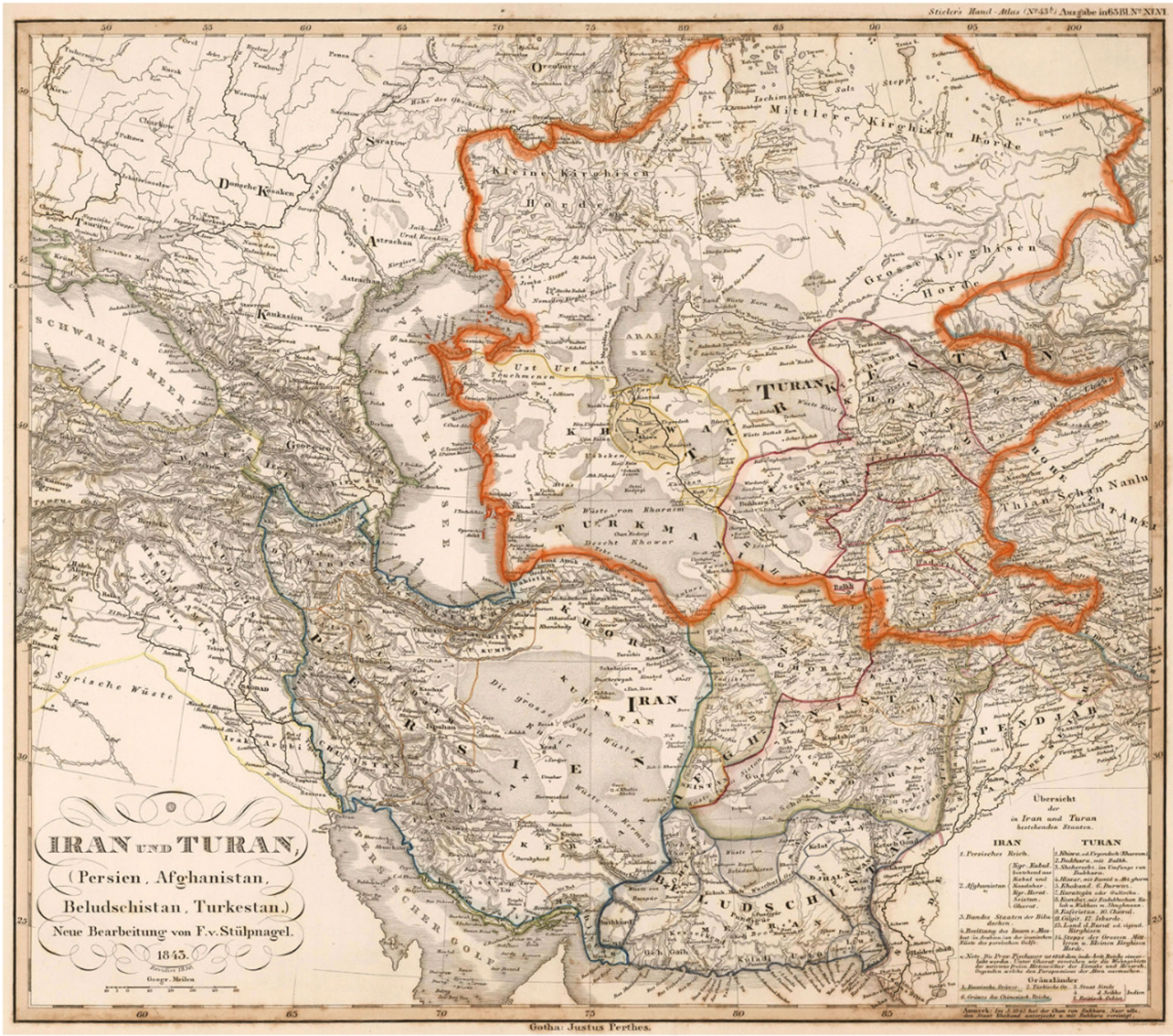
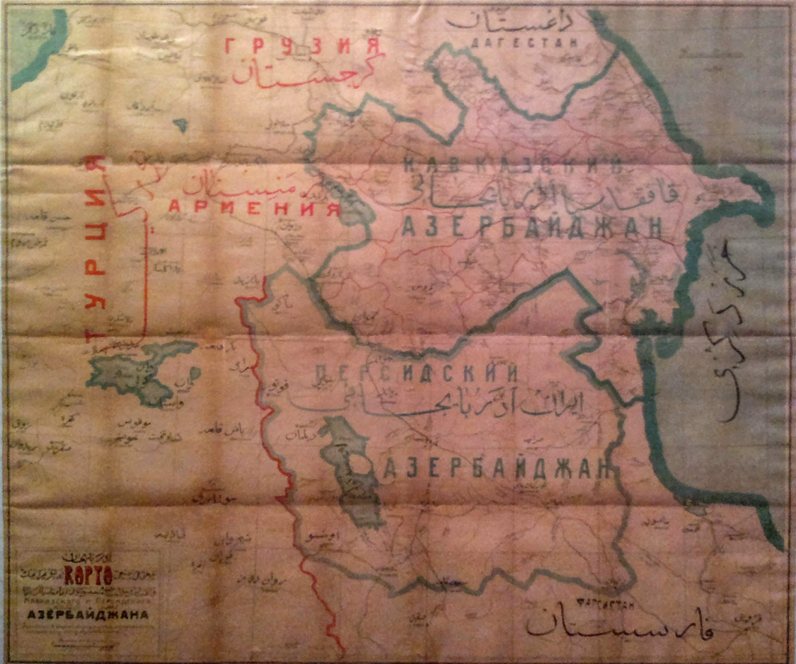
Moreover, up until the 1920s (and resuming at other times), intellectuals primarily debated whether the Azerbaijani nation should integrate the Pan-Turkic or the Pan-Islamic ideal (Swietochowski Reference Swietochowski1995, 50–65). Even when elites wavered, the population still exhibited signs of the debate. Swietochowski (Reference Swietochowski and Suny1996) documents how then proto-nationalist party Musavat, lost popular support in 1919 when the party declined to assist Kemalist fighting against Western powers in Anatolia (228). Importantly, NK was peripheral in both conceptions. Pan-Turkism emphasizes the “unification of Turkic communities” (Grigoriadisa and Opçin-Kıdal Reference Grigoriadis and Opçin-Kıdal2020, 483), whose homeland corresponds to Turan (“Land of Turks”) (Swietochowski Reference Swietochowski1995, 34). Although conceptions varied, Turan mostly spreads from Western Anatolia to Central Asia, with Central Asia mapped as Turan’s historical cradle (Swietochowski Reference Swietochowski1995, 50, 70; Grigoriadisa and Opçin-Kıdal Reference Grigoriadis and Opçin-Kıdal2020, 484) (Figure 2). The Pan-Islamic ideal focused on the unification of “Northern” and “Southern Azerbaijan,” a province in Northern Iran populated by Azerbaijanis (Swietochowski Reference Swietochowski1995, 51, 166) (Figure 3). “Southern Azerbaijan” was also the object of a vast “literature of longing,” a poetry genre about the separation of the two Azerbaijan and the beauty of the land, which peaked in the 1940s and again in the 1980s, and was widely read among Azerbaijanis (Swietochowski Reference Swietochowski1995, 166, 191; Saroyan Reference Saroyan and Suny1996, 413–414).
Map of Iran and Turan (Persia, Afghanistan, Baluchistan, Turkestan) by Adolf Stieler (Gotha: Justus Perthes, 1843), which corresponds to descriptions of Turan found in Ottoman documents. [Grigoriadisa and Opçin-Kıdal (Reference Grigoriadis and Opçin-Kıdal2020)].
Map of “Northern” and “Southern” Azerbaijan [Baku: Museum of History of Azerbaijan, 1918–1920; Wikimedia Commons]. Interestingly, the borders of the provinces (in red) in “Northern Azerbaijan” do not delimit NK yet.
Second, the relative lack of national consciousness among Azerbaijanis in the 1920s indirectly evidences a low attachment to NK. Indeed, attachment to distant lands based on the nation first necessitates an imagination of the nation. Low literacy ratesFootnote 10 and the late officialization of the name of the people “Azerbaijani” (end of the 1930s)Footnote 11 limited this imagination of fellow members and homeland, especially through the national press (Anderson Reference Anderson1991). Structural ignorance about the symbolic significance of NK and attachments was therefore low in the 1920s.Footnote 12
High Structural Ignorance and Attachment
By 1988, the situation had changed. Attachment to NK first became apparent in popular behavior: NK had become significant enough to warrant massive demonstrations and railway blockades from November 1988 to September 1989 to protest Armenian claims and the failure of the government to deal with the NK crisis (Saroyan Reference Saroyan1990, 26). The increased popularity of the Azerbaijani Popular Front, which slowly centered its program exclusively on the NK crisis (Saroyan Reference Saroyan1990, 24), and the impossibility to shift focus toward national emancipation and socio-economic development, all point to what Saroyan (Reference Saroyan1990) calls the “Karabagh syndrome” (22). The protests and the syndrome both exemplify White’s tenacity factor and a disproportionate perceptual attentiveness to NK, which is one of the cognitive mechanisms associated with structural ignorance. Moreover, background knowledge of Armenians as insatiable opportunists who had settled on Azeri lands in the 19th century prevailed in Azerbaijani responses to Armenian demands (Shnirelman Reference Shnirelman2001, 186). Lastly, the substitution of the first secretary Kämrän Baghïrov in May 1988, due to his perceived inaction regarding popular demands on NK (Saroyan Reference Saroyan1990, 18–19), confirms the bottom-up nature of the pressures (and discards alternative explanations of preference falsification). NK had become symbolically central in what unified Azerbaijanis, more so than national emancipation.
Several cognitive mechanisms that aim at preserving the dominant view of structural ignorance also appear. Following Armenian demands to attach NK to Armenia, anti-Armenian pogroms occurred in Sumgait in February 1988 and in Baku in January 1990 (where mobs respectively killed 30 and 90 Armenians, raping dozens, looting, and burning their properties, and causing about 200,000 Armenians to flee Azerbaijan (Zürcher 2007, 157–170)). Such pogroms reflect the height of anti-Armenian sentiment and an outcome of abjectification, as the abject is not entitled to equal claims to justice.Footnote 13 Following the pogroms, misremembering, misinterpreting, and “misplaced” anger — all indicators of structured ignorance—were visible. “Sumgait” came to embody something entirely different in the Azerbaijani minds. Azerbaijani journalists and TV programs (one ironically entitled the “Death Zone”) omitted Armenian massacres and focused on “the city’s endemic social, economic, and environmental problems” (Saroyan Reference Saroyan1990, 18) or how Sumgait symbolized industrial disaffection, repressing well-documented massacres. The Azerbaijani press also expressed resentment at international support to Armenians (Swietochowski Reference Swietochowski1995, 196–198), interpreting it as biased. When the USSR Supreme Court sentenced an Azerbaijani involved in the Sumgait pogroms to death, it triggered widespread demonstrations across Azerbaijan (Saroyan Reference Saroyan1990, 20), which indicates testimonial discrediting and “misplaced” anger.
In sum, state practices produced ignorance—background knowledge and cognitive mechanisms that maintain the view that NK is core to the Azerbaijani homeland and Armenians were/are not oppressed — and attachment to NK. As violence erupted in 1988, different dynamics interacted with ignorance and attachments, which I now turn to.
Phase 2: Amplifying Structural Ignorance and Attachment since 1988
The first Karabakh War (1988–1994) caused deep trauma for the Azerbaijani people. Territorial loss, massive displacements, and war crimes were accompanied by a wider sense of humiliation, resentment, and hatred (Askerov and Ibadoghlu Reference Askerov, Ibadoghlu, Yavuz and Gunter2022). In this sense, the war amplified the already existing structure of ignorance by making constructions and erasures more resonant. I first retrace the indirect effects of the war and then analyze the continued state practices after the war, which rigidified attachments even more, with a peak in the second Karabakh War of 2020.
Indirect Effects of the 1988–1994 War
First, as violence against Armenians mounted, tensions against Azerbaijanis living in Armenia also increased, which resulted in about 200,000 Azerbaijanis taking refuge in Azerbaijan. Moreover, around 600,000 Azerbaijanis, who mostly lived in the seven adjacent territories to NK, also fled when Armenians took control of the region in the war (Zürcher Reference Zürcher2007, 180). This meant that by the end of the war, almost one-eighth of the Azeri were IDPs (Askerov and Ibadoghlu Reference Askerov, Ibadoghlu, Yavuz and Gunter2022, 250). The trauma of the refugees and the trauma of Khojaly (detailed below) bolstered anti-Armenian sentiments and heightened ontological security needs (by disrupting cognitive environments), which increased the need to pursue ignorance. Moreover, traumas tainted back other memories related to NK and Armenians, and interpretations of Armenian acts. In other words, trauma amplified the misremembering and misinterpretation prescribed by ignorance and abjectification.
Second, following the anti-Armenian pogroms, around 250,000 Armenians fled Azerbaijan, and in 1995, an additional 70,000 Armenians fled NK. With the destruction of their property, this move helped strengthen the perception of a homogenous nation, the misremembering of events, and the gradual fading of the memory of coexistence (Zürcher Reference Zürcher2007, 180).
Third, the war had a “rally-around-the-flag” effect, as largely documented by the press and political scientists more generally. The Karabagh syndrome mentioned above shifted attention away from pressing socio-economic and political issues and unified a people that mostly showed apathy until then (Saroyan Reference Saroyan1990, 18). In other words, the war consolidated national awareness and with it, attachments. Importantly, after the Azerbaijani defeat in 1994, vowing to regain the territory (which corresponds to White’s third component, the tenacity factor) enabled the state and people to “go on” after a radical disjuncture (or “critical situation” in Ejdus’s terms (Reference Ejdus2020)), while preserving the self from unwanted knowledge, mostly the lack of state capacity and the artificialness of the nation.
Lastly, although the war compounded the effects of ignorance, the continuous state practices mentioned above are still significant. In 1999, around 49 percent of polled Azerbaijanis were against any compromise on the Karabakh issue, and 41 percent were in favor of limited compromises (although the survey did not specify the compromises) (RFE-RL 1999). In a sense, only half the respondents took the “no compromise” stance, indicating that the rest were not completely rigidly attached to NK yet, despite the war.
State Practices Aimed at Maintaining/Amplifying Structural Ignorance
The Azerbaijani government maintained and amplified ignorance through discourse that it spread in official speeches, in history institutes, and during commemorations. Examining presidential speeches after major negotiation rounds following the 1994 ceasefire — in 1997, 2001, and 2016 (Asbarez 1997a, 1997b, 1997c, NATO 1997, Agence France Press in Azerbaijan 2001, U.S. Department of State Archive 2001, Heydar Aliyev Heritage International Online Library 2001, Pashayeva and Asgarov Reference Pashayeva and Asgarov2001, Safarova and Gulammirzayev Reference Safarova and Gulammirzayev2001, Zeynalov Reference Zeynalov2001, Asbarez 2016, Office of the President of the Republic of Azerbaijan 2016b, 2016c, 2016d, 2016e, 2016f)— reveals a change in the discursive environment: hostile descriptions of the other increase in length and substance, while mentions of potential convergence disappear. Assertions of Armenians “occupying Azeri lands,” “annexing” territory, and perpetrating ethnic cleansing, and of the international community being biased in favor of Armenians, become widespread. The government also blames Armenians for what Azerbaijan has been blamed for — destruction of cultural heritage,Footnote 14 barbarism, and even, as I detail below, genocide. The projection on the other of negative traits and acts of the self is part of the abjectification process; preserving ontological security entails sacralizing the moral self by demonizing the other (Kinnvall Reference Kinnvall2006, 52–54). A statement President Ilham Aliyev gave to the Azerbaijani Security Council and shared with the population illustrates the diffusion of this background knowledge:
Armenia has violated all international norms. … It has barbarously destroyed all buildings, historical and religious monuments on occupied lands. … Our mosques, graves, monuments, buildings and museums lie in ruins. All valuable items have been looted. This is unprecedented barbarism. The executioners seated in the highest posts in Erivan [Yerevan] have committed the monstrous Khojaly genocide. After all, aren’t they supposed to be brought to book for that? (Office of the President of the Republic of Azerbaijan, 2016a).
Armenians are barbarians who occupy lands and are not held accountable by the international community. Interestingly, official speeches repeatedly characterize Armenians as “liars” “that cannot be trusted,” which, beyond abjectification, feeds into cognitive mechanisms of testimonial discrediting, misremembering, and misinterpreting Armenian actions.
History institutes and national commemorations also help maintain the dominant view about NK and Armenians cognitively and affectively. How institutes and commemorations spread the narrative about the “Khojaly genocide” is telling in this respect. In February 1992, Armenian forces killed at least 485 Azerbaijanis (most of them civilians) in the Khojaly village (Zürcher Reference Zürcher2007, 170). While tragic, this event appears to fit the category of war crime rather than genocide. Khojaly has, however, become an emblem for Armenian barbarism, and a way to deny atrocities perpetrated against them. The Institute of History provides a full “history” of the “Khojaly Genocide: The Tragedy of the 20th Century,” a way to mirror the widespread Armenian formulations of the 1915 Genocide as “the first genocide of the 20th century.” The section includes images of children’s corpses, which exacerbates affective reactions (Azerbaijan.az 2024). National commemorations are also conducted every year on February 26, which was declared “Day of the Khojaly Genocide” in 1994, and schools teach the event (Barseghyan and Sultanova Reference Barseghyan and Sultanova2012). Other examples of commemorations include the establishment of 8 November, the day the Azerbaijani army regained Shusha after the 2020 44-day war, and 20 September, the day the Azerbaijani military regained full control of NK in 2023, as Victory Day and State Sovereignty Day, respectively (Office of the President of the Republic of Azerbaijan 2024; 2025a). Both national holidays serve to maintain the narrative of the glorious war in the collective memory.
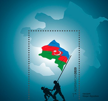
Other practices that structure ignorance on a more everyday level include the organization of conferences across Azerbaijan on “the love of Motherland and Martyrdom” by the State Committee for Work with Religious Associations (Goyusov 2021, 3). The Azerbaijani Post Office also regularly releases postage stamps, with, for example, the map of Azerbaijan in the background of a soldier holding a flag that coincides with NK (Figure 4), or the slogan “Karabakh is Azerbaijan” (Figure 5). A more controversial stamp that depicted a coronavirus health worker disinfecting NK on the map of Azerbaijani territory (Sahakyan Reference Sahakyan2023) seems to have been withdrawn from the catalogue, although stamps collating a health worker and a soldier (Figure 6) still foster the dehumanizing association.
2020 postal stamp representing soldiers with the Azerbaijani flag overlapping NK [Azerpost, 2020].

2020 postal stamp representing the Azerbaijani flag with the slogan “Karabakh is Azerbaijan!” [Azerpost, 2020].

2020 postal stamp representing a solider and a covid-19 health worker [Azerpost, 2020].

Since regaining full control of NK in September 2023, Azerbaijan has expanded its large-scale territorializing practices. Physically, the state has built roads, model villages, airports (which have been empty since their construction in 2021), a university, and museums in “liberated lands” (Azerbaijan.az 2023; Office of the President of the Republic of Azerbaijan 2024; Chapple Reference Chapple2024). Discursively, it has declared Shusha the 2024 “Cultural Capital of the Islamic World” (Ministry of Culture of Azerbaijan 2023) and has rewritten historical memory about NK (Office of the President of the Republic of Azerbaijan 2021, 2023; Trend News Agency Reference Agency2022) and the 2023 coerced exodus of the Armenians (Chapple Reference Chapple2024).
In parallel to constructions, the state also maintains ignorance through erasure. Two particular erasures are worth mentioning: the erasure of the anti-Armenian pogroms in Sumgait and Baku and the erasure of the Armenian cultural heritage in Nakhichevan, an Azerbaijani exclave formerly inhabited by pockets of Armenians, and since 2020, in NK. Both erasures preserve the dominant view that Azerbaijan did not oppress Armenians and that Armenian claims are unfounded. The Sumgait and Baku pogroms mentioned above only appear in Azerbaijan in the form of conspiracy theories. In 2018, Azerbaijani President Aliyev and the Prosecutor General’s Office officially claimed that Armenian nationalists burnt down their own houses and provoked violence to cast blame on Azerbaijanis (Kucera Reference Kucera2019). In the Baku case, January 20 — the day Soviet troops entered Baku to restore order, killing 130 Azerbaijanis — is a public holiday to mourn the victims of “Black January” (Office of the President of the Republic of Azerbaijan 2025b). This narrative conveniently omits the main reason why Soviet troops intervened — to end the seven-day anti-Armenian pogrom that had started on January 13.
The erasure of physical traces of Armenian presence on Azerbaijani territory complements the erasure of violence. Satellite research documents how Azerbaijan systematically destroyed the entirety of Armenian heritage in Nakhichevan between 1997 and 2006, more precisely, “an estimated 89 medieval churches, 5,840 cross-stones, and 22,000 tombstones” (Maghakyan Reference Maghakyan2022). An ICJ ruling in December 2021 confirmed this erasure and ordered Azerbaijan to “‘take all necessary measures to prevent and punish acts of vandalism and desecration,’ while rejecting Azerbaijan’s mirror request against Armenia” (Maghakyan Reference Maghakyan2022). Since the 2020 Karabakh War, and more so after regaining full control of NK in 2023, Azerbaijan has destroyed Armenian historic cemeteries, tombstones, churches, and some of the “spolia” schools mentioned above in NK (Lindsay et al. Reference Lindsay, Smith, Ghulyan and Khatchadourian2024).
State practices of construction and erasure aimed at maintaining ignorance, hence continued after the 1988–1994 war, and were expanded after 2020. The state amplified narratives of violence against Azerbaijanis, denied narratives of violence against Armenians, and removed physical traces that could disconfirm the dominant view. The next section assesses how these practices entrenched ignorance and attachments, the peak being manifest in the popularity of the 2020 War and youth attitudes today.
Entrenched Ignorance and Attachment
Indicators of how the population internalized a higher level of structural ignorance are difficult to encounter, especially as Azerbaijan is still an authoritarian regime with low freedom of expression. First, we can observe a shift after 2020 (starting from 2016) from the neutral term “Nagorno-Karabakh,” used in official negotiations and by the international community, to “Karabakh”/“Karabagh” (Kucera Reference Kucera2021) in official speech, media, and popular discourse. This change reflects the erasure of the distinction between the formerly mostly Armenian-inhabited territory (NK, the mountainous part of Karabakh) and the lowlands of Karabagh, inhabited by Azerbaijanis. The blurring of the distinction, which was first a tool to erase the demographic specificity of NK, is now reproduced every day and enables attachment to a broader territory, where the majority of co-ethnics were Azerbaijani.
Second, popular accounts on social media, especially in the 2020 war context, reveal the presence of background knowledge and cognitive mechanisms produced by the structure of ignorance. Student-led “Karabagh is Azerbaijan” platform, popular on Instagram and Facebook, spreads misinformation on Armenians in NK (for example, that civilians participate in combat) and the VK “Polygon Azerbaijan” account, recurrently depicts Armenians as “vermin,” with images of rats with Armenian insignia or uniforms (Dardari et al. Reference Dardari, Levsen, Setian and Peake2021). Both these examples exhibit testimony discrediting, misremembering, and misinterpreting as well as abjectification.
Such extreme manifestations also reflect Mills’s “moral non-knowing” (that is, when people can no longer discern right and wrong in seemingly obvious situations). Azerbaijani hero’s welcome of Ramil Safarov (an Azeri officer who axed to death an Armenian counterpart during a NATO training in Budapest in 2004 and who was extradited in 2012) (Walker Reference Walker2020), as well as the banalization of atrocious acts on social media (Dardari et al. Reference Dardari, Levsen, Setian and Peake2021) presage such moral non-knowing, in addition to “misplaced” pride and joy.
A third indicator of structural ignorance can be found in the dearth of conciliatory discourse in “peaceful” civil society initiatives, especially among the youthFootnote 15. In the One Young World Ambassador Community’s “Voices from Armenia and Azerbaijan” (2020), one can trace some of the cognitive mechanisms mentioned above. Focusing on the Azerbaijani side, although Armenians also display ignorance, the following statements can be found: “NK is not a disputed territory,” “Karabakh belongs to Azerbaijan,” “Azerbaijan has every right to liberate its occupied lands,” “Azerbaijan is fighting in its own territory and did not attack any country or civilians,” and “Armenians are spreading lies and misinformation.” Again, misconception, misremembering, misinterpreting, and discrediting testimony actively preserve the dominant view in the youth. Besides state repression, like the arrest of the members of the Feminist Peace Collective D18 in 2023, the public expresses disproportionate outrage against extremely rare anti-war statements. For example, statements on social media from individuals who empathize with Armenians, such as Rauf Azimov, who grew up in wartime Karabakh, were met with homophobic slurs, ridicule, and accusations of treachery (Azimov Reference Azimov2023). Similarly, the 17-individual formation Azerbaijani Leftist Youth faced online harassment and threats in 2020 following their anti-war statements (Pfeilschifter and Barberis Reference Pfeilschifter and Barberis2023).
As for attachment to NK, White’s second indicator of feelings expressed towards the territory (Reference White2000), can be observed in Azerbaijani folklore. For instance, collections of poems, (Azertag 2014), literature (Sayfutdinova Reference Sayfutdinova2011), and songs such as — the graphic and popular — Ozan Arif’s “Garabakh or death, there is no other way” display affective descriptions of NK. Interestingly, dissenting voices, such as the novel Stone Dreams (2012), where Azeri writer Aylisli narrates anti-Armenian massacres in his home village in Nakhichevan and in Sumgait and Baku, triggered mass outrage in Azerbaijan, with demonstrations and “public burning of the writer’s book” (Mamedov Reference Mamedov2016). These reactions not only reflect “misplaced” anger — a sign of ignorance — but also the need to preserve the self from unwanted knowledge at all costs.
Another indicator of attachment, White’s tenacity factor, appears in how popular the 2020 war was. Beside high presidential support, massive protests with the slogan “Karabakh is Azerbaijan!” gathered 30,000 people in Baku in July 2020 (two months before the war) to demand that the government retake KarabakhFootnote 16 (BBC 2020). Independent and oppositional Shi’i clerics as well as the Caucasus Muslim Board repeatedly called believers to “pray for the liberation of [their] lands from occupation” (Goyushov Reference Goyushov2021). The willingness to suffer for the now blurred territory of Karabakh was hence widespread at this point.
A related indicator of both ignorance and attachment is the inability to compromise, which has shifted since 1999. According to the last Caucasian barometer of 2013, 44 percent of the respondents would “never accept” NK having a high autonomy within Azerbaijan (which used to be the default Azerbaijani position after the war, International Crisis Group 2005). More importantly, 81 percent would “never accept” NK being an independent country, 90 percent would “never accept” the creation of a special administrative region governed conjointly by Azerbaijan and Armenia, and 96 percent would “never accept” NK to be part of Armenia. These results show not only the popular uncompromising positions about NK but also an exacerbated stance when Armenians enter the picture. This exacerbation reflects the abjectification process and the background knowledge that Armenian claims are unfounded.
A more extreme trend can be seen in the youth, most of whom were not born during the first Karabakh War. In a recent survey conducted in 2022 among the younger generation (aged 18–35), 76 percent of the respondents said they would not support granting any status to NK Armenians within Azerbaijan, while 59 percent did not think coexistence of Azerbaijanis and Armenians in NK is possible (Agora Analytical Collective 2023). In another survey conducted in 2022, among respondents aged 16–29, more than 60 percent stated they would not permit a person from Armenia to enter the country (Pfeilschifter and Barberis Reference Pfeilschifter and Barberis2023). Lastly, in yet another survey, more than half of the young respondents believed that “cooperating with Armenia” can threaten the country’s national values (52 percent), national security (53 percent), and statehood (51 percent) (Friedrich-Ebert-Stiftung 2023). The younger generations’ more extreme views point to the long-term effectiveness of the construction of ignorance, and particularly to youth policies such as the Youth Development Strategy for 2015–2025, which sought to deepen feelings of patriotism, mainly through education (Pfeilschifter and Barberis Reference Pfeilschifter and Barberis2023).
Overall, the period following the war witnessed the parallel entrenchment of structural ignorance and its intertwined products — the dehumanization of Armenians and territorial attachment to NK. Since the remainder of the Armenian population has fled NK (about 100000 people) (International Crisis Group 2023), structural ignorance is likely to remain at a high level. As unmaking ignorance requires the presence of alternative narratives to counter the dominant view, even if the “Aliyev dynasty” were to decline, there would be no bearer of such narratives left. The structure of ignorance erases inconsistencies and sustains the official narrative of Azerbaijan as a multicultural and civic nation (Broers and Mahmudlu Reference Broers and Mahmudlu2023, 58).
Conclusion
Homelands can change, and people can form durable attachments to territories that are not (initially) sacred or inhabited by a majority of co-ethnics. These attachments are the byproduct of a structure of ignorance, which maintains the dominant view that the territory is of symbolic significance to the nation and that denies the oppression/erasure of the non-core group inhabiting it. Throughout Azerbaijani nation-building, the significance of NK increased, abjectification of Armenians deepened, and attachments rigidified. On the one hand, state territorializing practices rewrote histories, drew maps, built roads, changed landscapes, moved or killed people, and infrastructure, textbooks, museums, tourist guides, and speeches distilled these new imaginations of the land. On the other hand, testimonies and memories were discarded and replaced with new narratives, particular interpretations were fostered, particular emotions exacerbated, particular attachments prescribed, all of which sustained the overall structure. When Armenians contested sovereignty over NK, they challenged the state constructions and erasure, which underlaid people’s cognitive environment and sense of self. People then actively pursue ignorance and become more rigidly attached to its product in order to preserve the self from unwanted knowledge — the erasure of the other, and the artificialness of the self.
The in-depth examination of the structuring of Azerbaijani attachment to NK reveals an important lesson for our understanding of nation-building, territorial attachments, and ontological security. Although the case studied lies on the extreme end of the spectrum, all nation-building processes entail some degree of structural ignorance: to a large extent, nations seek to hide their artificialness and erase their internal other. In the process, they also produce attachments to state territories, which may have significant ramifications. Further studying these attachments should prove fruitful in postcolonial settings, where the integration of peripheral territories inherited from former colonial oppressors may be more difficult and dealt with through ignorance. Importantly, such structured ignorance often involves the denial of the oppression of the non-core group, which produces highly relational territorial attachments (that is, hatred of Armenians is intertwined with attachment to NK). The combination of entrenched ignorance and attachments may render some territorial conflicts even more intractable, as resolution would necessitate knowledges that cannot be known. More generally, attachment to state territories could interact with other issues, such as climate change and populism. Material changes in the landscapes or the accrued presence of an “other” in the state territory would disrupt people’s territorial attachments and likely trigger ontological security crises. Overall, investigating different levels of structural ignorance and attachments may reveal much more about ourselves and our nations than we might want to know.
Acknowledgments
I would like to thank Jennifer Mitzen, Amanda Robinson, Alex Wendt, Cameron Macaskill, two anonymous reviewers, and the editors for their insightful comments. I am also grateful to the participants of the OSU 2024 Writing for Publication Workshop, the panel on History, Memory, and the Desire for Recognition at the 2024 ISA, and the 2023 Serious Games Seminar in Serbia for their helpful feedback.
Disclosure
None.


 Open access