


Introduction
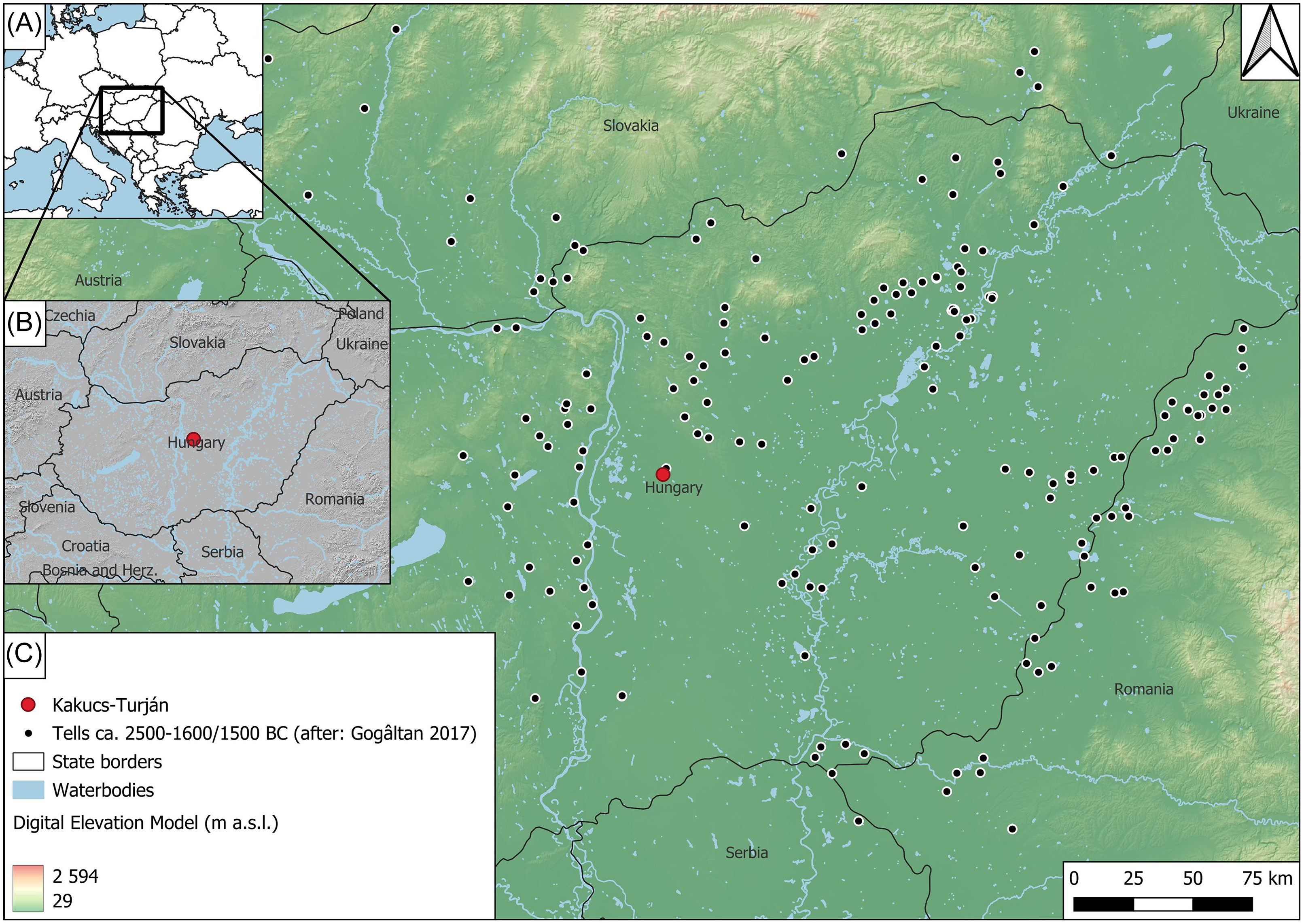
During the Middle Bronze Age (ca. 2000–1500 BC), the Carpathian Basin witnessed new cultural groups characterized by distinctively different pottery styles and burial rites but unified by the occupation of sites surrounded by ditches or combinations of ditches and ramparts (Bóna Reference Bóna1975; Kovács 1984; Sørensen and Rebay-Salisbury Reference Sørensen and Rebay-Salisbury2008). Due to their long occupation, many such sites are classified as multi-layered settlements (Gogâltan et al. Reference Gogâltan, Cordoş and Ignat2014; Jaeger Reference Jaeger2016). Despite extensive research, there remains a lack of detailed information on the absolute chronology, spatial development, and chronological relationships between settlement occupation and fortification construction (Jaeger Reference Jaeger2016; Staniuk Reference Staniuk2021). Most site chronologies are based on funerary ceramic typologies associated with broad temporal ranges and high uncertainties (Jaeger Reference Jaeger2016; Staniuk Reference Staniuk2021). Kakucs-Turján is only one of nearly 190 multilayered Middle Bronze Age (MBA) settlements in the Carpathian Basin with a tripartite division of space (Harding Reference Harding2018; Jaeger Reference Jaeger2016) (Figure 1). This, combined with its high-resolution archaeological record makes it ideal for investigating the diachronic relationship between MBA habitations and fortifications (Filatova Reference Filatova2020; Staniuk Reference Staniuk2020).
Location of Kakucs-Turján: A—location of the site in Europe (basemap: naturalearthdata); B—location within the distribution area of the Vatya culture in Central Europe (basemap: Shuttle Radar Topography Mission—SRTM—7.5” 15” 30” (250 m, 500 m, 1 km), naturalearthdata, Copernicus EU-Hydro dataset); C—location within the tell settlement network ca. 2500–1600/1500 BC (basemap: Shuttle Radar Topography Mission—SRTM—7.5” 15” 30” (250 m, 500 m, 1 km), natural earthdata, Copernicus EU-Hydro dataset, sites after: Gogâltan Reference Gogâltan2017).

The site is encircled by external ditches and is further separated into three zones through a system of internal ditches. Archaeological research conducted between 2013 and 2017 by a Polish-Hungarian-German team has investigated household economy, interregional trade, and the absolute chronology of buildings within a stratified, tell-like area (Jaeger et al. Reference Jaeger, Kulcsár, Taylor and Staniuk2018a; Niebieszczański et al. Reference Niebieszczański, Jaeger, Pető, Hildebrandt-Radke, Kulcsár, Staniuk, Taylor and Czebreszuk2019; Pető et al. Reference Pető, Niebieszczański, Serlegi, Jaeger and Kulcsár2019). It is hypothesized that the site’s internal divisions served distinct functions, such as residential, economic, and livestock areas (Jaeger Reference Jaeger2016). The researchers favored a static model, suggesting that the ditches and partitions were contemporaneous and purposefully designed, based on limited data regarding the absolute chronology of ditch stratigraphy (Niebieszczański et al. Reference Niebieszczański, Pető, Serlegi, Hildebrandt-Radke, Galas, Sipos, Páll, Onaca, Spychalski, Jaeger, Jaeger, Kulcsár, Taylor and Staniuk2018, Reference Niebieszczański, Jaeger, Pető, Hildebrandt-Radke, Kulcsár, Staniuk, Taylor and Czebreszuk2019; Pető et al. Reference Pető, Niebieszczański, Serlegi, Jaeger and Kulcsár2019). It is essential to establish a reliable chronology for these European Bronze Age fortifications because they represent significant labor investments by power centers that may have collapsed around 1600 BC due to environmental and cultural stresses, including warfare (Duffy et al. Reference Duffy, Parditka, Giblin and Paja2019; Earle and Kristiansen Reference Earle and Kristiansen2010; Fischl et al. Reference Fischl, Kiss, Kulcsár, Szeverényi, Meller, Bertemes, Bork and Risch2013; O’Shea et al. Reference O’Shea, Parditka, Nicodemus, Kristiansen, Sjögren, Paja, Pálfi and Milašinović2019). While fortifications play a central role in these interpretations, their complex stratigraphy and chronology are mostly unknown, and linking habitation and fortification chronologies directly is more of an assumption than an established fact. This impacts demographic models of the Bronze Age “collapse”, which often assume the simultaneous abandonment of settlements and fortifications (Duffy et al. Reference Duffy, Parditka, Giblin and Paja2019; Kienlin Reference Kienlin2020; Meller et al. Reference Meller, Bertemes, Bork and Risch2013; O’Shea et al. Reference O’Shea, Parditka, Nicodemus, Kristiansen, Sjögren, Paja, Pálfi and Milašinović2019; Staniuk Reference Staniuk2021).
Kakucs-Turján’s static model was tested using geoarchaeological methods to determine whether it is supported by empirical data. It further serves as a methodological framework for the investigation of large and complex fortifications, which is challenging using the conventional, excavation-based archaeological workflow. The key questions of the study were the following:
Ditch chronology: Were all ditches constructed simultaneously? Were they built during the main occupation phase and then abandoned concurrently with the settlement?
Regional context of fortifying settlement space: Could the construction of fortifications have been part of a broader, chronologically discernible phenomenon in the Carpathian Basin region?
We have extracted cores from four different sections of the ditch system to collect samples for radiocarbon dating and chronological modelling, conduct sedimentological, geochemical, and microcharcoal analysis, to answer these questions.
Materials
Kakucs-Turján archeology and research history
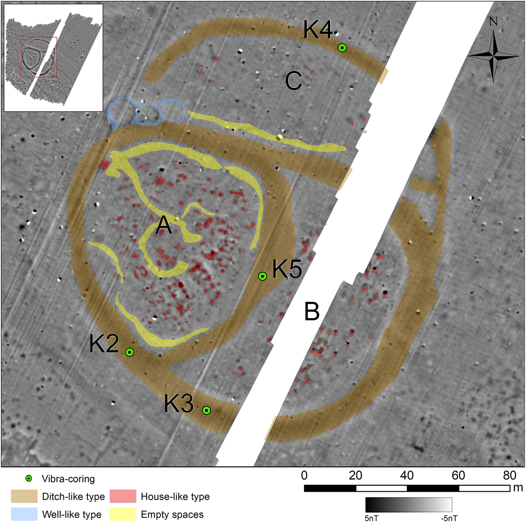
Based on aerial photography, the site was initially considered a bipartite settlement divided into zones A and B, but following geophysical prospection, a third northern zone C was identified (Niebieszczański et al. Reference Niebieszczański, Pető, Serlegi, Hildebrandt-Radke, Galas, Sipos, Páll, Onaca, Spychalski, Jaeger, Jaeger, Kulcsár, Taylor and Staniuk2018) (Figure 2). Other interpreted features were well-like structures in the northwestern part of the external ditch, empty spaces devoid of geophysical anomalies, and house remains (Niebieszczański et al. Reference Niebieszczański, Pető, Serlegi, Hildebrandt-Radke, Galas, Sipos, Páll, Onaca, Spychalski, Jaeger, Jaeger, Kulcsár, Taylor and Staniuk2018, Reference Niebieszczański, Jaeger, Pető, Hildebrandt-Radke, Kulcsár, Staniuk, Taylor and Czebreszuk2019). Following the existing cultural development models for the Carpathian Basin and the initial coring program, these zones were initially considered contemporaneous with MBA and representative of functional differences between occupational (A), occupational/economic (B), and economic (C) zones (Pető et al. Reference Pető, Serlegi, Niebieszczański, Molnár, Jaeger, Kulcsár, Taylor, Jaeger, Kulcsár, Taylor and Staniuk2018, Reference Pető, Niebieszczański, Serlegi, Jaeger and Kulcsár2019).
Magnetic plan of Kakucs-Turján settlement (after: Niebieszczański et al. Reference Niebieszczański, Jaeger, Pető, Hildebrandt-Radke, Kulcsár, Staniuk, Taylor and Czebreszuk2019) with the position of 2021 coring and indicated settlement’s parts (A, B and C).

Since the surveyed area had limited landscape visibility, it was initially considered to be a flat settlement with a single occupation layer. A highly visible anomaly in zone A, interpreted as remnants of a house, was targeted for excavations to test this hypothesis. This provided insight into the domestic economy of the inhabitants, validated the cultural affiliation of the site (Vatya culture), and yielded samples for radiocarbon dating to determine the site’s absolute chronology (Kulcsár et al. Reference Kulcsár, Jaeger, Kiss, Gábor, Müller, Pető, Serlegi, Szeverényi and Taylor2014; Jaeger et al. Reference Jaeger, Kulcsár, Taylor and Staniuk2018a, Reference Jaeger, Staniuk, Müller, Kulcsár, Taylor, Jaeger, Kulcsár, Taylor and Staniuk2018b).
The excavations also provided evidence of a multilayered occupation typical of tell settlements, confirming the presence of at least four houses associated with both flat and tell-like occupation (Jaeger et al. Reference Jaeger, Staniuk, Müller, Kulcsár, Taylor, Jaeger, Kulcsár, Taylor and Staniuk2018b; Staniuk Reference Staniuk2020). Human activity associated with long-term occupation is evidenced by remains of agricultural subsistence (plant macroremains and animal bones; Biller Reference Biller, Jaeger, Kulcsár, Taylor and Staniuk2018; Filatova Reference Filatova2020) as well as by tool and pottery production (Gál Reference Gál, Jaeger, Kulcsár, Taylor and Staniuk2018; Staniuk Reference Staniuk, Jaeger, Kulcsár, Taylor and Staniuk2018a, Reference Staniuk2020), indicating both continuity of occupation and interactions with other regions in the Carpathian Basin (Jaeger Reference Jaeger, Jaeger, Kulcsár, Taylor and Staniuk2018, Reference Jaeger, Dębiec, Górski, Müller, Nowak, Pelisiak, Saile and Włodarczak2022; Staniuk Reference Staniuk, Rezi and Németh2018b, Reference Staniuk, Kreiter, Kulcsár and Jaeger2022).
Based on the excavation results the following site development model was proposed: the area was initially settled in the beginning of the Early Bronze Age (EBA 1; ca. 2400 BC) and following a hiatus, intensely resettled in the end of the Early Bronze Age (EBA 3; ca. 2100 BC). The “flat” occupation persisted until the Middle Bronze Age (ca. 1950 BC) when the site was first levelled using refuse, effectively creating a “tell-like” settlement. This occupation form persisted at least until the late Middle Bronze Age (ca. 1640 BC). During this time at least one ditch construction event took place (ca. 1844–1745 BC), which was potentially filled in a few years later (1760–1686 BC). During this period, at least three houses were sequentially constructed on top of each other (Jaeger et al. Reference Jaeger, Staniuk, Müller, Kulcsár, Taylor, Jaeger, Kulcsár, Taylor and Staniuk2018b; Staniuk Reference Staniuk2020).
Based on geomagnetic prospection, the dimensions of the ditches surrounding zones A and B had an approximate average width of 10m and were characterized by discontinuities between individual segments (Niebieszczański et al. Reference Niebieszczański, Jaeger, Pető, Hildebrandt-Radke, Kulcsár, Staniuk, Taylor and Czebreszuk2019; Pető et al. Reference Pető, Niebieszczański, Serlegi, Jaeger and Kulcsár2019) (Figure 2). Coring with a hand-operated gouge auger showed that these ditches measured approximately 4 m in depth and were filled with biogenic deposits with traces of laminations, potentially indicative of an aquatic environment (Pető et al. Reference Pető, Niebieszczański, Serlegi, Jaeger and Kulcsár2019). The previous research (Reference Pető, Niebieszczański, Serlegi, Jaeger and Kulcsár2019) lacked drillings within the ditch surrounding zone C.
Methods
Core retrieval
Four cores were extracted in different sections of the ditch system (K2-K5; Figure 2). The method used was vibra-coring (Canti and Meddens Reference Canti and Meddens1998) operating on an AtlasCopco Cobra TT jackhammer (1600 r/m). A 1-m-long sampler 0.063 m in diameter with a plastic tube of 0.05 m in diameter was used to collect the sediments. After extraction, the cores were split in half, and the main lithological units and occurrence of datable material were described. As the sediments represented predominantly sandy silts units, their compaction was close to 5%. In all cases, the compact sediments of the first meter necessitated the use of a hand-operated drill.
Core K2 was positioned within the magnetic anomaly of the external ditch in the southeastern part of zone A (Figure 2) and was drilled to 5.00 m below ground level (b.g.l.). K3 was located southeast of K2 in the southernmost section of the outer ditch, but in the part surrounding zone B (Figure 2). Its maximum depth was 4.50 m b.g.l. Core K4 was taken from the northernmost margin of the site within the ditch zone C (Figure 2). The depth reached only 2.5 m b.g.l. The last core, K5, was taken from the ditch between zones A and B (Figure 2) down to the depth of 3.95 m b.g.l.
Sedimentological and geochemical analysis
Granulometric analysis of the core sections was conducted using the laser diffraction method with a Malvern Mastersizer 2000, equipped with a wet dispersion unit (measuring grain diameters up to 2000 μm). Samples were taken approximately every 0.05 m or more frequently when required by the lithological variability of the sediments. Gradistat software was used to calculate basic grain size parameters based on the formulae by Folk and Ward (Reference Folk and Ward1957). To represent the grain size distribution, sediment classification according to the USDA standard was applied.
A loss on ignition (LOI) analysis was also performed, where a 1 g dry sample was combusted in a muffle furnace at 550°C for 6 hr (Dean Reference Dean1974; Heiri et al. Reference Heiri, Lotter and Lemcke2001). The CaCO3 content was determined using the Scheibler method (Myślińska Reference Myślińska2016).
Radiocarbon dating
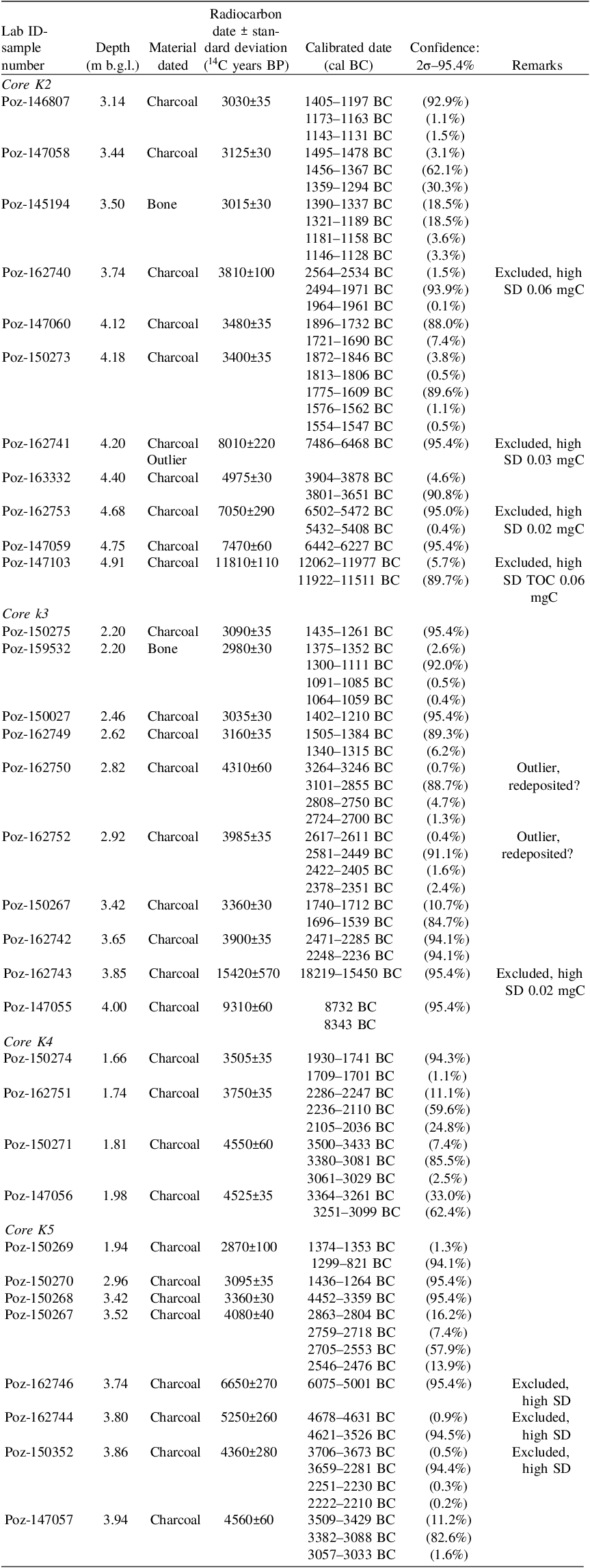
A total of 31 charcoal and two bone fragments were selected for radiocarbon (14C) dating. All charcoal fragments were very small (> 2mm) as larger fragments were not present (or preserved). AMS dating was conducted in the Poznań Radiocarbon Laboratory and the results were calibrated using OxCal v. 4.4.4 software (Bronk Ramsey Reference Bronk Ramsey2009) with the IntCal20 atmospheric curve (Reimer et al. Reference Reimer, Austin, Bard, Bayliss, Blackwell, Bronk Ramsey, Butzin, Cheng, Edwards and Friedrich2020). The 14C AMS dating results are presented in Table 1. All dates are expressed in the 95.4% probability range throughout the paper.
Results of radiocarbon dating. Samples excluded due to low precision or stratigraphic inversion are noted in the “Remarks” column

To correlate parallel sections of the profiles, the following dates were each amalgamated into one calibrated age range using the Combine function in OxCal: (i) two samples from the burnt organic layer in the K2 core (Poz-150273 and Poz-147060), and (ii) samples from the charcoal layer in the K2 profile (Poz-150273) and the layer in which the ditch was established in the K5 profile (Poz-150270), as these are stratigraphically contemporaneous.
Poz-150273 and Poz-147060 from the K2 profile and Poz-150270 from the K5 profile as the combination of the charcoal layer in the K2 profile with the establishment of ditch reflected in the K5 profile, and (iii) Poz-150273, Poz-147060, Poz-150267, Poz-150274, Poz-150274, of the lowest sections of ditches reflected in the K2, K3 and K4 and K5 profile.
Nine samples (Poz-162740, Poz-162741, Poz-162753, Poz-147103, Poz-162743, Poz-150267, Poz-162746, Poz-162744 and Poz-150352) were excluded from the stratigraphical analysis due their high standard deviation of 100-570 years, likely caused by their low carbon content (<0.2 mg). An additional two samples from core K3 (Poz-162750 and Poz-162752) were considered as outliers (they were older than the sequence and both were inverted stratigraphically).
Macrocharcoal analysis
The sediments from one ditch section (K2) were subjected to macrocharcoal analysis as it was the only one to contain macroscopic traces of fire. For this study, 2 cm3 samples were processed through bleaching to enhance the contrast between charcoal and other organic matter (Whitlock and Larsen Reference Whitlock, Larsen, Smol, Birks, Last, Bradley and Alverson2001). The samples were subsequently sieved using a 500 μm mesh, and the charcoal fragments were categorized into two size groups (above and below 600 μm) to detect a local fire signal (Adolf et al. Reference Adolf, Wunderle, Colombaroli, Weber, Gobet, Heiri, van Leeuwen, Bigler, Connor, Gałka, La Mantia, Makhortykh, Svitavská-Svobodová, Vannière and Tinner2018). The examination was carried out under a binocular microscope at 60 × magnification.
Results and interpretation
Cores stratigraphy, lithology and chronology
The stratigraphy of each core represents a rather homogenous pattern of four main units: the preoccupation natural layer (NL), a transition level between the ditch backfill and natural layer (NL/DT), ditch primary backfill during occupation (DT) and colluvial layers deposited after the settlement was abandoned (BF). These units correspond to the main soil levels recorded in previous coring campaigns (Pető et al. Reference Pető, Niebieszczański, Serlegi, Jaeger and Kulcsár2019) and were simplified to better understand the chronostratigraphy of anthropogenic events.
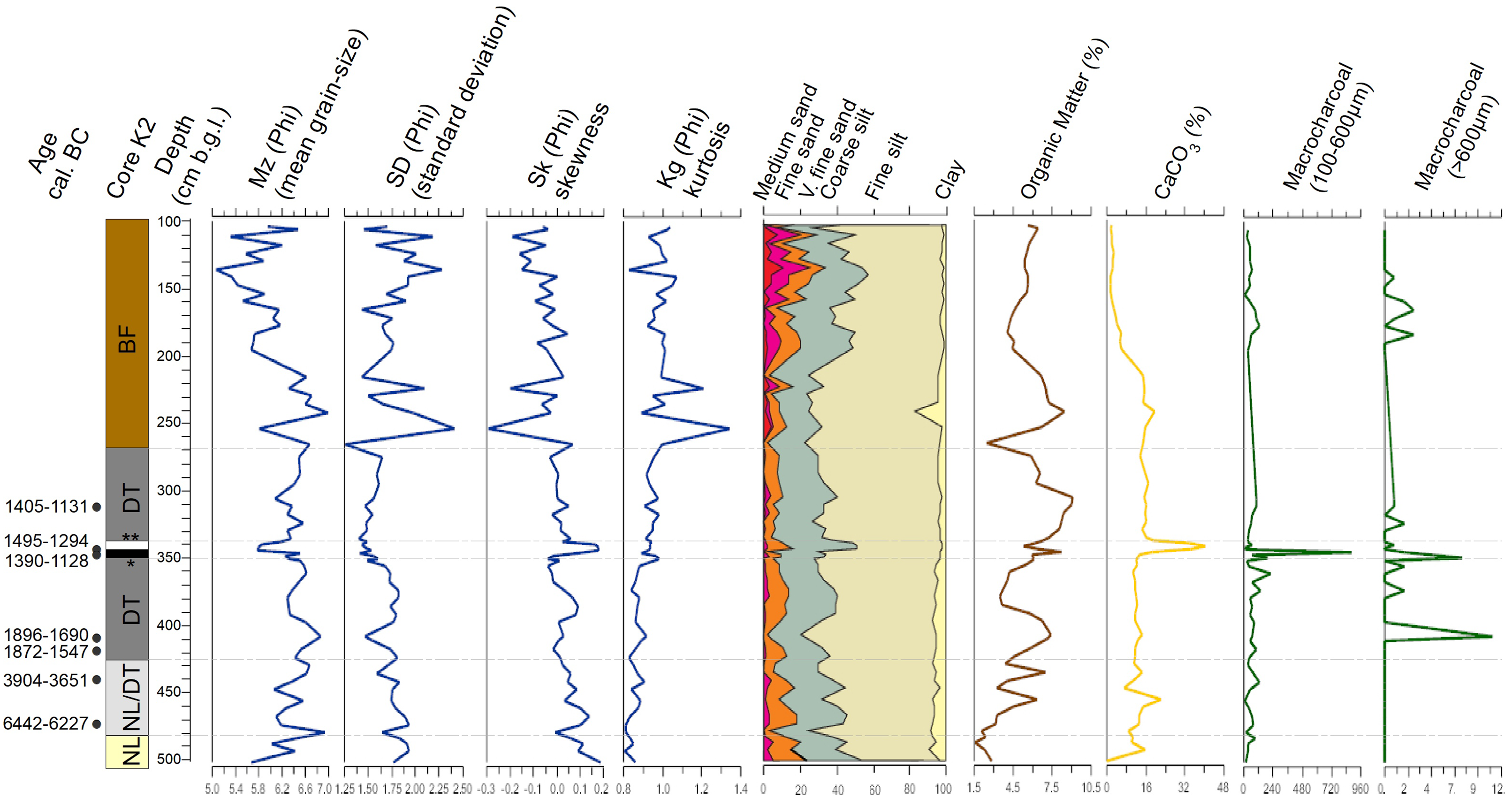
Core K2—outer ditch in zone A
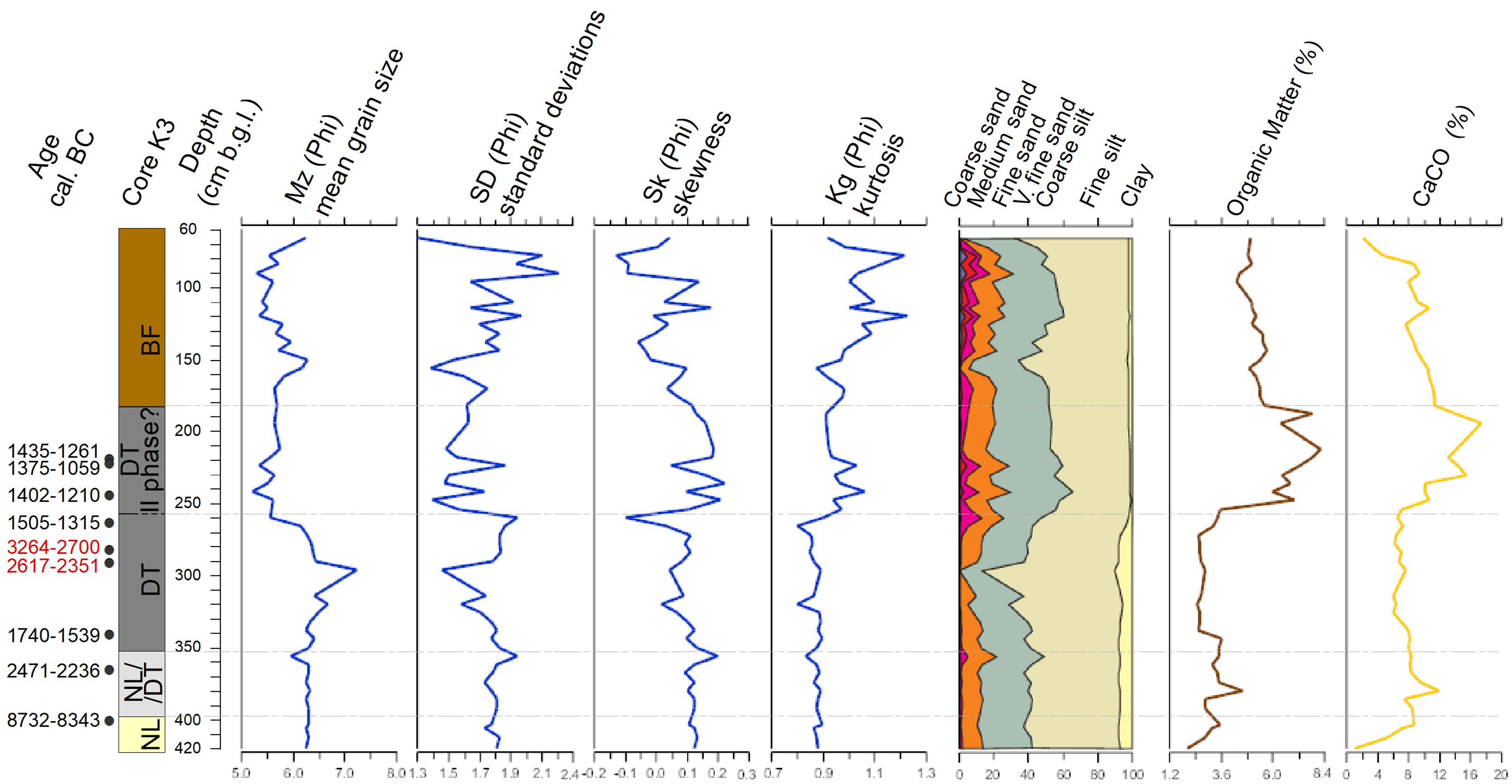
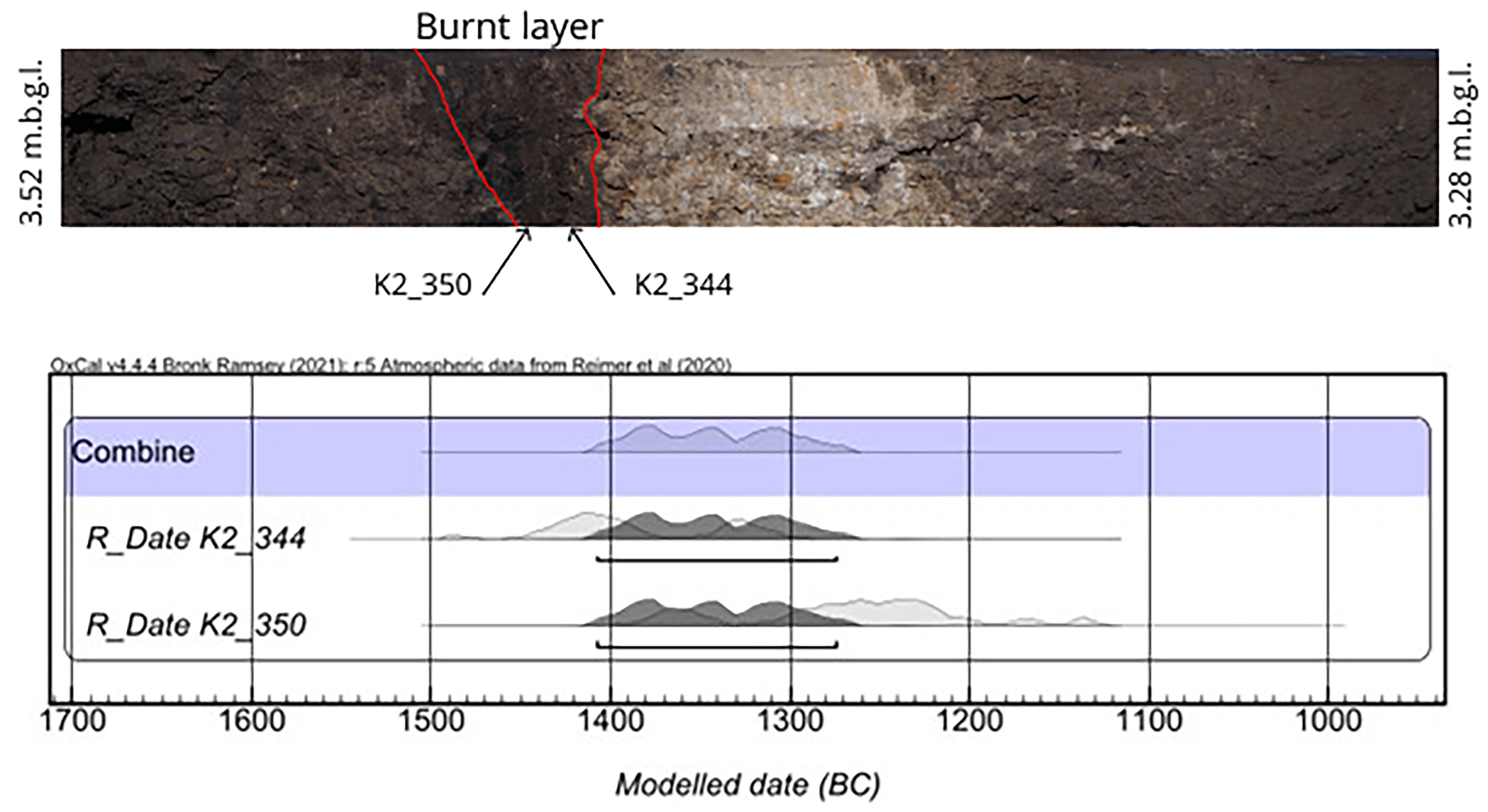
From the bottom of the core at 5.60 m b.g.l. to 4.80 m b.g.l. (Figure 3) fine and well-sorted dark yellow sandy silts were encountered (NL) (Mz: 5.8-6.2 phi). They were characterized by horizontal layering of iron oxides (red laminae) and very organic content (μ = 1.5%). The date retrieved from this section (4.94 m b.g.l.) revealed an age of 12,062–11,511 cal BC (Table 1). Above, gray fine silts with a scarce amount of charcoal were documented (NL/DT). This layer was registered up to 4.25 m b.g.l. This unit represents the period before the settlement, respectively: 6442–6227 cal BC and 3904–3651 cal BC (Table 1). The next unit was identified as the main backfill of the ditch and spanned from 4.25 to 2.70 m b.g.l. (DT). The layer was lithologically poorly sorted but was stable throughout the layer (SD: 1.5–1.75phi), with a high organic content (μ=7.5phi). It contained several charcoal pieces (both smaller and larger than 600 μm) and weathered fragments of pottery, marking its anthropogenic origin. The lowermost level directly above the NL/DT layer provided two dates from depths of 4.18 and 4.12 m b.g.l. (1872–1547 cal BC and 1896–1690 cal BC, respectively) while one date from 4.2 m b.g.l. (7486–6468 cal BC) was excluded due to high standard deviation (Table1). Within the backfill, a level of burnt organic matter was identified between 3.45 to 3.40 m b.g.l. It was also characterized by a distinct concentration of macrocharcoal (480 particles/cm3), including fragments measuring more than 600 μm. This layer is interpreted as a burnt humic horizon which eroded into the ditch. This is supported by a slight change in the fractional division of sediment samples within the burnt layer, which is characterized by the peak value of coarser material (i.e. sand and coarse silt) indicating an increased deposition from the adjacent areas. The same is visible in increased skewness, suggesting that the deposition of allochtonic material took place. Analysis of two charcoal samples (3.50 and 3.44 m b.g.l.) dated the layer was dated to 1390–1128 cal BC and 1495–1294 cal BC, respectively. Above the burnt horizon, a 0.05-m-thick layer of white sediments (daub debris) was registered with a notable increase of CaCO3 (peak of 44%). It might indicate the wash-out of destroyed building material (i.e., daub) from the inner part of the settlement, the burnt layer might have alternatively functioned as a level on which carbonate recrystallized from stagnating water. The absence of these two layers in other cores can be explained by elevation differences. The K2 core was obtained from the lowest ditch section in the area where the outwash of material from the settlement would be directionally deposited. The possible firing event was estimated to have occurred between 1408–1274 cal BC (95.4%) according to the Combine function in OxCal, however with a poor Acomb (Accumulated Combination) agreement of 40.2%. The topmost part of the DT layer (3.14 m b.g.l.) was dated to 1405–1131 cal BC. One radiocarbon date from the middle of DT was excluded due to a high standard deviation (SD) of ±100 years. The main backfill unit was overlain by the last stratigraphic unit (2.78 up to 1.0 m b.g.l.), which comprised dark brown sandy silts. It lacked anthropogenic remains and was characterized by unstable sedimentary conditions indicated by high SD (>2.25 phi) and varying Mz parameters (5–7 phi). The topmost part consisted of A-horizon continued to the ground surface.
Stratigraphy, lithology, macrocharchoal occurrence and dating of core K2.

Core K3—outer ditch in zone B
The natural deposits represented by dark yellow sandy silt (NL) (Mz: μ=6.2 phi) occurred at the bottom of the core at 4.20–3.98m b.g.l. (Figure 4 ). Charcoal recorded in NL at 4.00 m b.g.l. provided a date between 8732–8343 cal BC. Next, a gray unit of sandy silts (Mz: μ = 6.2 phi) occurred and continued to a depth of 3.55 m b.g.l. (NL/DT) and was dated by a charcoal sample from 3.65 m b.g.l. to 2471–2236 cal BC. Another date from a sample from 3.85 m b.g.l. was excluded due to a high SD of ±570 years. The main backfill unit (DT) was identified between 3.55 and 2.55 m b.g.l. and consisted of dark gray sandy silts (Mz: 6–7.2 phi). This fill was characterized by relatively stable sedimentary conditions given the similar proportions of OM and CaCO3 (respectively: μ = 2.4% and 7.5%), as well as skewness (μ = 0.05 phi) and kurtosis (μ = 0.85 phi). Charcoal fragments and weathered pottery sherds were observed in the layer. The DT section was dated to between 1740–1539 cal BC (charcoal at 3.42 m b.g.l.) to 1505–1315 cal BC (charcoal at 2.62 m b.g.l.) (Table 1). Above this level, dark brown sandy silt (BF) characterized by varying sedimentological parameters and scarce anthropogenic indicators (charcoal and artifacts) was encountered. Three samples dated the lowermost part of the section to 1402–1210 (charcoal at 2.46 m b.g.l.), 1375–1059 (animal bone at 2.2 m b.g.l.), and 1435–1261 (charcoal at 2.2 m b.g.l) cal BC (Table 1). This unit continued to 0.60 m b.g.l., after which A horizon was registered to the top surface.
Stratigraphy, lithology and dating of core K3.

Core K4—outer ditch in zone C
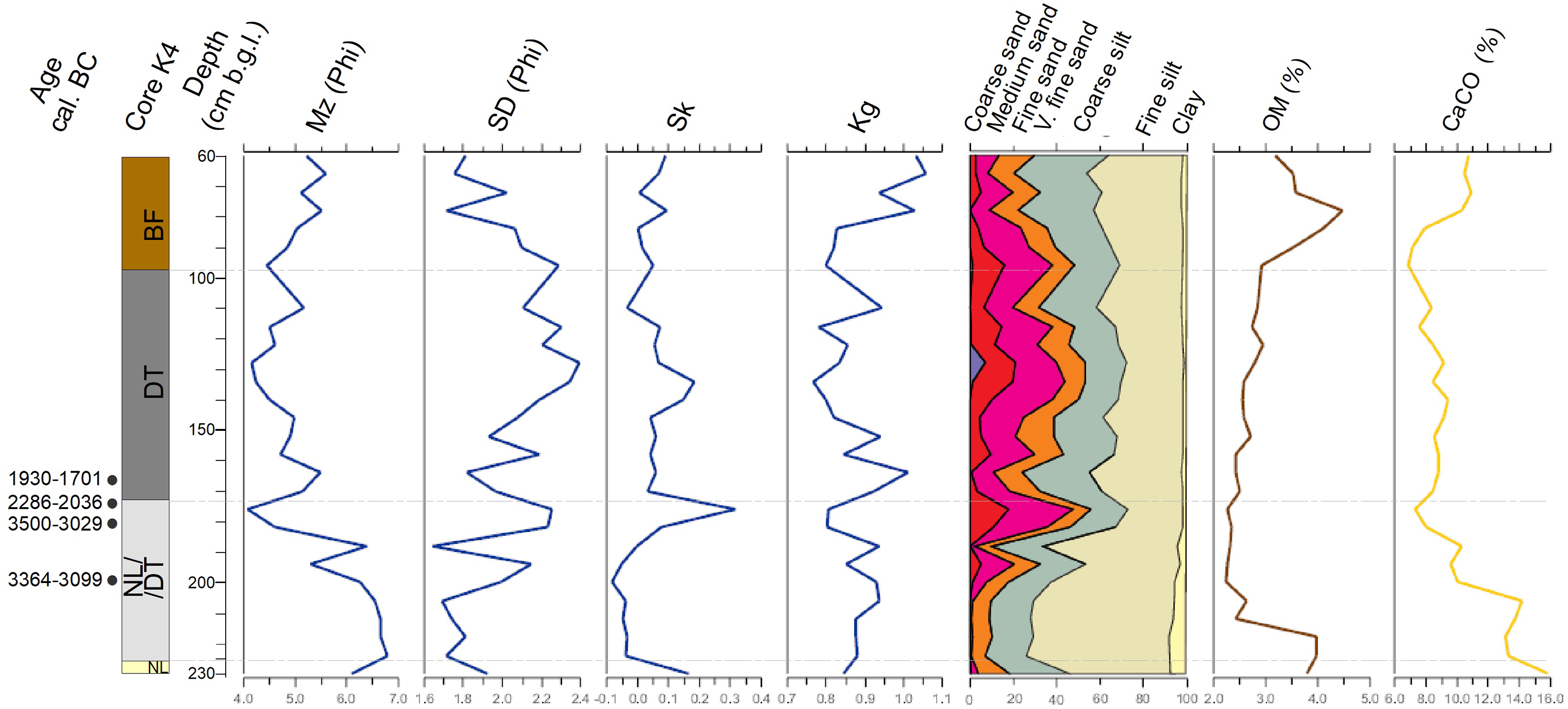
The bottom of the core revealed a natural layer (NL) of dark yellow silts at 2.30–2.25 m b.g.l. (Figure 5). The next unit (NL-DT), encountered between 2.55–1.72 m b.g.l. consisted of dark brown silt with a few charcoal fragments, three of which indicated a continuous chronological sequence: 3364–3099 (charcoal at 1.98 m b.g.l.), 3500–3029 (charcoal at 1.81 m b.g.l.), and 2286–2036 cal. (charcoal at 1.74 m b.g.l.) cal BC (Table 1). Above this layer, from 1.72–0.95 m b.g.l., was the primary backfill of the ditch (DT), consisting of sandy silt of stable sedimentary parameters along the profile (i.e., Mz: 4.2–5 phi; Sk: 0.0–0.15 phi). The high proportion of sand (up to 57%) distinguishes this layer from that in other cores, which may signify a slightly different lithological background. Also, a stable share of OM (μ = 2.8%) and CaCO3 (μ = 9%) was attributed to this unit. The only charcoal recorded within the DT occurred at the bottom (at 1.68 m b.g.l.) and dated between 1930–1701 cal BC. The topmost layer within the core was the gray sandy silts of the backfill (BF) which continued to 0.6 m b.g.l.
Stratigraphy, lithology and dating of core K4. Abbreviations: Mz—mean grain size; SD—standard deviation (sorting); Sk—skewness; Kg—kurtosis; OM—organic matter.

Core K5—inner ditch between zones A and B
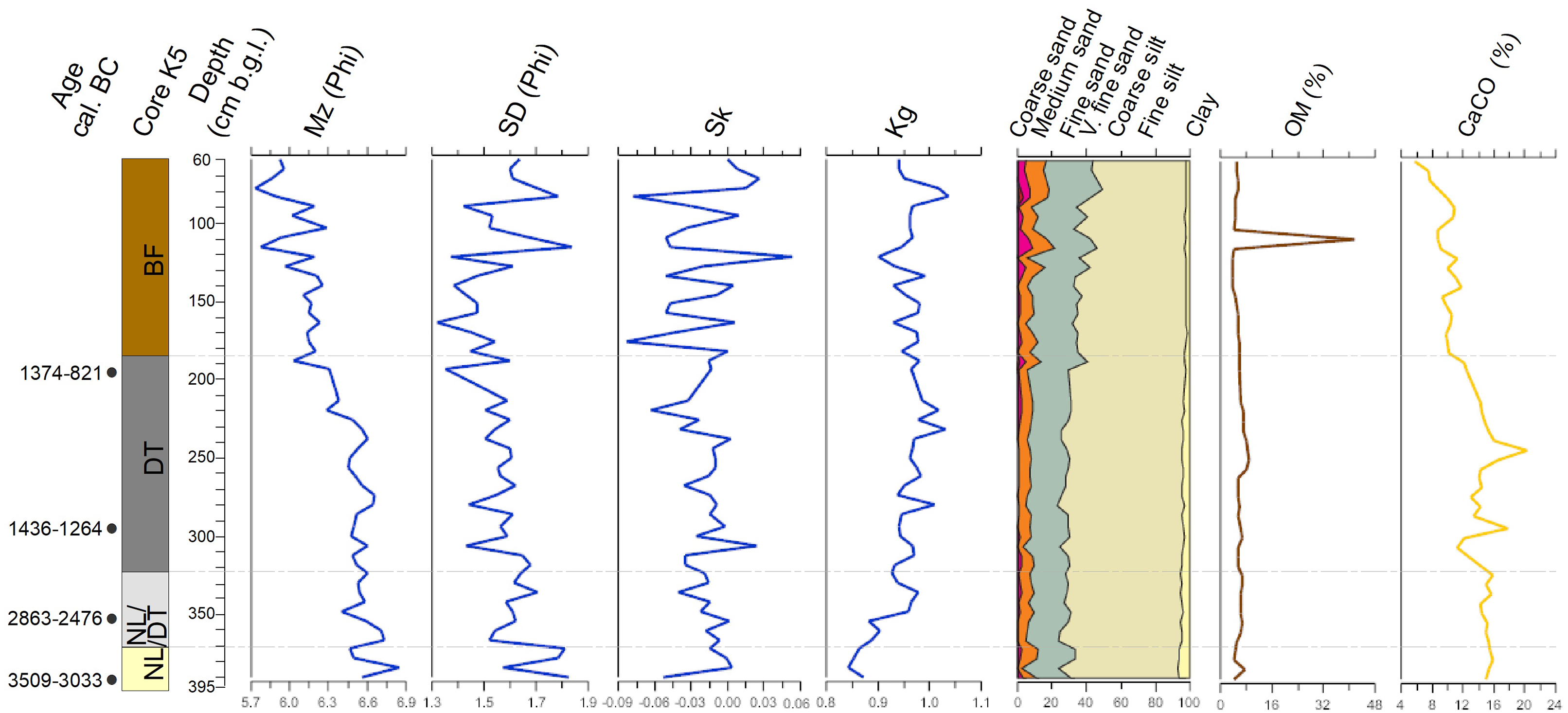
The very bottom of the core consisted of dark yellow sandy silt (NL) (Figure 6) that continued to the depth of 3.7 m b.g.l. Three charcoal pieces (at 3.86, 3.8 and 3.74 m b.g.l.) provided dates with a high standard deviation (±260 – 270 years) but given other obtained results, provide a noncontradictory dating of the pre-ditch phase stage to 3706–2210, 4678–3526 and 6075 –5001 cal BC, respectively. Another charcoal from 3.94 m b.g.l. provided a date of 3509–3033 cal BC. From 3.70 m b.g.l., light gray sandy silt (NL/DT) occurred and continued to 3.22 m b.g.l. The unit was dated using a single charcoal fragment (from 3.52 m b.g.l.) to 2863–2476 cal BC. The main ditch backfill (DT) was identified between 3.22 and 1.85 m b.g.l. It was characterized by fragments of weathered pottery fragments and daub and consisted of dark gray sandy silts (Mz: 5–6.6 phi). A relatively stable share of sedimentological parameters was observed throughout the layer (SD: μ = 1.6 phi); however, the carbonate fraction was the most variable of the DT units within all cores. The lower (2.96 m b.g.l) and uppermost (1.94 m b.g.l.) levels of the ditch’s main backfill were respectively dated to 1436–1246 and 1374–821 cal BC. Above, backfill reaching to 0.60 m b.g.l. was found, which was itself covered by the A horizon that continued to the top surface.
Stratigraphy, lithology and dating of core K5.

Discussion
Chronology and function of the Kakucs-Turján ditches
Sedimentological parameters suggest that the ditches backfill (DT) occurred under relatively stable depositional conditions, unlike the colluvial layers (BF). The latter were characterized by a higher variability of SD, Sk and Kg parameters, as well as the basic geochemistry (OM and CaCO3), which can be caused by a pulsatory sedimentary environment. Therefore, we may treat the chronological sequence at the bottom and the top of the DT unit as respectively the creation of the ditch and the abandonment of the settlement, or, alternatively, the start of the colluvial processes.
Based on the chronostratigraphy of cores K2, K3, and K4, we suggest that the ditch construction occurred between 1930 and 1539 cal BC (Figure 7). This is consistent with the excavation-based estimated date of the redeposition of soil over zone A, but suggests that the source of the soil was not, the internal ditch as previously proposed, but rather the external one (Staniuk Reference Staniuk2020: 379). Outstanding in these terms is the earliest date for the ditch section between zones A and B from core K5 (Figure 7). Based on the radiocarbon date retrieved from 2.96 m b.g.l., the construction of the ditch must have occurred around 1436–1264 cal BC. However, this should be treated with caution, as the lowest level of DT was registered at 3.22 m b.g.l., ca. 30 cm lower than the obtained date.
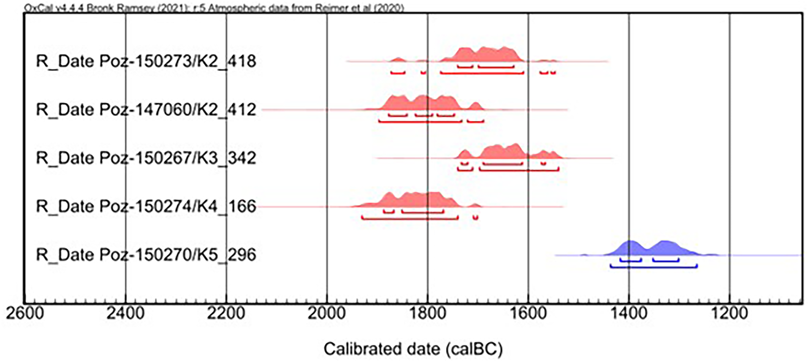
Radiocarbon dates (95.4%) of the lowest sections of DTs’ in each of the coring (in red: K2, K3 and K4, in blue: K5).

If we consider the date from core K5 as reliable, the results indicate that the construction of a ditch between zones A and B happened approximately 350 years later (ca. 1436–1264 cal BC). It is notable that this is roughly contemporaneous with the firing event registered in K2 at the outer ditch section of Zone A around 1408–1274 cal BC (Figure 8).
Combination of dates Poz-150273 and Poz-147060 from the burnt organic layer in K2 core. Raw data report from Oxcal: Combine() χ2-test: df=1 T=5.136 (5% 3.841) 68.3% probability 1394–1366 BC (24.5%) 1359–1335 BC (20.5%) 1323–1296 BC (23.3%); 95.4% probability 1408–1274 BC (95.4%); poor agreement n=2 Acomb= 40.2% (An= 50.0%).

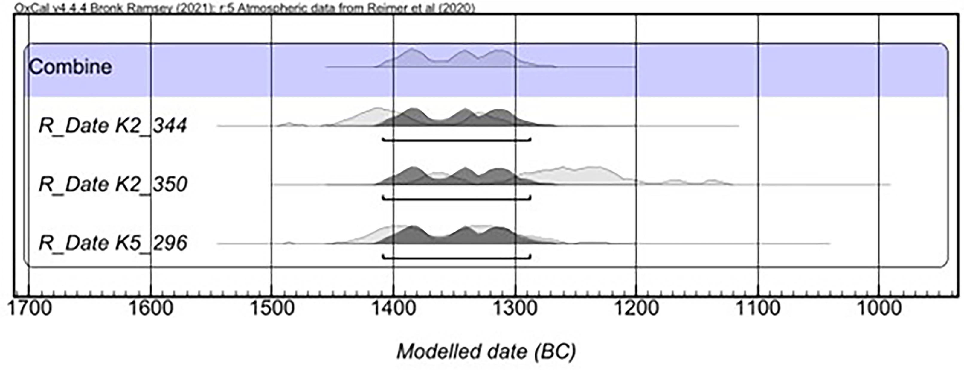
The construction of the ditch between zones A and B requires special attention in relation to the fire event. According to the result of combined dates from the K2 core (Figure 8) and the beginning of the ditch formation in K5, it seems that the ditch must have been built after the deposition of the burnt material seen in core K2. We thus combined the dates of the firing event and the lowest sample in of the K5 core DT layer, which indicated that the beginning of the latter might be contemporaneous with the burnt layer in K2 (the combined date for these three determinations is 1409–1288 cal BC with 95.4% with an Acomb index of 48.2%) (Figure 9). As such, we interpret that the ditch was constructed to separate zones A and B directly after the possible fire event in zone A.
Combination of dates Poz-150273/K2-418, Poz-147060/K2_412 and Poz-150270/K5_296. Raw data report from OxCal: Combine() χ2-test: df=2 T=5.505 (5% 5.991) 68.3% probability 1396–1374 BC (24.2%) 1351–1332 BC (18.7%) 1326–1302 BC (25.4%);95.4% probability 1408–1288 BC (95.4%); Agreement n=3 Acomb= 48.2% (An= 40.8%).

Given that we have established the chronology of the ditch’s construction, we shall now consider their abandonment (Figure 10). Dating of the colluvial backfill (BF) is only possible using the results from core K3, where both the uppermost section of DT and the lowest sections of BF were sampled. The transition–or archaeologically understood abandonment–of this feature must have happened between two date ranges: 1505–1315 cal BC (95.4%; Poz-162749) and 1375–1059 cal BC (95.4%; Poz-150027). The youngest date for ditch use from core K2 was 1405–1131 cal BC (Poz-146807). However, this date did not originate from the uppermost level of the K2’s DT unit. Another date for the end of the ditch’s function is characterized by a high uncertainty, as it extends to 1374–821 cal BC (core K5, Poz-150269, 95.4%). There is also no evidence for the end of ditch sedimentation from core K4. Given the available results, we are confident that the ditches were abandoned in the second half of the 2nd millennium BC, which also extends the existing chronology of the site (Jaeger et al. Reference Jaeger, Staniuk, Müller, Kulcsár, Taylor, Jaeger, Kulcsár, Taylor and Staniuk2018b; Staniuk Reference Staniuk2020).
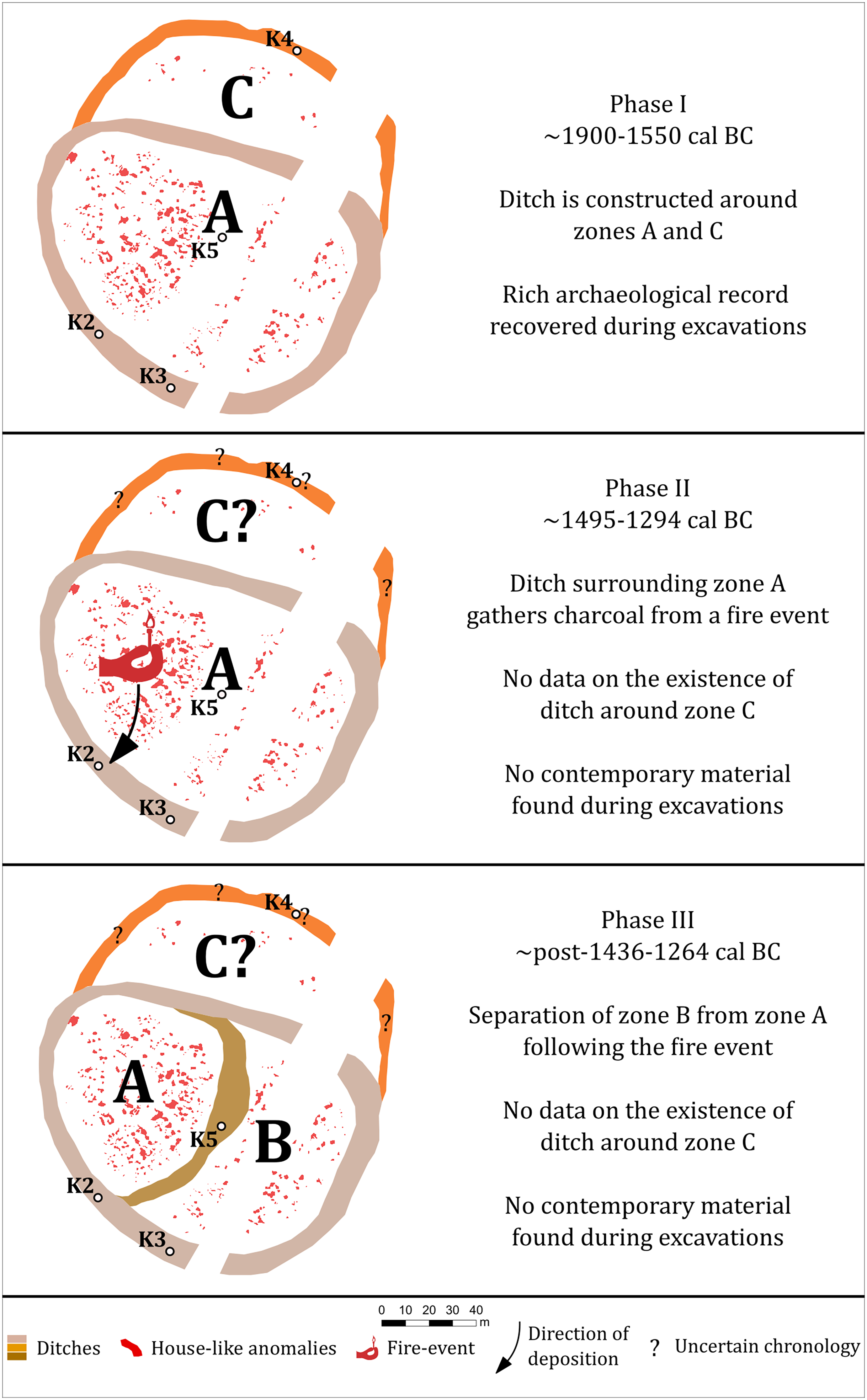
Site history model based on the dating of the ditches: 1—start of the occupation with the construction of a large ditch encircling the entire area of the settlement (1900–1550 cal BC), 2—a large fire event causes an accumulation of burnt material in the southern part of the ditch (1495–1294 cal BC), 3–the settlement is divided into zones A, B, C following the large burning event (1436–1264 cal BC).

Fortifying settlement space—a regional perspective
The results provide further evidence about the complex role of fortifications, which could have played a defensive, functional, and/or symbolic purpose (Delfino et al. Reference Delfino, Coimbra, Cardoso and Cruz2020; Jaeger Reference Jaeger2016). For the Middle Bronze Age Carpathian Basin, these attributes are generally applied across all sites, irrespective of their individual histories (Reményi Reference Reményi, Jaeger, Czebreszuk and Fischl2012; Szeverényi and Kiss Reference Szeverényi, Kiss, Fernández-Götz and Roymans2018). However, recent findings from other sites in the region indicate that while warfare could have been an important factor, the chronological offset between individual sites, divergent development pathways, as well as post-depositional destruction suggest more complex explanations for their emergence and decline.
In Fidvár by Vráble (Slovakia), ditch construction took place in three stages, two of which were preceded by their infilling and the re-use of newly created habitable space (Bátora et al. Reference Bátora, Behrens, Gresky, Ivanova, Rassmann, Tóth, Winkelmann, Kneisel, Kirleis, Dal Corso, Taylor and Tiedtke2012; Skorna et al. Reference Skorna, Kalmbach and Bátora2018). Of the three construction horizons 2400/2300–2050 (IIA), 2050–1950/1900 (IIB), and 1730–1630 (III), only the final was preceded by a decline following a large fire event (Falkenstein et al. Reference Falkenstein, Bátora and Rassmann2008; Skorna et al. Reference Skorna, Kalmbach and Bátora2018). However, unlike Kakucs-Turján, the development of Fidvár by Vráble indicates a radial expansion of the inhabited area rather than exclusive occupation of the enclosed space (Skorna et al. Reference Skorna, Kalmbach and Bátora2018). The site itself has nonetheless undergone significant destruction and erosion since its initial discovery as approximately 1m thick layer of archaeological deposits are no longer accounted for (Bátora et al. Reference Bátora, Behrens, Gresky, Ivanova, Rassmann, Tóth, Winkelmann, Kneisel, Kirleis, Dal Corso, Taylor and Tiedtke2012).
At Emőd-Nagyhalom (Hungary), initial settlement occurred before ca. 2000 BC, possibly contemporaneously with the construction of the ditch (Kienlin Reference Kienlin2020). Synchronization of the habitation and ditch duration is less precise, as the habitation layer yielded a somewhat unlikely final date of ca. 1888–1697 cal BC, while the final date from the ditch was ca. 1865–1627 cal BC (Kienlin Reference Kienlin2020). Whether this indicates a simultaneous abandonment of the entire area is controversial, as the site has undergone significant destruction in recent years, losing approximately 50–100 cm of archaeological sediment since its discovery (Kienlin Reference Kienlin2020).
The earliest evidence of human activity at Tard-Tatárdomb (Hungary) corresponds to late third millennium BC, followed by the construction of a single ditch ca. 2000 BC (Kienlin Reference Kienlin2020). The structure itself was continuously in use until ca. 1600 BC with two discernible depositional phases in the same structure (Kienlin Reference Kienlin2020). However, unlike Emőd-Nagyhalom, the archaeological record of the habitation area is more ambiguous and only tentatively suggests a chronological gap throughout the entire occupation history of the settlement and the preserved layers (Kienlin Reference Kienlin2020). Finally, some evidence of site destruction through a combination of erosion and ploughing has been recognized, although its impact remains undetermined (Kienlin Reference Kienlin2020).
Other contemporary sites such as Nižná Myšľa, Včelince, or Polgár-Kenderföld Kiscsőszhalom are rather problematic when it comes to synchronizing habitation sequences with the duration of fortifications (Jaeger Reference Jaeger2016; Kienlin Reference Kienlin2020). Hypotheses surrounding the backfilling of ditches and construction of houses above infilled structures has been suggested based on archaeological fieldwork, but precise synchronization of these processes require verification through radiocarbon dating (Jaeger Reference Jaeger2016; Kienlin Reference Kienlin2020).
Together, the evidence suggests the presence of a “fortification horizon” across the Carpathian Basin ca. 2000 BC, which underwent a regional trajectory of change possibly linked to the growth and decline of settlements in the region. The divergent site histories indicate that, while in some cases fortifications were maintained alongside settlements, other communities were able to restructure them according to ongoing needs.
Rather than advocating for a specific role, our findings indicate that a process-oriented, historical approach to examining prehistoric fortifications is essential for broader discussions on the overall functionality of settlement components (Ribeiro Reference Ribeiro2018). Prehistoric fortifications were not static installations, unchanging in their function, form, and meaning. Instead, they were structures subject to modifications driven by both internal and external factors. It can be assumed that their evolving functions influenced both how they were perceived and their potential symbolic significance.
Together with findings from northeastern Hungary and southwestern Slovakia, the new findings from Kakucs-Turján further corroborate the theory that estimates of settlement duration are likely skewed due to arbitrary chronological thresholds resulting from sampling biases and taphonomic factors (Staniuk Reference Staniuk2021). Most multilayered settlements are located in agriculturally intensive areas where recent plowing has likely destroyed the final occupational layers (Staniuk Reference Staniuk2020). Unlike surfaces, deeper ditch fills are protected from such destructive processes. Sampling only the uppermost preserved layers of such sites causes a probability distribution spike in the radiocarbon dating results around the final preserved layer. Without additional sampling of other potentially contemporary or later areas, or accounting for this problem within a refined analytical framework, this spike may be erroneously interpreted as evidence of a rapid population decline.
However, the chronology of the ditch separating Zones A and C at Kakucs-Turján during later stages remains unresolved due to limited data, specifically the lack of a Bronze Age cultural layer documented during previous corings and excavations (Pető et al. Reference Pető, Niebieszczański, Serlegi, Jaeger and Kulcsár2019). The original study design was aimed at answering the research questions by targeting the anomalies least likely to have been disturbed by later re-cutting of the ditches. As coring provides an 8 cm diameter insight into the sampled stratigraphic sequence, identifying high-resolution changes in mixed sediment was considered highly uncertain.
Conclusion
The geochronological investigations of Kakucs-Turján provided data for the following model of site development. (i) At the beginning of the settlement’s rise in the first half of the 2nd millennium cal BC, the ditch system was created around Zones A and C (as the only ones existing at that time). (ii) Around the mid-2nd millennium cal BC, a fire event occurred in Zone A, which deposited organic matter in the outer ditch in the south and was followed by washout of daub debris. (iii) Shortly thereafter, the ditch was created and divided the primary Zone A into Zones A and B. The available data do not provide information about the ditch surrounding Zone C in stages (ii) and (iii). These findings indicate a complex fortification history at the site, as they suggest that large-scale collaborative works occurred after the site was established, and that further modifications occurred after a possible fire caused the occupied area to decrease. Finally, the findings indicate a chronological offset regarding the end of the site’s habitation as the absolute chronology of the ditch lasts approx. 300 years longer than determined by the absolute chronology of the preserved, occupied structures. The study also emphasizes the importance of multitiered fieldwork approaches that integrate geophysical prospection, core sampling, and targeted excavations to more accurately reconstruct settlement histories. Together with recent evidence from other sites in the region, the study further challenges the theory that places 1600 BC as the arbitrary threshold for the collapse of Bronze Age societies.
Acknowledgments
This text was prepared as part of a project funded by the National Science Centre (project no. 2020/37/B/HS3/02561) and in cooperation with the MTA–BTK Lendület “Momentum” Bases Research Group (2023–2028) project.

 Open access