Introduction
The significance of rock art rests, to a great extent, upon its relationship with the landscape. This discourse can be passively or actively constructed and is the result of long use, or deliberate ideological strategies, or both (e.g. Reference CriadoCriado 1991; Reference BradleyBradley 1997; Reference ChippindaleChippindale & Nash 2004). The exploration of these spatial relationships has become a familiar feature of recent years. However, the focus on the interaction between the site and its immediate surroundings needs to be complemented by attention to aspects such as neighbouring natural features, the distribution of images and the orientation and vista of the panels that carry them (Reference TilleyTilley 1991; Reference BradleyBradley 1997; Reference SwartzSwartz & Hurlbutt 1994).
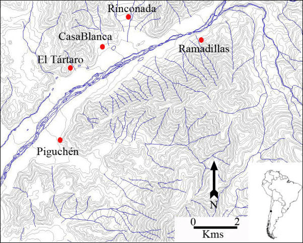
This paper is a preliminary interpretation of systematic fieldwork in the Putaendo River region of central Chile (Figure 1). This region, noted for its rich and diverse archaeological heritage, is also characterised by a high concentration of pecked rock art.
Map of the study area.

The study area
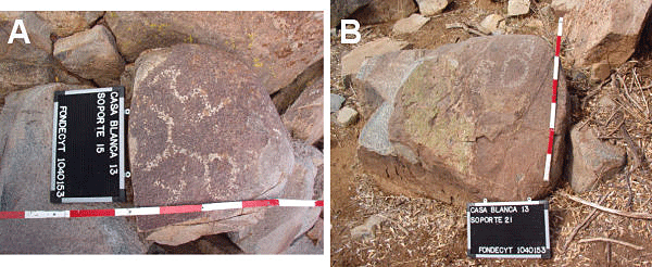
Recent studies have suggested that two rock art styles exist within the area. The first, Style I, is associated with the Late Intermediate period, dating to AD 1000-1430 (Reference TroncosoTroncoso 2005a). This distinctive style is thought to have been executed by self-sufficient peasant communities. A second style, Style II, is assigned to the Late period, dating to AD 1430-1530, and belongs to local communities who were within the sphere of power of the Inca state. Both styles are expressed in petroglyphs and are uniquely characterised by an abundance of geometric and curvilinear forms (circles, squares and lines) with occasional anthropomorphic and zoomorphic representations (Figure 2).
Examples of rock art. 2a: Style I. 2b: Style II.

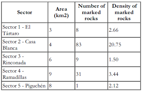
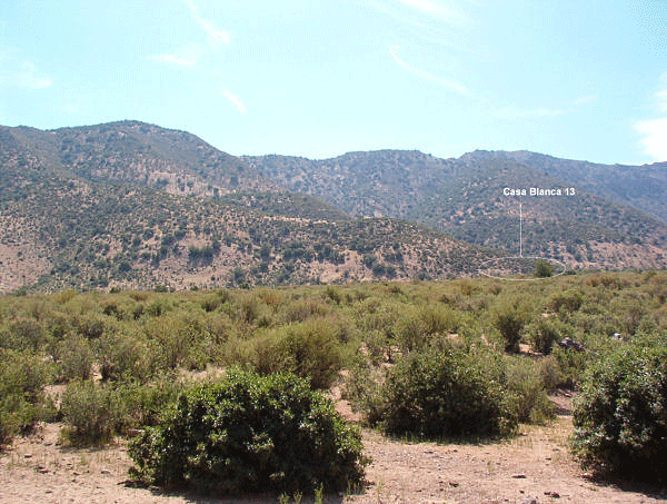
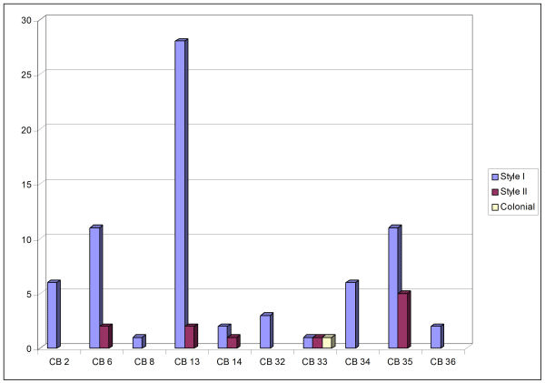
Differences in the spatial distribution of rock art in the Putaendo Valley have previously been noted, particularly the high concentration of engravings within the Casa Blanca sector (Reference TroncosoTroncoso 2005b) (Table 1). The characteristics of the Casa Blanca cluster, such as its setting in the hills (Figure 3), the large quantity of marked rocks (Figure 4) and the presence of a cairn cemetery (Ancuvina El Tartaro site), suggest an organised sacred space. The site belongs to the Late Intermediate period, but was reoccupied during the Late or Inca and Early Historic periods (Reference TroncosoTroncoso 2005b).
Identified rock art sites in the study area (divided by sectors)

View of the Casa Blanca sector and of Casa Blanca 13.

Quantification of engraved rocks in the study area.

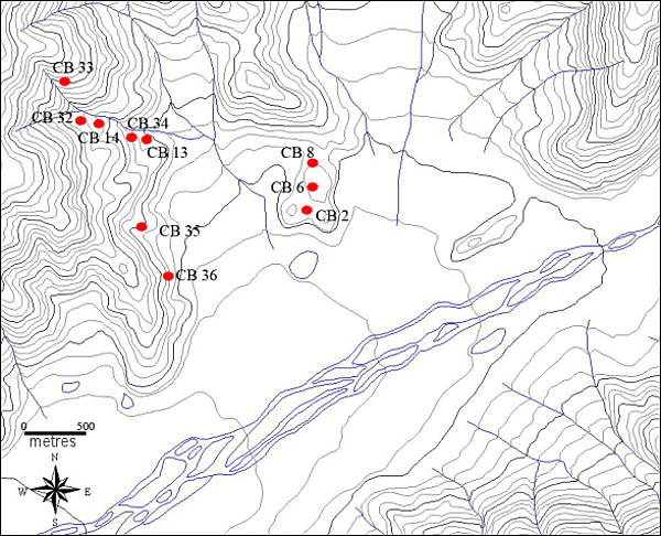
Eighty three engraved panels have been identified within the study area, distributed among the re-entrants of the south-eastern foothills (Figure 5). Here I focus on a group of 27 carved panels, designated CB13, and examine the relationship of these panels with each other and groups situated further into the hills, such as CB14, CB32 and CB33.
Sketch map of Casa Blanca rock art sites.

The ritual space of Casa Blanca 13
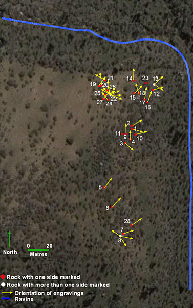
Site CB13 comprises 27 blocks with Style I and II engravings (Figure 6). The engraved rocks follow an approximate south-north line, with a low density of carvings in the south and a higher concentration in the north. The orientation of almost all blocks is towards east and north, away from the hills and towards the ravine. Since the distances separating the blocks are short, one can nearly always be seen from another, with the exception of the cluster around block 22.
Casa Blanca 13, location of blocks.

The orientation of the engraved panels coincides with the natural routes leading from the ravine westward into the foothills and to other rock art sites, specifically site CB14, which might be considered the centre of this sacred space (Reference TroncosoTroncoso 2005b). Travellers moving south-north would also be able to observe the decoration as they passed from panel to panel.
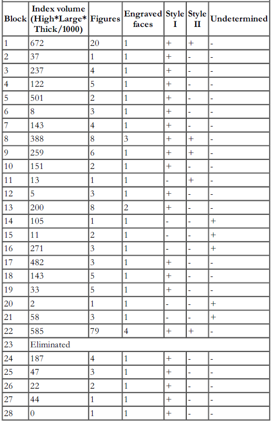
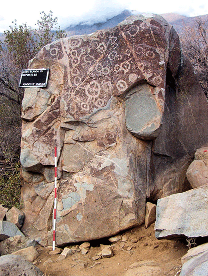
Three blocks which have more than one decorated face (8, 13 and 22) lie at different extremities of the CB13 complex (N, S and NW) and may mark points of arrival or departure. Arrival at block 22 invites a change of vista, offering a visual relationship with the western sector of the ravine, where there are different rock art sites (CB 14, CB32, CB33 and CB34). It seems therefore that block 22 - the most complex marked rock (Figure 7) - acts as a monument defining a threshold, a space with a high concentration of other blocks (Table 2), and offers a clear view of the interior to the west, but without a view of the valley.
Characteristics of marked rocks, Casa Blanca 13

Block 22, Casa Blanca 13.

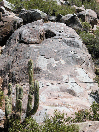
Following the route westwards from CB13, site CB 34 consists of six aligned blocks oriented towards the east. Once past CB34, the route changes course, crossing a ravine flowing west-east. Indeed a large block with petroglyphs at site CB14 (Figure 8), can only be seen from the northern terrace of the stream.
Casa Blanca 14.

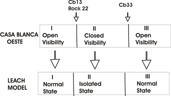
Once at site CB33, the visual structuring changes yet again. The view to the valley's fluvial terraces opens up again and it becomes possible to observe the entire sacred space, with a clear view of site CB14 as well as block 22 of CB13. I suggest that an organised visual scheme existed, leading from CB13 (open visibility), via block 22 in CB13 (closed visibility), to CB 33 (open visibility), resembling a scheme proposed by Reference LeachLeach (1976 [1993]) (Figure 9).
Interpretative rock art diagram of Casa Blanca, following Leach (1976 [1993]).

Conclusions
The characteristics of the rock engravings from site CB13 and nearby sites suggest important connexions. A series of mechanisms may have governed the movement of people: the layout of the blocks, their orientations and internal configurations deliver a set of meanings that construct local space, defining human action and the phenomenological experience at site CB13, as well as the spatial articulation between it and the other sites. Thus Casa Blanca becomes a place of social aggregation, something like a 'plaza'. The spatial organisation that acts upon the body and its movement creates an architecture without walls anchored in the alteration of the rock and the imaginary. In this place, space, mobility, visibility, rock alteration and meaning are in a close and significant relationship, which it may be possible to recover through archaeology.
Acknowledgements
Sincere thanks to Felipe Criado, Manuel Santos, Daniel Pavlovic, Rodrigo Sánchez, Martin Carver and two referees. Thanks are also due to the Museo Chileno de Arte Precolombino, who sponsored the project (Fondecyt Grant number 1040153). All mistakes are, of course, my responsibility.